kevan williams portfolio
DESCRIPTION
Landscape Architecture and Planning PortfolioTRANSCRIPT

kevan j. williamsPORTFOLIO
kevan j. williamsRESUME
2010 - Present D.O.C. Unlimited Work with a local Design-Build Architectural Firm in the documentation and design for the adaptive reuse of a historic structure. Documentation offirmworkformarketingandpromotion.2007 - Present Columnist Flagpole Magazine Write Athens Rising a bi-weekly column covering Athens Area planning, development, design, transportation issues2009 Intern UGA Office of the University Architects Developed a Campus Master Plan for Zamorano, an agricultural college in Honduras2008 - 2010 Gardening Work-Study Founder’s Memorial Garden Assisted the curator in maintenance of a historic landscape. Managed volunteer groups in the garden.2008 Planning Intern Northeast Georgia Regional Commission Performed a corridor inventory for potential bicycle-pedestrian trails in a 12 county area. Assisted in the planning of a multi-county rail-to-trail project.2006 - 2008 Lead Student Consultant SLC UGA Student Learning Center, Basic maintenance and repair of computer labs; assisted SLC users with lab issues.
200 Crestview Drive, Athens, GA 30606(706)296-6650 [email protected]
EDUCATION + AWARDS
RELEVANT SKILLS
RELEVANT WORK EXPERIENCE
University of Georgia, Class of 2010Bachelor of Landscape Architecture
ASLA Student Merit Award 2009 & 2010
Neil Reed Memorial Scholarship Recipient
Rotoract Student Service Award
HOPE Scholarship Recipient 2005-2010
Fall 2008 Named Presidential Scholar
Hand Graphics and Drafting
Computer Skills: Adobe CS3, Autocad, ArcGIS, Sketchup
Art: Painting, Digital and Manual Photography, 3-D and Furniture Design, Carpentry, Audio/
Recording Engineering
2010 EXHIBIT: THREADS - Stitching urbanism, community and ecology together in Athens, GA Coordinated with Athens Heritage Foundation to organize a one day Urban Design Symposium, which included an exhibition of newly- created student-driven design and planning concepts for Athens, GA.2010-Present Barber Street Park Project Assist the Boulevard Neighborhood with planning and designing a volunteer-built pocket park.2008 - 2010 President - Georgia Students of Landscape Architecture Work with faculty, state chapter of ASLA, and community to organize events and community service projects, and to advocate for students. 2007 - Present Board Member - Athens Grow Green Coalition Raise awareness and advocate for sustainable practices in Athens- Clarke County.2009 Intern - Athens Land Trust Worked with community associations, created conceptual designs for greenspaces, prepared conservation easement documents, GIS analysis of open space connectivity2007 Operations Director - WUOG 90.5 FM Duties included managing station equipment, as well as producing and engineering the “Sound of the City” program twice a week2008 - Present Charrette Participation Attended several charrettes through UGA Center for Community Design&Preservationdealingwithissuesrangingfrombrownfields, housing, ecotourism, public health, and campus planning. Also partici- pated in Project Riverway Summer Studio through Fanning Institute.
VOLUNTEERING/LEADERSHIP
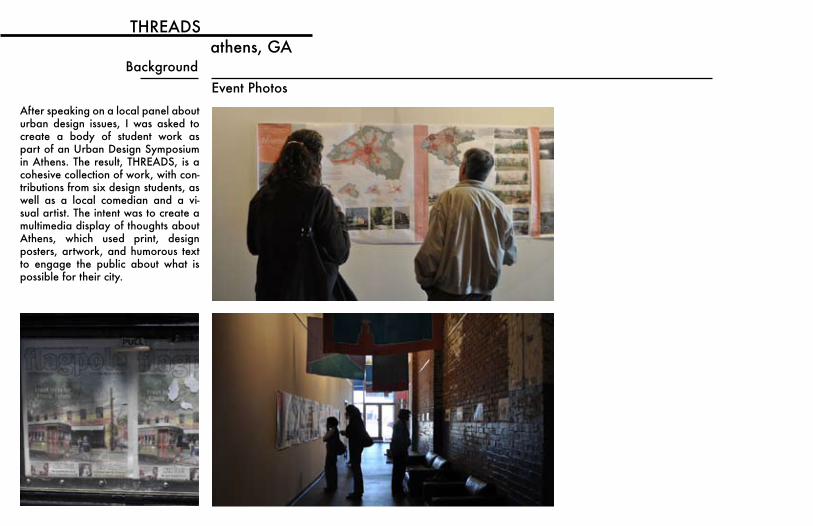
THREADSathens, GA
BackgroundEvent Photos
After speaking on a local panel about urban design issues, I was asked to create a body of student work as part of an Urban Design Symposium in Athens. The result, THREADS, is a cohesive collection of work, with con-tributions from six design students, as well as a local comedian and a vi-sual artist. The intent was to create a multimedia display of thoughts about Athens, which used print, design posters, artwork, and humorous text to engage the public about what is possible for their city.
Research Drive
Barnett Elem.Milford
Rock &Shoals
Tanyard
Hardin
Nellie B
Whit Davis Road
Falling Shoals
SoutheastClarke Park
Cherokee
Depot
Five Points
Spring Valley
Airport
Quarry
Lakewood
Woodlands
Regional Trail to:ArnoldsvilleCrawfordMaxeyʼs
Union Point
Regional Trail to:Watkinsville
BishopMadison
Regional Trail to:Old Barnett Shoals
Scull ShoalsOconee National Forest
Regional Trail to:Neese Unicorporated
Danielsville
Kenney Ridge
Middle Oconee Village
Bogart
Outer Cleveland
Winslow Park
Inner Cleveland
Bear CreekReservoir
Puritan Mill
McNutt Creek
Princeton
Beechwood
Beech Haven
Hampton Park
OglethorpeBen Burton
YMCA
Board of Ed. Homewood
BoulevardNewtown
Oconee Heights
Lantern Walk
Oak Grove
Tallassee ShoalsArcherʼs Grove
Pastel District
North Creek Village
Industrial ParkNature Center
Industrial Park
Sandy Creek Park
Old Commerce
Fourth Street
Chicopee
Carrʼs HillMMTC
PVAC
Family Housing
South Milledge
Riverbend
Soccer/Softball
Lumpkin
Memorial Park
Will Hunter
Gardens
Forest
WhitehallMill
Pinecrest
College Station
Eastside
LIVING WITH THE RIVERathens, GA
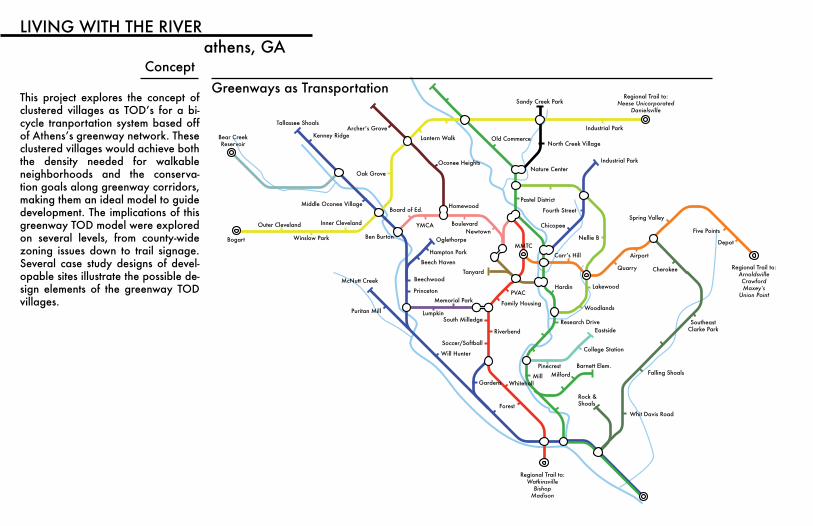
ConceptGreenways as Transportation
This project explores the concept of clustered villages as TOD’s for a bi-cycle tranportation system based off ofAthens’sgreenwaynetwork.Theseclustered villages would achieve both the density needed for walkable neighborhoods and the conserva-tion goals along greenway corridors, making them an ideal model to guide development. The implications of this greenway TOD model were explored on several levels, from county-wide zoning issues down to trail signage. Several case study designs of devel-opable sites illustrate the possible de-sign elements of the greenway TOD villages.
566
610
650
68
670
716
18
720722
726
728
594
686
616
600
672
670
642
566
672
648
652
694
636
590
650
676
688
604
670
59
8
660
696
624
686
676
570
684
602
654
66
8
64
6
08
672
582
684
650
664
656
678
678
682
596
618
632
688
692
652
622
666
620
4
638
668
644
640
664
678
658
618
660
676
634
690
612
614
592
662
674
624
674
64
8
662
630
Pine Ridge
Pinecrest Lodge
Pine Bark
Tall Pine
Birc
h V
allle
y
Whitehall Road
Pine Ridge Trace
Pinecrest Lodge Road
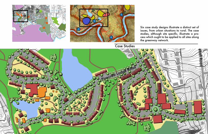
Case Studies
Six case study designs illustrate a distinct set of issues, from urban situations to rural. The case studies, although site specific, illustrate a pro-cess which ought to be applied to all sites along the greenway network.

MicroDesigns for signage, green-way street crossings, trail-heads, and neighborhood open spaces illustrate how the greenway can connect to surrounding neighbor-hoods.
MIDDLEOCONEE
McNUTTCREEK
GREENWAY
TRAILCREEK
TO DOWNTOWN1.5 MILES
NORTHOCONEE
WHITEHALL: 1.5 mi
MIDDLEOCONEE
McNUTTCREEK
GREENWAY
TRAILCREEK
TO DOWNTOWN1.5 MILES
NORTHOCONEE
WHITEHALL: 1.5 mi
MIDDLEOCONEE
McNUTTCREEK
GREENWAY
TRAILCREEK
TO DOWNTOWN1.5 MILES
NORTHOCONEE
WHITEHALL: 1.5 mi
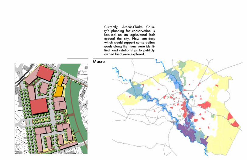
Macro
Currently, Athens-Clarke Coun-ty’s planning for conservation isfocused on an agricultural belt around the city. New corridors which would support conservation goals along the rivers were identi-fied, and relationships to publiclyowned land were explored.
0 4 0 8 0 1 2 0 2 0 F e e t
A r m s t r o n g a n d D o b b s
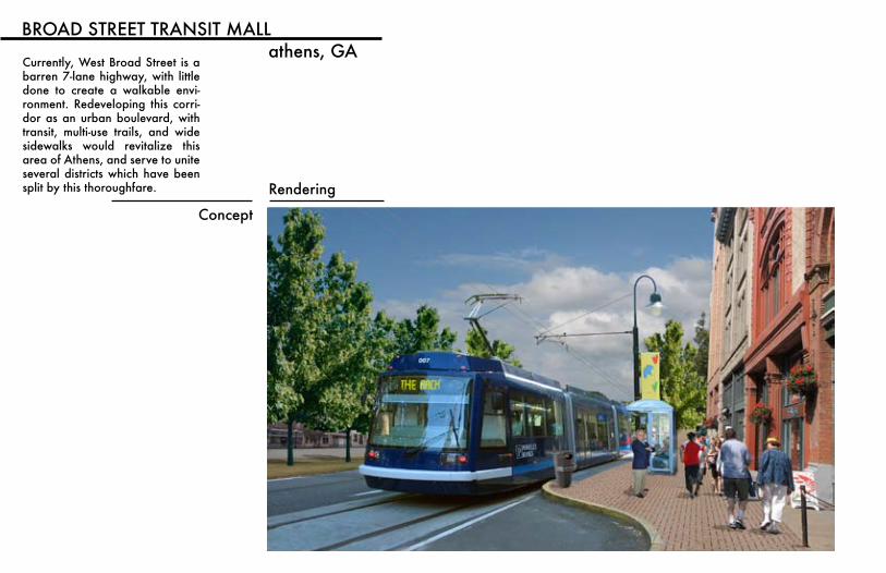
BROAD STREET TRANSIT MALLathens, GA
Concept
Rendering
Currently, West Broad Street is a barren 7-lane highway, with little done to create a walkable envi-ronment. Redeveloping this corri-dor as an urban boulevard, with transit, multi-use trails, and wide sidewalks would revitalize this area of Athens, and serve to unite several districts which have been split by this thoroughfare.
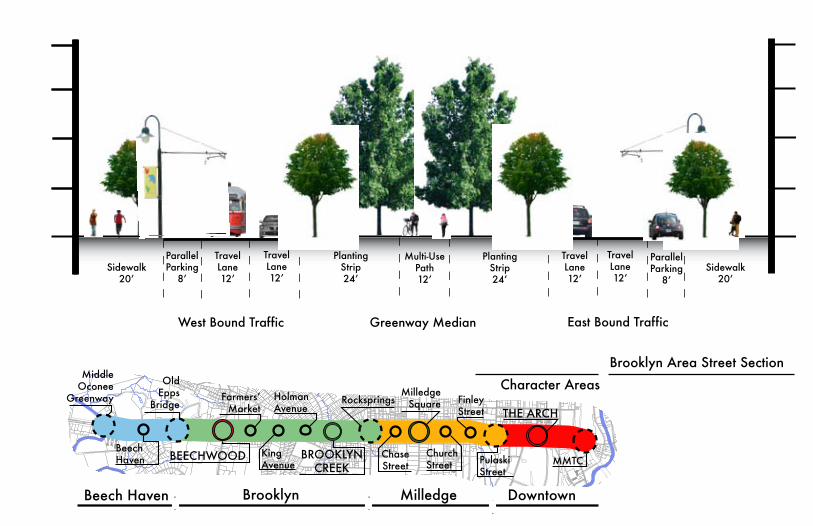
Greenway MedianWest Bound Traffic East Bound Traffic
TravelLane12ʼ
TravelLane12ʼ
TravelLane12ʼ
TravelLane12ʼ
ParallelParking
8ʼ
ParallelParking
8ʼ
Multi-Use Path12ʼ
Planting Strip24ʼ
Planting Strip24ʼ
Sidewalk20ʼ
Sidewalk20ʼ
Beech Haven Brooklyn Milledge Downtown
THE ARCH
BROOKLYN CREEK
BEECHWOODBeech Haven
MiddleOconee
Greenway
OldEpps
Bridge
KingAvenue
HolmanAvenue
FarmersʼMarket
Rocksprings
ChaseStreet
MilledgeSquare Finley
Street
PulaskiStreet
ChurchStreet MMTC
Character AreasBrooklyn Area Street Section
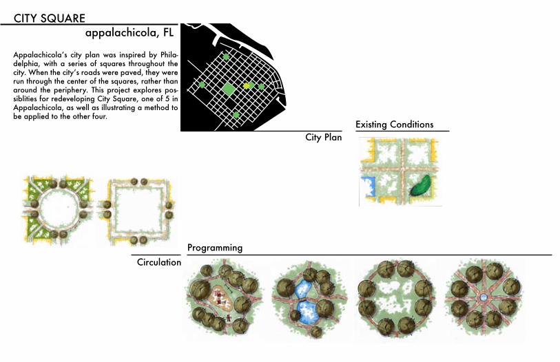
CITY SQUAREappalachicola, FL
City Plan
Appalachicola’s city plan was inspired by Phila-delphia, with a series of squares throughout the city.Whenthecity’sroadswerepaved,theywererun through the center of the squares, rather than around the periphery. This project explores pos-siblities for redeveloping City Square, one of 5 in Appalachicola, as well as illustrating a method to be applied to the other four.
ProgrammingCirculation
Existing Conditions
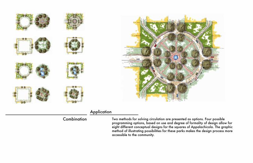
Combination
ApplicationTwo methods for solving circulation are presented as options. Four possible programming options, based on use and degree of formality of design allow for eight different conceptual designs for the squares of Appalachicola. The graphic method of illustrating possibilities for these parks makes the design process more accessible to the community.
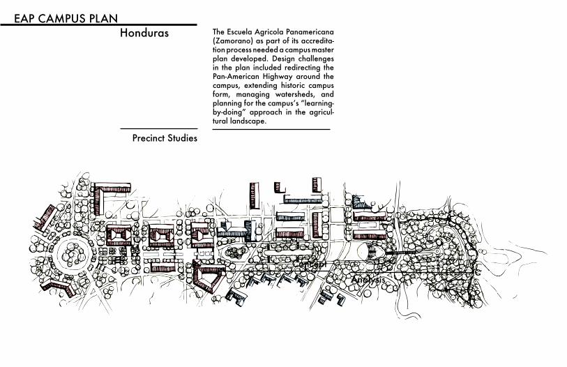
The Escuela Agricola Panamericana (Zamorano) as part of its accredita-tion process needed a campus master plan developed. Design challenges in the plan included redirecting the Pan-American Highway around the campus, extending historic campus form, managing watersheds, and planningforthecampus’s“learning-by-doing” approach in the agricul-tural landscape.
EAP CAMPUS PLANHonduras
Precinct Studies
Concept
Analysis
Southwes t
Precinct Plan
Greenspace, Housing, and Student L i fe
VA
LE
D D
RIV
E
Reforestation e�orts on either
side of the approach road into
campus will help to create a
dramatic entry to the campus.
Woodland corridors will screen
the campus from visitors so that
their first view upon entering the
campus will be of the Zemurray
Circle. This wooded corridor
will also have numerous eco-
logical benefits.
CA
MPU
S LIFE
Extending southwest from the
existing comedor, a new zone
will be created for student life, in-
cluding new recreational fields and
facilities. Rather than existing as a
separate recreational complex, the
the new fields will be integrated into
Zamorano’s formal framework, and
serve as an elegant foreground to the Con-
vocation Pavilion’s view of Uyuca Mountain.
CONVOCATIONThe prominent
Convocation Pavil-
ion rising above the tree-
tops will be the first sight of
Zamorano for many entering the
valley. The pavilion lies at the crossroads of
Zamorano’s three distinct building grids; its lo-
cation will allow it to become an orientation point for
navigating the campus. The central plan of the structure is
unique on campus, and helps to denote its special purpose
as a place for formal ceremonies such as convocation or
graduation.
DORMS + QUADS
Paths extending from the Zemurray Circle, Zamorano’s histori-
cal center, will define the circulation of this new housing pre-
cinct and the placement of the new dorm clusters. Alternating
bands of housing and open space connect this area to the
campus’s greater open space network, and ecological frame-
work. Within each cluster of dorms is an opportunity for a
unique courtyard space for students. The quad spaces be-
tween each row of housing extends from Zamorano’s
“learn by doing” facilities toward the convoca-
tion pavilion, suggesting the progress the
students will make at Zamorano.
WORKING AREAS
A wooded bu�er separates housing
from adjacent working areas, pro-
viding some quiet and privacy for
residents nearer to active opera-
tions. The wooded treatment of
the area also visually ties
these working areas
into the
campus.
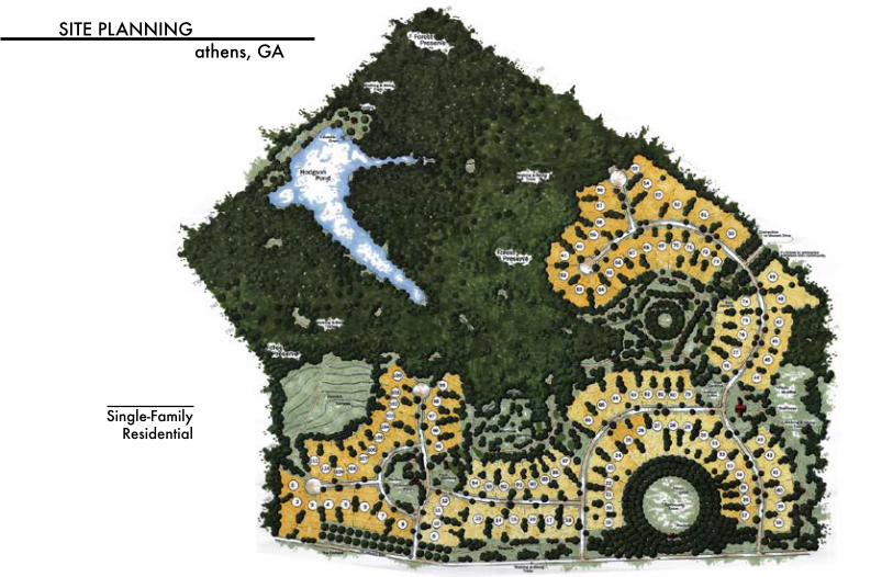
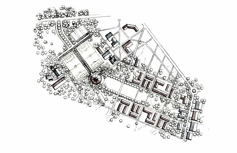
Single-FamilyResidential
SITE PLANNINGathens, GA
150151
152
148
153154 155 156
185
186
187
188
141140
139138
142143
144145
146147
137136
135
134
133 132131
130129
128 127126
125 124123
122121
184 183 182 181 180
160 161 162 163
159
158
157
199 198
189 190 191
164165
166167
168169
170171
172
173
174175176177178179
197
196
192193
194195
11
10
9
8
7 6
5
4
3
2 1
12 13
27
14
15
16
17
28
29
30
31
32
33
18
19
20
21
22
23
24
25
26
45
46 47 48
49
50
51
34
35 36 37 38
39
40
41
42
4344
52
53
54
55
56
61
62
63
64
65
60 59 58
57
82
66
67
83 68
69 70
71
72
76
75
74
73
77
84 85
78 79
80 81
86 87
88
89
90
91
92
94
93
103104
95
102101100 99
96 97
98
105
106 107 108 109 110111
112113 114
116117
118119 120
115
Village Greenway View
Porch View of Greenway
149
Village Commons
Organic Farm
Wetland Overlook
Creekside Trail
Vineyard Terraces
Village Greenway
Church
Pharmacy
Grocery
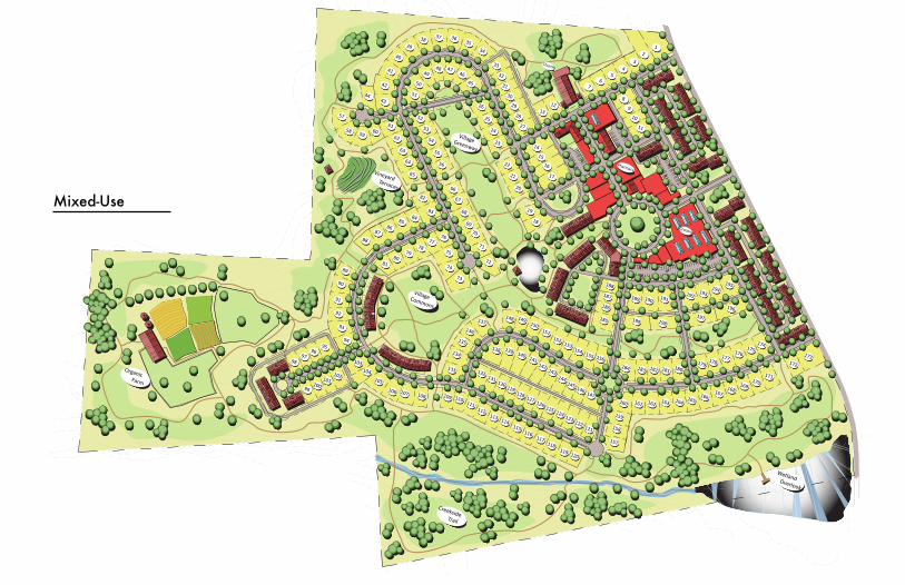
PIEDMONT VILLAGECommunity Features:
Pedestrian Greenways right out your door
Organic Farming in your backyard
Miles of woodland trails
A walkable village center with grocery,
pharmacy, daycare, and hardware store.
Energy Efficient Homes
A Chapel for Community Gatherings
The Stats:199 Detached Homes118 Townhomes
40 Loft Apartments
120,000sqft. of
Retail/Office Space 74 Acres of
Greenspace(57%)
O’
100’200’
400’600’
North
Mixed-Use
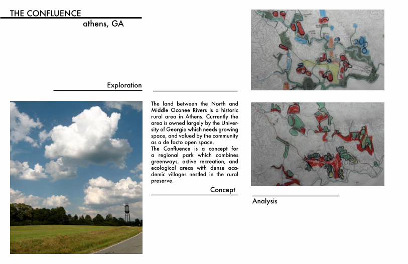
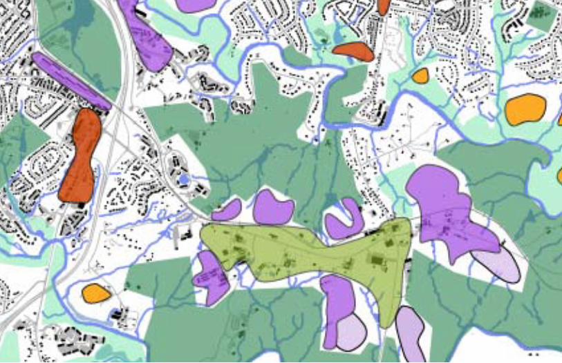
THE CONFLUENCEathens, GA
Exploration
The land between the North and Middle Oconee Rivers is a historic rural area in Athens. Currently the area is owned largely by the Univer-sity of Georgia which needs growing space, and valued by the community as a de facto open space. The Confluence is a concept fora regional park which combines greenways, active recreation, and ecological areas with dense aca-demic villages nestled in the rural preserve.
Concept
Analysis


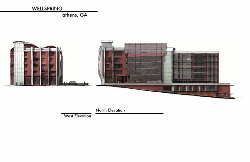
WELLSPRINGathens, GA
West ElevationNorth Elevation
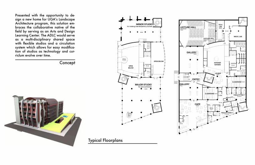
Concept
Presented with the opportunity to de-signanewhomeforUGA’sLandscapeArchitecture program, this solution em-braces the collaborative native of the fieldbyservingasanArtsandDesignLearning Center. The ADLC would serve as a multi-disciplinary shared space with flexible studios and a circulationsystemwhichallowsforeasymodifica-tion of studios as technology and cur-riclum evolve over time.
OPEN BELOW
StorageOPENBELOW
MINOR STUDIOfor rotating interdisciplinary courses
UP
DN
SeatingOverlook
MAJOR STUDIOfor core curriculum
SHARED STUDIOfor interdisciplinary collaboration
75x30StorageOPEN
BELOW
MINOR STUDIOfor rotating interdisciplinary courses
UP
UP
DN
SmallCrit Space
MAJOR STUDIOfor core curriculum
StudyOverlook
DN
OPENBELOW
DN
Storage
OPENBELOW
MINOR STUDIOfor rotating interdisciplinary courses
UP
UP
UP
SmallCrit Space
MAJOR STUDIOfor core curriculum
StudyOverlook
DN OPENBELOW
UP
SHARED STUDIOfor interdisciplinary collaboration
75x30
Storage
OPENBELOW
MINOR STUDIOfor rotating interdisciplinary courses
UP
UP
MAJOR STUDIOfor core curriculum
DN OPENBELOW
UP
OPENBELOW
ROOF GARDEN
UP
ROOF GARDEN
LoungeOverlook
GREEN HOUSE LAB
75x30
LEVEL 4LEVEL 5
LEVEL 6LEVEL 7
LEVEL 8
W E L L S P R I N Gan arts and design learning centerkevan williams fall2009 FLOOR PLANS
0’
5’
10’
20’
40’
SCALE 1”=16’
SHEET 2
70x80
45x80
DN
60x80
45x8045x80 45x80
90x80 75x80
OPENBELOW
UP
UP
UP DN
DN
UP
DN
UP
DN
UP
UP
UP DN
DN
UP
DN
UP
DN
UP
UP
UP DN
DN
UP
DN
UP
DN
UP
UP
UP DN
DN
UP
DN
UP
DN
UP
DN
DN
north
GALLERY40x50
CAFE60x60
FACULTY POD 1(6 offices)
FACULTY POD 2(7 offices)
Meeting Room
Storage
Storage
Kitchen
CLASSROOM
CLASSROOM
MECH/LAB
GALLERY50x55
Corridor
Men’s Locker Room
Women’s Locker Room
Corridor
TECHLAB
Storage
Storage
Storage
LECTURE HALL(capacity 299)50x55
LECTURE HALL(capacity 107)30x45
rem
ovab
le p
arti
tion
UP
UP
UP
UP
UP
LOUNGE
INTERIORGARDEN
ENTRY30x20
ADMIN45x35
FACULTY POD 3(6 offices)
FACULTY POD 4(6 offices)
Storage
Storage
TECH OFFICE35x22
CLASSROOM20x25
Corridor
TECHLAB30x20
Storage
UP
UP
UP
UP
UP
DN
LOADING DOCK44x15
OPENBELOW
OPENBELOW
UP
Corridor
FACULTY POD 5(7 offices)
Conference Room20x20
DN
DN
DN
SUNKENENTRY
serves as Clerestory for Gallery Below
Skylight abovewith planting zone below
Reception
GREEN ROOF
PLAZA
SeatingOverlook
ENTRY/AMPHITHEATRE
WORKSHOP30x75
Storage
UP
UP
UP DN
OPENBELOW
Circulation
DN
SUNKENENTRY
DN
FLEXFOYERmulti-disciplinary studio/performance space
LIBRARY
UPUP
UP
UP
UP
UP
SeatingOverlook
LEVEL 1LEVEL 2
LEVEL 3
W E L L S P R I N Gan arts and design learning centerkevan williams fall2009 FLOOR PLANS
0’
5’
10’
20’
40’
SCALE 1”=16’
north
SHEET 1
Storage
Storage
22x30
35x30
22x40
20x40
ENTRY30x20
44x22
60x25
85x80
JACKSON STREET
UP
UP
DN
UP
DN
SPRING STREET
Typical Floorplans
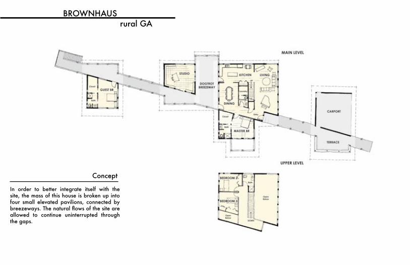
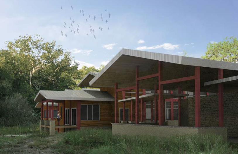
BROWNHAUSrural GA
In order to better integrate itself with the site, the mass of this house is broken up into four small elevated pavilions, connected by breezeways.Thenaturalflowsofthesiteareallowed to continue uninterrupted through the gaps.
Concept
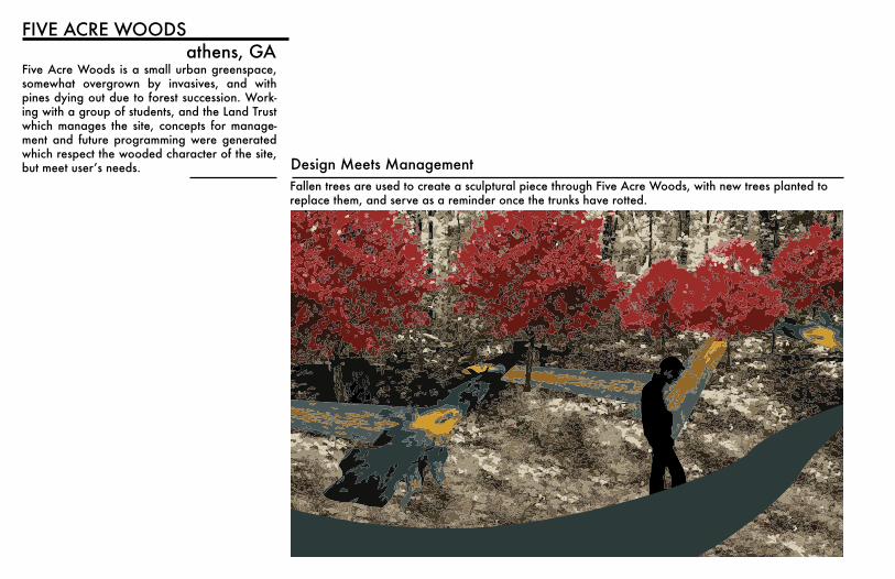
Five Acre Woods is a small urban greenspace, somewhat overgrown by invasives, and with pines dying out due to forest succession. Work-ing with a group of students, and the Land Trust which manages the site, concepts for manage-ment and future programming were generated which respect the wooded character of the site, butmeetuser’sneeds.
FIVE ACRE WOODSathens, GA
Design Meets ManagementFallen trees are used to create a sculptural piece through Five Acre Woods, with new trees planted to replace them, and serve as a reminder once the trunks have rotted.
Eleven Acre WoodsNeighborhood Greenway
CommunityGardens
Playground
Native Plant Garden
SuccessionalLand Art
PlayField
Wildflower Meadow
Existing Entrances
Proposed Ruth Street Entrance
(Proposed) (Proposed)
(Proposed)
(Proposed)
Proposed AlleyEntrances NORTHSIDE DRIVE
Ruth Street
Lake
Stre
et
North
Aven
ue
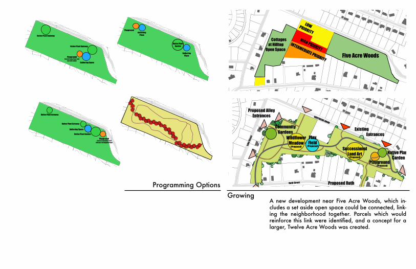
Five Acre Woods12 ACRE WOODSGrowing Five Acre Woods through Neighborhood Connections
Prepared for the Athens Land Trustwww.athenslandtrust.org 706 613.01222
LIKELY INFILL
Five Acre Woods
Cottages at Hilltop
Open Space
HIGH PRIORITYINTERMEDIATE PRIORITY
LOW PRIORITY
Five Acre Woods
Programming OptionsGrowing
m
0 75 150 225 30037.5Feet
Five Acre WoodsProgramming Option A
Native Plant Gateway
Native Plant Gateway
Gathering Space
Native Plant Garden
Playgroundserves as Architectural
Entrance to Neighborhood
m
0 75 150 225 30037.5Feet
Five Acre WoodsTrails and Gateways
m
0 75 150 225 30037.5Feet
Five Acre WoodsProgramming Option B
Native Plant Garden
Gathering Place
PlaygroundGathering
Place
m
0 75 150 225 30037.5Feet
Five Acre WoodsProgramming Option C
Playgroundlocated away from road
but still visibleGathering Space
Native Plant Gateway
Native Plant Gateway
A new development near Five Acre Woods, which in-cludes a set aside open space could be connected, link-ing the neighborhood together. Parcels which would reinforcethis linkwereidentified,andaconceptforalarger, Twelve Acre Woods was created.
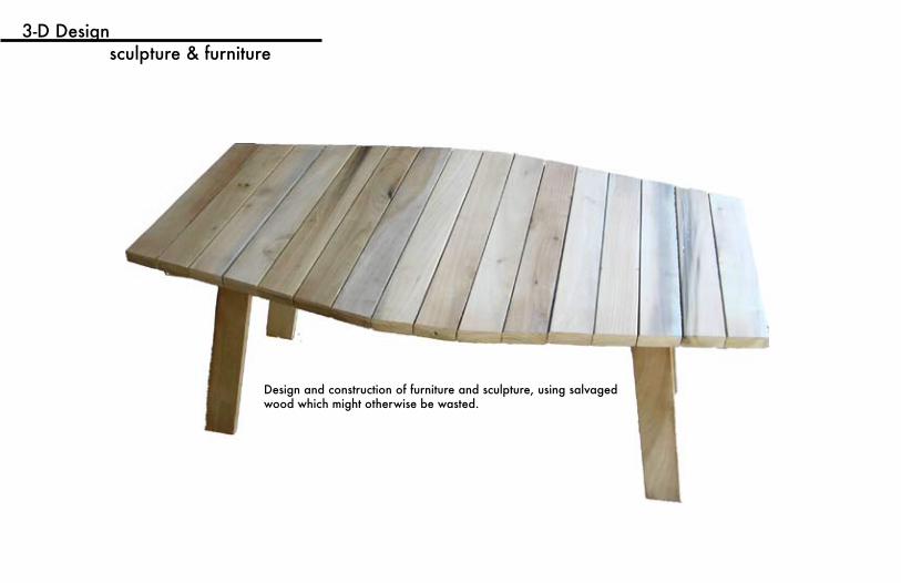
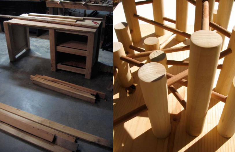
3-D Designsculpture & furniture
Design and construction of furniture and sculpture, using salvaged wood which might otherwise be wasted.
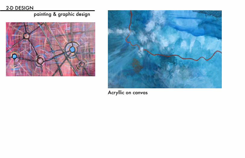
2-D DESIGNpainting & graphic design
Acryllic on canvas
Ç
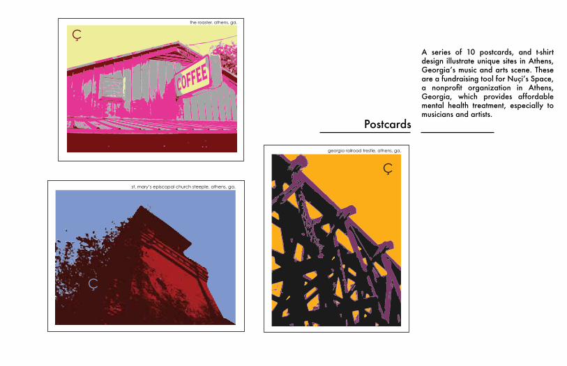
georgia railroad trestle. athens, ga.
Ç
st. mary’s episcopal church steeple. athens, ga.
Çthe roaster. athens, ga.
Postcards
A series of 10 postcards, and t-shirt design illustrate unique sites in Athens, Georgia’smusicandartsscene.TheseareafundraisingtoolforNuçi’sSpace,a nonprofit organization in Athens,Georgia, which provides affordable mental health treatment, especially to musicians and artists.