khazzan phase ii cpf feed, hydrology case study · khazzan phase ii cpf feed, hydrology case study...
TRANSCRIPT

Khazzan Phase II CPF FEED, Hydrology Case Study
Authors: M Moder, T Strohbach, R Scheepers, R Stollberg

www.fugro.com 2 To change footer text go to Insert > Header & Footer
Khazzan tight gas field, located app. 350 km south-west of Muscat
Site description

www.fugro.com 3 To change footer text go to Insert > Header & Footer
Site description

www.fugro.com 4
Introduction / Objectives
Identification of flow rates, water depths and velocities for 10 to 10,000 year return period floods including adjacent Phase 1 and Phase 2
Evaluation of the duration of water impoundment and the associated risks to the permanent and temporary facilities
Recommendations regarding engineering / construction solutions based on found field conditions and hydrological modelling with regards to scour risk, local site management (temporal/permanent facilities), and flood protection
Recommendations for flood protection during construction
Evaluation of potential diversion of wadi flow, road crossings and flow around Evaporation Pond
Check lateral seepage/ponding effect to CPF/CPF extension
General requirements for effective local site management along with expert recommendations to mitigate involved uncertainties
To change footer text go to Insert > Header & Footer

www.fugro.com 5 To change footer text go to Insert > Header & Footer
Verification and modification of hydrographs from previous CPF1-related investigation
Unit Hydrograph Methodology
Wadi Catchment Hydrology
Sub catchment A
Sub catchment B
Sub catchment C
Assessment hydrographs

www.fugro.com 6 To change footer text go to Insert > Header & Footer
Hydrodynamic simulation
Modelling stage Pre-processing Modelling Post-processing
Description
Data Preparation
(DTM, Boundary
conditions, Land use,
Bathymetry)
Model setup
Model simulation
Extraction Analysis
Tool used ArcGIS, SMS HYDRO_AS-2D
SMS, ArcGIS, Excel
Conceptual chart for hydraulic modelling

www.fugro.com 7 To change footer text go to Insert > Header & Footer
Elevation information
DEM Topographical Survey (1x1m resolution)
including soil testing

www.fugro.com 8 To change footer text go to Insert > Header & Footer
Mesh Generation

www.fugro.com 9 To change footer text go to Insert > Header & Footer
Modelling Scenario 1: In situ Situation: 10, 50, 100, and 10,000 years
Modelling Scenario 2: Construction Phase of CPF2: 10 and 50 years
Modelling Scenario 3: CPF2 Construction Finished with Camp: 100 and 10,000 years
Modelling Scenario 4: CPF2 Construction Finished without Camp: 10, 50, 100 and 10,000 years
Modelling Scenario 5: CPF2 Construction Finished without Camp and with Potential Bund Failure: only 10,000 years
Modeling Scenarios and Results
Results for all scenarios:
1. Digital results for implementation into clients GIS data base (*.shp, *.grd etc.)
2. Maps of water level, water depths and flow velocities
3. Evaluation and suggestion of protection measures
4. Technical presentation / Factual reporting and interpretation

www.fugro.com 10 To change footer text go to Insert > Header & Footer
Example for Scenario 4: 10,000 year event
Modeling Scenarios and Results
Water depth [m]
0 - 0,5
0,5 - 1,0
1,0 - 1,5
1,5 - 2,0
2,0 - 2,5
2,5 - 3,0
> 3,0
Water Level [m ASL]
92 - 92,25
91,75 - 92
91,5 - 91,75
91,25 - 91,5
91 - 91,25
90,75 - 91
90,5 - 90,75
90,25 - 90,5
90 - 90,25
89,75 - 90
89,5 - 89,75
89,25 - 89,5
89 - 89,25
88,75 - 89
88,5 - 88,75
88,25 - 88,5
88 - 88,25
87,75 - 88
87,5 - 87,75
87,25 - 87,5
87 - 87,25
86,75 - 87
86,5 - 86,75
86,25 - 86,5
86 - 86,25
85,75 - 86
85,5 - 85,75
85,25 - 85,5
85 - 85,25

www.fugro.com 11 To change footer text go to Insert > Header & Footer
Scour Risk Analysis for all scenarios
www.fugro.com 12 To change footer text go to Insert > Header & Footer
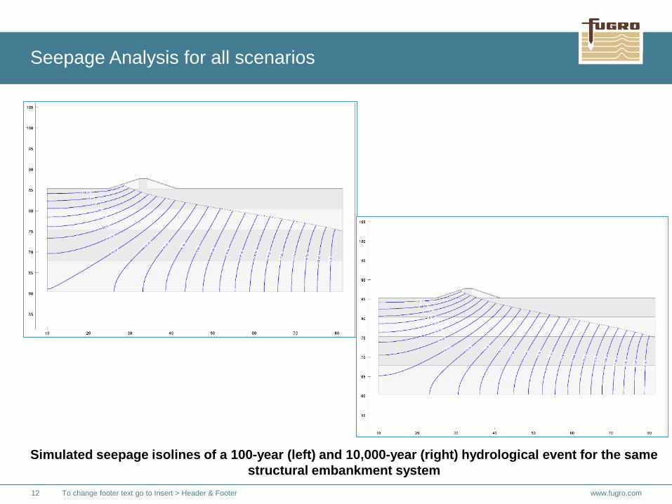
Seepage Analysis for all scenarios
Simulated seepage isolines of a 100-year (left) and 10,000-year (right) hydrological event for the same
structural embankment system

www.fugro.com 13 To change footer text go to Insert > Header & Footer
1. Depending on the scenario surface flow conditions were estimated for a different number of flood events with a return period between 10 and 10,000 years.
2. For all scenarios and all estimated flood events the results were analyzed: water depths, maximum water level, velocities and scour risk.
3. The potential seepage effect on the CPF vehicle dam and the bund wall around the evaporation pond for all relevant was investigated.
4. Results of no single scenario indicate that seepage line hits the surface level at related dams or ground levels of the . Application of the larger flood event results in a higher seepage line.
5. Potential pounding effects near evaporation pond facility -> STABILITY ANALYSIS.
Summary – Benefits for further construction phase

www.fugro.com 14 To change footer text go to Insert > Header & Footer
6. Mitigation option: It was checked whether a suitable protection against flooding can be achieved with the extension of the CPF bund in western direction to the camp bund and the diversion of the water west of the camp. The necessary crest height of the bund to prevent flooding up to the 10,000 year event and to retain the volume of the hydrograph was identified. To discharge the water in 100 year event into neighboring catchments or into the wadi south of the Evaporation pond, a channel is necessary. The channel must cross the watershed boundary west of the camp. This is not suitable (channel length 3 km, channel width up to 25 m and depth up to 5 m, depending on detailed design). Therefore, such solution was not pursued.
7. After grading of the CPF2 area the two years construction phase of the CPF2 starts. Therefore, the investigation was performed only for a 10 and 50 year event. For both events no additional flood protection measures for the CPF2 are required although a protection dam between CPF1 and construction area CPF2 will not be installed.
8. Within all scenarios the camp is flooded due to an opening in the security bund at the eastern boundary. The width of the gap is 20 m. To avoid this effect the provision of a temporary (mobile) flood protection scheme (e.g. big bags) is suggested.
9. For a flood event with return period of 10,000 years the camp bund is partially also overflowed. Because the camp doesn’t require a flood protection level of 10,000 years no measures are necessary.
Summary

Click to add the title of the Frontpage
Thank you for your kind attention!