kirby road extension - vaughan
TRANSCRIPT

Kirby Road Extension Environmental Assessment Study
Public Information Centre #2
Vaughan Civic Centre Resource Library
June 28, 2018

Kirby Road Extension EAS
Why are we here?
Public Information Centre #2
Answer questions you may have about the
project
Ask for your input
Share with you the:
Study Background
Study Process
Alternative Design Concepts under consideration
Evaluation of Alternative Design Concepts
Recommended Design Concepts for Road Cross-Section and Horizontal Alignment
Discuss next steps
Provide an opportunity for you to meet members
of the project team
Establish two-way communication between the study proponent and interested stakeholders to influence decision making and to provide opportunities for information exchange.
Foster public trust and confidence by demonstrating that RHL is following a comprehensive consultation and sound decision making processes.
Consultation Objectives
Consultation early in and throughout the process is a key feature of environmental assessment planning.
EAS
Project Team
Study Proponent
RHL
First Nations
Public
Provincial
Federal
Public Authorities
Citizen Liaison
Committee
Technical Advisory
Group
Completed public and project stakeholders consultation steps:
Notice of Study Commencement May 2017 TAG #1 Meeting June 2017 CLC #1 Meeting June 2017 Notice of PIC#1 June 2017 PIC #1 June 2017
Site walk with technical review agencies
in August 2017 TAG #2 June 2018 CLC #2 June 2018 Notice of PIC #2 June 2018
Current mailing list includes 94 stakeholders , 12 First Nations (FN) and Metis Nation of Ontario.
Kirby Road Extension EAS
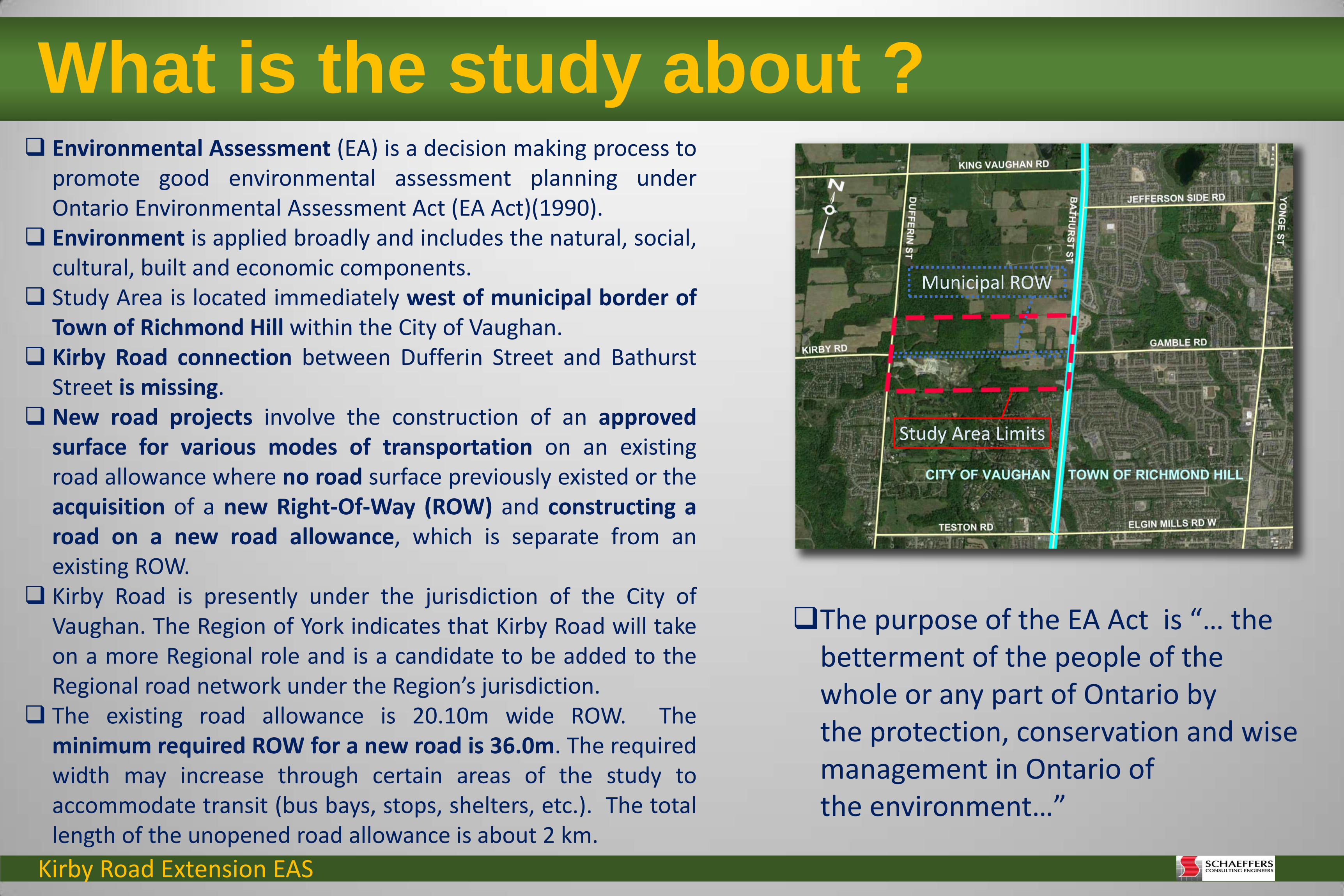
What is the study about ?
Environmental Assessment (EA) is a decision making process to promote good environmental assessment planning under Ontario Environmental Assessment Act (EA Act)(1990).
Environment is applied broadly and includes the natural, social, cultural, built and economic components.
Study Area is located immediately west of municipal border of Town of Richmond Hill within the City of Vaughan.
Kirby Road connection between Dufferin Street and Bathurst Street is missing.
New road projects involve the construction of an approved surface for various modes of transportation on an existing road allowance where no road surface previously existed or the acquisition of a new Right-Of-Way (ROW) and constructing a road on a new road allowance, which is separate from an existing ROW.
Kirby Road is presently under the jurisdiction of the City of Vaughan. The Region of York indicates that Kirby Road will take on a more Regional role and is a candidate to be added to the Regional road network under the Region’s jurisdiction.
The existing road allowance is 20.10m wide ROW. The minimum required ROW for a new road is 36.0m. The required width may increase through certain areas of the study to accommodate transit (bus bays, stops, shelters, etc.). The total length of the unopened road allowance is about 2 km.
Study Area Limits
Municipal ROW
The purpose of the EA Act is “… the betterment of the people of the whole or any part of Ontario by the protection, conservation and wise management in Ontario of the environment…”

Kirby Road Extension EAS
As part of this EAS, Phases 1 and 2 of the Municipal Class EA have been revisited and Phases 3 and 4 are being completed by the RHL, a private sector developer acting as the study Proponent.
The EAS considers and evaluates Alternative Design Concept(s) for the new roadway. It will identify a Preferred Design Concept(s) and complete an Environmental Study Report (ESR).
The ESR will be provided to the City of Vaughan, who will determine whether or not to issue a Notice of Study Completion as a Study co-Proponent and file the ESR for mandatory public review.
Rizmi Holdings Limited (RHL) has been authorized by the City of Vaughan to undertake the necessary Environmental Assessment Study (EAS) to establish the preferred alignment and design for the extension of Kirby Road between Dufferin Street and Bathurst Street.
The EAS is being planned as a Schedule ‘C’ Municipal Road Project in accordance with the Municipal Engineers Association (MEA) Municipal Class Environmental Assessment (MCEA) Document (2000, as amended).
The Class EA is a planning and design process defined under Ontario EA Act for a group or “Class” of projects.
The Municipal Class EA is an approved process which applies to a group of municipal infrastructure projects including roads, water, wastewater and transit.
In the MEA MCEA Document, projects are categorised into four Schedules (A, A+, B, C) given the nature of the project, its complexity and magnitude of anticipated environmental effects.
The Municipal Class EA provides a framework for the EAS planning. This is a self-assessment process where the responsibility for the process and compliance with its requirements rests with the study proponent. Subject to compliance with the Municipal Class EA, the new road project is deemed to fulfill the requirements of the EA Act.
New road projects which have high potential for significant effects on the environment must follow the Schedule ‘C’ planning procedure outlined in the MEA MCEA Document.
Phases 1 and 2 of the Municipal Class EA have been completed and addressed in the 2013 City of Vaughan Transportation Master Plan (TMP) and 2016 York Region TMP.
What is the study about ?
Kirby Road Extension EAS
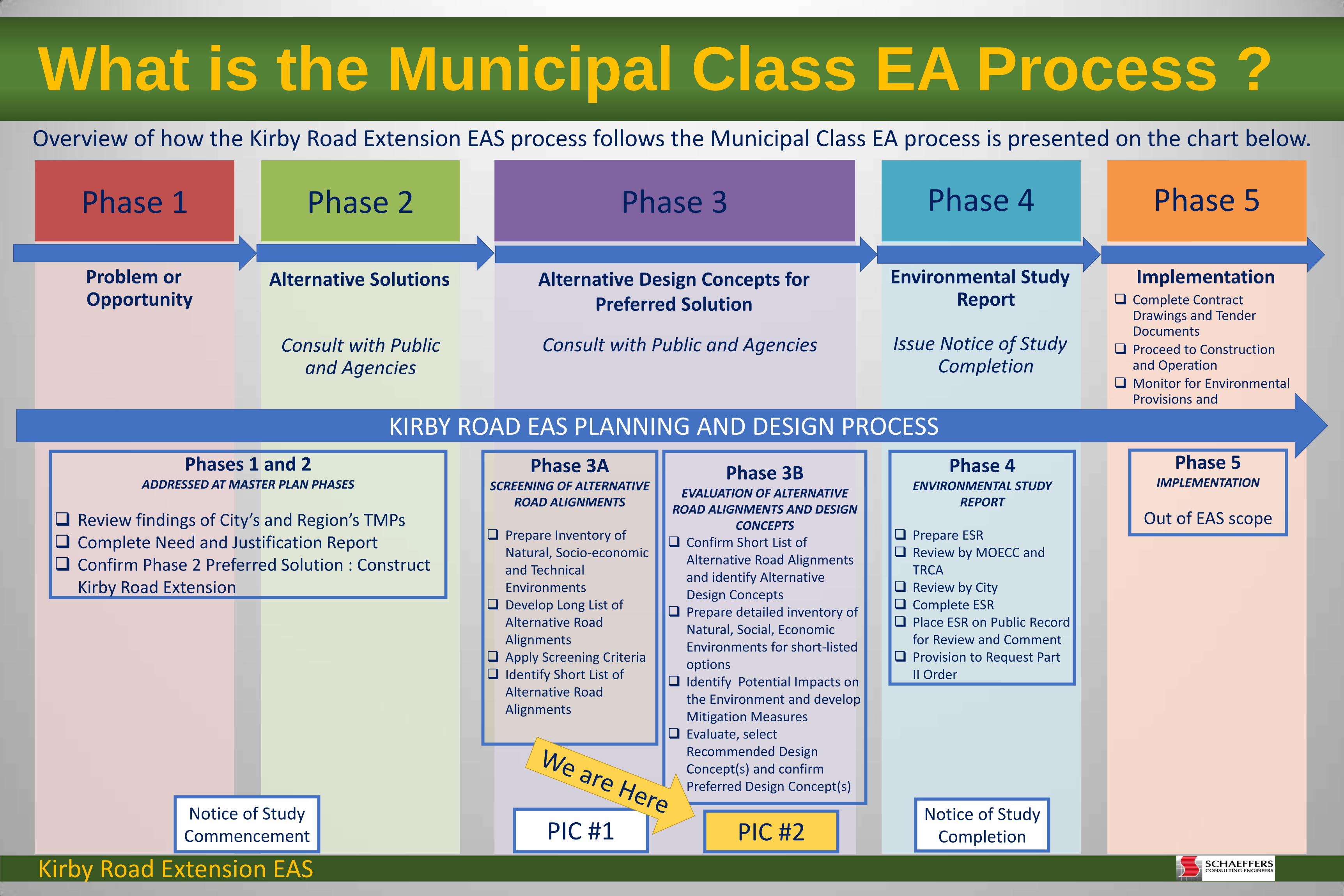
Phase 1
Problem or Opportunity
Phase 2
Alternative Solutions
Consult with Public and Agencies
Phase 3
Alternative Design Concepts for Preferred Solution
Consult with Public and Agencies
Phase 4
Environmental Study Report
Issue Notice of Study Completion
Phase 5
Implementation Complete Contract
Drawings and Tender Documents
Proceed to Construction and Operation
Monitor for Environmental Provisions and Commitments
What is the Municipal Class EA Process ?
KIRBY ROAD EAS PLANNING AND DESIGN PROCESS
Phases 1 and 2 ADDRESSED AT MASTER PLAN PHASES
Review findings of City’s and Region’s TMPs Complete Need and Justification Report Confirm Phase 2 Preferred Solution : Construct
Kirby Road Extension
Phase 3A SCREENING OF ALTERNATIVE
ROAD ALIGNMENTS
Prepare Inventory of Natural, Socio-economic and Technical Environments
Develop Long List of Alternative Road Alignments
Apply Screening Criteria Identify Short List of
Alternative Road Alignments
Phase 3B EVALUATION OF ALTERNATIVE
ROAD ALIGNMENTS AND DESIGN CONCEPTS
Confirm Short List of Alternative Road Alignments and identify Alternative Design Concepts
Prepare detailed inventory of Natural, Social, Economic Environments for short-listed options
Identify Potential Impacts on the Environment and develop Mitigation Measures
Evaluate, select Recommended Design Concept(s) and confirm Preferred Design Concept(s)
Phase 4 ENVIRONMENTAL STUDY
REPORT
Prepare ESR Review by MOECC and
TRCA Review by City Complete ESR Place ESR on Public Record
for Review and Comment Provision to Request Part
II Order
Phase 5 IMPLEMENTATION
Out of EAS scope
PIC #1 Notice of Study
Completion Notice of Study
Commencement
Overview of how the Kirby Road Extension EAS process follows the Municipal Class EA process is presented on the chart below.
PIC #2
Kirby Road Extension EAS
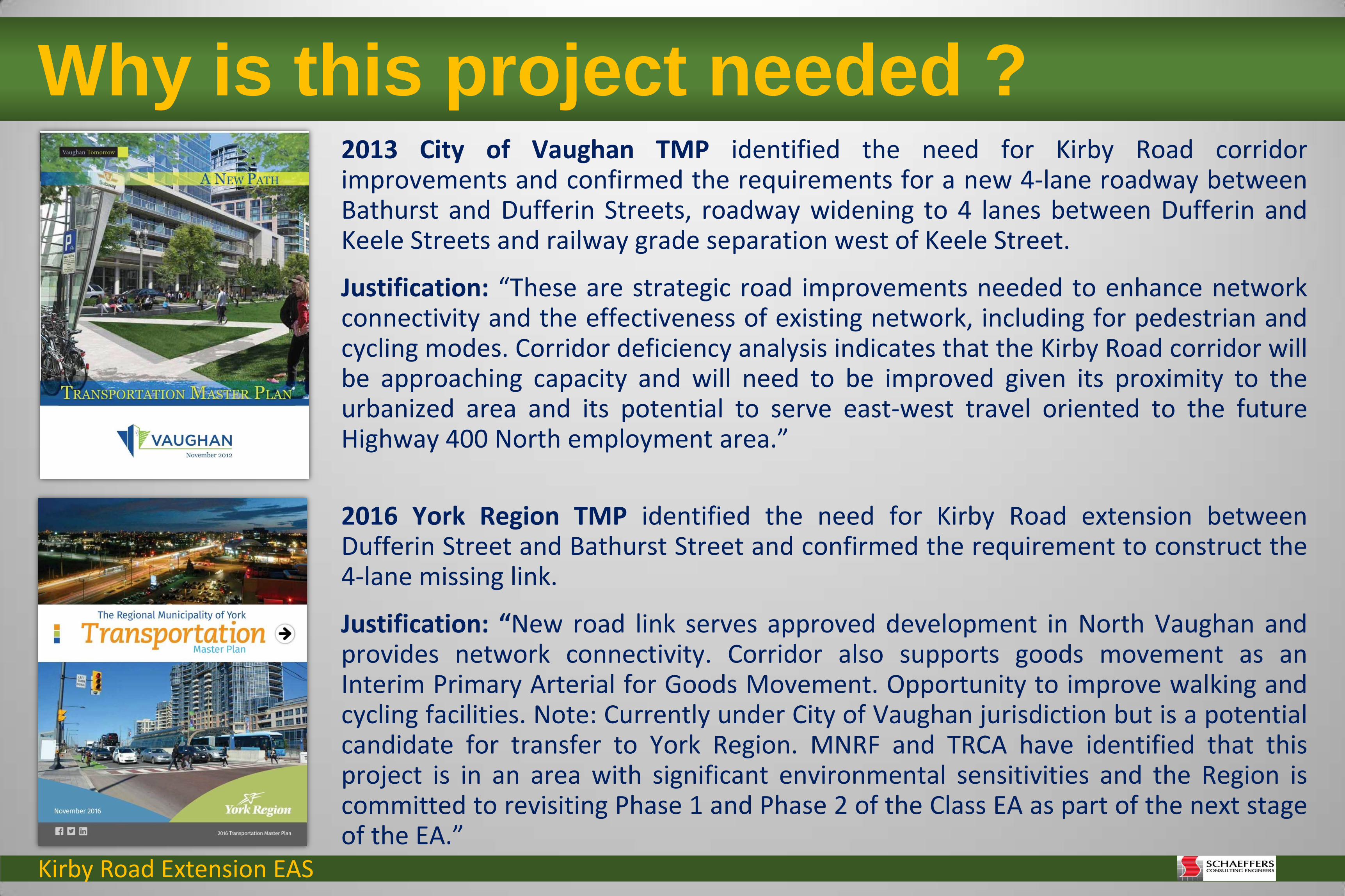
Why is this project needed ? 2013 City of Vaughan TMP identified the need for Kirby Road corridor improvements and confirmed the requirements for a new 4-lane roadway between Bathurst and Dufferin Streets, roadway widening to 4 lanes between Dufferin and Keele Streets and railway grade separation west of Keele Street.
Justification: “These are strategic road improvements needed to enhance network connectivity and the effectiveness of existing network, including for pedestrian and cycling modes. Corridor deficiency analysis indicates that the Kirby Road corridor will be approaching capacity and will need to be improved given its proximity to the urbanized area and its potential to serve east-west travel oriented to the future Highway 400 North employment area.”
2016 York Region TMP identified the need for Kirby Road extension between Dufferin Street and Bathurst Street and confirmed the requirement to construct the 4-lane missing link.
Justification: “New road link serves approved development in North Vaughan and provides network connectivity. Corridor also supports goods movement as an Interim Primary Arterial for Goods Movement. Opportunity to improve walking and cycling facilities. Note: Currently under City of Vaughan jurisdiction but is a potential candidate for transfer to York Region. MNRF and TRCA have identified that this project is in an area with significant environmental sensitivities and the Region is committed to revisiting Phase 1 and Phase 2 of the Class EA as part of the next stage of the EA.”
Kirby Road Extension EAS
Revisited Phases 1 and 2 of Class EA process addressed through master planning by others Verified the need for Kirby Road Extension Concluded that Kirby Road should be connected between Dufferin Street and Bathurst Street by 2021 Recommended that Kirby Road connection have two (2) lanes of traffic in each direction of travel Concluded that the four (4) lanes on this missing segment of Kirby Road are sufficient to meet the total
traffic demands for 2031
6
East Vehicle Flow Pattern
West Vehicle Flow Pattern
Potential Kirby Road Extension
Example of traffic analysis conducted by the Project Team:
Vehicle flow patterns from lack of Kirby Road extension is shown on left.
Traffic counts conducted by both York Region and Poulos & Chung transportation consultants have been used for the analysis.
High vehicle turning movements have been identified during typical weekday peak hours causing delays and congestion at all four of the primary intersections studied:
1. Gamble Road at Bathurst Street
2. Teston Road/Elgin Mills Road West at Bathurst Street
3. Teston Road at Dufferin Street
4. Kirby Road at Dufferin Street.
1
3 2
4
2017 Transportation, Traffic and Active Transportation Needs and Justification Assessment conducted by the Project Team:
Why is this project needed ?

Kirby Road Extension EAS
Amphibian Surveys
Breeding Bird
Surveys
Bat Surveys
Winter Wildlife Surveys
Headwater Drainage
and aquatic habitat Surveys
Insect Surveys
Benthic Invertebrate
Studies
Ecological Land
Classification
Reptile Surveys
Botanical Surveys
What did we study? The results of Natural Heritage studies carried out from 2010 to 2017 provide:
An inventory of existing conditions;
An assessment of the significance and sensitivity of identified natural heritage features in accordance to definitions in the PPS, ORMCP, the ESA and Municipal (City of Vaughan) and Regional Official Plan policies (York Region); and
The information used to evaluate the alternative designs for road cross-section and short list of road alignments.
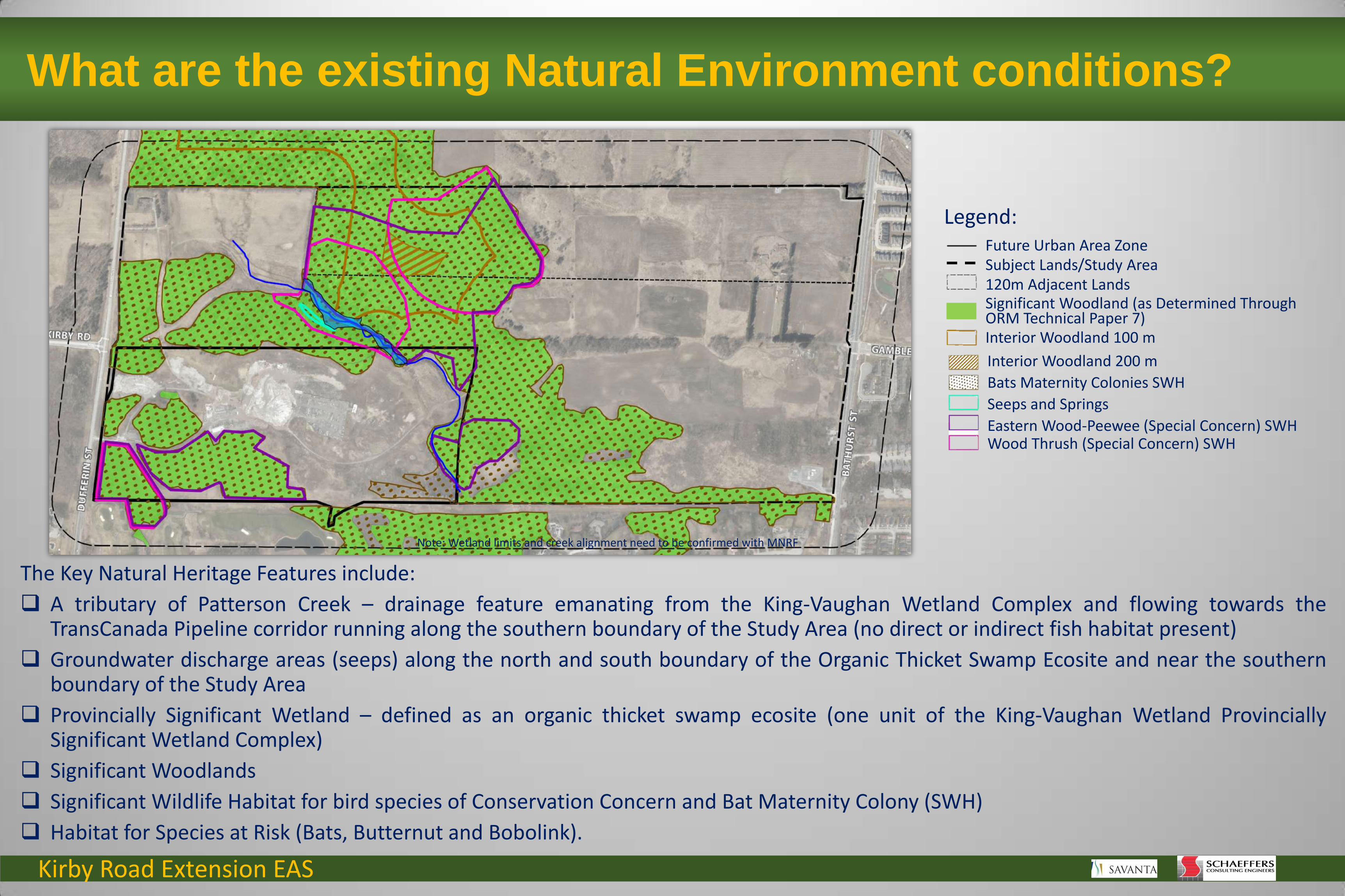
What are the existing Natural Environment conditions?
The Natural Heritage designated areas include:
The Oak Ridges Moraine Conservation Plan (ORMCP) area;
The Maple Spur Oak Ridges Moraine Regionally Significant Earth Science Area of Natural and Scientific Interest (ANSI) - the wooded areas associated with the western portion of the Study Area;
The Maple Spur Oak Ridges Moraine Provincially Significant Earth Science ANSI - the northern forested areas of the Study Area;
The Maple Uplands and Kettles Provincially Significant Life Science ANSI – most of the wooded areas within the Study Area.
The King-Vaughan Wetland Provincially Significant Wetland (PSW) Complex - Study Area includes one of the 23 wetland units mapped in this complex;
The McGill Area Environmentally Sensitive Area (ESA) that is designated by Toronto and Region Conservation Authority (TRCA) and includes the King-Vaughan Wetland Complex, Maple Uplands and Kettle Wetlands Life Science ANSI, Cook’s Area Life Science ANSI and the Maple Spur of the Oak Ridges Moraine Earth Science ANSI; and
Regional Greenlands as identified within the 2010 York Region Official Plan – the wooded areas within the Study Area.
Natural Core Area
Natural Linkage Area
Countryside Area
Settlement Area
ORM Land Use Designation
Maple Spur – ORM Earth Science, Regionally Significant Maple Spur – ORM Earth Science, Provincially Significant Maple Uplands and Kettles – Life Science, Provincially Significant
ANSI (MNRF LIO)
Study Area
Future Urban Area King-Vaughan wetland complex (MNR LIO)
Regional Greenlands (York OP, 2013)
ESA (TRCA)
Note: Wetland limits and creek alignment need to be confirmed with MNRF
Legend:
Kirby Road Extension EAS
The Key Natural Heritage Features include:
A tributary of Patterson Creek – drainage feature emanating from the King-Vaughan Wetland Complex and flowing towards the TransCanada Pipeline corridor running along the southern boundary of the Study Area (no direct or indirect fish habitat present)
Groundwater discharge areas (seeps) along the north and south boundary of the Organic Thicket Swamp Ecosite and near the southern boundary of the Study Area
Provincially Significant Wetland – defined as an organic thicket swamp ecosite (one unit of the King-Vaughan Wetland Provincially Significant Wetland Complex)
Significant Woodlands
Significant Wildlife Habitat for bird species of Conservation Concern and Bat Maternity Colony (SWH)
Habitat for Species at Risk (Bats, Butternut and Bobolink).
Note: Wetland limits and creek alignment need to be confirmed with MNRF
Future Urban Area Zone Subject Lands/Study Area 120m Adjacent Lands Significant Woodland (as Determined Through ORM Technical Paper 7) Interior Woodland 100 m
Interior Woodland 200 m
Bats Maternity Colonies SWH
Seeps and Springs
Eastern Wood-Peewee (Special Concern) SWH Wood Thrush (Special Concern) SWH
Legend:
What are the existing Natural Environment conditions?

Kirby Road Extension EAS
Social Environment – Policies Overview
The provincial, regional and local planning policies were considered in the evaluation of Alternative Design Concepts:
2014 Provincial Policy Statement (PPS)
Section 1.6.7.1 states: “Transportation systems should be provided which are safe, energy efficient, facilitate the movement of people and goods, and are appropriate to address projected needs.”
Any road alignment traversing the Study Area in east-west direction will cross significant environmental features. While Section 2.1 of the PPS prohibits development and site alterations in significant environmental features, (i.e., a Provincially Significant Wetland), Section 6 Definitions of the PPS defines “development” to exclude “activities that create or maintain infrastructure authorized under an environmental assessment process”.
The Study Area contains lands that have been identified as provincially significant Area of Natural and Scientific Interest (ANSI). The PPS only considers provincially significant ANSI as determined by the Ontario Ministry of Natural Resources and Forestry to be “significant”.
2017 Oak Ridges Moraine Conservation Plan (ORMCP)
Lands within the Study Area are designated Natural Core, Natural Linkage, and Countryside in the ORMCP. Infrastructure is only permitted in or on land in a Natural Core Area or Natural Linkage Area if there is a demonstrated need and there is no reasonable alternative. Both the York Region and City of Vaughan Master Transportation Plans confirmed the need to construct a 4-lane missing Kirby Road link. Transportation analysis conducted by the Project Team provided a consistent evaluation of alternatives and verified the need for the Kirby Road Extension.
The ORMCP requires that the right of way width and construction disturbance be kept to a minimum, the project will allow for wildlife movement, lighting is focused downward and away from Natural Core Areas, and the project is located as close to the edge of the Natural Core Area as possible.
The lands are also identified as Category 1 or Category 2 Landform Conservation Area. While Section 30 of the ORMCP serves to limit the impact of development and site alterations on existing landforms, the ORMCP defines “development” to exclude “activities that create or maintain infrastructure authorized under an environmental assessment process”.
2010 Region of York and City of Vaughan Official Plans
Both the Region and the City incorporate the policies of the ORMCP in their Official Plans.
Lands identified as Future Urban Area Zone in the southwest corner of the Study Area are subject to an order issued by the Minister of Municipal Affairs and Housing in February 2015.
The Minister’s Order amends the Region of York Official Plan to indicate that these lands are intended to be developed for urban uses.
The Minister’s Order amends the City of Vaughan Official Plan by designating the lands Low Density Residential and Valley and Stream Corridor. It also zones the property to Future Urban Area Zone permitting the development of Low Density Residential, Local Commercial, and Open Space uses.
The Study Area is comprised of 10 parcels of land and an unopened road allowance.
Existing land uses consist of 6 residences, a concrete recycling operation, agricultural uses, utility uses, and vacant/forested lands.
Existing ROW Concrete Recycling Agricultural Use Enbridge Gate Station
Note: Wetland limits and creek alignment need to be confirmed with MNRF
Kirby Road Extension EAS
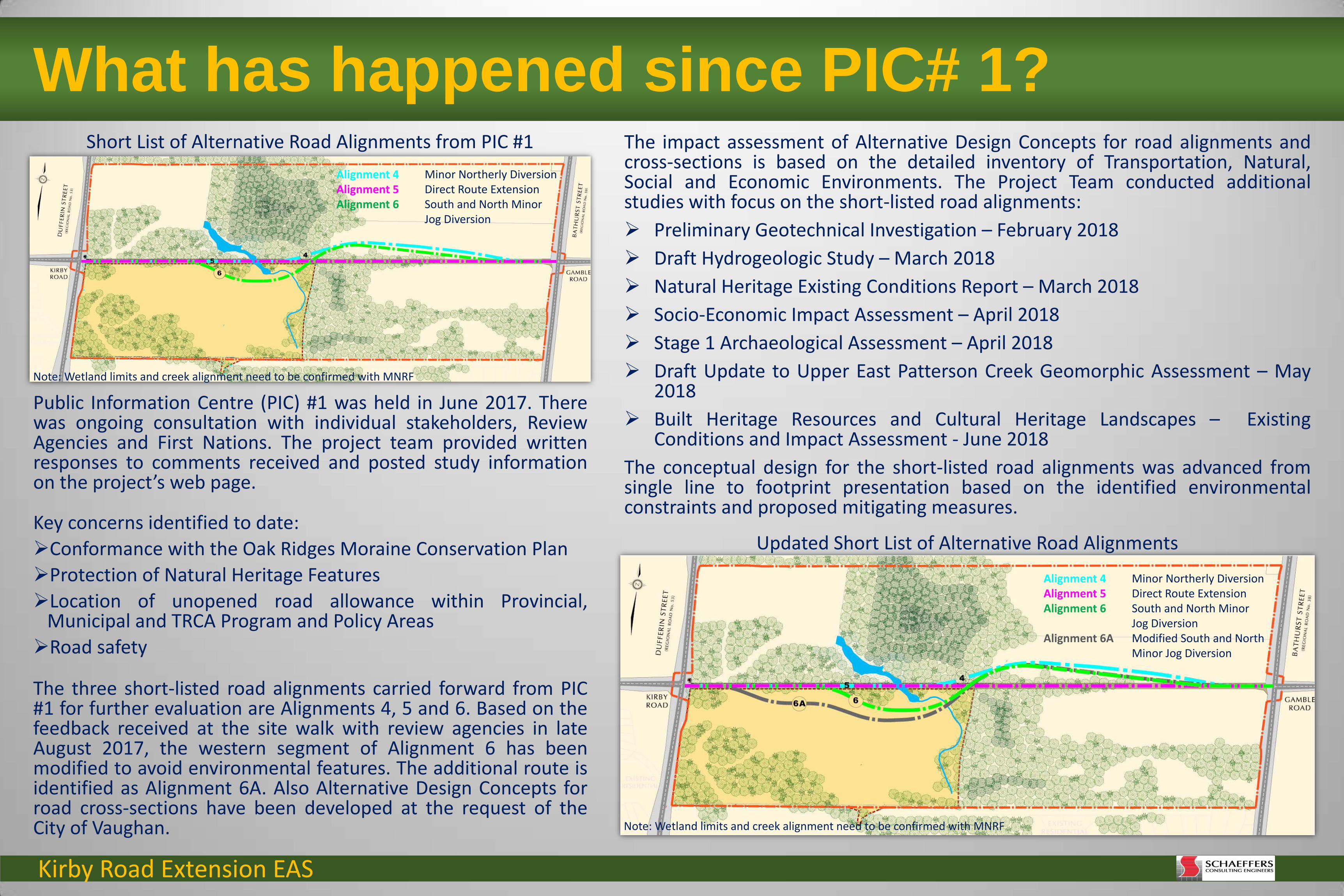
What has happened since PIC# 1? The impact assessment of Alternative Design Concepts for road alignments and cross-sections is based on the detailed inventory of Transportation, Natural, Social and Economic Environments. The Project Team conducted additional studies with focus on the short-listed road alignments:
Preliminary Geotechnical Investigation – February 2018
Draft Hydrogeologic Study – March 2018
Natural Heritage Existing Conditions Report – March 2018
Socio-Economic Impact Assessment – April 2018
Stage 1 Archaeological Assessment – April 2018
Draft Update to Upper East Patterson Creek Geomorphic Assessment – May 2018
Built Heritage Resources and Cultural Heritage Landscapes – Existing Conditions and Impact Assessment - June 2018
The conceptual design for the short-listed road alignments was advanced from single line to footprint presentation based on the identified environmental constraints and proposed mitigating measures.
Public Information Centre (PIC) #1 was held in June 2017. There was ongoing consultation with individual stakeholders, Review Agencies and First Nations. The project team provided written responses to comments received and posted study information on the project’s web page.
Key concerns identified to date:
Conformance with the Oak Ridges Moraine Conservation Plan
Protection of Natural Heritage Features
Location of unopened road allowance within Provincial, Municipal and TRCA Program and Policy Areas
Road safety
The three short-listed road alignments carried forward from PIC #1 for further evaluation are Alignments 4, 5 and 6. Based on the feedback received at the site walk with review agencies in late August 2017, the western segment of Alignment 6 has been modified to avoid environmental features. The additional route is identified as Alignment 6A. Also Alternative Design Concepts for road cross-sections have been developed at the request of the City of Vaughan. Note: Wetland limits and creek alignment need to be confirmed with MNRF
Updated Short List of Alternative Road Alignments
Short List of Alternative Road Alignments from PIC #1
Note: Wetland limits and creek alignment need to be confirmed with MNRF
Alignment 4 Minor Northerly Diversion Alignment 5 Direct Route Extension Alignment 6 South and North Minor
Jog Diversion Alignment 6A Modified South and North
Minor Jog Diversion
Alignment 4 Minor Northerly Diversion Alignment 5 Direct Route Extension Alignment 6 South and North Minor
Jog Diversion
Kirby Road Extension EAS
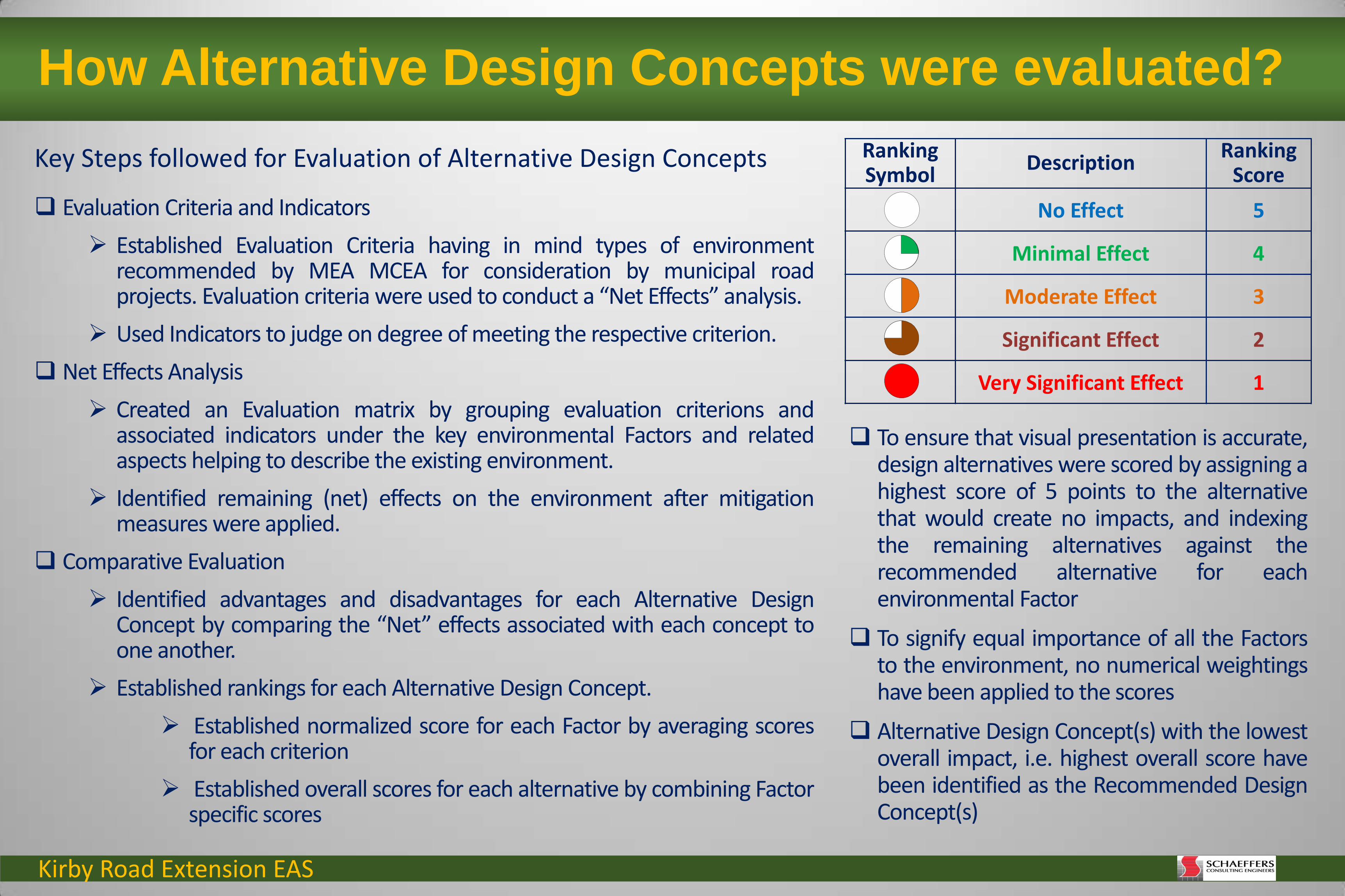
How Alternative Design Concepts were evaluated?
Key Steps followed for Evaluation of Alternative Design Concepts
Evaluation Criteria and Indicators
Established Evaluation Criteria having in mind types of environment recommended by MEA MCEA for consideration by municipal road projects. Evaluation criteria were used to conduct a “Net Effects” analysis.
Used Indicators to judge on degree of meeting the respective criterion.
Net Effects Analysis
Created an Evaluation matrix by grouping evaluation criterions and associated indicators under the key environmental Factors and related aspects helping to describe the existing environment.
Identified remaining (net) effects on the environment after mitigation measures were applied.
Comparative Evaluation
Identified advantages and disadvantages for each Alternative Design Concept by comparing the “Net” effects associated with each concept to one another.
Established rankings for each Alternative Design Concept.
Established normalized score for each Factor by averaging scores for each criterion
Established overall scores for each alternative by combining Factor specific scores
Ranking Symbol
Description Ranking
Score
No Effect 5
Minimal Effect 4
Moderate Effect 3
Significant Effect 2
Very Significant Effect 1
To ensure that visual presentation is accurate, design alternatives were scored by assigning a highest score of 5 points to the alternative that would create no impacts, and indexing the remaining alternatives against the recommended alternative for each environmental Factor
To signify equal importance of all the Factors to the environment, no numerical weightings have been applied to the scores
Alternative Design Concept(s) with the lowest overall impact, i.e. highest overall score have been identified as the Recommended Design Concept(s)
Kirby Road Extension EAS
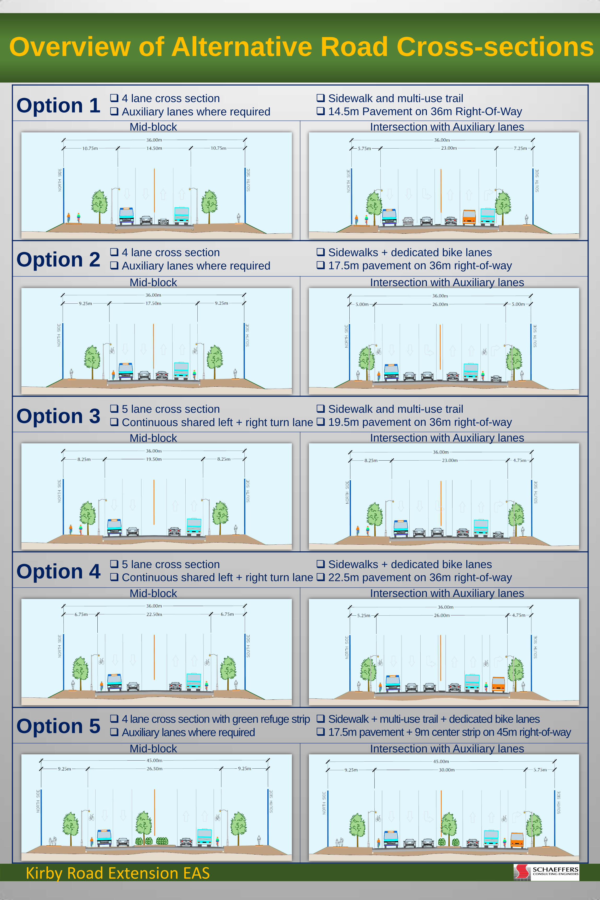
Overview of Alternative Road Cross-sections
4 lane cross section
Auxiliary lanes where required Option 1
4 lane cross section
Auxiliary lanes where required
5 lane cross section
Continuous shared left + right turn lane
5 lane cross section Continuous shared left + right turn lane
Sidewalk + multi-use trail + dedicated bike lanes 17.5m pavement + 9m center strip on 45m right-of-way
Option 2
Option 3
Option 5
Option 4
Sidewalk and multi-use trail 14.5m Pavement on 36m Right-Of-Way
Sidewalk and multi-use trail 19.5m pavement on 36m right-of-way
Sidewalks + dedicated bike lanes 22.5m pavement on 36m right-of-way
4 lane cross section with green refuge strip
Auxiliary lanes where required
Sidewalks + dedicated bike lanes 17.5m pavement on 36m right-of-way
Mid-block Intersection with Auxiliary lanes
Mid-block
Mid-block
Mid-block
Mid-block
Intersection with Auxiliary lanes
Intersection with Auxiliary lanes
Intersection with Auxiliary lanes
Intersection with Auxiliary lanes

Kirby Road Extension EAS
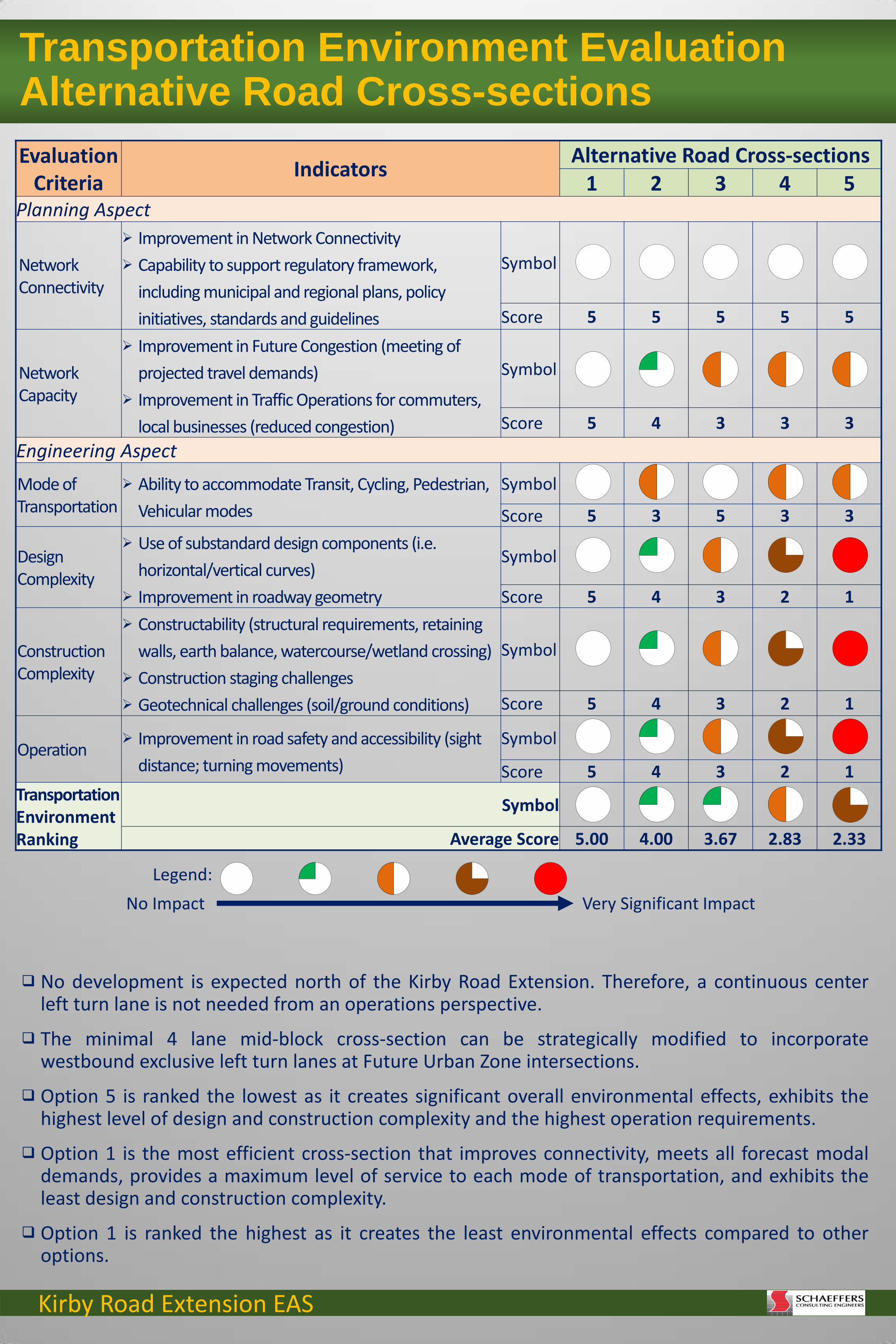
Natural Environment Evaluation Alternative Road Cross-sections
Evaluation Criteria
Indicators Alternative Road Cross-sections
1 2 3 4 5 Terrestrial Features Aspect
Wetlands Effects on Provincially Significant Wetland and other
wetlands Symbol
Score 5 4 2 1 3
Vegetation
Encroachment on Designated Environmentally Sensitive Areas / Areas of Natural and Scientific Interest
Effects on Significant Terrestrial Features (encroachment, reduction of area)
Fragmentation/Connectivity of features Species at Risk (rare, endangered and threatened) Opportunities for enhancement
Symbol
Score 5 4 2 1 3
Wildlife Habitat
Effects on Significant Wildlife Habitat (encroachment, reduction of area)
Fragmentation/Connectivity of features Species at Risk (rare, endangered and threatened) Opportunities for enhancement
Symbol
Score 5 5 5 5 1
Aquatic Features Aspect Surface Water Quantity and Quality
Degree of interference with water quality, thermal regime or baseflow
Symbol
Score 5 4 2 1 3
Aquatic Habitat
Effects on extent (area) and function of riparian habitat
Symbol
Score 5 5 5 5 1
Surface Drainage Aspect
Watercourses Requirements for crossing of East Patterson Creek
(reduction of area) Symbol
Score 5 5 5 5 1
Stormwater Management
Effects on catchment area Operation and maintenance requirements
Symbol
Score 5 4 3 2 1
Groundwater Aspect
Recharge Areas
Degree of interference with groundwater recharge/discharge areas
Symbol
Score 5 5 5 5 5
Groundwater Quality
Effects on vulnerable areas Symbol
Score 5 5 5 5 5 Natural Environment Ranking
Symbol
Average Score 5.00 4.56 3.78 3.33 2.56
Option 1 has the least amount of impact to the wetlands, woodlands/wildlife habitat and surface water quality as it has the least amount of impervious pavement and is the preferred ROW width of 36m.
Option 5 will result in the most impacts to adjacent woodlands/wildlife habitat and wetland due to the wider road ROW width of 45 m.
All Options affect the watercourses equally except for Option 5 which will have greater impacts due to the wider road ROW width of 45 m.
Option 1 will result in the least amount of impact to stormwater management whereas Option 5 will result in the most. Option 1 is ranked the highest as it will result in the least amount of encroachment into adjacent natural heritage
features (36 m) and has the least amount of impervious surface area (pavement). Option 5 is ranked the lowest as it will result in the greatest amount of encroachment into adjacent natural heritage
features (45 m).
No Impact Very Significant Impact
Legend:
Kirby Road Extension EAS
Evaluation Criteria
Indicators Alternative Road Cross-sections
1 2 3 4 5 Planning Aspect
Network Connectivity
Improvement in Network Connectivity
Capability to support regulatory framework,
including municipal and regional plans, policy
initiatives, standards and guidelines
Symbol
Score 5 5 5 5 5
Network Capacity
Improvement in Future Congestion (meeting of
projected travel demands)
Improvement in Traffic Operations for commuters,
local businesses (reduced congestion)
Symbol
Score 5 4 3 3 3
Engineering Aspect
Mode of Transportation
Ability to accommodate Transit, Cycling, Pedestrian,
Vehicular modes
Symbol
Score 5 3 5 3 3
Design Complexity
Use of substandard design components (i.e.
horizontal/vertical curves)
Improvement in roadway geometry
Symbol
Score 5 4 3 2 1
Construction Complexity
Constructability (structural requirements, retaining
walls, earth balance, watercourse/wetland crossing)
Construction staging challenges
Geotechnical challenges (soil/ground conditions)
Symbol
Score 5 4 3 2 1
Operation Improvement in road safety and accessibility (sight
distance; turning movements)
Symbol
Score 5 4 3 2 1 Transportation Environment Ranking
Symbol
Average Score 5.00 4.00 3.67 2.83 2.33
Transportation Environment Evaluation Alternative Road Cross-sections
No development is expected north of the Kirby Road Extension. Therefore, a continuous center left turn lane is not needed from an operations perspective.
The minimal 4 lane mid-block cross-section can be strategically modified to incorporate westbound exclusive left turn lanes at Future Urban Zone intersections.
Option 5 is ranked the lowest as it creates significant overall environmental effects, exhibits the highest level of design and construction complexity and the highest operation requirements.
Option 1 is the most efficient cross-section that improves connectivity, meets all forecast modal demands, provides a maximum level of service to each mode of transportation, and exhibits the least design and construction complexity.
Option 1 is ranked the highest as it creates the least environmental effects compared to other options.
No Impact Very Significant Impact
Legend:

Kirby Road Extension EAS
Evaluation Criteria
Indicators Alternative Road Cross-sections
1 2 3 4 5 Land Use Aspect Resource Designations and Policies
Degree of compatibility with provincial, regional and
municipal growth/development goals/objectives
Symbol
Score 5 5 5 5 1
Agricultural Operations
Physical resource consumption
Facility resource consumption
Operational impacts
Symbol
Score 5 5 5 5 1
Approved Development Proposals
Accommodating existing/future development
proposals (public access/intersecting
streets/connections for all modes of transportation)
Symbol
Score 5 5 5 5 1
Community Aspect
Quality of Life
Encroachment on individual properties
(number/area)
Improvement in traffic operations for commuters and
active transportation
Symbol
Score 5 5 5 5 1
Existing Wells Effects on water quality and quantity
Number of affected wells
Symbol
Score 5 5 5 5 5
Noise Change in sound levels over pre-existing conditions Symbol
Score 5 5 5 5 5
Cultural Aspect
Archaeological Resources
Degree of interference with known areas of
archaeological potential
Symbol
Score 2 2 2 2 1
Built Heritage Resources
Degree of interference with cultural heritage features Symbol
Score 2 2 2 2 1 Social Environment Ranking
Symbol
Average Score 4.25 4.25 4.25 4.25 2.00
Social Environment Evaluation Alternative Road Cross-sections
Options 1 - 4 propose a road allowance width of 36 m.
Option 5 proposes a road allowance width of 45 m.
The social effects of Option 1 – 4 do not differ amongst these options.
The social effect of Option 5 is greater than Options 1 - 4 due to its larger footprint, which results in a greater impact on existing environmental features, agricultural operations, approved development proposals and the amount of private land that must be acquired.
Options 1 - 4 are ranked equally and Option 5 is ranked the lowest as it requires more Stage 2 archaeological survey, includes the widest grading limit and poses very significant impacts to the identified cultural farmscape.
No Impact Very Significant Impact
Legend:

Kirby Road Extension EAS
Natural Environment Impact Assessment Alternative Road Alignments
Significant impact to PSW and riparian area – direct removal of riparian wetland vegetation.
Significant impact to and direct removal of woodlands which provide Significant Wildlife Habitat (SWH) for Species of Conservation Concern and bats – 5.62 ha along 933 m of alignment.
Moderate impact to habitat for Species at Risk. Moderate impact to East Patterson Creek.
Significant impact to PSW and riparian area – direct removal of riparian wetland vegetation.
Most significant impact to and direct removal of woodlands which provide Significant Wildlife Habitat (SWH) for Species of Conservation Concern and bats – 7.13 ha along 1069 m of alignment.
Significant impact to habitat for Species at Risk. Moderate impact to East Patterson Creek.
Moderate impact to PSW and riparian area – direct removal of riparian wetland vegetation.
Minimal impact to and direct removal of woodlands (primarily edge effect) which provide Significant Wildlife Habitat (SWH) for Species of Conservation Concern and bats – 4.63 ha along 661 m of alignment.
Moderate impact to habitat for Species at Risk. Minimal impact to East Patterson Creek.
Minimal impact to PSW and wetland riparian area – no direct removal of riparian vegetation.
Least impact to woodlands which provide Significant Wildlife Habitat (SWH) for Species of Conservation Concern and bats – least amount of removal, 3.83 ha along 274 m of alignment.
Moderate impact to habitat for Species at Risk. Minimal impact to East Patterson Creek.
Alignment 4 Minor Northerly Diversion
Alignment 5 Direct Route Extension
Alignment 6 South and North Minor Jog Diversion
Alignment 6A Modified South and North Minor Jog Diversion
Note: Wetland limits and creek alignment need to be confirmed with MNRF
Note: Wetland limits and creek alignment need to be confirmed with MNRF
Note: Wetland limits and creek alignment need to be confirmed with MNRF
Note: Wetland limits and creek alignment need to be confirmed with MNRF
Future Urban Area Zone Subject Lands/Study Area 120m Adjacent Lands Significant Woodland (as Determined Through ORM Technical Paper 7) Interior Woodland 200 m
Interior Woodland 100 m
Bats Maternity Colonies SWH
Seeps and Springs
Eastern Wood-Peewee (Special Concern) SWH Wood Thrush (Special Concern) SWH
Legend:

Kirby Road Extension EAS
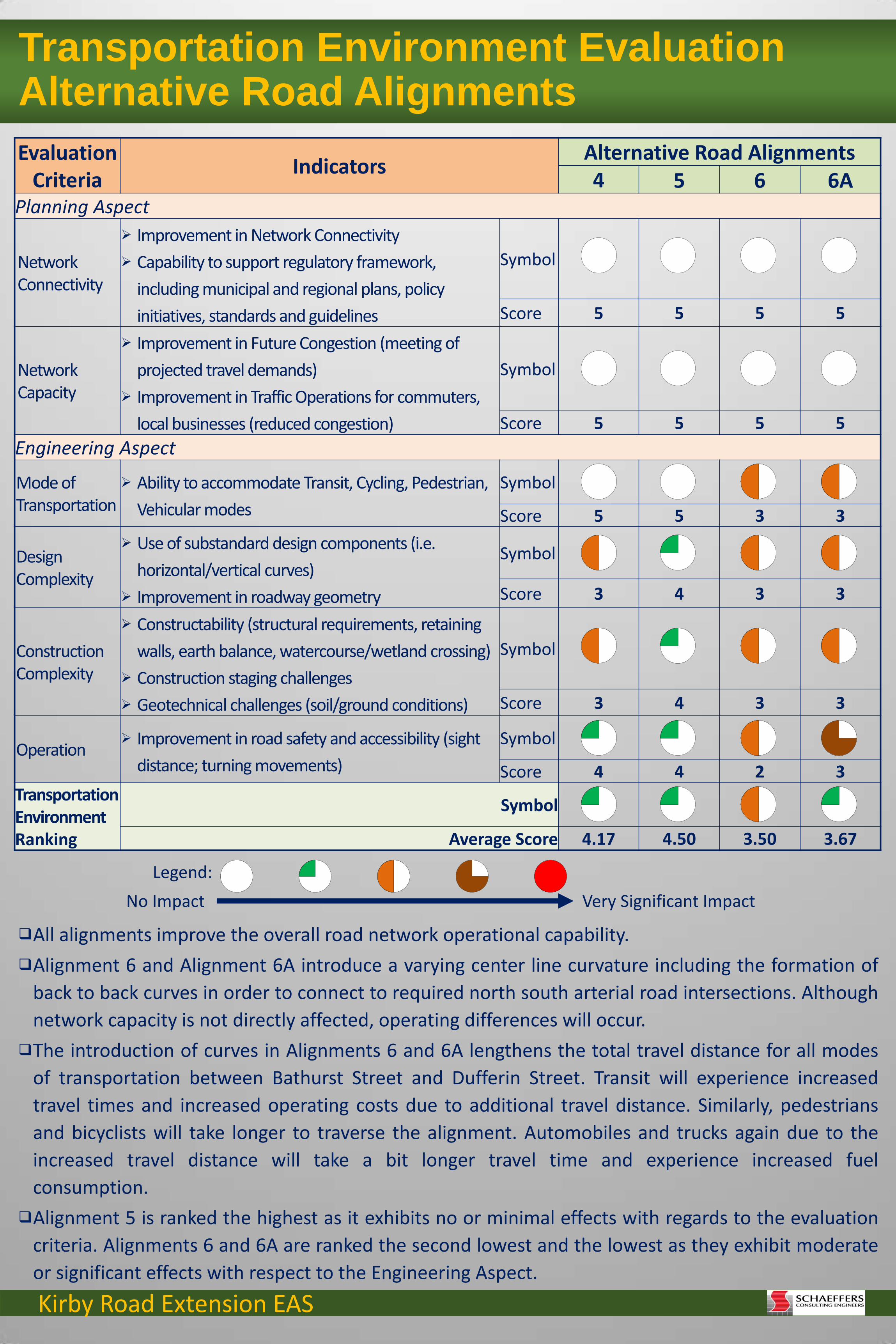
Natural Environment Evaluation Alternative Road Alignments Evaluation
Criteria Indicators
Alternative Road Alignments 4 5 6 6A
Terrestrial Features Aspect
Wetlands Effects on Provincially Significant Wetland and other
wetlands Symbol
Score 2 2 3 4
Vegetation
Encroachment on Designated Environmentally Sensitive Areas / Areas of Natural and Scientific Interest
Effects on Significant Terrestrial Features (encroachment, reduction of area)
Fragmentation/Connectivity of features Species at Risk (rare, endangered and threatened) Opportunities for enhancement
Symbol
Score 2 1 3 4
Wildlife Habitat
Effects on Significant Wildlife Habitat (encroachment, reduction of area)
Fragmentation/Connectivity of features Species at Risk (rare, endangered and threatened) Opportunities for enhancement
Symbol
Score 2 1 3 3
Aquatic Features Aspect Surface Water Quantity and Quality
Degree of interference with water quality, thermal regime or baseflow
Symbol
Score 3 3 4 4
Aquatic Habitat
Effects on extent (area) and function of riparian habitat
Symbol
Score 5 5 4 4
Surface Drainage Aspect
Watercourses Requirements for crossing of East Patterson Creek
(reduction of area) Symbol
Score 3 3 4 4
Stormwater Management
Effects on catchment area Operation and maintenance requirements
Symbol
Score 4 5 3 3
Groundwater Aspect
Recharge Areas
Degree of interference with groundwater recharge/discharge areas
Symbol
Score 3 3 4 4
Groundwater Quality
Effects on vulnerable areas Symbol
Score 5 5 5 5 Natural Environment Ranking
Symbol
Average Score 3.22 3.11 3.67 3.89
Alignment 5 will result in the most amount of impact to woodlands and wildlife habitat and a moderate impact to the wetland whereas alignment 6A will result in the least amount of impact to these features and a minimal impact to the wetland.
Alignments 4 and 5 will result in similar (moderate) impacts to surface water quality and no effects to aquatic habitat and Alignments 6 and 6A will result in less impacts to surface water quantity and quality and minimal effects to aquatic habitat.
Alignments 4 and 5 will result in moderate impacts to the watercourse and recharge/discharge areas and minimal impacts to stormwater management.
Alignments 6 and 6A will result in the least amount of impact to the watercourse and recharge/discharge areas and moderate impacts to stormwater management.
No impact to groundwater quality is anticipated with all of the proposed alignments. Alignment 5 is ranked the lowest as it will result in the greatest amount of removal of woodlands and encroaches
within PSW riparian areas. Alignment 6A is ranked the highest as it avoids most woodlands , the PSW and associated riparian area.
No Impact Very Significant Impact
Legend:
Kirby Road Extension EAS
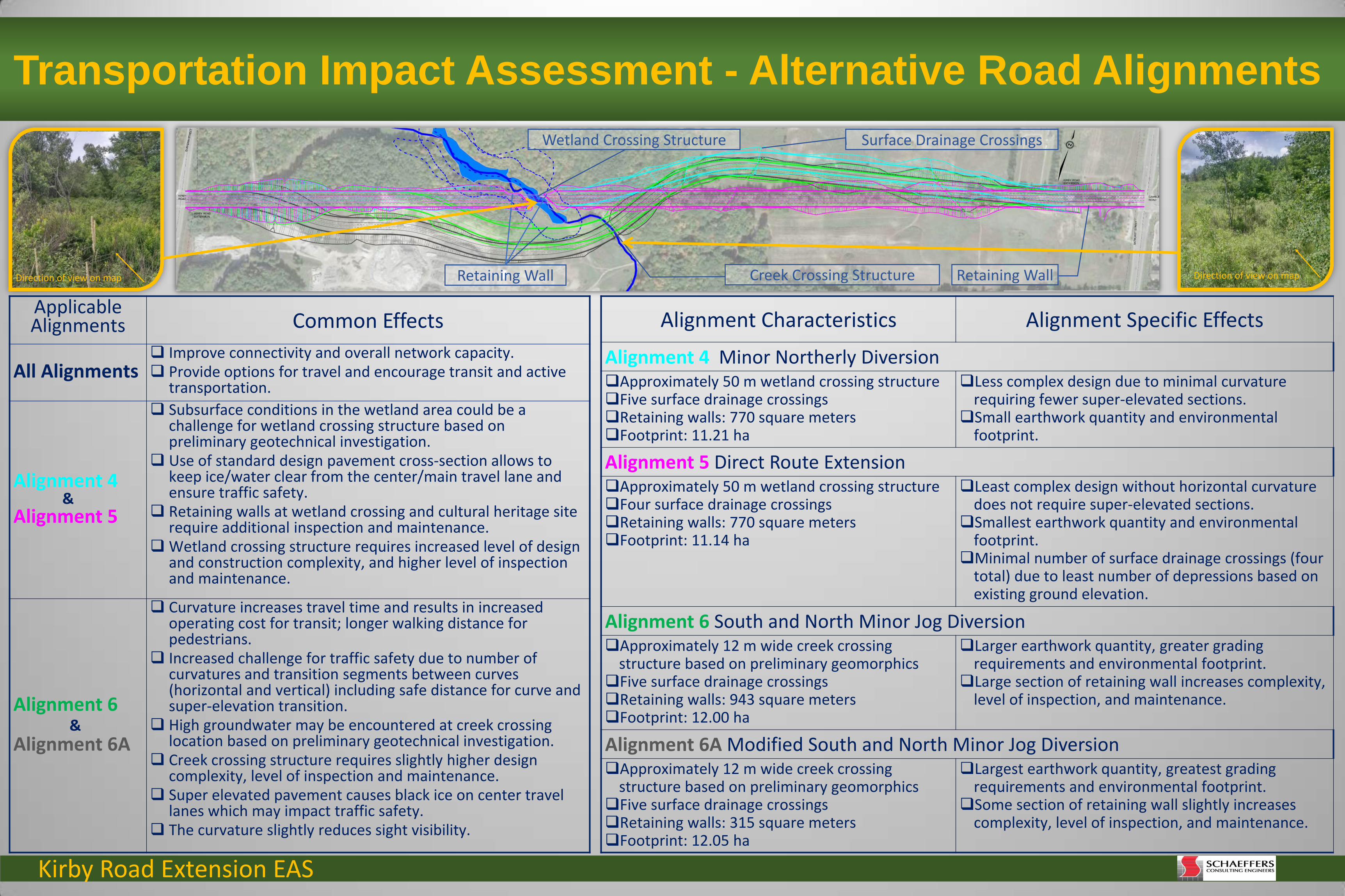
Transportation Impact Assessment - Alternative Road Alignments
Wetland Crossing Structure Surface Drainage Crossings
Retaining Wall Creek Crossing Structure Retaining Wall Direction of view on map Direction of view on map
Applicable Alignments Common Effects
All Alignments Improve connectivity and overall network capacity. Provide options for travel and encourage transit and active
transportation.
Alignment 4 & Alignment 5
Subsurface conditions in the wetland area could be a challenge for wetland crossing structure based on preliminary geotechnical investigation.
Use of standard design pavement cross-section allows to keep ice/water clear from the center/main travel lane and ensure traffic safety.
Retaining walls at wetland crossing and cultural heritage site require additional inspection and maintenance.
Wetland crossing structure requires increased level of design and construction complexity, and higher level of inspection and maintenance.
Alignment 6 & Alignment 6A
Curvature increases travel time and results in increased operating cost for transit; longer walking distance for pedestrians.
Increased challenge for traffic safety due to number of curvatures and transition segments between curves (horizontal and vertical) including safe distance for curve and super-elevation transition.
High groundwater may be encountered at creek crossing location based on preliminary geotechnical investigation.
Creek crossing structure requires slightly higher design complexity, level of inspection and maintenance.
Super elevated pavement causes black ice on center travel lanes which may impact traffic safety.
The curvature slightly reduces sight visibility.
Alignment Characteristics Alignment Specific Effects
Alignment 4 Minor Northerly Diversion Approximately 50 m wetland crossing structure Five surface drainage crossings Retaining walls: 770 square meters Footprint: 11.21 ha
Less complex design due to minimal curvature requiring fewer super-elevated sections.
Small earthwork quantity and environmental footprint.
Alignment 5 Direct Route Extension Approximately 50 m wetland crossing structure Four surface drainage crossings Retaining walls: 770 square meters Footprint: 11.14 ha
Least complex design without horizontal curvature does not require super-elevated sections.
Smallest earthwork quantity and environmental footprint.
Minimal number of surface drainage crossings (four total) due to least number of depressions based on existing ground elevation.
Alignment 6 South and North Minor Jog Diversion Approximately 12 m wide creek crossing
structure based on preliminary geomorphics Five surface drainage crossings Retaining walls: 943 square meters Footprint: 12.00 ha
Larger earthwork quantity, greater grading requirements and environmental footprint.
Large section of retaining wall increases complexity, level of inspection, and maintenance.
Alignment 6A Modified South and North Minor Jog Diversion Approximately 12 m wide creek crossing
structure based on preliminary geomorphics Five surface drainage crossings Retaining walls: 315 square meters Footprint: 12.05 ha
Largest earthwork quantity, greatest grading requirements and environmental footprint.
Some section of retaining wall slightly increases complexity, level of inspection, and maintenance.
Kirby Road Extension EAS
Evaluation Criteria
Indicators Alternative Road Alignments 4 5 6 6A
Planning Aspect
Network Connectivity
Improvement in Network Connectivity
Capability to support regulatory framework,
including municipal and regional plans, policy
initiatives, standards and guidelines
Symbol
Score 5 5 5 5
Network Capacity
Improvement in Future Congestion (meeting of
projected travel demands)
Improvement in Traffic Operations for commuters,
local businesses (reduced congestion)
Symbol
Score 5 5 5 5
Engineering Aspect
Mode of Transportation
Ability to accommodate Transit, Cycling, Pedestrian,
Vehicular modes
Symbol
Score 5 5 3 3
Design Complexity
Use of substandard design components (i.e.
horizontal/vertical curves)
Improvement in roadway geometry
Symbol
Score 3 4 3 3
Construction Complexity
Constructability (structural requirements, retaining
walls, earth balance, watercourse/wetland crossing)
Construction staging challenges
Geotechnical challenges (soil/ground conditions)
Symbol
Score 3 4 3 3
Operation Improvement in road safety and accessibility (sight
distance; turning movements)
Symbol
Score 4 4 2 3 Transportation Environment Ranking
Symbol
Average Score 4.17 4.50 3.50 3.67
Transportation Environment Evaluation Alternative Road Alignments
All alignments improve the overall road network operational capability.
Alignment 6 and Alignment 6A introduce a varying center line curvature including the formation of
back to back curves in order to connect to required north south arterial road intersections. Although
network capacity is not directly affected, operating differences will occur.
The introduction of curves in Alignments 6 and 6A lengthens the total travel distance for all modes
of transportation between Bathurst Street and Dufferin Street. Transit will experience increased
travel times and increased operating costs due to additional travel distance. Similarly, pedestrians
and bicyclists will take longer to traverse the alignment. Automobiles and trucks again due to the
increased travel distance will take a bit longer travel time and experience increased fuel
consumption.
Alignment 5 is ranked the highest as it exhibits no or minimal effects with regards to the evaluation
criteria. Alignments 6 and 6A are ranked the second lowest and the lowest as they exhibit moderate
or significant effects with respect to the Engineering Aspect.
No Impact Very Significant Impact
Legend:
Kirby Road Extension EAS
Note: Wetland limits and creek alignment need to be confirmed with MNRF
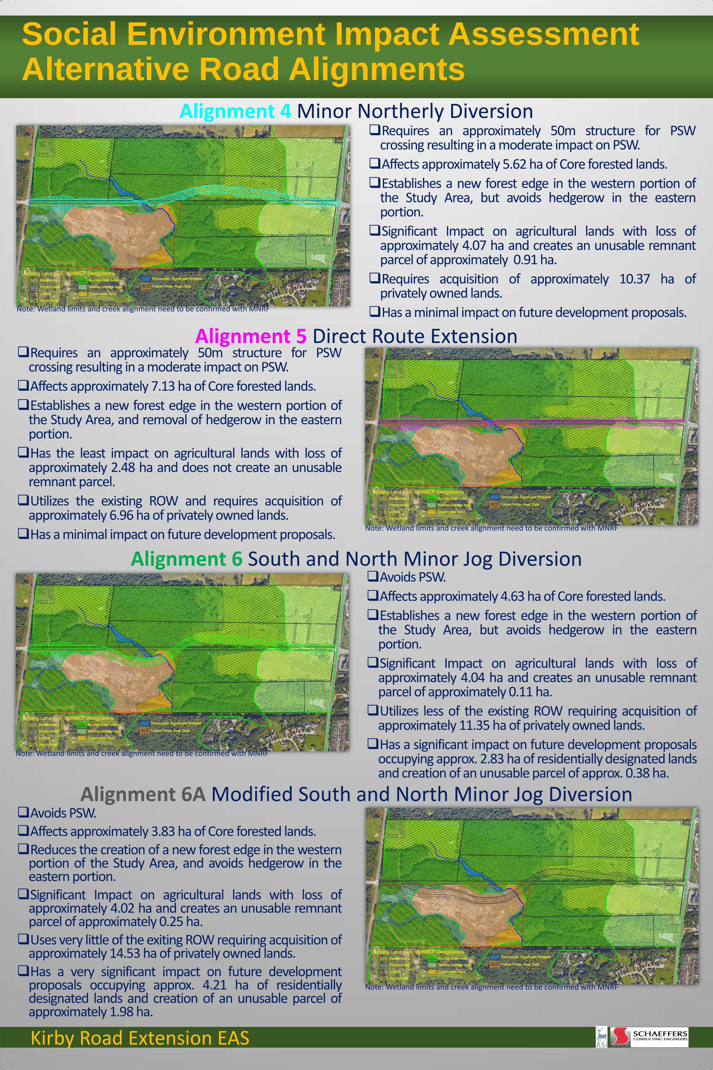
Social Environment Impact Assessment Alternative Road Alignments
Requires an approximately 50m structure for PSW crossing resulting in a moderate impact on PSW.
Affects approximately 5.62 ha of Core forested lands.
Establishes a new forest edge in the western portion of the Study Area, but avoids hedgerow in the eastern portion.
Significant Impact on agricultural lands with loss of approximately 4.07 ha and creates an unusable remnant parcel of approximately 0.91 ha.
Requires acquisition of approximately 10.37 ha of privately owned lands.
Has a minimal impact on future development proposals.
Requires an approximately 50m structure for PSW crossing resulting in a moderate impact on PSW.
Affects approximately 7.13 ha of Core forested lands.
Establishes a new forest edge in the western portion of the Study Area, and removal of hedgerow in the eastern portion.
Has the least impact on agricultural lands with loss of approximately 2.48 ha and does not create an unusable remnant parcel.
Utilizes the existing ROW and requires acquisition of approximately 6.96 ha of privately owned lands.
Has a minimal impact on future development proposals.
Avoids PSW.
Affects approximately 4.63 ha of Core forested lands.
Establishes a new forest edge in the western portion of the Study Area, but avoids hedgerow in the eastern portion.
Significant Impact on agricultural lands with loss of approximately 4.04 ha and creates an unusable remnant parcel of approximately 0.11 ha.
Utilizes less of the existing ROW requiring acquisition of approximately 11.35 ha of privately owned lands.
Has a significant impact on future development proposals occupying approx. 2.83 ha of residentially designated lands and creation of an unusable parcel of approx. 0.38 ha.
Avoids PSW. Affects approximately 3.83 ha of Core forested lands. Reduces the creation of a new forest edge in the western
portion of the Study Area, and avoids hedgerow in the eastern portion.
Significant Impact on agricultural lands with loss of approximately 4.02 ha and creates an unusable remnant parcel of approximately 0.25 ha.
Uses very little of the exiting ROW requiring acquisition of approximately 14.53 ha of privately owned lands.
Has a very significant impact on future development proposals occupying approx. 4.21 ha of residentially designated lands and creation of an unusable parcel of approximately 1.98 ha.
Alignment 4 Minor Northerly Diversion
Alignment 5 Direct Route Extension
Alignment 6 South and North Minor Jog Diversion
Alignment 6A Modified South and North Minor Jog Diversion
Note: Wetland limits and creek alignment need to be confirmed with MNRF
Note: Wetland limits and creek alignment need to be confirmed with MNRF
Note: Wetland limits and creek alignment need to be confirmed with MNRF

Kirby Road Extension EAS
Archeological and Cultural Heritage Impact Assessment Alternative Road Alignments
Archeological Effects
All routes cross the areas of archaeological potential.
Alignments 6 and 6A cross disturbed area which reduces potential for findings.
Alignment 5 ranked the lowest as it exhibits highest potential for findings.
Alignment 6A ranked the highest as it exhibits lowest potential for findings.
Cultural Heritage Effects
City of Vaughan has listed one property within the Study Area to be of cultural heritage interest, but it has not been officially identified.
All alignments have an effect on the house which is mitigated by introduction of a retaining wall.
Alignments 4, 6 and 6A avoid the Cultural Heritage Landscape of interest.
Alignment 5 ranked lower than other alignments as it encroaches more into the Cultural Heritage Landscape than the other 3 alignments.
Property of Heritage Interest
CHL 1

Kirby Road Extension EAS
Evaluation Criteria
Indicators Alternative Road Alignments 4 5 6 6A
Land Use Aspect Resource Designations and Policies
Degree of compatibility with provincial, regional and municipal growth/development goals/objectives
Symbol
Score 3 2 4 4
Agricultural Operations
Physical resource consumption Facility resource consumption Operational impacts
Symbol
Score 2 5 2 2
Approved Development Proposals
Accommodating existing/future development proposals (public access/intersecting streets/connections for all modes of transportation)
Symbol
Score 5 5 2 1
Community Aspect
Quality of Life
Encroachment on individual properties (number/area)
Improvement in traffic operations for commuters and active transportation
Symbol
Score 3 4 2 1
Existing Wells Effects on water quality and quantity
Number of affected wells
Symbol
Score 5 5 5 5
Noise Change in sound levels over pre-existing conditions Symbol
Score 5 5 5 5
Cultural Aspect
Archaeological Resources
Degree of interference with known areas of archaeological potential
Symbol
Score 1 1 2 3
Built Heritage Resources
Degree of interference with cultural heritage features Symbol
Score 3 2 3 3 Social Environment Ranking
Symbol
Average Score 3.38 3.63 3.13 3.00
Social Environment Evaluation Alternative Road Alignments
Alignments 4 and 5 are the same except Alignment 4 avoids the hedgerow located in the existing ROW in the eastern portion of the Study Area and as a result, Alignment 4 has a significant impact on agricultural lands.
Alignment 5, which uses all of the existing ROW has the least impact on existing and approved land uses and requires the acquisition of the least amount of privately owned lands.
Alignments 6 and 6A have the least impact on existing environmental features and the greatest impact on existing and approved land uses
Alignments 6 has a significant impact on privately owned lands requiring the acquisition of approximately 11.35 ha of land including approximately 3.21 ha of lands designated for residential development.
Alignment 6A has a very significant impact on privately owned lands requiring the acquisition of approximately 14.53 ha of land including approximately 6.19 ha of lands designated for residential development.
From a cultural perspective, Alignments 6 and 6A are preferred over Alignments 4 and 5 as they interfere to lesser degree with areas of known archaeological potential.
Alignments 4, 6 and 6A would have moderate direct impacts on one previously identified cultural heritage resource of interest (11490 Bathurst St., farmhouse).
Alignment 5 would have a more significant direct impact to one previously identified cultural heritage resource of interest (11490 Bathurst St., farmscape).
Overall, Alignment 5 is ranked the highest and Alignment 6A is ranked the lowest.
No Impact Very Significant Impact
Legend:
Kirby Road Extension EAS
Evaluation Criteria
Indicators Alternative Road Cross-sections
1 2 3 4 5
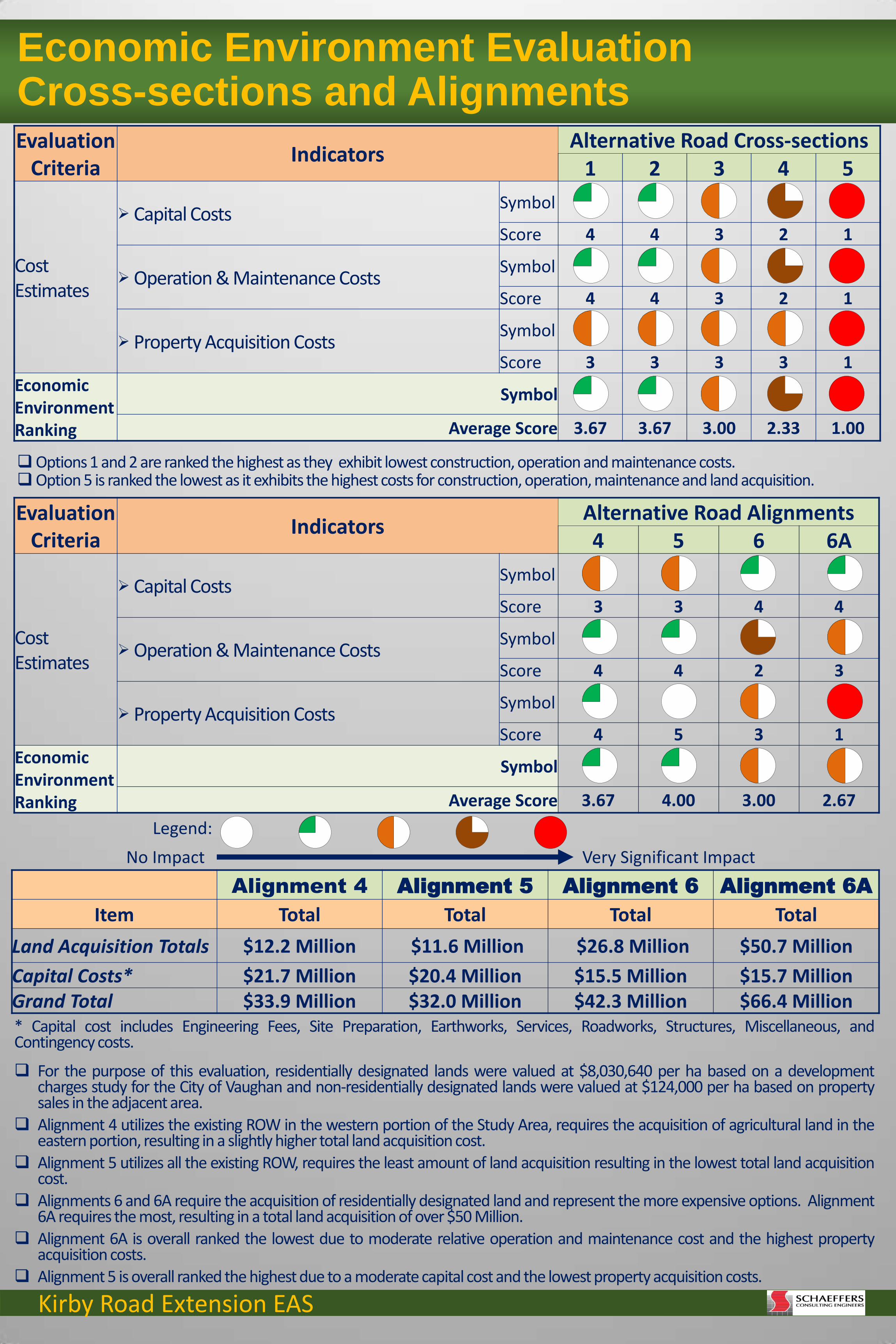
Cost Estimates
Capital Costs Symbol
Score 4 4 3 2 1
Operation & Maintenance Costs Symbol
Score 4 4 3 2 1
Property Acquisition Costs Symbol
Score 3 3 3 3 1 Economic Environment Ranking
Symbol
Average Score 3.67 3.67 3.00 2.33 1.00
Evaluation Criteria
Indicators Alternative Road Alignments 4 5 6 6A
Cost Estimates
Capital Costs Symbol
Score 3 3 4 4
Operation & Maintenance Costs Symbol
Score 4 4 2 3
Property Acquisition Costs Symbol
Score 4 5 3 1 Economic Environment Ranking
Symbol
Average Score 3.67 4.00 3.00 2.67
Economic Environment Evaluation Cross-sections and Alignments
Alignment 4 Alignment 5 Alignment 6 Alignment 6A
Item Total Total Total Total
Land Acquisition Totals $12.2 Million $11.6 Million $26.8 Million $50.7 Million
Capital Costs* $21.7 Million $20.4 Million $15.5 Million $15.7 Million Grand Total $33.9 Million $32.0 Million $42.3 Million $66.4 Million * Capital cost includes Engineering Fees, Site Preparation, Earthworks, Services, Roadworks, Structures, Miscellaneous, and Contingency costs.
For the purpose of this evaluation, residentially designated lands were valued at $8,030,640 per ha based on a development charges study for the City of Vaughan and non-residentially designated lands were valued at $124,000 per ha based on property sales in the adjacent area.
Alignment 4 utilizes the existing ROW in the western portion of the Study Area, requires the acquisition of agricultural land in the eastern portion, resulting in a slightly higher total land acquisition cost.
Alignment 5 utilizes all the existing ROW, requires the least amount of land acquisition resulting in the lowest total land acquisition cost.
Alignments 6 and 6A require the acquisition of residentially designated land and represent the more expensive options. Alignment 6A requires the most, resulting in a total land acquisition of over $50 Million.
Alignment 6A is overall ranked the lowest due to moderate relative operation and maintenance cost and the highest property acquisition costs.
Alignment 5 is overall ranked the highest due to a moderate capital cost and the lowest property acquisition costs.
Options 1 and 2 are ranked the highest as they exhibit lowest construction, operation and maintenance costs. Option 5 is ranked the lowest as it exhibits the highest costs for construction, operation, maintenance and land acquisition.
No Impact Very Significant Impact
Legend:
Kirby Road Extension EAS
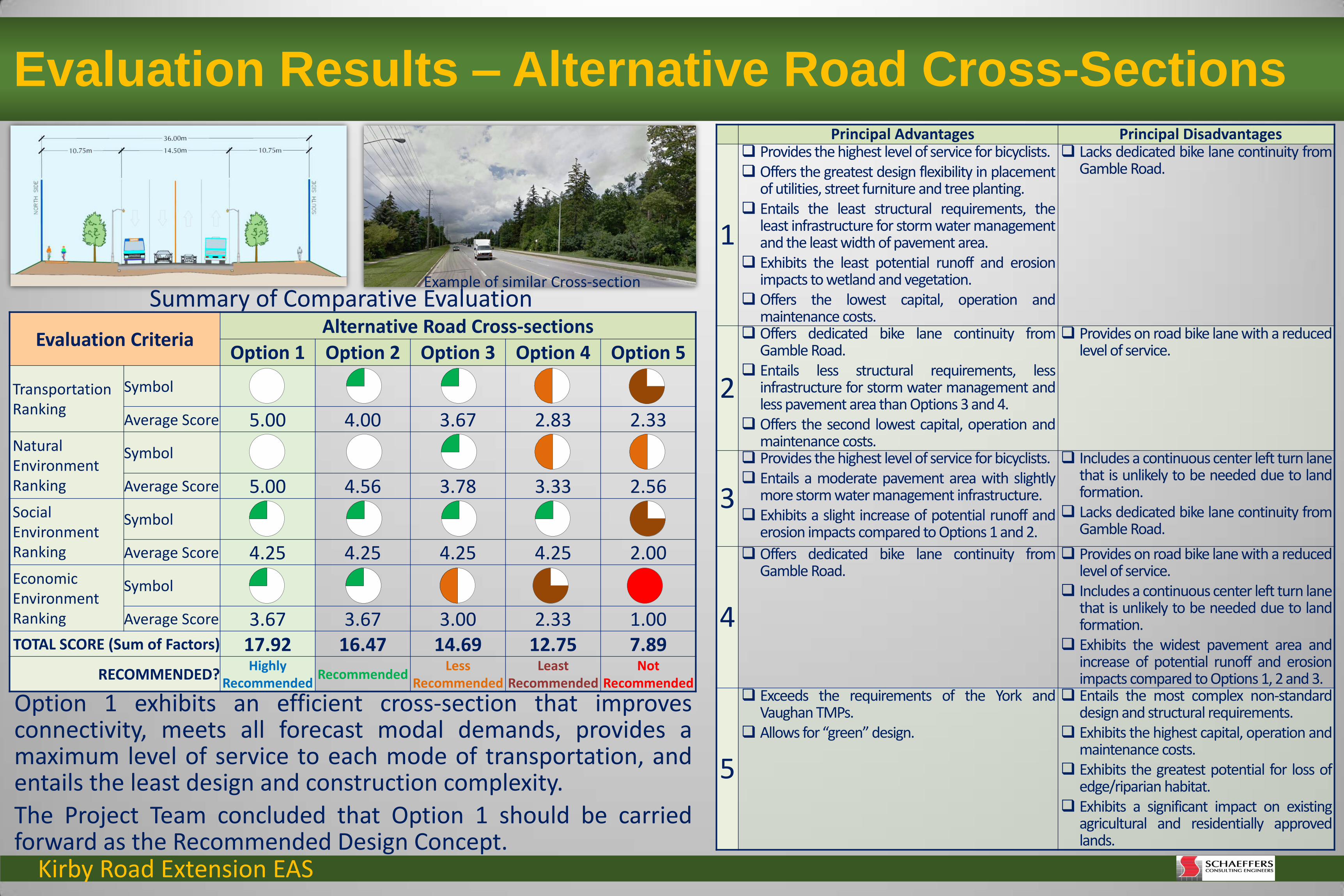
Evaluation Criteria Alternative Road Cross-sections
Option 1 Option 2 Option 3 Option 4 Option 5
Transportation Ranking
Symbol
Average Score 5.00 4.00 3.67 2.83 2.33 Natural Environment Ranking
Symbol
Average Score 5.00 4.56 3.78 3.33 2.56 Social Environment Ranking
Symbol
Average Score 4.25 4.25 4.25 4.25 2.00 Economic Environment Ranking
Symbol
Average Score 3.67 3.67 3.00 2.33 1.00 TOTAL SCORE (Sum of Factors) 17.92 16.47 14.69 12.75 7.89
RECOMMENDED? Highly
Recommended Recommended
Less Recommended
Least Recommended
Not Recommended
Evaluation Results – Alternative Road Cross-Sections
Option 1 exhibits an efficient cross-section that improves connectivity, meets all forecast modal demands, provides a maximum level of service to each mode of transportation, and entails the least design and construction complexity.
The Project Team concluded that Option 1 should be carried forward as the Recommended Design Concept.
Principal Advantages Principal Disadvantages
1
Provides the highest level of service for bicyclists. Offers the greatest design flexibility in placement
of utilities, street furniture and tree planting. Entails the least structural requirements, the
least infrastructure for storm water management and the least width of pavement area.
Exhibits the least potential runoff and erosion impacts to wetland and vegetation.
Offers the lowest capital, operation and maintenance costs.
Lacks dedicated bike lane continuity from Gamble Road.
2
Offers dedicated bike lane continuity from Gamble Road.
Entails less structural requirements, less infrastructure for storm water management and less pavement area than Options 3 and 4.
Offers the second lowest capital, operation and maintenance costs.
Provides on road bike lane with a reduced level of service.
3
Provides the highest level of service for bicyclists. Entails a moderate pavement area with slightly
more storm water management infrastructure. Exhibits a slight increase of potential runoff and
erosion impacts compared to Options 1 and 2.
Includes a continuous center left turn lane that is unlikely to be needed due to land formation.
Lacks dedicated bike lane continuity from Gamble Road.
4
Offers dedicated bike lane continuity from Gamble Road.
Provides on road bike lane with a reduced level of service.
Includes a continuous center left turn lane that is unlikely to be needed due to land formation.
Exhibits the widest pavement area and increase of potential runoff and erosion impacts compared to Options 1, 2 and 3.
5
Exceeds the requirements of the York and Vaughan TMPs.
Allows for “green” design.
Entails the most complex non-standard design and structural requirements.
Exhibits the highest capital, operation and maintenance costs.
Exhibits the greatest potential for loss of edge/riparian habitat.
Exhibits a significant impact on existing agricultural and residentially approved lands.
Example of similar Cross-section Summary of Comparative Evaluation

Kirby Road Extension EAS
Evaluation Criteria Alternative Road Alignments
Alignment 4
Alignment 5
Alignment 6
Alignment 6A
Transportation Ranking
Symbol Average Score 4.17 4.50 3.50 3.67
Natural Environment Ranking
Symbol Average Score 3.22 3.11 3.67 3.89
Social Environment Ranking
Symbol Average Score 3.38 3.63 3.13 3.00
Economic Environment Ranking
Symbol Average Score 3.67 4.00 3.00 2.67
TOTAL SCORE (Sum of Factors) 14.43 15.24 13.29 13.22
RECOMMENDED? Recommended Highly
Recommended Least
Recommended Not
Recommended
Evaluation Results – Alternative Road Alignments
The Project Team concluded that Alignment 5 represents an acceptable balance of advantages and disadvantages across the range of evaluation criteria and should be carried forward as the Recommended Design Concept.
Principal Advantages Principal Disadvantages
4
Less complex design and construction Small earthwork quantity and grading
footprint Avoids hedgerow and cultural farmscape of
interest Minimal impact on future development
Significant impact to PSW riparian area due to 50m crossing structure
Significant impact to and direct removal of woodlands which provide Significant Wildlife Habitat Moderate impact to habitat for Species at Risk
Significant impact on agricultural lands Moderate private land acquisition requirements
5
Least complex design and construction Smallest earthwork quantity and grading
footprint Least impact on agricultural lands Minimal private land acquisition
requirements Minimal impact on future development
Significant impact to PSW riparian area due to 50m crossing structure
Significant impact to and direct removal of woodlands which provide Significant Wildlife Habitat Significant impact to habitat for Species at Risk
Highest potential for archaeological findings Edge impacts to cultural farmscape of interest
6
Minimal impact to woodlands which provide Significant Wildlife Habitat
Minimal impact to East Patterson Creek Avoids hedgerow and cultural farmscape of
interest
Moderate impact to PSW and riparian area Moderate impact to habitat for Species at Risk Complex design and construction Large earthwork quantity and grading footprint. Significant impact on agricultural lands. Challenge for traffic safety due to high number of curves and
transition segments between curves, increased possibility for black ice conditions.
Significant impact on future development proposals High private land acquisition requirements
6A
Minimal impact to PSW and riparian area Minimal impact to woodlands which
provide Significant Wildlife Habitat Minimal impact to East Patterson Creek Avoids hedgerow and cultural farmscape of
interest Lowest potential for archaeological findings
Most complex design and construction Largest earthwork quantity and grading footprint. Challenge for traffic safety due to highest number of curves
and transition segments between curves, increased possibility for black ice conditions
Significant impact on agricultural lands. Very significant impact on future development proposals Highest private land acquisition requirements
Summary of Comparative Evaluation

Kirby Road Extension EAS
What are the next steps?
Any Questions ?
Please talk with one of the members of the project team to address your issues/concerns
More details about the study can also be found at:
http://www.schaeffers.com/kir
byroadextension.asp
How can you help us?
Please share your valuable input and fill the Response Form
Response Forms can be returned to the project team members or sent by email / mail by July 13, 2018 to:
Leonid Groysman, Class EA Lead, Schaeffers Consulting Engineers,
6 Ronrose Drive, Concord, ON L4K 4R3 Phone: 905-738-6100 x 245
Fax : 905-738-6875 E-mail: [email protected]
PHASE 3B
Evaluation
Collect and address comments Confirm Preferred Design
Concept(s) Having gained further input from all interested parties in reviewing the evaluation steps and arriving at the best decision, the Recommended Design Concept(s) will be confirmed as the Preferred Design Concept(s). Develop Project Description Planned Studies: Wetland/watercourse Crossing
Evaluation Floodplain Analysis Air Quality Impact Assessment Noise Impact Assessment Climate Change Impact
Assessment
PHASE 4
Environmental Study Report (ESR)
Submission to the MOECC and TRCA for review is planned for mid Fall 2018 and to the City of Vaughan for early Winter 2018.
PHASE 4
Notice of Study Completion
Placement of ESR on public record for a 30 day mandatory public review is planned for early Spring 2019.
PHASE 3B
Consultation
TAG #3 and CLC #3 meetings to present Project Description are planned for late September 2018