kirklees local plan examination matter 26 … · these submissions address the inspector’s...
TRANSCRIPT

KIRKLEES LOCAL PLAN
EXAMINATION
MATTER 26 – GENERAL
APPROACH IN PART 2 OF THE
PLAN
SITE H591: LAND TO THE WEST
OF CLIFFE MOUNT, FERRAND
LANE, GOMERSAL
January 2018
On behalf of KCS Development Ltd.

Kirklees Local Plan Examination: Hearing Statement – Matter 26
CONTENTS
1.0 Introduction 1
2.0 Matter 26 2
3.0 Conclusion 5
Appendices
Appendix 1: Dwg. No. 1332 SK 05 – site layout plan
Appendix 2: Kirklees Council pre-application response
Appendix 3: Case officer email dated 15 November 2017

Kirklees Local Plan Examination: Hearing Statement – Matter 26 Page 1
1.0 INTRODUCTION
1.01. Carter Jonas LLP welcomes the opportunity to make submissions on behalf of KCS Development Ltd. for
consideration at the Examination into the soundness and legal compliance of the Kirklees Publication Draft
Local Plan. We submitted representations on behalf of our client to the previous iteration of the plan in
December 2016.
1.02. We have reviewed the questions in relation to Matter 26 set out by the Inspector and responded where
appropriate to our case. In commenting on the Kirklees Local Plan, our representations refer directly to the
soundness of the document (that the plan has been positively prepared, is justified, effective and consistent
with national planning policy).
1.03. These submissions address the Inspector’s questions and should be read in conjunction with the
representations submitted to the publication stage in December 2016 and the Hearing Statement on behalf of
KCS Development in respect of Matter 37.
1.04. We have responded in question order as set out by the Inspector. Where we have no comments either way in
respect of a question and in the interests of expediency we have disregarded that question for the purposes of
this Hearing Statement.

Kirklees Local Plan Examination: Hearing Statement – Matter 26 Page 2
2.0 MATTER 26 – DOES PART 2 OF THE LOCAL PLAN SET OUT AN EFFECTIVE FRAMEWORK FOR THE DELIVERY OF ALLOCATIONS AND THE PROTECTION OF DESIGNATION SITES, WHICH IS ROBUST AND IN LINE WITH NATIONAL POLICY?
2.01 In respect of Matter 26 we respond to the relevant questions in turn below, with the sub-headings duplicating
each question for ease of reference.
a) Does the inclusion of site allocation wording in text boxes, rather than policies, have implications for the effectiveness and deliverability of Part 2 of the Local Plan?
2.02 Taking into account our client’s site interests in respect of site H591 - Land to the west of Cliffe Mount, Ferrand
Lane, Gomersal we consider the inclusion of site allocation wording within a text box instead of a more
traditional policy format to have no implications for the effectiveness and/or deliverability of the Local Plan.
b) Are the infrastructure and open space requirements of each site clearly set out in Part 2 of the Plan? Is it clear what developers are expected to provide and when?
2.03 It is clear from the Local Plan as drafted that Site H591 is expected to deliver circa 3.87ha of housing land at
an indicative capacity of 135 dwellings. We agree that there are no specific infrastructure or open spaces
requirements that would need to be addressed by the Local Plan.
c) Are other site constraints and related mitigation measures clearly defined in Part 2 of the Plan? Is there sufficient detail to effectively guide development and make it clear what will be permitted?
2.04 We consider that the whilst the Constraints listed for Site H591 are clearly defined, they are inaccurate, as
follows:
• No third party land is required to achieve the visibility splays;
• No improvements are required to the local highway network;
• No protected trees will be impacted by the potential access point on Cliffe Lane;
• There are no significant noise sources near the site.
Whilst we consider there to be sufficient detail within the H591 text we are of the view that these ‘constraints’
are misleading and should be omitted.
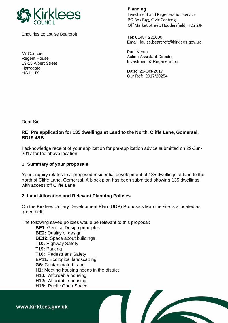
2.05 In particular, we draw attention to a formal pre-application response dated 25 October 2017. The plan upon
which this was based (Dwg. No. 1332 SK 05) is enclosed at Appendix 1 of this Hearing Statement and shows
135 dwellings with access off Cliffe Lane in the position identified by the draft allocation. The Kirklees Council
response letter is enclosed at Appendix 2. In respect of each matter in turn:
Visibility
2.06 As shown on Dwg. No. 1332 SK 05 at Appendix 1, 2.4m x 43m visibility spays are achievable within the
highway and land within the control of KCS Development. Visibility is not raised by the local highway authority
within the pre-application response letter.
Local highway network
2.07 The pre-application response also confirms there “are no in-principle objections or concerns from Highways
Development Management”. No improvements to local highway links are required

Kirklees Local Plan Examination: Hearing Statement – Matter 26 Page 3
Protected trees
2.08 The pre-application response is incorrect at section 4.4 where it mentions “protected trees near the access
point”. In an email response dated 15 November 2017 the development management case officer, Louise
Bearcroft confirms:
With respect to the protected trees, Council maps still show a legal charge, however it is noted the
protected trees in the curtilage of No.271 have been previously felled. Although records prior to
2007 are difficult to access, officers will assume the position that they were felled legally, and for
the purpose of any future planning application no longer exist.
2.09 A copy of the email is enclosed at Appendix 3.
Noise sources 2.10 We are aware of no specific and significant noise sources in the vicinity of the site that would justify the
inclusion of this alleged constraint. No clarity on this has been provided by the council as part of the pre-
application response or draft allocation evidence base.
2.11 Our representations of December 2016 incorporated a noise report by ENS Ltd. which confirms only distant
traffic noise and wildlife sounds.
Heritage assets
2.12 Whilst the north-eastern corner of Site H591 is close to the boundary with Gomersal Conservation Area and
the curtilage of a Grade II listed building we draw attention to the conclusion of our March 2016 Heritage
Impact Assessment at paragraph 7.0 which confirms
The proposed development site is physically and visually remote from the majority of the
conservation area, particularly due to the presence of the intervening ridge and modern housing,
and even where the two areas come into close proximity the impact will be negligible. The
conclusion of this analysis is therefore that development of the proposed site for housing will have
no detrimental impact on the conservation area, or on any of the listed buildings within the area.
2.13 This will be expanded upon within our Matter 37 Hearing Statement, given impact of the proposals on the
historic environment is the sole specific question raised in respect of Site H591.
d) Should Part 2 of the Plan specify when Masterplans are required in association with an allocation site? Which sites would this apply to?
2.14 No masterplan need be specified within the Local Plan in respect of Site H591.
e) Should the Plan specify where planning permission has already been granted, for reasons of effectiveness?
2.15 Given the adoption of the Local Plan will represent a ‘snapshot in time’ it is neither necessary nor appropriate
for it to indicate sites where planning permission had already been granted before adoption.
k) Has flood risk been factored into indicative site capacity estimates?

Kirklees Local Plan Examination: Hearing Statement – Matter 26 Page 4
2.16 We consider that flood risk is of no issue in respect of Site H591 and will have no effect on the ability of the
site to deliver circa 135 dwellings.
Summary
2.17 In summary, we consider that subject to the removal of the 4 Constraints listed for Site H591 and noted at
paragraph 2.04 of this statement, Part 2 of the Local Plan will clearly set out an effective framework for the
delivery of this housing allocation in a robust manner and in accordance with national policy?

Kirklees Local Plan Examination: Hearing Statement – Matter 26 Page 5
3.0 CONCLUSION
3.01. In conclusion we support the approach taken within the Local Plan apart from the concerns noted above in
respect of the suggested constraints for Site H591.
3.02. Subject to the deletion of the bullet points in respect of visibility splays, local highway links, protected trees and
noise we consider the text in respect of H591 to set out an effective basis for the delivery of the site for
housing.
3.03. We trust this Hearing Statement and as presented at the Matter 26 hearing session will be taken into account
within the Inspectors’ report.

Kirklees Local Plan Examination: Hearing Statement – Matter 26
APPENDIX 1: DWG. NO. 1332 SK 05 – SITE LAYOUT PLAN

Kirklees Local Plan Examination: Hearing Statement – Matter 26
APPENDIX 2: KIRKLEES COUNCIL PRE-APPLICATION RESPONSE
Kirklees Local Plan Examination: Hearing Statement – Matter 26
APPENDIX 3: CASE OFFICER EMAIL DATED 15 NOVEMBER 2017

Planning Investment and Regeneration Service PO Box B93, Civic Centre 3, Off Market Street, Huddersfield, HD1 2JR
Enquiries to: Louise Bearcroft Mr Courcier Regent House 13-15 Albert Street Harrogate HG1 1JX
Dear Sir RE: Pre application for 135 dwellings at Land to the North, Cliffe Lane, Gomersal, BD19 4SB I acknowledge receipt of your application for pre-application advice submitted on 29-Jun-2017 for the above location. 1. Summary of your proposals Your enquiry relates to a proposed residential development of 135 dwellings at land to the north of Cliffe Lane, Gomersal. A block plan has been submitted showing 135 dwellings with access off Cliffe Lane. 2. Land Allocation and Relevant Planning Policies On the Kirklees Unitary Development Plan (UDP) Proposals Map the site is allocated as green belt. The following saved policies would be relevant to this proposal:
BE1: General Design principles BE2: Quality of design BE12: Space about buildings T10: Highway Safety T19: Parking T16: Pedestrians Safety EP11: Ecological landscaping G6: Contaminated Land H1: Meeting housing needs in the district H10: Affordable housing H12: Affordable housing H18: Public Open Space
Tel: 01484 221000 Email: [email protected] Paul Kemp Acting Assistant Director Investment & Regeneration Date: 25-Oct-2017 Our Ref: 2017/20254

Planning Investment and Regeneration Service PO Box B93, Civic Centre 3, Off Market Street, Huddersfield, HD1 2JR EP4: Noise sensitive development
EP11: Integral landscaping scheme to protect / enhance ecology NE9: Retention of mature trees
The following chapters of the National Planning Policy Framework 2012 (NPPF) would also be relevant:
Chapter 6: Delivering a wide choice of high quality homes
Chapter 7: Requiring Good Design
Chapter 9: Protecting Green Belt land
Chapter 10: Meeting the challenge of climate change, flooding and coastal change
Chapter 11: Conserving and Enhancing the natural environment The Council is currently in the process of reviewing its development plan through the production of a Local Plan. The Council’s Local Plan was submitted to the Secretary of State for Communities and Local Government on 25th April 2017, so that it can be examined by an independent inspector. The weight to be given to the Local Plan will be determined in accordance with the guidance in paragraph 216 of the National Planning Policy Framework. In particular, where the policies, proposals and designations in the Local Plan do not vary from those within the UDP, do not attract significant unresolved objections and are consistent with the National Planning Policy Framework (2012), these may be given increased weight. Pending the adoption of the Local Plan, the UDP (saved Policies 2007) remains the statutory Development Plan for Kirklees. 3. Consultations As part of the pre application advice service we have consulted the following internal consultees who would be part of the decision making process should an application be received:-
Highways
Environmental Services
Lead Local Flood Authority
Arboricultural Officer
Ecologist
Conservation and Design
West Yorkshire Police Architectural Liaison Officer
Strategic Housing
Landscaping
Education 4. Relevant Matters for Consideration 4.1 Principle of Development The site is located within the green belt on the Kirklees Unitary Development Plan Proposals Map. Paragraph 87 of the National Planning Policy Framework stipulates that as with previous Green Belt policy, inappropriate development is, by definition, harmful to

Planning Investment and Regeneration Service PO Box B93, Civic Centre 3, Off Market Street, Huddersfield, HD1 2JR the Green Belt and should not be approved except in very special circumstances.
Paragraph 88 stipulates that Local Planning Authorities should ensure that substantial weight is given to any harm to the Green Belt. ‘Very special circumstances’ will not exist unless the potential harm to the Green Belt by reason on inappropriateness, and any other harm, is clearly outweighed by other considerations. Paragraph 89 stipulates a Local Planning Authority should regard the construction of new buildings as inappropriate in the Green Belt. The proposal does not fall under one of the exceptions in Paragraph 89 and is inappropriate development. The site forms a part of a wider draft housing allocation in the emerging local plan (H591). It is considered that the proposed Local Plan housing allocation of this green belt site cannot be afforded significant weight in the planning applications process at this stage. The green belt boundary can only be altered in exceptional circumstances, through the preparation or review of a Local Plan. The Local Plan has reached an advanced stage but there are unresolved objections to the approach to the release of land from the green belt for development. Any certainty relating to the removal of sites from the green belt would only be provided by the adoption of the Local Plan (expected in 2018). Until this point, the statutory green belt boundary remains as shown in the adopted Kirklees Unitary Development Plan and proposals for inappropriate development in the green belt will need to demonstrate very special circumstances for an application to be approved. No very special circumstances have been provided and officers are unable to support the principle of residential development on this green belt site. Without prejudice to the Council’s position on the principle of development, consultees have provided their technical comments on the proposed layout (1332 SK 05) as follows: 4.2 Highway Matters The enquiry is supported by a Transport Appraisal letter which mainly details the surrounding context of the site. The site is proposed to be served by a new access directly from Cliffe Lane with the site being served by an internal estate road forming cul-de-sacs with angular turning heads. There are no in-principle objections or concerns from Highways Development Management at this stage. Any detailed application coming forward would need to be fully supported by a comprehensive Transport Assessment and Travel Plan. The scope of any Transport Assessment would need to be agreed with Highways Development Management in advance. Any Transport Assessment would need to sufficiently demonstrate the traffic generation and distribution profile of the development and demonstrate that the internal site layout is fit for purpose. The proposed access and internal site layout would need to be designed to fully adoptable standards. The proposed site access would need to achieve the required vehicular visibility splays and be supported by a Stage 1 Road Safety Audit. Internally to the site, the Transport Assessment should be supported by swept path analysis vehicle tracking demonstrating that an 11.85m refuse vehicle can access and egress the site in a safe and efficient manner and demonstrate that the proposed turning heads are fit for purpose in this regard. The development will be required to fully meet the Council’s adopted parking standards and this will need to include visitor parking provision.

Planning Investment and Regeneration Service PO Box B93, Civic Centre 3, Off Market Street, Huddersfield, HD1 2JR 4.3 Layout and Design
The site borders the boundary of the Gomersal Conservation Area, and to the north-east of the site is the grade II listed Gomersal Methodist Church. The proposal will need to have regard to the impact on the setting of these heritage assets. It is also important that the agricultural feel of the land is maintained. The layout shown on plan Ref 1322 SK 05 is for a high density of development and closely spaced dwellings, particularly in the north-eastern corner of the site. Consideration needs to be given to providing adequate space about buildings, and a mitigative landscaping to integrate the proposed development into its surroundings. The details of the landscaped areas and areas of public open space should include any SUDs proposals as these will affect what planting can be achieved. The proposed development should incorporate crime prevention design with front gardens to have a marked boundary, and the avoidance of shared rear access footpaths. Dwellings should have boundary treatment of an adequate height, and public spaces should be well overlooked and illuminated. Car parking provision should be in curtilage or within view of the car owner’s home. 4.4 Ecology and Trees The predominant habitats on site appear to be of low ecological value, although the site may support important ecological features. The site appears to have capacity to be developed for residential use while avoiding significant ecological impacts, however appropriate surveys will be required to demonstrate that the proposals will avoid significant ecological impacts and that the mitigation hierarchy has been applied. The recommendations identified in the Preliminary Ecological Assessment undertaken to support its proposed allocation in the Local Plan should be incorporated into the design proposals. An issue that needs investigation is the potential of the proposals to impact on the green infrastructure resource. Part of the site is identified as part of the Kirklees Wildlife Habitat Network. Due to the scale of the proposals and the presence of identified green infrastructure resource, any application should be supported by an Ecological Impact Assessment produced in accordance with CIEEM guidance. Any future application should also be accompanied with a BS5837 Tree Survey. The tree constraints as identified by the survey should be used to adapt the layout to allow for the retention of trees within the proposals as per UDP policies NE 9, mature trees to be retained; or BE2, existing trees to form an integral part of the design. The layout submitted does present a few issues with the existing trees such as proximity of roads or houses to trees and shade issues were houses are close to trees on the southern and western boundary. These issues should be addressed in any future proposals and/or detailed within the Tree Survey. There are protected trees near the access point to the site and at the north eastern corner of the site. 4.5 Flood Risk and Drainage
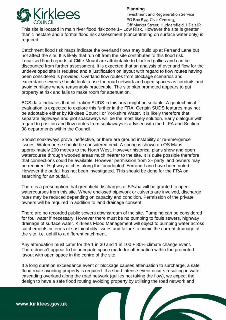
Planning Investment and Regeneration Service PO Box B93, Civic Centre 3, Off Market Street, Huddersfield, HD1 2JR This site is located in main river flood risk zone 1– Low Risk. However the site is greater
than 1 hectare and a formal flood risk assessment (concentrating on surface water only) is required. Catchment flood risk maps indicate the overland flows may build up at Ferrand Lane but not affect the site. It is likely that run off from the site contributes to this flood risk. Localised flood reports at Cliffe Mount are attributable to blocked gullies and can be discounted from further assessment. It is expected that an analysis of overland flow for the undeveloped site is required and a justification on layout with regard to flow routes having been considered is provided. Overland flow routes from blockage scenarios and exceedance events should look to use the road network and open spaces as conduits and avoid curtilage where reasonably practicable. The site plan promoted appears to put property at risk and fails to make room for attenuation. BGS data indicates that infiltration SUDS in this area might be suitable. A geotechnical evaluation is expected to explore this further in the FRA. Certain SUDS features may not be adoptable either by Kirklees Council or Yorkshire Water. It is likely therefore that separate highways and plot soakaways will be the most likely solution. Early dialogue with regard to position and flow routes from soakaways is advised with the LLFA and Section 38 departments within the Council. Should soakaways prove ineffective, or there are ground instability or re-emergence issues. Watercourse should be considered next. A spring is shown on OS Maps approximately 200 metres to the North West. However historical plans show and open watercourse through wooded areas much nearer to the site. It is quite possible therefore that connections could be available. However permission from 3rd party land owners may be required. Highway ditches along the ‘unadopted’ Ferrand Lane have been noted. However the outfall has not been investigated. This should be done for the FRA on searching for an outfall. There is a presumption that greenfield discharges of 5l/s/ha will be granted to open watercourses from this site. Where enclosed pipework or culverts are involved, discharge rates may be reduced depending on capacity and condition. Permission of the private owners will be required in addition to land drainage consent. There are no recorded public sewers downstream of the site. Pumping can be considered for foul water if necessary. However there must be no pumping to fouls sewers, highway drainage of surface water. Kirklees Flood Management will object to pumping water across catchements in terms of sustainability issues and failure to mimic the current drainage of the site, i.e. uphill to a different catchment. Any attenuation must cater for the 1 in 30 and 1 in 100 + 30% climate change event. There doesn’t appear to be adequate space made for attenuation within the promoted layout with open space in the centre of the site. If a long duration exceedance event or blockage causes attenuation to surcharge, a safe flood route avoiding property is required. If a short intense event occurs resulting in water cascading overland along the road network (gullies not taking the flow), we expect the design to have a safe flood routing avoiding property by utilising the road network and

Planning Investment and Regeneration Service PO Box B93, Civic Centre 3, Off Market Street, Huddersfield, HD1 2JR open space. Where this is not reasonably practicable (small cul de sacs away from the
main flow route), mitigation will be accepted. The LPA is obliged to ensure the maintenance and management of sustainable drainage for the lifetime of the development. A management company is envisaged along with a suitable plan to cover this requirement until such a time that the drainage features are adopted by a responsible body. A temporary plan to deal with additional run off post site soil and vegetation strip will be required to avoid downstream flooding and sedimentation of watercourses and local drainage networks. It is strongly recommended that drainage matters are considered prior to the consideration of a possible layout to avoid putting property at risk. 4.6 Contributions The application attracts contributions for affordable housing, education and public open space. Affordable Housing – The Kirklees Interim affordable housing policy requires 20% of dwellings on sites with over 11 or more dwellings for affordable housing. On-site provision is preferred. In this case 27 dwellings can be allocated for affordable housing, to include 15 affordable rent dwellings and 12 intermediate dwellings. In this area there is demand for affordable homes from 1-2 bed to 3 bed+. Public Open Space – On-site public open space is required at a rate of 30 sqm per dwelling. Education – An education contribution of £572,99 is required. 4.7 Environmental Matters The development has been assessed in accordance with the West Yorkshire Low Emission Strategy Planning Guidance and is regarded as a major development. You will be required to provide a Full Air Quality Impact Assessment including calculating the monetary damages from the development. The monetary value of the damages should be reflected in money spent on low emission mitigation measures. You will also be required to produce a Travel Plan including mechanisms for discouraging high emission vehicle use and encouraging modal shift (i.e. public transport, cycling and walking) as well as the uptake of low emission fuels and technologies. In addition you will need to install 1 charging point per dwelling with dedicated parking, or 1 charging point per 10 unallocated
parking spaces. Whilst this site is not recorded as potentially contaminated, the proposed size is such that as minimum of a Phase I (Desk Top Study) contaminated land report is required. Depending on the outcome of the report, further site investigation/remediation may be required.

Planning Investment and Regeneration Service PO Box B93, Civic Centre 3, Off Market Street, Huddersfield, HD1 2JR A noise report should accompany any planning submission to address all noise sources
likely to affect the site including commercial activities nearby and road traffic noise. Noise mitigation measures may be required based on the report’s conclusions. 4.8 Ward Member Comments Councillor Lisa Holmes and Councillor David Hall attended the pre-application meeting and provided their comments. 4.9 Conclusion
In summary, officers are unable to support the principle of residential development on this green belt site. Although the site forms a part of a wider draft housing allocation in the emerging local plan (H591), until the adoption of the Local Plan (expected in 2018), the statutory green belt boundary remains as shown in the adopted Kirklees Unitary Development Plan and proposals for inappropriate development in the green belt will need to demonstrate very special circumstances for an application to be approved. 5. Validation Requirements Should you wish to pursue an application, the information you need to provide with your application is detailed in the Validation checklist which can be viewed under the heading ‘Guidance and advice notes’ on the Kirklees Planning and Development website: http://www.kirklees.gov.uk/beta/planning-and-development.aspx 6. Planning Application Fee You can use the following link to calculate how much the planning fee would be for your proposal:- https://1app.planningportal.co.uk/FeeCalculator/Standalone?region=1 I hope you find this information helpful Yours faithfully Disclaimer Any views or opinions expressed are in good faith, and without prejudice to the formal consideration of any planning application, which will be subject to public consultation (which will include the relevant Town or Parish Council) and ultimately be decided by the Council. It should be noted that subsequent alterations to legislation or local, regional and national policies might affect the advice given. You should be aware of the Council’s Local Development Scheme which sets out the programme for developing its Local Plan. You are advice to seek further advice once any consultation drafts are published. Caution should be exercised in respect of pre-application advice which is not submitted within a short time of the Council’s advice letter.

Planning Investment and Regeneration Service PO Box B93, Civic Centre 3, Off Market Street, Huddersfield, HD1 2JR
Yours Faithfully
David Wordsworth Major Applications Team Leader

1
Grundy, Simon
From: Louise Bearcroft <[email protected]>
Sent: 15 November 2017 12:29
To: Courcier, Stephen
Subject: RE: 2017/20254 - Land to the North, Cliffe Lane, Gomersal [CJ-WORKSITE.FID42543]
Stephen,
The list of technical consultees are as follows:
• Paul Farndale – Lead Local Flood Authority
• Nigel Hunston – Conservation and Design Group Leader
• Steven Sampson – Group Engineer
• Emma Mills – Landscape Architect Manager
In respect of the minutes of the meeting which were circulated, I have received the following additional comments:
Landscape Architect:
With regards POS and landscape issues, we rarely receive sufficient landscape information until detailed design
stage for reserved matters. However, given the sloping nature of the site and issues raised about drainage, the
location of any proposed suds might need to be under some proposed pos or landscaped areas. Given that
attenuation tanks generally are located over 5m from any tree planting and can include a number of IC covers
(making them potentially inaccessible to the public as open space), it would be good for the landscape design
drawings to include any SuDS proposals on them -including cross sections. It would be good if they could provide
any landscape info earlier in the process, if possible, so we can provide more comprehensive landscape comments
generally.
Lead Local Flood Authority:
Drainage at detailed design stage is too late. Drainage needs to be considered as part of the layout design with
joined up thinking to avoid putting property at risk. Road adoption will also be at risk as no space has been made
outside the highway.
With respect to the protected trees, Council maps still show a legal charge, however it is noted the protected trees
in the curtilage of No.271 have been previously felled. Although records prior to 2007 are difficult to access, officers
will assume the position that they were felled legally, and for the purpose of any future planning application no
longer exist.
With respect to affordable housing, across the district Kirklees has worked on a spilt of 54% Rent to 46%
intermediate, and Strategic Housing provided their comments accordingly. Starter Homes will of course be
considered and Strategic Housing welcome early discussions on this matter.
Kind Regards Louise Bearcroft Planning Officer MRTPI Development Management Investment & Regeneration Service Kirklees Council Tel: 01484 221000
2
E-mail: [email protected] Web: www.kirklees.gov.uk/planning
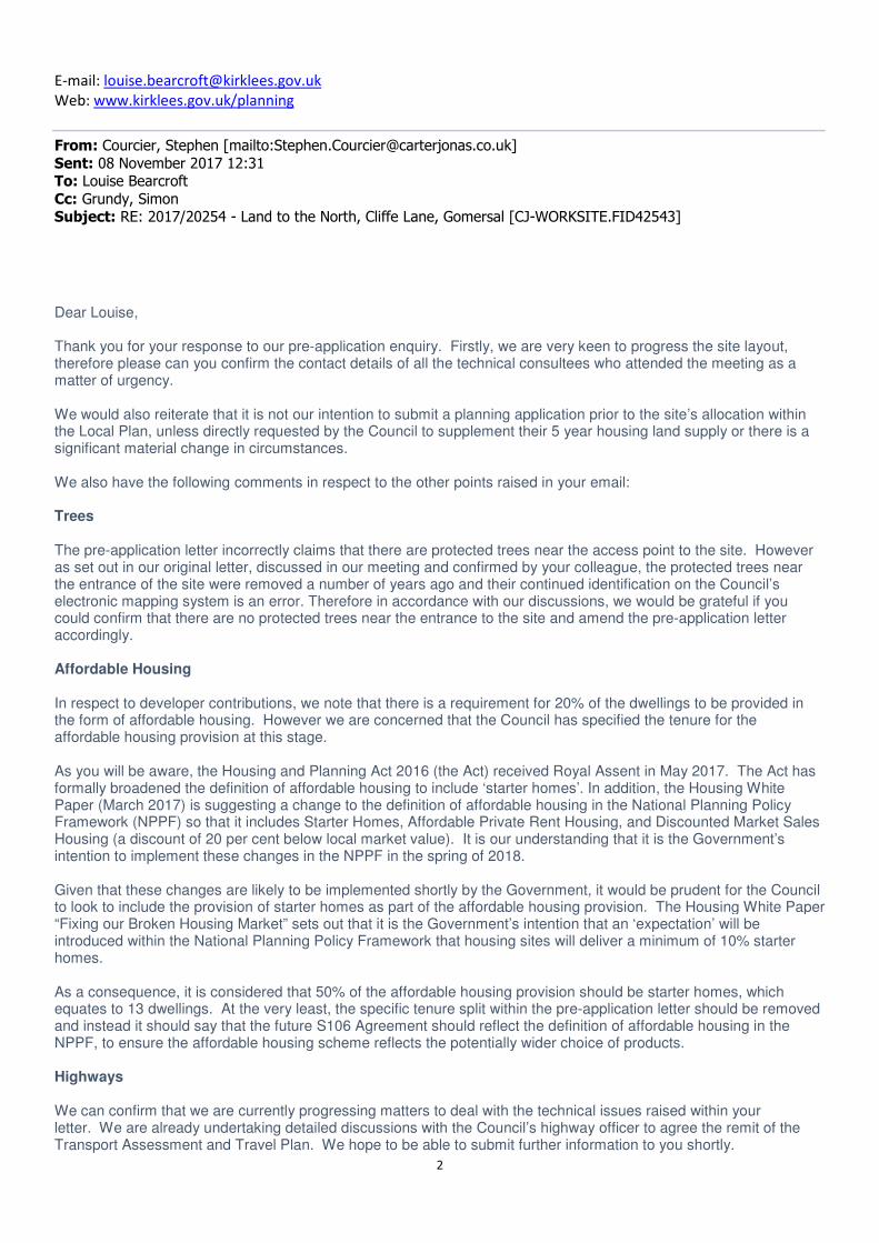
From: Courcier, Stephen [mailto:[email protected]]
Sent: 08 November 2017 12:31 To: Louise Bearcroft
Cc: Grundy, Simon Subject: RE: 2017/20254 - Land to the North, Cliffe Lane, Gomersal [CJ-WORKSITE.FID42543]
Dear Louise, Thank you for your response to our pre-application enquiry. Firstly, we are very keen to progress the site layout, therefore please can you confirm the contact details of all the technical consultees who attended the meeting as a matter of urgency. We would also reiterate that it is not our intention to submit a planning application prior to the site’s allocation within the Local Plan, unless directly requested by the Council to supplement their 5 year housing land supply or there is a significant material change in circumstances. We also have the following comments in respect to the other points raised in your email: Trees The pre-application letter incorrectly claims that there are protected trees near the access point to the site. However as set out in our original letter, discussed in our meeting and confirmed by your colleague, the protected trees near the entrance of the site were removed a number of years ago and their continued identification on the Council’s electronic mapping system is an error. Therefore in accordance with our discussions, we would be grateful if you could confirm that there are no protected trees near the entrance to the site and amend the pre-application letter accordingly. Affordable Housing In respect to developer contributions, we note that there is a requirement for 20% of the dwellings to be provided in the form of affordable housing. However we are concerned that the Council has specified the tenure for the affordable housing provision at this stage. As you will be aware, the Housing and Planning Act 2016 (the Act) received Royal Assent in May 2017. The Act has formally broadened the definition of affordable housing to include ‘starter homes’. In addition, the Housing White Paper (March 2017) is suggesting a change to the definition of affordable housing in the National Planning Policy Framework (NPPF) so that it includes Starter Homes, Affordable Private Rent Housing, and Discounted Market Sales Housing (a discount of 20 per cent below local market value). It is our understanding that it is the Government’s intention to implement these changes in the NPPF in the spring of 2018. Given that these changes are likely to be implemented shortly by the Government, it would be prudent for the Council to look to include the provision of starter homes as part of the affordable housing provision. The Housing White Paper “Fixing our Broken Housing Market” sets out that it is the Government’s intention that an ‘expectation’ will be introduced within the National Planning Policy Framework that housing sites will deliver a minimum of 10% starter homes. As a consequence, it is considered that 50% of the affordable housing provision should be starter homes, which equates to 13 dwellings. At the very least, the specific tenure split within the pre-application letter should be removed and instead it should say that the future S106 Agreement should reflect the definition of affordable housing in the NPPF, to ensure the affordable housing scheme reflects the potentially wider choice of products. Highways We can confirm that we are currently progressing matters to deal with the technical issues raised within your letter. We are already undertaking detailed discussions with the Council’s highway officer to agree the remit of the Transport Assessment and Travel Plan. We hope to be able to submit further information to you shortly.

3
Drainage We can confirm that it is our intention to produce a detailed Flood Risk and Drainage Assessment to accompany the planning application. In addition, we are currently undertaking discussions directly with the Council’s drainage officer to design an appropriate bespoke drainage solution for the site. We can confirm that we are looking at how overland flows and SUDS can be included within the scheme. Our initial findings suggest that they can be accommodated, but it is likely to necessitate some adjustments to the layout. Ecology In respect to ecology, in line with your comments, we anticipate submitting a specific ecological impact assessment as part of the planning application. The impact assessment will build upon the findings of the Preliminary Ecological Appraisal (Phase 1 Report). We look forward to your response to the above matters. In the meantime, if you have any questions or need clarification on any of the above matters please do not hesitate to contact me. Kind regards, Stephen
Stephen Courcier MRTPI Associate For and on behalf of Carter Jonas LLP T: 0113 203 1089 M: 07970 107305 W: carterjonas.co.uk
Carter Jonas LLP First Floor 9 Bond Court Leeds LS1 2JZ
Please consider the environment - do you really need to print this email?
4
From: Louise Bearcroft [mailto:[email protected]]
Sent: 27 October 2017 09:29
To: Courcier, Stephen <[email protected]>
Subject: 2017/20254 - Land to the North, Cliffe Lane, Gomersal
Stephen
Please find attached the pre-application response for 2017/20254.
Kind Regards
Louise Bearcroft
Planning Officer MRTPI
Development Management
Investment & Regeneration Service
Kirklees Council
Tel: 01484 221000
E-mail: [email protected]
Web: www.kirklees.gov.uk/planning
Website | News | Email Updates | Facebook | Twitter This email and any attachments are confidential. If you have received this email in error – please notify the sender immediately, delete it from your system, and do not use, copy or disclose the information in any way. Kirklees Council monitors all emails sent or received.
This e-mail does not constitute any part of an offer or contract, is confidential and intended solely for the use of the individual(s) to whom it is addressed. If you are not the intended recipient be advised that you have received this email in error and that any use, dissemination, forwarding, printing, or copying of this email is strictly prohibited. Although the firm operates anti-virus programmes, it does not accept responsibility for any damage whatsoever that is caused by viruses being passed. Carter Jonas LLP is a Limited Liability corporate body which has "Members" and not "Partners". Any representative of Carter Jonas LLP described as "Partner" is a Member or an employee of Carter Jonas LLP and is not a "Partner" in a Partnership. The term Partner has been adopted, with effect from 01 May 2005, because it is an accepted way of referring to senior professionals. Carter Jonas LLP Place of Registration: England and Wales Registration Number: OC304417 Address of Registered Office: One Chapel Place, London, W1G 0BG.