know your traffic - assets.publishing.service.gov.uk · know your traffic signs official edition...
TRANSCRIPT

Know Your
TRAFFICSIGNSOfficial Edition
Know Your TRAFFIC SIGNS
How well do you know your traffic signs?Traffic signs play a vital role in directing, informing and controlling road users’ behaviour in an effort to make the roads as safe as possible for everyone. A knowledge of traffic signs is therefore essential, not just for new drivers or riders needing to pass their theory test, but for all road users, including experienced professional drivers.
This book is a fully updated edition of the highly successful Know Your Traffic Signs first published by HMSO in 1975. It contains information about the most important traffic signs, including many introduced since the 1995 edition. The aim is to illustrate and explain the vast majority of traffic signs the road user is likely to encounter.
9 780115 528552
ISBN 978-0-11-552855-2
All road users
Know Your Traffic Signs - for life, not just for learners
www.tso.co.uk
£4.99
DfT
9780115528552 010 KYTS COVER v2_0.indd 1-3 24/08/2015 12:15

Know Your
TRAFFICSIGNSOfficial Edition
London: TSO
9780115528552 011 KYTS TEXT v2_0.indd 1 21/08/2015 15:38

2
Department for Transport Great Minster House 33 Horseferry Road London SW1P 4DR Telephone 0300 330 3000 Website www.gov.uk/dft www.gov.uk/traffic-signs
Printed in Great Britain on paper containing at least 75% recycled fibre.
© Crown copyright 2007, except where otherwise stated
Copyright in the typographical arrangement rests with the Crown.
You may re-use this information (not including logos or third-party material) free of charge in any format or medium, under the terms of the Open Government Licence v2.0. To view this licence, visit www.nationalarchives.gov.uk/doc/open-government-licence/version/3 or write to the Information Policy Team, The National Archives, Kew, London TW9 4DU, or e-mail: [email protected]
Artwork of traffic signs should be reproduced accurately and not in a misleading context, for example not on roadside billboards.
ISBN 978 0 11 552855 2
First published 1975
Fifth edition 2007
Seventeenth impression 2015
Available from www.tsoshop.co.uk
9780115528552 011 KYTS TEXT v2_0.indd 2 21/08/2015 15:38

�
Contents Page
Introduction 4
The signing system 9
Warning signs 10
Regulatory signs 16
Speed limit signs 20
Low bridge signs 22
Level crossing signs and signals 26
Tram signs, signals and road markings 30
Bus and cycle signs and road markings 32
Pedestrian zone signs 37
On-street parking control signs and road markings 39
Road markings 62
Traffic calming 72
Motorway signs, signals and road markings 77
Direction signs on all-purpose roads 94
Direction signs for cyclists and pedestrians 112
Information signs 114
Traffic signals 119
Tidal flow lane control signs and signals 121
Pedestrian, cycle and equestrian crossings 122
Signs for road works and temporary situations 128
Miscellaneous signs 140

�
IntroductionWhy know your traffic signs?Traffic signs play a vital role in directing, informing and controllingroad users' behaviour in an effort to make the roads as safe aspossible for everyone. This makes a knowledge of traffic signsessential. Not just for new drivers or riders needing to pass theirtheory test, but for all road users, including experiencedprofessional drivers.
Keeping up to dateWe live in times of change. Society, technology and the economy allplay their part in changing the way we travel. New road signsconveying new messages and in new formats are introduced fromtime to time, so drivers or riders who passed their driving test a fewyears ago need to keep up to date or run the risk of failing tounderstand or comply with recently introduced signs.
A few examples of events that called for new signs include:
• Britain's first motorway
• Pelican crossings
• Reintroduction of trams
• Advanced stop lines
• Vehicle-activated signs
• Active Traffic Management.
Do youunderstand
the colourcoding onsigns such
as this?
KYTS Rough V4 Repro Oversize 27/6/07 11:51 am Page 1

�
introduction
Having experience is all very well, but it's not enough if yourknowledge is out of date.
Responsibility for traffic signsResponsibility for the road network in the UK is split among:
• the Highways Agency in England
• the Welsh Assembly Government in Wales
• the Scottish Executive in Scotland
• and local or regional highway authorities.
The central administrations above are responsible for the UK’sstrategic road network. Strategic roads are the highways that linkcities, areas of population, ports and airports. Most motorways andsome “A” roads are strategic roads.
Local or regional highway authorities are responsible for localroads, and this includes a few motorways, all other “A” roads andall other public roads. While responsibility for placing, erecting andmaintaining traffic signs is split among these bodies, it is importantthat signs are consistent both in appearance and in the way theyare used.
To ensure that the UK has a uniform traffic signing system, signsmust conform to the designs prescribed in the Traffic SignsRegulations and General Directions (although some signs mayhave been specially authorised by the Secretary of State).
The Traffic Signs Manual, published by TSO, provides detailedguidance for those responsible for designing and installing traffic signs.
For more information about traffic signs guidance, seewww.dft.gov.uk/pgr/roads/tss
KYTS Rough V4 Repro Oversize 27/6/07 11:51 am Page 2

�
A brief history of traffic signs
It was probably the Romans who first used "traffic signs" in Britain.They marked off road distances at one thousand paces (about onemile) with stones called "milliaries".
Most early signposts were erected by private individuals at their ownexpense. A law passed in 1648required each parish to place guideposts at its crossroads, but it was not until after the General Turnpike Act 1773 that these "guide posts" or"fingerposts" became more common.
During the second half of thenineteenth century, bicycles becamemore popular. Steep hills and sharpbends were very dangerous for earlycyclists, and "danger" and "caution"signs were erected at the top ofsteep hills. Signs showing skull andcrossbones were erected at the
most dangerous places. Local authorities and cycling organisationsinstalled an estimated 4000 warning signs.
The year 1896 heralded the era of themotor car, and some motoringassociations took up the business ofplacing signs. The Motor Car Act 1903made local authorities responsible forplacing certain warning and prohibitorysigns. The signs were for crossroads,
steep hills and dangerous bends. "A" and "B" numbering of roadswas introduced in 1921, and these numbers were shown onfingerpost-style signs alongside the destination and distance. Townor village name signs and warning signs for schools, level crossingsand double bends were introduced at the same time.
KYTS Rough V4 Repro Oversize 27/6/07 11:51 am Page 3

�
The main task of signposting our roads during the 1920s and1930s still fell on the motoring organisations, but in in 1931 acommittee chaired by Sir Henry Maybury was asked torecommend improvements to the signing then in use, and by 1933further new signs began to appear, including "No entry" and "Keepleft" signs, warning signs for narrow roads and bridges, lowbridges, roundabouts and hospitals. Other signs followed duringthe 1930s, including "Halt at major road ahead". These formed thebasis of our traffic signing until the early 1960s.
It was not until after 1918 thatwhite lines began to appear onBritish roads, and during the1920s their use spread rapidly.In 1926 the first Ministry ofTransport circular on the subjectlaid down general principles onthe use of white lines. In the1930s, white lines were used as"stop" lines at road junctions controlled by either police or trafficlights. Reflecting road studs (often referred to as "cat's eyes") firstcame into use in 1934. By 1944, white lines were also being usedto indicate traffic lanes and define the boundary of the maincarriageway at entrances to side roads and lay-bys, and inconjunction with "halt" signs. In 1959, regulations came into effectto control overtaking by the use of double white lines.
KYTS Rough V4 Repro Oversize 27/6/07 11:51 am Page 4
introduction

�
It was realised that the old system ofsigning would not be adequate formotorways, and the AndersonCommittee was set up in 1958 toconsider new designs. It recommendedmuch larger signs, with bluebackgrounds. Then, in 1961, theWorboys Committee began to reviewthe complete system of traffic signing. Itconcluded that the UK should adoptthe main principles of the European
system, with the message expressed as a symbol within a redtriangle (for warning signs) or a red circle (for prohibitions). Workbegan on the conversion of British signs in 1965, and this is still thebasic system in use today.
Later developmentsinclude the use of yellowbox markings at busyroad junctions, specialsigns and road markingsat pedestrian crossings,mini roundabouts andbus lanes. Regulationspublished in 1994included new regulatory and warning signs and simplified the yellowline system of waiting restrictions that was originally introduced inthe 1950s. Further Regulations were published in 2002.
More use is being made ofnew technology to providebetter information to driverson hazards, delays anddiversions. The future willundoubtedly see moredevelopments in trafficsigning to keep pace with thechanging traffic demands onour roads.
KYTS Rough V4 Repro Oversize 27/6/07 11:51 am Page 5

�
the signing system
Circlesgive orders
Triangleswarn
Rectanglesinform
Blue circles generally give a mandatory instruction,such as "turn left", or indicate a route available only to particular classes of traffic, e.g. buses and cycles only
Red rings or circles tell you what you must not do, e.g. you must not exceed 30 mph, no vehicles over the height shown may proceed
Blue rectangles are used for information signs except on motorways where blue is used for direction signs
Green rectangles are used for direction signs on primary routes
White rectangles are used for direction signs on non-primary routes, or for plates used in combination with warning and regulatory signs
There are a few exceptions to the shape and colour rules, to give certain signs greater prominence. Examples are the "STOP" and "GIVE WAY" signs
The signing systemThere are three basic types of traffic sign: signs that give orders,signs that warn and signs that give information. Each type has adifferent shape. A further guide to the function of a sign is itscolour. All triangular signs are red.
The words "must" or "must not", when used in the descriptionsthat follow, refer to legal requirements that have to be obeyed.

10
Distance to STOP line
Distance to GIVE WAY line
Traffic signals ahead
Traffic signals that operate only at certain times
Crossroads T-junction Side road Staggered junction
The priority through the junction is indicated by the broader line
Traffic merges from the left
RoundaboutTraffic merges onto main carriageway
Bend to right (left if symbol reversed)
Double bend first to the left (right if symbol reversed)
Junction on a bend(symbols may be reversed)
Plate used with "roundabout" or "bend" signs
Warning signs(other than those for low bridges, railway and tramway levelcrossings, bus and pedal cycle facilities, traffic calming androad works)

11
Plate used with warning signs where a reduction in speed is necessary
Road narrows on right (left if symbol reversed)
Risk of lorries overturning on bend to the left (right if symbol reversed)
Sharp deviation of route to the left (right if chevrons reversed) (alternative designs)
Block paving incorporated into a roundabout to indicate sharp deviation of route
Road narrows on both sides
Plates used with "road narrows" signs
Single file traffic in each direction
Road wide enough for only one line of vehicles
End of dual carriageway
Two-way traffic Two-way traffic on route crossing ahead
Near-side edge of carriageway or obstruction near that edge (alternative shapes). White markers are used on the off-side edge and amber ones on the off-side edge of a dual carriageway
warning signs

1�
Worded warning. "Ford" may be varied to "Flood", "Gate", "Gates" or "No smoking"
Try brakes after crossing a ford or before descending a steep hill
Steep hill downwards (10% is equivalent to 1:10)
Steep hill upwards (20% is equivalent to 1:5)
Plates used with "steep hill" signs
Sign used with "steep hill" or "try your brakes" signs Opening or
swing bridgeQuayside or river bank
Water course alongside road
Soft verges for distance shown
End of bridge parapet, abutment wall, tunnel mouth etc.
Tunnel Hump bridge Uneven road Slippery road
Side winds
Distance to hazard
Distance and direction to hazard
Distance over which hazard extends

1�
Low-flying aircraft or sudden aircraft noise
Slow-moving military vehicles likely to be in or crossing the road
Gliders likely
Low-flying helicopters or sudden helicopter noise
Risk of falling or fallen rocks
Slow-moving vehicles for distance shown
Traffic queues likely ahead
Risk of ice. "Ice" may be varied to "Snowdrifts"
Warning of signals (see page 120). "FIRE" maybe varied to "AMBULANCE"
Other danger. The plate indicates the nature of the hazard
Disabled pedestrians. "Disabled" may be varied to "Blind"
Frail pedestrians likely to cross
Pedestrians in road for distance shown
Zebra crossing
warning signs

1�
Children going to or from school
Alternative plates used with "school" sign
Lights warning of children likely to be crossing the road on their way to or from school (used with "school" sign)
Accompanied horses or ponies likely to be in or crossing the road
Horse-drawn vehicles likely to be in the road
Pedestrians likely to be crossing a high-speed road where there is no formal crossing point
Wild horses or ponies
Wild animals Wild fowl Migratory toad crossing
Sheep
Agricultural vehicles
Area infected by animal disease

1�
Cattle
Supervised cattle crossing
Cattle grid with indication of bypass for horse-drawn vehicles and animals
Supervised cattle crossing ahead
warning signs

1�
Regulatory signs(other than those for low bridges, railway and tramway levelcrossings, bus and pedal cycle facilities and road works)
Most regulatory signs are circular. A RED RING or RED CIRCLEindicates a prohibition. A BLUE CIRCLE generally gives a positive(mandatory) instruction or indicates a route for use only byparticular classes of vehicle (see sections on tram signs and busand cycle signs).
Two notable exceptions are:
The "STOP" sign androad markings: you muststop before crossing thetransverse line on theroad and ensure the wayis clear before enteringthe major road.
The "GIVE WAY" sign androad markings: you mustgive way to traffic on themajor road (the uprightsign or both the sign andthe triangle on the roadmight not be used atjunctions where there isrelatively little traffic).

1�
No motor vehicles
No motor vehicles except solo motorcycles
No towed caravans
No solo motorcycles
No pedestrians
No ridden or accompanied horses
No articulated vehicles
No horse-drawn vehicles
No goods vehicles over maximum gross weight shown in tonnes
End of goods vehicles restriction No vehicles
carrying explosives
No vehicles or combinations of vehicles over maximum length shown
No entry for vehicular traffic, including pedal cycles (usually indicates theend of aone-way road where all trafficis travelling in the other direction)
No vehicles except pedal cycles being pushed by hand
Alternative plates used with the "no vehicles" sign, indicating times when vehicles are prohibited, except for access
regulatory signs

1�
No vehicles over the maximum gross weight shown in tonnes. The bottom plate is used where empty vehicles are exempt
No vehicles over maximum width shown (width shown in metric and imperial units)
No vehicles over maximum width shown (width shown in imperial units)
Except for access to premises or land adjacent to the road, where there is no other route. Other exemptions may be shown
Except for loading and unloading by goods vehicles
Plates used to indicate exemptions from prohibition signs
Where changes of direction are prohibited, a red bar across the sign is used in addition to the red circle
Noright turn
Noleft turn
Exemptionplate
NoU-turn
No overtaking
Where a road or bridge is very narrow, priority must be given to traffic from the other direction (there will usually be a "give way" line indicating where to wait)
1�
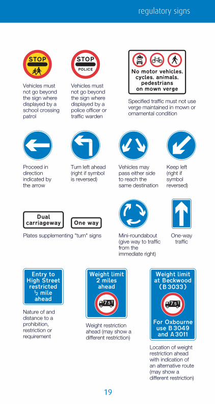
Specified traffic must not use verge maintained in mown or ornamental condition
Vehicles must not go beyond the sign where displayed by a police officer or traffic warden
Vehicles must not go beyond the sign where displayed by a school crossing patrol
Nature of and distance to a prohibition, restriction or requirement
Location of weight restriction ahead with indication of an alternative route (may show a different restriction)
Weight restriction ahead (may show a different restriction)
Proceed in direction indicated by the arrow
Turn left ahead (right if symbol is reversed)
Keep left (right if symbol reversed)
Vehicles may pass either side to reach the same destination
Mini-roundabout (give way to traffic from the immediate right)
One-way traffic
Plates supplementing "turn" signs
regulatory signs
�0
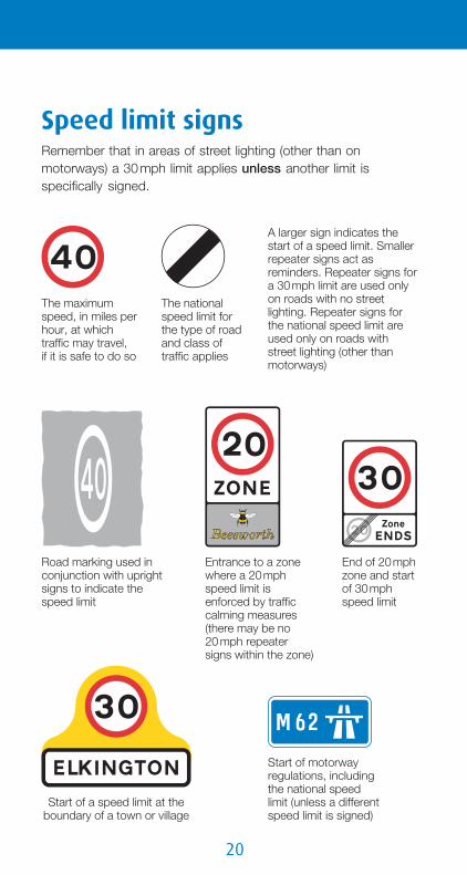
The maximum speed, in miles per hour, at which traffic may travel,if it is safe to do so
The national speed limit for the type of road and class of traffic applies
A larger sign indicates the start of a speed limit. Smaller repeater signs act as reminders. Repeater signs for a 30 mph limit are used only on roads with no street lighting. Repeater signs for the national speed limit are used only on roads with street lighting (other than motorways)
Start of a speed limit at the boundary of a town or village
Entrance to a zone where a 20 mph speed limit is enforced by traffic calming measures (there may be no20 mph repeatersigns within the zone)
End of 20 mph zone and start of 30 mph speed limit
Road marking used in conjunction with upright signs to indicate the speed limit
Start of motorway regulations, including the national speed limit (unless a different speed limit is signed)
Speed limit signsRemember that in areas of street lighting (other than onmotorways) a 30 mph limit applies unless another limit isspecifically signed.

21
speed limit signs
Point on a road with street lighting where an existing 30 mph limit originally ended but has subsequently been extended (temporary sign). This sign alerts drivers that a previous higher limit has been replaced by a 30 mph limit by the removal of speed limit signs
End of road works and any temporary speed limit through those works (may be supplemented by a sign indicating the permanent speed limit beyond the road works)
Area where speed cameras are in use
Length of road where two cameras are used to measure the average speed of a vehicle between two points
Reminder that enforcement cameras are in use (may be supplemented by a speed limit sign) Speed camera
nearby on a lit road with a 30 mph speed limit (i.e. where there are no speed limit repeater signs)
Speed camera nearby on an unlit road subject to the national speed limit (i.e. where there are no speed limit repeater signs)
End of minimum speed requirement
Maximum speed advised, in miles per hour, at a bend (the plate may be used with other warning signs)
Minimum speed permitted, in miles per hour, unless it is impracticable or unsafe to comply
9780115528552 011 KYTS TEXT v2_1.indd 21 14/04/2016 16:35

��
Low bridge signs
Bridges particularly at risk from strikesmay have a variable message sign thatis activated by high vehicles passingthrough an infra-red beam. When thesign is activated, four amber lampsflash, the top pair alternating with thebottom pair.
Each year there arehundreds of incidents inwhich bridges are struck byvehicles too high to passunder them. Both rail androad users have been killedin these incidents. Look outfor signs in this section andmake sure that you arenot a bridge basher.
All bridges with a clearance of less than 16 feet 6 inches (about5 metres) are normally signed. Both regulatory roundels andwarning triangles can be used, depending on the type of bridge.
Regulatory signs
No vehiclesover the height shown may pass the sign (height shownin metric and imperial units)
No vehiclesover the height shown may pass the sign (height shownin imperial units)
At non-arch bridgesmandatory signs may beused; it is unlawful for anoverheight vehicle to passone of these. They areplaced on the bridge and atthe side of the road in frontof the bridge.

��
Location of mandatory height restriction ahead, with indication of an alternative route
Advance warning ofa mandatory height restriction ahead; the sign may include an arrow, if the restriction is on a side road
Warning signs
A warning sign indicates, in imperial units, themaximum headroom under a bridge or otheroverhead obstruction. There may be anadditional sign showing the height in metricunits. These signs may be sited well in advanceof a bridge, with the distance, either in yards ormiles, shown on a plate; this may have anarrow to indicate that the bridge is on a sideroad at a junction ahead.
Chord markings used indicate the points between which differentheadrooms over different parts of an arch bridge are available.
low bridge signs

��
The maximum safe headroom at an arch bridge is shown on thetriangular warning signs. Road markings guide high vehiclesthrough the highest part of the arch. Drivers of all vehicles shouldgive way to oncoming high vehicles in the middle of the roadwhen there is insufficient room to pass. Drivers of cars and otherlow vehicles may keep to the left-hand side of the road, crossingthe road markings, where this would enable them to passoncoming vehicles in safety.
To improve the conspicuity of a bridge, black and yellow bandsmay be added to the arches or beams and to the abutments.
Where reduced headroom over a roadis due to an overhanging building orstructure, a plate may be added below thewarning triangle to indicate this ("building"may be varied to "buildings" or "structure").
��
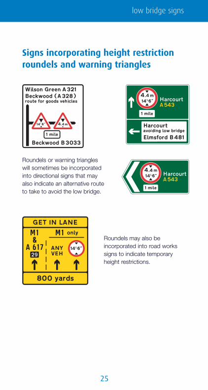
Signs incorporating height restrictionroundels and warning triangles
Roundels or warning triangleswill sometimes be incorporatedinto directional signs that mayalso indicate an alternative routeto take to avoid the low bridge.
Roundels may also beincorporated into road workssigns to indicate temporaryheight restrictions.
low bridge signs

��
Bells suspended over the road at a railway crossing to give an audible warning to drivers of vehicles that exceed the safe height beneath electrified overhead cables
At automatic level crossings, drivers of large or slow vehicles must phone before and after crossing
Long low vehicles may be at risk of grounding; drivers of such vehicles must phone before crossing
Plate used with level crossing warning signs: advance warning of light signals at a level crossing with or without a gate or barrier
Level crossing with a gate or barrier
Electrified overhead cable and the safe height beneath it (usually associated withan overhead electrified railway or tramway). On the approach to a junction, the plate may include an arrow to indicate the direction of the level crossing
Level crossing without a gate or barrier
Level crossing signs and signals
Before the crossing
��
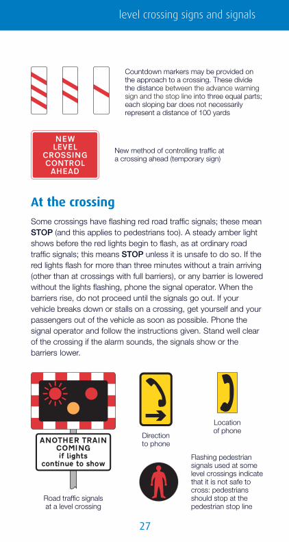
Countdown markers may be provided on the approach to a crossing. These divide the distance between the advance warning sign and the stop line into three equal parts; each sloping bar does not necessarily represent a distance of 100 yards
New method of controlling traffic at a crossing ahead (temporary sign)
Direction to phone
Location of phone
Flashing pedestrian signals used at some level crossings indicate that it is not safe to cross: pedestrians should stop at the pedestrian stop line
Road traffic signals at a level crossing
At the crossingSome crossings have flashing red road traffic signals; these meanSTOP (and this applies to pedestrians too). A steady amber lightshows before the red lights begin to flash, as at ordinary roadtraffic signals; this means STOP unless it is unsafe to do so. If thered lights flash for more than three minutes without a train arriving(other than at crossings with full barriers), or any barrier is loweredwithout the lights flashing, phone the signal operator. When thebarriers rise, do not proceed until the signals go out. If yourvehicle breaks down or stalls on a crossing, get yourself and yourpassengers out of the vehicle as soon as possible. Phone thesignal operator and follow the instructions given. Stand well clearof the crossing if the alarm sounds, the signals show or thebarriers lower.
level crossing signs and signals

��
Yellow box markings indicate an area of carriageway at a level crossing that must be kept clear. Do not enter the box if other stationary traffic may cause you to stop with any part of your vehicle within the box
Name of level crossingand phone number for contacting the railway operator (at level crossings without a dedicated phone)
Place where drivers of largeor slow vehicles should parknear a level crossing whilecontacting the signal operator
Amber lights and audible warnings followed by flashing red lightswarn that a train is approaching and that the barriers are about tocome down. You must STOP. The red lights flash all the time thebarriers are down, but the audible warning might stop. If anothertrain is approaching, the barriers will stay down; the lights willcontinue to flash and, if there is an audible warning, the sound willchange.
Automatic half-barrier level crossings

��
Automatic open level crossings have flashing signals and audible warnings. The lightswill flash and the warnings will sound until it is safe to cross
If there is more than one railway line over an automatic crossing, this signal will also flash and the sound of the audible warning will change if another train is approaching
Open level crossings without gates, barriers or road traffic light signals have "give way" signs over a symbol of a railway locomotive
RedGreen
STOPClear
IF NO LIGHT PHONE SIGNALMAN
Level crossings with miniature warninglights
Open level crossingsThe St Andrew’s cross is used at level crossings where there areno gates or barriers. At automatic crossings, you must alwaysSTOP when the traffic light signals show. At crossings with"give way" signs, always look out for and give way to trains.
These level crossings have gatesor barriers but no attendant. Theminiature red and green lights areoperated by an approaching train. Fulldirections for using these crossings aregiven on roadside signs. You muststop even if the gates or barriers havebeen left open. Always close the gatesor barriers after crossing.
level crossing signs and signals

�0
Route for trams only (and buses where the upper sign also includes the bus symbol)
Warning of trams crossing the road ahead
Indication of a tram-only route at a junction ahead
Drivers of other vehicles must give way to trams at level crossings without barriers, gates or road traffic light signals. Sometimes just a "give way" sign and a tram plate may be used
Reminder to pedestrians to look out for trams approaching from both directions
Road markingindicating the start of a route for trams only (and buses when varied to TRAM & BUS ONLY)
Tram signs, signals and roadmarkingsTrams can run on roads used by other vehicles and pedestrians.The part of the road used by trams (the "swept path") may have adifferent colour or textured surface to the rest of the road, or itmay be edged with special road markings. Keep the "sweptpath" clear. Trams cannot move out of the way of other roadusers!

�1
Examples of signs, signals and road markings for tram drivers
Stop line for trams at traffic signals where that part of the road is not used by other vehicles
Speed limit sign for tram drivers shown in kilometres per hour. All diamond-shaped signs are for tram drivers only
Stop Stop unless it is unsafe to do so
Proceedahead
Proceedright
Proceedleft
The signal mounted to the right gives instructions totram drivers; these instructions may not be the same as those given to drivers of other vehicles
tram signs, signals and road markings

��
No vehicles designed to carry more than8 passengers (excluding driver) or local buses
With-flow bus lane ahead that can also be used by pedal cycles and taxis. Hours of operation may be shown
With-flow bus and pedal cycle lane sign showing hours of operation
Route for buses and pedal cycles only (cycles not admitted when cycle symbol not shown; taxis admitted when "taxi" shown in upper sign)
The word "local" on the bus symbol means the only buses that may use the lane are those running a local service. Where the word "local" is not shown, the lane may be used by any vehicle designed to carry more than 8 passengers, excluding the driver, and local buses. Solo motorcycles may use the lane where the motorcycle symbol is shown on the signs (see page 141). Other vehicles may enter and stop in a bus lane to load and unload unless signs alongside the lane indicate otherwise.
Road markingindicating the startof a route for buses only. TAXI and/or the cycle symbol may be included
Bus laneroad marking
Traffic may use both lanes at the end of a bus lane
Bus and cycle signs and roadmarkings

��
Where there is a break in a bus lane at a junction, other traffic may use the left-hand lane for turning left only
Bus lane on road at junction ahead
End of bus lane
Road marking for a contra-flow bus lane that is also used by pedal cycles
Contra-flow bus lane (the upward arrows indicate the number of traffic lanes available)
Reminder to pedestrians to look out for buses or buses and pedal cycles approaching from the right
Contra-flow bus and pedal cycle lane on road at junction ahead
Parking place for buses only (no time limit)
Parking place for buses only, during times shown (with time limit)
bus and cycle signs and road markings

��
Stopping place for buses
Stopping place for tourist buses to allow passengers to take photographs
Plates used to indicate exemptions for buses, taxis and pedal cycles from prohibitions such as turn left ahead and no left turn. These signs may be circular when mounted in combination with traffic signals
Stopping by vehicles other than local buses prohibited during the times shown
Place where local buses may stand, from which all other vehicles are prohibited during the times shown
Edg
e of
car
riage
way
Bus stopin a lay-by
Edge
of
carr
iage
way
Bus stop
The broad continuous yellow line at the edge of the carriageway means that other vehicles are prohibited from stopping
Entrance to a bus station, depot or garage

��
Route recommendedfor pedal cycleson the main carriagewayof a road. Thismay be markedas an advisorypedal cycle lane
Mandatorywith-flow pedalcycle lane ahead. Hours of operation may be shown
Road markings for an advisory pedal cycle lane. Other vehicles should not use this part of the carriageway unless it is unavoidable
Reminder to pedestrians to look out for pedal cycles approaching from the right
Mandatory contra-flow pedal cycle lane (the upward arrows indicate the number of traffic lanes available)
Contra-flow pedal cycles in a one-way street (other than a mandatory contra-flow cycle lane). This may be marked by a broken line on the carriageway or there may be no line at all
Mandatory with-flow pedal cycle lane.Other vehicles must not use this part ofthe carriagewayexcept to pick up or set down passengers.Hours of operation may be shown
Road markings for a mandatory pedal cycle lane
Pedal cycle lane on road at junction ahead or (where "lane" is varied to "track") cycle track crossing road at junction ahead
End of cycle lane, track or route
Road marking indicating theend of a cycle lane, track or route
bus and cycle signs and road markings
��
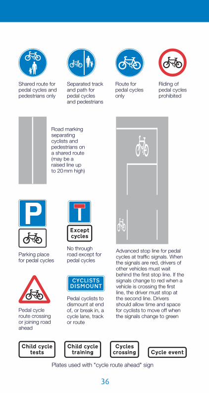
Advanced stop line for pedal cycles at traffic signals. When the signals are red, drivers of other vehicles must wait behind the first stop line. If the signals change to red when a vehicle is crossing the first line, the driver must stop at the second line. Drivers should allow time and space for cyclists to move off when the signals change to green
Pedal cycle route crossing or joining road ahead
Pedal cyclists to dismount at end of, or break in, a cycle lane, track or route
Road marking separating cyclists and pedestrians ona shared route (may be a raised line up to 20 mm high)
Plates used with "cycle route ahead" sign
Separated track and path for pedal cyclesand pedestrians
Shared route for pedal cycles and pedestrians only
Riding of pedal cycles prohibited
Route for pedal cycles only
No through road except for pedal cycles
Parking place for pedal cycles

��
The yellow panels indicate that there are waiting restrictions within the zone
Signs without yellow panels are used where access may be more restrictive and where waiting restrictions, if any, are indicated by yellow lines within the zone
All vehicles, including ridden pedal cycles, prohibited. (The hours during which apart-time zone operates will be shown in this panel and exemptions in a lower panel)
Ridden pedal cycles permitted within the zone. (The hours during which apart-time zone operates will be shown in this panel and exemptions in a lower panel)
Pedestrian zone signsAreas such as shopping streets may be signed as "pedestrianzones". Depending on the extent of the vehicle entry restrictions,such areas may be paved without the usual separation betweenfootway and carriageway and may not have yellow lines and kerbmarkings to indicate waiting and loading restrictions. Insteadrestrictions are detailed on zone entry signs and repeater plates.The entry signs may indicate that buses, taxis, disabled badgeholders or permit holders may enter the zone. Various examplesof zone entry signs are shown below.
pedestrian zone signs

��
Example of a variable message zone entry sign showing alternative displays for the middle panel (exemptions)
Two examples of waiting restriction repeater signs within the zone. (There may be no yellow lines or kerb markings)
At the end of the zone, a "zone ends" sign will be displayed. The prohibitory roundel in the upper panel will be a grey version ofthe roundel shown on the entry sign
Where different entry restrictions apply at different times of theday, and these restrictions are too complicated to show on thezone entry sign, a sign that can change its display (a variablemessage sign) may be used. It is therefore important always tocheck the restrictions in force before entering the zone.

��
On-street parking control signsand road markings
Waiting restrictionsWaiting restrictions are indicated byboth signs and road markings. Therestrictions usually apply to thewhole of the highway, includingverges and footways. Drivers maystop to pick up or set downpassengers and, where notprohibited, to load and unload.Disabled blue badge holders canusually park for up to three hoursor, in Scotland, without a time limit(see The Blue Badge Scheme –Explanatory Book published by theDepartment for Transport; visitwww.dft.gov.uk).
Yellow lines along the edge of thecarriageway, parallel to the kerb,indicate that restrictions are inforce. In environmentally sensitiveareas, a pale shade of yellow maybe used and the width of the linesmay be reduced. Except incontrolled parking zones (see
page 52), small yellow plates are normally erected adjacent tothe carriageway to give details of the times of operation of therestrictions. Where the yellow plate does not indicate the days ofthe week, the restrictions apply at the same times every day,including Sunday. If a bank holiday falls on a day when therestrictions are in operation, the restrictions apply in the normalway unless the plate states that they do not. Special restrictionsmay apply on days when a large event is being held at a nearbystadium or arena; these will also be shown on the plates.
Waiting prohibited 24 hours a day, 7 days a week, for at least 4 consecutive months. Yellow plates are no longer used where the restriction applies all year round
Waiting prohibited between times shown on the sign
on-street parking control signs and road markings

�0
This "no waiting" sign is used on portable signs to mark temporary waiting restrictions
Length of road to be kept clear of stationary vehicles, at entrances to off-street premises or where the kerb is dropped to provide a convenient crossing place for pedestrians
A double yellow line means no waiting at any time. Theaccompanying yellow plate, "no waiting at any time", is graduallybeing phased out. Where the "at any time" restriction applies foronly part of the year (e.g. during the summer months at a holidayresort) and is for at least four consecutive months, double yellowlines are used with plates giving the dates that the restrictionsapply. Waiting restrictions that apply for a shorter period or foronly part of the day or week are indicated by a single yellow line.
Loading restrictionsWhere loading restrictions apply in addition to waiting restrictions("loading" means both loading and unloading), these are indicatedby both yellow kerb marks and white plates. These plates may becombined with the yellow "no waiting" plates. As the marks areplaced intermittently along the kerb, a white plate is normallyerected at the first mark (where the loading restriction begins)and may include an arrow indicating the direction along the roadin which the loading restriction applies. Where a white plate doesnot indicate the days of the week, the restrictions apply at thesame times every day, including Sunday. If a bank holiday fallson a day when the restrictions are in operation, the restrictionsapply in the normal way unless the plate states that they do not.

�1
No waiting at any time during the summer months in the direction of the arrow. No waiting at any time throughout the year in the opposite direction (no yellow plate required). The changeover point is indicated in the carriageway by the transverse mark on the double yellow lines
Special restrictions may apply ondays when a large event is beingheld at a nearby stadium or arena;these will also be shown on theplates. Disabled blue badgeholders may not park whenloading restrictions are in force.
A double kerb mark means noloading at any time and is alwayssupplemented by a "no loading atany time" plate. Where the "at anytime" restriction applies for onlypart of the year (e.g. during thesummer months at a holidayresort) and is for at least fourconsecutive months, double kerbmarks are used with plates givingthe dates that the restrictionsapply. Loading restrictions thatapply for a shorter period or foronly part of the day or week areindicated by a single kerb mark.
Loading prohibited 24 hours a day, 7 days a week, for at least 4 consecutive months. The plate should include dates if the restriction does not apply throughout the year
Loading prohibited between times shown on the sign
Examples of waiting and loadingrestriction signs and markings
on-street parking control signs and road markings

��
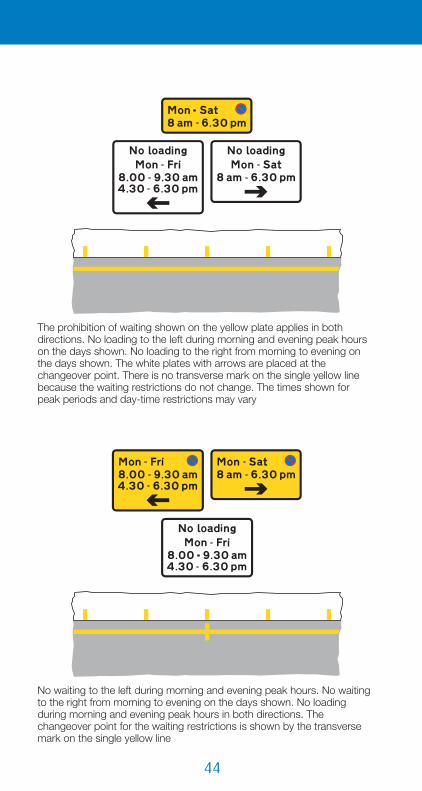
No waiting at any time throughout the year in both directions. No loading to the left during the days and times shown. No loading at any time throughout the year in the opposite direction. The white plates with arrows are placed at the changeover point. There is no transverse mark on the double yellow line because the waiting restrictions do not change
No waiting and loading to the left during morning and evening peak hours on the days shown. No waiting and loading to the right from morning to evening on the days shown. The changeover point for the waiting restrictions is shown by the transverse mark on the single yellow line. The times shown for peak periods and day-time restrictions may vary

��
No waiting to the left during the days and times indicated. Loading is permitted at all times in this direction. Waiting and loading prohibited to the right at all times throughout the year
The prohibition of waiting shown on the upper yellow panel on the plate applies in both directions. The prohibition of loading shown on the lower white panel of the plate applies only in the direction of the arrow. In the other direction, loading is permitted at all times. The arrow applies only to the white panel on which it is placed, not to the whole plate. There is no transverse mark on the single yellow line because the waiting restrictions do not change
on-street parking control signs and road markings
��
The prohibition of waiting shown on the yellow plate applies in both directions. No loading to the left during morning and evening peak hours on the days shown. No loading to the right from morning to evening on the days shown. The white plates with arrows are placed at the changeover point. There is no transverse mark on the single yellow line because the waiting restrictions do not change. The times shown forpeak periods and day-time restrictions may vary
No waiting to the left during morning and evening peak hours. No waiting to the right from morning to evening on the days shown. No loading during morning and evening peak hours in both directions. The changeover point for the waiting restrictions is shown by the transverse mark on the single yellow line

��
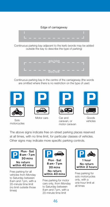
Edge of carriageway
Parking bay with individual spaces (parallel to the kerb)
Edge of carriageway
Parking bay with individual spaces (echelon)
On-street parking placesOn-street parking places may be designated for a particularclass of vehicle (e.g. solo motorcycles) or for a particular user(e.g. permit holders or disabled badge holders). Parking may befree or paid for (e.g. "pay and display" or parking meters). Theremay be a time limit on the period of stay and a minimum timebefore returning to a particular parking place. Some bays may bedesignated for use by more than one class of vehicle or user,either at the same time or at different times during the day.
Bays are generally marked in white, and are either continuous ordivided into individual spaces. They may include words on thecarriageway indicating the use of the bay (e.g. DISABLED). Platesare normally erected adjacent to the carriageway to give details ofthe parking controls. Where a plate does not indicate the days ofthe week, the restrictions apply at the same times on every day,including Sunday. Where the time of day is not shown, thecontrols apply for 24 hours. If a bank holiday falls on a day whenthe controls are in operation, the controls apply in the normal wayunless the plate states that they do not. Special controls mayapply on days when a large event is being held at a nearbystadium or arena; these will also be shown on the plates.
on-street parking control signs and road markings
��
Edge of carriageway
Continuous parking bay adjacent to the kerb (words may be added outside the bay to describe the type of parking)
Continuous parking bay in the centre of the carriageway (the wordsare omitted where there is no restriction on the type of user)
Solo motorcycles
Motor cars Car and caravan, or motor caravan
Goods vehicles
Free parking for all vehicles from Monday to Saturday between8 am and 7 pm, with a 20-minute time limit(no limit outside those times)
Free parking for solo motorcycles only, with aone-hour limit atall times
Free parking for motor cars only, from Monday to Saturday between8 am and 7 pm, with a 20-minute time limit
The above signs indicate free on-street parking places reservedat all times, with no time limit, for particular classes of vehicles.Other signs may indicate more specific parking controls.

��
Parking for holders of permit "A2" only, from Monday to Saturday between8 am and 6 pm
Parking for permit holders only, at all timesParking for disabled
badge holders only, at all times. Older signs may still show the orange badge symbol; these should be replaced by the end of 2009
On-street pay and display parking(the arrow points towards the ticket machine). Days of the week and time periods may be added to indicate when parking must be paid for
Location of ticket machine for on-street pay and display parking Reminder to
pay and display at on-street parking place
Pre-paid voucher parking only, from Monday to Saturday between 9 am and 6 pm, with a two-hour time limit (lower panel may give details of voucher)
on-street parking control signs and road markings

��
The upper panel indicates that waiting is prohibited during the morning and evening peak hours (a single yellow line will run through the bay). The lower panel indicates time-limited parking on Monday to Saturday between 10 am and 4 pm. Between 6 pm and 8 am the next day, and all day Sunday, there are no restrictions on parking
This sign indicates a parking place provided for doctors during the day-time, with a prohibition of waiting between 6.30 am and8 am (a single yellow line will run through the bay). These restrictions apply from Monday to Friday, with the bay also reserved for doctors on Saturday between 8.30 am and 3 pm
The top panel indicates that waiting is prohibited during the morning and evening peak hours (a single yellow line will run through the bay). The middle panel indicates that loading and unloading are also prohibited during the peak hours (there will be yellow kerb marks alongside the bay). The bottom panel indicates that the bay is used for pay and display parking on Monday to Saturday between 9.30 am and 4.30 pm. Between6.30 pm and 7.30 am the next day, andall day Sunday, there are no restrictions on parking or loading
Where parking-place controls do not operate at all times, anyvehicle may park in the bay without payment or time limit unlessother restrictions are indicated on the signs.

��
The top panel indicates that the parking controls apply from Monday to Saturday. Between 7 am and 8 am, and between 7 pm and 9 pm, the parking bay may be used only by permit holders. Between 8 am and 7 pm, the bay may be used by permit holders with no time limit, or by any other vehicle with a20-minute time limit. At all other times andon Sunday the bay may be used by any vehicle without any time limit
The parking controls apply from Monday to Saturday between 7.30 am and 6.30 pm. During these times the bay may be used by permit holders, with no time limit, or by any other vehicle with a 20-minute time limit
The parking bay is reserved for permit holders, without time limit, at all times.Other vehicles may also use the bay,but only from Monday to Saturday between 10 am and 4 pm, with a 20-minute time limit
Parking bays may be reserved for more than one type of user –at the same time, at different times, or a combination of both.
on-street parking control signs and road markings

�0
Vehicles may be parked partially on the verge or footway
Vehicles may be parked wholly on the verge or footway
End of verge or footway parking
Vehicles may be parked partially on the verge or footway during the times shown
Vehicles may be parked partially on the footway in marked bays only
Parking for permit holders only in the street or streets beyond this sign, during the times shown
Although vehicles should not generally be parked on verges andfootways (it is unlawful in London and some other cities), this maybe allowed on certain narrow streets where parked vehicleswould not obstruct pedestrians. There are special signs toindicate footway parking. There may also be white bays indicatingwhere parking is permitted. Where there are controls applying tothe parking place, such as pay and display, these should beindicated by separate signs.
Some residential streets, particularly culs-de-sac, which arereserved for permit holder parking only may not have any signsor bay markings within them, except possibly for a few repeaterplates. A sign at the entrance to the street will indicate thatparking is for permit holders only.
�1
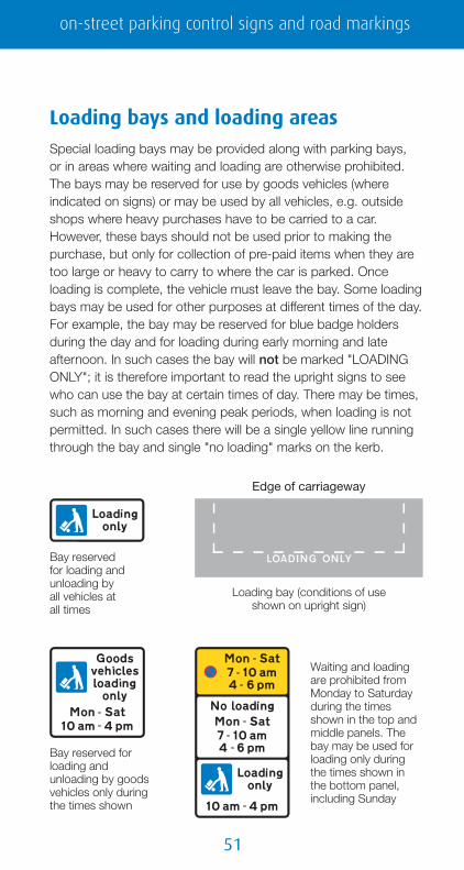
Bay reserved for loading and unloading by all vehicles at all times
Bay reserved for loading and unloading by goods vehicles only during the times shown
Waiting and loadingare prohibited from Monday to Saturday during the times shown in the top and middle panels. The bay may be used for loading only during the times shown in the bottom panel, including Sunday
Loading bay (conditions of useshown on upright sign)
Edge of carriageway
Loading bays and loading areasSpecial loading bays may be provided along with parking bays,or in areas where waiting and loading are otherwise prohibited.The bays may be reserved for use by goods vehicles (whereindicated on signs) or may be used by all vehicles, e.g. outsideshops where heavy purchases have to be carried to a car.However, these bays should not be used prior to making thepurchase, but only for collection of pre-paid items when they aretoo large or heavy to carry to where the car is parked. Onceloading is complete, the vehicle must leave the bay. Some loadingbays may be used for other purposes at different times of the day.For example, the bay may be reserved for blue badge holdersduring the day and for loading during early morning and lateafternoon. In such cases the bay will not be marked "LOADINGONLY"; it is therefore important to read the upright signs to seewho can use the bay at certain times of day. There may be times,such as morning and evening peak periods, when loading is notpermitted. In such cases there will be a single yellow line runningthrough the bay and single "no loading" marks on the kerb.
on-street parking control signs and road markings

��
Entrance toa loading area
Repeater sign within a loading area
End ofloading area
Off-highway areas may be designated "loading areas" wherewaiting is restricted except by permitted vehicles. Signs are usedwithout road markings to indicate this.
Controlled parking zonesSome areas are designated as controlledparking zones. The entry sign indicates thetimes when waiting is prohibited. Theyellow lines within the zone do notnormally have yellow plates indicatingthe times of the prohibition unless thetimes are different from those shown onthe entry sign. It is therefore important tonote the times shown when entering thezone. If there is no lower panel showingdays and times, the zone operates at alltimes. If loading is prohibited at the sametime as the waiting prohibition, the entrysign should include the words "No loading"at the bottom of the upper panel. The zoneis likely to include parking places andloading bays. Some parking places may befor permit holders only, others for generaluse. The times when these operate shouldbe shown on the signs at the bays; thesetimes may not be the same as thoseshown on the zone entry sign. Where themajority of on-street parking within thezone is pay and display, the heading on theentry sign may say "Pay and DisplayZONE" instead of "Controlled ZONE".
Entrance to acontrolled parking zone
End of controlled or voucher parking zone

��
Entrance to avoucher parking zone
Sign at a parking bay within a disc zone. Free parking for all vehicles, with a 30-minute time limit from Monday to Saturday between 8 am and 6 pm. A parking disc indicating the time of arrival at the parking bay must be displayed in the vehicle
Repeater sign indicating the times when waiting by goods vehicles over the maximum gross weight shown is prohibited Zone exit
Other headings might be "Meter ZONE" where there are parkingmeters, or "Disc ZONE" where a parking disc showing the time ofarrival has to be displayed on the vehicle when parking. The entrysign to a pre-paid voucher parking zone includes the voucherlogo.
In some areas, local authorities operate special goods vehiclewaiting restrictions. Usually these apply to goods vehicles of over5 or 7.5 tonnes maximum gross weight. Where the samerestrictions apply throughout a zone, usually overnight, the timesare indicated on a zone entry sign. Within the zone there are noyellow lines (unless there are other waiting restrictions applying toall vehicles), but there should be repeater signs on each side ofevery street as a reminder. There are equivalent signs for buses
with the bus symbol, and signs that applyto both goods vehicles and buses.
Zone entry
on-street parking control signs and road markings
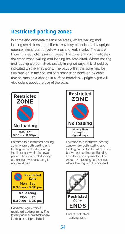
��
Entrance to a restricted parking zone where both waiting and loading are prohibited during the times shown in the lower panel. The words "No loading" are omitted where loading is not prohibited
Entrance to a restricted parking zone where both waiting and loading are prohibited at all times, but where parking and loading bays have been provided. The words "No loading" are omitted where loading is not prohibited
Repeater sign within a restricted parking zone. The lower panel is omitted where loading is not prohibited
End of restricted parking zone
Restricted parking zonesIn some environmentally sensitive areas, where waiting andloading restrictions are uniform, they may be indicated by uprightrepeater signs, but not yellow lines and kerb marks. These areknown as restricted parking zones. The zone entry sign indicatesthe times when waiting and loading are prohibited. Where parkingand loading are permitted, usually in signed bays, this should beindicated on the entry signs. The bays within the zone may befully marked in the conventional manner or indicated by othermeans such as a change in surface materials. Upright signs willgive details about the use of the bays.

��
Start of 24-hour clearway (no stopping on main carriageway at any time for the distance shown)
End of24-hour clearway
This sign is used on a 24-hour clearway where waiting is prohibited on the verge or footway in addition to the prohibition of stopping on the main carriageway. The words "on verge or footway" may be varied to "on verge" or "on footway". Where the "no waiting" symbol is replaced by the red cross, stopping on the verge or footway is prohibited
In built-up areas, urban clearways may be provided. During the times the urban clearway is in operation, stopping is not allowed on the carriageway or verges, except to pick up or set down passengers. There are no special road markings, but the signs are repeated throughout the length of the clearway
End of urban clearway
ClearwaysThe red cross means no stopping, not even topick up or set down passengers. The sign is usedto indicate a 24-hour clearway (usually on a ruralroad) or may be incorporated into other signs withthe words "No stopping" (e.g. the "no stopping
except local buses" sign at bus stops). On a 24-hour clearway,the prohibition of stopping applies only to the main carriageway.You may stop in a lay-by unless there are signs to say otherwise.A 24-hour clearway does not have any special road markings, butthere should be smaller repeater signs at approximately one mileintervals.
on-street parking control signs and road markings

��
Stopping in lay-by not allowed, except in an emergency (similar to hard shoulders on a motorway). This may not apply to the whole lay-by. The length over which stopping is prohibited will be indicated by double yellow lines. These lay-bys usually have an emergency telephone
Yellow zig-zag markings outside schools, hospitals or fire, police or ambulance stations indicate the length of road where you should not stop, not even to pick up or set down children or other passengers. Where there is an upright sign, there is a mandatory prohibition of stopping during the times shown. These markings are provided outside schools to ensure that children can see and be seen clearly when crossing the road
Double red lines mean no stopping at any time
Single red lines mean no stopping during the days and times shown on the upright sign
Red routesOn red routes, yellow waiting restriction lines are replaced by redlines that mean no stopping for any purpose, not even to pick upor set down passengers, other than by a licensed taxi. A driver ofa vehicle displaying a blue badge may stop to pick up or setdown a disabled person, but must not park.

��
A bay marked with white broken lines means that it is available for use at all times that the red route "no stopping" rule applies. The upright sign shown in this example means thatthe bay is reserved for blue badge holders, with a maximum stay of 3 hours
A bay marked with red broken lines means that it is available for use for only part of the time that the red route "no stopping" rule applies.The bay must not be used from Monday to Saturday between 7 am and 10 am nor between 4 pm and7 pm. In this example, the bay may be used for loading/unloading (max stay 20 minutes) and by blue badge holders (max stay 3 hours), during the times shown in the bottom panel
The prohibition of stopping applies to the whole road, includingthe verge and footway, during the times shown on upright signsthat face oncoming traffic. Special bays marked on thecarriageway may be provided for parking or loading; theconditions that apply to these will be indicated on upright signsthat should also face oncoming traffic.
on-street parking control signs and road markings
��
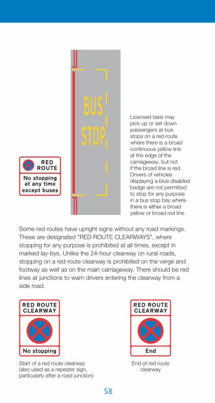
Licensed taxis maypick up or set down passengers at busstops on a red route where there is a broad continuous yellow lineat the edge of the carriageway, but notif the broad line is red. Drivers of vehicles displaying a blue disabled badge are not permitted to stop for any purposein a bus stop bay where there is either a broad yellow or broad red line
Start of a red route clearway (also used as a repeater sign, particularly after a road junction)
End of red route clearway
Some red routes have upright signs without any road markings.These are designated "RED ROUTE CLEARWAYS", wherestopping for any purpose is prohibited at all times, except inmarked lay-bys. Unlike the 24-hour clearway on rural roads,stopping on a red route clearway is prohibited on the verge andfootway as well as on the main carriageway. There should be redlines at junctions to warn drivers entering the clearway from aside road.

��
No stopping in taxi rank during the times shown. The bay includes a broad continuous line to indicate the prohibition of stopping
No waiting in taxi rank during the times shown
Taxi ranksTaxi ranks usually have yellow bays marked with the word"TAXIS". Where the bay is used for other purposes (e.g. loadingand unloading) at a different time of day, the bay will be whitewithout any words. Either waiting or stopping will be prohibitedwithin a taxi rank. Where stopping is prohibited, the bay includesa broad continuous yellow line at the edge of the carriageway.Where waiting is prohibited in taxi ranks, yellow "no waiting" linesare provided where waiting is also prohibited at other times, orwhere the bay marking is white because it has shared use. Yellowupright signs show the times when waiting or stopping isprohibited in the rank.
on-street parking control signs and road markings

�0
Waiting is prohibited at all times (indicated by double yellow lines). The taxi rank operates from 11 pm to 5 am every day
The taxi rank operates every day between 10 am and 4 pm. Waiting is otherwise prohibited from 8 am to 6 pm every day, and loading is prohibited during the morning and evening peak hours from Monday to Friday

�1
The sign shows the times when the bay is used as a taxi rank (overnight) and when it is used for loading by goods vehicles (during the day from Monday to Saturday). At other times there are no restrictions on parking. The single yellow line is replaced by a broad yellow line if stopping by other vehicles is prohibited during the times the bay is used by taxis.This will be indicated in the upper panel of the sign, where the "no waiting" symbol is replaced by the red cross and the words "No waiting" variedto "No stopping"
Information boards may be provided at taxi ranks
on-street parking control signs and road markings

��
Centre line on a single carriageway road
Lane line separating traffic travelling in the same direction (single or dual carriageway road)
Hazard warning line (replaces a centre lineor a lane line). An upright sign may indicate the nature of the hazard,such as a bend. The marking is used also on the approach to a junction
Diagonal white lines (hatched markings) bounded by broken lines may be used in the centre of the road to separate opposing flows of traffic. They are often provided at junctions to protect traffic turning right. They may also be used on the approach to a central traffic island or the startof a dual carriageway. Hatched markings with a single, broken boundary line may be usedat the edge of the road or next to the central reservation of a dual carriageway: the diagonal lines always slope towards the direction of travel. You should not enter any hatched area bounded by a broken line unless it is safe to do so
Road markings
Along the road

��
Part of the carriageway where traffic passes in the same direction on either side of the chevron marking. Vehicles should not enter the area unless safe to do so. This marking is likely tobe found in one-way streets with central islands and where an exit lane leaves at a junction
Part of the carriagewaywhere traffic passes in the same direction on either side of the chevron marking. The continuous boundary line means that vehicles mustnot enter the area except in an emergency. This markingis used where slip roadsleave and join motorways andmany dual carriageway roads. It is also used for segregatedleft-turn lanes at roundabouts
Arrow indicating the direction in which to pass hatched markings and double white lines, or the route that high vehicles should take under a low arch bridge (may be reversed)
Reduction in the number of lanes, or area not available to traffic. Vehicles must not cross the continuous white line except in an emergency. Used on the right-hand side of a motorway, dual carriageway road or slip road
road markings

��
Some double continuous white lines have narrow areas of hatched lines within them or a wider area of hatching to the side. You must not cross a continous white line to enter a hatched area
Double white linesThese are used to prevent overtaking where visibility is restricted,and to separate opposing traffic flows on steep hills with climbinglanes. Double continuous lines are also sometimes used on othersingle carriageway roads that have two lanes in at least onedirection. Viewed in the direction of travel, if the line closest to youis continuous, you must not cross or straddle it (except to turninto or out of a side road or property, avoid a stationary vehicleblocking the lane, or overtake a pedal cycle, horse or road worksvehicle moving at not more than 10 mph). Where the line closestto you is broken, you may cross the lines to overtake if it is safe todo so. Stopping is prohibited on any length of road that hasdouble white lines, even if the line on that side of the road isbroken. The exceptions are stopping to pick up or set downpassengers, or to load or unload. In these circumstances, youshould park off the main carriageway wherever possible.

��
Edge of carriageway, other than at junctions, exits from private drives and lay-bys. Used on the left-hand side of the road and alongside the central reservation of dual carriageway roads
Side
ele
vatio
n
Alternative edge of carriageway marking, with raised ribs to provide audible and tactile warnings when the line is being crossed. They are used on motorways and other roads with hard shoulders or hard marginal strips
Edge of main carriageway at a junction (particularly where a slip road leaves or joins), at an exit from a private drive or at a lay-by. Also used to divide the main carriageway from a traffic lane that leaves the main carriageway at a junction ahead (lane drop)
Edge of main carriageway at a junction or at an exit from a private drive. Used in conjunction with "give way" markings on the side road
Along the edge of the road
road markings

��
Road junction with a right-turn lane
Motorway or dual carriageway road with exit and entry slip roads
Diverge arrow indicating an exit slip road or the start of a lane for turning traffic (may be reversed)
Do not cross chevron markings with a continuous boundary line
Hatched area to protect turning traffic. Drivers should not enter unless it is safe to do so
See "Regulatory signs" for "give way" (and "stop") priority junctions
At junctions

��
Where stationary traffic would be likely to block a junction, a yellow box may be marked on the road, covering all or part of the junction. You must notenter the box if your exitis not clear. If turning rightat the junction, you may enter the box (behind otherright-turning vehicles, if any) to wait for a gap in the oncoming traffic, but onlyif the right-turn exit is clear
Junction with traffic signals
Crossing points for pedestrians
Stop line
Arrows indicating appropriate traffic lanes
Junction may have a yellow box (see below)
road markings

��
A mini-roundabout is normally found on a road with a speed limit of 30 mph or less. It should be treated the same as a conventional roundabout. You must give way to traffic fromthe right, and keep to the leftof the white circle unless the size of your vehicle or the junction layout makes drivingover it unavoidable
Mini-roundabout
Conventional roundabout
Some roundabouts have yellow bar markings on the approach. These become closer together the nearer to the roundabout and provide a warning to drivers to slow down
Single broken "give way" line
Some roundaboutsmay have lane markings to guide drivers to the appropriate exit andare often controlled by traffic signals

��
Some conventional roundabouts may have a segregated left-turn lane where drivers do not give way to traffic on the roundabout. This may be separated from the roundabout by either a solid island or chevron markings. Where the chevrons are bounded by continuous lines, vehicles must not enter the area except in an emergency. You should therefore choose the correct lane well before the roundabout. A directional sign in advance of the junction may show the segregated lane
Central island of roundabout
Segregatedleft-turn lane
Typical mini-roundabout junction
The "give way" line at a mini-roundabout is a broad broken line, but sometimes the conventional double line with the upright "give way" sign may be used
Mini-roundabout upright sign
The "give way" triangle is sometimes used in the carriageway
road markings

�0
Appropriate traffic lanes for different movements at junction ahead.A double-headed arrow is used where two different movements may be made from the same lane or where that lane divides into two or more lanes ahead (e.g. a lane with a combined "left" and "ahead" arrow may divide into a left-turn lane and an ahead lane)
Appropriate traffic lanes for particular destinations
Direction to be taken by traffic turning within a junction
Compulsory traffic movements at a junction ahead. These may apply to a specific traffic lane or to all traffic approaching the junction
Traffic lanes at junctions
�1
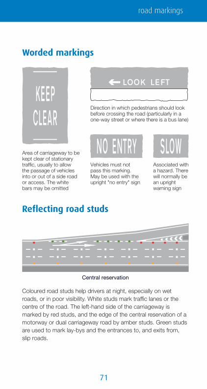
Vehicles must not pass this marking. May be used with the upright "no entry" sign
Associated with a hazard. There will normally be an upright warning sign
Area of carriageway to be kept clear of stationary traffic, usually to allowthe passage of vehicles into or out of a side road or access. The white bars may be omitted
Direction in which pedestrians should look before crossing the road (particularly in a one-way street or where there is a bus lane)
Central reservation
Worded markings
Reflecting road studs
Coloured road studs help drivers at night, especially on wetroads, or in poor visibility. White studs mark traffic lanes or thecentre of the road. The left-hand side of the carriageway ismarked by red studs, and the edge of the central reservation of amotorway or dual carriageway road by amber studs. Green studsare used to mark lay-bys and the entrances to, and exits from,slip roads.
road markings
��
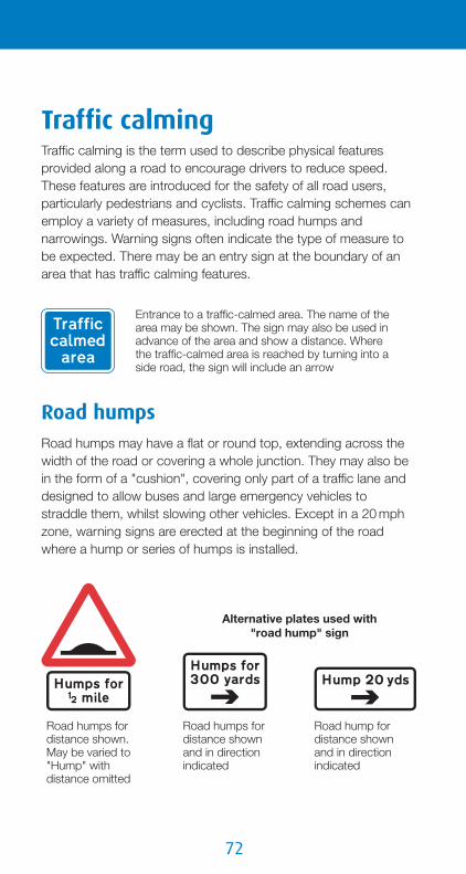
Road humps for distance shown. May be varied to "Hump" with distance omitted
Alternative plates used with "road hump" sign
Road humps for distance shown and in direction indicated
Road hump for distance shown and in direction indicated
Entrance to a traffic-calmed area. The name of the area may be shown. The sign may also be used in advance of the area and show a distance. Where the traffic-calmed area is reached by turning into a side road, the sign will include an arrow
Traffic calmingTraffic calming is the term used to describe physical featuresprovided along a road to encourage drivers to reduce speed.These features are introduced for the safety of all road users,particularly pedestrians and cyclists. Traffic calming schemes canemploy a variety of measures, including road humps andnarrowings. Warning signs often indicate the type of measure tobe expected. There may be an entry sign at the boundary of anarea that has traffic calming features.
Road humpsRoad humps may have a flat or round top, extending across thewidth of the road or covering a whole junction. They may also bein the form of a "cushion", covering only part of a traffic lane anddesigned to allow buses and large emergency vehicles tostraddle them, whilst slowing other vehicles. Except in a 20 mphzone, warning signs are erected at the beginning of the roadwhere a hump or series of humps is installed.

��
A road hump is normallymarked with white triangleand edge line markings.
Zebra andsignal-controlledpedestrian crossingsare sometimeslocated on flat-tophumps. These maybe indicated byadvance warningsigns.
Zebra crossing on a road hump
Signal-controlled pedestrian crossing on a road hump
Road narrowingsRoads may be reduced in width by the use of build-outs on oneor both sides. When placed on both sides, they may be oppositeeach other or staggered. Priority through the narrowing may becontrolled by signs and "give way" markings. It is essential thatyou obey signsindicating priorityto vehicles comingfrom the oppositedirection.
traffic calming

��
If priority is not given to either direction at a road narrowing, youshould ensure that you can pass through without endangeringoccupants in vehicles approaching from the other direction. Donot accelerate on the approach to a narrowing, but maintain aslow steady speed and be prepared to give way to approachingtraffic. Let any cyclists proceed ahead of you.
Warning signs indicatingwhich side the narrowingoccurs may be used inadvance, especially wherepriority signs and markingsare not provided.
Road narrowson left (right if symbol reversed)
Road narrowson both sides
Home ZonesHome Zones are residentialareas with streets designedto be places for people aswell as for motor traffic. Theroad space is shared amongdrivers and other road users.People could be using the
Entrance to a Home Zone
20 mph zonesSome traffic-calmed areasare indicated by the 20 mphzone entry sign. This sign, aswell as indicating a 20 mphspeed limit, warns drivers thatthey are entering an area withtraffic calming features, suchas road humps and roadnarrowings. These featuresmay not be individuallysigned, nor are there likely to
be 20 mph speed limit repeater signs. In these areas, it isimportant that you adopt a steady low speed and avoid repeatedacceleration and deceleration.
Entrance to a20 mph zone
End of 20 mph zone and start of 30 mph speed limit
��
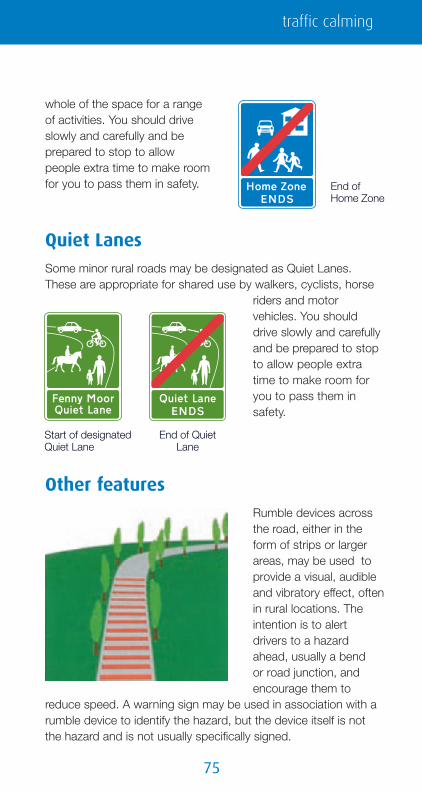
whole of the space for a rangeof activities. You should driveslowly and carefully and beprepared to stop to allowpeople extra time to make roomfor you to pass them in safety. End of
Home Zone
Other featuresRumble devices acrossthe road, either in theform of strips or largerareas, may be used toprovide a visual, audibleand vibratory effect, oftenin rural locations. Theintention is to alertdrivers to a hazardahead, usually a bendor road junction, andencourage them to
reduce speed. A warning sign may be used in association with arumble device to identify the hazard, but the device itself is notthe hazard and is not usually specifically signed.
Quiet LanesSome minor rural roads may be designated as Quiet Lanes.These are appropriate for shared use by walkers, cyclists, horse
riders and motorvehicles. You shoulddrive slowly and carefullyand be prepared to stopto allow people extratime to make room foryou to pass them insafety.
Start of designated Quiet Lane
End of Quiet Lane
traffic calming

��
Example of a village gateway
Gateways into villages may be formed from the combination ofspeed limit signs, yellow backing boards and village name plates.Central hatched markings or islands may also be used toseparate opposing traffic. Drivers approaching the gatewaysshould reduce speed and observe the speed limit all the waythrough the village.
Some parts of the carriageway may have a coloured surface toemphasise the road markings.

��
Motorway signs, signals androad markingsMost motorway signs have a blue background with whitelettering, numbers and borders, although tourist destination signs,as on other roads, have brown backgrounds (see page 84).
Special traffic regulations govern the useof motorways. These include no stopping(except, in an emergency, on the hardshoulder or verge), no U-turns and noreversing. Goods vehicles and buses(where a bus is a vehicle constructed to
carry more than eight seated passengers) with a maximum ladenweight of more than 7.5 tonnes, vehicles drawing trailers, andvehicles required to be fitted with a speed limiter, must not usethe right-hand lane of a motorway that has three or more lanes.Motorways must not be used by certain classes of traffic: learnerdrivers other than HGV, invalid carriages of less than 254 kgunladen weight, pedal cycles, motorcycles under 50 cc capacity,agricultural vehicles and vehicles incapable of attaining a speedof 25 mph on the level when unladen and not drawing a trailer.Pedestrians and animals are also prohibited.
To ensure that direction signs are absolutely clear to driverstravelling at motorway speeds, it is necessary to limit the numberof destinations shown. Your destination might not appear on themotorway signs: when planning a journey, it is advisable beforesetting off to check the junction number of the exit you require.Junctions can be identified by the number shown on a blackbackground in the bottom left-hand or top left-hand corner ofmotorway signs (or, in the case of overhead signs, in a separatepanel also indicating the distance to the junction). Junctionnumbers are usually shown on road maps, so it is easy to checkthese before starting your journey. On the motorway, thesenumbers can be used as a guide to your location. However, notall junctions have an exit in both directions, so numbers may notbe consecutive. Where new junctions have been constructed, thenumber may be followed by a letter (e.g. junction 23A).
Start of motorway regulations
motorway signs, signals and road markings
��
Blue direction signs, with the motorway symbol and large route numbers, indicate that a motorway or motorway slip road leads directly from a junction with an all-purpose road. The motorway junction number, shown on the black background, may not always be included
On the approach to a junction with a motorway, a direction sign on anall-purpose road has blue panels that include the motorway symbol.The panels may include the junction number on a black background.The name in capital letters is a regional destination
This sign, with the motorway numberin brackets on a blue background, but without the motorway symbol, indicates the route to take from a junction ahead in order to reach the motorway. The motorway is not accessed directly from this junction
A road other than a motorway is called an "all-purpose road". Atthe point where you join a motorway, a special symbol is used toindicate the start of motorway regulations. A direction sign on anall-purpose road will normally use this symbol to indicate amotorway slip road or the beginning of a motorway. Where a signshows a motorway route number on a blue background withoutthe symbol, the route indicated will normally be an all-purposeroad that you should follow to reach the motorway.
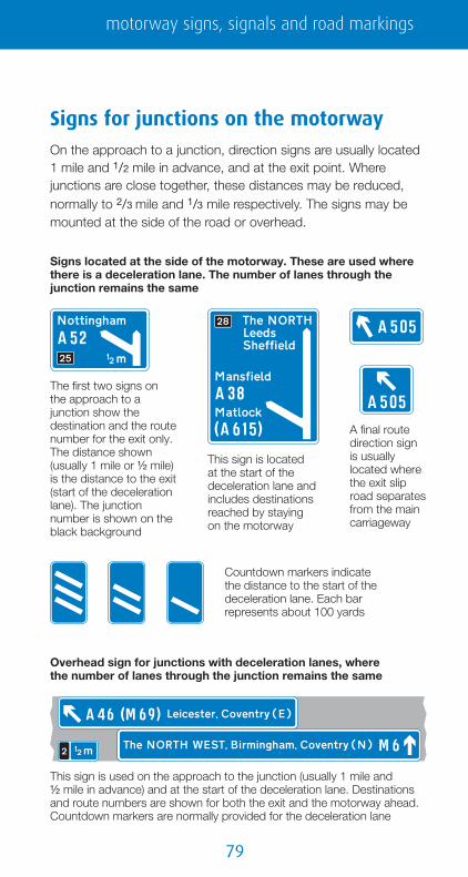
��
Signs located at the side of the motorway. These are used where there is a deceleration lane. The number of lanes through the junction remains the same
The first two signs onthe approach to a junction show the destination and the route number for the exit only. The distance shown (usually 1 mile or ½ mile) is the distance to the exit (start of the deceleration lane). The junction number is shown on the black background
This sign is located at the start of the deceleration lane and includes destinations reached by staying on the motorway
A final route direction signis usually located where the exit slip road separates from the main carriageway
Countdown markers indicate the distance to the start of the deceleration lane. Each bar represents about 100 yards
Overhead sign for junctions with deceleration lanes, wherethe number of lanes through the junction remains the same
This sign is used on the approach to the junction (usually 1 mile and½ mile in advance) and at the start of the deceleration lane. Destinations and route numbers are shown for both the exit and the motorway ahead. Countdown markers are normally provided for the deceleration lane
Signs for junctions on the motorwayOn the approach to a junction, direction signs are usually located1 mile and 1/2 mile in advance, and at the exit point. Wherejunctions are close together, these distances may be reduced,normally to 2/3 mile and 1/3 mile respectively. The signs may bemounted at the side of the road or overhead.
motorway signs, signals and road markings
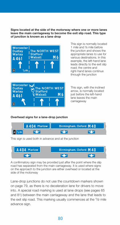
�0
Signs located at the side of the motorway where one or more lanes leave the main carriageway to become the exit slip road. This type of junction is known as a lane drop
This sign is normally located1 mile and ½ mile before the junction and shows the appropriate lanes to use for various destinations. In this example, the left-hand lane leads directly to the exit slip road; the centre andright-hand lanes continue through the junction
This sign, with the inclined arrow, is normally located just before the left-hand lane leaves the main carriageway
This sign is used both in advance and at the junction
Overhead signs for a lane-drop junction
A confirmatory sign may be provided just after the point where the slip road has separated from the main carriageway. It is used where signson the approach to the junction are either overhead or located at theside of the motorway
Lane-drop junctions do not use the countdown markers shownon page 79, as there is no deceleration lane for drivers to moveinto. A special road marking is used at lane drops (see pages 65and 81) between the main carriageway and the lane that leads tothe exit slip road. This marking usually commences at the 1/2 mileadvance sign.

�1
Overhead sign showing appropriate lanes for the different destinations
A sign mounted at the side of the motorway shows the arrangement of traffic lanes
Cen
tral
res
erva
tion
Some junction layouts may bemore complex and designed toallow a heavier flow of traffic toleave the motorway. A traffic lanemay be shared by traffic bothcontinuing ahead and leaving themotorway. This shared lane hasa deceleration lane separatedfrom a lane drop by chevron roadmarkings. In the example, theleft-hand lane is used for the exitslip road only, the centre lane isthe shared lane, and theright-hand lane is for aheadtraffic only. A sign mounted at theside of the motorway shows theroad layout. An overhead signshows the appropriate lanes touse for each destination.
motorway signs, signals and road markings

��
Other types of sign in advance of junctions
Where two junctions are very close, they may both be shown on the same sign, together with the distances and junction numbers. The sign that is located where the deceleration lane starts for the first exit (see page 79) will normally show the second exit place names and route number with the ahead destinations
Where the junction ahead is with another motorway, additional signs may be provided prior to the 1 mile advance sign
This overhead sign indicates a junction that has two exits. The first exit has a deceleration lane and is indicated by the upper part of the sign.The second exit is a lane drop. Traffic continuing along the motorway should use the centre and right-hand lanes
Signs showing lanes that join the main carriageway at junctions
The slip road joins the main carriageway as a lane gain to increase the number oflanes from two to three.A distance panel may be added
The right-hand lane of the slip road joins the main carriageway as a merge with an acceleration lane. This is followed by the left-hand lane which joins the main carriageway as a lane gain. Chevron road markings normally separate the two lanes on the slip road. The distance may be omitted
Sign for drivers on main carriageway
Sign for drivers on slip road
Sign for drivers on slip road
Sign for drivers on main carriageway

��
Motorway ends at a junction with anall-purpose road
Direction signs where the main carriageway of a motorway ends at a roundabout
Motorway ends at a junction with another motorway
Direction signs on exit slip roads (the green panels indicate a primary route; the white panels indicate a non-primary route)
Motorway-to-motorway junction with a roundabout (motorway regulations continue to apply)
Directions from junction ahead, usually controlled by traffic signals or a "give way" sign
Directions from a roundabout ahead
Appropriate lanes to use on the approach to the junction (sign located at the side of the slip road)
Appropriate lanes to use on the approach tothe junction (overhead sign over the slip road)
Appropriate lanes for turning movements at junction ahead
motorway signs, signals and road markings

��
Sign at the side of the main carriageway. There will usually be two of these in advance of the junction
Sign indicating a place with several tourist attractions. It is located at the side of the main carriageway on the approach to a junction
Sign on exit slip road indicating directions to tourist attractions from a roundabout ahead
Sign on exit slip road indicating directions to tourist attractions from a junction ahead
Where it is not practicable to provide tourist destination signs within 1 mile of a junctionor there are more destinations than can be accommodated on the signs, this sign maybe used in advance of the main 1 mile directionsign for the junction. It may also be used whenthe junction layout is complex (such as thatshown on page 81); "leave at Junction 24"is then varied to "follow" plus a destination
Signs for tourist destinationsTourist destinations are shown on signs with brown backgrounds.On the main carriageway of a motorway, these are separate fromthe main direction signs and are usually sited 3/4 mile and 1/4 milefrom the junction (although they do not show the distance to thejunction). On exit slip roads and where the motorway ends at aroundabout, the main direction signs may show touristdestinations on a brown panel, in the same way that they showother destinations on green and white panels (see page 83).However, separate brown signs are likely to be used at theselocations to avoid putting too much information on a single sign.See pages 100 to 102 for more information about tourist signs.

��
After each junction, a sign may show the distance to the next motorway service area
This sign may be used when there is a junction with another motorway before the next service area
About ½ mile before the service area (further if the services are at a junction), a sign informs drivers of the facilities available, and may include both the name of the operator and the geographical name. The price of fuel, if shown, is usually for a litre of unleaded petrol, indicated by the green pump symbol. The "LPG" symbol means that LPG fuel is available; the "i" symbol refers to an information point; the bed symbol indicates overnight accommodation
About 1 mile in advance of a service area, a sign may inform drivers of the availability of services ahead, including the names of the operators. It will normally show the next two services, and include services on other motorways if the junctions with those motorways are reached before the second service area. Where the first services are located at a junction, this sign is likely to be used about 2 miles in advance; the word "Services" may be added to the junction direction signs as an exit destination
Sign located at start of the deceleration lane for a service area with direct access from the motorway
Signs for motorway service areasOn most motorways, service areas are provided at intervals of notmore than 30 miles, half an hour at normal motorway drivingspeeds. These service areas are open 24 hours a day, every dayof the year, and provide fuel, free parking (up to 2 hours),refreshments, toilets and disabled access. Other facilities,including telephones, motels and tourist information, may also beprovided. Some motorway service areas are accessed directlyfrom the main carriageway, others via junctions with other roads,where they will also be available to non-motorway traffic.
motorway signs, signals and road markings

��
Alternative signs indicating the entrance to a servicearea accessed directly from a motorway. May be used to indicate the direction to a motorway service area located on an all-purpose road
Sign on motorway indicating that no servicesare available ahead. Drivers should leave the motorway if service facilities are required
Sign on all-purpose road indicating that no services are available on motorway ahead. The motorway number may include a compass point (e.g. "M 41(N)") if services are available in one direction but not the other
Motorway service area ahead on an all-purpose road (sign located off the motorway)
Direction or entrance to a motorway service area located on an all-purpose road (alternative signs)
Signs may be provided to indicate that services are not availableon the motorway.
Where a motorway service area issituated on an all-purpose road,the signs off the motorway,indicating the services, shouldhave a blue background (oldersigns may have a green or whitebackground). The geographicalname of the services may beshown on these signs, but notthe operator’s name (this isshown only on the signs on themotorway). The word "Services"may be incorporated into otherdirection signs, including the signon the exit slip road from themotorway. Where these signshave a green or whitebackground, the word "Services"(with or without a geographicalname) will normally be placed ona blue panel.

��
A route confirmatory sign is provided after most junctions. This shows the motorway number and the distances to the main destinations ahead
This sign indicates a slip road that leads to a maintenance compound and is not availableto the general public
Where there are more destinations than can be accommodated on the direction signs at a junction, a sign such as this may be used in advance of the 1 mile direction sign. It advises drivers of the route to be followed (or junction to leave at) for destinations that cannot be accommodated on the main junction sign
Where a motorway has been widened but the original bridges retained, there may be no hard shoulder under or over the bridge. Where this occurs, signs will indicate the distance over which this applies. There will be hatched markings on the hard shoulder at the point where it comes to an end
Marker posts, located at the back of the hard shoulder at100 metre intervals, show the direction to the nearest emergency telephone (housed in an orange box). You can use the telephone to contact the control centre in case of an emergency or breakdown
County boundary sign (may be varied to show the name of a river)
Observation platforms are sometimes provided at the back of the hard shoulder. These are reserved for authorised vehicles, such as those of the Highways Agency's Traffic Officers or the police
Other signs on motorways
motorway signs, signals and road markings

��
Cen
tral
res
erva
tion
Direction of route recommended for goods vehicles
This sign is located before the 1 mile advance sign for a junction ahead. It is used where it is not practicable to sign a goods vehicle routeat the junction itself
Direction signs for drivers of goods vehicles
Some motorways may have specialchevron markings in the centre of thetraffic lanes. These are spaced 40 metresapart, and keeping two marks betweenyour vehicle and the one in front willprovide a safe driving distance at 70 mph.There will be signs advising you to checkyour distance, keep two chevrons apartand keep your distance.

��
Signs indicating the end of motorway regulations
Sign located at the entrance to a service area accessed directly from the motorway, or a maintenance compound
Sign located where the motorway ends on either the main carriageway or exit slip road
Sign located on main carriageway to indicate the distance to the end of the motorway
Red lamps flashing from side to side in pairs, together with a red cross, mean"do not proceed in the traffic lane directly below". These signals are mounted above the carriageway: there is a signal for each traffic lane. A previous signal may direct you into an adjacent lane (see page 90). More than one lane may be closed to traffic
Motorway signals and variable signsThese advise of abnormal traffic conditions ahead (e.g. laneclosures or fog) and may indicate a speed limit. See Active TrafficManagement on page 91 for signs where the hard shoulder issometimes used as a traffic lane. Where variable speed limit signsare mounted over individual lanes and the speed limit is shown ina red ring (see page 20), the limit is mandatory. Speed limits thatdo not include the red ring are the maximum speeds advised forthe prevailing conditions.
Signals and variable signs may apply to individual lanes whenmounted overhead or, when located on the central reservation orat the side of the motorway, to the whole carriageway. They arenormally blank, but when they indicate a restriction the reasonmay not always be obvious. There may have been an accidentahead, so take no chances and obey the signals. When redlamps are flashing above your lane, you MUST STOP unlessyou can move safely to a lane where red signals are not showing.
motorway signs, signals and road markings

�0
Signals and variable signs above each lane of the motorway
Each lane has its own signal; each signal has two pairs of amber lamps that flash from top to bottom. You should obey the signal for your lane
Temporary maximum speed advised for prevailing traffic conditions
Move to adjacent lane (arrow may point downwards to the right)
Leave motorway at next exit
End of temporary restrictions
Risk of fog ahead Risk of ice ahead
Various lane closures (signs for carriageways with four, three or two lanes)
Signals and variable signs at the side of the motorway
These apply to the carriageway as a whole and are either located on the central reservation or mounted above the hard shoulder in combination with variable signs that display information about road works, congestion and diversions ahead. The amber lamps flash in pairs from top to bottom

�1
Risk of ice ahead
Risk of fog ahead
Leave motorway at next exit
Temporary maximum speed advised
End of temporary restrictions
Signals and variable signs at the entrance to a motorway
All lanes closed (signs for carriageways with four, three or two lanes). Do not enter the motorway when the red lamps are flashing in pairs from side to side
Older type of motorway signal
On some motorways, particularly in Scotland, you may encounter this type of signal mounted at the side of the carriageway. Flashing amber lamps indicate that thereis a hazard ahead. You should not exceed a speed of 30 mph until you have passed this hazard
Active Traffic ManagementA scheme has been introduced on part ofthe M 42 motorway, between the M 6 andM 40 near Birmingham, to allow traffic touse the hard shoulder as a traffic laneduring times of heavy congestion or whenthere has been an incident that blocks oneor more lanes. This is known as "ActiveTraffic Management".
Start of ActiveTraffic Management
motorway signs, signals and road markings

��
Each lane, including the hard shoulder, has overhead signals andsigns similar to those described on pages 89 and 90. Before thehard shoulder is made available to traffic, a speed limit will beapplied to the main carriageway. This will be the same for all lanesand will usually be 50 mph. The speed limit shown over each lanewill be in a red ring (see page 20) with no signals. There will be ared cross, with no signals, above the hard shoulder to indicatethat it is closed. When the hard shoulder is in use as a traffic lane,the red cross will change to a speed limit (the same as for theother lanes). Should it be necessary to close any lane, includingthe hard shoulder when it is in use as a traffic lane, a red crosswith red lamps flashing in vertical pairs will be shown above thatlane (see page 89). The previous signal will show an arrow,inclined downwards to the left or to the right, indicating that youshould move into the adjacent lane (see page 90).
A variable message sign, located above the hard shoulder, willgive worded messages such as "Congestion Stay in lane" and"Congestion Use hard shoulder".
At intermediate junctions, the hard shoulderbecomes the exit lane leading directly to the sliproad. A sign indicates where this change of usetakes place. If the hard shoulder is not already in
Sign indicating presence of emergency refuge areas ahead
This sign is located at each emergency refuge area
Lay-bys, with emergency telephones, havebeen constructed at the back of the hardshoulder. These are known as "emergencyrefuge areas" and should be used in thesame way as a normal hard shoulder. Evenif the hard shoulder is not being used as atraffic lane, in the event of a breakdown oremergency you should use the refugeareas whenever possible. They areprovided at intervals of approximately500 metres (550 yards). Emergency refugeareas may be provided elsewhere on themotorway network at locations where thereare no hard shoulders.

��
Destinations reached by staying on the motorway at the next junction
Destination reached by leaving the motorway at the next junction
use as a traffic lane, you can move across to leave the motorwaywhen you have passed the sign. When the hard shoulder is in useas a traffic lane, it should normally be used only by traffic leavingat the next junction, as it becomes a lane drop at the junction (i.e.the lane becomes the exit slip road). The overhead direction signsare slightly different from those on other motorways. Signs inadvance of the junction showing the exit destinations and thoseshowing the ahead destinations are usually mounted overhead atseparate locations.
The end of Active Traffic Management isindicated by a sign, and the overheadvariable signs indicate the resumption ofthe national speed limit (see page 20).
Visit www.highways.gov.uk/atm for further information on ActiveTraffic Management.
motorway signs, signals and road markings

��
Sign on a primary route indicating a non-primary route
Sign on a non-primary route indicating a primary route
Direction signs on all-purposeroads
Roads other than motorways are referred to asall-purpose roads. Those of national andregional importance are called primary routes:they always have "A" numbers. Direction signson these roads have green backgrounds,yellow route numbers and white lettering.Primary routes, together with motorways, forma national network of roads between majortowns (primary destinations).
All other roads, including local roads with "A"numbers, are called non-primary routes.Direction signs on these roads have whitebackgrounds, with black route numbers andlettering. Most road maps show primary routesin green and use other colours to distinguishbetween non-primary "A" roads, "B" roads andlocal un-numbered roads. Maps may alsoindicate primary destinations. The colourcoding of these maps and the colours of thetraffic signs may help you to plan your journey,using primary routes wherever possible.
Where a primary route has a junction with a non-primary route, acoloured panel on the advance direction sign is used to indicatea route of different status. Blue panels are used to indicatemotorways (see page 78), green panels indicate primary routesand white non-primary routes.
Junction ahead between two primary routes
Junction ahead between two non-primary routes
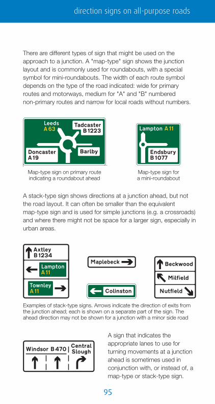
��
Map-type sign on primary route indicating a roundabout ahead
Map-type sign for a mini-roundabout
Examples of stack-type signs. Arrows indicate the direction of exits from the junction ahead; each is shown on a separate part of the sign. The ahead direction may not be shown for a junction with a minor side road
There are different types of sign that might be used on theapproach to a junction. A "map-type" sign shows the junctionlayout and is commonly used for roundabouts, with a specialsymbol for mini-roundabouts. The width of each route symboldepends on the type of the road indicated: wide for primaryroutes and motorways, medium for "A" and "B" numberednon-primary routes and narrow for local roads without numbers.
A stack-type sign shows directions at a junction ahead, but notthe road layout. It can often be smaller than the equivalentmap-type sign and is used for simple junctions (e.g. a crossroads)and where there might not be space for a larger sign, especially inurban areas.
A sign that indicates theappropriate lanes to use forturning movements at a junctionahead is sometimes used inconjunction with, or instead of, amap-type or stack-type sign.
direction signs on all-purpose roads
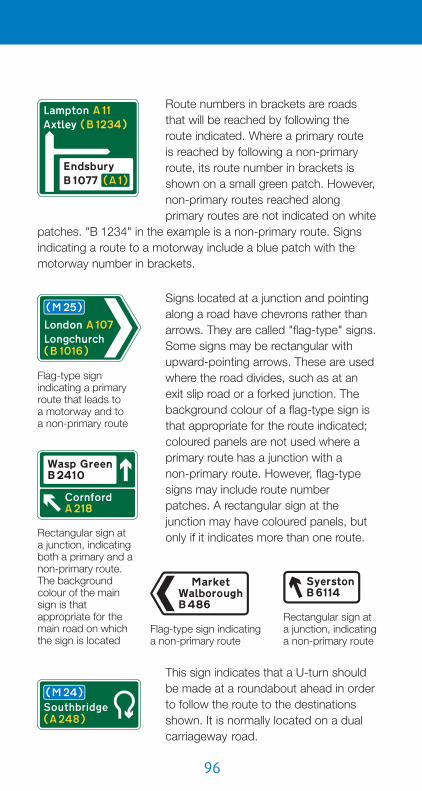
��
Flag-type sign indicating a non-primary route
Rectangular sign at a junction, indicating a non-primary route
Route numbers in brackets are roadsthat will be reached by following theroute indicated. Where a primary routeis reached by following a non-primaryroute, its route number in brackets isshown on a small green patch. However,non-primary routes reached alongprimary routes are not indicated on white
patches. "B 1234" in the example is a non-primary route. Signsindicating a route to a motorway include a blue patch with themotorway number in brackets.
Signs located at a junction and pointingalong a road have chevrons rather thanarrows. They are called "flag-type" signs.Some signs may be rectangular withupward-pointing arrows. These are usedwhere the road divides, such as at anexit slip road or a forked junction. Thebackground colour of a flag-type sign isthat appropriate for the route indicated;coloured panels are not used where aprimary route has a junction with anon-primary route. However, flag-typesigns may include route numberpatches. A rectangular sign at thejunction may have coloured panels, butonly if it indicates more than one route.Rectangular sign at
a junction, indicating both a primary and a non-primary route. The background colour of the main sign is that appropriate for the main road on which the sign is located
Flag-type sign indicating a primary route that leads toa motorway and to a non-primary route
This sign indicates that a U-turn shouldbe made at a roundabout ahead in orderto follow the route to the destinationsshown. It is normally located on a dualcarriageway road.

��
Route confirmatory sign Route confirmatory sign including a regional destination (The SOUTH WEST) and the distance to a motorway
Direction sign showing distances to destinations
Route confirmatory sign on anon-primary route leading to a primary route. "Lampton" is reached by turning onto the A 11 at a junction ahead
Route confirmatory sign: "Axtley" is on the current route; "Rickwell" is reached by turning onto the B 1555 at a junction ahead
Where a turningmovement isprohibited, signsmay show analternative route.
A sign may indicate the distance toa destination in miles. Fractions ofa mile may be shown for distancesless than 3 miles. Signs may beprovided after a junction listingdestinations and distances: theseare known as route confirmatorysigns.
direction signs on all-purpose roads
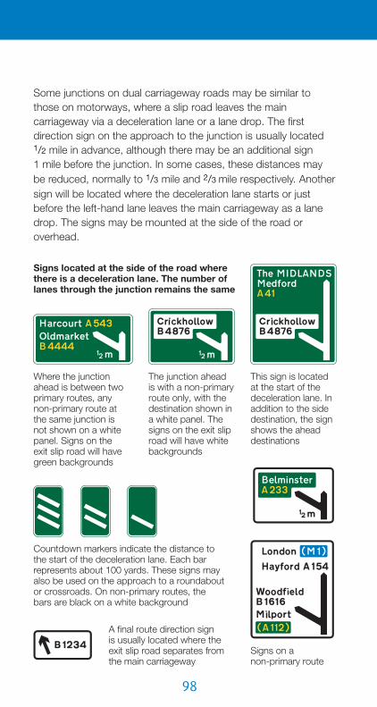
��
Countdown markers indicate the distance to the start of the deceleration lane. Each bar represents about 100 yards. These signs may also be used on the approach to a roundabout or crossroads. On non-primary routes, the bars are black on a white background
Signs located at the side of the road where there is a deceleration lane. The number of lanes through the junction remains the same
Where the junction ahead is between two primary routes, anynon-primary route atthe same junction isnot shown on a white panel. Signs on theexit slip road will have green backgrounds
The junction ahead is with a non-primary route only, with the destination shown in a white panel. The signs on the exit slip road will have white backgrounds
This sign is located at the start of the deceleration lane. In addition to the side destination, the sign shows the ahead destinations
Signs on anon-primary route
A final route direction signis usually located where the exit slip road separates from the main carriageway
Some junctions on dual carriageway roads may be similar tothose on motorways, where a slip road leaves the maincarriageway via a deceleration lane or a lane drop. The firstdirection sign on the approach to the junction is usually located1/2 mile in advance, although there may be an additional sign1 mile before the junction. In some cases, these distances maybe reduced, normally to 1/3 mile and 2/3 mile respectively. Anothersign will be located where the deceleration lane starts or justbefore the left-hand lane leaves the main carriageway as a lanedrop. The signs may be mounted at the side of the road oroverhead.

��
Overhead signs for junctions with deceleration lanes and slip roads, where the number of lanes through the junction remainsthe same
Non-primaryroute sign
Primary route sign
Signs for a junction where a lane leaves the main carriageway to become the exit slip road. Primary route signs have green backgrounds. Non-primary route signs have white backgrounds
Signs mounted at the side of the carriageway in advance of the junction
Signs mounted at the side of the carriageway just before the left-hand lane leaves the main carriageway
Overheadsigns
direction signs on all-purpose roads

100
Safari park Beach Museum (England)
Roman remains
Aviation museum
Tourist information
Castle Historic house
National Trust
English Heritage
Theme park Bird garden
Nature reserve
Farm parkCountry park
Signs for tourist destinationsTourist destinations may be shownon separate signs with brownbackgrounds, or on brown panelsincorporated into other directionsigns. See page 84 for touristdestination signs on motorways.
Symbols are often used to indicate the type of destination. Thesemay be shown on road maps. Once the full name of a tourist
destination and its symbol have been shownon a sign, subsequent signs may show onlythe associated symbol. Examples of symbolsare shown below.

101
FishingRace course Ski slopeTen-pin bowling
Cycle hire
Golf course
Motor sport
Football ground
Sports centre (England)
Cricket ground
ScotlandEngland Wales
This sign is used in advance of a junction, advising drivers of the route to be followed where it is not practicable to sign a tourist destination at the junction itself
Signs showing the distance ahead to a tourist attraction
Direction signs may indicate a route through an area of special interest
There are also symbols for sports and leisure facilities.
See pages 103 and 104 for symbols and brown signs used fortourist facilities such as camp sites, restaurants and hotels. Somesymbols are directional and face in the direction in which trafficturns at a junction. For ahead destinations, symbols generallyface left. Some tourist attractions may use a general symbol,depending on whether they are in England, Scotland or Wales.
direction signs on all-purpose roads

10�
Location of tourist information point or centre
Direction to a tourist information point or centre
Tourist information board(sign for pedestrians)
Direction to a parking place associated with a tourist attraction
"not 24 hrs" may be varied to "Fuel only 24 hrs" or omitted if the services are open 24 hours every day. The cup symbol indicates that light refreshments are available. The wheelchair symbol denotes facilitiesfor the disabled
Direction to services
Distance to services
On the approach to a junction, a signmay indicate a town or geographicalarea with several tourist attractions.
Services signsSee page 86 for blue-background signs indicating motorwayservice areas located on all-purpose roads. Services groupedtogether at a single location on primary and non-primary routesmay be signed where parking, toilets, fuel and refreshments areavailable at least between 8 am and 8 pm on every day exceptChristmas Day, Boxing Day and New Year’s Day. Signs onnon-primary routes have white backgrounds. Older signs onprimary routes have green backgrounds, but are being replacedby white-background signs.

10�
Alternative signs indicating the entrance to services. May be used to indicate the direction to services at a road junction
The services may have a geographical name. The "LPG" symbol means LPG fuel is available, the spoon and fork symbol denotes a restaurant and the bed symbol indicates overnight accommodation. The lorry symbol indicates that the services are for goods vehicles only. Where the symbol has a red bar, services are not available for goods vehicles
Signs on the approach to the junction
Signs located where traffic turns at the junction
Where individual facilities are available in a small town or villageoff the main route, signs at the junction indicate the direction inwhich they are located. If tourist facilities are available, the signshave a brown background and may include some of the symbolsshown on pages 100 and 101.
Brown signs may indicate establishments that provide restaurantfacilities, light refreshments or overnight accommodation.
direction signs on all-purpose roads

10�
Camping and caravan site: the tent or the caravan symbol may be omitted, depending on the facilities available. The name of the camp site may be shown
Youth hostel
Picnic area: may include a name
Distance to a parking place withtoilets, tourist information, picnic area, telephone and viewpoint. The symbols may be varied as appropriate
Licensed camping and caravan sites, youth hostels managed bythe Youth Hostels Association or Scottish Youth HostelsAssociation, picnic areas, viewpoints and parking places withtourist information may also be indicated by brown signs.
Parking signsDirection signs indicating parkingplaces, such as off-street car parks,have white backgrounds, even onprimary routes. Where the parkingdestination is incorporated into aprimary route sign with a greenbackground, it is shown on awhite panel.

10�
Where parking places in different directions are shown on a sign in advance of a junction, the "P" symbol may be shown at the top of the sign only
This map-type sign indicates the direction of routes to parking places from a double mini-roundabout ahead. The route to the right leads to a parking place for solo motor cycles only
Where a parking place is for a particular class of vehicle, this may be shown by the appropriate symbol. This sign indicates a lorry park that is reached by making a U-turn at a roundabout ahead
Direction and distance to a multi-storey car park
Direction to a parking place that is available on certain days only
Direction to a parking place showing the total number of spaces
Direction to a parking place that has been approved by the police under the Safer Parking Scheme
A variable message sign may indicate the availability of spacesat each parking place. Some signsmay show the number of vacant spaces; these are updated atregular intervals throughout the day
Sign showing the facilities available at a parking place ahead. The lorry symbol is omitted where there is no restriction on the class of vehicle
The signs may include various details about the parking places.
direction signs on all-purpose roads

10�
This sign is used in advance of a junction, advising drivers of goods vehicles of the route to be followed where it is not practicable to sign the route at the junction itself
Direction sign at a junction Direction signs on the approach to a junction
Signs may indicate the location ofparking places associated with"Park and Ride" schemes. Whereappropriate, the bus symbol ischanged to another form oftransport, e.g. tram, nationalrailway or London Underground.The sign may include the name ofthe Park and Ride site or the placethat it serves. It may also includethe times of operation. Otherdirection signs may incorporatethe blue "Park and Ride" panel.
Signs for drivers of goods vehiclesRoutes recommended for goodsvehicles have black signs with awhite lorry symbol. Other directionsigns may incorporate black lorryroute panels. The most suitableroute for lorries to a particulardestination may be different fromthat for other vehicles. The lorrysymbol faces in the direction in
which vehicles turn at a junction. For ahead destinations, thesymbol generally faces left. Where route numbers for motorwaysand primary routes are shown, these are placed on blue andgreen patches respectively.

10�
Symbols that may be used to indicate a diversion route
Signs incorporating a diversion route symbol that is shown alongside the road number of the route that drivers should follow
Separate signs indicating a diversion route (may be permanently displayed)
Signs for traffic diversionsWhere, in an emergency, it is necessaryto close a section of motorway or othermain road to traffic, a temporary signmay advise drivers to follow a diversionroute. To help drivers navigate the route,black symbols on yellow patches maybe permanently displayed on existing
direction signs, including motorway signs. On all-purpose roads,the symbols may be used on separate signs with yellowbackgrounds.
Temporary diversion signs may be required when a road is closedfor reasons other than an emergency, e.g. to carry out works.
The symbol on this sign may be replaced by route numbers
direction signs on all-purpose roads

10�
A road through a by-passed town or village leads back to the main route
The name of the junction ahead may be shown at the top of the sign
Signs may incorporate prohibitory roundels and indicate alternative routes
Signs may incorporate hazard warning triangles. In this example there is an opening bridge on the road to the right
Staggered crossroads on a dual carriageway road: the white panel with the red border indicates a Ministry of Defence establishment
Direction signs at the junction may incorporate warning triangles or prohibitory roundels. A distance plate indicates that the hazard or restriction is not encounteredimmediately
Examples of other direction signs

10�
Ministry of Defence establishments may also be shown on separate signs with red borders, arrows and chevrons. The background colour is always white, even on a primary route
This sign shows a local road with three junctions ahead in close proximity. The "H" symbol on a red patch indicates a hospital with "A & E" facilities (if there is no "A & E", a blue patch is used). The "WC" and wheelchair symbols indicate toilets with facilities for disabled people
Local destinations, including a railway station and recycling centre, reached along a primary route
This sign shows both primary andlocal destinations that are reachedalong a primary route at a junction ahead. At some junctions, a separate sign might be used to indicate local destinations where this would avoid putting too much information on a single sign. In this example, the sign indicates that the primary route is a ring road
These signs are used where there are more destinations than can be accommodated on the signs at a junction. They are located in advance of the first sign for the junction and advise drivers of the routes to be followed for particular destinations
Signs may indicate an alternative route
direction signs on all-purpose roads
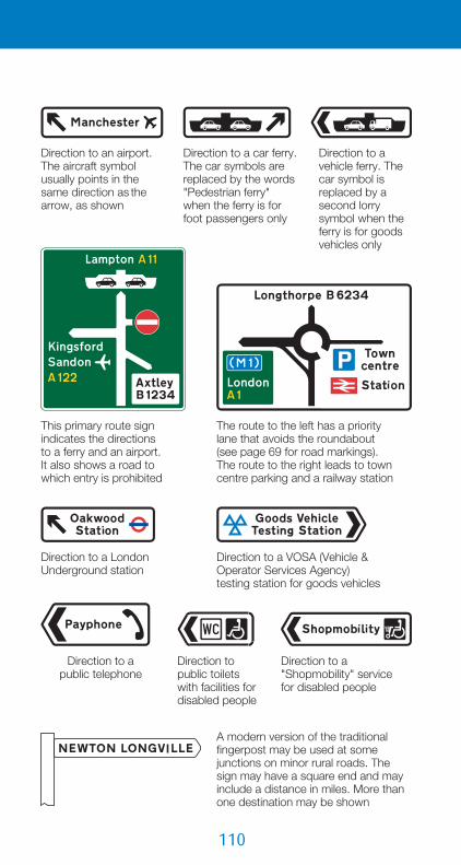
110
Direction to an airport. The aircraft symbol usually points in the same direction as the arrow, as shown
Direction to a car ferry. The car symbols are replaced by the words "Pedestrian ferry"when the ferry is for foot passengers only
Direction to a vehicle ferry. The car symbol is replaced by a second lorry symbol when the ferry is for goods vehicles only
The route to the left has a priority lane that avoids the roundabout (see page 69 for road markings). The route to the right leads to town centre parking and a railway station
This primary route sign indicates the directions to a ferry and an airport. It also shows a road to which entry is prohibited
Direction to a London Underground station
Direction to a VOSA (Vehicle & Operator Services Agency) testing station for goods vehicles
Direction to a public telephone
Direction to public toilets with facilities for disabled people
Direction to a "Shopmobility" service for disabled people
A modern version of the traditional fingerpost may be used at some junctions on minor rural roads. The sign may have a square end and may include a distance in miles. More than one destination may be shown

111
Signs with a red background areused to indicate the route for emergency vehicles to a temporary incident control point
Signs with a light green background and yellow border are used to indicate the route for emergency vehicles to a permanent incident control point
Signs indicating the direction to a new housing development may be left in place for up to six months after completion of the development
Signs that indicate the appropriate traffic lanes for turning movementsat a junction ahead may be used alone or in addition to map-type orstack-type advance direction signs. Signs on primary routes have green backgrounds, and signs on non-primary routes have white backgrounds
These signs show how traffic lanes on a slip road join the main carriageway of a dual carriageway road at junctions. Signs on primary routes have green backgrounds, and signs on non-primary route have white backgrounds
The slip road joins the main carriageway as a lane gain to increase the number oflanes from two to three.A distance panel may be added
The right-hand lane of the slip road joins the main carriageway as a merge with an acceleration lane. This is followed by the left-hand lane, which joins the main carriageway as a lane gain. Chevron road markings normally separate the two lanes on the slip road. The distance may be omitted
Sign for drivers on slip road
Sign for drivers on main carriageway
Sign for drivers on slip road
Sign for drivers on main carriageway
direction signs on all-purpose roads

11�
Primary route direction sign, in advance of a junction, indicating a route for cyclists
Non-primary route direction sign, in advance of a junction, indicating a route for cyclists
Sign showing the direction and distances (in miles) to destinations along a named cycle route forming part of the National Cycle Network
Number of a national cycle route
Number of a regional cycle route
Direction signs for cyclists andpedestriansDirection signs specifically for cyclists have a blue backgroundand include a white pedal cycle symbol. Most are free-standingsigns, but some primary and non-primary route direction signsmay incorporate a blue panel indicating a route for cyclists that isdifferent from that for other traffic. The cycle symbol may also beused on pedestrian signs where cyclists and pedestrians sharethe route (see page 113).
Where the route indicated forms part of the National CycleNetwork, the number of that route is shown on the signs in whitenumerals on a red patch. Links within the network may bedesignated as Regional Cycle Routes: signs indicating these havewhite route numbers on blue patches. Some local authorities mayhave their own numbered cycle routes using different colouredpatches. Where a cycle route leads to a national or regional route,the number of the route to which it leads may be shown inbrackets. Signs may also include the name of the route.

11�
Pedestrian and cycle route to a railway station
A public footpath may be indicated by a yellow waymarker. A blue arrow is used for public bridleways. The background may be of a different colour
Sign indicating two different cycle routes leading from a junction ahead
Map-type signs may indicate the route through a junction. In this example, the sign shows the route across an entry slip road. A sign may be used to direct cyclists to a signal-controlled crossing
Direction of a national cycle route
Signs indicating the direction to a parking place for pedal cycles
This sign informs you that you are following a national cycle route with the number shown
Direction signs for pedestriansgenerally have a blue backgroundwith white lettering and includethe walking figure symbol. In towncentres, especially pedestrianisedareas, other colours may be usedand the symbol may be omitted;these signs may also use differentstyles of lettering. Pedestrianroutes to tourist attractions mayhave brown backgrounds andthose for public footpaths greenbackgrounds. Signs may includedistances in yards or miles.
direction signs for cyclists and pedestrians

11�
These signs indicate the loss of the right-hand lane on a dual carriageway road or one-way street. The signs may be reversed to indicate the loss of the left-hand lane. The number of ahead lanes is varied as appropriate. The signs are often used at the end of a climbing lane and may include a distance (as shown for the motorway sign)
Non-primaryrouteMotorway
Primaryroute
Distance to the beginning of a dual carriageway road ahead
A section of dual carriageway road begins directly ahead
A short length of dual carriageway road begins directly ahead
No through road for vehicular traffic No through road
for vehicular traffic in the direction indicated from junction ahead
Passing place on a narrow road
This sign may be varied to indicate that a road is not suitable for a particular type of vehicle
"No through road" sign incorporated in a street nameplate
Narrow road ahead with passing places at intervals
Information signs
Information about the road ahead

11�
Distance ahead to a parking place
Distance ahead to a parking place with an emergency telephone
Location of parking place (may include an arrow to indicate the entrance to a parking area)
Location of parking place with an emergency telephone (may include an arrow)
Distance ahead to a parking place for emergency use only
Location of parking place for emergency use only (may include an arrow)
Signs for lay-bys and parking areas
Boundary signsSigns indicating county, town or village boundaries may include acrest or logo, a message of welcome, a phrase about a localgeographical or historical feature, or the names of twin towns.They may be any shape or colour. The town and village signs mayalso include tourist attraction symbols and road safety messages.A speed limit sign may be placed in combination with a boundarysign at a village gateway (see page 76). Other signs may showthe name of a river, inland waterway, bridge or tunnel.
information signs

11�
Hospitals with accident and emergency departments, or minor injury units, are indicated by red signs. The words "not 24 hrs" are omitted when facilities are available at all times
Blue signs indicate hospitals without accident and emergency facilities
Stepped entrance to a subway
Ramped entrance to a subway
Ramped approach to a footbridge
Stepped approach to a footbridge
Direction to an emergency exit from a road tunnel
This sign advises pedestrians crossing the road that trafficis one-way in the direction shown
Hospital signs
The route to a hospital may be indicated on direction signs by the“H” symbol on a red or blue patch, denoting whether accidentand emergency facilities are available or not (see page 109).
Signs for pedestrians
Signs for vehicle checksTemporary signs are put out when vehicles are to be stopped foran excise licence check or vehicle inspection. These signs mayapply to specific types of vehicle such as goods vehicles orbuses, and they may indicate which lanes to use.

11�
The type of vehicle indicated may be varied to a bus, or lorry and bus together
Examples of temporary signs for vehicle checks
These temporary signs are put out by the police to warn of potential danger or an accident ahead and the need to proceed with caution
In an emergency, drivers may be diverted onto the hard shoulder and told when to rejoin the main carriageway
Area where, from time to time, police carry out checks on the speed of vehicles
Parking area reserved for police vehicles (the sign might say "Police vehicles only") or additionally, when varied to "Authorised vehicles only", vehicles such as those of the Highways Agency's Traffic Officers
Police signs
information signs

11�
The depth of water at a ford may be shown in both metric and imperial units, or in imperial units only
Where a road is physically closed part-way along its length to prevent its useby through traffic, this sign may be erected at the closure point. Vehicles should not be parked in a manner that would obstruct any gateway or opening that allows access for emergency vehicles
Signs for drivers leaving the public road
Signs for drivers joining the public road
Signs used where there are separate entry and exit points to and from a car park, private access road or private property
A temporary sign may be provided for up to three months following a permanent change to the road layout ahead. The sign may be varied to indicate the nature of the change, such as a new roundabout, or that the operation of traffic signals has been changed
These temporary signs are used when traffic surveys are taking place.Vehicles may be directed to stop at the census point
Signs for traffic surveys
Other information signs

11�
RED means STOP. Wait behind the stop line on the carriageway until GREEN shows
RED and AMBER also means STOP. Do not pass the stop line until GREEN shows
GREEN means go IF THE WAY IS CLEAR. Take extra care if you intend to turn left or right, and give way to pedestrians who are crossing
AMBER means STOP. You may go on only if the amber appears after you have crossed the stop line or are so close to it that to pull up might cause an accident
Although you may turn right on a full green signal, a right-turn GREEN ARROW showing at the same time indicates that turning right shouldbe easier. Always check that opposing traffic has stopped before proceeding. If the full green is replaced by an ahead or left-turn arrow,you must wait until the right-turn arrow shows before you turn right
Signals indicatinga right turn
Traffic signalsIn most cases, in addition to the primary signals at the stop line,there are duplicate signals, known as secondary signals, locatedon the opposite side of the junction. If the primary signal is notworking, you must obey the secondary signal as if it were theprimary signal.
traffic signals

1�0
Signs may be placed with signals to qualify the meaning of the full green signal where movements through a junction are restricted
If movement is allowed in one direction only, the full green signal is normally replaced by a green arrow. This may be supplemented by a sign to reinforce the message
If a green arrow is shown with a red signal and the way is clear, you may go, but only in the direction shown by the arrow
Additional white light signals may be provided for tram drivers (see page 31)
In addition to level crossings (see page 27), these signals may be used at other locations, such as lifting bridges, airfields or fire stations. When the RED lights are flashing you must stop. AMBER has the same meaning as at normal traffic signals
Light signals for the control of pedal cycles. RED, AMBER and GREEN have the same meaning as at normal traffic signals
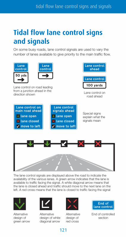
1�1
The lane control signals are displayed above the road to indicate the availability of the various lanes. A green arrow indicates that the lane is available to traffic facing the signal. A white diagonal arrow means thatthe lane is closed ahead and traffic should move to the next lane on the left. A red cross means that the lane is closed to traffic facing the signal
Lane control on road ahead
Lane control on road leading from a junction ahead in the direction shown
Special signs explain what the signals mean
Alternative design of green arrow
Alternative design of red cross
Alternative design of white diagonal arrow
End of controlled section
Tidal flow lane control signsand signalsOn some busy roads, lane control signals are used to vary thenumber of lanes available to give priority to the main traffic flow.
tidal flow lane control signs and signals

1��
Pedestrian, cycle andequestrian crossings
Zig-zag road markings
The zig-zag markings at crossings arethere to ensure that drivers andpedestrians can see each other clearly.As a driver, you must not park yourvehicle anywhere within these markings(before or after the crossing). Also, youmust not overtake a moving motorvehicle within the zig-zag area beforethe crossing, nor must you overtake avehicle that has stopped next to thecrossing either to obey signals orbecause pedestrians are using a Zebracrossing (see page 127). If you are in aqueue of vehicles that extends over acrossing, you should keep the crossingclear and look out for pedestrians whomight be in the road. As a pedestrian,for your own safety, do not cross theroad within the area marked by thezig-zags: keep to the crossing.Crossings for cyclists or horse ridersalso have zig-zag markings, and theabove rules apply to these also.

1��
Puffin crossingsThe Puffin is the latest type of pedestrian crossing controlled bysignals. It can detect the movement of pedestrians, so that it cangive them enough time to cross safely and keep any delay todrivers to a minimum. The pedestrian crossing time isautomatically varied according to the actual needs of thepedestrian and, if after the push button has been pressed thepedestrian decides to walk away, the call is automaticallycancelled and the pedestrian phase will not appear. This avoidsunnecessary delay to vehicular traffic and the irritation that mightbe caused by stopping vehicles when no pedestrians are waitingto cross.
For drivers approaching the crossing, the signals operate in thesame manner as those shown on page 119: there is no flashingamber signal as used for the older Pelican crossing. If you arerequired to stop, do not proceed until you have a green signaland have checked carefully that the way is clear.
The signals for pedestrians are locatedabove the push button and are knownas near-side signals. They can be seenwhen pedestrians are facing oncomingtraffic. If the green walking figure isshowing, you may cross the road, buttake care in doing so. If the redstanding figure is showing, press thepush button and wait for the greenfigure to show. Unlike in oldercrossings, the green figure does notflash before the signals change back tored. If the red figure comes on whenyou are about to cross, press the pushbutton and do not cross. Traffic will stillbe held on red for those pedestrianswho are already crossing the roadwhen the red figure comes on.
Near-side pedestrian signals with push button
pedestrian, cycle and equestrian crossings
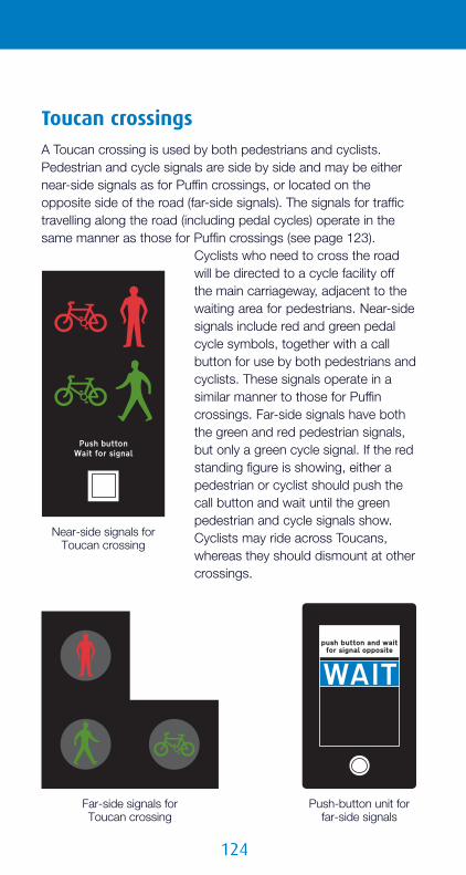
1��
Far-side signals for Toucan crossing
Push-button unit for far-side signals
Toucan crossingsA Toucan crossing is used by both pedestrians and cyclists.Pedestrian and cycle signals are side by side and may be eithernear-side signals as for Puffin crossings, or located on theopposite side of the road (far-side signals). The signals for traffictravelling along the road (including pedal cycles) operate in thesame manner as those for Puffin crossings (see page 123).
Cyclists who need to cross the roadwill be directed to a cycle facility offthe main carriageway, adjacent to thewaiting area for pedestrians. Near-sidesignals include red and green pedalcycle symbols, together with a callbutton for use by both pedestrians andcyclists. These signals operate in asimilar manner to those for Puffincrossings. Far-side signals have boththe green and red pedestrian signals,but only a green cycle signal. If the redstanding figure is showing, either apedestrian or cyclist should push thecall button and wait until the greenpedestrian and cycle signals show.Cyclists may ride across Toucans,whereas they should dismount at othercrossings.
Near-side signals for Toucan crossing

1��
Equestrian crossing
Pedestrian or Toucan crossing
Far-side signals for equestrian crossing
Push-button unit for far-side signals
Near-sidesignals forequestriancrossing
Equestrian crossingsThese may be provided for horse riderswhere, for example, a public bridlewaycrosses a road. In most cases, therewill be a parallel pedestrian or Toucancrossing. The signals for an equestriancrossing use the ridden horse symboland may be either near-side or far-side.Operation of the crossing is similar tothat of a Toucan crossing.
pedestrian, cycle and equestrian crossings

1��
Far-side signals for Pelican crossingPush-button unit
Pelican crossings
Signal-controlled junctionsRoad junctions controlled by traffic signals may include crossingfacilities for pedestrians, cyclists and equestrians. The signalsmay be either near-side or far-side. You should press the pushbutton and wait for the green pedestrian, cycle or horse signal toshow. Make sure that all traffic has stopped before crossing.Far-side signals for pedestrians operate differently from Pelicancrossings. The green signal is followed by a blank signal: do notstart to cross, but continue if you are already on the crossing.
The Pelican is the older type of pedestrian crossing with far-sidesignals. It will eventually be replaced by the Puffin crossingdescribed on page 123. At the end of the pedestrian phase, thegreen pedestrian signal flashes before the red standing figure
shows. At the same time, the redsignal for vehicular traffic changes toa flashing amber signal (replacing thered and amber phase shown onpage 119). The significance of thesesignals is that pedestrians should notstart to cross, but should continue ifalready on the crossing; drivers mayproceed, but only if the crossing iscompletely clear.
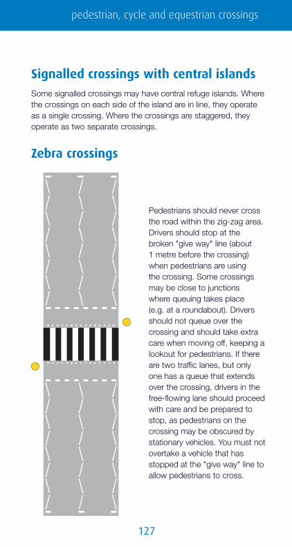
1��
Zebra crossings
Signalled crossings with central islandsSome signalled crossings may have central refuge islands. Wherethe crossings on each side of the island are in line, they operateas a single crossing. Where the crossings are staggered, theyoperate as two separate crossings.
Pedestrians should never crossthe road within the zig-zag area.Drivers should stop at thebroken "give way" line (about1 metre before the crossing)when pedestrians are usingthe crossing. Some crossingsmay be close to junctionswhere queuing takes place(e.g. at a roundabout). Driversshould not queue over thecrossing and should take extracare when moving off, keeping alookout for pedestrians. If thereare two traffic lanes, but onlyone has a queue that extendsover the crossing, drivers in thefree-flowing lane should proceedwith care and be prepared tostop, as pedestrians on thecrossing may be obscured bystationary vehicles. You must notovertake a vehicle that hasstopped at the "give way" line toallow pedestrians to cross.
pedestrian, cycle and equestrian crossings

1��
This sign, indicating road works or an obstruction in the carriageway ahead, may be used for any type of works, ranging from large construction schemes to minor maintenance
End of road works and any associated temporary restrictions, including speed limits
The "road works" sign may have a plate that indicates the distance to, the location of, or the nature of the works
Traffic cones may be used to mark the edge of the route for vehicular or pedestrian traffic through or past a temporary obstruction
At night or in poordaytime visibility,road danger lamps may additionally be used to indicate the limits of a temporary obstruction of the carriageway
Barriers are used to mark the boundaries of an area of the highway closed to vehicular and pedestrian traffic
Signs may provide information about the location of current or future road works where delays or road closures are expected. This gives drivers the opportunity to allow more time for future journeys, use alternative routes, or make other arrangements for the duration of the works
Signs for road works andtemporary situations

1��
On the approach to major road works, especially on motorways and dual carriageway roads, signs may indicate the nature and duration of the works
The traffic lanes that remain open are available to all traffic. The red bar indicates a lane that is closed ahead
Some traffic lanes that remain open may have restrictions. These signs show a narrow lane with a width restriction. Other restrictions may relate to vehicle height or weight
Traffic leaving at the next junction should use the near-side lane. This lane may also be used by traffic staying on the motorway Traffic lanes divide ahead. The lane
on the left leads to a junction and may also be used by traffic staying on the motorway. The right-hand lanes cross to the other carriageway. Areas closed to traffic are shown in red
Signs for lane closures and contra-flowsystems on motorways and dualcarriageway roads
signs for road works and temporary situations

1�0
Traffic lanes move across to the left, making use of the hard shoulder. Drivers are guided by temporary road markings or yellow road studs
Traffic lanes ahead are narrower than usual and move towards the left. Vehicles exceeding the width indicated mustuse the left-hand lane
Two adjacent traffic lanes separate. The right-hand lane moves to the right, but remains within the same carriageway
Two traffic lanes move to the right: one crosses over to the other carriageway. The advised speed where the lanes divert is 30 mph
These signs show the distance over which the reduced number of lanes continue through the road works. The signs are repeated at regular intervals, usually every ½ mile. In these examples, there are no lane restrictions such as a width limit. The vertical black line indicates that the left-hand lane is the hard shoulder. The white downward-pointing arrow indicates a contra-flow traffic lane separated by traffic cylinders (seepage 131). Where the contra-flow lane is separated by a physical barrier or a buffer lane (a lane closed to traffic), the white arrow is not shown

1�1
These repeater signs through the works are used where at least one lane has restricted use. The white downward-pointing arrow indicates a contra-flow traffic lane separated by traffic cylinders. Where the contra-flow lane is separated by a physical barrier or a buffer lane (a lane closed to traffic), the white arrow is not shown
Where a contra-flow system operates, traffic cylinders are used to separate opposing flows of traffic in adjacent lanes
Junctions may be accessible from within the road works area. The sign on the left shows an exit on the same carriageway. The signon the right shows an exit reached from a contra-flow lane on the other carriageway. The style of numerals used for the route number depends on whether the signs are on a motorway or an all-purpose road. The black patch shows the motorway junction number
These signs are located where the exit route leaves the main through route. The upper sign is used on motorways and the lower sign on all-purpose roads
The hard shoulder is used as an exit lane at a junction These signs show how lanes cross back
from the opposite carriageway at the end of a contra-flow system
signs for road works and temporary situations

1��
This sign indicates a lane change within the same carriageway. It is likely to be used near the end of the road works, prior to the carriageway being fully open
These signs indicate that use of the hard shoulder as a traffic lane has come to an end. Traffic is diverted onto the main carriageway. The sign on the right indicates that the carriageway ahead is fully open
Narrow traffic lanes revert to their normal width
Where delays are likely to occur at road works, the end sign may include a message of apology. The sign also means end ofall temporary restrictions, including speed limits
This sign may follow the "endof road works" sign to provide a telephone contact number for the traffic authority responsible for the road works
The slip road joins the main carriageway as a lane gain to increase the number of lanes from two to three.The permanent layout might include a traffic merge with an acceleration lane. A distance panel may be added at the bottom of each sign
Sign for drivers on slip road
Sign for drivers on main carriageway
Temporary signs indicating lane priorityat junctionsWhere slip roads leave and join at junctions within a road workssite, the permanent arrangement for lane drop, lane gain andtraffic merge may be temporarily changed. Signs may beprovided to show the temporary arrangements.
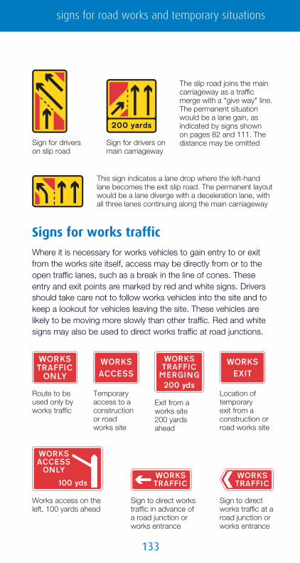
1��
This sign indicates a lane drop where the left-hand lane becomes the exit slip road. The permanent layout would be a lane diverge with a deceleration lane, with all three lanes continuing along the main carriageway
The slip road joins the main carriageway as a traffic merge with a "give way" line. The permanent situation would be a lane gain, as indicated by signs shownon pages 82 and 111. The distance may be omittedSign for drivers on
main carriagewaySign for drivers on slip road
Route to be used only by works traffic
Temporary access to a construction or road works site
Exit from a works site 200 yards ahead
Location of temporaryexit from a construction or road works site
Works access on the left, 100 yards ahead
Sign to direct works traffic in advance of a road junction or works entrance
Sign to direct works traffic at a road junction or works entrance
Signs for works trafficWhere it is necessary for works vehicles to gain entry to or exitfrom the works site itself, access may be directly from or to theopen traffic lanes, such as a break in the line of cones. Theseentry and exit points are marked by red and white signs. Driversshould take care not to follow works vehicles into the site and tokeep a lookout for vehicles leaving the site. These vehicles arelikely to be moving more slowly than other traffic. Red and whitesigns may also be used to direct works traffic at road junctions.
signs for road works and temporary situations

1��
Point beyond which vehicles should not proceed when temporary traffic signals show ared light
Traffic signals ahead where convoy working is in operation
Vehicles to be escorted in convoys through road works ahead
Reason for convoy working
When the green light shows at temporary traffic signals, vehicular traffic must follow the vehicle escorting the traffic through the road works
Sign on convoy vehicle ("NO OVERTAKING" may be omitted)
Advance warning may be given when delays are expected during overnight convoy working
Convoy workingAt some road works, other than on motorways, it may benecessary to slow traffic to a speed of 10 mph. To ensure thesafety of both road users and the workforce, traffic is takenthrough the works in convoy. At the start of the convoy section,traffic is controlled by either traffic signals or "STOP/GO" boards(see page 136). You must wait, where indicated, for the convoyvehicle that will escort you though the works. On singlecarriageway roads you must not overtake the convoy vehicle. Ondual carriageway roads you may overtake the convoy vehicle, if itis safe to do so, after you have passed through the works areaand signs have indicated that the speed limit has changed to ahigher limit. Where traffic signals are used at the start of theconvoy section, the red signal may show for a period longer thanyou would normally expect: do not proceed until the green lightshows. Convoy working may take place at any time during theday or night.

1��
Mobile road works and lane closuresSome road works can be carried out without the need for roadclosures or major traffic management schemes. The area of workis protected by a large stationary or slow-moving vehicle with asign mounted on the back.
On single carriageway urban roads with a speedlimit of 30 mph or less, the works will always beon the near side in the direction of travel. A "keepright" sign will be mounted on the back of theworks vehicle or the vehicle protecting the works.
There may also be a "keep left" sign on the front of the vehicle tobe viewed by traffic travelling in the opposite direction. Additionalstatic "road works ahead" signs may be placed at the side of theroad and may include a distance plate such as "For 1 mile" or"Grass cutting for 1 mile". There may also be "road narrows onthe left" signs (see page 11). The vehicle will usually have flashinglamps on its roof. The type of work likely to be carried outincludes grass cutting, weed spraying and gully emptying. Onsome busy roads, traffic may also be controlled by "STOP/GO"boards (see page 136).
On single carriageway roads with a speedlimit of 40 mph or more, the "keep right"sign on the back of the works vehicle orthe vehicle protecting the works includesflashing amber lamps. These lamps flash inpairs from top to bottom.
On motorways and dual carriageway roads,mobile lane closures may be introduced oneither the left-hand or right-hand side of thecarriageway. More than one vehicle will beused to protect the lane closure. All signswill have flashing amber lamps. A lightarrow may supplement the white-on-blue"keep right" or "keep left" arrow, and flashalternately with the amber lamps at the top.
signs for road works and temporary situations

1��
On the approach to mobile works on amotorway or dual carriageway road,vehicles with signs indicating the lanes thatare closed will be on the hard shoulder orat the side of the carriageway. The type ofwork undertaken includes line painting,minor repairs and setting out static roadworks signs.
Mobile carriageway closures may be used to convoy traffic whenit is necessary to hold traffic back while cones and signs aremoved to change a temporary contra-flow system, or perhaps to
remove an overhead cable. All lanes on thecarriageway will be closed, but traffic willmove slowly forward, over a distance ofseveral miles, on the approach to the areawhere the work is being undertaken. By thetime the convoy reaches this area, theworks should have been completed, trafficwill be allowed to increase its speed andtraffic lanes will be opened. The convoyvehicles will have a large red cross and redlamps flashing in vertical pairs.
Temporary traffic controlAt some road works sites on singlecarriageway roads where two-way trafficflow is not possible, it is necessary toalternate the direction of flow by trafficcontrol. This is known as shuttle working.For short lengths, this may be achieved bymanually-operated "STOP/GO" boards ateach end. At other sites, portable trafficsignals will be used. They operate in thesame way as permanent traffic signals (seepage 119). Normally, a stop line is notmarked on the road. A sign is used insteadto indicate where you must stop when thered signal shows.

1��
Details of a new road scheme under construction
Information about street works, with an emergency telephone number (sign for pedestrians)
Maximum speed advised, in miles per hour, on a road that has loose chippings
Maximum speed advised, in miles per hour, through road works
Temporary sudden change in level of carriageway
Temporary signals control a junction. "3-way" may be varied to "4-way"
Signs for an uncontrolled junction on a road with shuttle working. The sign on the right is for traffic on the side road
Sharp deviation of route to the left (right if chevrons reversed) at road works or other temporary obstruction
Temporary signals may be used to control a road junction. In thiscase, the red signal is likely to stay on longer than for normalshuttle working, as traffic on each leg of the junction will passthrough the road works separately. There may be a junction withina length of road subject to shuttle working that is not controlledby signals. Signs will warn drivers of this.
Miscellaneous temporary signs
signs for road works and temporary situations

1��
Where a mandatory speed limit is imposed at a road works site, advance warning may be given, especiallyon motorways and high-speed dual carriageway roads. However, this sign is less likely to be used in the future: the first speed limit sign will be located at the pointwhere the speed limit commences
In the event of a breakdown within a road works site, await rescue by free recovery service
Instructions to drivers of wide loads on action to be taken before reaching road works ahead (instructions may vary)
Location of telephone to be used by drivers of wide loads to seek assistance
The end of a temporary mandatory speed limit is indicated by the "end of road works" sign (see pages 128 and 132). However, the message may be reinforced by a sign indicating the permanent speed limit beyond the road works. This may be combined with the "end of road works" sign. Where the permanent limit after the works is different from that in advance of the works, a speed limit sign is always used. The national speed limit sign shown in the example is varied to the appropriate limit
Additional traffic lane available ahead as part of a temporary traffic management scheme
Sharp bends ahead where traffic is diverted onto a temporary road for a short distance: the number of traffic lanes remains the same
This sign is used on a single carriageway road with more than two lanes, to indicate that a lane in the centre of the road is temporarily closed

1��
Temporary sign used at road works to indicate the direction in which pedestrians should look for approaching traffic
Temporary sign used at road works to instruct cycliststo dismount anduse the adjacent footway
Temporary route for pedestrians
Vehicular traffic must not proceed beyond the sign when it is displayed for a short period during works on or near a road(hand-held sign)
Temporary hazard: vehicular traffic should proceed slowly
Vehicular traffic should proceed slowly, owing to workforce in the road ahead
Zebra or signalled crossing facility temporarily out of use (sign for pedestrians, cyclists or equestrians)
Variable message sign ahead not in use or being tested Traffic signals
not in use
Temporary absence of road markings for the distance shown
Sign on a vehicle being used in connection with highway maintenance works (flashing amber lamps are normally mounted on the roof of the vehicle)
Hard shoulder temporarily closed for the distance shown
signs for road works and temporary situations
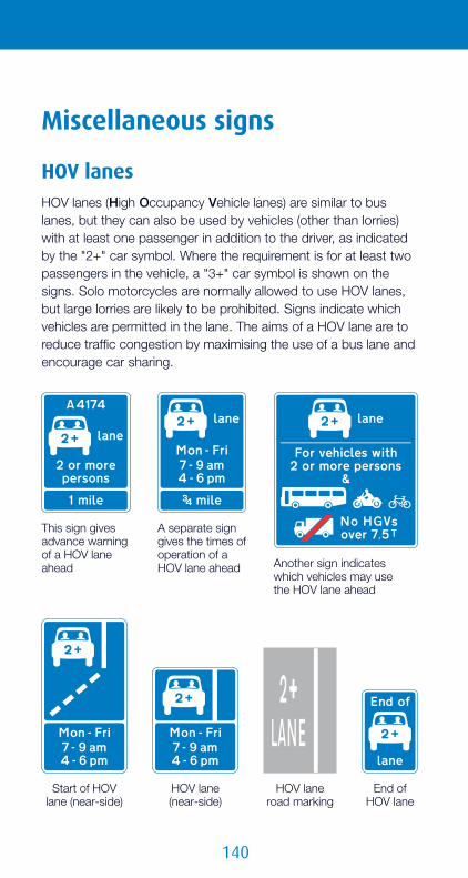
1�0
HOV laneroad marking
Another sign indicates which vehicles may use the HOV lane ahead
This sign gives advance warning of a HOV lane ahead
A separate sign gives the times of operation of a HOV lane ahead
End of HOV lane
Start of HOV lane (near-side)
HOV lane (near-side)
Miscellaneous signs
HOV lanesHOV lanes (High Occupancy Vehicle lanes) are similar to buslanes, but they can also be used by vehicles (other than lorries)with at least one passenger in addition to the driver, as indicatedby the "2+" car symbol. Where the requirement is for at least twopassengers in the vehicle, a "3+" car symbol is shown on thesigns. Solo motorcycles are normally allowed to use HOV lanes,but large lorries are likely to be prohibited. Signs indicate whichvehicles are permitted in the lane. The aims of a HOV lane are toreduce traffic congestion by maximising the use of a bus lane andencourage car sharing.

1�1
Off-side, with-flow bus-only lane ahead (the bus symbol facing right indicates that the lane leads to a right turn at a junction ahead)
Near-side, with-flow bus lane ahead that can also be used by solo motorcycles, pedal cycles and taxis
Near-side, with-flow bus lane ahead that can also be used by lorries, pedal cycles and taxis
Off-side, with-flow bus-only lane leading to a right turn at a junction ahead
Near-side, with-flow bus lane that can also be used by solo motorcycles, pedal cycles and taxis
Near-side, with-flow bus lane that can also be used by lorries, pedal cycles and taxis
HOV lanes (also known as car-sharing lanes) are to be introducedon some motorways. These could be on the right-hand side ofthe carriageway, where their use by buses might be prohibited.The HOV lane signs are likely to be mounted above thecarriageway to indicate which types of vehicle may use, or areprohibited from using, particular traffic lanes.
Bus lanesSigns and road markings for bus lanes are shown on pages 32and 33. However, in recent years different types of bus lane havebeen introduced. These may be centre or right-hand lanes on theapproaches to junctions, or may be lanes that can be used byother vehicles, such as solo motorcycles. Some examples areshown below. These signs may include a lower panel showing thetimes of operation.
miscellaneous signs

1��
Road chargingRoad charging was first introduced in central London and within a small area in Durham. The white on red "C" symbol is used on signs in both schemes and will, in future, be used to indicate road-charging schemes that might be introduced elsewhere. The symbol is not currently used for toll roads and tolled crossings, such as the M 6 Toll motorway.
This example shows a typical zone entry sign.The charging period is shown in the lowerpanel. The name of the traffic authority maybe shown at the top of the sign. The sign isusually supplemented by a "C" symbol roadmarking. Direction signs may incorporate the"C" symbol to indicate routes that lead intothe charging zone. Details of the actualcharges and the method of payment areavailable from the appropriate traffic authority.
Rising bollardsIn some town and city centres, certain streets may be closed forpart of the day, either to all traffic (e.g. pedestrian zones) or tothrough traffic, with access permitted, for example, to publictransport. Enforcement of these restrictions may be by the use of
automatic bollards that rise from the groundto provide a physical closure. Where suchbollards are in use, warning signs are normallyprovided. Where certain vehicles are allowedentry, red and green signals control theoperation of the bollards. Only one vehicleshould pass at any one time and mayproceed only if the green signal is showing.Some vehicles, e.g. buses, have devices that
can be recognised by detectors controlling the operation of thebollards. If you are not driving an authorised vehicle, do not followthe vehicle in front, as you may risk personal injury and damageto your own vehicle. Where pedal cycles are exempt, a separateroute avoiding the bollards is normally provided.

1��
Rising bollards might also be used at the exit to a road-chargingarea, such as in Durham (see page 142). These operate whenpayment has been made (similar to the exit from some car parks).
Driver location signsThese have been introduced at regular intervalsalong many motorways and some other roads sothat, in the event of a vehicle breakdown or otheremergency, the exact location can be identifiedquickly. They show the motorway or road number,the carriageway identifier and a distancereference.
Variable signsSome signs are designed toprovide information aboutvarying traffic conditions, suchas delays or diversions ahead,or to warn of specific hazards,such as animals or debris inthe road. These are called"variable message signs" and
may be free-standing with an electronic display, such as the signsthat have been erected above motorway hard shoulders. Somedirection signs contain variable elements. They might show, forexample, alternative routes, or the availability of spaces in carparks.
Signs activated by moving vehicles are provided as a road safetymeasure. They can give a reminder of the speed limit, or warningof a hazard such as a bend or crossroads. They are activatedwhen a vehicle is travelling above a certain speed and the driverneeds to slow down.
Variable signs are also used for traffic control, such as ActiveTraffic Management described on pages 91 to 93.
miscellaneous signs

1��
AcknowledgementsPhotographs of the traffic signs on pages 4–8 (except p8 bottom) were taken by Simon Lusty of the Driving Standards Agency, with assistance from Graham Stanton, who kindly allowed the use of his “Roadside Heritage Collection” of historic signs.
Printed in the United Kingdom for TSO N5531969 c300 07/07.
Published by TSO (The Stationery Office), part of Williams Lea, and available from:
Onlinewww.tsoshop.co.uk
Mail, Telephone, Fax & E-mailTSOPO Box 29, Norwich, NR3 1GNTelephone orders/General enquiries: 0333 202 5070Fax orders: 0333 202 5080E-mail: [email protected] 0333 202 5077
TSO@Blackwell and other Accredited Agents
9780115528552 010 KYTS COVER v2_0.indd 4-6 24/08/2015 12:15
Know Your
TRAFFICSIGNSOfficial Edition
Know Your TRAFFIC SIGNS
How well do you know your traffic signs?Traffic signs play a vital role in directing, informing and controlling road users’ behaviour in an effort to make the roads as safe as possible for everyone. A knowledge of traffic signs is therefore essential, not just for new drivers or riders needing to pass their theory test, but for all road users, including experienced professional drivers.
This book is a fully updated edition of the highly successful Know Your Traffic Signs first published by HMSO in 1975. It contains information about the most important traffic signs, including many introduced since the 1995 edition. The aim is to illustrate and explain the vast majority of traffic signs the road user is likely to encounter.
9 780115 528552
ISBN 978-0-11-552855-2
All road users
Know Your Traffic Signs - for life, not just for learners
www.tso.co.uk
£4.99
DfT
9780115528552 010 KYTS COVER v2_0.indd 1-3 24/08/2015 12:15