koen beerten, roland dreesen, jos janssen and ... - pnc.be
TRANSCRIPT

12The Campine Plateau
Koen Beerten, Roland Dreesen, Jos Janssen and Dany Van Uytven
AbstractOnce occupied by shallow andwide braided channels of theMeuse and Rhine rivers around theEarly toMiddle Pleistocene transition, transporting and depositing debris from southern origin,the Campine Plateau became a positive relief as the combined result of uplift, the protective roleof the sedimentary cover, and presumably also base level fluctuations. The escarpmentsbordering the Campine Plateau are tectonic or erosional in origin, showing characteristics ofboth a fault footwall in a graben system, a fluvial terrace, and a pediment. The intensivepost-depositional evolution is attested by numerous traces of chemical and physical weatheringduring (warm) interglacials and glacials respectively. The unique interplay between tectonics,climate, and geomorphological processes led to the preservation of economically valuablenatural resources, such as gravel, construction sand, and glass sand. Conversely, theirextraction opened new windows onto the geological and geomorphological evolution of theCampine Plateau adding to the geoheritage potential of the first Belgian national park, theNational Park Hoge Kempen. In this chapter, the origin and evolution of this particularlandscape is explained and illustrated by several remarkable geomorphological highlights.
KeywordsCampine plateau � Meuse terraces � Late Glacial and Holocene dunes � Tectonic controlon fluvial evolution � Polygonal soils � Natural resources � Coal mining
12.1 Introduction
The Campine Plateau is an extraordinary morphologicalfeature in northeastern Belgium, extending into the southernpart of the Netherlands (Fig. 12.1a). It runs from the south-east to the northwest, from an altitude of ca. 100 m a.s.l.
(TAW: Tweede Algemene Waterpassing) in the south, to ca.30 m near the Belgian-Dutch border in the north (Fig. 12.1b). The polygonal shape of this lowland plateau has attracteda lot of attention from geoscientists during the last 100 years,all the more since it is covered by a thick sheet of coarsefluvial deposits from the Rhine and Meuse (Paulissen 1973,1983). As these rivers’ current channels are located several totens of km further to the east, at a much lower altitude, theCampine Plateau witnesses a unique episode in the Quater-nary evolution of the region. The interplay of fault activity,uplift, weathering, fluvial incision, regressive erosion, sub-strate characteristics, and aeolian processes created the cur-rent shape of the plateau. The plateau can be considered aclassic case of relief inversion. The resulting steep borderingslopes are in strong contrast with the otherwise flat landscapeof the European sand belt.
K. Beerten (&)Engineered and Geosystems Analysis, Belgian Nuclear ResearchCentre SCK•CEN, Boeretang 200, 2400 Mol, Belgiume-mail: [email protected]
R. DreesenGeological Survey of Belgium, Royal Belgian Institute of NaturalSciences, Jennerstraat 13, 1000 Brussels, Belgiume-mail: [email protected]
J. Janssen � D. Van UytvenWerkgroep Geologie, LIKONA (Limburgse Koepel VoorNatuurstudie), Provinciaal Natuurcentrum, Craenevenne 86,3600 Genk, Belgium
© Springer International Publishing AG 2018A. Demoulin (ed.), Landscapes and Landforms of Belgium and Luxembourg,World Geomorphological Landscapes, DOI 10.1007/978-3-319-58239-9_12
193
The availability of erodible sand in the surrounding areaspromoted the development of aeolian sand sheets and largeinland dune areas (Fig. 12.1c) during the (Late) Weichselianwhen vegetation cover was sparse and the water table low.Furthermore, the poor sandy and stony soils and the deepgroundwater table have made the plateau area unattractivefor human occupation. Nevertheless, early agriculturalactivities and Mesolithic settlements seem to have existedclose to wetlands (Vermeersch et al. 1974). The collection ofheather sods for fertilizing soils (leading to the formation ofplaggen soils), a widespread practice in the region, causedsevere landscape instability from the fifteenth to the nine-teenth century, as a result of which drift sand landscapesdeveloped. Massive pine plantation during the late nine-teenth century and first half of the twentieth century led tostabilization of the landscape and destruction of heathland,serving notably the coal mining industry in the Liège andCampine coal fields.
The establishment of pine plantations was a direct resultof the need for wood in the galleries of underground coalmines in the nearby Liège area. Later, large amounts of pinewood were used in the Campine Plateau itself, where thegeological Campine Basin hosts many coal seams at severalhundreds of meters depth. The sandy and dry nature of thesoils that developed on Quaternary fluvial and aeoliandeposits provided an excellent habitat for pine trees. Simi-larly, gravel and, especially, sand extraction became
widespread economic activities in the plateau region (Gul-lentops and Wouters 1996). Miocene and Pliocene quartzsand, coarse Rhine sand and loamy Meuse gravels are dug inhuge extraction pits, the extent and depth of which can easilybe detected on uncorrected digital terrain models, just as thecoal spoil heaps. The deep groundwater table, as a result ofuplift and river incision, enables dry extraction of some ofthese mineral resources, in contrast to the much more diffi-cult wet extraction of, e.g., more valuable Meuse gravels inthe present-day floodplain.
This chapter provides a state-of-the-art overview on theorigin and development of the Campine Plateau, against abackground of climate change, tectonic movements andhuman activities. The link between the current landscape andthe overall evolution of the region is highlighted, as well asthe geoheritage value of the landscape (see Chap. 24).
12.2 Geographical and Geological Setting
12.2.1 Location of the Campine Plateau
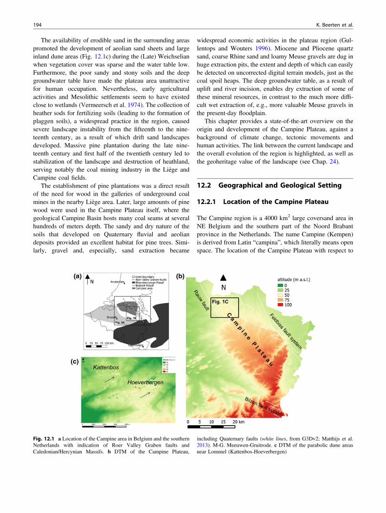
The Campine region is a 4000 km2 large coversand area inNE Belgium and the southern part of the Noord Brabantprovince in the Netherlands. The name Campine (Kempen)is derived from Latin “campina”, which literally means openspace. The location of the Campine Plateau with respect to
Fig. 12.1 a Location of the Campine area in Belgium and the southernNetherlands with indication of Roer Valley Graben faults andCaledonian/Hercynian Massifs. b DTM of the Campine Plateau,
including Quaternary faults (white lines, from G3Dv2; Matthijs et al.2013). M-G. Meeuwen-Gruitrode. c DTM of the parabolic dune areasnear Lommel (Kattenbos-Hoeverbergen)
194 K. Beerten et al.
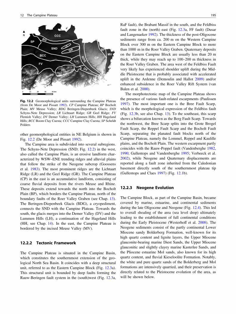
other geomorphological entities in NE Belgium is shown inFig. 12.2 (De Moor and Pissart 1992).
The Campine area is subdivided into several subregions.The Schyns-Nete Depression (SND; Fig. 12.2) in the west,also called the Campine Plain, is an erosive landform char-acterized by WSW–ENE trending ridges and alluvial plainsthat follow the strike of the Neogene subcrop (Goossenset al. 1983). The most prominent ridges are the LichtaartRidge (LR) and the Geel Ridge (GR). The Campine Plateau(CP) in the east is an accumulative landform, consisting ofcoarse fluvial deposits from the rivers Meuse and Rhine.These deposits extend towards the north into the BocholtPlain (BP), which borders the Campine Plateau, north of theboundary faults of the Roer Valley Graben (see Chap. 13).The Beringen-Diepenbeek Glacis (BDG), a cryopediment,connects the SND with the Campine Plateau. Towards thesouth, the glacis merges into the Demer Valley (DV) and theLummen Hills (LH), a continuation of the Hageland Hills(HH, see Chap. 14). In the east, the Campine Plateau isbordered by the incised Meuse Valley (MV).
12.2.2 Tectonic Framework
The Campine Plateau is situated in the Campine Basin,which constitutes the southernmost extension of the geo-logical North Sea Basin. It coincides with a deep structuralunit, referred to as the Eastern Campine Block (Fig. 12.3a).This structural unit is bounded by deep faults forming theRauw-Beringen fault system in the (south)west (Fig. 12.3a,
RaF fault), the Brabant Massif in the south, and the Feldbissfault zone in the (north) east (Fig. 12.3a, FF fault) (Dusarand Langenaeker 1992). The thickness of the post-Oligocenesediments range from ca. 200 m on the Western CampineBlock over 300 m on the Eastern Campine Block to morethan 1000 m in the Roer Valley Graben. Quaternary depositson the Eastern Campine Block are usually less than 20 mthick, while they may reach up to 100–200 m thickness inthe Roer Valley Graben. The area west of the Feldbiss Faultvery likely has experienced shoulder uplift during the Mid-dle Pleistocene that is probably associated with accelerateduplift in the Ardenne (Demoulin and Hallot 2009) and/orenhanced subsidence in the Roer Valley Rift System (vanBalen et al. 2000).
The morphotectonic map of the Campine Plateau showsthe presence of various fault-related escarpments (Paulissen1997). The most important one is the Bree Fault Scarp,which is the morphological expression of the Feldbiss fault(Fig. 12.3b, see also Chap. 13). To the southeast, this scarpshows a bifurcation known as the Berg Fault Scarp. Towardsthe northwest, the Bree Scarp splits into the Grote BrogelFault Scarp, the Reppel Fault Scarp and the Bocholt FaultScarp, separating the planated fault blocks north of theCampine Plateau, namely the Lommel, Reppel and Kaulilleplains, and the Bocholt Plain. The western escarpment partlycoincides with the Rauw-Poppel fault (Vandenberghe 1982,1990; Gullentops and Vandenberghe 1995; Verbeeck et al.2002), while Neogene and Quaternary displacements arereported along a fault zone inherited from the Caledonianbasement directly south of the southernmost plateau tip(Gullentops and Claes 1997) (Fig. 12.1b).
12.2.3 Neogene Evolution
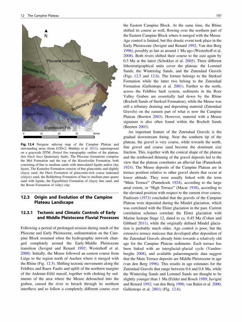
The Campine Block, as part of the Campine Basin, becamecovered by marine, estuarine, and continental sedimentsduring the late Oligocene and Neogene (Fig. 12.4). This ledto overall shoaling of the area (sea level drop) ultimatelyleading to the establishment of full continental conditionsduring the Early Pleistocene (Westerhoff et al. 2008). TheNeogene sediments consist of the partly continental LowerMiocene sandy Bolderberg Formation, well-known for itshigh quartz content and lignite layers, the Upper Mioceneglauconite-bearing marine Diest Sands, the Upper Mioceneglauconitic and slightly clayey marine Kasterlee Sands, andthe Pliocene estuarine Mol sands, also known for its highquartz content, and fluvial Kieseloolite Formation. Notably,the white and pure quartz sands of the Bolderberg and Molformations are intensively quarried, and their preservation isdirectly related to the Pleistocene evolution of the area, aswill be shown below.
Fig. 12.2 Geomorphological units surrounding the Campine Plateau(from De Moor and Pissart 1992). CP Campine Plateau; BP BocholtPlain; MV Meuse Valley; BDG Beringen-Diepenbeek Glacis; SNDSchyns-Nete Depression; LR Lichtaart Ridge; GR Geel Ridge; FVFlemish Valley; DV Demer Valley; LH Lummen Hills; HH HagelandHills; BCC Boom Clay Cuesta; CCC Campine Clay Cuesta; SP ScheldtPolders
12 The Campine Plateau 195
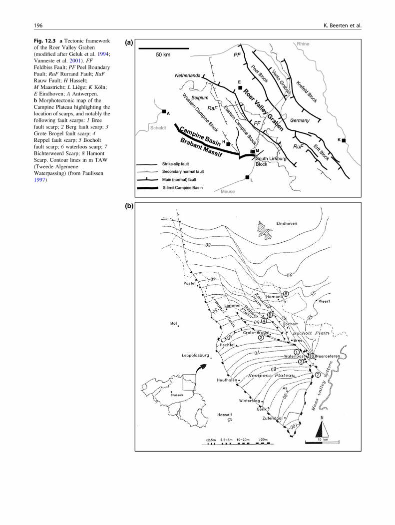
Fig. 12.3 a Tectonic frameworkof the Roer Valley Graben(modified after Geluk et al. 1994;Vanneste et al. 2001). FFFeldbiss Fault; PF Peel BoundaryFault; RuF Rurrand Fault; RaFRauw Fault; H Hasselt;M Maastricht; L Liège; K Köln;E Eindhoven; A Antwerpen.b Morphotectonic map of theCampine Plateau highlighting thelocation of scarps, and notably thefollowing fault scarps: 1 Breefault scarp; 2 Berg fault scarp; 3Grote Brogel fault scarp; 4Reppel fault scarp; 5 Bocholtfault scarp; 6 waterloos scarp; 7Bichterweerd Scarp; 8 HamontScarp. Contour lines in m TAW(Tweede AlgemeneWaterpassing) (from Paulissen1997)
196 K. Beerten et al.
12.3 Origin and Evolution of the CampinePlateau Landscape
12.3.1 Tectonic and Climatic Controls of Earlyand Middle Pleistocene Fluvial Processes
Following a period of prolonged erosion during much of thePliocene and Early Pleistocene, sedimentation on the Cam-pine Block resumed when the hydrographic network chan-ged completely around the Early-Middle Pleistocenetransition (Juvigné and Renard 1992; Westerhoff et al.2008). Initially, the Meuse followed an eastern course fromLiège to the region north of Aachen where it merged withthe Rhine (Fig. 12.5). Shifting tectonic movements along theFeldbiss and Rauw Faults and uplift of the northern marginsof the Ardenne-Eifel massif, together with choking by sed-iments of the area where the Meuse debouched into thegraben, caused the river to breach through its northerninterfluve and to follow a completely different course over
the Eastern Campine Block. At the same time, the Rhineshifted its course as well, flowing over the northern part ofthe Eastern Campine Block where it merged with the Meuse.Age control is limited, but this drastic event took place in theEarly Pleistocene (Juvigné and Renard 1992; Van den Berg1996), possibly as late as around 1 Ma ago (Westerhoff et al.2008). Both rivers shifted their course to the east again by0.5 Ma at the latest (Schokker et al. 2005). Three differentlithostratigraphical units cover the plateau: the LommelSands, the Winterslag Sands, and the Zutendaal Gravels(Figs. 12.5 and 12.6). The former belongs to the SterkselFormation while the latter two belong to the ZutendaalFormation (Gullentops et al. 2001). Further to the north,across the Feldbiss fault system, sediments in the RoerValley Graben are essentially laid down by the Rhine(Bocholt Sands of Sterksel Formation), while the Meuse wasstill a tributary draining and depositing material (ZutendaalGravels) on the eastern part of what is now the CampinePlateau (Beerten 2003). However, material with a Meusesignature is also often found within the Bocholt Sands(Beerten 2003).
An important feature of the Zutendaal Gravels is thegradual downstream fining. Near the southern tip of theplateau, the gravel is very coarse, while towards the north,fine gravel and coarse sand become the dominant sizefraction. This, together with the conical shape of the plateauand the northward thinning of the gravel deposits led to theview that the plateau constitutes an alluvial fan (Pannekoek1924). The Meuse deposits of the Campine Plateau are interrace position relative to other gravel sheets that occur atlower altitude. They were usually linked with the term“Main Terrace” (Pannekoek 1924), according to the largeareal extent, or “High Terrace” (Macar 1938), according tothe elevated position with respect to the current river course.Paulissen (1973) concluded that the gravels of the CampinePlateau were deposited during the Mindel glaciation, whichwas correlated with the Elster glaciation in the past. Currentcorrelation schemes correlate the Elster glaciation withMarine Isotope Stage 12, dated to ca. 0.45 Ma (Cohen andGibbard 2011), while the originally defined Mindel glacia-tion is probably much older. Age control is poor, but theextensive terrace staircase that developed after deposition ofthe Zutendaal Gravels already hints towards a relatively oldage for the Campine Plateau sediments. Each terrace hasbeen linked with an interglacial–glacial cycle (Vanden-berghe 2008), and available palaeomagnetic data suggestthat the Main Terrace deposits are Middle Pleistocene in age(van den Berg 1996). This results in age estimates for theZutendaal Gravels that range between 0.6 and 0.8 Ma, whilethe Winterslag Sands and Lommel Sands are thought to beslightly younger than 1 Ma (Felder and Bosch 1989; Juvignéand Renard 1992; van den Berg 1996; van Balen et al. 2000;Gullentops et al. 2001) (Fig. 12.6).
Fig. 12.4 Neogene subcrop map of the Campine Plateau andsurrounding areas (from G3Dv2; Matthijs et al. 2013), superimposedon a grayscale DTM. Dotted line topographic outline of the plateau;thin black lines Quaternary faults. The Pliocene formations comprisethe Mol Formation and the top of the Kieseloolite Formation, bothconsisting of fine to medium sands with intercalated lignite and/or claylayers. The Kasterlee Formation consists of fine glauconitic and slightlyclayey sand, the Diest Formation of glauconite-rich coarse indurated(clayey) sand, the Bolderberg Formation of fine to medium pure quartzsand with lignite, the Eigenbilzen Formation of clayey fine sand, andthe Boom Formation of (silty) clay
12 The Campine Plateau 197

12.3.2 The Aftermath: Posterior Development
12.3.2.1 Relief InversionThe development of fluvial sequences on the Campine Blockand in the Roer Valley Graben is clearly associated with thecreation of accommodation space, as a result of subsidence.Wide and shallow valleys occupied by braided river chan-nels developed during the Early to Middle Pleistocenetransition. The elevated position of these fluvial sequenceson top of the plateau, well above the current floodplain of theMeuse, thus needs to be interpreted as a classic case of reliefinversion. The erodibility of the coarse grained deposits,ranging from coarse gravel to gravelly sand, is lower thanthat of the fine sandy Neogene units on which they were laiddown. Regions that remained outside the sedimentationrealm of the Meuse-Rhine, would thus become preferentiallyeroded. The western edge of the Campine Plateau can be
explained in this way. Sedimentation by the Rhine-Meusesystem stopped near the western edge of the Eastern Cam-pine Block, delimited by the Rauw Fault and its southernextension (Fig. 12.3a). The topography of the area west ofthis fault system was subsequently lowered by regressiveerosion from rivers draining the Scheldt basin. This processwas accompanied by slope retreat and the development of apediment, the BDG (Figs. 12.1, 12.2 and 12.6). It resulted ina relief difference of several tens of meters between theplateau and the area west of it.
The effect of regressive erosion in the SND can clearly beobserved from the DTM (Fig. 12.1), where the headwatersof the Kleine and Grote Nete can be followed onto theplateau. Enhanced regressive erosion in the Nete basin isprobably triggered by erosional events around 450 ka in thesouthern North Sea basin when the English Channel wasopened as a result of a proglacial lake burst (Gupta et al.2007; Toucanne et al. 2009).
Several uplift records indicate that the southern part of theCampine Plateau experienced around 50 m of uplift since thelast 0.7 Ma (van Balen et al. 2000). Around this time, theMeuse was gradually shifting its course to the east again, andstarted developing the lower part of its extensive terracestaircase (Figs. 12.5 and 12.6). The southern tip of the plateaushows traces of palaeo-meanders that are preserved in thelandscape when they laterally carved and incised into olderMeuse deposits. An example is the Lanaken terrace (LanakenFormation), consisting of a relatively thin gravel sheet ca. 10–20 m below the Campine Plateau surface (Paulissen 1973).Subsequent downcutting-infilling cycles were responsible forthe development of the Caberg-Pietersem terrace (LanakenFormation) and Eisden-Lanklaar, Maasmechelen andGeistingen terraces (Lanklaar Formation) (Figs. 12.5, 12.6and 12.7). The vertical offset between the Campine PlateauMain Terrace and the Saalian Eisden-Lanklaar terrace rangesup to 50 m as a result of fluvial erosion.
The northeastern edge of the Campine Plateau is tectonicin origin. It is known as the Bree Fault Scarp, which is themorphological expression of the Feldbiss fault system(Vanneste et al. 2001; see also Chap. 13). The diffuse con-tinuation of the Meuse deposits north of the Bree escarpmentseverely complicates their correlation with Rhine deposits inthe Roer Valley Graben (Beerten 2003). Nevertheless, it islikely that the Feldbiss Fault caused a cumulative verticaldisplacement of ca. 25–40 m since deposition of theZutendaal Gravels (Beerten et al. 1999; Vanneste et al.2001).
12.3.2.2 Weathering, Soil Formation,and Periglacial Deformation
Several glacial–interglacial cycles occurred after depositionof the Rhine-Meuse sediments on top of the Campine Pla-teau, leaving sufficient time for post-depositional processes
Fig. 12.5 Lithostratigraphic map of the Meuse deposits downstreamof Maastricht (modified after Verstraelen 2000; Beerten 2005a, b,2006). Arrows indicate flow direction of the Rhine and Meuse at thetime of deposition of the different stratigraphical units. Numbersindicate the relative chronology of the various units (from oldest 1 toyoungest 4). The entire depositional history is thought to have takenplace in the timeframe between ca. 1 and 0.5 Ma (Schokker et al. 2005;Westerhoff et al. 2008). The Winterslag Sands and Zutendaal Gravelsare grouped into the Zutendaal Formation (informally referred to asMain Terrace deposits from the Meuse), while the Lommel and BocholtSands belong to the Sterksel Formation (Gullentops et al. 2001). TheSterksel Formation consists of Rhine deposits with uptake of materialfrom the river Meuse
198 K. Beerten et al.

such as weathering, soil development, and periglacialdeformation. At some places, the typical red-brown inter-glacial weathering soil (As Soil; e.g., Gullentops et al. 1993)
developed deeply into the gravel deposits (Fig. 12.8). Suf-ficient precipitation, a deep groundwater table, and theavailability of mobile iron are necessary boundary condi-tions for the development of this soil. Limonite and goethiteconcretions often give the gravel a cemented appearance,further contributing to its resistance to erosion. This soil isvery well developed in the eastern part of the CampinePlateau that more or less coincides with the ZutendaalGravel outcrop zone (Figs. 12.4 and 12.5). Interestingly, theAs Soil is not preserved in the western and northwestern partof the Campine Plateau, or it did not develop there. Severalfactors might account for this discrepancy. First, the avail-ability of iron could be larger in the Zutendaal Gravels thanin other fluvial units of the Campine Plateau, because of theinitial presence of now dissolved iron-rich limestones (he-matite oolitic ironstones) from Upper Devonian rocks in thesouth of the Namur syncline, and/or Jurassic minette-typeoolitic ironstones from the Lorraine area. Second, theZutendaal Gravels are more erosion-resistant than the moresandy Winterslag and Lommel Sands, such that the soil mayhave been eroded from these sandy units. Third,southeast-northwest tilting of the plateau resulted in deep
Fig. 12.6 Lithostratigraphic table of the units depicted in Figs. 12.5and 12.7 and the associated geomorphological, climatic and tectonicdevelopment of the area before, during, and after deposition of theMain Terrace deposits (created with TimeScaleCreator-PUBLIC-6.4-21Feb2015). GP refers to the direction of the palaeomagnetic field(black normal; white reversed). The Early to Middle Pleistocenetransition coincides with the Brunhes-Matuyama geomagnetic bound-ary (*0.78 Ma). ECB Eastern Campine Block (see Fig. 12.3a). Arrows
up refer to the onset of uplift in the region, arrows down to subsidence;phases of normal faulting are indicated by doubled oblique arrows. Assoil interglacial weathering soil in Zutendaal Gravels. According toGullentops et al. (2001), the Meuse deposits on top of the CampinePlateau are younger than the Rhine deposits. This opinion has recentlybeen questioned in the Quaternary subcommission of the NationalCommission for Stratigraphy. The lateral relationship between thedifferent units is not fully understood yet
Fig. 12.7 Development of the plateau’s eastern escarpment throughfluvial erosion and terrace formation. This snapshot shows the situationat the end of the Saalian glaciation or the beginning of the Eemianinterglacial (modified after Janssen and Dreesen, 2010). Note the thinaeolian sand layer (Gent Formation) on top of the fluvial terraces
12 The Campine Plateau 199

fluvial incision by the Meuse, causing the groundwater tableto be significantly lower along the southeastern edge wherethe Zutendaal Gravels are exposed, in comparison with thesandy facies to the northwest. Finally, the most plausibleexplanation involves intercalation or superposition offine-grained sediments, which readily yielded iron in, or ontop of, the gravels (M. Dusar, written communication).Where the availability of iron was low, Holocene soil for-mation processes transformed the top layers of the plateauinto a podzol soil, with the typical albic and spodic horizons.In places where the in situ fluvial deposits are overblown byaeolian sand, soil formation took place in the latter. Theplateau top layers are heavily deformed by periglacial pro-cesses during successive glacials, leading to the develop-ment of polygonal soil patterns and cryoturbations (seeSect. 12.4.4).
12.3.2.3 The Development of Dune LandscapesThe Campine Plateau is covered by a discontinuous mantleof homogeneous and fine-grained aeolian sands, whichoccasionally occur in dry valleys or build up a distinct dunerelief. In the revised Belgian Quaternary lithostratigraphy,these aeolian deposits belong to the Opgrimbie Member ofthe Gent Formation, as defined in the revisited type-localityin the dune complex of Opgrimbie (Derese et al. 2009).Here, and at other places, age control suggests that theaeolian sediments were deposited during the Pleniglacial andLate Glacial under conditions of decreasing landscape sta-bility and increasing soil erodibility associated with declin-ing vegetation during cold interstadials (Kasse et al. 2007).Phases of landscape stability are recorded in these aeoliansands as witnessed by the presence of buried (palaeo)soilswhich developed during the Allerød and Holocene in
response to climatic amelioration and vegetation expansion(Hoek 2001). In many occasions, the sands are blown intoparabolic or longitudinal dunes (Gullentops 1957)(Fig. 12.1). A map showing the distribution of dune com-plexes on the Campine Plateau and surrounding areas isgiven in Fig. 12.9. Most of them are situated on interfluvesbetween small brook valleys along the (north)western edgeof the Campine Plateau, and the Meuse-Scheldt water divide.Famous examples of dune complexes can be found inLommel (Hoeverbergen and Kattenbos) and near Hechtel.Towards the east, an impressive dune complex can be foundbetween the towns of Gruitrode and Opglabbeek (the“Duinengordel”, see also Chap. 24).
The distribution of dune complexes on the CampinePlateau is determined by the availability of erodible sand,and the presence of fluvial processes. The latter hamper theformation of dunes through complex fluvial–aeolian inter-actions, such as reworking of aeolian material, fluvial ero-sion, and shallow groundwater tables. In the southeasternplateau area, coarse gravel is outcropping and the lack ofsuitable sand prevented the development of massive dunessouth of the Bosbeek valley. The availability of erodiblesand increases towards the northwest, where the sand con-tent of the Early-Middle Pleistocene substrate is high,post-depositional cementation as a result of goethite forma-tion (As Soil, see above) is usually absent, and the deposi-tion of aeolian sand from the north, prior to dune formation
Fig. 12.8 Development of subhorizontal goethite crusts (arrows) aspart of the As Soil formed in the Zutendaal Gravels (from Dreesen et al.2005)
Fig. 12.9 Map of the dune areas (white spots) on the Campine Plateauand its surroundings. 1 Kattenbos; 2 Hoeverbergen; 3 Hechtel; 4Duinengordel. Data from the Quaternary geological map sheets (Beerten2005a, b, 2006) and the compilation map of Flanders (Bogemans 2005)
200 K. Beerten et al.

during the Late Glacial and Holocene, was more widespread.Finally, dunes are virtually absent in the central-northeasternplateau area; this region is characterized by a relatively denseriver network incising deep into the plateau throughregressive erosion that is presumably initiated by faultmovement along the Feldbiss Fault. Floodplain processes inthe valleys, and runoff processes on the interfluves preventedthe development of dune systems here.
Forest clearing and intensified land use during the Neo-lithic gradually destabilized the landscape again, which ledto reactivation of aeolian processes and the formation of driftsand dunes (Paulissen 1984). Drift sand dunes can often beinterpreted as secondary features associated with the originaldune form. Further to the west, off the plateau, the majorityof these drift sands is thought to have been deposited duringthe last millennium (Derese et al. 2010; Beerten et al. 2014).Reforestation and leveling during the late nineteenth andearly twentieth century stabilized the landscape again.Today, only few dune areas are still active.
12.3.2.4 The Relation Between Fens and SubsoilCharacteristics
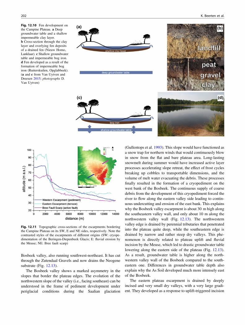
The typical fens that are distributed all over the CampinePlateau landscape are rainwater-fed bogs that can be typi-fied according to their position in the landscape (Paulissen1984) (Fig. 12.10). One type is typical for the southern partof the Campine Plateau, southeast of the Bosbeek valley,where groundwater levels are very low, down to 20 m andsometimes even almost 40 m below the surface. This typeof bog developed where aeolian deflation removed any finesand material that could have been accumulated on top of ahydraulically impermeable clay or silt bed in the top layersof the Zutendaal Gravel. Consequently, a shallow lakecould develop in this depression in which peat couldaccumulate. Another fen type is typical for the northwesternpart of the plateau, northwest of the Bosbeek, wheregroundwater levels are much shallower, less than 5 mdeep. Here, the hydraulic barrier developed as an iron-richB-horizon in response to soil formation processes inblowout hollows. During episodes with elevated ground-water level, bog iron could further develop from precipita-tion of dissolved iron in seepage water, enhancing the roleof the hydraulic barrier.
12.4 Geomorphological Highlights
12.4.1 Escarpments
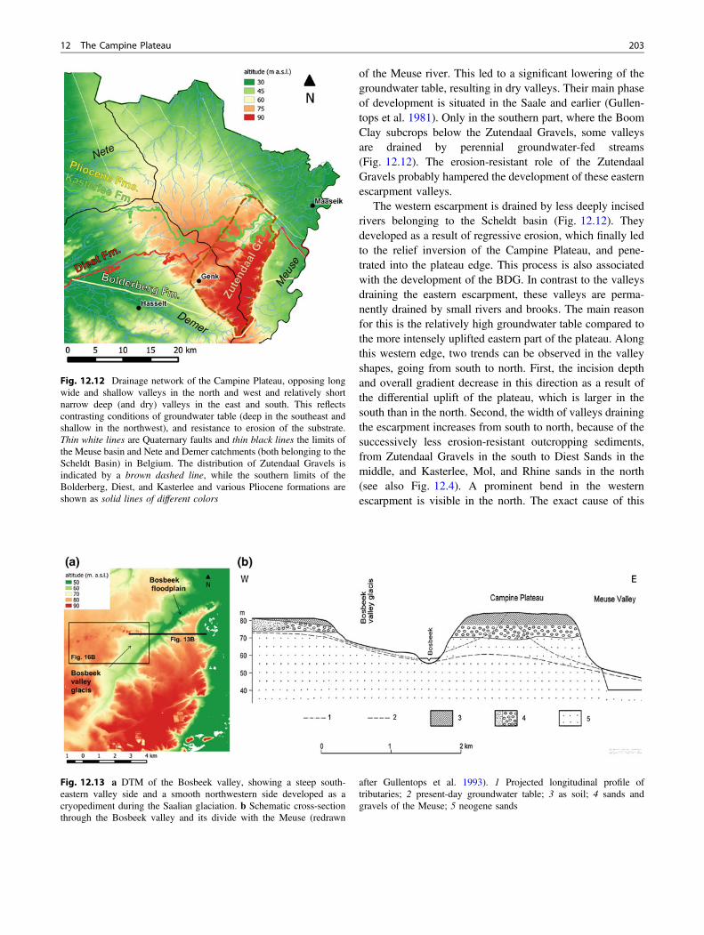
The shape of the Campine Plateau is determined by threeprominent escarpments, with different origins. The south-western escarpment developed in response to the formationof a pediment. This pediment forms the transition from the
Campine Plateau to the river valleys that drain the Scheldtbasin (Fig. 12.11). The top of the plateau is studded withresidual gravels hampering erosion at this location. The totalvertical difference between the plateau and the Demerfloodplain that drains the pediment in the west is ca. 50 m.The escarpment itself is ca. 15 m high, while the pedimentsurface shows a regular dip from ca. 60 to 30 m. Thesteepest slope is less than 10% over a horizontal distance of50 m.
The total height difference between the plateau and theMeuse Valley in the east is also ca. 50 m. However, themorphology of the eastern escarpment is completely differ-ent from the western one (Fig. 12.11). Much of the heightdifference takes place over a horizontal distance of less than1 km, causing the eastern slope to be much steeper than thewestern one. The steepest slope sections can easily reach20% over a distance of 50 m. The remaining 5–10 m heightdifference is accommodated by river terraces that are sepa-rated by small escarpments, usually only several m high,until the actual floodplain is reached.
The northeastern escarpment (Bree Fault Scarp) is tec-tonic in origin, and can clearly be observed near the town ofBree (Fig. 12.11). Its morphology takes an intermediateposition in between the western and eastern escarpments.About two-third of the 30 m vertical height differencebetween the Campine Plateau and Bocholt Plain occurswithin a horizontal distance of 1 km. The remaining 10 m isdue to the accumulation of slope deposits at the foot of theescarpment. The steepest part of the slope may reach 10–15% over a horizontal distance of 50–100 m.
12.4.2 Development of the HydrographicalNetwork on the Campine Plateau
The water divide between the Meuse (east) and Scheldt(west) river basins runs through the town of Water-schei (which literally means ‘Waterdivide’). It is situatedcloser to the western boundary of the plateau than the easternone (Fig. 12.12). Drainage towards the north and northeastdeveloped through small brooks and rivers that penetrateddeep into the plateau. Brooks that drain in northwarddirection have a very low gradient and run in very shallowfloodplains. Other brooks and rivers make a distinct bendtowards the northeast when passing the Bree Fault Scarpalong the northeastern edge of the plateau. Although theirupper courses trend N–S, they seem to have been respondingto tectonic activity along the Feldbiss fault, finding a newcourse straight into the sinking Bocholt Plain. The gradientand valley depth are larger than those of the northwardsflowing rivers, because of the larger and more abrupt heightdifference between the Bocholt Plain and Campine Plateaualong this fault segment. The most striking feature is the
12 The Campine Plateau 201
Bosbeek valley, also running southwest-northeast. It has cutthrough the Zutendaal Gravels and now drains the Neogenesubstrate (Fig. 12.13).
The Bosbeek valley shows a marked asymmetry in theslopes that border the plateau edges. The evolution of thenorthwestern slope of the valley (i.e., facing southeast) can beunderstood in the frame of pediment development underperiglacial conditions during the Saalian glaciation
(Gullentops et al. 1993). This slope would have functioned asa snow trap for northern winds that would continuously blowin snow from the flat and bare plateau area. Long-lastingsnowmelt during summer would have increased active layerprocesses accelerating slope retreat, the effect of frost cyclesbreaking up cobbles to transportable dimensions, and thevolume of melt water evacuating the debris. These processesfinally resulted in the formation of a cryopediment on thewest bank of the Bosbeek. The continuous supply of coarsedebris from the development of this cryopediment forced theriver to flow along the eastern valley side leading to contin-uous undercutting and erosion of the east bank. This explainswhy the Bosbeek valley escarpment is about 30 m high alongthe southeastern valley wall, and only about 10 m along thenorthwestern valley wall (Fig. 12.13). The northwesternvalley edge is drained by perennial tributaries that penetratedinto the plateau quite deep, while the southeastern edge isdrained by narrow and rather steep dry valleys. This phe-nomenon is directly related to plateau uplift and fluvialincision by the Meuse, which led to drastic groundwater tablelowering along the eastern side of the plateau (Fig. 12.13).As a result, groundwater table is higher along the north-western valley wall of the Bosbeek compared to the south-eastern one. Differences in groundwater table depth alsoexplain why the As Soil developed much more intensely eastof the Bosbeek.
The eastern plateau escarpment is drained by deeplyincised and very small dry valleys, with a very large gradi-ent. They developed as a response to uplift-triggered incision
Fig. 12.10 Fen development onthe Campine Plateau. a Deepgroundwater table and a shallowimpermeable clay layer.b Cross-section through the claylayer and overlying fen depositsof a drained fen (Nieuw Homo,Lanklaar). c Shallow groundwatertable and impermeable bog iron.d Fen developed as a result of theformation of impermeable bogiron (Ruiterskuilen, Opglabbeek).(a and c from Van Uytven andDreesen 2015; photographs D.Van Uytven)
Fig. 12.11 Topographic cross-sections of the escarpments borderingthe Campine Plateau on its SW, E and NE sides, respectively. Note thecontrasted styles of the escarpments of different origins (SW: cryope-dimentation of the Beringen-Diepenbeek Glacis; E: fluvial erosion bythe Meuse; NE: Bree fault scarp)
202 K. Beerten et al.
of the Meuse river. This led to a significant lowering of thegroundwater table, resulting in dry valleys. Their main phaseof development is situated in the Saale and earlier (Gullen-tops et al. 1981). Only in the southern part, where the BoomClay subcrops below the Zutendaal Gravels, some valleysare drained by perennial groundwater-fed streams(Fig. 12.12). The erosion-resistant role of the ZutendaalGravels probably hampered the development of these easternescarpment valleys.
The western escarpment is drained by less deeply incisedrivers belonging to the Scheldt basin (Fig. 12.12). Theydeveloped as a result of regressive erosion, which finally ledto the relief inversion of the Campine Plateau, and pene-trated into the plateau edge. This process is also associatedwith the development of the BDG. In contrast to the valleysdraining the eastern escarpment, these valleys are perma-nently drained by small rivers and brooks. The main reasonfor this is the relatively high groundwater table compared tothe more intensely uplifted eastern part of the plateau. Alongthis western edge, two trends can be observed in the valleyshapes, going from south to north. First, the incision depthand overall gradient decrease in this direction as a result ofthe differential uplift of the plateau, which is larger in thesouth than in the north. Second, the width of valleys drainingthe escarpment increases from south to north, because of thesuccessively less erosion-resistant outcropping sediments,from Zutendaal Gravels in the south to Diest Sands in themiddle, and Kasterlee, Mol, and Rhine sands in the north(see also Fig. 12.4). A prominent bend in the westernescarpment is visible in the north. The exact cause of this
Fig. 12.12 Drainage network of the Campine Plateau, opposing longwide and shallow valleys in the north and west and relatively shortnarrow deep (and dry) valleys in the east and south. This reflectscontrasting conditions of groundwater table (deep in the southeast andshallow in the northwest), and resistance to erosion of the substrate.Thin white lines are Quaternary faults and thin black lines the limits ofthe Meuse basin and Nete and Demer catchments (both belonging to theScheldt Basin) in Belgium. The distribution of Zutendaal Gravels isindicated by a brown dashed line, while the southern limits of theBolderberg, Diest, and Kasterlee and various Pliocene formations areshown as solid lines of different colors
Fig. 12.13 a DTM of the Bosbeek valley, showing a steep south-eastern valley side and a smooth northwestern side developed as acryopediment during the Saalian glaciation. b Schematic cross-sectionthrough the Bosbeek valley and its divide with the Meuse (redrawn
after Gullentops et al. 1993). 1 Projected longitudinal profile oftributaries; 2 present-day groundwater table; 3 as soil; 4 sands andgravels of the Meuse; 5 neogene sands
12 The Campine Plateau 203

bend is not clear, but it is probably related to the presence ofthe Rauw fault, the difference in resistance to erosionbetween the indurated Diest Sands in the south and the MolSands in the north, and the role of regressive erosion in theNete catchment (see above).
12.4.3 Preserved Natural Resources: MeuseGravels, Rhine Sands, Mol Sandsand Bolderberg Sands
12.4.3.1 Meuse GravelsThe Zutendaal Gravels run in a southwest-northeast direc-tion as a 5 km wide strip on the eastern side of the plateau,eroding the underlying Winterslag Sands and Neogene units.The gravel sheet is up to 15 m thick but is thinning towardsthe north and south. Extent, thickness, and elevated positionof the gravel unit make it a unique morphological feature inWestern Europe. The Zutendaal Gravels are characterized bya basal channel-lag deposit consisting of cobbles and larger(ice-rafted) boulders (De Brue et al. 2015) (Fig. 12.14a). Thegravel deposits form an aggrading unit, deposited duringdifferent aggrading cycles, each cycle consisting of a coarserchannel-lag deposit at the base, fining up to fine gravel oreven a sand layer or a clay lens at the top (Gullentops et al.1981; Paulissen 1983). Each cycle signifies deposition in abroad shallow channel. Usually, the gravels arematrix-supported by sand or finer material. They are gen-erally interpreted as a cold-climate braided river deposit.Their characteristics are completely different than those ofthe Holocene Meuse, which displays graded point bargravels, several meters thick, capped by silty and clayeyfloodplain deposits, 2–3 m thick. During deposition of theZutendaal Gravels, sediment supply was guaranteed by frostweathering during cold periods, under periglacial circum-stances. Subsequent snowmelt during early summer causedpeak discharge in the tributaries and main channel, pro-moting the transport of very coarse material.
De Brue et al. (2015) investigated the possibility of aclassical fluvial transport mode for the largest boulders—most of which exceed 50 cm and may reach up to 200 cm inintermediate axis and some of them weighting several tons—on the base of empirical hydraulic transport thresholds forgravel bed rivers. Results indicate that hydraulic transport ofboulders with intermediate diameters <1 m could haveoccurred within limited reaches of the palaeoriver, morespecifically in the palaeo-Amblève tributary. However, thesmall slope gradient of the palaeo-Meuse most probablyinhibited boulder movement by hydraulic forces only.
Therefore, ice-rafted transport of large boulders is favoredhere, referring to the existence of recent analogues (“blocsglaciers”) in the estuary of the St-Lawrence river of Québec(Dionne 2003) and according to observations and
calculations of the transport capacity of ice in the catchmentarea of the Amblève river by Collard et al. (2012, see alsoChap. 6). Furthermore, huge blocks of rock types sensitiveto physical weathering, such as phyllites and microgranites(often affected by diaclases), would never have reached theCampine area by normal fluvial transport without breakinginto smaller pieces.
The composition of the gravel undoubtedly points to asouthern origin, in particular the Ardennes and the Vosgesarea (northern France). Therefore, theMeuse and its tributaries(including also the Moselle) can be considered as the onlytransport agent for these gravels. The Zutendaal Gravels dis-play a broad lithological spectrum of weathering-resistantrock types, derived from various Palaeozoic throughMeso-Cenozoic geological sources. These include varioushard Cambrian quartzites and vein quartz, Lower-Middle Devonian conglomerates and sandstones, Lower-Carboniferous phtanites and silicified oolitic limestones,Cretaceous flints, Tertiary quartz arenites (silcretes) and flintgravels. The striking absence of Palaeozoic and Mesozoiclimestone pebbles or boulders is related to chemical weath-ering before or after transport and deposition of the gravels.Exceptionally, Cambrian-Ordovician phyllites, Late Devo-nian microgranites (e.g., the “porphyre de Mairupt”) anddiabases occur within the Zutendaal Gravels as huge ice-raftedboulders. The latter igneous rocks have been derived fromdyke swarms in theRocroi area, SWArdenne. Finally, pebblesof Palaeozoic granites and Triassic Buntsandstein representsome minor but most characteristic constituents that point to aparticular provenance area—theVosges—and hence transportvia theMoselleRiver (Bosch 1974, 1992;Dreesen et al. 2014).Flint, derived from upstream Cretaceous chalk formations, isalso a very typical component.
12.4.3.2 Rhine SandsThe Rhine facies of the Campine Plateau consists of mediumto coarse sand, with low clay and silt content, and occa-sionally containing fine and coarse gravel (Paulissen 1983).Sedimentation took place in wide and shallow channels,probably in a braided river system during glacial stadials orinterstadials because a typical fine-grained floodplain faciesis absent in these deposits (Fig. 12.14b). Usually, thedeposits are arranged in fining upward several-meters-thicksequences. Large boulders and blocks are lacking. Rhinedeposits can be found as a deep southwestern bend, coveringthe western and northwestern part of the Campine Plateau.Along the western edge of the plateau, the sands are erodedand preserved as a residual gravel layer, often containingventifacts (van Mechelen 1982). Rhine deposits occasionallycontain gravel that originates from the Alps, the Germanmiddle mountains and the Ardennes-Eifel massif. Gravel,and most notably granule gravel (2–4 mm), is rich in quartz,usually above 60%, while flint fragments are very rare.
204 K. Beerten et al.

These deposits are probably laterally equivalent to theWinterslag Sands, which occupy more or less the central partof the plateau, running southwest-northeast along a 10 kmwide zone (Fig. 12.5).
12.4.3.3 Mol SandsIn the northwest, the Rhine sands overlay a thick unit ofwhite to brown relatively pure quartz sands with two distinctlignite layers. These sands and lignite layers are known asthe Mol Formation (Fig. 12.14c). They were depositedduring the Pliocene in a large estuary fed by the rivers Rhineand Meuse, as attested by the presence of “kieselooliths”(pebbles of silicified oolitic limestone) near the base of theformation. During periods of graben subsidence, thick peatlayers developed in a swampy environment, and weretransformed into lignites during subsequent burial underquartz sands. The sands in the Mol Formation are fine tomedium-grained, while clay particles and glauconite arevirtually absent. Post-depositional bleaching of the sand as aresult of dissolved organic acids in the infiltrating rain water
gave the sands their pureness and white appearance, suchthat is very suitable in the glass, ceramics, chemical andmetallurgical industries (Gullentops and Wouters 1996).
12.4.3.4 Bolderberg SandsOn the southeastern part of Campine Plateau, the ZutendaalGravel blanket overlays about 40 m of fine-grained white toslightly yellowish quartz-rich sands (Fig. 12.14d). Thesesands belong to the Lower Miocene (Burdigalian) Bolder-berg Formation and correspond to shallow-marine depositsin a North Sea bay bordering the Roer Valley. The sourcematerial probably originated from the weathered and there-fore quartz-rich material at the margins of the southern NorthSea Basin in Belgium and adjacent areas. Their uniform finegrain-size distribution (average 200 µm), good sorting, aswell as mineralogical composition (slightly glauconite-bearing) and the presence of herringbone cross-bedding,point to longshore transport, coastal sorting by tidal currentsin an estuarine depositional environment (Gullentops 1973).The Bolderberg Sands display a threefold subdivision due to
Fig. 12.14 Natural resources inthe Campine area. a Coarsematrix-supported gravel depositedby the Meuse and weathered intothe As Soil; the length of thelongest axis of the biggest boulderis ca. 0.6 m (‘Kikbeek’ quarry,Maasmechelen; reproduced fromDreesen et al. 2005). b Coarsesand deposited by the Rhine, noobvious weathering (‘BlauweKei’ quarry, Lommel;photograph M. Gedeon). c Whitequartz sand and lignite of the MolFormation (Blauwe Kei quarry,Lommel; Photograph K.Beerten). d Outcrop in theBolderberg Formation showingalternations of bleached quartzsand and lignite (Kikbeek quarry,Opgrimbie; reproduced fromDreesen et al. 2005)
12 The Campine Plateau 205

a continental phase interrupting the shallow-marine sandsedimentation. During a short withdrawal of the sea,extensive coastal marshes and back-swamps developed(analogous to the actual Everglades in Florida or the Oke-fenokee swamps in Southern Georgia, USA) leading to theformation of the so-called Kikbeek Lignite (averaging 3 min thickness). This lignite is mainly composed of driftwoodalthough swamp trees grew in place, as evidenced bynumerous roots that penetrate the underlying sands. Thisseam is of the same age as the lignite seams of the RoerValley in the Netherlands (Heksenberg Member of themarine Breda Formation) that correlate well with thewell-known thick lignite deposits exploited for fuel in theGarzweiler, Frimmersdorf and Hambach quarries of theLower Rhine Basin in Germany (Van der Meulen et al.2009). Early-diagenetic leaching by humic acids originatingfrom the peat affected the underlying sands: so, non-quartzcomponents were dissolved resulting in the creation of thefamous Miocene glass-sands or “silversands” of Maas-mechelen. These worldwide reputed glass-sands are stillextensively quarried on the Campine Plateau because of theirpureness (iron content is less than 0.01% Fe2O3, AI2O3
content less than 0.025%). Moreover, this extraction activitywas also responsible for the creation of deep extraction pits,resulting in the creation of important geological outcropsthat have been recently reclaimed into highly valuable naturereserves and important geoheritage sites (Dreesen et al.2005).
12.4.4 Polygonal Soils and Cryoturbations
In the uppermost part of the Zutendaal Gravel, right belowthe Late Pleistocene-Holocene aeolian sands, spectacularexamples of a particular type of cryoturbation occur(Fig. 12.15). In section, these features look like verticaltongues or flames (“involutions”) up to 2–3 m in length,whereby the pebble axes are vertically oriented. In planesection (at the surface), these tongues form a characteristicnetwork of large polygons with diameters of less than 1 mup to several meters. The core of these gravel polygons isessentially made of sandy material, and their center isslightly raised (Fig. 12.15b). According to Paulissen (1970),this patterned ground type deformation (called “sortedpolygons”) is characteristic of periglacial areas undergoingpermafrost conditions. These peculiar forms most probablyoriginated within the active layer of the permafrost. Frostheave is generally seen as the main mechanism behind theformation of sorted patterned ground (Pissart 1987; VanVliet-Lanoë 2014; Yamagishi and Matsuoka 2015).Dependent on grain size (fine sands and silts are mostfrost-susceptible), freezing rate, and available moisture
(ensured where a perched water table is present above thefrozen ground during summer), lenses of segregation icedevelop gradually within the active layer with seasonalfreeze-thaw cycles, causing soil heave and erecting elon-gated gravel (Pissart 1969). While differential frost heave,mainly related to lateral variations in grain size or soilmoisture availability, may be responsible for the polygonalpattern, sometimes also guided by a net of desiccationcracks, the contrast between gravel involutions and cells offiner material is attributed to frost sorting, vertical and lat-eral, by freezing and thawing. These spectacular polygonsbear witness to the harsh (cold and dry) climatic conditionsthat prevailed in Campine area during the last ice ages,particularly during the Late Weichselian (ca. 20 ka). Theyare currently characteristic of arctic regions or tundra areaslike those located around the Arctic Circle (Canada, Spits-bergen, Greenland).
12.4.5 Late Glacial and Holocene Dunes
Among the most striking landforms topping the CampinePlateau are parabolic and longitudinal dunes. They caneasily be identified on DTM images (Figs. 12.1 and 12.9)and historical maps. The dune complex of Hoeverbergen(Fig. 12.1c) was originally studied by Gullentops (1957). Itis a parabolic dune, ca. 1 km wide (between tips), ca. 2 kmlong (along the dune axis) and up to 10 m high. Handaugerings allowed for reconstructing the original surface bymapping the palaeosoil that stabilized the dune, in responseto climatic amelioration and vegetation development. Thedune itself probably developed during the Late Glacial(Younger Dryas), since it is underlain by a bleached horizon,which is interpreted as the Usselo soil of Allerød/EarlyYounger Dryas age (Derese et al. 2012). The dominant winddirection during dune development was from the southwestas is evidenced by the steep dip angle (26°) of individualsand beds at the northeastern leeward side of the dune(Fig. 12.16a). The soil that is preserved inside the blown-outsurface is described as a hydromorphic soil, such thatdeflation is supposed to have continued until the water tablewas reached. The northeastern tip of the dune is blown out ata later stage during landscape development, the blowoutsand being deposited towards the east as small isolateddunes 1–2 m high. A similar dune complex is present nearKattenbos and Maatheide (Lommel). The core of the dune atMaatheide is shown to contain the Late Glacial Usselo soil(Derese et al. 2012). Holocene reactivation of the Kattenbosdune as a result of agricultural activity (deforestation,herding, repeated use of tracks for herding, cutting of piecesof heath with roots and humus, called plaggen, as beddingfor cattle) caused newly eroded sand to drift onto the older
206 K. Beerten et al.

dune surface posterior to the development of a podzol soil(Fig. 12.16b).
A different type of dune complex is the one on the westbank of the Bosbeek, called the “Duinengordel” (Fig. 12.16c). It consists of an array of small parabolic dunes, ca. 200 mwide, 200–400 m long (along the dune axis) and up to 15 mhigh. The complex itself is about 8 km long, and more or lessoriented east-west. Typically, the northeast-facing leewardslope of the individual dunes is much steeper than thesouthwest-facing slope, indicating that they developed underinfluence of southwesterlies. The dunes are considered to berelatively young. On the one hand, the absence of LateGlacial palaeosoils in their core suggests that they did notdevelop from a Late Glacial dune, as is the case in Lommel.On the other hand, traces of soil formation on the dune top areabsent, suggesting that they are still active, especially in thoseareas where vegetation is lacking. A particular feature in thisrespect is the dune top of the Oudsberg, the highest top of thedune complex (Fig. 12.16d). Aeolian deflation facilitated by
over-recreation of the dune led to a system of excavated treeroots. The development of the dune complex is probablyrelated to deflation from ploughed fields south of it.
About 200 circular depressions with an average diameterof 140 m and rims averaging 2.5 m in height have beendiscovered by using panchromatic and LIDAR-imaging(Laser Imaging Detection And Ranging) in the BocholtPlain, NE of the Campine Plateau. Field surveys demon-strated that these landforms (with low conservation poten-tial) actually represent blowouts or lunettes (Dusar et al.2008). Their exact age is still not clear but most probablythey were formed as a result of deforestation during the earlyNeolithicum.
12.4.6 Groundwater Silcretes
About 1.5 m below the base of the Kikbeek lignite seams,ash-white quartz arenitic sandstones occur (the so-called
Fig. 12.15 a Development oflarge cryoturbation structures inthe active layer above apermafrost table in graveldeposits, according to Paulissen(1970) (modified from Dreesenet al. 2005). b Polygonal soilpattern in the top layers of theZutendaal Gravels, withlarge-scale involutions and flamescontaining vertically alignedgravel (‘Salamander’ quarry,Maasmechelen; reproduced fromDreesen et al. 2005)
12 The Campine Plateau 207

Bolderian Sandstones) in the bleached Bolderberg sand,forming thick plates or thick lenticular beds (Gulinck 1961)that reach volumes of several m3 (Fig. 12.17). These sil-cretes often display particular organic or anthropomorphicforms, leading to their naming “grès mamelonné” in French.Silicification of the sand, often incomplete, commonlyoccurs through quartz overgrowth on the quartz grains. Thesilcrete blocks contain small circular pits at their uppersurface and vertical root traces, pointing to the presence of apeat (lignite) layer above. Although different stratigraphiclevels display silicification in the subsurface of the provinceof Limburg, silcretes most frequently formed during conti-nental episodes of the Thanetian (Upper Paleocene) in Bel-gium and Northern France (Dreesen and Dusar 2012).Silcrete formation is related to post-depositional groundwa-ter circulation and the release of silica accompanying acid
leaching of the host material or adjacent strata (Ullyott andNash 2006). Demoulin (1990) distinguished several types ofsilicified Tertiary sandstones in Southern Limburg (NL) and atthe northern border of the Ardennes (Hautes Fagnes and Paysde Herve). The Miocene quartz arenites of the High Campinearea belong to Demoulin’s Nievelstein type, typically associ-ated with lignite deposits. The Miocene silcretes show stronganalogies with the sarsen stones of southern England and the“Braunkohlequartzite” of the German Lower Rhine area.Moreover, they have been locally used as a vernacular buildingstone in the province of Limburg (Dreesen et al. 2001). Finally,when some of these huge, massive stones (megaliths) becameunearthed through erosion of the enveloping sand, they havebeen locally used as a grinding stone for flint tools duringprehistoric times, such as the sandstone blocks of the Holsteen,in the Zonhoven area (Huyghe 1990).
Fig. 12.16 a. Detail topographic maps of the Hoeverbergen dune(from Gullentops 1957). b. Typical profile showing drift sand migratingover a podzol soil developed on top of the Kattenbos dune nearLommel (photograph D. Van Uytven). c Detail DTM of the
‘Duinengordel’ dunes. d The Oudsberg, the highest summit of thedune system (photograph D. Van Uytven). See also Fig. 12.1c for thelocation of the Hoeverbergen and Kattenbos dunes
208 K. Beerten et al.
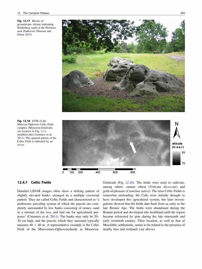
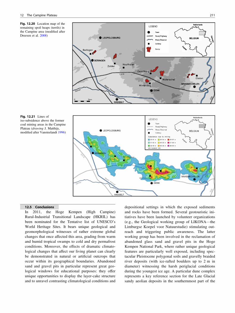
12.4.7 Celtic Fields
Detailed LIDAR images often show a striking pattern ofslightly elevated banks, arranged in a multiple crossroadpattern. They are called Celtic Fields and characterized as ‘aprehistoric parceling system of which the parcels are com-pletely surrounded by low banks consisting of stones, sandor a mixture of the two, and laid out for agricultural pur-poses’ (Creemers et al. 2011). The banks may only be 20–30 cm high, and the parcels which they surround typicallymeasure 40 � 40 m. A representative example is the CelticField of the Muisvenner-Ophovenerheide in Meeuwen-
Gruitrode (Fig. 12.18). The fields were used to cultivate,among others, emmer wheat (Triticum dicoccum) andgold-of-pleasure (Camelina sativa). The term Celtic Fields issomewhat misleading: the Celts were initially thought tohave developed this agricultural system, but later investi-gations showed that the fields date back from as early as thelate Bronze Age. The fields were abandoned during theRoman period and developed into heathland until the regionbecame reforested by pine during the late nineteenth andearly twentieth century. Their location, as well as that ofMesolithic settlements, seems to be related to the presence ofnearby fens and wetlands (see above).
Fig. 12.17 Blocks ofgroundwater silcrete induratingBolderberg sands at the Holsteen,near Zonhoven (Dreesen andDusar 2012)
Fig. 12.18 DTM of theMuisven-Ophoven Celtic Fieldcomplex (Meeuwen-Gruitrode,see location in Fig. 12.1;modified after Creemers et al.2011). The squared pattern of theCeltic Field is indicated by anarrow
12 The Campine Plateau 209

12.4.8 Impacts of Coal Miningon the Geomorphology of the CampinePlateau
Coal mining tips (spoil heaps or waste dumps, named “ter-rils” or “steenbergen”) represent enormous beacons in theCampine landscape and they are regarded as true sociocul-tural heritage (Fig. 12.19). They represent silent witnesses ofthe luxurious tropical rain forests that once ruled the areaduring the Late Carboniferous, generating numerous coallayers in the deep subsurface of the Campine basin. Theirdiscovery in 1901 meant the beginning of a coal rush. Fromthe first coal production in 1917 until the closure of the lastcolliery in 1992, over 441 million tons of coal have beenproduced from seven different collieries, with an equivalentamount of coal waste. The latter mainly consists of mud-stone (over 70%) with minor amounts of siltstone, sand-stone, coal, and carbonaceous shale. After final closure ofthe collieries, the coal mining tips and coal sludge basins(liquid waste generated by washing of the crushed coal) werepartly reclaimed from 1993 to 2000, because of environ-mental regulations. Reclaiming measures concentrated onremodeling the dumps, aiming at stabilizing the slopes andavoiding acid coal mine waste drainage. In order to furtherreduce erosion (e.g., through gully formation and debrissliding) greening of the dumps was carried out byhydroseeding. Due to the latter remodeling, the original out-line, shape and location of the dumps have been considerablychanged (Fig. 12.20). The coal mining tips originally reached
between 70 and 110 m in height. Although they representenormous reserves of secondary raw materials for theceramics industry (Dreesen et al. 2008), the ones that have notbeen remodeled or reclaimed have become nature reserves,hosting thermophilic and halophilic fauna and flora.
Moreover, this deep coal mining activity caused impor-tant and extensive ground subsidence. Maps with estimatediso-subsidence lines have been calculated in collaborationwith the Campine Collieries between 1981 and 1985(Vansteelandt 1996) showing subsidence values exceeding6–8 m (e.g., in the central Zwartberg–Waterschei area). Thissubsidence is related to the extraction of several superim-posed coal layers and to strong groundwater (mine water)pumping (Fig. 12.21). Moreover, with the help of radarinterferometry (PS-inSAR) using satellite data from 1992through 2005, contrasting ground movements have beenreported over the abandoned Campine coal mining area(Devleeschouwer et al., 2007). The collieries in the easternpart of the coal basin closed much earlier (1966–1987) thanthose in the western part (1992). As a result and in contrastwith residual mining subsidence in the western part (−4 to−14 mm/year between 1992 and 2000), a distinct uplift hasbeen recorded in the eastern part (+3 to +23 mm/year). Thisuplift apparently results from poro-elastic rebound of theeastern area when flooding of the underground mine work-ing subsequent to the end of mine water pumping induced apore-pressure increase. Meanwhile, also the western part ofthe Campine coal field has reversed to uplift mode (Vervoort2016; Bejarano-Urrego et al. 2016).
Fig. 12.19 Overgrown coalmining tip (“terril”) of Eisden.Groundwater crops out inabandoned gravel pits(Photograph M. Bex)
210 K. Beerten et al.
12.5 ConclusionsIn 2011, the Hoge Kempen (High Campine)Rural-Industrial Transitional Landscape (HKRIL) hasbeen nominated for the Tentative list of UNESCO’sWorld Heritage Sites. It bears unique geological andgeomorphological witnesses of rather extreme globalchanges that once affected this area, grading from warmand humid tropical swamps to cold and dry permafrostconditions. Moreover, the effects of dramatic climato-logical changes that affect our living planet can clearlybe demonstrated in natural or artificial outcrops thatoccur within its geographical boundaries. Abandonedsand and gravel pits in particular represent great geo-logical windows for educational purposes: they offerunique opportunities to display the layer-cake structureand to unravel contrasting climatological conditions and
depositional settings in which the exposed sedimentsand rocks have been formed. Several geotouristic ini-tiatives have been launched by volunteer organizations(e.g., the Geological working group of LIKONA—theLimburgse Koepel voor Natuurstudie) stimulating out-reach and triggering public awareness. The latterworking group has been involved in the reclamation ofabandoned glass sand and gravel pits in the HogeKempen National Park, where rather unique geologicalfeatures are particularly well exposed, including spec-tacular Pleistocene polygonal soils and gravelly braidedriver deposits (with ice-rafted boulders up to 2 m indiameter) witnessing the harsh periglacial conditionsduring the youngest ice age. A particular dune complexrepresents a key reference section for the Late Glacialsandy aeolian deposits in the southernmost part of the
Fig. 12.21 Lines ofiso-subsidence above the formercoal mining areas in the CampinePlateau (drawing J. Matthijs,modified after Vansteelandt 1996)
Fig. 12.20 Location map of theremaining spoil heaps (terrils) inthe Campine area (modified afterDreesen et al. 2008)
12 The Campine Plateau 211
NW European coversand belt, because of excellentpreservation of fossilized soils, rarely seen elsewhere.
Huge ice-rafted boulders embedded in braided riverdeposits display a broad lithologic spectrum representativeof the geology of the upstream area of the Meuse riverbasin. Below this Pleistocene gravel blanket, pure whitequartz sands occur, the origin of which is related to thepresence of lignite formed during the Miocene in coastalmarshes, analogous to the recent Everglades or Okefenokeeswamps in the USA. The lignite as well as the rocks andfossils in the coal mining tips in the direct surroundingsprovide strong evidence for past global climate change.A selection of ice-rafted boulders, representative of differ-ent geological stages, were removed from the graveldeposits and set into a geological “rock garden” offering anew destination for geography school classes and theirteachers. A colorful brochure allows the general public toidentify pebbles that occur everywhere throughout theNational Park and that represent its hallmark (Dreesen2007). Recently a new geological biking route has been setup, explaining the complex relationship between subsur-face, landscape, flora, and cultural history of the HighCampine area (Van Uytven and Dreesen 2015).
The Campine Plateau is a unique geomorphologicalobject and one of the best-kept examples in Europe of anenormous alluvial fan-like gravel and sand depositformed during the Middle Pleistocene. Its present shape isthe result of interfering erosional and tectonic processes.The southern tip, the western and northeastern boundariesare all (in)directly fault-related, this particular tectonicconfiguration controlling the fluvial development of thearea around the Early-Middle Pleistocene transition. Oncetectonic uplift had raised the Eastern Campine Block, thatlargely coincides with the Campine Plateau, the fluvialdeposits were directly responsible for the preservation ofthe plateau as a morphological entity in topographicinversion. Aeolian processes actively reshaped the pla-teau surface during the Late Pleistocene and Holocene.Soil erosion and depletion of nutrients due to intensivegrazing had to be countered by massive pine planation ontop of the plateau. These could easily thrive on the rela-tively dry sandy and stony soils. Locally, clay or loamlenses on top of the gravel deposits entail completelydifferent hydrological conditions such that rainwater-fedfens could develop. Coal extraction has led to specificanthropogenic geomorphic features, such as big spoilheaps and subsidence phenomena above the formerCampine collieries.
Acknowledgements Michiel Dusar is gratefully thanked for criticallyreading a late draft of the chapter and helping improve the text.
References
Beerten K (2003) Vroeg- en Midden-Pleistocene sedimen-tatiegeschiedenis van Maas en Rijn in de Belgische Roergraben –
Onderzoeksresultaten van gekernde boringen (Project VLA01-3.1.3.).Ministerie van de Vlaamse Gemeenschap, Brussel. http://www.vlaanderen.be/nl/publicaties/detail/vroeg-en-midden-pleistocene-sedimentatiegeschiedenis-van-maas-en-rijn-in-de-belgische-roergraben.Accessed 5 Feb 2015
Beerten K (2005a) Toelichting bij de Quartairgeologische kaart,kaartblad 26 Rekem. Vlaamse Overheid, Dienst Natuurlijke Rijk-dommen, Brussels
Beerten K (2005b) Toelichting bij de Quartairgeologische kaart,kaartblad 10-18 Maaseik. Vlaamse Overheid, Dienst NatuurlijkeRijkdommen, Brussels
Beerten K (2006) Toelichting bij de Quartairgeologische kaart,kaartblad 17 Mol. Vlaamse Overheid, Dienst Natuurlijke Rijkdom-men, Brussels
Beerten K, Brabers B, Bosch P, Gullentops F (1999) The passage of theFeldbiss Bundle through the Maas Valley. Aardkundige Mededelin-gen 9:153–158
Beerten K, Vandersmissen N, Deforce K, Vandenberghe N (2014) Latequaternary (15 ka to present) development of a sandy landscape inthe Mol area, Campine region, NE Belgium. J Quat Sci 29:433–444
Bejarano-Urrego L, Verstrynge E, Van Balen K, Wuyts V,Declercq PY (2016) Settlement-induced damage monitoring of ahistorical building located in a coal mining area using PS-InSAR.In: Proceedings of the CSHM-6: structural health monitoring of newand ageing infrastructure, Belfast, N Ireland, May 26–27
Bogemans F (2005) Technisch verslag bij de opmaak van dequartairgeologische overzichtskaart van Vlaanderen, schaal1:200.000. Ministerie van de Vlaamse Gemeenschap, AfdelingNatuurlijke Rijkdommen en Energie, Brussels
Bosch P (1974) Diabaas en porfiroïde als zwerfsteen in Zuid-LimburgseMaasterrassen. Grondboor en Hamer 6:110–118
Bosch P (1992) De herkomstgebieden van de Maasgesteenten.Grondboor en Hamer 3:57–64
Cohen K, Gibbard P (2011) Global chronostratigraphical correlationtable for the last 2.7 million years. Subcommission on QuaternaryStratigraphy (International Commission on Stratigraphy), Cam-bridge, England
Collard S, Juvigné E, Marion J-M, Mottequin B, Petit F (2012)L’origine des megalithes du Fond de Quarreux (Ardenne, Belgique).Bulletin de la Société Géographique de Liège 58:33–51
Creemers G, Meylemans E, Paesen J, De Bie M (2011) Laseraltemetrieen de kartering van Celtic Fields in de Belgische Kempen:mogelijkheden en toekomstperspectieven. Relicta 7:11–36
De Brue H, Poesen J, Notebaert B (2015) What was the transport modeof large boulders in the Campine Plateau and the lower Meusevalley during the mid-Pleistocene? Geomorphology 228:568–578
De Moor G, Pissart A (1992) Het Reliëf. In: Denis J (ed) Geografie vanBelgië. Gemeentekrediet, Brussel, pp 130–215
Demoulin A (1990) Les silicifications tertiaires de la bordure del’Ardenne et du Limbourg méridional (Europe NO). Zeitschrift fürGeomorpholopgie 34:179–197
Demoulin A, Hallot E (2009) Shape and amount of the quaternaryuplift of the western Rhenish shield and the Ardennes (westernEurope). Tectonophysics 474:696–708
Derese C, Vandenberghe D, Paulissen E, Van den haute P (2009)Revisiting a type locality for Late Glacial aeolian sand deposition inNW Europe: optical dating of the dune complex at Opgrimbie (NEBelgium). Geomorphology 109:27–35
212 K. Beerten et al.
Derese C, Vandenberghe D, Eggermont N, Bastiaens J, Annaert R, Vanden Haute P (2010) A medieval settlement caught in the sand:optical dating of sand-drifting at Pulle (N Belgium). QuatGeochronol 5:336–341
Derese C, Vandenberghe D, Van Gils M, Mees F, Paulissen E, Van denHaute P (2012) Final Palaeolithic settlements of the Campine region(NE Belgium) in their environmental context: optical age con-straints. Quatern Int 251:7–21
Devleeschouwer X, Declercq P-Y, DusarM, DebienA (2007) Contrastingground movements revealed by radar interferometry over abandonedcoal mines (Campine, Belgium). In: Proceedings of FRINGE 2007,workshop, European space agency, Frascati, Italy, vol 12
Dionne J-C (2003) Observations géomorphologiques sur les méga--blocs du secteur sud-est de la batture argileuse de la baie à l’Orignal,au parc du Bic, dans le Bas-Saint-Laurent (Québec). Géog PhysQuatern 57:95–101
Dreesen R (2007) Zoekkaart keien voor het Nationaal Park HogeKempen. Regionaal Landschap Kempen en Maasland & LIKONA
Dreesen R, Dusar M (2012) Duivelsstenen in Limburg: zwerfstenen,megalieten of getuigenstenen? LIKONA jaarboek 2011:14–29
Dreesen R, Dusar M, Doperé F (2001) Atlas natuursteen in Limburgsemonumenten. Geologie, beschrijving, herkomst en gebruik. Provin-cie Limburg, Het Groene Huis, Genk, pp 294
Dreesen R, Mareels J, Fries S (2005) De zandgroeve van Opgrimbie:een uitzonderlijk kijkvenster op de geologische geschiedenis van deHoge Kempen. LIKONA Jaarboek 2005:14–25
Dreesen R, Laenen B, Nielsen P, Matthijs J (2008) Assessment of coalwaste dump material as an alternative for primary raw materials inthe former coal mining district of the Campine area (N-Belgium).In: 33rd international geological congress, Oslo, Proceedings
Dreesen R, Janssen J, Van Uytven D (2014) Het grind ontleed:samenstelling en herkomst van de stenen in het Maasgrind.LIKONA-jaarboek 24:18–35
Dusar M, Langenaeker V (1992) De oostrand van het massief vanBrabant, met beschrijving van de geologische verkenningsboring teMartenslinde. Geol Surv Belg Prof Paper 255, 22 p
Dusar M, Matthijs J, Dreesen R, Poesen J (2008) Cirkelvormigedepressies in de vlakte van Bocholt. LIKONA jaarboek n° 17, 20–35
Felder W, Bosch P (1989) Geologische kaart van Zuid-Limburg enomgeving 1:50.000, Afzettingen van de Maas. Rijks GeologischeDienst, Heerlen
Geluk M, Duin E, Dusar M, Rijkers R, Van den Berg M, van Rooijen P(1994) Stratigraphy and tectonics of the Roer Valley Graben. GeolMijnbouw 73:129–141
Goossens J, Molemans J, Paulissen E, Theuwissen J (1983) Debegrenzing van de Kempen. Mededelingen van de Vereniging voorLimburgse Dialect- en Naamkunde 25:153–156
Gulinck M (1961) Note sur le Boldérien d’Opgrimbie (Campine) etremarques sur les grès “erratiques” du Limbourg. Bulletin de laSociété belge de Géologie 70:297–302
Gullentops F (1957) Quelques phénomènes géomorphologiques depuisle Pléni-Würm – Dunes paraboliques en Campine. Bulletin de laSociété belge de Géologie 66:86–95
Gullentops F (1973) Grainsize and mineralogy of Miocene glass-sandsof Maasmechelen, Belgian Limburg. Mededelingen Rijks Geolo-gische Dienst, Nieuwe Serie 23:25–34
Gullentops F, Claes S (1997) The Bilzen fault bundle (NE Belgium).Aardkundige Mededelingen 8:99–102
Gullentops F, Vandenberghe N (1995) Toelichtingen bij de geologischekaart van België, Vlaams Gewest, Kaartblad 17, Mol. BelgischeGeologische Dienst, Brussels
Gullentops F, Wouters L (1996) Delfstoffen in Vlaanderen. Ministerievan de Vlaamse Gemeenschap, Brussels
Gullentops F, Janssen J, Paulissen E (1993) Saalian nivation activity inthe Bosbeek valley, NE Belgium. Geol Mijnbouw 72:125–130
Gullentops F, Bogemans F, De Moor G, Paulissen E, Pissart A (2001)Quaternary lithostratigraphic units (Belgium). Geologica Belgica4:153–164
Gullentops F, Paulissen E, Vandenberghe J (1981) PeriglacialPhenomena in NE-Belgium. Biuletyn Peryglacjalny, 28:345–365
Gupta S, Collier J, Palmer-Felgate A, Potter G (2007) Catastrophicflooding origin of shelf valley systems in the english channel.Nature 448:342–345
Hoek W (2001) Vegetation response to the 14.7 and 11.5 ka cal. BPclimate transitions: is vegetation lagging climate? Global PlanetChange 30:103–115
Huyghe D (1990) De “Holsteen” te Zonhoven: geo-archeologie van eenprehistorisch landschap. Archeologie in Vlaanderen 1:31–54
Janssen J, Dreesen R (2010) Geologische fietsroute Tussen Kempen enMaas. LIKONA, Limburgse Koepel voor Natuurstudie, Genk 78 p
Juvigné E, Renard F (1992) Les terrasses de la Meuse de Liège àMaastricht. Annales de la Société Géologique de Belgique115:167–186
Kasse C, Vandenberghe D, De Corte F, Van den Haute P (2007) LateWeichselian fluvio-aeolian sands and coversands of the type localityGrubbenvorst (southern Netherlands): sedimentary environments,climate record and age. J Quat Sci 22:695–708
Matthijs J, Lanckacker T, De Koninck R, Deckers J, Lagrou D,Broothaers M (2013) Geologisch 3D lagenmodel van Vlaanderenen het Brussels Hoofdstedelijk Gewest – versie 2, G3Dv2. Vlaamseoverheid, Departement Leefmilieu, Natuur en Energie, AfdelingLand en Bodembescherming, Ondergrond, Natuurlijke Rijkdom-men, Brussel, 21 p
MACAR P (1938) Compte rendu de l’excursion du 24 avril 1938,consacrée à l’étude des terrasses de la Meuse entre Liège et’Ubagsberg (Limburg hollandais). Annales de la Société géologiquede Belgique, 61:187–217
Pannekoek A (1924) Einigen Notizien über die Terrassen in Mittel- undNord-Limburg: Natuurhistorisch Maandblad 13:305–336
Paulissen E (1970) Excursiegids: De geomorfologie van de LimburgseKempen. De Aardrijkskunde 86:1–48
Paulissen E (1973) De Morfologie en de Kwartairstratigrafie van deMaasvallei in Belgisch Limburg. Verh. Kon. Acad. Wetensch.,Letteren en Schone Kunsten v. België. Kl der Wetensch 127:1–266
Paulissen E (1983) Les nappes alluviales et les failles Quaternaires duPlateau de Campine. In: Robaszynski F, Dupuis C (eds) GuidesGéologiques Régionaux – Belgique. Masson, Paris, pp 167–170
Paulissen E., 1984. Het fysisch kader van Opglabbeek. In: Molemans J,Mertens J (eds) Opglabbeek, een rijk verleden, GemeentebestuurOpglabbeek, pp 29–56
Paulissen E (1997) Quaternary morphotectonics in the Belgian part ofthe Roer Graben. Aardkundige Mededelingen 8:131–134
Pissart A (1969) Le mécanisme périglaciaire dressant les pierres dans lesol. Résultats d’expériences. Comptes-rendus de l’Académie desSciences de Paris 268:3015–3017
Pissart A (1987) Géomorphologie périglaciaire. Rijksuniversiteit Gent,Faculteit van de Wetenschappen 133 p
Schokker J, Cleveringa P, Murray A, Wallinga J, Westerhoff W (2005)An OSL dated Middle and Late Quaternary sedimentary record inthe Roer Valley Graben (southeastern Netherlands). Quartern SciRev 24:2243–2264
Toucanne S, Zaragosi S, Bourillet J-F, Gibbard P, Eynaud F,Giraudeau J, Turon J-L, Cremer M, Cortijo E, Martinez P,Rossignol L (2009) A 1.2 Ma record of glaciation and fluvialdischarge from the Western European Atlantic margin. Quatern SciRev 28:2974–2981
12 The Campine Plateau 213

Ullyott J, Nash D (2006) Micromorphology and geochemistry ofgroundwater silcretes in the eastern South Downs, UK. Sedimen-tology 53:387–412
van Balen R, Houtgast R, Van der Wateren F, Vandenberghe J,Bogaart P (2000) Sediment budget and tectonic evolution of theMeuse catchment in the Ardennes and the Roer Valley Rift System.Global Planet Change 27:113–129
van den Berg M (1996) Fluvial sequences of the Meuse-a 10 Ma recordof neotectonics and climate change at various time-scales. Doctoraldissertation, Wageningen University, 181 p
Van der Meulen M, Westerhoff W, Menkovic A, Gruijters S,Dubelaar C, Maljers J (2009) Silica sand resources in TheNetherlands. Neth J Geosci 88:147–190
Van Mechelen J (1982) Geomorfologie van de westelijke rand van hetKempens Plateau en micro-eolisatieverschijnselen op grind. Unpub-lished master thesis, K.U.Leuven
Van Uytven D, Dreesen R (2015) Geologische fietsroute HogeKempen. LIKONA, Genk 144 p
Van Vliet-Lanoë B (2014) Patterned ground and climate change. InPodrovsky O (ed) Permafrost: Distribution, composition andimpacts on infrastructure and ecosystems. Nova Science Publ.Inc., pp 67–106
Vandenberghe J (1982) Geoelectric investigations of a fault system inquaternary deposits. Geophys Prospect 30:879–897
Vandenberghe J (1990) Morphological effects of Pleistocene faulting inunconsolidated sediments (Central Graben, Netherlands). Zeitschriftfür Geomorphologie 34:113–124
Vandenberghe J (2008) The fluvial cycle at cold-warm-cold transitions inlowland regions: a refinement of theory. Geomorphology 98:275–284
Vanneste K, Verbeeck K, Camelbeeck T, Paulissen E, Meghraoui M,Renardy F, Jongmans D, Frechen M (2001) Surface-rupturinghistory of the Bree fault scarp, Roer Valley graben: evidence for sixevents since the late Pleistocene. J Seismolog 5:329–359
Vansteelandt P (1996) Mijnverzakkingen in Limburg. In: Gullentops F,Wouters L (eds) Delfstoffen in Vlaanderen. Ministerie van deVlaamse Gemeenschap, Departement EWBL, pp 115–116
Verbeeck K, Béatse H, Vanneste K, Camelbeeck T (2002) The use ofcone penetration tests in paleoseismological investigations: 2 casestudies. Aardkundige Mededelingen 12:9–12
Vermeersch P, Munaut A, Paulissen E (1974) Fouilles d’un site duTardenoisien final à Opglabbeek-Ruiterskuil (Limbourg belge).Quartär 25:85–104
Verstraelen A (2000) Toelichting bij de Quartairgeologische kaart,kaartblad 34 Tongeren. Vlaamse Overheid, Dienst NatuurlijkeRijkdommen, Brussels
Vervoort A (2016) Surface movement above an underground coallongwall mine after closure. Nat Hazards Earth Syst Sci 16:2107–2121
Westerhoff W, Kemna H, Boenigk W (2008) The confluence area ofRhine, Meuse, and Belgian rivers: Late Pliocene and EarlyPleistocene fluvial history of the northern Lower Rhine Embayment.Neth J Geosci 87:107–125
Yamagishi C, Matsuoka N (2015) Laboratory frost sorting by needleice: a pilot experiment on the effects of stone size and extent ofsurface stone cover. Earth Surf Proc Land 40:502–511
214 K. Beerten et al.