l received mining unds section - ontario
TRANSCRIPT
l
l l
l l l
42Et0NEeeS1 2 .8iae CROLL 010
GERALDTON PROJECT
I croll/Coltham Townships Thunder Bay Mining District
Geraldton, Ontario
GEOLOGICAL SURVEY
Golden Pond Resources Ltd./ Metallgesellschaft Canada Ltd. Joint Venture
l
l
lJanuary 1984
l RECEIVED
B MAY If, 1985
MINING UNDS SECTION
l l
li i i i i i i il
lii i ii i iii- ii( i
42EieNEeesi a .eiaa CROLL
TABLE OF CONTENTS
INTRODUCTION
LOCATION AND ACCESS
TOPOGRAPHY AND VEGETATION
HISTORY BEARDMORE-GERALDTON GOLD CAMP
SURVEY PARAMETERS Line Cutting General Geology
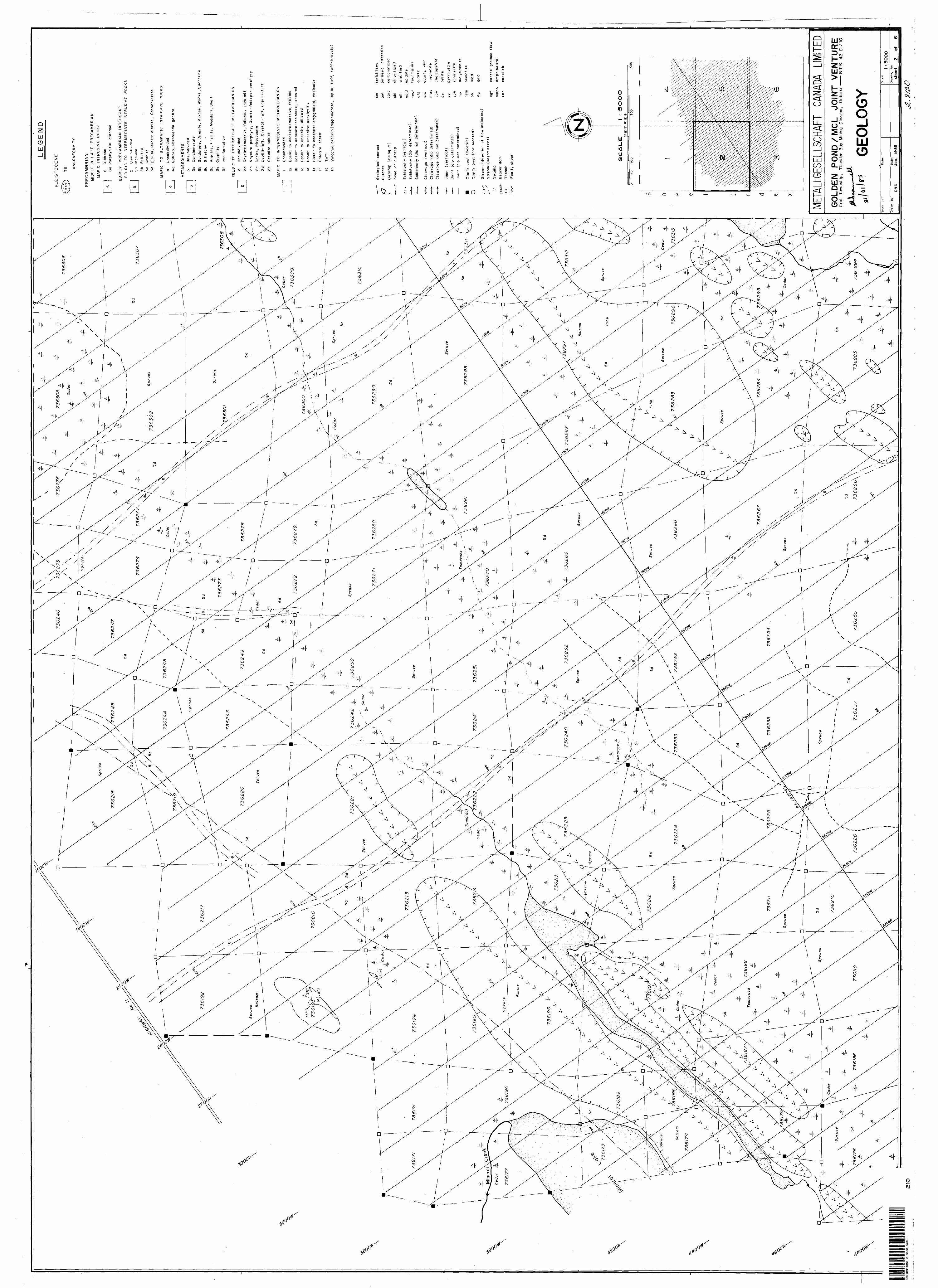
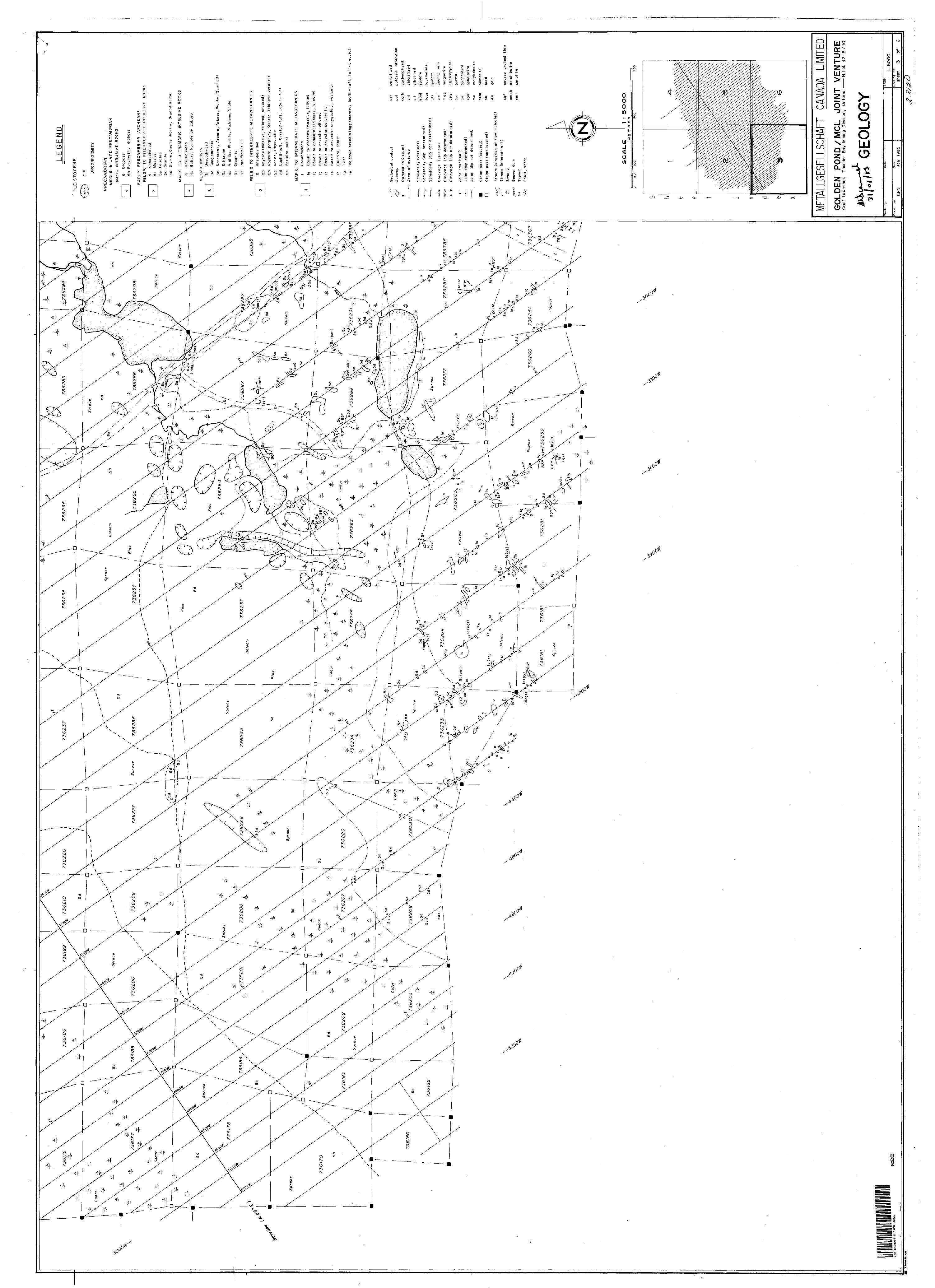
PROPERTY GEOLOGY Croll StockMetavolcanics and Metasediments Diabase Dykes
VLF-EM 16 SURVEY
CONCLUSIONS AND RECOMMENDATIONS
BIBLIOGRAPHY
APPENDIX I APPENDIX II APPENDIX III
BudgetGeology Maps l, 2 , 3Geology Maps 4, 5, 6
010C
Page
l
5
6
7
89
12131415
17
21
23
l l l l ll
l: m
l l l l l l l l l
INTRODUCTION
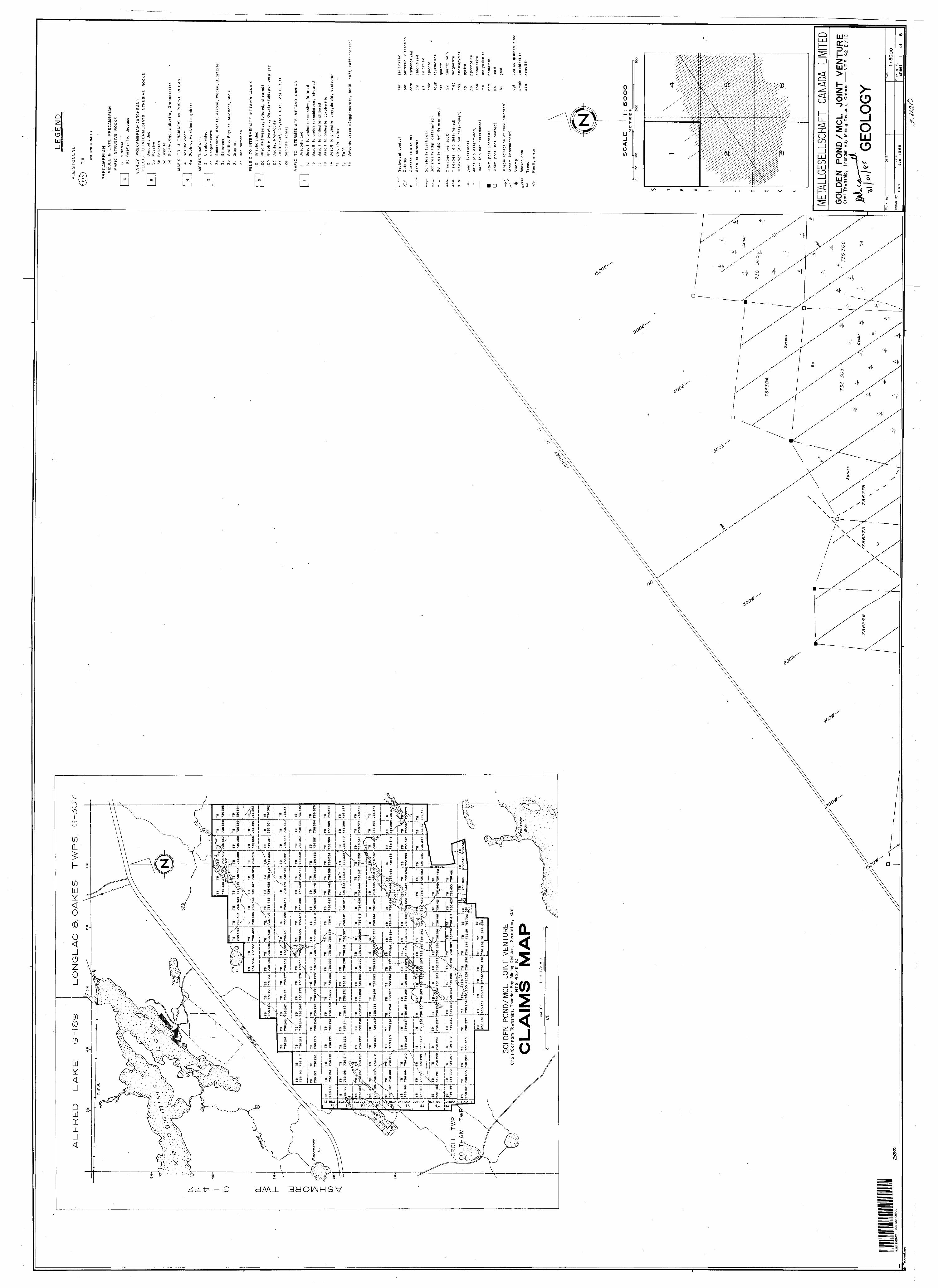
The Geraldton Project encompasses a total of 291" contiguous
claims located in Croll and Coltham Townships, near Geraldton,
Ontario (Fig. l, 2 and Appendix 2). The claim group is held jointly
between Golden Pond Resources Ltd. and Metallgesellschaft Canada
Ltd. :
Golden Pond Resources Ltd. Metallgesellschaft Canada Ltd.169 Perreault Ste. 3100, 2 Bloor St. EastVal d'Or, Quebec J9P 2H1 Toronto, Ontario M4W 1A8
The epigenetic origin of the Geraldton gold deposits is similar
to some of the deposits in the Val d'Or area of Quebec. Within the
vicinity of the Bourlamaque Batholith, gold-bearing zones of
shearing and faulting extend from the volcanics into the intrusive.
Examples of such mineralized structures are to be found in the Bra
d'Or and Belmoral Mines. Following the discovery of the Belmoral
Mine, a number of areas were explored for similar geological
environments, however, it would appear that the Croll Lake Stock was
overlooked. Therefore, the Croll Lake property was acquired by
Golden Pond and Metallgesellschaft with the intention to explore
within the stock for zones of shearing and faulting which may be
favourable hosts for gold mineralization.
- 2 -
A geophysical survey consisting of a VLF-EM 16 and magnetometer
survey was conducted early in 1984 (Scammell 1984). This was
followed by the geological mapping program described herein, which
was conducted between August 20 and September 25, 1984.
l l lmm
I The Croll claim group covers part of a northeast-trending felsic
m batholith (Croll Lake Stock) which is up to 5 km wide on the
property and has intruded predominantly mafic volcanics. Quartz
l veins with varying amounts of feldspar, chlorite, tourmaline and
' sulphide minerals are common throughout the Croll Lake Stock but are
l most frequent in the porphyritic "nose" at its west end. Sulphide
minerals of the veins there comprise pyrite, pyrrhotite,
chalcopyrite and molybdenite. Molybdenite mineralization reaches
l across the porphyritic margin of the stock into the metavolcanics to
the west.
l' Most of the economic deposits in the Geraldton area are spacially
associated with a series of east trending faults, particularly the
j Bankfield-Tombill and Little Long Lac faults.
I If these fault systems are projected eastward from Geraldton, ,,
then they should intersect the Croll Lake Stock. There is a
i considerable amount of evidence that the volcanics and sediments on
l
l
l
l
iI .
both sides of the stock have been faulted and subsequently
M mineralized with sulphides and gold (no economic deposits have been
outlined but a number of showings are known). Also, there is some
l evidence which would indicate that the stock itself has been
subjected to a similar period of faulting and possibly to
g
l
l
l
l
l
l
l
l
mineralization: the granitic stock has a tear drop shape, elongated
towards the southwest. This shape could be the result of a series
of dextral (right hand) fault movements (the Bankfield-Tombill Fault
is a dextral fault).
It is obvious that the Croll Lake Stock intruded the Beardmore-
Geraldton greenstone belt and is therefore younger than its
enveloping rock units. The stock is, however, weakly foliated and
could be contemporaneous with the mineralizing event or even older.
Based on the literature available, the sequence of events leading up
to the deposition of the gold deposits in the Geraldton area are:
1. Deposition of volcanic and sedimentary rocks
m 2 . Intrusion of the Croll Lake Stock
3. Intrusion of the porphyries
l 4. Folding major (Regional Fi)
5. Folding minor (F2)
6. Faulting, following an east-west trend parallel to the FI folding, which continues throughout and after the period of mineralization
l
l
l
l
l
l
l
l
l
l
l
l
l
l
l
- 4 -
7. Injection of auriferous solutions of at least two generations:
a) High temperature deposition characterized by the presence of tourmaline, arsenopyrite and pyrite
b) Low temperature deposition characterized by the presence of galena
lIf this sequence of events did indeed lead to the formation of
the Geraldton gold deposits, then it follows that the Croll Lake
Stock must have been subjected to the same deformation as the
surrounding volcanics and sediments. This, together with the
physical characteristics of the intrusive, should make the Croll
Lake Stock a prime target for gold exploration.
l l l l l
l l l l l l l l
- 5 -
LOCATION AND ACCESS
The claim group is located to the southeast of the No. 11 Trans
Canada Highway. Its western boundary is situated approximately 10 km
to the east of the town of Geraldton (Fig. 2).
m Although the No. 4 claim post of claim TB 736192 is conveniently
located at the side of highway 11, in general/ the majority of the
l claims are only accessible by walking or by helicopter and during
the winter also by skidoo. A number of logging roads transect the
l property as shown on the 1:50,000 topographical map (Geraldton
M 42-E-10). However, many of these roads are covered by secondary
growth, in particular tag alders, which precludes them from being
l used for access except by heavy equipment. This growth is often so
dense that it makes even walking along these trails extremely
difficult.
l l
l
- 6 -
TOPOGRAPHY AND VEGETATION
- The general physiography of the claim group reflects the
l underlying Precambrian and Pleistocene geology. The northern part of
the property is underlain by the Croll Granodiorite Intrusion. Its
P topography is characterised by one of low relief and poor drainage.
. Pleistocene glaciation from the northnortheast with its subsequent
deposition of moraines and eskers obscures the bedrock topography.
lIt has also disrupted the pre-ice drainage systems. As a
l consequence, sand and gravel deposits have imposed an alignment on
many of the swamps, creeks and lakes parallel to the ice direction.
H The logging roads are generally restricted to the glacial ridges and
B consequently these too reflect the glacial fabric of the area.
l Since the moisture content of the soil is one of the main factors
determinng the type of vegetation which grows in that area, then in
l a crude way the vegetation on the property does reflect the glacial
m morphology. The poorly drained swamp areas, interspersed around the
glacial deposits, are generally covered by two types of tree growth,
consisting either of dense cedar growth or open swamp which supports
a stunted growth of tamarack and spruce. By comparison, the sand and
l gravel deposits are well drained and support a tree population
consisting mainly of mature balsam, pine and spruce. These deposits
generally attain a maximum elevation of 15 m, above the level of the
l surrounding swamp.
l
l
l
l
l
l
l
l
ll * Basic volcanics and volcanoclastic sediments underly the
l southern part of the property. Here, at the granite/volcanic
contact, the volcanics form a steep north facing scarp which has a
l corresponding low angle dip slope to the south. It rises to a
maximum hight of 40 m above the level of the swamp. As a
" consequence, the ground is well drained and devoid of glacial
j deposits. The overburden is generally thin and supports a mature
growth of balsam, spruce, poplar and occasionally birch. The
l poplar growth is generally restricted to dip slope where the "A"
horizon is better developed and the moisture content is higher.
HISTORY BEARDMORE-GERALDTON GOLD CAMP
Gold was first discovered near Geraldton during World War I and
l in the Beardmore area in 1925. Gold finds at Lake Kenogamisis in
1931/32 led to the development of the Hard Rock, Little Long Lac and
several other mines.
lProduction from eleven bigger and eight small mines between 1934
l and 1968 totalled over 4 million ounces of gold and half a million
g ounces of silver with the major producer being MacLeod-Cockshutt
Mine near Geraldton (1.47 mio oz gold, 0.1 mio oz silver).
l
l l
- 8 -
By 1970 most of the mines were closed and it was not until 1980
H that efforts were made again by several companies to bring the camp
back to life. Among others are Mining Corporation of Canada
l Limited (Consolidated Louanna Gold Mines), Roxmark Mines Limited
and Sheritt Gordon Mines Limited (Magnet Consolidated Gold Mine),
l Pancontinental Mining (Canada) Limited and Dome Mines Limited,
m which have all explored various claim groups in the general area,
mostly looking for the traditional deposits related to oxide iron
l formations.
l
l
l
l
SURVEY PARAMETERS
Line Cutting
A 10.2 km base line was established at an azimuth of N55E and a
total of 319.4 km of grid lines were cut perpendicular to the base
H line. The spacing between consecutive lines was 150 m and stations
were established along those lines by means of a marked picket at
l 25 m intervals. The orientation of the base line was chosen on the
basis that it was generally parallel to the main structural
l features, associated with auriferous mineralization within the
Geraldton area. In addition, it is approximately parallel to the
l
l
l
l
stratigraphy of the volcanic and volcanoclastic rocks underlying
the southern part of the property.
l - 9 -
General Geology
l
l
l
l
l
l
The Geraldton area lies at the southern boundary of an
east-trending isoclinal ly folded Early Precambrian (Archean)
metavolcanic-metasedimentary sequence of the Wabigoon Subprovince.
These have been intruded by a series of felsic batholiths, stocks
and sills as well as lenticular shaped gabbros, also of Archean
l
l
l
l
l
l
l- Unconformity -
PrecambrianMiddle to Late Precambrian
l Mafic Intrusive Rocks
age. During the Late Precambrian north-trending diabase dykes were
intruded into the older formations.
The following is generalized geological succession in the
vicinity of the map area:
PhanerozoicCenozoic
Quaternary Recent
Organic swamp and aullival deposits
PleistoceneOutwash deposits and moraine (sand, gravel, clay, silt and till)
Diabase, porphyritic diabase
- Intrusive Contact -
l l l l l
l l l l l l l l l l l l l
- LO -
Early Precambrian (Archean) Felsic Intrusive Rocks
Quartz porphyry, granodiorite, quartz monzonite
- Intrusive Contact -
Intermediate to Mafic Intrusive RocksHornblende gabbro, gabbro, diorite
- Intrusive Contact -
Metavolcanics and Metasedimentsl Metasediments
Interbanded wacke and mudstone, coarse grained sandstone, conglomerate, banded metasediment or tuff
Chemical sediments, ironstone, chert, ferrugenous chert and graphitic schist
MetavolcanicsFelsic to Intermediate Metavolcanics
Tuff, lapillistone, lapilli tuff, quartz and of feldspar porphyry, felsic dykes
Intermediate to Mafic MetavolcanicsPillowed and/or amygdaloidal flows, pillow breccias, flow breccias, coarse-grained volcanic rocks, inter flow banded tuffs
Most known gold deposits of the area are spatially related to
iron formation and to east-trending fault zones, i. e. the Paint
Lake Fault, Bankfield-Tombill Fault, Little Long Lac Fault. It is
postulated that this period of folding produced zones of weakness
which failed when subjected to subsequent lateral tension. The
mineralization is not associated with anyone lithological unit and
it appears that the physical properties of the rock were more
l l l
- 11 -
important for gold deposition than its lithology. Gold
mineralization is associated with the more competent units which,
when subjugated to strain, produced zones of fracturing or
f brecciation. The fracturing provided a plumbing system for
M hydrothermal auriferous fluids. The favourable rock types in the
Geraldton camp are banded iron formation, the greywackes and the
l intrusions. Quartz is the principal gangue material filling the
fractures. The gold mineralization, in addition to quartz, is also
J associated with ankerite, tourmaline, arsenopyrite, pyrite, galena
and chalcopyrite. There is a definite relationship between the
sulphides and gold, thus there is an absence of gold in quartz that
j does not contain any sulphides. There are at least four
generations of silicification and it is postulated that gold was
l deposited in the second and third generations of quartz veining.
l
l
No evidence for a synsedimentary origin of the gold deposits has
been found so far. Field observation rather suggests a
structurally controlled, hydrothermal, epigenetic emplacement of
l gold, quartz, tourmaline and sulphide minerals in veins,
accompanied by an intense, local carbonatization of the wallrock.
l
l
l
l
l
l
l
- 12 -l l The regional metamorphic rock is greenschist in the vicinity of
* the Croll Lake property, however, it increases to lower amphibolite
l to the east. Generally, the outcrop distribution is sparce being
covered by Pleistocene sand and gravel deposits as well as more
l recent organic and alluvial deposits.
l
lPROPERTY GEOLOGY
l Approximately 801 of the claim group is underlain by the felsic
intrusive known as the Croll Lake Stock. This has been intruded
into predominantly mafic to intermediate volcanics which outcrop on
the northwest and southeast sides of the property.
l The composition of the felsic intrusive varies considerably.
Work by Dr. A. J. MacDonald of the Ontario Geological Survey over
l the last three years suggests that the intrusive is zoned with an
m equigranular granitic core being surrounded by rinds of quartz
monzonite, diorite, plagioclase-phyric diorite and quartz porphyry
(Figure 3). This sequence is best developed and exposed immedia
tely west of the property at the western tip of the intrusion
where it was studied in detail by MacDonald. Quartz with varying
amounts of feldspar, chlorite, tourmaline and sulphide mineralsM
are found throughout the Croll Lake Stock and intruded into the
l
l
l
l
l
l l l
J . metavolcanics and metasediments. However, they appear to occur
r m most frequently in the porphyritic "nose" of the intrusion. This,
l however, may be a function of the availability of outcrops rather
than an incrase in the abundance of quartz veining.
lWithin the porphyritic "nose" the quartz veins are mineralized
l" with pyrite, pyrrhotite, chalocpyrite and molybdenite. Molybdenite
B mineralization occurs also in quartz veins within the metavolcanics
that are in contact with the porphyritic stock.
lCroll Stock
The felsic intrusive underlying the Croll property varies in
composition from granodiorite to quartz monzonite. At the margins
of the intrusive where it is in contact with the metavolcanics,
l xenoliths of metavolcanic material are common. Generally, these
have been metamorphosed to amphibolite. The contact itself where
l it is exposed is sharp with little or no assimilation of the
m country rock. Occasionally, the volcanics are intruded by narrow
dykes and sills which have a similar composition to the main stock.
lThe stock is weakly foliated. However, only one area of minor
l shearing with associated alteration was located on Line 1950E at
3175S. The alteration is fairly typical consisting of quartz,
* feldspar, chlorite tourmaline and carbonate over a width of one
metre. No sulphides were observed within the zone of alteration.
lOther alteration observed within the stock was potassic
l alteration along fractures, epidotization of the feldspar
l
l
l
l
constituents and the occasional development of blue quartz eyes.
Most of this alteration appears to occur near the contacts with the
diabase dyke and was of a very localized nature.
Metavolcanics and Metasediments
l
Approximately 201 of the property is underlain by metavolcanics
l with minor metasediments. They occur on the northwestern and
southeastern boundaries of the claim group striking in a west to
northwest direction. The best exposure of these rocks is found on
B the southeastern part of the property where, as has already been
mentioned, they form a series of low hills.
lThe southern contact with the granodiorite intrusive is exposed
l in several places and appears to dip to the north. The
m metavolcanics in contact with the stock have been recrystallized
and are occasionally hornfelsic. Here the predominant rock types
l are basic to intermediate pillowed and/or amygdaloidal flows with
only minor interflow volcanoclastic tuffs and sediments. These
l flows are generally massive and exhibit little or no foliation.
M Flow breccias were observed on Line 1950W and 2100W between 3200S
and 3250S, and again on 3500W and 2500S.
l l
l
l
i l
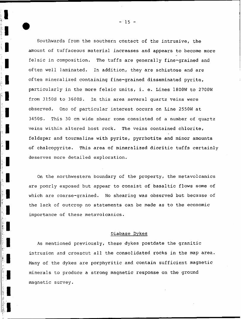
- 15 -
Southwards from the southern contact of the intrusive, the
l amount of tuffaceous material increases and appears to become more
m felsic in composition. The tuffs are generally fine-grained and
often well laminated. In addition, they are schistose and are
l often mineralized containing fine-grained disseminated pyrite,
particularly in the more felsic units, i. e. Lines 1800W to 2700W
l from 3150S to 3600S. In this area several quartz veins were
m observed. One of particular interest occurs on Line 2550W at
3450S. This 30 cm wide shear zone consisted of a number of quartz
l veins within altered host rock. The veins contained chlorite,
feldspar and tourmaline with pyrite, pyrrhotite and minor amounts
l of chalcopyrite. This area of mineralized dioritic tuffs certainly
deserves more detailed exploration.
l On the northwestern boundary of the property, the metavolcanics
are poorly exposed but appear to consist of basaltic flows some of
P which are coarse-grained. No shearing was observed but because of
the lack of outcrop no statements can be made as to the economic
importance of these metavolcanics.
Diabase Dykes
l As mentioned previously, these dykes postdate the granitic
intrusion and crosscut all the consolidated rocks in the map area.
* Many of the dykes are porphyritic and contain sufficient magnetic
l minerals to produce a strong magnetic response on the ground
magnetic survey.
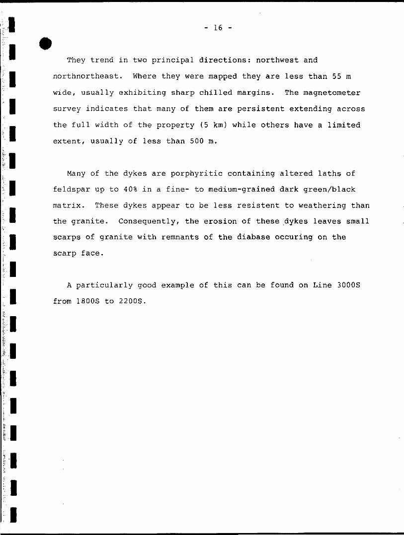
l They trend in two principal directions: northwest and
l northnortheast. Where they were mapped they are less than 55 m
wide, usually exhibiting sharp chilled margins. The magnetometer
l survey indicates that many of them are persistent extending across
the full width of the property (5 km) while others have a limited
* extent, usually of less than 500 m.
lMany of the dykes are porphyritic containing altered laths of
l feldspar up to 40?, in a fine- to medium-grained dark green/black
matrix. These dykes appear to be less resistent to weathering than
B the granite. Consequently, the erosion of these dykes leaves small
M scarps of granite with remnants of the diabase occuring on the
scarp face.
lA particularly good example of this can be found on Line 3000S
l
l
l
l
l
l
l
l
from 1800S to 2200S.
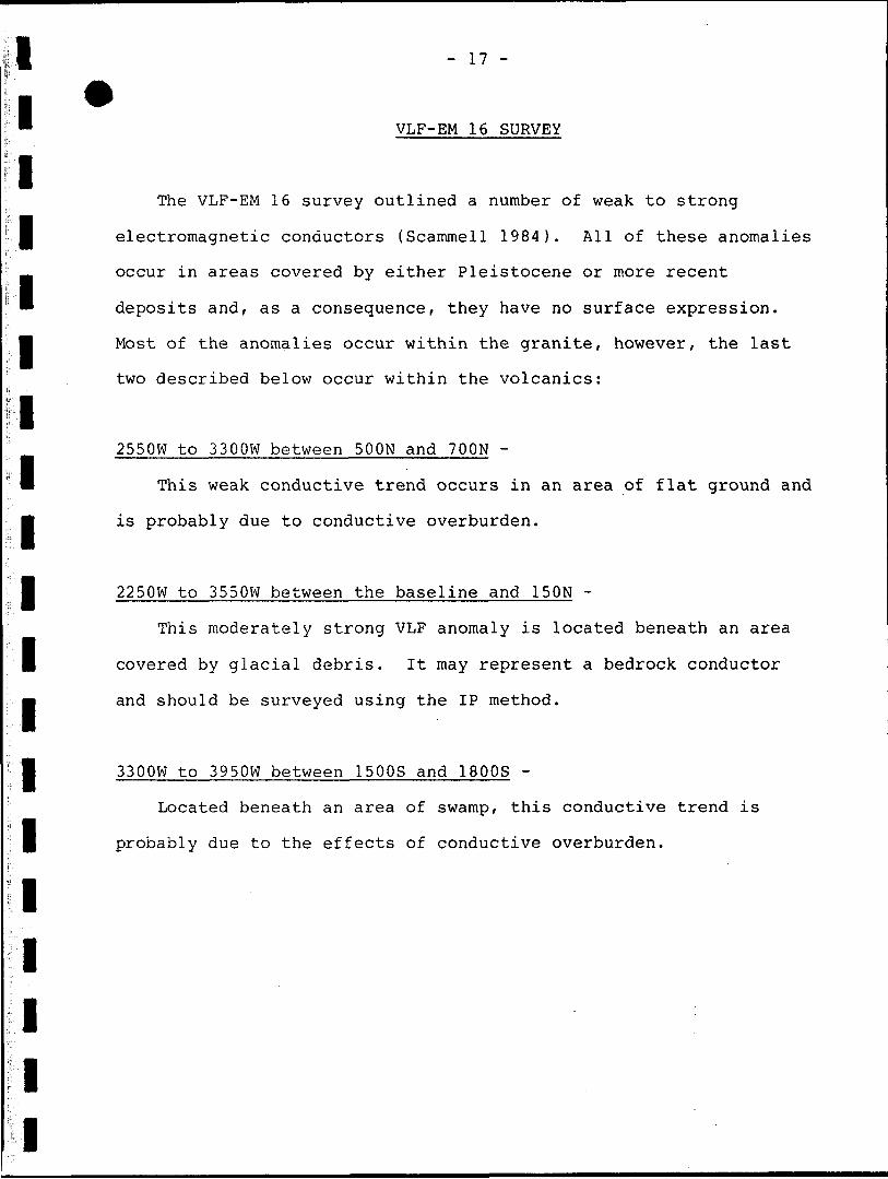
l" VLF-EM 16 SURVEY
lThe VLF-EM 16 survey outlined a number of weak to strong
l electromagnetic conductors (Scammell 1984). All of these anomalies
occur in areas covered by either Pleistocene or more recent
* deposits and, as a consequence, they have no surface expression.
j Most of the anomalies occur within the granite, however, the last
l
l
l
l
l
l
l
l
l
l
l
l
two described below occur within the volcanics:
2550W to 3300W between SOON and 700N -
This weak conductive trend occurs in an area of flat ground and
is probably due to conductive overburden.
2250W to 3550W between the baseline and 150N -
This moderately strong VLF anomaly is located beneath an area
covered by glacial debris. It may represent a bedrock conductor
and should be surveyed using the IP method.
3300W to 3950W between 1500S and 1800S -
Located beneath an area of swamp, this conductive trend is
probably due to the effects of conductive overburden.
i l i
i
i i i i
- 18 -
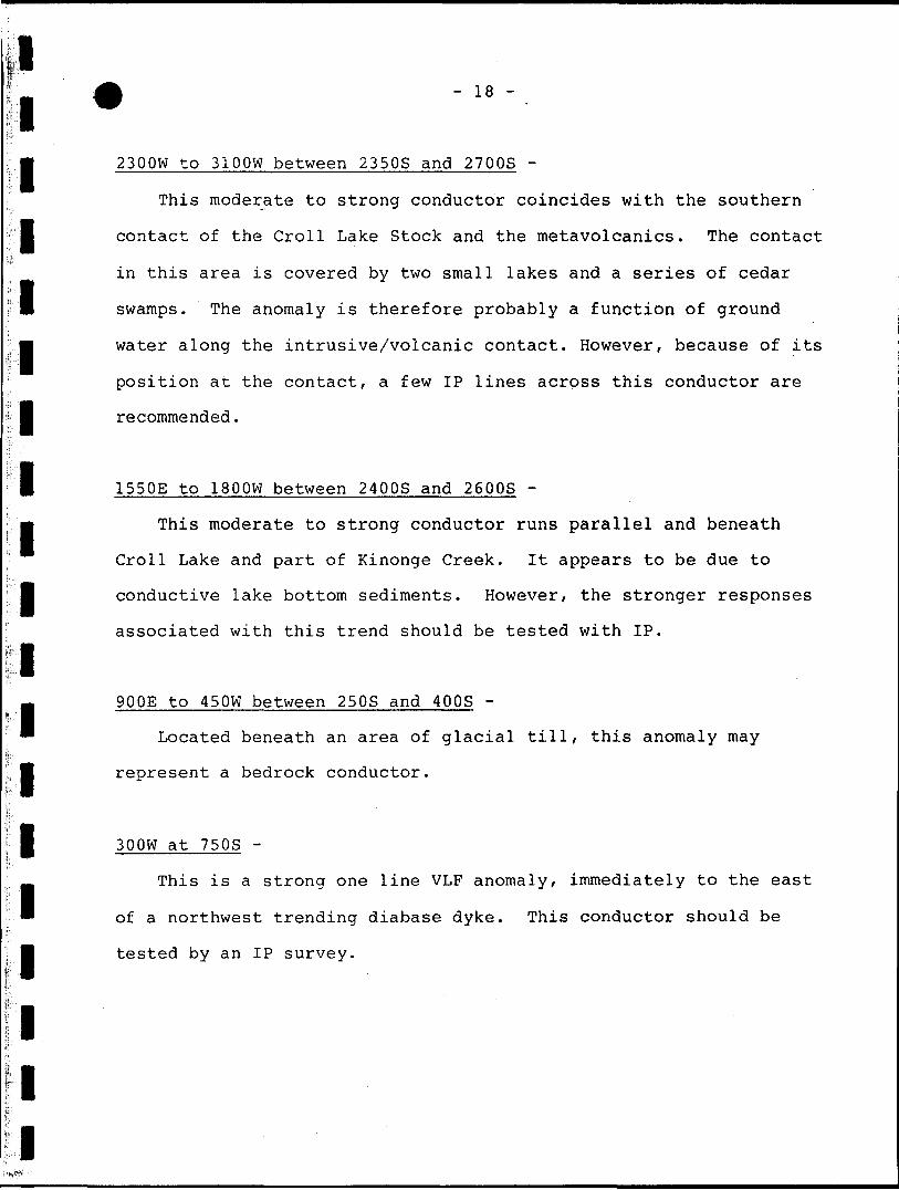
2300W to 3100W between 2350S and 2700S -
This moderate to strong conductor coincides with the southern
l contact of the Croll Lake Stock and the metavolcanics. The contact
in this area is covered by two small lakes and a series of cedar
l swamps. The anomaly is therefore probably a function of ground
m water along the intrusive/volcanic contact. However, because of its
position at the contact, a few IP lines across this conductor are
l recommended.
1550E to 1800W between 2400S and 2600S -
m This moderate to strong conductor runs parallel and beneath
Croll Lake and part of Kinonge Creek. It appears to be due to
l conductive lake bottom sediments. However, the stronger responses
associated with this trend should be tested with IP.
lm 9 00E to 450W between 250S and 400S -
Located beneath an area of glacial till, this anomaly may
l represent a bedrock conductor.
300W at 750S -l This is a strong one line VLF anomaly, immediately to the east
of a northwest trending diabase dyke. This conductor should be
tested by an IP survey.
l l l l l l
- 19 -
1150E to 4050E between 150S and 1000S -
There are a number of weak to moderate VLF conductors occuring
in this area. Many are located beneath areas of wet cedar swamp
between areas of granodiorite outcrop. It would appear that they
are due to conductive overburden, however, selective anomalies
could be tested with IP.
950E to 1550E between 400S and 450S -
l This medium to strong conductor is located beneath an area of
swamp and may represent conductive overburden.
m 1 800E to 3600E between 1150S and 1450S -
This trend consists of two enechelon VLF conductors occuring
l beneath an area of swamp between two areas of granodiorite
l
l
l
l
l
l
l
l
l
outcrop. In all probability, these represent conductive
overburden, however, the stronger part of the trend should be
tested with IP.
1550E to 2150E between 3500S and 3600S -
This strongly conductive zone appears to be related to the
bedrock and should be tested with IP.
l l
l l
- 20 -
1450E to 1900E between 3800S and 3850S -
l This weak conductor is located beneath Jackfish Bay and appears
to be related to conductive lake bottom sediments.
l 2050W to 2600W between 3650S and 3700S -
This weak VLF anomaly occurs near the southern boundary of the
l property where the metavolcanic/metasediment outcrop dips beneath a
cedar swamp. It therefore probably represents conductive
l overburden.
1600W to 1850W between 3200S and 3250S -
This weak VLF conductor is located within the metavolcanics and
probably represents a bedrock conductor.
l
l
l
l
l
l
l
i i i
l l l
l l l l l l l l l l
- 21 -
CONCLUSIONS AND RECOMMENDATIONS
l The potential for epigenetic gold deposits hosted by Croll Lake
Stock still exists. However, the overburden cover, particularly on
l those claims underlain by the intrusive, has made it impossible to
identify potential zones of shearing and faulting. These by their
very nature would be less resistent to glacial erosion than the
M surrounding rock. Consequently, they would be restricted to the
lower areas now covered by swamp. There are a number of these
l areas as shown on the geological map which are generally aligned
parallel to the ice direction. Many,of these correspond to weak to
strong conductive trends.
The VLF-EM 16 survey, while it has identified these trends,
does not indicate whether these responses are due to conductive
overburden or conductivity associated with bedrock features. It is
therefore recommended that the stronger VLF-EM 16 anomalies be
surveyed using the Induced Polarization (IP) method. Much of the
gold mineralization in the Geraldton area is associated with only
minor sulphide mineralization. In this regard, the IP unit is
particularly useful since it responds to zones of weak
mineralization where the conducitivity is low. Once this IP survey
has been completed, and favourable zones been delineated then an
effective drilling program can be mounted.
l
l
l l l l l l
i
- 22 -
lM The outcrop density is much greater over the metavolcanics than
over the intrusive. In addition, there is only a thin overburden
l cover. Consequently, the area is a suitable one for a soil
geochemistry survey. A number of interesting prospects have been
l identified by the geological mapping and it is therefore
recommended that a soil sampling program be conducted over the more
favourable area. This area would be from L O to L 3600W between
l 2800S and the southern boundary of the property. Once completed,
areas of anomalous gold values could be trenched and if necessary,
l be investigated by diamond drilling.
l l l l l l l l l l l l l l l l l l l
- 23 -
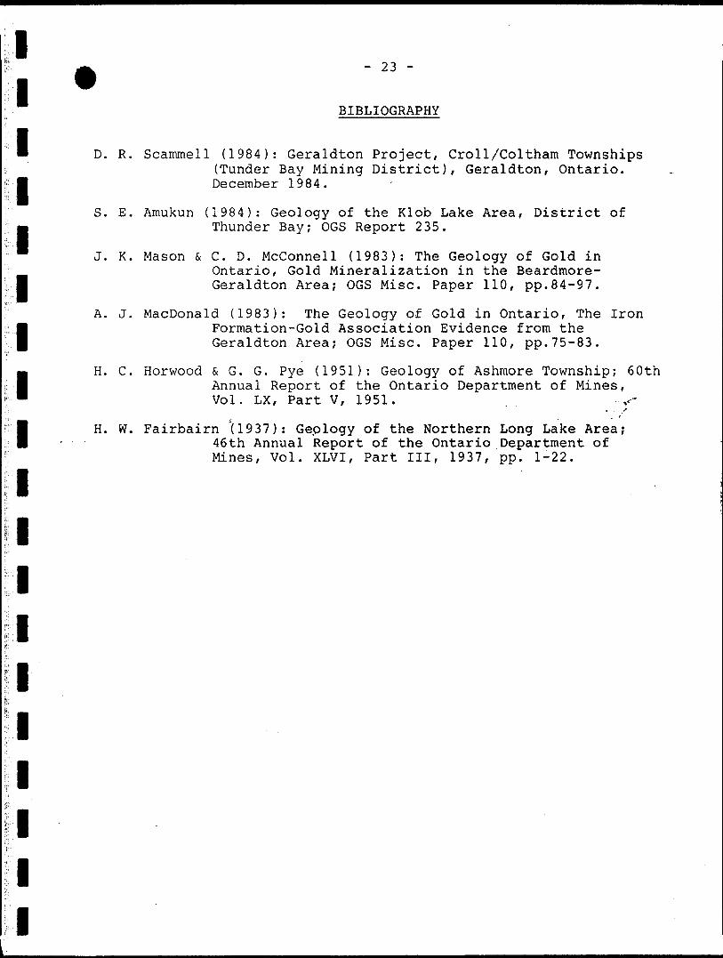
BIBLIOGRAPHY
D. R. Scammell (1984): Geraldton Project, Croll/Coltham Townships (Tunder Bay Mining District), Geraldton, Ontario. December 1984.
S. E. Amukun (1984): Geology of the Klob Lake Area, District of Thunder Bay; OGS Report 235.
J. K. Mason 6 C. D. Mcconnell (1983): The Geology of Gold in Ontario, Gold Mineralization in the Beardmore- Geraldton Area; OGS Misc. Paper 110, pp.84-97.
A. J. MacDonald (1983): The Geology of Gold in Ontario, The Iron Formation-Gold Association Evidence from the Geraldton Area; OGS Misc. Paper 110, pp.75-83.
H. C. Horwood fc G. G. Pye (1951): Geology of Ashmore Township; 60th Annual Report of the Ontario Department of Mines, Vol. LX, Part V, 1951.
H. W. Fairbairn '(1937): Geplogy of the Northern Long Lake Area; 46th Annual Report of the Ontario Department of Mines, Vol. XLVI, Part III, 1937, pp. 1-22.
1l11111111111111111
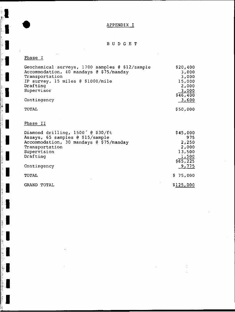
^ APPENDIX I
BUDGET
Phase I
Geochemical surveys, 1700 samples @ 512/sampleAccommodation, 40 mandays @ 575/mandayTransportationIP survey, 15 miles @ 51000/mileDraftingSupervisor
Contingency
TOTAL
Phase II
Diamond drilling, 1500' @ 530/ftAssays, 65 samples @ 515/sample Accommodation, 30 mandays @ 575/mandayTransportationSupervision Drafting
Contingency
TOTAL
GRAND TOTAL
'
520,4003,0003,00015,0002,0003,000
546,4003,600
550,000
545,000975
2,2502,00013,500 1,500
565,2259,775
5 75,000
5125,000
V)
Ontario
Ministry of Natural Resources
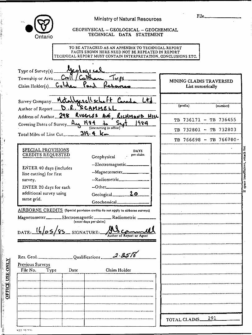
GEOPHYSICAL - GEOLOGICAL - GEOCHEMICAL TECHNICAL DATA STATEMENT
File.
TO BE ATTACHED AS AN APPENDIX TO TECHNICAL REPORTFACTS SHOWN HERE NEED NOT BE REPEATED IN REPORT
TECHNICAL REPORT MUST CONTAIN INTERPRETATION, CONCLUSIONS ETC.
Type of Survey(s)
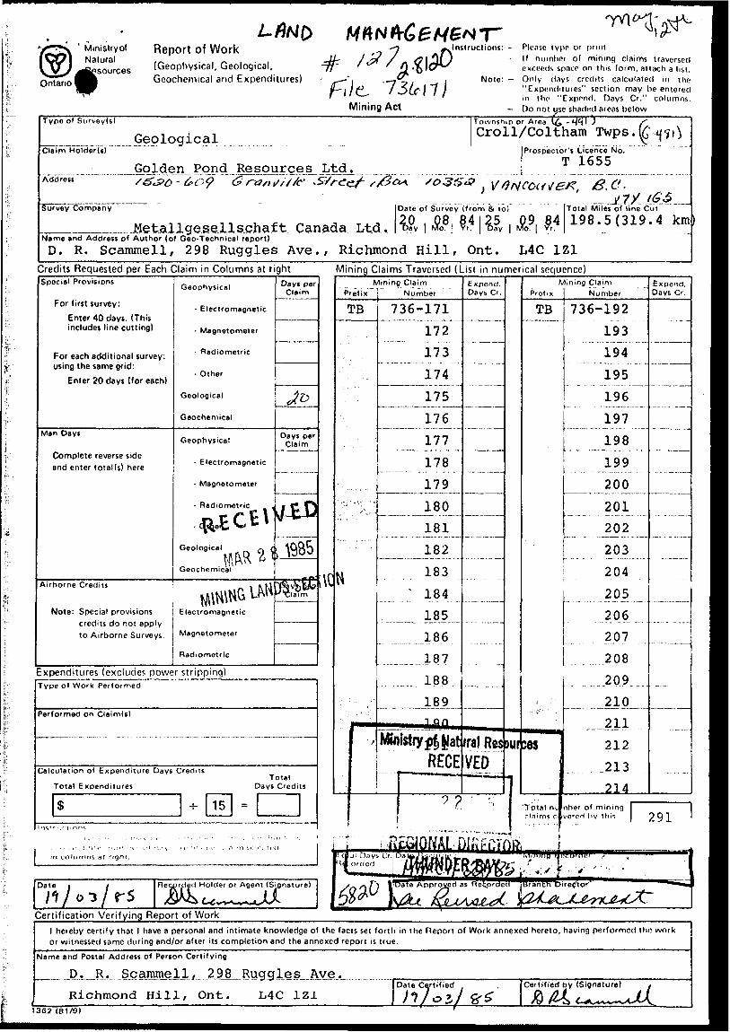
Township or Area
Claim Holder(
J^
Survey Company
Author of Report
Address of Author 2So
b. (L. SCAKK&LL
} IttrtHfriJb MmCovering Dates of Survey_
Total Miles of Line Cut
(linecutting to office)
SPECIAL PROVISIONS CREDITS REQUESTED
ENTER 40 days (includes line cutting) for first survey.
ENTER 20 days for each additional survey using same grid.
Geophysical
Electromagnetic.
DAYS per claim
-Other.
Geological. Lo
AIRBORNE CREDITS (Special provision credit! do not apply to airborne mrvcyi)
Magnetometer. .Electromagnetic.
DATE:.
(enter days per claim)
SIGNATURE:.Author of Report or Agent
Res. Geol. .Qualifications.
Previous Surveys File No. Type Date Claim Holder
MINING CLAIMS TRAVERSED List numerically
(prefix) (number)
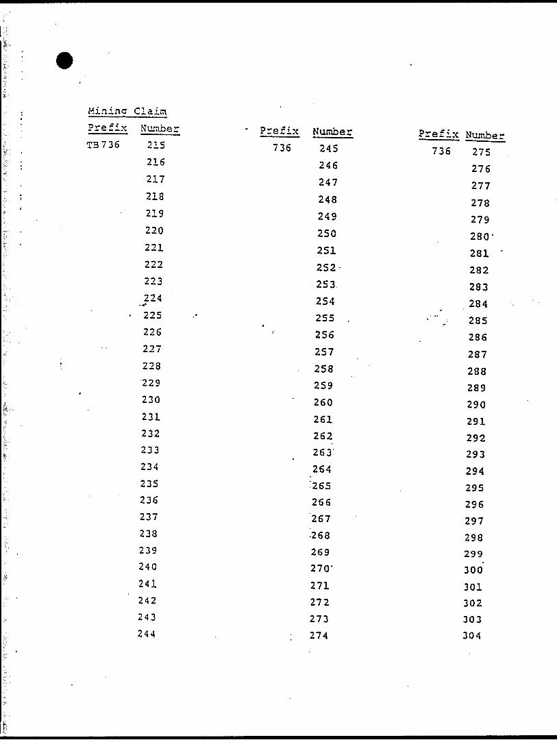
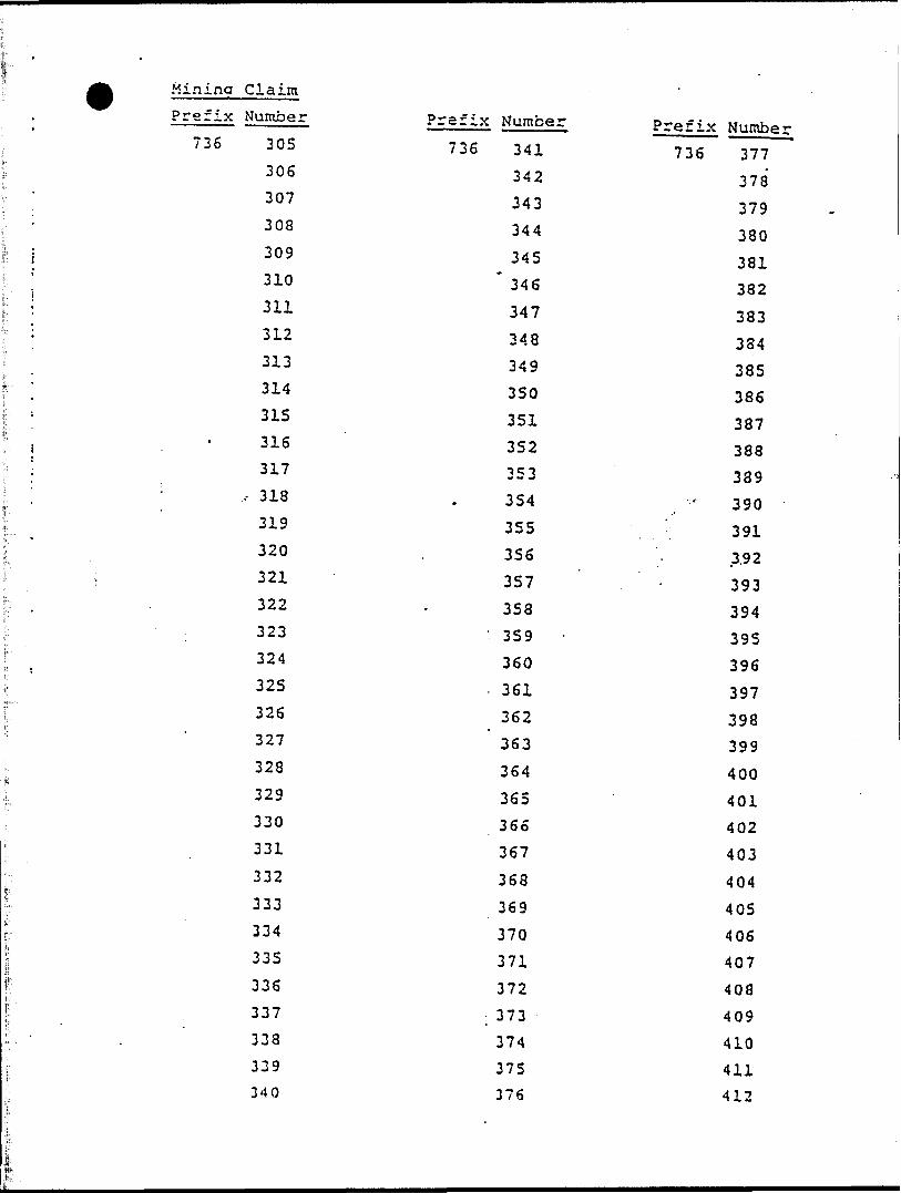
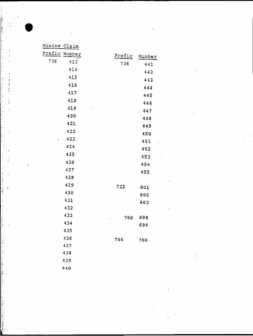
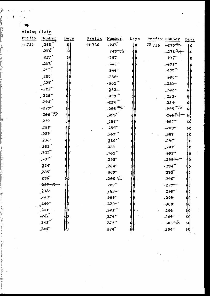
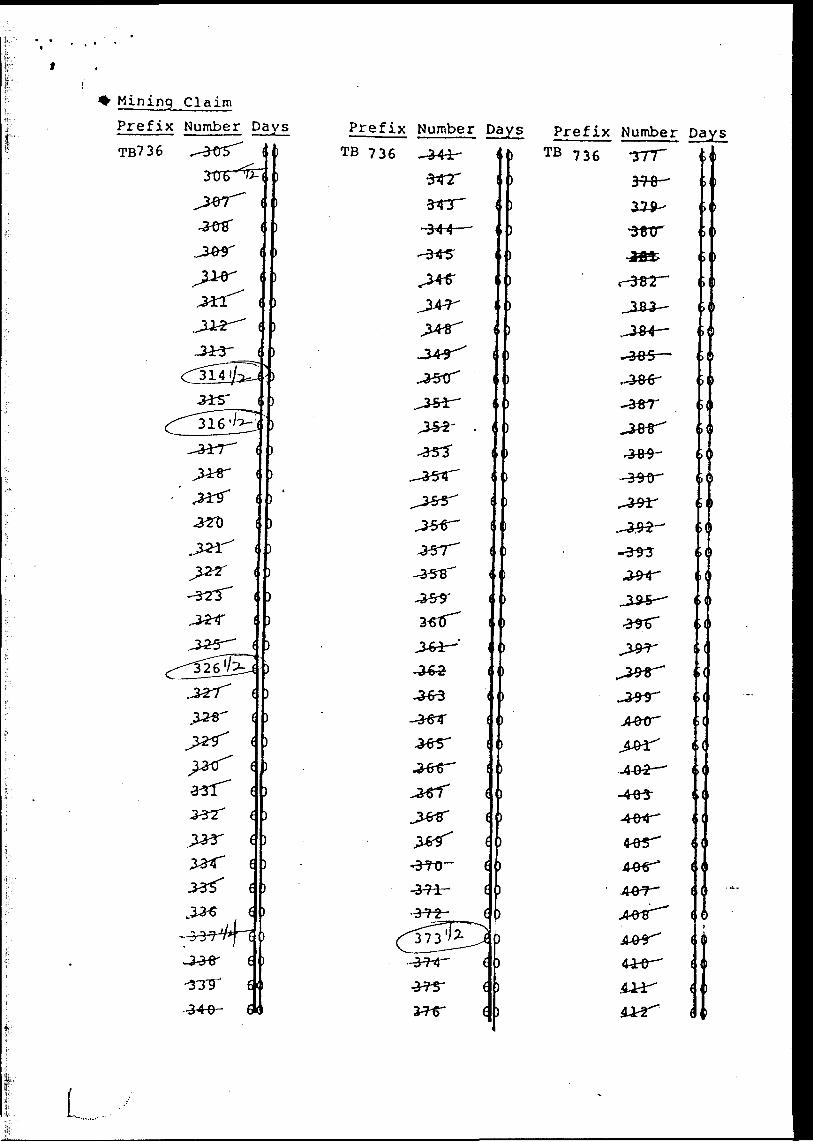
TB 736171 - TB 736455
TB 732801 - TB 732803
TB 766698 - TB 766700-
l I8Q,
291
9*37 "
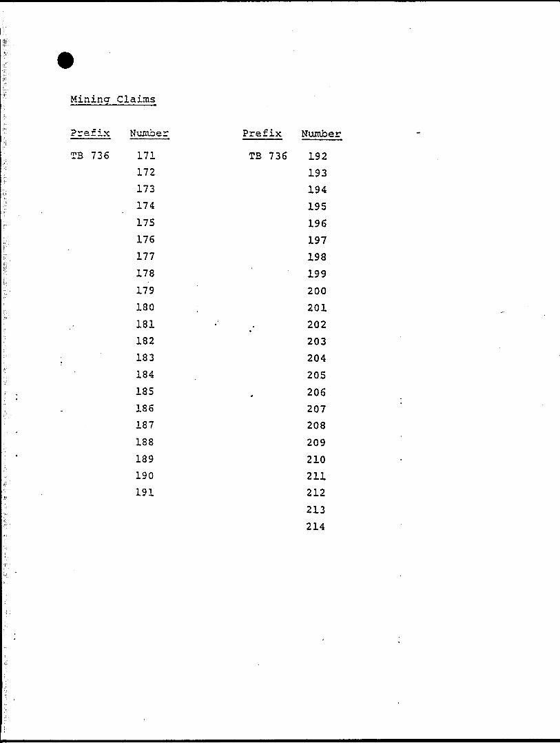
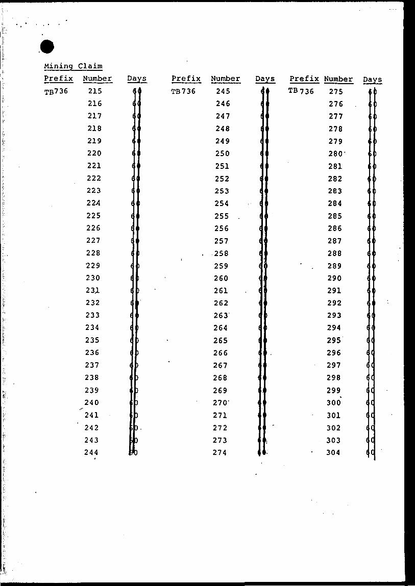
Mining Claims
Prefix Number Prefix Number
TB 736 171 TB 736 192
172 193173 194
174 195
175 196
176 197
177 198
178 199
179 200
180 201
181 - . 202182 203
183 204
184 . 205
185 . 206186 207
187 208
188 209
189 210
190 211
191 212
213
214
Mining Claim Prefix Number
T3736 21S
216
217
218
219
220
221
222
223
224•••f- 225
226
227
228
229
230
231
232
233
234
235
236
237
238
239
240
241
242
243
244
Prefix Number
736 245
246
247
248
249250
251252-
253.
254255 .
256
257
258
259260
261
262263264
^265
266
267
^268
269 270-
271272273
; 274
Prefix Number
736 275 .
276
277
278
279 280-
281 '
282
283
284.i-
- " ,, 285
286
287
288
289
290
291
292
293
294
295
296
297
298
299
300
301
302
303
304
TTt-91C
SAC
OK
6CE
8CC
CiC
BO*
sot*
TieOZ.C
69C
sec
S9C
66C
96C
S6C
T9C
09C
6SC
8SC
isc9SC
ESC
2SE
iseSK
sse
oie
osesoe
8iC
LLlgoe soe
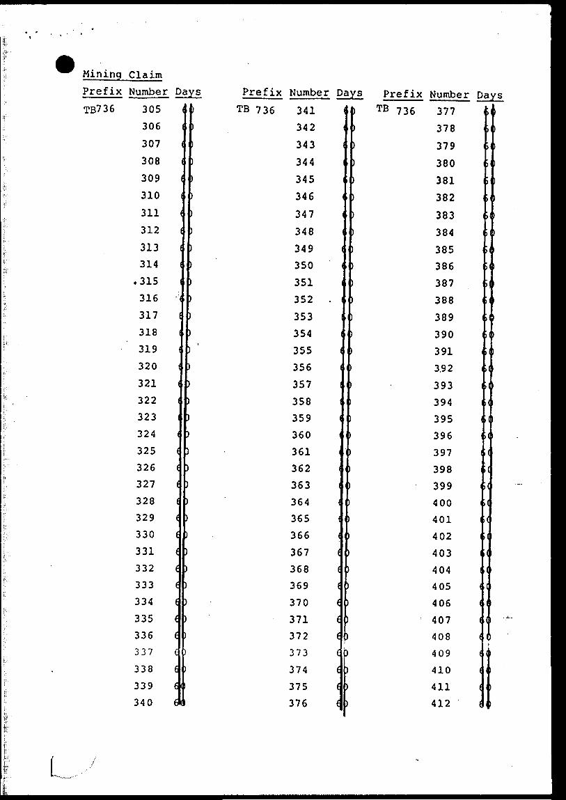
Mining Claim
Prefix Number o-0 ^ v-^ "™ "' -- 1 " i * ^ *. w ~ -.A
736 41-3' 7 36
414 rf,,44241 5
. 443416 x^^444417 A Att445418 A AC446419 447
- 420 448
421 449
422 450
' 4 23 451
424
425
426
427
428
732 .801430
431 803432
433 . 766 698434 699435
436 766 700437
438
439
440
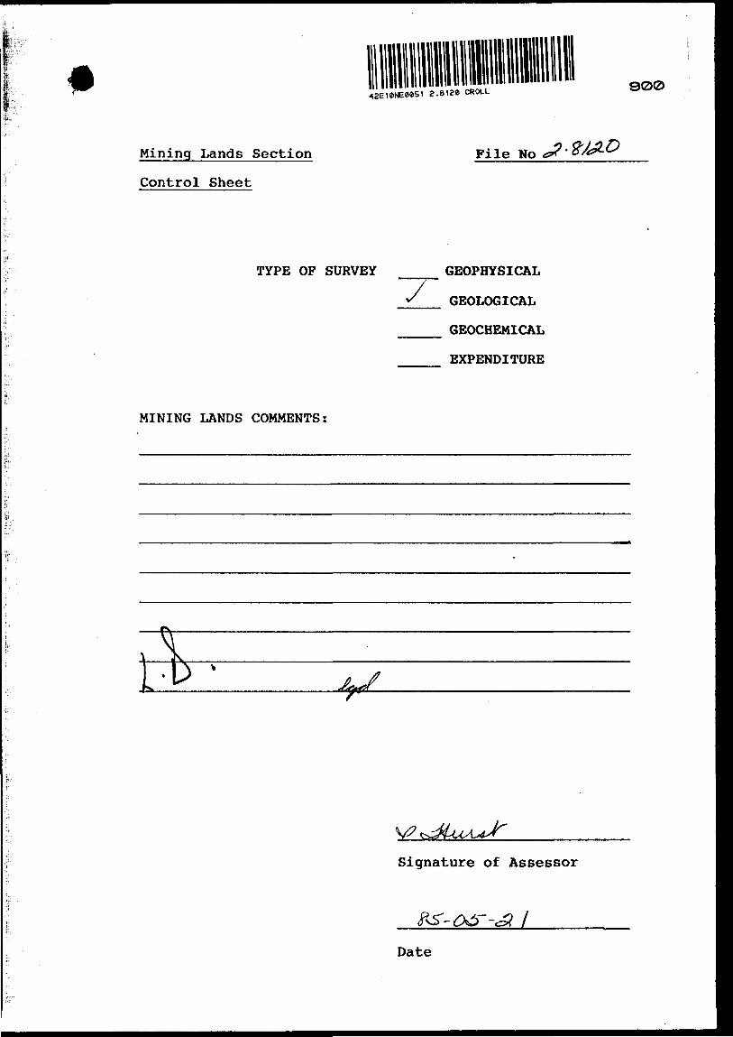
a. e i aa CROLL 900
Mining Lands Section
Control Sheet
Pile No
TYPE OF SURVEY GEOPHYSICAL
GEOLOGICAL
GEOCHEMICAL
EXPENDITURE
MINING LANDS COMMENTS:
tfc
Signature of Assessor
l
Date
* Minislryol Natural
'sourcesOntario
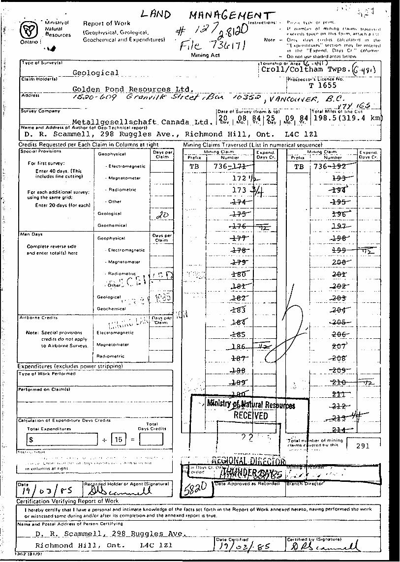
Report of Work(Geophysical, Geological, Geochemical and Expenditures)
Mining Act
Instructions: - Pleose type 01 print.II number of mining claims traversed exceeds space on this form, attach a l ist.
Note: - Only days credits calculated in the "Expenditures" section may he entered in the "Expend. Days Cr." columns.
— Do not use shaded areas below.Type of SiKvey(s)
Claim Holder(t)Geological
Township or Area (^ -*WI J f
Croll/Coltham Twps.K'-
Golden Pond Resources Ltd.Prospector's Licence No.
T 1655Address , B,C-Survey Company
JMetallge.sells.ahaft. Canada Ltd,Date of Survey (from S to) Total Miles of line Cut
198.5(319.4 kmName and Address of Author (of Oeo-Technical report)
D. R. Scammell, 298 Ruggles Ave., Richmond Hill, Ont. L4C 1Z1Credits Requested per Each Claim in Columns at rightSpecial Provisions
For first survey:
Enter 40 days. (This includes line cutting)
For each additional survey: using the same grid:
Enter 20 days (for each)
Man Days
Complete reverse side and enter total(s) here
Geophysical
- Electromagnetic
- Magnetometer
- Radiometric
- Other
Geological
Geochemical
Geophysical
- Electromagnetic
- Magnetometer
- Radiometric
Geological
Geochemica'l
Airborne Credits
Note: Special provisions j Electromagnetic credits do not applyto Airborne Surveys. Magnetometer
Radiometric
Mining Claims Traversed (List in numerical sequence)Days per,
Claim
Days per Claim
i
Expenditures (excludes power stripping)Type of Work Performed
Performed on Claim(s)
Calculation of Expenditure Days Credits
Total ExpendituresTotal
Days Credits
\(
Mining ClaimPrefix
TB
W
MM
Number
736-171
172
173
174
175
176
177
178
179
180
181
182
183
* 184
185
.. —......1.86 . ..-...—.187
——.....188...
—— 11 n il flfl...Ministry pf^at
REC'E
Expend. Days C'.
—— —— —
—— — ——
... ... ...
•MHMH
Jra! RwVEO
•MM
Dur
N Prefix
TB
•MMMU
ces
"Total nt. claims c
'
lining Claim Number
••-
736-192
193
194
195
196
197
198
t 199
200
201
202
203
204
205
— -
206
207
208
20?
211
212
213
214nber of mining vcroH lw thi*.
—— .
Expend. Days Cr.
— —- —
-------
— —— - ——
291
in columns at right.
Date i l
/1/0-3/rSRecorded Holder or Agent (Signature)
Certification Ver i tying Report of Work1 hereby certify that 1 have a personal and intimate knowledge of the facts set forth in the Report of Work annexed hereto, having performed the work or witnessed same during and/or after its completion and the annexed report is true.
Name and Postal Address of Person Certifying
D. R. Scammell, 298Richmond Hill, Ont.
Rucfcrles Ave.Date Certified
L4C 1Z1 'V 05/Certified by (Signature) i
f O ^ /W f^** CA^w^-r^C-^V.13G2 f81/9)
Mining ClaimPrefix Number Days Prefix Number Days Prefix Number DaysTB736 215 1
216 (
217 (
218 (
219 (
220 *
221 (
222 (
223 (
224 (
225 (
226 (
227 (
228 i
229 (230 (
23JL (232 (
233 i
234 (
235 (
236 (
f TB736 245 1
( 246 (
247 (
1 248 l
249 (
250 *
251 *252 1253 (
l 254 (
255 . (256 (
1 257 ( . 258 (
) 259 (l 260 () 261 . (
262 *i 263 *i 264 (b 265 (b 266 (
237 j b ' 267 1
238 (
239240'241
) 268 1) 269) 270-D 271 i
242 It. 272 i
243 E|O 273 i
244 H) 274 lt
TB736 275276 .277278279280-
281282 1283 1284285 1286 1287 ( 288 1
' . 289 (290 (291 (292 f
l 293 (l 294 (1 295 (
296 (297 *298 t299 (300 (301 (302 (
i 303 (304 (
f
J
1lli
'
Mining Claim
Prefix Number Days Prefix Number Days Prefix Number DavsTB736 305
306307308 l309 *310 (311 i312 (
313 ( 314 f
.315 1
316 (
317 f
318 (
319 1
320 (
321 (
322 (
323 (
324 (
325 f
326 (
327 (
328 (
329 (
330 (
331 (332 f
333 C
334 (
335 (
336 e337 f
338 6
339 6
340 6
I TB 736 341342 1
343 (
344) 345) 346) 347) 348) 349 ( ) 350) 351) 352 . l) 353) 354) ' 355 () 356 1
) 357 (
) 358
) 359 1
) 360
) 361) 362
) 363 1) 364 {
) 365 (
) 366 1
) 367 (
) 368 f369 (
370 (
371 (372 C
373 t
374 (
375 t
376 *
l TB 736 377) 378
) 379) 380) 381) 382
) 383) 384
1 385 386
) 387) 388
389) 3901 391i 3.921 393i 394) 395l 396) 397 1
1 398 i
) 399 il 400 i1 401 1
) 402 l
) 403 1) 404 1) 405 (
) 406 (
407 (
408 (
409 (
410 (
411 (
412 (
i* i
i
i
1
l

Mining Claim
Prefix Number Days Prefix NumberTB 736 413
414
415 (416
417
418 i
419
420
421
422 i
t l TB 736 441
442
( 443(j 444
Q 445
| 446
j 447
| 448
| 449
J 450
423 J! 451424 i \ 4 52425 (
426 (
427 (
428 i (
429 f
430 1
453454'455 X
732 801
f 802431 Jf 803432 l \
433
434 i (
435 ( (436 i (437 1 (
438 l C
439 Jc
440 1C
- -. 766 698699
766 700
Ministry ofNaturalResources
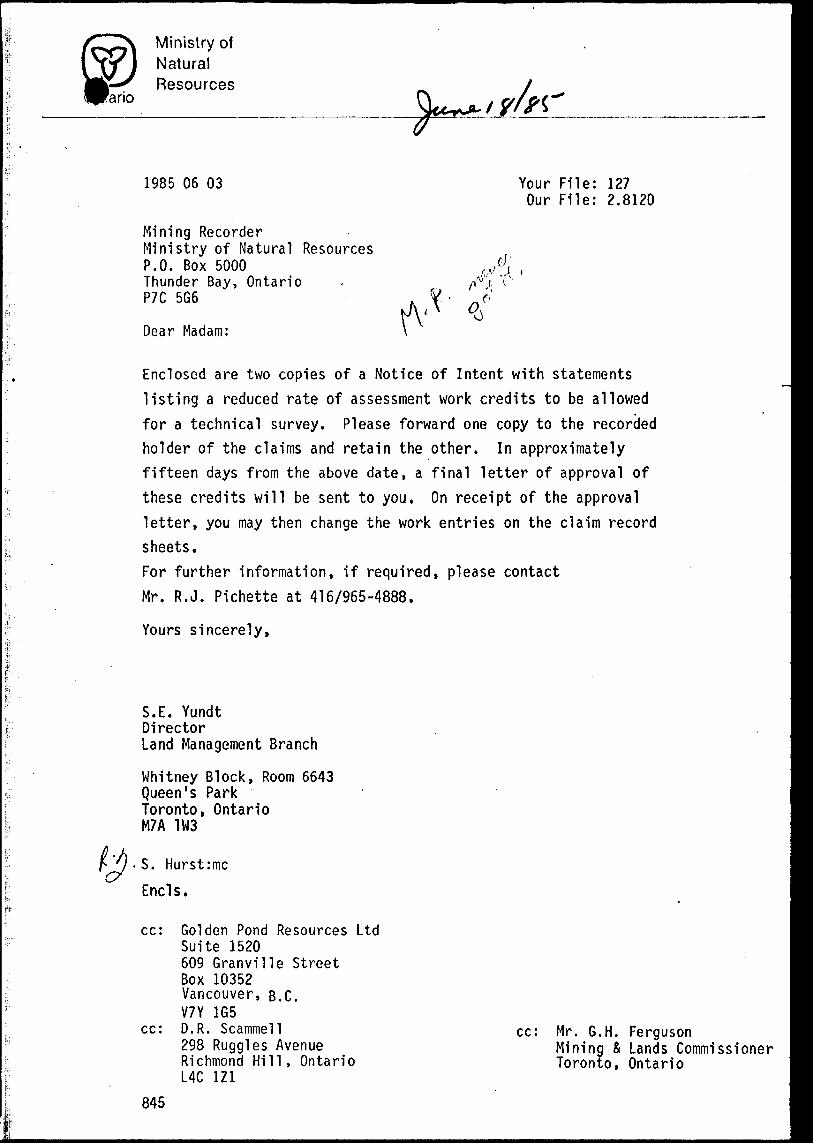
ano
1985 06 03
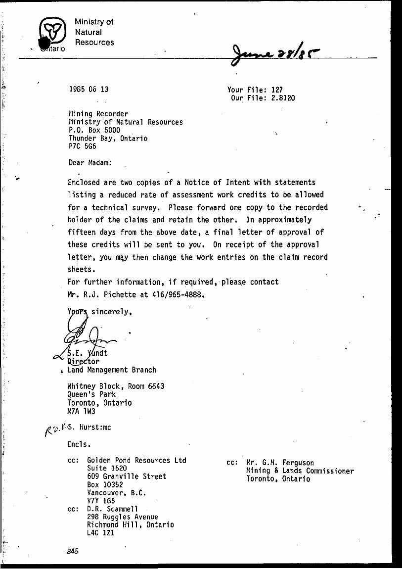
Mining RecorderMinistry of Natural ResourcesP.O. Box 5000Thunder Bay, OntarioP7C 5G6
Dear Madam:
Your File: 127 Our File: 2.8120
f
Enclosed are two copies of a Notice of Intent with statements listing a reduced rate of assessment work credits to be allowed for a technical survey. Please forward one copy to the recorded holder of the claims and retain the other. In approximately fifteen days from the above date, a final letter of approval of these credits will be sent to you. On receipt of the approval letter, you may then change the work entries on the claim record sheets.For further information, if required, please contact Mr. R.J. Pichette at 416/965-4888.
Yours sincerely,
S.E. YundtDirectorLand Management Branch
Whitney Block, Room 6643 Queen's Park Toronto, Ontario M7A 1W3
S. Hurst:mc
Ends.
cc:
cc:
845
Golden Pond Resources LtdSuite 1520609 Granville StreetBox 10352Vancouver, B.C.V7Y 1G5D.R. Scammell298 Ruggles AvenueRichmond Hill, OntarioL4C 1Z1
cc: Mr. G.H. FergusonMining X Lands Commissioner Toronto, Ontario
Ministry ofNaturalResources
Ontario
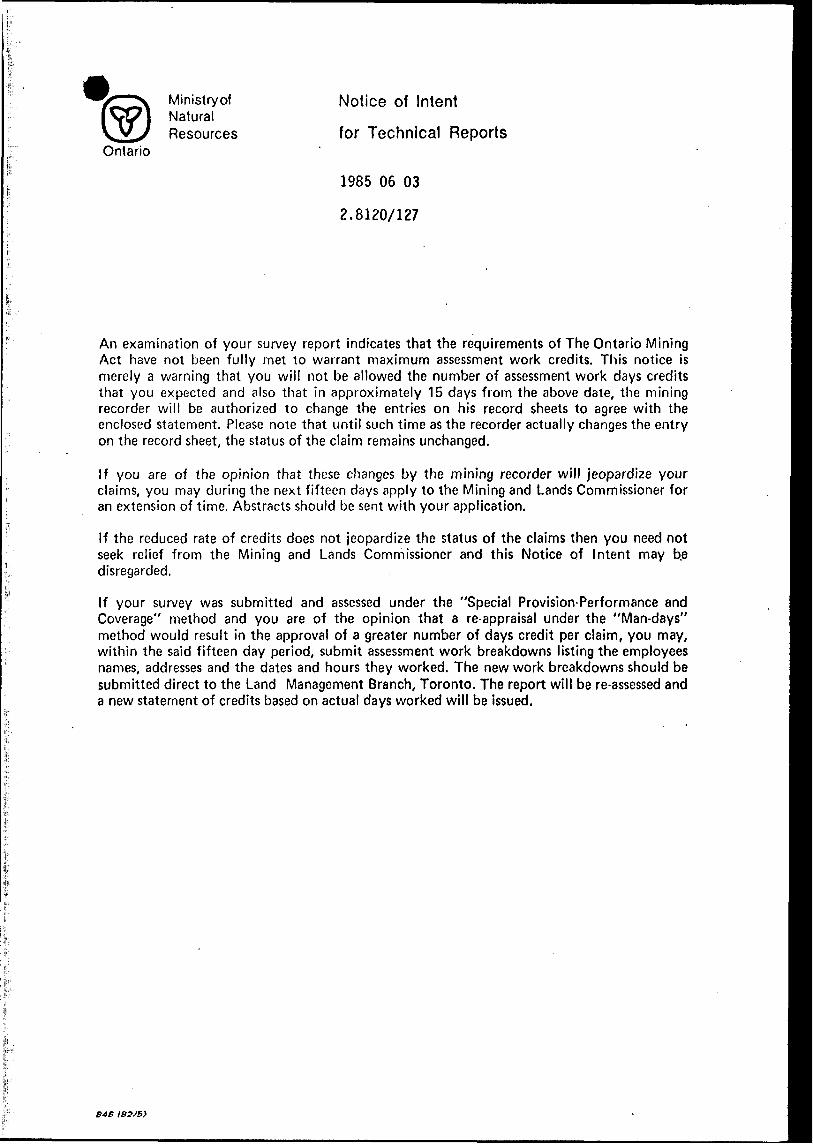
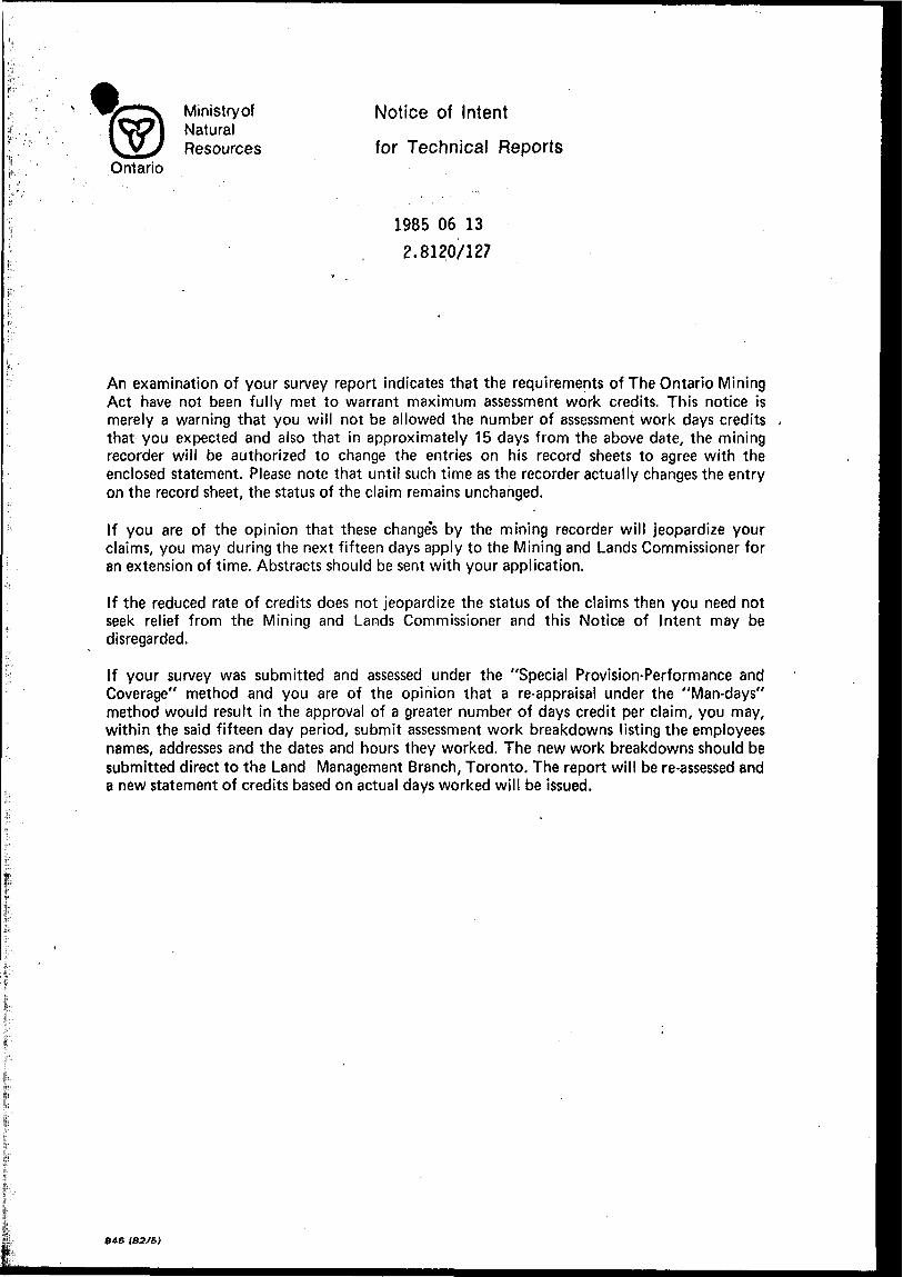
Notice of Intent
for Technical Reports
1985 06 03
2.8120/127
An examination of your survey report indicates that the requirements of The Ontario Mining Act have not been fully met to warrant maximum assessment work credits. This notice is merely a warning that you will not be allowed the number of assessment work days credits that you expected and also that in approximately 15 days from the above date, the mining recorder will be authorized to change the entries on his record sheets to agree with the enclosed statement. Please note that until such time as the recorder actually changes the entry on the record sheet, the status of the claim remains unchanged.
If you are of the opinion that these changes by the mining recorder will jeopardize your claims, you may during the next fifteen days apply to the Mining and Lands Commissioner for an extension of time. Abstracts should be sent with your application.
If the reduced rate of credits does not jeopardize the status of the claims then you need not seek relief from the Mining and Lands Commissioner and this Notice of Intent may be disregarded.
If your survey was submitted and assessed under the "Special Provision-Performance and Coverage" method and you are of the opinion that a re-appraisal under the "Man-days" method would result in the approval of a greater number of days credit per claim, you may, within the said fifteen day period, submit assessment work breakdowns listing the employees names, addresses and the dates and hours they worked. The new work breakdowns should be submitted direct to the Land Management Branch, Toronto. The report will be re-assessed and a new statement of credits based on actual days worked will be issued.
B AB ISS/B)
Ministry of Natural
sourcesOntario
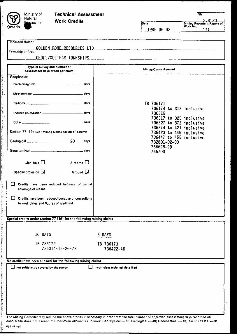
Technical Assessment Work Credits Date
1585 06 03
File
2.Ri?nMining Recorder's Report of Work No.
1?7
Recorded Holder
GOLDEN POND RESOURCES l TDTownship or Area
i /mi TH&M
Type of survey and number of Assessment days credit per claim
Geophysical
Flertrnmagnntir
Mflgnntnmpter
Rudinmetrir
Induced pnlari;ation
Other
Section 77 (19) See "Mining Cleimi Assessed'
Renlngiral 20
finnr.hRmiral
days
days
days
days
days
' column
dayt
days
Man days C3 Airborne D
Special provision Q Ground Cj3
O Credits have been reduced becausecoverage of claims.
Q Credits have been reduced because ofto work dates and figures of applicant.
of partial
corrections
Mining Claims Assessed
TD "1 O C1 7 1ID 7 OD 1/1
736174 to 313TOCO1 C7 00 JlD
736317 to 325736327 to 372736374 to 421736423 to 445736447 to 455732801-02-03766698-99766700
Inclusive
inclusiveinclusiveinclusiveinclusiveinclusive
Special credit! under section 77 (16) for the following mining claims
10 DAYS
TB 736172736314-16-26-73
5 DAYS
TB 736173 736422-46
No credits have been allowed for the following mining claims
LJ not sufficiently covered by the survey LJ Insufficient technical data filed
The Mining Recorder may reduce the above credits if necessary in order that the total number of approved assessment days recorded on each claim does not exceed the maximum allowed as follows: Geophysical — 80; Geological — 40; Geochemical — 40; Section 77 (19)—60:028 (83f6t
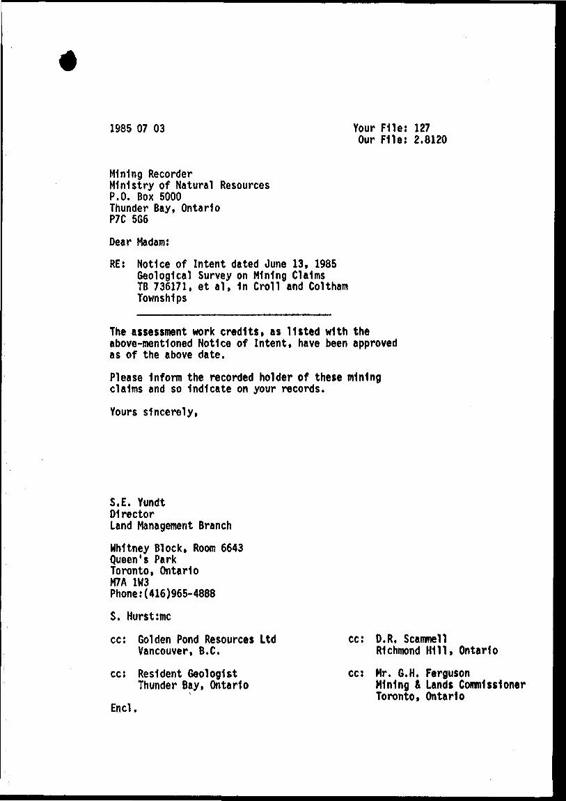
1985 07 03 Your File: 127 Our File: 2.8120
Mining RecorderMinistry of Natural ResourcesP.O. Box 5000Thunder Bay, OntarioP7C 5G6
Dear Madam:
RE: Notice of Intent dated June 13, 1985 Geological Survey on Mining Claims TB 736171, et al, 1n Croll and Coltham Townships
The assessment work credits, as listed with the above-mentioned Notice of Intent, have been approved as of the above date.
Please Inform the recorded holder of these mining claims and so Indicate on your records.
Yours sincerely,
S.E. YundtDirectorLand Management Branch
Whitney Block, Room 6643 Queen's Park Toronto, Ontario M7A 1M3 Phone:(416)965-4888
S. Hurst:mc
cc: Golden Pond Resources Ltd Vancouver, B.C.
cc: Resident Geologist Thunder Bay, Ontario
Encl.
cc: D.R, ScammellRichmond Hill, Ontario
co Mr. G.H. FergusonMining fi Lands Commissioner Toronto, Ontario
Ministry of Natural
f P-sourcesf; Ontario, \ J
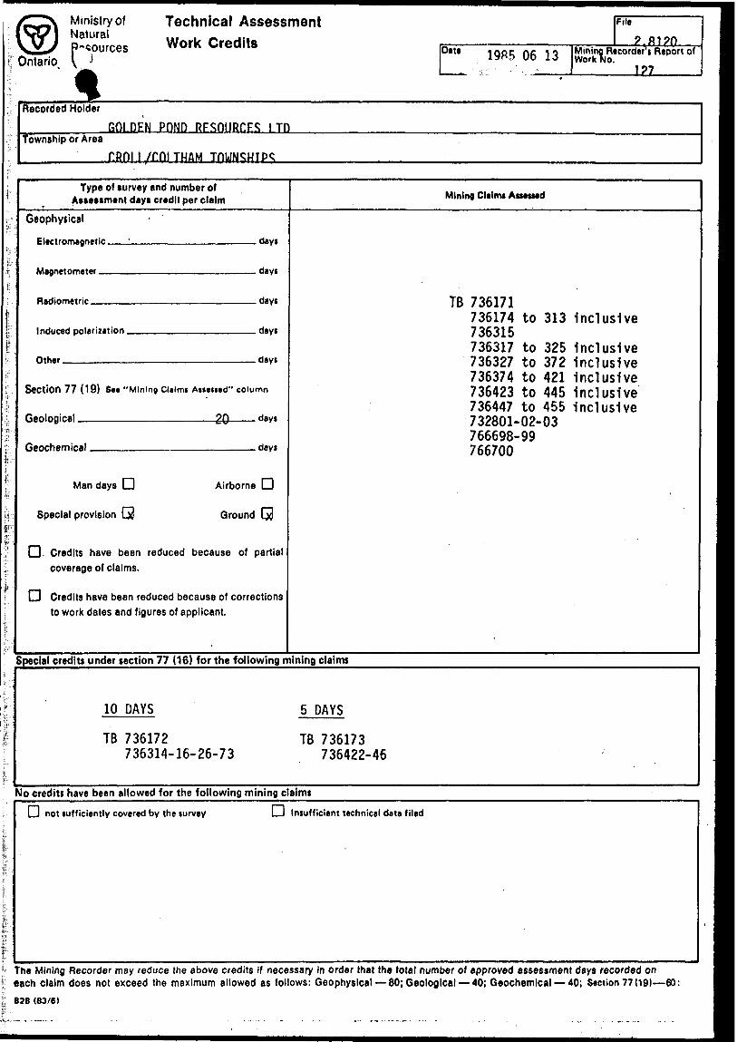
Technical Assessment Work Credits
D8W 1 985 06 13
File
? fti?nMining Recorder's Report of Work No.
1?7
Recorded Holder
Township or AreaGOLDEN POND RESOURCES lin
i /rni TH&M
i"
fi
f"
T:
fF
f'
:"
j
'f
Fi;l
a-'
F
E
,.
Is
i-
Type of survey and number of Assessment dayt credit per claim
Geophysical
Electromagnetic '
M tomntor
Inrluf-art polarization
nth.r
Section 77 (19) Se* "Mining Clalmt Aliened'
ftpnlnniral 9Q
fipnrhpmif*Al
days
dayi
dayt
days
days
' column
dayt
dayt
Man days CD Airborne CD
Special provision Q Ground Cxl
Q. Credits have been reduced becausecoverage of claims.
Q Credits have been reduced because ofto work dates and figures of applicant.
of partial
corrections
Mining Claims Assessed
TB 736171736174 to 313736315736317 to 325736327 to 372736374 to 421736423 to 445736447 to 455732801-02-03766698-99766700
inclusive
InclusiveinclusiveInclusiveinclusiveinclusive
Special credits under section 77 ( 16) for the following mining claims
10 DAYS
TB 736172736314-16-26-73
.5 DAYS
TB 736173 736422-46
No credits have been allowed for the following mining claims
LJ not sufficiently covered by the survey O Insufficient technical data filed
The Mining Recorder may reduce the above credits if necessary in order that the total number of approved assessment days recorded on each claim does not exceed the maximum allowed as follows: Geophysical — 80; Geological — 40; Geochemical — 40; Section 77 (19)—60:828 (83/6)
llano
Ministry ofNaturalResources
1985 06 13 Your File: 127Our File: 2.8120
Mining RecorderMinistry of Natural ResourcesP.O. Box 5000Thunder Bay, OntarioP7C 5G6
Dear Madam:
Enclosed are two copies of a Notice of Intent with statements listing a reduced rate of assessment work credits to be allowed for a technical survey. Please forward one copy to the recorded holder of the claims and retain the other. In approximately fifteen days from the above date, a final letter of approval of these credits will be sent to you. On receipt of the approval letter, you ma,y then change the work entries on the claim record sheets.For further information, if required, pi eas.e contact Mr. R.J. Pichette at 416/965-4888.
sincerely,
i.E. YXmdt lirex
Land Management Branch
Whitney Block, Room 6643 Queen's Park Toronto, Ontario M7A 1W3
-S. Hurst:mc
Ends.
cc: Golden Pond Resources LtdSuite 1520609 Granville StreetBox 10352Vancouver, B.C.V7Y 1G5
cc: D.R. Scammell298 Ruggles AvenueRichmond Hill, OntarioL4C 1Z1
cc: Mr. G.H. FergusonMining a Lands Commissioner Toronto, Ontario
845
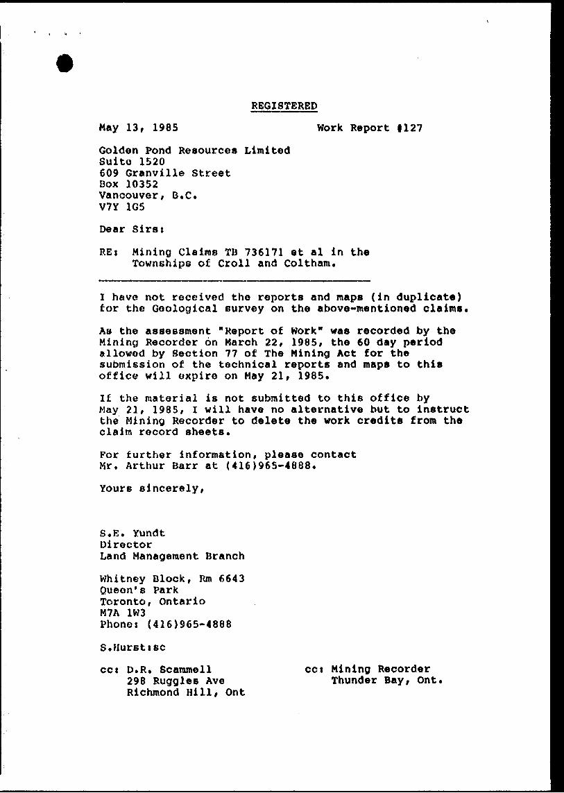
REGISTERED
May 13, 1985 Work Report 1127
Golden Pond Resources LimitedSuite 1520609 Granville StreetBox 10352Vancouver, B.C*V7Y 1G5
Dear Sirs:
RE i Mining Claims TD 736171 et al in the Townships of Croll and Coltham.
I have not received the reports and maps (in duplicate) for the Geological survey on the above-mentioned claims*
AB the assessment "Report of Work" was recorded by the Mining Recorder on March 22, 1985, the 60 day period allowed by Section 77 of The Mining Act for the submission of the technical reports and maps to this office will expire on May 21, 1985.
If the material is not submitted to this office by May 21, 1985, I will have no alternative but to instruct the Mining Recorder to delete the work credits from the claim record sheets.
For further information, please contact Mr. Arthur Barr at (416)965-4688.
Yours sincerely,
S.E. YundtDirectorLand Management Branch
Whitney Block, Rm 6643 Queen's Park Toronto, Ontario M7A 1W3 Phones (416)965-4888
S.Hursttsc
cct D.R. Scammell 298 Ruggles Ave Richmond Hill, Ont
cct Mining Recorder Thunder Bay, Ont*
Ministry ofNaturalResources
Ontario
Notice of Intent
for Technical Reports
1985 06 13 2.8120/127
An examination of your survey report indicates that the requirements of The Ontario Mining Act have not been fully met to warrant maximum assessment work credits. This notice is merely a warning that you will not be allowed the number of assessment work days credits that you expected and also that in approximately 15 days from the above date, the mining recorder will be authorized to change the entries on his record sheets to agree with the enclosed statement. Please note that until such time as the recorder actually changes the entry on the record sheet, the status of the claim remains unchanged.
If you are of the opinion that these change's by the mining recorder will jeopardize your claims, you may during the next fifteen days apply to the Mining and Lands Commissioner for an extension of time. Abstracts should be sent with your application.
If the reduced rate of credits does not jeopardize the status of the claims then you need not seek relief from the Mining and Lands Commissioner and this Notice of Intent may be disregarded.
If your survey was submitted and assessed under the "Special Provision-Performance and Coverage" method and you are of the opinion that a re-appraisal under the "Man-days" method would result in the approval of a greater number of days credit per claim, you may, within the said fifteen day period, submit assessment work breakdowns listing the employees names, addresses and the dates and hours they worked. The new work breakdowns should be submitted direct to the Land Management Branch, Toronto. The report will be re-assessed and a new statement of credits based on actual days worked will be issued.
646 I82/&)
MmiSlryol
Natural , Resources
Ontario i
Report of Work {Geophysical. Geological, Geochemical a nd E xpenditures)
736-17Mining Act
Instructions: -
Noir -
Plr.isf UP' O' prmi.11 mimln 1 ' o' minifip f Unrris l r^vcr sr l I'nfiTtJi iit.it*1 on this io'm, fllt,(th a O'^v ^'W- ci *'(I'K call u lair M , n i h "t *f)'' n i;l!luiCi" srctit,)n fn.^v Ix 1 entert in ttip "Expcnci. Days C' " column Do nol yif shaded arras below
Type o' Su'veyUI
___ _ _GeologicalClaim Hofder(i)"
Golden Pond Resources Ltd.
J l ownihip o r Area V/^ - *i*4 ' *
jCroll/Colthaml ^ ^ ^ ^ ^,,
Prospector's Licence No.
T 1655Addreti
Survey Company
...JMet.allge.sellschaft Canada .Ltd,,
.
Date of Survey (from A to)
O-
Total Miles of line Cut
198.5(319.4 kmt)Name and Address of Author (of Geo Technical report)
D. R. Scammell, 298 Ruggles Ave., Richmond Hill, Ont. L4C 1Z1Credits Requested per Each Claim in Columns at rightSpecial Provisions
For first survey:
Enter 40 dayt. (This includes line cutting)
For each additional survey: using the same grid:
Enter 20 days (for each)
Man Days
Complete reverse side and enter total(s) here
Mining Claims Traversed (List in numerical sequence)Geophysical
- Electromagnetic
- Magnetometer
- Radiometric
- Other
Geological
Geochemical
Geophysical
- Electromagnetic
- Magnetometer
- Radiornetric
—- Othe
Geological
r r Mther,, V*- t'"
Geochemica
Airborne Credits
Note: Special provisionscredits do not apply to Airborne Surveys.
r'-' ' AW l-*' 1'-'''Electromagnetic
Magnetometer
Radiometric
Expenditures (excludes power stripping)Type of Work Performed
Performed on Claim(s)
Calculation of Expenditure Days Credits
Total Expenditures
S -h 151-11,1.-,. i.nm
Total Days Credits
=
in columns ai right
Date Record cd Holder or Agent (Signature)
Certification Verifying Report of Workl hereby certify that l have a personal end intimate knowledge of the (acts set forth in the Report of Work annexed hereto, having performed the work or witnessed same during and/or after its completion and the annexed repon is true.
Name and Postal Address of Person CeMityinfl
— .-P.*.—R.-'-. .^cajiynelJL. j-...29.8—Rug.gle.s-Ave..- Richmond Hill, Ont. LAC 1 Z1
Date Certified Certified by (Signature)
136? (81/9)
Mining Claim Prefix Number
TB736
T ..- VX
Days Prefix Number Days Prefix Number DaysTB736
•2TT
ti TB736
ZTT
Mining Claim Prefix Number Days
TB736
ttST
(to
Pre fix Number Days Prefix Number Days
TB 736 -34-t- 4f) TB 736 *3TT
-34-4-
t ,
Mining Claim
TB 736
42:
Prefix Number Days TB 736
732 .801-
766
766 JLOO
G-3
OT
OA
KE
ST
WP
SLO
NG
LA
CA
LF
RE
DL
AK
E
736335/
736
349
l 7
36
36
6
736
377
7362
51
73
62
70
7362
81
736
296
7593
11
736397 [
73
64
12
736427
——
-——
—l—
——
L——
—l
j l
J_
\
l__l_
__l
__
_
736
348
73
6 36
7 |7
36
376
736252
7
36
ZG
9 l 7
36 2
82
7
36
29
7
73
6 3
12 l
736V
396
| 73
6 4
13
7364261736444
VI_
___U
——
a
-ra
l
TR
l_____ '_
__
__
__
_._
__
__
__
__
__
__
__
.__
__
__
__
__
__
_J_
__
__
__
L_
__
__
_-l—
——
__
_f-
——
——
—L
.TB
TT
B T6
T
TB
TB
IT
B
TB
TB
ITB
. j&
J i
73
6224
l 73
6239
1 7
3625
31 7
36
26
8
736283
73
6 2
96
l 7
3B
3 1
3JJ7
36 3
95 l
73
6 4
14
l 73
6 4
25 |
73
6 4
45
736
-315
(1-7
36 3
37
&H
.——
——
——
——
——
——
——
—y^/
jg
(736
187
736)9
8 |7
362"ll
J 7
36
22
5
73
62
38
|736 2
54 j
73
6 2
67
| 73
6 28
4 |
736
295
l 736
314
736394
736
l T
D
\T
0
.-m
^
~R
B^^
|TB
l™
94^7
31 3
15^7
36 3
93
736
73
6 1
86
736
199
736
210
73
62
26
l
73
62
37
736255
73
62
66
7
36
28
5
-^—
4-—
—K-
----J
——
4-—
—V
'^.^^
03 S
7
36
185
l 7
36
20
0
736209
73
6 2
27
17
36
23
6 1
736
256736 2
65 736296736 2
9317363891736 3
92p36*l7
;736)4
22
736
45
3
736
340
17
36 3
44
173
6 37
1 73
6 37
2X
l
__
—-f
- '—
——
l——
—
64
|73
6
28
7I7
36
29
2L
73
6 3
8817
3639
1 7
36
41
8i
f i
L
X
__
_ _
__
__
___J^
^^
.™
—-i
___
- .
fri
]TB
~tr
?X
IT
B
Hfi
ffri
TTB
"iI
.-
,-—
p - —
l
A \
P l
73
62
9
17
36
23
4
1736
2581
,736
263
73
6 28
8 73
6 29
1 7
36
387
'. 73
639O
J73
6 41
9 I7
3642
OC
RO
LL
TW
PC
OLT
HA
M
T W
P'b
m C
736 1
82
736203
736206
r 7
36
Z30
t
736233
736
204
[736
J205
t7
3623
2| 7
36 2
9O 7
36
38
6 73
6 28
i i
. i
i
736
181
73
62
31
73
6 25
9 736260 7
36
261
73
62
62
17
6
69
86
99
GO
LDEN
PO
ND
/MC
L JO
INT
VEN
TUR
EC
roll/
Colth
am
Tow
nshi
ps,
Thun
der
Bay
Min
ing
Div
isio
n,
Ger
aldt
on,
NT
S 4
2/E
10
CL
AIM
S
MA
P
2.8
128
CR
OLL
200
TR
AN
SL
Al
LE
GE
ND
PL
EIS
TO
CE
NE
Till
UN
CO
NF
OR
MIT
Y
PR
EC
AM
BR
IAN
MID
DLE
8
LA
TE
P
RE
CA
MB
RIA
N
MA
FIC
IN
TR
US
IVE
R
OC
KS
6 D
iab
as
e6a
P
orph
yriti
c di
abas
e
EA
RL
Y
PR
EC
AM
BR
IAN
(A
RC
HE
AN
)
FE
LS
IC
TO
IN
TE
RM
ED
IAT
E
INT
RU
SIV
E
RO
CK
S
5
Un
sub
div
ide
d5a
M
ass
ive
5b
Fo
lia
ted
5c
Gra
nite
5d
Dio
rite
, Q
ua
rlz
dio
rite
, G
ran
od
iori
te
MA
FIC
T
O
UL
TR
AM
AF
IC
INT
RU
SIV
E
RO
CK
S
4
Un
sub
div
ided
4a
Ga
bb
ro,
Ho
rnb
len
de
ga
bb
ro
ME
TA
SE
D1M
EN
TS
3 U
nsub
divi
ded
3a
Co
ng
lom
era
te
3b
San
dsto
ne,
Are
nit
e,
Ark
os
e,
Wac
ke ,
Qu
art
zit
e
3c
Sil
tsto
ne
3d
Arg
illite
, P
hylli
te,
Mud
ston
e,
Sha
le
3e
Gra
phite
3f
Iron
form
atio
n
FE
LS
IC
TO
INT
ER
ME
DIA
TE
M
ET
AV
OL
CA
NIC
S
2 U
nsu
bd
ivid
ed
2a
Rh
yolit
e (m
as
siv
e,
foli
ate
d,
sh
ea
red
)
2b
R
hyo
lite
po
rph
yry
, Q
ua
rtz
- fe
ldsp
ar
po
rph
yry
2c
Dac
ite,
Rhy
odac
ite2d
L
apill
i-tu
lf,.
C
rysta
l!-t
uff,
Lapilli-t
uff
2e
Ser
icite
sc
hist
MA
FIC
T
O
INT
ER
ME
DIA
TE
M
ET
AV
OLC
AN
ICS
l U
nsu
bdiv
ided
la
Basa
lt to
andesi
te :
mass
ive,
folia
ted
Ib
Ba
salt
to
an
de
site
; sc
his
tose
, sh
eare
d
le
Bas
alt
to
ande
site
- pi
llow
edId
B
asal
t to
an
desi
te:
porp
hyrit
ic!e
B
asal
t to
an
desi
te;
amyg
dalo
id,
vesi
cula
rIf
C
hlo
rite
sc
his
t
lg
Tu
ff
Ih
Vol
cani
c br
ecci
a (a
gglo
mer
ate,
la
pill
i-tu
ff,
tuff -
brec
cia)
•c? Q x
Geo
logi
cal
cont
act
Out
crop
Ou
tcro
p ^
4 s
q. m
)
Are
a
of
ou
tcro
p
Sch
isto
sity
(ve
rtic
al)
Sch
isto
sity
(di
p de
term
ined
) S
chis
tosi
ty
(dip
no
t de
term
ined
)
Cle
avag
e (v
ert
ical)
Cle
avag
e (d
ip
dete
rmin
ed)
Cle
avag
e (d
ip
not
dete
rmin
ed)
Join
t (v
ert
ica
l)Jo
int
(dip
d
ete
rmin
ed
)
Join
t (d
ip
not
dete
rmin
ed)
Cla
im
po
st
(loc
ated
)
Cla
im
po
st
(no
t lo
ca
ted
)
Stre
am
(dire
ctio
n of
flo
w i
ndic
ated
)S
tream
(inte
rmitt
ent)
Sw
amp
Bea
ver
dam
Tre
nch
Fault,
she
ar
ser
serici
tized
pot
pota
ssic
al
tera
tion
carb
carb
on
ati
zed
chl
chlo
riliz
ed
sil
silic
ifie
dep
id
epid
ote
tour
tour
mal
ine
qtz
q
uart
z
q.v.
quar
tz
vein
mag
m
agne
tite
cpy
ch
alc
op
yri
te
py
py
rite
po
pyrr
ho
tite
sph
spha
lerit
em
o m
oly
bd
en
ite
hem
he
mat
itepb
le
adAu
go
ld
cgf
coar
se
grai
ned
flow
amph
am
phib
olite
xen
xe
no
lith
SC
AL
E:C
OO
OM
ET
RE
S
O 5
0
100
3OO
5OO
META
LLGE
SELL
SCHA
FT
CANA
DA
LIMITE
DG
OLD
EN
PO
ND
/MC
L JO
INT
VE
NTU
RE
Cro
ll T
owns
hip,
Th
unde
r B
ay
Min
ing
Div
isio
n,
Ont
ario
N.T
.S.
42
E X
10
Wo
rk
byD
ate.
Dra
wn
byD
PS
Dat
e:J
an
1
98
5
' 500O
Dra
win
g
No
shee
t l
of
6
750
V
/"28
0
736195 lo
(cg
f)
LE
GE
ND
PLE
IST
OC
EN
E
Till
UN
CO
NF
OR
MIT
Y
PR
EC
AM
BR
IAN
MID
DL
E
8
LA
TE
P
RE
CA
MB
RIA
N
MA
FIC
IN
TR
US
IVE
R
OC
KS
6
Dia
base
Ga
Por
phyr
itic
diab
ase
EA
RL
Y
PR
EC
AM
BR
IAN
(A
RC
HE
AN
)
FE
LS
IC
TO
IN
TE
RM
ED
IAT
E
INT
RU
SIV
E
RO
CK
S
5 U
nsu
bd
ivid
ed
5a
Mas
sive
5b
Fo
liate
d5c
G
ran
ite5d
D
iorite
, Q
ua
rtz
dio
rite
, G
ran
od
iori
te
MA
FIC
T
O
UL
TR
AM
AF
IC
INT
RU
SIV
E
RO
CK
S
4 U
nsu
bd
ivid
ed4a
Ga
bb
ro,
Ho
rnb
len
de
gab
bro
ME
TA
SE
DIM
EN
TS
3 U
nsub
divi
ded
3a
Con
glom
erat
e3b
S
ands
tone
, A
renite
, A
rkos
e, W
acke
, Q
uart
zite
3c
Silt
ston
e3d
A
rgill
ite
, P
hylli
te,
Mud
ston
e,
Sha
le
3e
Gra
phite
3f
Iron
fo
rma
tion
FE
LS
IC
TO
INT
ER
ME
DIA
TE
M
ET
AV
OL
CA
NIC
S
2 U
nsub
divi
ded
2a
Rh
yo
lite
(m
assiv
e,
foliate
d,
sh
ea
red
)
2b
Rh
yolit
e p
orp
hyr
y,
Qu
artz
- f
eld
spar
p
orp
hyr
y
2c
Dacit
e,
Rh
yo
dacit
e
2d
L
ap
illi-t
uff
, C
rysta
ll-t
uff,
Lap
illi-t
uff
2e
Se
ric
ite
s
ch
ist
MA
FIC
T
O
INT
ER
ME
DIA
TE
M
ET
AV
OLC
AN
ICS
l U
nsu
bd
ivid
ed
la
Bas
alt
to
ande
site
- m
assi
ve,
folia
ted
Ib
Ba
salt
to
an
desit
e--
sc
his
tos
e,
she
ared
le
Bas
alt
to
ande
site
; pi
llow
edId
B
asalt
to
an
desit
e:
po
rph
yri
tic
le
Basalt
to
a
nd
es
ite
: am
yg
dalo
id,
ve
sic
ula
r
If
Ch
lorite
schis
t
lg
Tu
ff
Ih
Vo
lcan
ic
bre
cc
ia (
ag
glo
me
rate
, la
pilli-
tuff
, tu
ff-
bre
ccia
)
Q
Geo
logi
cal
cont
act
Out
crop
Out
crop
^4
sq.
m)
Are
a of
ou
tcro
p
Sch
isto
sity
(ve
rtic
al)
Sch
isto
sity
(di
p de
term
ined
)S
chis
tosi
ty
(dip
no
t de
term
ined
)
Cle
avag
e (v
ert
ical)
Cle
av
ag
e
(dip
de
term
ine
d)
Cle
av
ag
e
(dip
no
t d
eter
min
ed)
Join
t (v
ert
ica
l)
Join
t (d
ip
de
term
ine
d)
Jo
int
(dip
n
ot
dete
rmin
ed
)
Cla
im
post
(lo
cate
d)
Cla
im
post
(no
t lo
cate
d)
Str
ea
m
(dir
ec
tio
n
of
flow
in
dic
ate
d)
Stre
am
(inte
rmitt
ent)
Sw
amp
Bea
ver
dam
Tre
nch
Fau
lt, s
hear
ser
se
ric
itiz
ed
po
t p
ota
ssic
alt
era
tio
n
carb
c
arb
on
ati
zed
chl
ch
lori
tize
d
sil
silic
ifie
dep
id
epid
ote
tou
r to
urm
alin
e
qtz
q
uart
z
q.v.
q
ua
rtz
ve
in
mag
m
agne
tite
cpy
chal
copy
rite
py
py
rite
po
pyr
rho
tite
sph
sph
ale
rite
mo
mol
ybde
nite
hem
h
em
ati
te
pb
lead
Au
g
old
cgf
coar
se
grai
ned
flow
amph
am
phib
olit
exe
n xe
nolit
h
SC
ALE
: 5O
OO
ME
T R
ES
O
50
1O
O3
00
5OO
META
LLGE
SELL
SCHA
FT
CANA
DA
LIMITE
DG
OLD
EN
PO
ND
/MC
L
JOIN
T V
EN
TU
RE
Cro
ll To
wns
hip,
Th
unde
r B
ay
Min
ing
Div
isio
n,
Ont
ario
NT
S. 4
2 E
f 1O
GEO
LOG
YW
ork
byD
ate
Dra
wn
by
DR
SD
ate;
Jan.
19
85
Sca
'e
1 5
0O
O
shee
t 2
of
6
42
E1
0N
Ea
e5
1
2.8
12
0
CR
OL
L21
0
42E
ieN
E(W
51
2.8
12
* C
RO
LL
LE
GE
ND
PLE
IST
OC
EN
E
Till
UN
CO
NF
OR
MIT
Y
PR
EC
AM
BR
IAN
MID
DLE
a
LA
TE
P
RE
CA
MB
RIA
N
MA
FIC
IN
TR
US
IVE
R
OC
KS
6 D
iaba
se6a
P
orph
yriti
c di
abas
e
EA
RLY
P
RE
CA
MB
RIA
N
(AR
CH
EA
N)
FE
LS
IC
TO
INT
ER
ME
DIA
TE
IN
TR
US
IVE
R
OC
KS
5 U
nsu
bd
ivid
ed
5a
Mas
sive
5b
Fo
liate
d5c
G
ranite
5d
D
iorite
j Q
ua
rtz
dio
rite
, G
ranodio
rite
MA
FIC
T
O
UL
TR
AM
AF
IC
INT
RU
SIV
E
RO
CK
S
4 U
nsub
divi
ded
4a
Gab
bro,
Hor
nble
nde
gabb
ro
ME
TA
SE
DIM
EN
TS
3 U
nsub
divi
ded
3a
Con
glom
erat
e3b
S
andst
one,
Are
nite
, A
rkose
, W
acke
, Q
uart
zite
3c
Silt
stone
3d
Arg
illite
, P
hylli
te,
Mud
ston
e,
Sha
le
3e
Gra
phite
3f
Iron
form
atio
n
FE
LS
IC
TO
INT
ER
ME
DIA
TE
M
ET
AV
OLC
AN
ICS
2 U
nsub
divi
ded
2a
Rhy
olite
(m
assi
ve,
folia
ted,
sh
eare
d)2b
R
hyo
lite
porp
hyr
y,
Quart
z -
feld
spar
porp
hyr
y
2c
Daci
te,
Rh
yod
aci
te
2d
La
pill
i-tu
ff,
Cry
sta
ll-t
uff.
Lapilli-t
uff
2e
Ser
icite
sc
hist
MA
FIC
T
O
INT
ER
ME
DIA
TE
M
ET
AV
OLC
AN
ICS
l U
nsub
divi
ded
la
Bas
alt
to
ande
site
- m
assi
ve,
folia
ted
Ib
Bas
alt
to
ande
site
-- s
chis
tose
, sh
eare
dle
B
asal
t to
an
desi
te;
pillo
wed
Id
Bas
alt
to
ande
site
; po
rphy
ritic
le
Bas
alt
to
ande
site
- am
ygda
loid
, ve
sicu
lar
If
Ch
lorite
sc
his
t
lg
Tu
ff
Ir
Vol
cani
c br
ecci
a (a
gglo
mer
ate,
la
pill
i-tu
ff,
tuff
- br
ecci
a)
a x
Geo
logi
cal
cont
act
Out
crop
Outc
rop ^4
sq.
m)
Are
a
of
outc
rop
Sch
isto
sity
(ve
rtic
al)
Sch
isto
sity
(di
p de
term
ined
) S
chis
tosi
ty (
dip
not
dete
rmin
ed)
Cle
avag
e (v
ertic
al)
Cle
ava
ge
(dip
d
ete
rmin
ed
)
Cle
avag
e (d
ip
not
dete
rmin
ed)
Join
t (v
ert
ica
l)Join
t (d
ip
dete
rmin
ed)
Join
t (d
ip
not
dete
rmin
ed)
Cla
im
post
(lo
cate
d)
Cla
im
post
(no
t lo
cate
d)
Stre
am (
dire
ctio
n of
flo
w i
ndic
ated
)St
ream
(in
term
itten
t)S
wam
pB
eave
r d
am
Tren
chF
au
lt,
she
ar
ser
se
ricitiz
ed
pot
pota
ssic
al
tera
tion
carb
ca
rbo
na
tized
chl
chlo
ritiz
edsi
l si
licifi
ed
epid
ep
idot
eto
ur
tour
mal
ine
qtz
q
ua
rtz
q.v-
q
ua
rtz
vein
mag
m
agne
tite
cpy
chal
copy
rite
p y
pyrite
po
pyrr
ho
tite
sph
sph
ale
rite
mo
mo
lybd
en
ite
hem
he
mat
itepb
le
ad
Au
gold
cgf
coar
se
grai
ned
flow
amph
am
phib
olite
xen
xenolit
h
SC
AL
E:
SO
OO
ME
TR
ES
O 5O
10
03O
O5
00
META
LLGE
SELL
SCHA
FT
CANA
DA
LIMITE
DG
OLD
EN
P
ON
D/M
CL
JOIN
T
VE
NT
UR
EC
roll
Tow
nshi
p,
Thun
der
Bay
M
inin
g D
ivis
ion,
O
ntar
io
——
N.T
.S.
42
E f
10
GEO
LOG
YW
ork
byD
ate:
Dra
wn
by-
OPS
Da
te;
Jan
1
98
5
Sca
le' 5
00
0D
raw
ing
No-
shee
t 3
of
6T
RA
NU
-AR
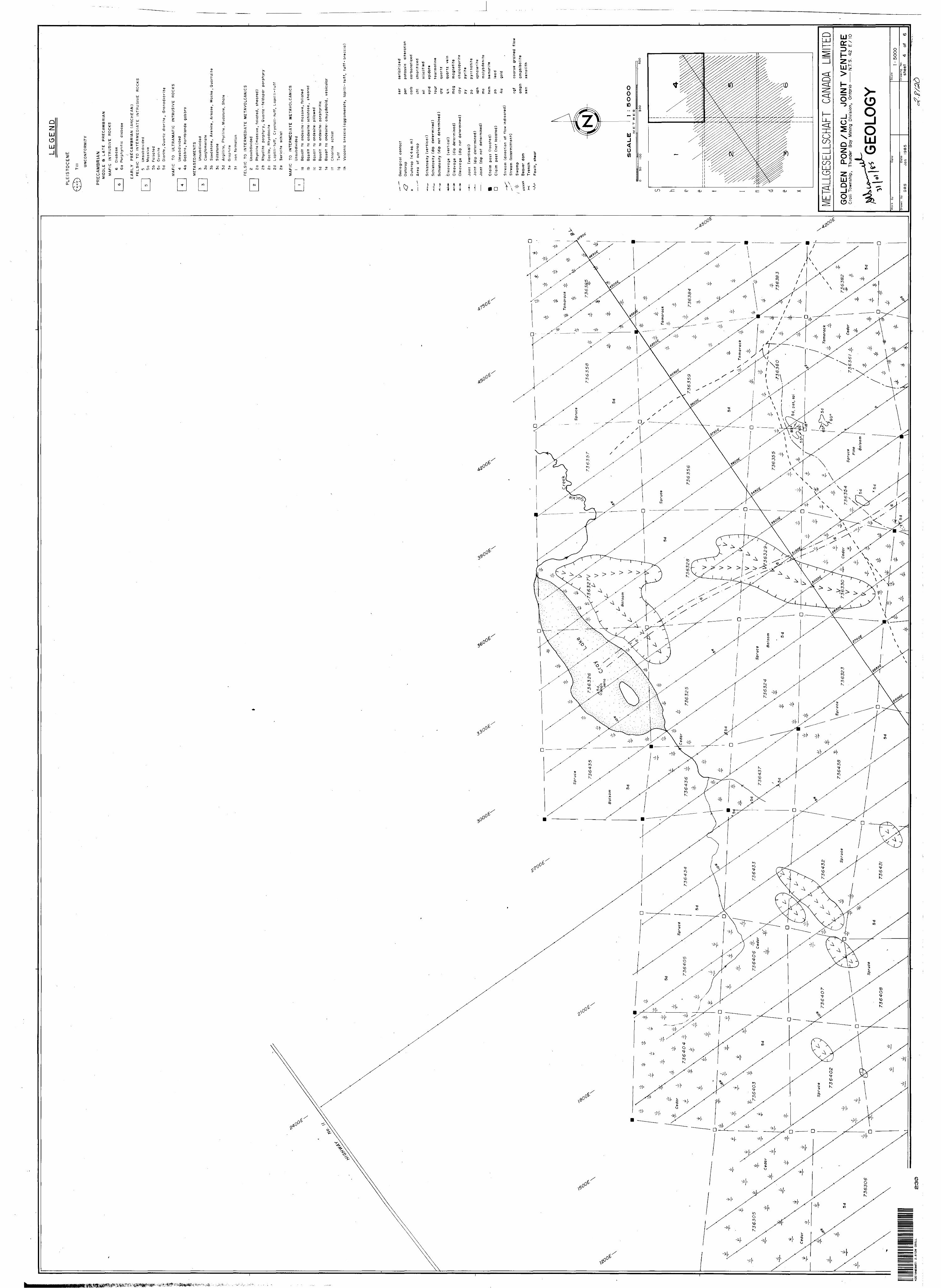
LE
GE
ND
PLE
IST
OC
EN
E
Till
UN
CO
NF
OR
MIT
Y
PR
EC
AM
BR
IAN
MID
DLE
S
LA
TE
P
RE
CA
MB
RIA
N
MA
FIC
IN
TR
US
IVE
R
OC
KS
6 D
iab
as
e
6a
Porp
hyritic
dia
base
EA
RL
Y
PR
EC
AM
BR
IAN
(A
RC
HE
AN
)
FE
LS
IC
TO
IN
TE
RM
ED
IAT
E
INT
RU
SIV
E
RO
CK
S
5 U
nsu
bd
ivid
ed
5a
Mas
sive
5b
Fol
iate
d5c
G
ran
ite5d
D
iorite
, Q
ua
rtz
dio
rite
, G
ran
od
iori
te
MA
FIC
T
O
UL
TR
AM
AF
IC
INT
RU
SIV
E
RO
CK
S
4
Un
sub
div
ided
4a
G
ab
bro
, H
orn
ble
nd
e g
abb
ro
ME
TA
SE
DIM
EN
TS
3 U
nsub
divi
ded
3a
Co
ng
lom
era
te
3b
S
an
dsto
ne,
Are
nit
e,
Ark
os
e,
Wa
ck
e ,
Qu
art
zit
e
3c
Sil
tsto
ne
3d
Arg
illite
, P
hyl
lite,
Mud
ston
e, S
hale
3e
Gra
ph
ite
3f
Iron
fo
rmatio
n
FE
LS
IC
TO
IN
TE
RM
ED
IAT
E
ME
TA
VO
LC
AN
IC S
2 U
nsu
bd
ivid
ed
2a
Rh
yo
lite
(m
assiv
e,
foli
ate
d,
sh
ea
red
)
2b
R
hyo
lite
porp
hy
ry,
Qu
art
z -
feld
sp
ar
po
rph
yry
2c
Dacit
e,
Rhyo
daci
te
2d
La
pill
i-tu
ff,
Cry
sta
l!-t
uff
, L
apilli-t
uff
2e
Ser
icit
e sc
his
t
MA
FIC
T
O
INT
ER
ME
DIA
TE
M
ET
AV
OL
CA
NIC
S
l U
nsu
bd
ivid
ed
la
Bas
alt
to
and
esit
e - m
assi
ve,
folia
ted
Ib
Bas
alt
to
and
esit
e ; s
chis
tose
, sh
eare
d
le
Basa
lt to
a
nd
esit
e ;
pillo
wed
Id
Ba
sa
lt
to
an
desit
e:
po
rph
yri
tic
le
Bas
alt
to
ande
site
? am
ygd
alo
id,
vesi
cula
r
If
Chlo
rite
sc
his
t
lg
Tu
ff
Ih
Vo
lca
nic
b
reccia
(a
gg
lom
era
te,
lapill
i- t
uff
, tu
ff-
bre
ccia
)
D
Geo
log
ical
co
nta
ct
Ou
tcro
p
Out
crop
^4
sq.
m)
Are
a of
ou
tcro
p
Sch
isto
sity
(ve
rtic
al)
Sch
isto
sity
(di
p de
term
ined
)
Sch
isto
sity
(d
ip
not
dete
rmin
ed)
Cle
avag
e
(vert
ical)
Cle
avag
e (d
ip
det
erm
ined
)
Cle
avag
e
(dip
n
ot
de
term
ine
d)
Join
t (v
ert
ica
l)Jo
int
(dip
de
term
ined
)Jo
int
(dip
n
ot
de
term
ined
)
Cla
im
post
(lo
cate
d)
Cla
im
post
(n
ot
loca
ted)
Str
eam
(d
ire
ctio
n
of
flo
w
ind
ica
ted
)
Stre
am
(inte
rmitt
ent)
Sw
amp
Beav
er d
amT
renc
hF
au
lt,
sh
ea
r
ser
serici
tized
pot
pota
ssic
al
tera
tion
carb
c
arb
on
ati
zed
chl
chlo
ritiz
ed
sil
silic
ified
epid
e
pid
ote
tou
r to
urm
alin
e
qtz
q
uart
z
q.v.
q
uart
z
vein
mag
m
agne
tite
cp
y
ch
alc
op
yri
te
py
py
rite
po
p
yrr
ho
tite
sph
spha
lerit
em
o
mo
lyb
de
nit
e
hem
h
em
ati
te
pb
lead
Au
gold
cgf
coar
se
grai
ned
flow
amph
am
phib
olite
xen
xe
no
lith
SC
AL
E:
SO
OO
ME
T R
ES
O 50
100
3OO
50
O
META
LLGE
SELL
SCHA
FT
CANA
DA
LIMITE
DG
OLD
EN
PO
ND
/MC
L
JOIN
T V
EN
TU
RE
Cro
ll-T
owns
hip,
Th
unde
r B
ay
Min
ing
Div
isio
n,
Ont
ario
——
—N
.T.S
. 42
E X
10
GEO
LOG
YW
ork
by
Dat
e-
Dra
wn
byD
RS
Dat
e,
Jan
1985
Sca
le'5
00
0
Dra
win
g
No.
shee
t 4
of
6
42
E1
0N
Ee
e5
1
2.8
12
0
CR
OL
L2
30
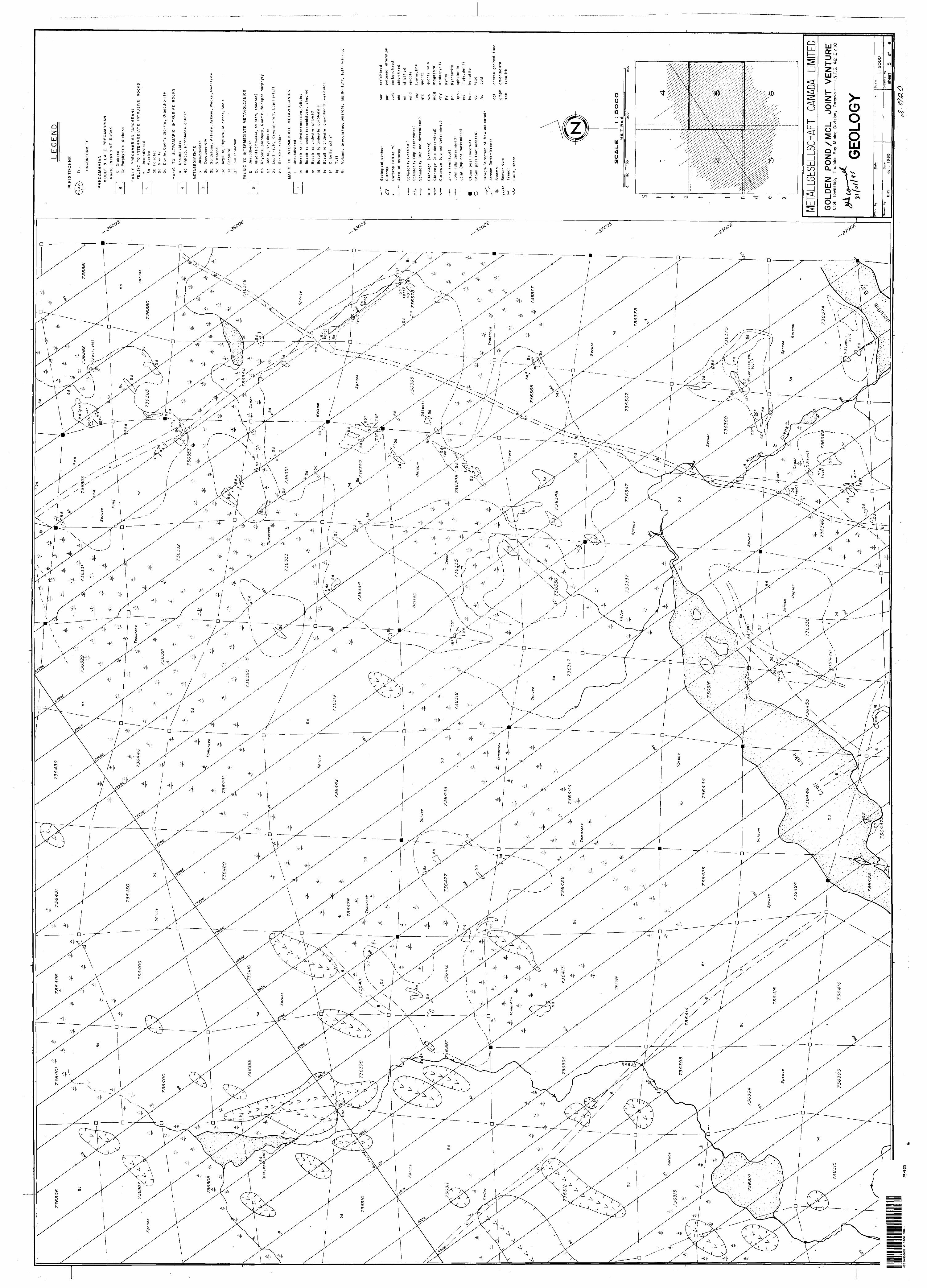
5 d sh
, qv
, ca
rb,
chl,
tour.
)
LE
GE
ND
PLE
IST
OC
EN
E
Till
UN
CO
NF
OR
MIT
Y
PR
EC
AM
BR
IAN
MID
DLE
8
LA
TE
P
RE
CA
MB
RIA
N
MA
FIC
IN
TR
US
IVE
R
OC
KS
6 D
iaba
se6a
P
orph
yriti
c di
abas
e
EA
RL
Y
PR
EC
AM
BR
IAN
(A
RC
HE
AN
)
FE
LSfC
T
O
INT
ER
ME
DIA
TE
IN
TR
US
IVE
R
OC
KS
5 U
nsub
divi
ded
5a
Mas
sive
5b
Folia
ted
5c
Gra
nite
5d
Dio
rite
, Q
uart
z dio
rite
, G
ran
od
iori
te
MA
FIC
TO
U
LT
RA
MA
FIC
IN
TR
US
IVE
R
OC
KS
4
Un
su
bd
ivid
ed
40
Gab
bro
, H
orn
ble
nd
e
gab
bro
ME
TA
SE
DIM
EN
TS
3 U
nsub
divi
ded
3a
Con
glom
erat
e3b
S
ands
tone
, A
renite
, A
rkos
e ,.
Wac
ke ,
Quart
zite
3c
Silt
stone
3d
Arg
illite
, P
hylli
te,
Mud
ston
e, S
hale
3e
Gra
phite
3f
Iron
form
atio
n
FE
LS
IC
TO
INT
ER
ME
DIA
TE
M
ET
AV
OL
CA
N IC
S
2 U
nsub
divi
ded
2a
Rh
yo
lite
(m
as
siv
e,
foliate
d,
sh
ea
red
)
2b
R
hy
oli
te
po
rph
yry
, Q
ua
rtz-f
eld
sp
ar
po
rph
yry
2c
Da
cite
, R
hyo
da
cite
2 d
Lapill
i-tu
ff,
Cry
sta
l!-t
uff,
Lap
illi-t
uff
2e
Se
rici
te
sch
ist
MA
FIC
T
O
INT
ER
ME
DIA
TE
M
ET
A V
OL
CA
NIC
S
l U
nsu
bd
ivid
ed
la
Basa
lt to
andesi
te ;
ma
ssiv
e,
folia
ted
Ib
Bas
alt
to
ande
site
: sc
hist
ose
, sh
eare
dle
B
asal
t to
an
desi
te -
pill
owed
Id
Bas
alt
to
ande
site
: po
rphy
ritic
le
Bas
alt
to
ande
site
-- a
myg
dalo
id,
vesi
cula
r
if
Chlo
rite
sc
his
t
lg
Tu
ff
!h
Vol
cani
c br
ecci
a (a
gglo
mer
ate,
la
pill
i-tu
ff,
tuff -
brec
cia)
Q
Geo
log
ical
co
nta
ct
Ou
tcro
p
Ou
tcro
p ^
4 s
q.
m)
Are
a
of
ou
tcro
p
Sch
isto
sity
(ve
rtic
al)
Sch
isto
sity
(d
ip
dete
rmin
ed)
Sch
isto
sity
(d
ip
not
dete
rmin
ed)
Cle
ava
ge
(ve
rtic
al)
Cle
ava
ge
(dip
dete
rmin
ed)
Cle
ava
ge
(dip
no
t d
ete
rmin
ed
)
Join
t (v
ert
ical)
Join
t (d
ip
dete
rmin
ed
)
Jo
int
(dip
n
ot
de
term
ine
d)
Cla
im
po
st
(loca
ted)
Cla
im
po
st
(no
t lo
cate
d)
Stre
am
(dire
ctio
n of
flo
w i
ndic
ated
)S
tream
(in
term
itten
t)S
wam
p
Bea
ver
dam
Tre
nc
h
Fault,
sh
ear
ser
se
ric
itiz
ed
pot
pota
ssic
al
tera
tion
carb
carb
on
ati
zed
chi
chlo
rttiz
ed
sil
silic
ifie
dep
id
epid
ote
tou
r to
urm
ali
ne
qtz
quart
z
q.v.
q
ua
rtz
ve
in
mag
m
agne
tite
cp
y
ch
alc
op
yri
te
py
py
rite
po
p
yrr
ho
tite
sph
- sp
hale
rite
mo
m
oly
bd
en
ite
hem
he
mat
itepb
le
adAu
go
ld
cgf
coar
se
grai
ned
flow
amph
am
phib
olite
xen
xenolit
h
SC
AU
EO
OO
OM
ET
R
ES
5O
10
0300
50
0
META
LLGE
SELL
SCHA
FT
CANA
DA
LIMITE
DG
OLD
EN
P
ON
D/M
CL
JOIN
T
VE
NTU
RE
Cro
ll To
wns
hip,
Th
unde
r Ba
y M
inin
g D
ivis
ion,
O
ntar
io —
——
N.T
.S,
42
E
/10
GEO
LOG
YW
ork
by
Dra
wn
by'
DRS
Dat
e;
Jan
. 1
98
5
Sca
le
5OO
OD
raw
ing
N
o
~
——
~
shee
t 5
of
6
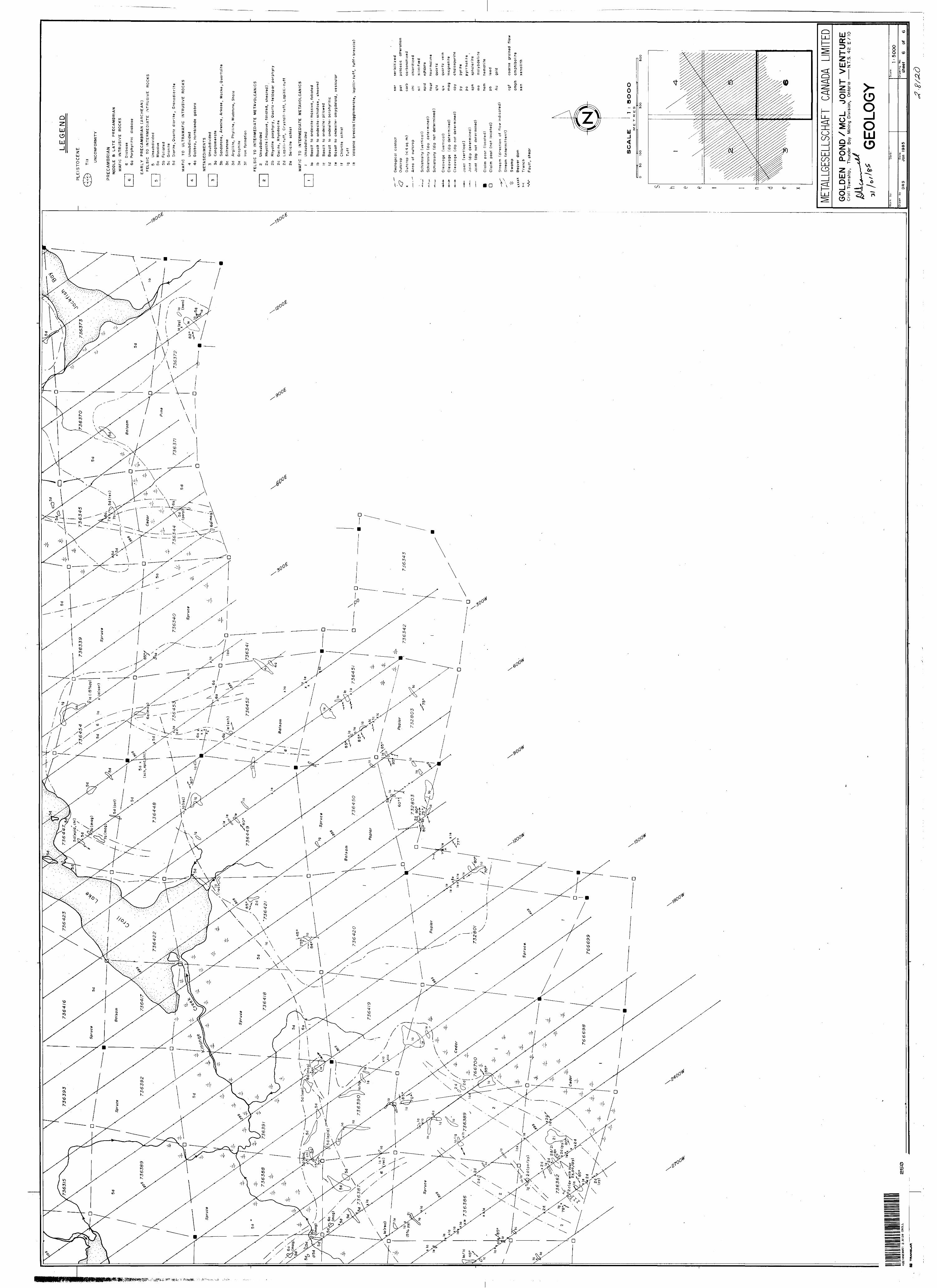
LE
GE
ND
PLE
IST
OC
EN
E
Till
UN
CO
NFO
RM
ITY
PR
EC
AM
BR
IAN
MID
DLE
S
LA
TE
P
RE
CA
MB
RIA
N
MA
FIC
IN
TR
US
IVE
R
OC
KS
6 D
iaba
se6a
P
orp
hyr
itic
diab
ase
42E
10N
E80
51
2.8
12
0
CR
OLL
RB
T
RA
NS
UU
t
EA
RL
Y
PR
EC
AM
BR
IAN
(A
RC
HE
AN
) F
ELS
fC
TO
INT
ER
ME
DIA
TE
IN
TR
US
IVE
R
OC
KS
5 U
nsub
divi
ded
5a
Mas
sive
5b
Fo
liate
d5c
G
rani
te5d
D
iorit
e , Q
uart
z d
iorite
, G
ran
od
iorite
MA
FIC
T
O
ULT
RA
MA
FIC
IN
TR
US
IVE
R
OC
KS
4 U
nsub
divi
ded
4a
Ga
bb
ro,
Hor
nble
nde
gabb
ro
ME
TA
SE
DIM
EN
TS
3 U
nsub
divi
ded
3a
Con
glom
erat
e3b
S
ands
tone
, A
ren
ite,
Ark
ose
, W
acke
, Q
ua
rtzi
te3c
S
iltst
one
3d
A
rgill
ite,
Ph
ylli
te,
Mud
ston
e, S
ha
le
3e
Gra
phite
3f
Iron
form
atio
n
FE
LS
IC
TO
INT
ER
ME
DIA
TE
M
ET
AV
OLC
AN
ICS
2 U
nsub
divi
ded
2a
Rhy
olite
(m
assi
ve,
folia
ted,
shea
red)
2b
Rhy
olite
porp
hyr
y, Q
ua
rtz-f
eld
sp
ar
porp
hyr
y2c
D
acite
, R
hyod
acite
2d
La
pill
i-T
uff
, C
r ysta
ll-tu
ff,
Lapilli-t
uff
2e
Se
rici
te
schi
st
MA
FIC
T
O
INT
ER
ME
DIA
TE
M
ET
AV
OL
CA
N I
CS
l U
nsub
divi
ded
la
Bas
alt
to
ande
site
; m
assi
ve,
folia
ted
Ib
Bas
alt
to
an
de
site
; sc
hist
ose,
sh
eare
dle
B
asal
t to
an
desi
te :
pillo
wed
Id
Bas
alt
to
ande
site
; porp
hyr
itic
le
Bas
alt
to
ande
site
--
amyg
dalo
id,
vesi
cula
r
If
Chl
orite
sc
hist
lg
Tu
ff
in
Vol
cani
c b
recc
ia (
ag
glo
me
rate
, la
pill
i- t
uff
, tu
ff-
bre
ccia
)
Q xxxx
x x
Geo
logi
cal
cont
act
Out
crop
Out
crop
^4 s
q. m
)
Are
a of
o
utc
rop
Sch
isto
sity
(vert
ical)
Sch
isto
sity
(di
p dete
rmin
ed)
Sch
isto
sity
(d
ip
not
dete
rmin
ed)
Cle
avag
e (v
ert
ical)
Cle
avag
e (d
ip
dete
rmin
ed)
Cle
avag
e (d
ip
not
dete
rmin
ed)
Join
t (v
ert
ical)
Join
t (d
ip
de
term
ine
d)
Join
t (d
ip
not
dete
rmin
ed)
Cla
im
post
(loca
ted)
Cla
im
post
(n
ot
loca
ted
)
Str
eam
(d
irect
ion
of
flow
indic
ate
d)
Str
eam
(in
term
itte
nt)
Sw
amp
Bea
ver
dam
Tre
nch
Fa
ult,
sh
ear
ser
serici
tized
pot
pota
ssic
a
ltera
tion
carb
ca
rbon
atiz
ed
chl
chlo
ritiz
ed
sil
sili
cifie
dep
id
e prid
e t e
tour
tourm
alin
e
qtz
quart
z
q.v.
quart
z ve
in
mag
m
ag
ne
tite
cpy
chalc
opyr
ite
py
pyr
ite
po
pyrr
ho
tite
sph
sph
ale
rite
mo
mo
lyb
de
nite
hem
h
em
atit
e
pb
lead
Au
gold
cgf
coar
se
grai
ned
flow
amph
am
phib
olit
exe
n xe
no
lith
SC
AL
ES
OO
OM
ET
RE
S
O
50
!0
03O
O500
META
LLGE
SELL
SCHA
FT
CANA
DA
LIMITE
DG
OLD
EN
P
ON
D/M
CL
JO
INT
VE
NT
UR
EC
roll
Tow
nshi
p,
Thun
der
Bay
M
inin
g D
ivis
ion,
O
ntar
io —
——
N.T
.S.
42
E X
10
GEO
LOG
YW
ork
byD
ate:
Dra
wn
byD
RS
Dat
e,Ja
n
19
85
Sca
le-
'50
0O
No
shee
t 6
of
6