la pdf version - the wildlife trusts living... · functioning natural world – is essential for...
TRANSCRIPT

Living landscapesA call to restore the UK’s battered ecosystems, for wildlife and people

2LIVING LANDSCAPESA CALL TO RESTORE THE UK’S BATTERED ECOSYSTEMS FOR WILDLIFE AND PEOPLE
To adapt to climate change, the UK’s wildlife will need to move along ‘climate corridors’ up and down the country, or to shadier slopes or cooler valleys. Wildlife has done it all
before, after the last ice age, but this time the change is faster and there are unexpected obstacles: cities, motorways and expanses of hostile countryside.
If we don’t give our wildlife enough room to manoeuvre, a collapse in biodiversity is inevitable. For decades we have been slowing the decline in biodiversity by protecting small oases of wildlife as an emergency measure. Now, in the face of climate change, it is essential that we link these oases and restore our ecosystems and natural processes at a speed and on a scale that we would once have felt was impossible.
Different parts of the UK will need to take different approaches, depending not only upon natural habitats but upon local social and economic needs. And change on this scale needs deep-rooted support across many constituencies.
Driven by local people and aspirations, The Wildlife Trusts play a leading role not just in developing the vision but in mustering the support that can allow communities to drive their own change. We do this by working closely with community groups, businesses, land managers and local authorities on landscape-scale projects around the UK.
We look to the Government to show leadership also. The Government needs to be brave enough to remove the obstacles preventing our wildlife from adapting; to buy more time by resolving to reduce our greenhouse gas emissions; and to show political will by serious investment in rebuilding biodiversity on a landscape scale. We need to create our Living Landscape now. Our window of opportunity will soon close.
Stephanie Hilborne, chief executive,
The Wildlife Trusts

3LIVING LANDSCAPESA CALL TO RESTORE THE UK’S BATTERED ECOSYSTEMS FOR WILDLIFE AND PEOPLE
CONTENTSWhy big is beautiful 4
The science behind landscape-scale nature conservation 6
The Wildlife Trusts’ record in large-area conservation 11
The key challenges, by landscape type 12
What needs to happen now? 18
Case studies of landscape-scale restoration projects 20
Rebuilding Biodiversity 21A science-based vision for wildlife in the South West of EnglandSimon Brenman Director of Regional Programmes, South West Wildlife Trusts
On Trent 23Benefiting wildlife, heritage and people in parishes along the Trent valleyRuth Needham OnTrent project officer, The Wildlife Trusts
A Vision for Tame Valley 26A project to conserve wetland wildlife in a severely degraded landscapeBeth Gardner Director of conservation, Warwickshire Wildlife Trust
The Pumlumon Project 29A whole landscape in Montgomeryshire – people, place and natureEstelle Bailey Chief executive officer, Montgomeryshire Wildlife Trust
The Idle Valley Project 36A plan for sustainable wildlife, flood reduction and a better local economyCharles Langtree Head of estate management and development, Nottinghamshire Wildlife Trust
Rebuilding Dorset’s Biodiversity 40Restoring Dorset’s fragmented habitats for wildlife and peopleImogen Davenport Head of conservation, Dorset Wildife Trust
Black Country Living Landscape 44A plan for landscape-scale conservation among a million peopleNeil Wyatt Chief executive, The Wildlife Trust for Birmingham and the Black Country
The Great Fen Project 50Creating a wonderful wetland with huge social and economic benefitsChris Gerrard Great Fen project manager, The Wildlife Trust for Beds, Cambs, Northants and Peterborough
The West Weald Landscape Project 55Working towards a naturally functioning landscape for wildlife and peopleRich Howorth West Weald landscape project manager, Sussex Wildlife Trust
Landscape-Scale Conservation on the Isle of Eigg 60A project driven and directed by the local communityStuart Brooks Head of conservation, Scottish Wildlife Trust

4LIVING LANDSCAPESA CALL TO RESTORE THE UK’S BATTERED ECOSYSTEMS FOR WILDLIFE AND PEOPLE
The Wildlife Trusts’ vision is an environment rich in wildlife for everyone. We see it as an essential element in human wellbeing, and ultimately vital for our own survival. Whether for clean air, food, clear water, an equitable climate or the marvel of a natural landscape, we rely entirely on a healthy, functioning environment. Signified by abundant wildlife and wildlife habitats, it should exist everywhere, and not be limited to a few special places. It is everyone’s right.
Wildlife is also important for its own sake; it is better to live in a world where nature is highly valued, independently of its material or functional use to humans. By ‘nature’ we mean something not under direct human control. For their own sanity, people need contact with the ‘wild’, or at least with the apparently natural. This contact could range from a complete wilderness experience through to the appreciation of a robin in a small patch of untamed vegetation inside a city. It is different from, but complementary to, contact with plants and animals in a controlled environment.
We believe that an ecologically diverse landscape – a functioning natural world – is essential for people, for planet and for sustainability.
Traditional nature conservationNature conservation in Britain has traditionally focussed on the preservation of special sites. This is both necessary and urgent, but it is less than the basic minimum required to conserve nature in the long term. This site-based approach provides the following:
Key benefits:● It ensures that, within limits (see p6), we maintain the
best of what we have;● It encourages the valuing of key assets;● It promotes the concept of sustainable management in
sensitive areas, where people take responsibility for conservation and management.
Key disadvantages:● It can place nature in a ghetto, with wildlife limited to
special areas, to be enjoyed by the privileged;● It can promote the view that nature is only where we
allow it, and must be controlled and restricted;
Why big is beautifulTony Whitbread Chief executive, Sussex Wildlife Trust
Species-rich grassland at Derbyshire Wildlife Trust’s Priestcliffe Lees reserve. Nature belongs everywhere, not just in a few special places

5LIVING LANDSCAPESA CALL TO RESTORE THE UK’S BATTERED ECOSYSTEMS FOR WILDLIFE AND PEOPLE
● It may encourage a Disney-esque view of ‘good’ and ‘bad’ nature: we allow the ‘right’ and disallow the ‘wrong’;
● It encourages a prescriptive view of nature, where narrow objectives are set for it, and it is then controlled and manipulated to deliver;
● It can allow wildlife to be separated from a wider environmental sustainability agenda: Nature may be allowed in special places, but the ‘real world’ of wider sustainability issues holds sway over the vast majority of the landscape;
● It can separate nature from natural processes – making nature conservation a separate subject from climate, nutrient cycling, hydrology and so on.
Landscape scale: the future of nature conservationLandscape-scale nature conservation is not simply about bigger special sites. It is a different philosophy that requires us to:● Understand nature; appreciate it and work with it;● Understand the processes that give rise to habitats, and
provide conditions suitable for the species;● Understand how these processes can be influenced or
copied;● See wildlife and nature as synonymous with natural
processes, and the ecological functioning of the area, region or planet;
● Understand the interaction between cultural and natural landscape.
The core principleTake an example: imagine a wet meadow, important for wildlife, in a river valley.
A traditional habitat management approach would aim to bring that habitat into favourable condition through appropriate management – maybe expanding it by including neighbouring areas as a contribution to Biodiversity Action Plan targets. This would benefit wildlife, and those who are interested in wildlife.
A landscape-scale or landscape ecology approach would address the processes that drive the ecological interest of the meadow – hydrology and grazing – and look at how these functioned in the whole valley. It is a step-change, from managing the meadow to influencing the processes that work on the whole valley.
Working in this way would improve a larger area for wildlife. But it would also improve the ecological functioning of the valley, with spin-off benefits such as better flood management and aquifer recharge. And this wouldn’t just interest nature-lovers. It would interest everybody.
In shortTo recreate genuine living landscapes, we need to embrace this approach:● Move from dominators and controllers of nature to
appreciators and influencers of nature;● Move from nature as special interest to nature as
providing our living conditions – locally, regionally and globally;
● Move from a situation of nature in boxes to nature in the neighbourhood and nature in the landscape.
What is a landscape?Most descriptions of landscape have two themes in common (Gutzwiller 2002): 1. Landscapes are composed of multiple patches
(habitats) and 2. The variety of patches creates diversity in an area.
A landscape may therefore be considered a level of ecological hierarchy above habitat.
Although we often refer to a landscapes approach as being large-scale, this need not necessarily be the case. A wood managed as a wood (whatever its size) is a habitat approach. A forest with a diversity of patches, wooded and un-wooded, that interact, merge and change over time, is a landscape approach.
What is landscape ecology?There are three different approaches that help define landscape ecology:1. Landscape ecology as a holistic, problem-solving
approach to resource management, integrating aspects of human activity with their environmental consequences
2. Landscape ecology as local ecology writ large: a diversity of habitat patches over large areas, and with geographically defined conservation efforts
3. Landscape ecology as the causes and consequences of spatial patterns in the environment.
Different cases from around The Wildlife Trusts tend to emphasise one or other of these themes.

6LIVING LANDSCAPESA CALL TO RESTORE THE UK’S BATTERED ECOSYSTEMS FOR WILDLIFE AND PEOPLE
Why step outside designated local areas?The policy of protecting remaining habitat patches through designations such as SSSIs and Wildlife Sites has achieved much to date, but is unlikely to sustain our wildlife in the long term.
Within designated sites, most species of higher plants and vertebrates are conserved to at least some extent, although lower plants and invertebrates are less effectively represented. However, even the well-conserved species have a questionable future, because many of the sites are not viable, either ecologically or economically.
Many protected sites in the UK are compromised by their small size, isolated geographic position, or their sub-optimal quality. This is further exacerbated by the threat of climate change. The conservation literature in England is full of accounts illustrating how the richness and abundance of Britain’s biodiversity continues to decline under the current protected area system and the application of existing conservation tools.
Conservation at a landscape-scale focuses on restoring the underlying ecological functions that maintain species populations within the habitats of concern. By increasing habitat patch size, quality and concentration in the landscape, and the ecological permeability of intervening land, we can help species to ‘percolate’ through the countryside, increasing immigration and emigration rates, and reducing population isolation and vulnerability.
While the landscape approach in no way dispenses with the need for intervention management, it does offer the prospect of less artifi cial and costly ‘propping up’ of patches of habitat which are currently at risk of losing species to a hostile surrounding landscape. It therefore potentially offers much greater fl exibility in the management needed to maintain these larger agglomerations of habitat.
How big is ‘big’?While the landscape-scale approach involves moving away from small sites, a question remains as to how we defi ne an area within which landscape-scale conservation will take
The science behind landscape-scale nature conservationHarry Barton Wiltshire Wildlife Trust
Baston Fen in Lincolnshire – too small to survive as it is, but not as part of an 800 hectare wetland

7LIVING LANDSCAPESA CALL TO RESTORE THE UK’S BATTERED ECOSYSTEMS FOR WILDLIFE AND PEOPLE
place. At one extreme, identifying no boundaries recognises the way nature works in practice, but it makes practical action backed up by effective policy diffi cult to implement. In some instances, self-defi ned areas naturally present themselves, such as a river catchment or a small and well-defi ned range of hills. But in much of lowland Britain it is diffi cult to identify such natural boundaries. Various approaches have been used instead:● The natural extent of geological or topographical features; ● Historical reference, for example the former range of a
habitat type, such as the forests of the Sussex Weald;● Areas of opportunity, such as the Cotswold Water Park,
where gravel extraction provides extensive habitat creation opportunities;
● Ecological viability models, which seek to defi ne areas based on the ecological needs of one or more habitats and their constituent species.
The science of viabilityThe benefi ts of landscape-scale conservation will only be felt if we can be confi dent that we are focusing on a suffi ciently large area. If we select landscapes on the basis of natural boundaries, such as river catchments or geological features, they are likely to be large enough to accommodate even the most area-demanding species. But if we start from the basis of trying to defi ne the smallest areas we need, then we need to rely on science.
The science of viability is fraught with uncertainty and controversy, and a ready set of rules for defi ning what is (and is not) viable does not exist. Yet it is important that the agenda for wildlife habitat expansion starts from as sound a theoretical basis as possible.
In addressing the diffi cult issue of long-term population viability, the ingredients at least are clear. Viability depends on the interplay of three factors:● Habitat quality;● Patch size;● Degree of isolation in the landscape.
A strategy which ignores any of these three factors risks long-term failure.
To support healthy populations, habitat needs to provide the quality or conditions required by its constituent species (vegetation structure, food sources, microclimate etc). Patches of habitat need to be of suffi cient size to contain all necessary successional stages, and need to be close enough to other patches, without insurmountable barriers in between, to allow for dispersal and colonisation.
In much of the UK we are used to managing small sites for nature conservation, often surrounded by a landscape
hostile to wildlife. Maximising the quality of such fragments is essential. But as the size of an area that is managed for wildlife increases, the need for the precision approach to quality lessens. At the largest scale, successional stages of habitat shift around the landscape in a natural dynamic pattern, and the distribution of species and biodiversity hotspots with them.
Calculating specifi c examplesIf a habitat unit is to be self-suffi cient in all its typical species, then all structural types and stages, and hence the niches they provide, must be present all the time.
As a fi rst step to designing viable landscapes for wildlife we need to establish how large a patch of a given habitat needs to be to maintain its full complement of biodiversity over the long term. One approach to answering this question is to use the concept of Minimum Dynamic Area.
Minimum Dynamic Area (MDA, Pickett & Thomson 1978)‘The smallest area with a natural disturbance regime, which maintains internal re-colonization sources and hence minimizes extinction.’
In other words, the smallest area required for a species or habitat to sustain itself independently without intervention. Methods to establish MDA include:
Core area Particularly for woodland, habitat fragmentation leads to an increase in the ratio of habitat edge to area. As a result species populations are not only sub-divided, but are increasingly exposed to environmental impacts from outside their immediate patch, such as temperature fl uctuation and loss of humidity, or impacts associated with intensive land use such as pesticide drift. A core area’s species composition is typically different from the edge.
Wild service is an infrequent tree in ancient woodland
8LIVING LANDSCAPESA CALL TO RESTORE THE UK’S BATTERED ECOSYSTEMS FOR WILDLIFE AND PEOPLE
The core area of a patch of woodland cannot simply be defi ned by its edge-to-area ratio. It is also a product of its shape, size, and the distance to which edge effects penetrate. Peterken has suggested that, assuming patches are roughly circular and that edge effects penetrate up to 200 metres, 50 hectares is the minimum size that will guarantee at least a portion of core (as well as edge) habitat.
Disturbance regimesIf a habitat is subject to highly disruptive disturbance events, then to be viable a given unit of that habitat needs to be considerably larger than the size of the largest predictable disturbance event.
For example, a small patch of heathland would be subject to enormous fl uctuations in structure and composition over time if all stages of heathland growth were to be wiped out in a single fi re event. In Dorset and Cornwall the largest fi re event which experts can recall is of the order of 150 hectares. By implication, heathland patches need to be at least as large as this to be viable in the long term.
Most area-demanding speciesThis approach assumes the the size of a functional unit of a habitat is determined by the area needed to support a stable, breeding population of its most area-demanding species.
Research into the area requirements of the stone curlew suggests that, in good quality habitat with a high density, 11-12 pairs may occupy two to four square kilometres. In poorer habitat, with a lower density, there may be ten pairs in over 11 square kilometres. Taking a sustainable population to be 25 breeding pairs, then the population would require some 500 hectares of good quality habitat, or 2,750 hectares of poorer habitat. A mean area between these two extremes would thus be approximately 1600 ha.
Observation of actual sitesin many instances the data to defi ne area requirements of particular species, or disturbance regimes, is simply not available. Observation of well-known sites, and consideration of how stable they appear in terms of maintaining their complement of species over time, may be the best available alternative.
Metapopulation dynamicsIn some species (for example butterfl ies), population size and structure is not only determined by the size of individual habitat patches. Sub-populations establish and fail in habitat patches regardless of other parameters, and the continuity of the greater (or meta-) population depends on dispersal from neighbouring sub-populations into newly
vacant patches.In some cases individual patches may be large enough to
support multiple sub-populations, with dynamic exchange between them. In many others, metapopulation species success is determined more by landscape context than by individual patch size.
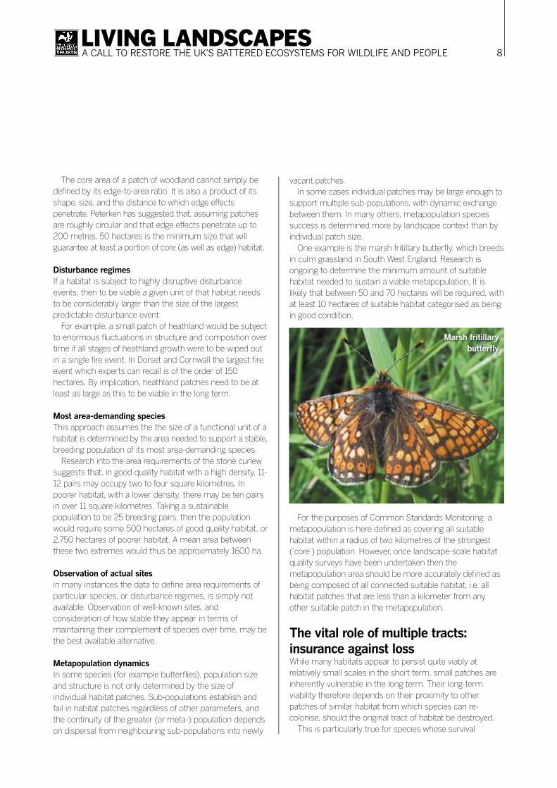
One example is the marsh fritillary butterfl y, which breeds in culm grassland in South West England. Research is ongoing to determine the minimum amount of suitable habitat needed to sustain a viable metapopulation. It is likely that between 50 and 70 hectares will be required, with at least 10 hectares of suitable habitat categorised as being in good condition.
For the purposes of Common Standards Monitoring, a metapopulation is here defi ned as covering all suitable habitat within a radius of two kilometres of the strongest (‘core’) population. However, once landscape-scale habitat quality surveys have been undertaken then the metapopulation area should be more accurately defi ned as being composed of all connected suitable habitat, i.e. all habitat patches that are less than a kilometer from any other suitable patch in the metapopulation.
The vital role of multiple tracts: insurance against lossWhile many habitats appear to persist quite viably at relatively small scales in the short term, small patches are inherently vulnerable in the long term. Their long-term viability therefore depends on their proximity to other patches of similar habitat from which species can re-colonise, should the original tract of habitat be destroyed.
This is particularly true for species whose survival
Marsh fritillary butterfl y
9LIVING LANDSCAPESA CALL TO RESTORE THE UK’S BATTERED ECOSYSTEMS FOR WILDLIFE AND PEOPLE
depends on meta-population dynamics, or are considered to be slow colonisers of new habitat. Thus, even for a patch of habitat as large as the target set for the MDA, we need to ensure that multiple tracts are conserved.
Unfortunately, little theoretical or empirical scientific research addresses this subject. Rebuilding Biodiversity in the South West (p21) used the work of Cox et al (1994), who, in developing a conservation plan for Florida, recommended that ten populations of a species should be conserved. This is based on an assumption that each population has a 30 per cent chance of persistence and therefore the protection of ten populations would give a greater than 90 per cent probability of at least one population persisting.
Thus we would need ten patches of habitat, each large enough to accommodate the most area-demanding species, in order for that species to survive in the long term. But more research is needed.
Fitting landscape-scale conservation areas into existing featuresIn most cases, and especially in lowland areas, it will not be possible to establish giant nature reserves. Habitat patches
will need to exist alongside, around and in between villages, agricultural land and other land uses. The goal must be to ensure a minimum degree of interconnectedness between patches.
Research into woodland shows that the key factor in allowing species to migrate between woodland fragments is the presence of high quality semi-natural habitat in the intervening land. The intervening habitat does not have to be woodland, but can be heath, meadow, mire or any other habitat that typically occurs in association with woodland in the landscape. This demonstrates the importance of recognising that most habitats occur in the form of mosaics, and that we should be planning to rebuild these mosaics, rather than just the one preferred habitat type.
The question remains as to whether there is a minimum level of coverage associated with viability and, if so, what that level is. Buckley and others have used computer-generated models to give indications of the minimum coverage needed to ensure a sufficient degree of interconnectivity. Models based on the random distribution of blocks in a theoretical landscape suggest that, at somewhere between 50 and 60 per cent coverage, all blocks are adjacent to another. Rebuilding Biodiversity in the South West (p21) used a figure of 50 per cent to help
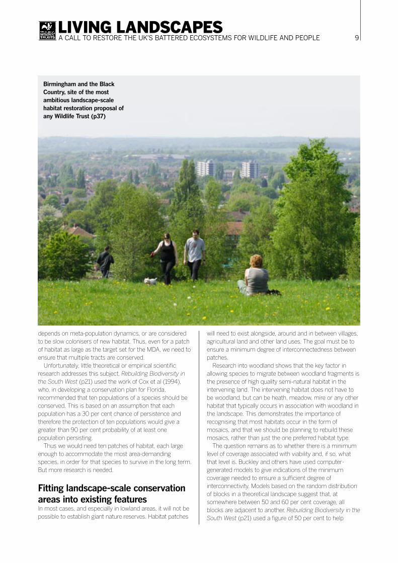
Birmingham and the Black Country, site of the most ambitious landscape-scale habitat restoration proposal of any Wildlife Trust (p37)
10LIVING LANDSCAPESA CALL TO RESTORE THE UK’S BATTERED ECOSYSTEMS FOR WILDLIFE AND PEOPLE
construct ideal landscapes for wildlife. Recent research suggests that the relationship between viability and landscape coverage is likely to be more complex. More research is needed here.
Selecting the right areasWhile the combination of quality, size and landscape context is vital in setting the framework for designing ideal landscapes for conservation purposes, it is equally important to have a framework for selecting appropriate sites on the ground.
Two particularly important considerations are:
Building around existing high-quality clustersIt is crucial that the areas chosen contain clusters of good quality fragments from which habitat can expand and species populations grow.
Building a resilient landscapeIn a landscape of small, isolated habitat fragments, each fragment is effectively a sink. Populations of species may persist there for a time, but are prone to local extinction and will only be re-colonised by chance if a population exists in a neighbouring fragment. By expanding and reconnecting fragments, we can create sources – areas with self-sustaining populations of species from which re-colonisation of the surrounding landscape can occur.
Landscape-scale conservation to help species survive climate changeThis is a crucial factor. Much of this paper focuses on the creation of corridors between patches of semi-natural habitat. However, linking patches of habitat with corridors can only be part of the answer. This is because only the most mobile species will be able to shift their latitude, altitude or aspect rapidly enough to keep pace with shifts in their climate-space.
Altitudinal corridors are likely to be more effective than latitudinal ones, because temperature drops more quickly with altitude than with latitude. But in much of the UK their creation is not possible. A more pragmatic and effective response, in the medium term at least, is to strengthen and extend nature’s best remaining refuges. Current scientific thinking on species response to global climate change is that the majority of species will try and remain at their current location for as long as possible, or will shift their habitats minimally.
The sustainability of species populations in a given landscape in the face of climate change will be influenced by the range of ecological niches offered across the area. A landscape that occupies a range of altitudes and offers a range of aspects, hydrologies, and vegetation structures will present more opportunities for species to shift their locations than one that is highly uniform in these respects.
11LIVING LANDSCAPESA CALL TO RESTORE THE UK’S BATTERED ECOSYSTEMS FOR WILDLIFE AND PEOPLE
As the rest of this report shows, The Wildlife Trusts play a leading role in landscape-scale projects all over the UK, from city to mountain top to seashore. The following section (pages 12-17) features six key landscape types to show the challenges that need to be met and the benefi ts that can be delivered. These benefi ts are not just environmental, but social and economic. Government should lead in setting policies and providing incentives (pages 18-19). In the meantime, The Wildlife Trusts are taking a lead locally.
LeadershipA step-change in our land use practice and policy requires local as well as national leadership. Wildlife Trusts around the UK are giving local authorities, businesses and community leaders the confi dence to do what they know is right for their area and their grandchildren – to be optimistic, to make brave decisions and take bold steps towards a better future.
KnowledgeThe examples overleaf show how we can work with nature rather than against it. To do this means understanding the local ecology, wildlife, water and soils that make up the landscape, and also local economic, cultural and social needs. The Wildlife Trusts are driven and owned by people with unrivalled knowledge of their local area, past and present. This must inform our future.
Four decades of partnershipSince the 1960s, local people have come together through their Wildlife Trusts to save precious places for wildlife. They have given advice on land management, taken on nature reserves and infl uenced planning decisions. All this time we have worked with schools, community groups, statutory agencies, local authorities, landowners and businesses to inspire people about wildlife. We are perfectly placed to unite with our partners behind major new initiatives that bring together all this work.
The Wildlife Trusts’ record in large-area conservationStephanie Hilborne Chief executive, The Wildlife Trusts
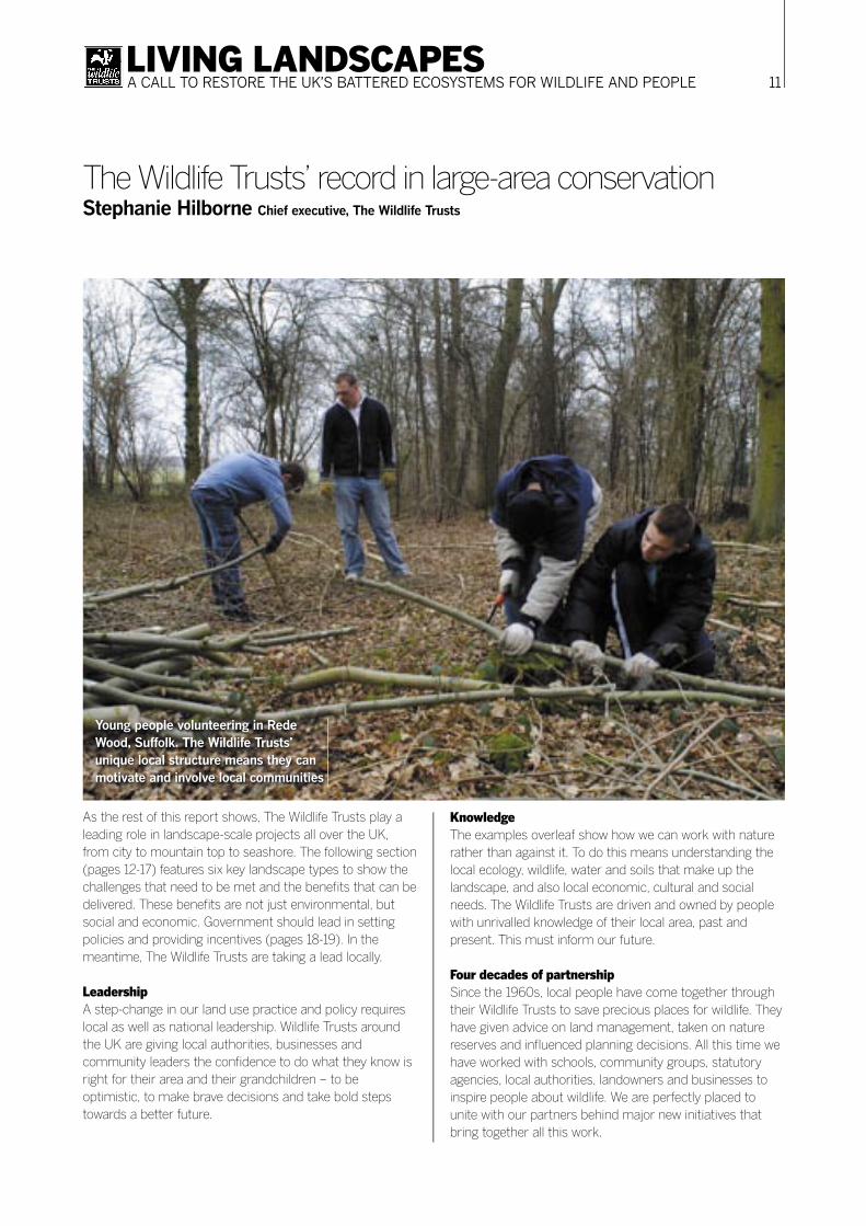
Young people volunteering in Rede Wood, Suffolk. The Wildlife Trusts’ unique local structure means they can motivate and involve local communities

12LIVING LANDSCAPESA CALL TO RESTORE THE UK’S BATTERED ECOSYSTEMS FOR WILDLIFE AND PEOPLE
WoodlandAncient woodland is perhaps our richest wildlife habitat. It once cloaked most of Britain, but we now have one of the lowest coverage levels in Europe. Half our ancient woodland has been lost since the 1940s.
Woodland plays a vital role in recycling carbon dioxide and water vapour and, like bogs and wetlands, regulates water fl ow into rivers. It’s also highly valued by local people for recreation.
While we continually hear of the threats to forests worldwide, there are stunning examples of woodland being recreated, or regenerating naturally. Much of North East USA was once farmland, but abandonment in the early 1900s allowed the trees to return. Some of that forest is now protected in national parks.
The main challengesUK woodland is often heavily modifi ed or managed, and plantations typically lack the structural and species diversity of ancient woodland. Traditional coppicing, pollarding and grazing can be benefi cial, but they are now rarely economically viable.
Left naturally, lowland woodland can return quite easily. However, many people see large areas of scrub as untidy. In upland areas, regeneration is slower and often hampered by grazing, impoverished soils and a lack of seed source. Grants like the English Woodland Grant Scheme can help,
but there is insuffi cient funding.Natural woodland is typically a mosaic of different habitat
types, including old stands of high forest, scrub areas, and forest glades. Allowing natural forest landscapes to re-establish means looking differently at the landscape, and the processes at work within it. In upland areas, Wildlife Trusts are working with landowners to restrict or exclude grazing from large areas around remnants of woodland. Meanwhile, in lowland areas, we are supporting landowners and communities to remove fencing around woodland, allow areas to scrub up and encourage grazing animals to roam more freely.
One example of Wildlife Trust actionThe Low Weald of West Sussex and south Surrey is a diverse landscape containing some of England’s best ancient woodland, as well as other wildlife-rich habitats. Sussex Wildlife Trust is leading a project to enhance, create and reconnect habitat here within an area of 93 square miles. Local communities and farmers have agreed a shared vision for the project area.
The aim is a landscape akin to the original forest, with glades, pastures and wetlands as well as dense woods. Large, free-roaming animals will graze in core woodland areas and the natural processes of decomposition and regeneration will be encouraged. Between these core areas the Trust is working with farmers to encourage them to farm more sensitively for wildlife.
The key challenges, by landscape typeHarry Barton Wiltshire Wildlife Trust
Forests are as useful as they are beautiful, but their restoration depends on people understanding that they form part of a bigger mosaic
13LIVING LANDSCAPESA CALL TO RESTORE THE UK’S BATTERED ECOSYSTEMS FOR WILDLIFE AND PEOPLE
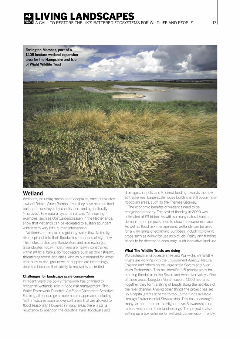
WetlandWetlands, including marsh and floodplains, once dominated lowland Britain. Since Roman times they have been drained, built upon, destroyed by canalisation, and agriculturally ‘improved’. Few natural systems remain. Yet inspiring examples, such as Oostvardersplassen in the Netherlands, show that wetlands can be recreated to sustain abundant wildlife with very little human intervention.
Wetlands are crucial in regulating water flow. Naturally, rivers spill out into their floodplains in periods of high flow. This helps to dissipate floodwaters and also recharges groundwater. Today, most rivers are heavily constrained within artificial banks, so floodwaters build up downstream, threatening towns and cities. And as our demand for water continues to rise, groundwater supplies are increasingly depleted because their ability to recover is so limited.
Challenges for landscape scale conservationIn recent years the policy framework has changed to recognise wetlands’ role in flood risk management. The Water Framework Directive, AMP and Catchment Sensitive Farming all encourage a more natural approach, including ‘soft’ measures such as overspill areas that are allowed to flood seasonally. However, in many areas there is still a reluctance to abandon the old-style ‘hard’ floodwalls and
drainage channels, and to direct funding towards the new soft schemes. Large-scale house building is still occurring in floodplain areas, such as the Thames Gateway.
The economic benefits of wetlands need to be recognised properly. The cost of flooding in 2000 was estimated at £3 billion. As with so many natural habitats, demonstration projects need to show the economic case. As well as flood risk management, wetlands can be used for a wide range of economic purposes, including growing crops such as willow for use as biofuels. Policy and funding needs to be directed to encourage such innovative land use.
What The Wildlife Trusts are doingWorcestershire, Gloucestershire and Warwickshire Wildlife Trusts are working with the Environment Agency, Natural England and others on the large-scale Severn and Avon Vales Partnership. This has identified 18 priority areas for creating floodplain in the Seven and Avon river valleys. One of these areas, Longdon Marsh, covers 4,000 hectares. Together, they form a string of beads along the necklace of the river channel. Among other things the project has set up a capital grants scheme to top up the funds available through Environmental Stewardship. This has encouraged many farmers to enter the Higher Level Stewardship and restore wetland on their landholdings. The project is also setting up a box scheme for wetland, conservation friendly
Farlington Marshes, part of a 1,105 hectare wetland expansion area for the Hampshire and Isle of Wight Wildlife Trust

14LIVING LANDSCAPESA CALL TO RESTORE THE UK’S BATTERED ECOSYSTEMS FOR WILDLIFE AND PEOPLE
UplandsThough often degraded by deforestation and overgrazing, uplands contain our greatest variety of habitats, and are vitally important as places to get away from the bustle of everyday life. As well as controlling erosion and regulating water supply, upland forests and peat bogs play a vital role in regulating carbon dioxide. The peaty soils hold huge amounts of carbon in partially decomposed organic material. Drier, thinner soils that have been drained or planted with conifers lose much of this carbon to the atmosphere. What are the main challenges?Overgrazing by sheep was the greatest threat, but changes in agricultural payments are reducing this to beneficial levels.
Wildlife Trusts are working with upland communities to reduce cultural and aesthetic concerns about withdrawing
farming and restoring upland habitats. Reducing grazing need not mean the end of farming; it simply means farming differently.
However, more needs to be done. Upland farmers and land managers need to be rewarded for flood control benefits felt downstream, and for the climate benefits of land management that stores more carbon.
One example of Wildlife Trust actionEigg in Scotland (see report by the Scottish Wildlife Trust, p 53) is an outstanding case of landscape-scale conservation driven by local people. With the help of the Scottish Wildlife Trust and others, the island is now owned by the Isle of Eigg Heritage Trust. The forest is protected from overgrazing, and the raised bog is recovering from drainage and conifer planting. The islanders themselves, properly trained and equipped, completed this work.
Good husbandry in the uplands has a huge impact on water management and carbon absorption

15LIVING LANDSCAPESA CALL TO RESTORE THE UK’S BATTERED ECOSYSTEMS FOR WILDLIFE AND PEOPLE
Coastal habitatsUK coasts are among the most varied and scenic in the world. The richest parts are lowland mudfl ats, marshes and estuaries, with their birdlife, wild fl owers, and nursery grounds for sea life. They act as fl oodplains, carbon sinks, and fi lters for estuaries. Yet vast swathes have been drained, ploughed up, built upon or walled off from the sea. Climate change predictions suggest devastating coastal fl oods could occur within a few decades. This means these habitats have an increasingly important role to play in absorbing marine fl oodwaters.
What are the main challenges?Managed coastal realignment requires diffi cult, strategic decisions to abandon or dismantle defences. Wildlife Trusts around the UK are working with local communities to
achieve a shared vision and sense of purpose. Grants are needed to encourage farmers to leave areas for the sea to reclaim.
One example of Wildlife Trust actionIn 2002, Essex Wildlife Trust breached the sea wall at Abbotts Hall farm on the Blackwater estuary to create 81 hectares of salt marsh and grazing marsh. Funded by the Heritage Lottery Fund, WWF (UK), Environment Agency and Natural England, it was the largest coastal re-alignment in Europe. The new marshes quickly established a wide range of plants used by many invertebrates and coastal birds. They also support three commercial fi sh species and trial oyster beds. The main farm still grows arable crops where Essex Wildlife Trust demonstrates a wild range of wildlife-friendly farming methods.
Abbots Hall Farm, where in 2002 Essex Wildlife Trust breached the sea wall to make the biggest coastal realignment in Europe

16LIVING LANDSCAPESA CALL TO RESTORE THE UK’S BATTERED ECOSYSTEMS FOR WILDLIFE AND PEOPLE
Lowland grasslandLowland grassland, including chalk downland and hay meadow, includes some of the richest areas for wildlife in the UK. But because these habitats often occur in areas well suited to modern, intensive agriculture, all but the steepest, wettest or most inaccessible sites have been lost – 98 per cent since the 1950s. With a few notable exceptions, such as Salisbury Plain, the surviving sites are small, isolated and fragmented.
Grassland habitats are often associated with culturally important landscapes. The downlands of Wiltshire hold some of the richest concentrations of archaeological sites in Europe. Most of the Areas of Outstanding Natural Beauty (AONBs) of lowland England, from the Cotswolds to the North Downs, are predominantly grasslands, and are among our most treasured and visited landscapes.
What are the key challenges?The fragmentation of much lowland grassland makes it diffi cult to manage with modern agricultural equipment and commercial breeds of cattle. Hay meadows and water meadows in particular need precision management on a small scale, which is not feasible for most hard-pressed farmers. In England, the new Environmental Stewardship scheme helps, but increased higher level grants for restoration are needed to restore the areas that can
reconnect the isolated fragments. Fears over the right of access are another diffi culty in creating new areas of open downland.
Targeting activity on the ground is essential. Wildlife Trusts are working with others to identify and focus effort on the areas with most potential to reconnect habitat. Agricultural payments and other assistance needs to be directed towards these areas, to help fi ll key missing pieces in the jigsaw. These schemes need to be backed up by other capital grants and mechanisms to help farmers operate more effectively, such as machinery rings and cooperative grazing systems.
One example of Wildlife Trust actionWorking with Natural England, and with funding from the Tubney Charitable Trust, the Somerset and Wiltshire Wildlife Trusts are reconnecting grassland habitats on a landscape scale in the Mendip Hills and the Braydon Forest area respectively. As well as targeting Environmental Stewardship advice, these long-term, multi-partner projects aim to make locally-harvested wild fl ower seed and green hay available to farmers, alongside helping to source suitable cattle and machinery.
The Wiltshire Wildlife Trust has also set up its own farm with native cattle and introduced traditional haymaking to manage a network of meadows in the north of the county.
Blakehill Farm, a former miltary
airfi eld now being used by Wiltshire
Wildlife Trust for the UK’s largest
grassland restoration project

17LIVING LANDSCAPESA CALL TO RESTORE THE UK’S BATTERED ECOSYSTEMS FOR WILDLIFE AND PEOPLE
Urban areasThe Wildlife Trusts have been working with people in built-up areas for many years because our towns and cities can be havens for wildlife in an increasingly hostile countryside. Gardens, parks, derelict land, veteran trees, canals and rivers welcome a wide variety of species.
Urban areas provide perhaps the best opportunities for people to encounter nature. Wildlife-rich green space, where people can get away from it all, is widely regarded as crucial to a high quality of life. We can also link wildlife with progressive new building styles and tackling climate change. For example, green roofs can help absorb heavy rainfall and regulate the temperature of buildings, as well as providing wildlife habitat.
The key challengesHuge numbers of houses are expected to be built over the next 25 years, many on urban brownfield sites which can be rich in wildlife. However, developers increasingly see the economic benefits of creating space for nature within new residential areas.
Moreover, in many urban areas there is pressure to remove ‘untidy’ scrub, mow amenity grasslands extremely short, and remove vegetation on ditch banks and verges. But with proper planning and support from local Wildlife
Trusts, carefully designed networks of wildlife-friendly green space can be included in new development (p18). Developers can perform a vital role, funding habitat creation on the back of development, which in turn enhances the quality and value of new buildings. Local authorities can make a huge contribution to wildlife through more sensitive management of open spaces. Local communities are an even more powerful force in managing these areas.
One example of Wildlife Trust action While it may conjure images of endless buildings, Birmingham and the Black Country is in fact one of the UK’s most diverse areas for wildlife, with more rivers and canals than Venice. Alongside a million people live otters, water voles, peregrines, great crested newts, threatened crayfish, and huge numbers of unusual plants.
Capitalising on this hidden richness, the local Wildlife Trust has been working with local authorities and others to achieve a ‘transformation of the environment’, with cross-party and central Government support.
The Trust plans to create strategic ‘multi-use green corridors’, rich in wildlife. These will link the key population centres, key nature reserves and other natural heritage features. Perhaps the most dramatic proposal is a ‘green bridge’ nature reserve linking Dartmouth Park to West Bromwich town centre, flying over its bypass.
By the time these children in Solihull grow up, the city may be more green and pleasant than their parents could imagine
18LIVING LANDSCAPESA CALL TO RESTORE THE UK’S BATTERED ECOSYSTEMS FOR WILDLIFE AND PEOPLE
We are at a turning point in the way we manage our environment. Agriculture is beginning to encompass stewardship of the countryside, planning policy is embracing creative conservation, climate change demands sustainable water management solutions, and we are realising how green surroundings improve our economy, health and wellbeing. We must harness these changes.
Transforming our environment is possible when Government, industry and society work towards a common purpose, with a combination of policy change and incentives. Our rivers, for example, have been dramatically transformed in the last 30 years by an improvement in water quality.
We must use such examples to spur us on. With 50 years of conservation legislation to learn from we need to accelerate our efforts to think bigger and longer term: whole river catchments, robust habitat complexes such as woodland and grassland, entire tracts of upland, and major coastal realignment. We can re-connect the fragmented habitats in our towns and countryside to transform our landscape within a generation.
This is our image of the future; living landscapes that support, provide, inspire and renew. Through them we can halt biodiversity loss, create truly sustainable communities, reconstruct a resilient countryside able to adapt to climate change, and enjoy business that grows as a result of, rather than at the expense of, a healthy environment.
It is a tantalising future that offers a better quality of life for us all. And it is within our grasp if we can embrace the vision, commitment and determination to make it happen.
1. Use the planning system to enhance biodiversity● Map regional and local opportunities
Regional and local planning authorities should identify and map habitat restoration opportunities as a matter of urgency. All planning documents (such as Regional Spatial Strategies and Local Development Frameworks) should include these maps so they can influence land use
What needs to happen now?John Everitt Head of Rebuilding Biodiversity, The Wildlife Trusts
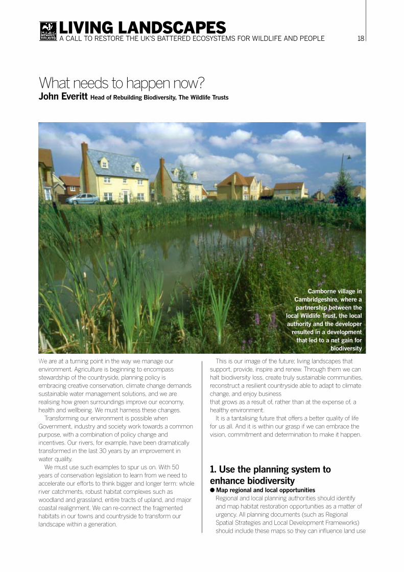
Camborne village in Cambridgeshire, where a partnership between the
local Wildlife Trust, the local authority and the developer
resulted in a development that led to a net gain for
biodiversity

19LIVING LANDSCAPESA CALL TO RESTORE THE UK’S BATTERED ECOSYSTEMS FOR WILDLIFE AND PEOPLE
decisions. Government should support mapping by facilitating a UK-wide spatial framework for landscape-scale conservation.
● Recognise there is a limitMake opportunity maps a key mechanism for helping to establish environmental limits, ensuring that development does not deplete natural resources and processes, and does not threaten the integrity of future landscape-scale developments.
● Inspire local people to improve their quality of lifeUse mechanisms such as community planning and Local Strategic Partnerships to engage and inspire local people about landscape-scale conservation.
● Use local knowledgeThe voluntary sector, Local Record Centres and other experts should help create the opportunity maps. Habitat restoration must be based on the history of local environment, landscapes and wildlife, and significant local social and economic issues.
● Maximise use of the systemContinue to shift planning policy into restoring and creating habitats, and incorporating green infrastructure. Local authorities must enhance biodiversity in development decisions. Proposals that hinder landscape-scale restoration, such as unsustainable housing schemes, should be reviewed.
2. Invest in landscape-scale management and restoration● Focus fiscal measures
Use incentives such as Planning Gain Supplement and stimulate new measures such as land ‘banking’ schemes or community land trusts to promote habitat restoration.
● Tailor incentive and funding schemesUse agri-environment and forestry incentives to promote habitat restoration and make low-intensity farming systems economically viable for farmers. Public bodies and other funding organisations must embrace large-scale habitat restoration and reflect these ambitions in their funding programmes.
● Set local authority prioritiesLocal authority programmes such as Local Area Agreements should set targets for landscape-scale restoration and integrate social and economic spend into this context.
2. Tailor policy and practice to promote landscape-scale restoration● Protect our most important sites
Local Wildlife Sites and the statutory sites network provide the catalyst for many landscape restoration schemes. All local authorities should have the resources to ensure that their Local Wildlife Site systems are operating to common standards.
● Manage public and private landManage the public estate to enhance biodiversity. Parks, housing, hospitals and schools can contribute to landscape-scale conservation, and also enhance health and wellbeing. Business and industry should use its land holdings in the same way. Public and private organisations should secure The Wildlife Trusts’ Biodiversity Benchmark scheme for land management.
● Integrate policiesEnsure that policies on water, agriculture, planning and regeneration integrate at all levels to promote landscape-scale restoration. Policies should incorporate natural processes to ensure long-term cost effectiveness and sustainability, such as moving away from hard flood defences to more natural solutions. Regeneration projects such as Thames Gateway and The Olympics should make a contribution to delivering living landscapes.
● Build living landscapes into social policyPromote living landscapes through social policy such as tourism, schools, outdoor learning provision, preventative healthcare, volunteering schemes and youth work.
4. Buy time: address climate change● Reduce CO2 emissions by 60 per cent by 2050
Government must keep on track to meet its target set in 2003. If not, the damage could counteract the positive impacts of landscape restoration.
● Develop a UK sustainable energy policyFocus on reducing demand by improving energy efficiency. Include a shift from large-scale, centralised generation to micro-generation, and renewable technologies.
● Invest in monitoring impacts of climate change on biodiversityEnsure we maintain a robust, science-based approach to climate change and its impact on UK wildlife. This requires increased investment in recording, research and monitoring, through bodies such as Local Record Centres and the Centre for Ecology and Hydrology.
20LIVING LANDSCAPESA CALL TO RESTORE THE UK’S BATTERED ECOSYSTEMS FOR WILDLIFE AND PEOPLE
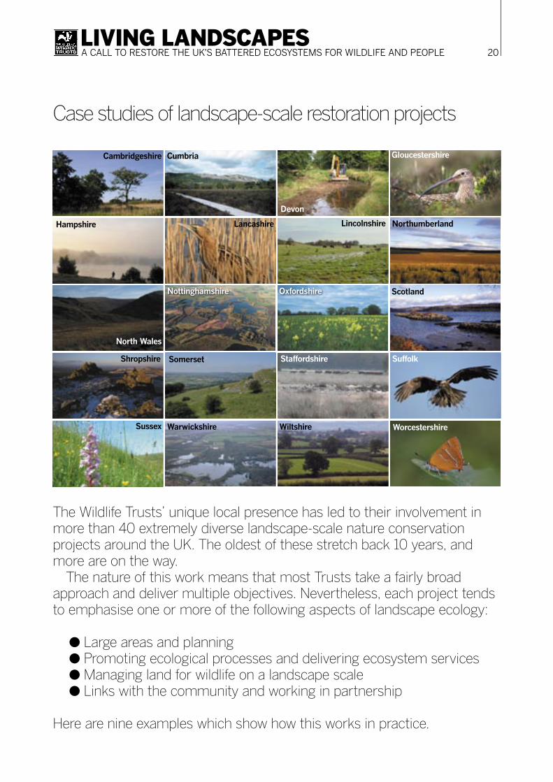
The Wildlife Trusts’ unique local presence has led to their involvement in more than 40 extremely diverse landscape-scale nature conservation projects around the UK. The oldest of these stretch back 10 years, and more are on the way.
The nature of this work means that most Trusts take a fairly broad approach and deliver multiple objectives. Nevertheless, each project tends to emphasise one or more of the following aspects of landscape ecology:
● Large areas and planning● Promoting ecological processes and delivering ecosystem services● Managing land for wildlife on a landscape scale ● Links with the community and working in partnership
Here are nine examples which show how this works in practice.
Case studies of landscape-scale restoration projects
North Wales
Cumbria
Devon
Gloucestershire
Hampshire Lancashire Lincolnshire Northumberland
Nottinghamshire
Cambridgeshire
Oxfordshire Scotland
Shropshire Somerset Staffordshire Suffolk
Sussex Warwickshire Wiltshire Worcestershire
21LIVING LANDSCAPESA CALL TO RESTORE THE UK’S BATTERED ECOSYSTEMS FOR WILDLIFE AND PEOPLE
IntroductionOver the last four years the South West Wildlife Trusts have been developing a science-based, structured framework for mapping the most vulnerable wildlife and habitats, called Rebuilding Biodiversity. Our objective has been to present a vision, backed up by a sound intellectual framework that shows what, where and how much wildlife habitat needs to be created in the South West region to guarantee the long-term survival of its biodiversity.
Focusing on UK Biodiversity Action Plan habitats, Rebuilding Biodiversity defines and selects a set of ecologically viable units of habitat, called Strategic Nature Areas (SNAs). Each SNA represents a potential landscape in which wildlife populations and rural communities can thrive in the long term, and through which habitat fragments can be interconnected to create a self-sustaining whole.
Rebuilding Biodiversity combines an evolving methodology and – critically – its application by local conservation experts across the region. The selection and
prioritisation of SNAs takes account of ecological viability and practical feasibility.
This is a powerful combination, and means that the choice of SNAs is relevant locally as well as regionally. In short, we argue that SNAs are the places where action to conserve, create and connect habitat should be focused.
Climate change and wildlifeWe have given much thought to the issue of climate change and its likely impact on wildlife, both during the development of the methodology and through its application. We believe that the SNAs identified will provide an essential tool to assist in the race to help habitats and landscapes adapt to the pressures of climate change.
Influencing regional policyThe best example of using the Rebuilding Biodiversity methodology to influence and lead policy development is its application by over 150 conservation experts across the
Rebuilding BiodiversityA science-based vision for wildlife in the South West of EnglandSimon Brenman Director of Regional Programmes, South West Wildlife Trusts
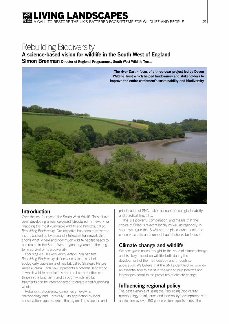
The river Dart – focus of a three-year project led by Devon Wildlife Trust which helped landowners and stakeholders to
improve the entire catchment’s sustainability and biodiversity

22LIVING LANDSCAPESA CALL TO RESTORE THE UK’S BATTERED ECOSYSTEMS FOR WILDLIFE AND PEOPLE
region to help produce the South West Nature Map above. The Nature Map is intended to inform conservation
strategies, regional spatial planning and the targeting of resources to maintain, restore, or recreate landscapes capable of supporting the full range of habitats and species treasured throughout the South West. The Map has been recognised by the South West Regional Assembly, Defra, Natural England and the South West Regional Development Agency.
Action on the groundThe South West Wildlife Trusts have begun unique, landscape-scale projects in each of the seven counties. The fundamental principle in each case is to create large areas of land that are in a conservation programme, but are not ‘off limits’ to people.
The first of these was a project to rebuild biodiversity over a large area of rural North Wiltshire. It is all about conserving, enlarging, and piecing together some of the best and most vulnerable wildlife-rich wildflower meadows, woodland, and hedgerows in the Braydon Forest area.
Further west, Somerset Wildlife Trust has a large area scheme well advanced in the Mendip Hills escarpment. As well as acquiring and restoring land themselves, they are providing advice to farmers and landowners from Wookey Hole right across to Cheddar Gorge. In Dorset, the Wildlife
Trust is concentrating on SNAs which can be enhanced by targeted landowner advice and local food promotion. Gloucestershire, Devon, Cornwall, and Avon have similar projects underway.
It is important to stress that farming, recreation, education and rural infrastructure (roads, houses, businesses) can all exist alongside and within the boundaries of the SNAs. The primary job is to secure the future for priority habitats and species that are threatened, but these projects are designed to take account of people as well as wildlife.
All the South West Wildlife Trusts rely on engaging the whole community in and around the project areas: the farmers and other landowners who can be helped to change their land management; the nature reserve managers who provide examples of what can be done; the traders and customers in communities who walk the fields and buy local meat from herds grazing carefully-managed, species-rich grassland.
Landscape-scale projects are our response to the unprecedented pressures of intensive agriculture, climate change, and the expansion of the built environment. Alongside this new vision, The Wildlife Trusts will continue all our current activities: managing local nature reserves, educating children, working with adult volunteers, promoting sustainable living, and standing up for wildlife through campaigning and lobbying.
The South West Nature Map, showing Strategic Nature Areas. Other regions in England are adopting similar methodology

23LIVING LANDSCAPESA CALL TO RESTORE THE UK’S BATTERED ECOSYSTEMS FOR WILDLIFE AND PEOPLE
The OnTrent VisionA river rich in wildlife habitats, landscape and historic features for the benefit of all, both now and in the future.
What is OnTrent? A long-term initiative to benefit local people, and the natural and cultural heritage in the parishes along the river Trent. It draws together a wide range of public, private and voluntary organisations, all of which have strong interests in the river’s future. The initiative seeks to reverse the continuing decline in biodiversity by securing a better balance between wildlife and agriculture, commercial activity and development. The prime focus is to create and manage wetlands where opportunities arise, and to conserve and enhance the landscape of the river and its environs.
The OnTrent aimsTo help improve the quality of life for local people and support the local economy by:
● Creating a rich diversity of linked wetland habitats along the Trent from Stoke to the Humber estuary;
● Encouraging sustainable practices in agriculture, forestry, mineral extraction and building development;
● Conserving and enhancing the river valley’s historic and cultural identity;
● Encouraging environmentally sustainable recreation and tourism;
● Working with organisations and land managers to promote the value of wetlands and, where appropriate, re-establish natural processes in the floodplain.
Background Over the last century the Midlands has suffered perhaps the worst decline in biodiversity of any English region. The river’s habitats, landscape features and archaeological resources, and the floodplain parishes that bound it, have suffered severe losses due to flood control, drainage, agricultural improvement, mineral extraction, built development and canalisation for navigationa. In both the
On TrentBenefiting wildlife, heritage and people in parishes along the Trent valleyRuth Needham OnTrent project officer, The Wildlife Trusts
The OnTrent project area covers 96,000 hectares

24LIVING LANDSCAPESA CALL TO RESTORE THE UK’S BATTERED ECOSYSTEMS FOR WILDLIFE AND PEOPLE
West and East Midlands, along the length of the Trent, these features are now fragmented. In some cases they are at risk from further degradation or destruction. Nevertheless, the Trent valley is strategically important for its wildlife, landscape, archaeology and recreational potential.
Project objectives To create a landscape fit for the 21st century, for both the river and its environs, from Stoke on Trent to the Humber estuary. The project respects and enhances local distinctiveness, and is creating a rich diversity of linked wetland habitats whilst providing opportunities to improve the quality of life for local people, support the local economy and conserve the river valley’s historic and cultural identity. This represents some of the key principles set out in the Government’s sustainable development strategy. A better quality of life will underwrite these objectives: putting people first, taking a long-term perspective and respecting the environment.
How partners are working Partners work together to capture resources, share information, influence policy, engage local communities and promote practical projects. They will encourage: ● Influencing of policies, funding mechanisms and planning
procedures to enable landowners and managers to assimilate wetlands into their enterprises;
● Increasing awareness and understanding of the significance of the valley landscape, the importance of the working countryside, the implications of development and the value of wetlands and sustainable floodplain management;
● Promote action and projects to conserve, enhance and create wetlands to benefit people, wildlife, landscape and historic interests.
The OnTrent partners The following are members of the Steering Group:● British Waterways● Country Land and Business Association● Derbyshire County Council● English Heritage● Environment Agency● Forestry Commission● Farming and Wildlife Advisory Group● Hanson
● Lafarge Aggregates● Leicestershire County Council● Lincolnshire County Council● National Farmers’ Union● Natural England● North Lincolnshire Council● Nottinghamshire County Council● Royal Society for the Protection of Birds● Severn Trent Water● Sport England ● Staffordshire County Council● The Wildlife Trusts
The Steering Group represents a wider range of organisations with interests in the OnTrent initiative. The OnTrent Forum is a much larger group that meets periodically to review progress and direction of the initiative.
Some examples of OnTrent projectsTrent Valley WayThis is a long-distance route along the Trent Valley. Although not always next to the river, the Trent Valley Way winds its way down the Trent through a changing landscape from its source to the sea. It connects a huge range of sites of interest from nature reserves, historic buildings, former wharfage areas and locks through the many villages and towns that the Trent flows past.
OnTrent is helping the Local Authorities to coordinate their access work along the Trent in a sympathetic manner and to improve public awareness and enjoyment of the river’s rich heritage.
Trent Vale‘Connecting the river to its people’. A range of partners are working together to plan a range of community and environment based projects linked to the Trent landscape between Newark and Gainsborough. Funded by the Heritage Lottery Fund, the work, if successful, will deliver a wide range of projects that enhance and restore some of the former Trent-based heritage for the benefit of everyone who lives in, works in or visits the area.
The Trent River Park projectThis promotes the role of the river as a regeneration corridor within and on the fringes of Nottingham. The objective is to create a model park for the 21st Century which exploits the power of water as a focus for sustainable regeneration of both the built and natural environment. The Park includes flagship schemes at both the Nottingham

25LIVING LANDSCAPESA CALL TO RESTORE THE UK’S BATTERED ECOSYSTEMS FOR WILDLIFE AND PEOPLE
Waterside, which is being transformed into a major new waterfront urban quarter for the city, and at Victoria Embankment, which is being regenerated into an exemplar, sustainable urban park as well as a range of other sustainable access and water based projects along the river corridor.
The OnTrent partnership is coordinated by a project manager based at Derbyshire Wildlife Trust. For more information please visit www.ontrent.org.uk or email [email protected]
26LIVING LANDSCAPESA CALL TO RESTORE THE UK’S BATTERED ECOSYSTEMS FOR WILDLIFE AND PEOPLE
IntroductionThe landscape of the Warwickshire, Coventry and Solihull sub-region has been dynamic since the last ice age 10,000 years ago. Habitat change is a natural process, running hand-in-hand with evolution; it has created the species diversity we recognise today. However, over the last 50 years the pace of environmental change has accelerated, primarily due to human intervention and the need for development.
Since the Second World War there has been an enormous reduction in the area and quality of wildlife habitats in the sub-region, stemming from changes in agricultural policy, planting of non-native forests to aid wood and paper production, and increasing urbanisation to meet the needs of a rapidly-expanding population.
Remaining habitats are now fragmented, resulting in isolated populations and limited gene pools which constrain the future viability of much of our native wildlife, particularly in the light of further predicted climate change. In Warwickshire, where much of the landscape is intensively
used for urban development or agricultural production, large areas of existing habitat are few and relatively small in the national context, making the landscape-scale method of conservation even more important for protecting and enhancing biodiversity.
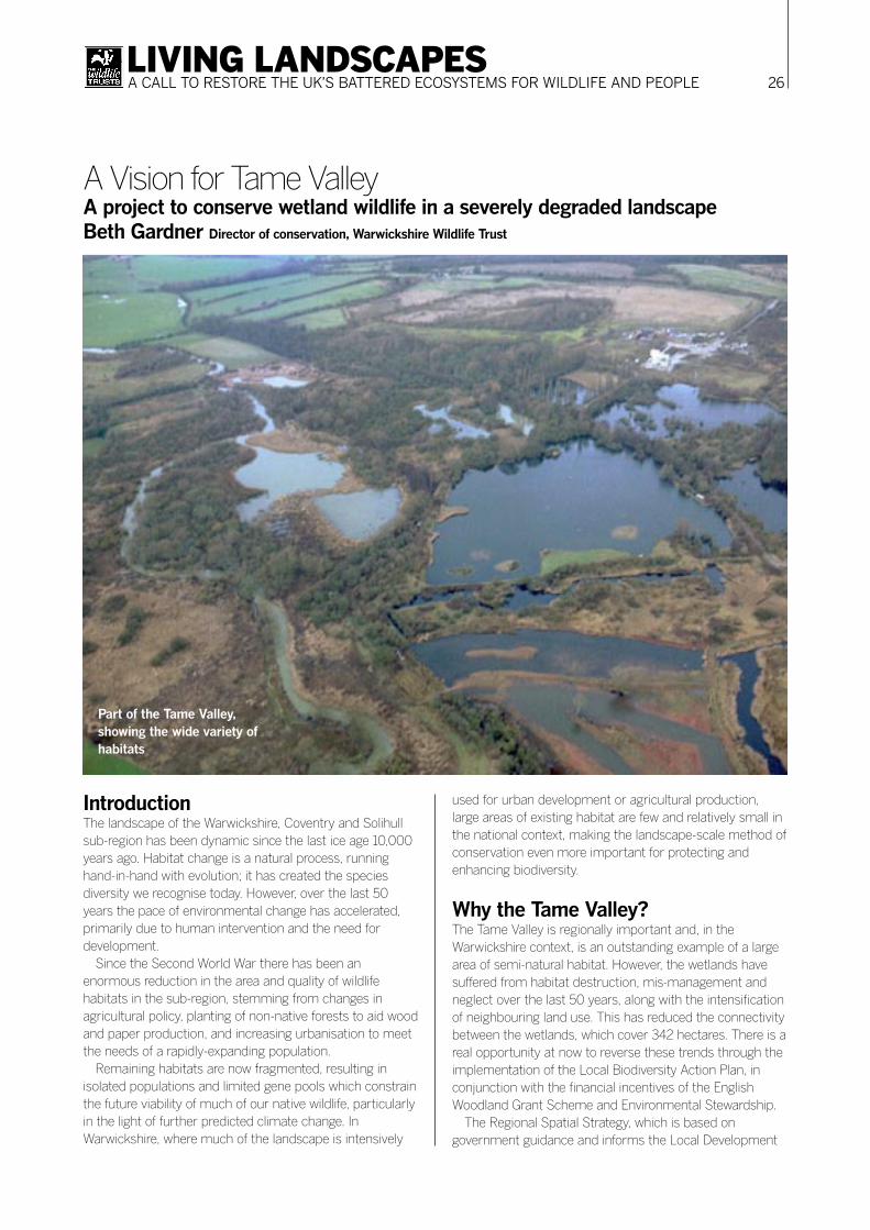
Why the Tame Valley?The Tame Valley is regionally important and, in the Warwickshire context, is an outstanding example of a large area of semi-natural habitat. However, the wetlands have suffered from habitat destruction, mis-management and neglect over the last 50 years, along with the intensification of neighbouring land use. This has reduced the connectivity between the wetlands, which cover 342 hectares. There is a real opportunity at now to reverse these trends through the implementation of the Local Biodiversity Action Plan, in conjunction with the financial incentives of the English Woodland Grant Scheme and Environmental Stewardship.
The Regional Spatial Strategy, which is based on government guidance and informs the Local Development
A Vision for Tame ValleyA project to conserve wetland wildlife in a severely degraded landscapeBeth Gardner Director of conservation, Warwickshire Wildlife Trust
Part of the Tame Valley, showing the wide variety of habitats

27LIVING LANDSCAPESA CALL TO RESTORE THE UK’S BATTERED ECOSYSTEMS FOR WILDLIFE AND PEOPLE
Frameworks within the sub-region, has highlighted the Tame Valley as a Biodiversity Enhancement Area (BEA). The strategy highlights that BEAs offer some of the best prospects for retaining environments with a rich and resilient biodiversity resource. The strategy suggests that these areas of ecological integrity should be reinforced by:
a) Supporting existing biodiversity and landscape enhancement projects;
b) Buffering habitat units from adverse impacts;c) Restoring and recreating locally characteristic habitats;d) Expanding and linking isolated habitat units;e) Promoting social and economic benefits by investing in
linked facilities for sustainable access, enjoyment and education, and in businesses that contribute to and capitalise on a high quality natural environment.
The Tame Valley itself contains a variety of designated sites, including:
● Whitacre Heath Site of Special Scientific Interest, owned and managed by the Warwickshire Wildlife Trust;
● Kingsbury Water Park, owned by Warwickshire County Council, and Ladywalk Nature Reserve (two reserves with enormous wildlife value)
● Lea Marston Water Treatment Centre, owned by the Environment Agency
● A variety of Sites of Importance for Nature Conservation (SINCs)
● Birmingham and Fazeley Canal● Links with the River Anker and the River Blythe
HBA and how it can helpHBA (Habitat Biodiversity Audit) maps the habitat types of all land in Warwickshire, Coventry and Solihull. Different habitats are recorded in different colours, making it easy to see patterns. The more colours on the map, the more important the wildlife habitat.
For example North Warwickshire has a lot of important wildlife habitat, ranging from wetland and open water areas of the Tame Valley in the west to the large areas of ancient and semi-natural woodland the area is famous for.
The HBA is owned and managed by a partnership in Warwickshire, which includes all the local authorities, the County Council, the Environment Agency, Natural England and the Warwickshire Wildlife Trust. The aim is to ensure no data are more than five years old.
This detailed picture of the county’s remaining wildlife resource shows that just 12 per cent of the area has
habitats that are attractive to wildlife. The Tame Valley is one of the best remaining examples. It is essential that these special habitats are protected, and that we create new habitats to link those that remain. To overcome the current threats we must create landscapes that allow wildlife to thrive and adapt to changing conditions.
This will only be achieved if we have large areas of connected habitat. In Warwickshire, this will always be limited by the scale of urban development, the major transport links and the high quality agricultural land needed for food production. But rather than bemoan these constraints, we should work positively with them to benefit our local environment.
Thanks to the support of a number of partners, we have been successful in obtaining funding for a project officer to kickstart this landscape approach to nature conservation in the Tame Valley. Initially, the focus is on Warwickshire. However, the wildlife corridor of the Tame Valley stretches north into Staffordshire and south to its confluence in Birmingham and the Black Country, and Warwickshire Wildlife Trust is working closely with the Green Arc Partnership to look at ways of extending the project and raising further funds to enhance the area.
Project aimTo enhance the biodiversity value of the Tame Valley by working with a range of partners and landowners to adopt a large-area approach to conservation.
Project Objectives1. To develop a strategy that has the support of the relevant
statutory and public sector bodies, landowners and the local community.
2. To enhance the management of existing wetland habitats, and enlarge Local Biodiversity Action Plan (LBAP) priority habitats, in particular reedbed, marsh, wet woodland and rivers.
3. To protect and enhance populations of priority wetland LBAP species such as water vole, otter, white-clawed crayfish, great crested newt and bittern.
4. To promote sympathetic land management on areas within the Tame Valley, in line with LBAP targets and actions, providing advice, guidance and signposting to landowners on areas such as SUDS (Sustainable Urban Drainage Schemes), the Biodiversity Benchmark, and agri-environment schemes.
5. To promote public access across the project area, and develop additional facilities to enable the public to actively engage with the LBAP process.

28LIVING LANDSCAPESA CALL TO RESTORE THE UK’S BATTERED ECOSYSTEMS FOR WILDLIFE AND PEOPLE
6. To monitor effectiveness of the project by surveying key species, and habitat change.
Warwickshire Wildlife Trust sourced funding to employ a project offi cer to manage and deliver the project. Half the funding came from WREN, and the Trust matched this. We wanted to demonstrate our commitment to working with partners within the Tame Valley and felt that, to kick start the project, it was important to put our money where our mouth was. Funding, support and expertise is now being sought from other partners.
Map showing the main areas in the West Midlands for landscape-scale habitat restoration. This is a
simplifi ed version of the HBA map described in the text.Source: Regional Planning
Guidance for the West Midlands (RPG11) GOWM/DCLG June
2004 TSO (London)

29LIVING LANDSCAPESA CALL TO RESTORE THE UK’S BATTERED ECOSYSTEMS FOR WILDLIFE AND PEOPLE
Setting the sceneThere is no doubt that the past practice of conserving small areas of land has done little to counter the rapid decline of biodiversity in the UK. Add to this cuts to agri-environment schemes and the predicted long term implications of climate change, and the future for our already wildlife-impoverished countryside does not look promising.
There are now many commentators who believe that the only way to turn the corner is to connect protected land through habitat restoration or creation schemes, or in some cases creating landscape-scale areas managed through natural processes such as using traditional animal breeds for grazing. It is an approach that has already been successfully demonstrated in the Netherlands and, to some extent, in Scotland and Dartmoor in the UK.
Although radical compared to traditional conservation land management practices, this new concept of rebuilding biodiversity on a landscape scale is arguably a rational and logical philosophy that may go some way to halt current environmental decline. This holistic concept is gathering
widespread support from both Government and non-Government agencies alike.
The time for change has come and a rethinking of mainstream conservation philosophy is now firmly on the agenda.
Rethinking biodiversity in WalesHere in Wales, we are all acutely aware of the need for a new conservation perspective. Wales was a country once rich in biodiversity, but the post-war agricultural revolution and Government pressures to intensify production by ‘improving’ the land has resulted in a fragmented landscape that supports an impoverished wildlife.
The new Environment Strategy for Wales produced by the Welsh Assembly Government (WAG) in 2005 highlights many of these issues and proposes the implementation of an integrated, flexible approach to the management of the land and sea to ensure that they can support our environment, economic and social needs while retaining their essential character and biodiversity – all by 2025. In
The Pumlumon ProjectA whole landscape in Montgomeryshire – people, place and natureEstelle Bailey Chief executive officer, Montgomeryshire Wildlife Trust
Pumlumon: an ancient landscape in need of joined-up land management

30LIVING LANDSCAPESA CALL TO RESTORE THE UK’S BATTERED ECOSYSTEMS FOR WILDLIFE AND PEOPLE
2007, WAG will implement its new Rural Development Plan and Rural Development Regulations, which will provide the delivery mechanisms necessary to achieve this.
In support of these objectives, the Countryside Council for Wales (CCW) is working towards its vision of a Wales more distinctive in landscape character, which includes greater biodiversity. CCW is currently developing a landscape strategy, which will support consideration of landscape issues in the planning process, and an Upland Management Framework for statutory sites to ensure that they are managed in a favourable condition.
The successful implementation of these strategies will require that modified environmental policy at UK and Welsh national level is supported by partnership working between Government and non-Government bodies, land managers and local communities.
Is there room for everything?Agriculture continues to make up 80 per cent of land use in Wales, forestry and woodland 12 per cent and urban and miscellaneous land use 8 per cent. Agriculture is therefore a critical driver linking economics, local communities and our natural heritage.
But is there room for everything, and is it possible to find a balance to serve all of these elements sufficiently well? We believe the message is simple – the necessary change can only happen if all sectors can find a way to work together.
Gwlad, edition 7, 2003 speaks for us:
Agriculture has a key role in sustaining the rural economy
ROGER Jones, chairman of the Welsh Development Agency, said that the unique role and quality of the rural economy depended upon sustaining and protecting the contribution of agriculture. “The future lies in developing added value and improved marketing.” He said support for rural development and community regeneration was a long-term process. “We are closely engaged in providing services aimed at ensuring long-term prosperity for agricultural areas – such as advising farm businesses on such issues as diversification, food processing and other value added opportunities. “The challenge must be to devise and bring to market a variety of imaginative enterprises linking the family farm with tourism, culture and heritage as well as food and drink products.” International marketing of the excellent food and drink produced in Wales was another top priority.
The Government, agriculture and biodiversityEncouragingly, in 2005, 263,000ha of land was managed under Tir Gofal (TG) agri-environment scheme agreements. TG management prescriptions aim to develop a more wildlife-friendly landscape and enhance biodiversity. However, imminent reductions in payments, coupled with a ten year agreement commitment, will make the scheme a less attractive long-term option to some landholders.
By 2007 it is proposed that there will be as many as three agri-environment schemes operating in Wales at different levels. Nevertheless, the most influential factor deciding the future of our landscape is not agri-environment schemes, but changes to the overall Common Agricultural Policy and reform of agricultural subsidies such as Single Farm Payments.
But can agri-environment schemes deliver increased biodiversity on their own? The answer is certainly no. More action is needed and, despite the significant effort made by a wide range of national and local Government bodies, including the Forestry Commission and Environment Agency, we need a new way forward.
A new way forwardNational and local Government must forge innovative relationships with non-Government organisations and communities to implement change that brings together a sustainable future for people, place and nature to co-exist.
The landscape-scale conservation philosophy is part of the solution and The Wildlife Trusts Wales are taking a lead role in this, not just here in Wales, but throughout the UK.
Selecting the project areaIn 2004, Wildlife Trusts Wales, Countryside Council for Wales, Forestry Commission, Environment Agency, John Muir Trust and others met to discuss a shared vision for a natural heritage project in mid Wales: the Cambrian Mountains region being the obvious choice.
The Pumlumon area was identified as the favoured location, and a notional project boundary was agreed. The project area covers approximately 30,000 hectares of upland landscape that supports at least ten local communities, 250 farm holdings, plus tourist services and facilities.
The Pumlumon landscapeThe landscapes surrounding Pumlumon are breathtaking, not only for their raw natural beauty, but for their wide

31LIVING LANDSCAPESA CALL TO RESTORE THE UK’S BATTERED ECOSYSTEMS FOR WILDLIFE AND PEOPLE
horizons and sense of space. The area is often referred to as the last isolated wilderness in Wales.
Pumlumon is the most central point of the Cambrian Mountains – the spine of Wales, which stretches north to Snowdonia and south to the Brecons. It is also the highest point at 752m, and is the largest watershed in Wales being the source of eight rivers: the Severn, Wye, Rheidol, Ystwyth, Elan, Teifi, Tywi, and Irfon. Approximately 5,000 hectares are designated as a Site of Special Scientific Importance (SSSI), and much of the area falls within the Cambrian Mountains Environmentally Sensitive Area (ESA).
Agriculture continues to be the mainstay of the area, but other visually dramatic evidence reveals a history of land use from the pre-historic period to the present.
Scattered archaeological features and prehistoric remains, mine workings, the Sarn Helen Roman road, medieval settlements, Drovers routes, the Strata Florida Abbey, parliamentary enclosures and abandoned farmsteads all speak to us through this remote and ruthless landscape.
The area is esteemed for its associations with the 14th
century Welsh bard and lyricist Dafydd ap Gwilym and Owain Glyndwr, who defeated the English at a battle on Pumlumon; and more recently artistic associations and the setting for Thomas Jones’s Hafod.
Cattle once roamed freely over the horizons of Pumlumon, but have since been lost to intensive sheep production. Pumlumon is now regarded as traditional Welsh sheep-walk. Post war changes in land use have seen the creation of extensive forestry plantations and the Nant-y-Moch hydroelectric scheme.
As with most of the uplands across Wales, intensive land use has resulted in a significant loss of biodiversity, with many of the habitats being either lost or degraded to poor condition. Overgrazing of sheep has induced soil compaction, which has resulted in increased flooding of the lowland areas.
Local communities rely on the area for their livelihood but as with many other rural communities across Wales an air of depression and desertion is apparent, despite the limited success of recent attempts to encourage farm diversification and increased tourism to the area.
Lapwing, a bird characteristic of farmed uplands
32LIVING LANDSCAPESA CALL TO RESTORE THE UK’S BATTERED ECOSYSTEMS FOR WILDLIFE AND PEOPLE
Pumlumon Natural Heritage ProjectWildlife Trusts Wales have been the lead partner of the project design, and in agreement with the other partners have developed a vision statement and project objectives.
Our shared vision is simple and our objectives are clear:
The Pumlumon Project will provide a sustainable landscape that supports a renewed wealth of biodiversity, a place where people can thrive and make a living from the land, and a place where people can go to experience a unique culture and natural heritage.
Underpinning project objectives1. Build capacity within rural communities to ensure the
future of sustainable hill farming including the conservation of local natural and cultural heritage.
2. Provide appropriate mechanisms to enhance, expand and reconnect natural upland habitat features, and the wildlife they support.
3. Actively promote the financial and cultural links between farming, wildlife conservation, local communities and commercial enterprise and the combined opportunities they provide.
4. Advance the education of the public and local communities, emphasising the important relationships between sustainable upland hill farming, agriculture and wildlife conservation.
5. Provide advice, means and support for local people to implement innovative and sustainable projects.
6. Widely promote the natural beauty and cultural heritage of the area and encourage innovative tourism, recreation and farm diversification opportunities
7. Lobby both partner organisations and external bodies to ensure that landscape-level conservation is viewed positively.
Who will design the project? The Wildlife Trusts Wales will continue to work in association with the current project partners and in consultation with Welsh Assembly Government, local landholders, communities businesses and other experts such as PONT (Wales Grazing Animals Project).
Who will deliver the project?This is a grass roots project that will be delivered by local landholders, communities and businesses under the guidance of an enabling strategic framework. A number of Project Officers will be employed to help with this process.
How will the project be delivered? A strategic and financial framework will be created based on the project objectives detailed above.
Project Officers will produce tailored action plans in consultation with those wishing to join the project. These action plans will include the coordination of a number of individual parties to address larger issues that include the creation of wildlife corridors, value-added marketing schemes, or the provision of targeted reskilling.
How will the project work over such a big area?The strategic framework falls into three main elements.
1. Conservation of natural heritageA management plan will be constructed for the entire landscape within the project area, based on scientific data. This plan will then be broken down into jigsaw pieces based on individual landholdings. Each participating landholding will have a tailored farm plan comprising three parts. One part will be an individual landscape action plan – their part of the jigsaw. Management of the detailed prescriptions will deliver the desired conservation objectives.
2. Sustainable communities Sustainable communities are essential for the survival of cultural heritage and the replenishment and conservation of natural heritage – biodiversity. This project aims to engage local communities in their environment through involvement in sustainable projects and initiatives.
3. Commercial enterpriseCommercial enterprise is dealt with in each individual farm plan and as a separate service to local businesses and enterprise schemes.
Appropriately trained Project Officers will manage each element.
Why choose this model?We have used the UNESCO model that is based on managing areas by zones. Three zones have been identified within the project area – Core, Buffer and Transition. These interrelate closely with anthropological activity, or inactivity.
This is the ideal model for delivery of the strategic framework. The core area is a relatively intact block of good quality viable habitat to which ecological networks can be connected to link other significant areas.

33LIVING LANDSCAPESA CALL TO RESTORE THE UK’S BATTERED ECOSYSTEMS FOR WILDLIFE AND PEOPLE
Project area boundary
Core
BufferTransition
Conservation of Natural Heritage: The UNESCO Model
The buffer and transition zones have been identified as areas that have the potential to be connected to the core area by creating or restoring ecological networks across the entire landscape. This methodology used in conjunction with a Landscape Character Assessment of the project area will allow us to build a picture of a future landscape. CCW’s Upland Management Framework will also be used in this process to help guide future management objectives.
How did we choose the core zone?This was an easy process. We identified the Pumlumon Site of Special Scientific Interest as our core area, totalling some 5,000 hectares in size.
The principal land cover that unifies the core zone is largely dominated by a complex mosaic of locally, nationally and internationally important habitats and species, such as dry and wet dwarf-shrub heath, ombrogenous blanket bog, unimproved acid grassland and a number of oligotrophic lakes. Pumlumon is also an important area for bird fauna (breeding, wintering and feeding birds) particularly hen harrier, merlin, short-eared owl and red and black grouse.
Delivering the project objectives
1. Build capacity within rural farming communities to ensure the future of sustainable hill farming including the conservation of local natural and cultural heritage.
Delivery mechanisms:● Introduce a local agri-environment scheme that will pay
for agreed capital and revenue works additional to current agricultural support systems, with entry options agreed within the project framework.
● Produce a tailored Farm Plan comprising three equally weighted elements:
1. Farm Landscape PlanThis will be derived from the whole area landscape study. It will create a biodiverse and ecologically connected landscape, delivering Local and National Biodiversity Action Plan targets. It will also maintain biological provenance, deliver Ecosystem Services, and maintain or restore traditional farm and archaeological features.
2. Farm Resource PlanThis will evaluate the capacity of the farm. It will enable the farmer to participate in a landscape grazing animals project; switch to farming traditional breeds of cattle, sheep and ponies; farm for wildlife (making wildlife a crop); and produce energy crops or other sources of renewable energy.
3. Business Development PlanThis will allow the farmer to receive advice on Rural Enterprise initiatives and Farm Diversification options; support and use local product ‘branding’ where appropriate; take advantage of training and re-skilling opportunities; and create new countryside access opportunities.
2. Provide appropriate mechanisms to enhance, expand and reconnect natural upland habitat features, and the wildlife they support.
Delivery mechanisms:● Rebuild biodiversity on a landscape-scale through the
production of an overarching Whole Area Landscape Strategy.
● Production of a Farm Landscape Plan by selecting relevant modules from the Whole Area Landscape Strategy. Unique to each landholding, this FLP will be produced by the conservation advisory officers in consultation with the landholder. The plan will be
34LIVING LANDSCAPESA CALL TO RESTORE THE UK’S BATTERED ECOSYSTEMS FOR WILDLIFE AND PEOPLE
implemented by the landholders supported by the project estate team (where necessary).
Whole Area Landscape Strategy Action Plan objectives:● Ensure that existing habitats and species of importance,
and other key features including archaeological features across the project zones are managed at favourable condition.
● Increase the ecological carrying capacity and quality across the project zones by connecting and extending fragmented habitats through restoration or habitat creation projects.
● Restore natural ecological processes by introducing traditional grazing animals and other lost native species through a community grazing animals project.
● Use practical assistance where necessary to help restore natural ecological processes.
● Re-introduce selected lost species once native to Britain or Europe for conservation and revenue purposes.
Survey and Monitoring● Support a programme of survey and monitoring of
habitats and species and natural ecosystem resources to be undertaken by a professional team of ecologists and conservation officers on individual landholdings
● Pay full regard to climate change and the possible repercussions it may have to current ecosystems.
● Monitor habitat management impacts on natural capital including hydrology, soils and carbon sequestration.
3. Actively promote the financial and cultural links between farming, wildlife conservation, local communities and commercial enterprise and the combined opportunities they provide.
Delivery mechanisms● Production of a broad-brush development Strategy for
the project area.● Creation of additional employment and training
opportunities, particularly for young people, in conservation management, tourism, and visitor management.
● Referral to existing business support services and training initiatives.
● Small Grant Scheme to support new business ventures.
New business development● The development strategy will help to integrate local
regeneration initiatives that impact on the project area● The plan will be administered by the project (or
contracted service) and will offer general business advice and training, support and advice about potential business ventures. The service will be responsible for administering a small business grant aid scheme.
● Priority initiatives: Farm diversification initiatives not included in a Farm Business Plan, but targeted at local communities and commercial enterprise. Initiatives include eco tourism and recreation, environmental and cultural heritage education, the local services and community partnership projects.
4. Advance the education of the public and local communities, emphasising the important relationships between sustainable upland farming and wildlife conservation.
Delivery mechanisms● Provide informal opportunities and facilities to engage
people in learning about farming, local culture and wildlife conservation.
● Form partnership agreements with formal training providers and other organisations.
● Develop an extended volunteer programme covering conservation, visitor management, events, and activities.
Implementation● Employment of an education, training and volunteer
organiser as part of the project● Employ Warden’s to lead guided walks.● Open a new visitor centre with interactive facilities, a
visitor attraction, and accommodation● Install appropriate on site interpretive material● Organise open days, school trips, and other events● Run training courses, workshops, and short breaks.● Use other local community resources to promote the
project and educational initiatives● Produce a suite of educational and promotional leaflets
and materials including multi media● Develop a website for the project
5. Provide advice, means and support for local people to design and implement innovative, sustainable projects.
Delivery mechanisms● Promote partnership working between farmers, local
groups, Government and non-Government agencies.● Offer an ‘enabling’ advisory service to local people about
setting up groups and viable community projects, and seeking funding.
● Provide start up grants for qualifying projects.

35LIVING LANDSCAPESA CALL TO RESTORE THE UK’S BATTERED ECOSYSTEMS FOR WILDLIFE AND PEOPLE
● Help local groups acquire the new skills necessary to implement and manage change.
Community Projects● Employ a Community Projects Officer to actively work
with and advise local community groups about setting up and running sustainable projects, including local community strategies projects and community businesses initiatives.
● Offer ongoing support and a contacts network service for new and existing projects.
● Distribute up to date literature and information to groups on behalf of other groups, local Government, Government agencies and other organisations.
● Give advice on promoting local projects and recruiting volunteer support.
● Support opportunities that are inclusive and remove access barriers to the countryside.
● Run training events, tailored to the needs of the local community.
6. Widely promote the natural beauty and cultural heritage of the area and encourage susceptible innovative tourism, recreation and farm diversification opportunities
Delivery mechanisms● Developing new promotional initiatives and opportunities,
in co-operation with existing marketing organisations such as Visit Mid Wales and the Mid Wales Tourism Partnership.
● Provide new PR opportunities, editorial comment and other literature describing the project and its impact, to encourage visitors and active participation.
● Encourage the development of consortia and other partnerships linking accommodation, activities, visitor attractions, and events.
Tourism and recreation● Use the development strategy and output from Farm
Development Plans to identify associated business opportunities, to include:
● Walking, hiking and trekking● Water sports ● Pony trekking● Fishing and Shooting● Wildlife tours and photography● Visitor centre and education● Activity breaks – extreme and gentle
● Arts and tranquillity experiences● Practical conservation work● Health and well being● Ecotourism● New kinds of tourism accommodation
Farm diversification● Branded quality assured meat and produce.● Farm related activities.● Encourage eco friendly products and services.● Produce good quality publicity literature.
7. Lobby both partner organisations and external bodies to ensure that landscape level conservation is viewed favourably.
Delivery mechanisms● Influence local and national rural development policies in
favour of landscape initiatives.● Lobby for strengthened national and local rural
development policy that makes certain the protection of key project features.
Key opportunities● Lobby for strengthened national and local rural
development policy that support key project features. Ongoing CAP reform will provide key opportunities to influence the development of the Common Agricultural Policy from the present Rural Development Policy review to the further and probably more radical review set for 2013.
● The implementation of other directives likely to have a key role in shaping the future of rural Wales offers additional opportunities including the implementation of the Water Framework Directive.
● Additional policy frameworks also present the opportunity for dialogue. CCW’s Upland Strategy and the WAG Environment strategy both offer opportunities to modify policy implementation.
Edited by Clive Faulkner, Stephen Hughes and Robyn Benbow of Montgomeryshire Wildlife Trust. On behalf of Wildlife Trusts Wales.

36LIVING LANDSCAPESA CALL TO RESTORE THE UK’S BATTERED ECOSYSTEMS FOR WILDLIFE AND PEOPLE
VisionThe Idle Valley Project (IVP) offers an exceptional opportunity to show how enhancement of biodiversity can help boost local economies. Nottinghamshire Wildlife Trust (NWT) is working to re-establish linked wetland habitats in river flood plains, and a key contribution is sustainable farmland management in the surrounding areas. The IVP is a fantastic opportunity for the Trust to achieve these objectives, and contribute to social and economic regeneration for the surrounding communities.
HistoryHistorically, the rivers flowing through Nottinghamshire downstream to the Humber estuary wound slowly through broad landscapes of marshes, reeds and pastures, all teeming with wildlife. Then, over many centuries, people progressively drained the valleys for agriculture and other development, greatly diminishing the quantity and diversity of its wildlife.
The Idle Valley’s enormous washlands were gradually destroyed first by the Romans, then by the Dutch engineer Vermuyden in the 17th century, as he introduced industrial drainage, and finally by a major flood defence scheme in the 1970s and 80s.
Project area and partnersThe IVP concerns 450 hectares of gravel pits and farmland along the River Idle north of Retford – home to the greatest concentration of wildlife in north Nottinghamshire. Large parts of the area are designated as the Sutton and Lound Gravel Pits Site of Special Scientific Interest (SSSI), principally for their spectacular assemblages of wetland birds. The potential for habitat restoration on surrounding land, and along the River Idle, is great.
The project is promoted by a committed partnership led by Nottinghamshire Wildlife Trust and Tarmac Central Ltd, North Nottinghamshire College, Bassetlaw District Council and Nottinghamshire County Council.
The Idle Valley ProjectA plan for sustainable wildlife, flood reduction and a better local economyCharles Langtree Head of estate management and development, Nottinghamshire Wildlife Trust
The Idle Valley has an exceptional variety of habitats which the Nottinghamshire Wildlife Trust is committed to securing in perpetuity
37LIVING LANDSCAPESA CALL TO RESTORE THE UK’S BATTERED ECOSYSTEMS FOR WILDLIFE AND PEOPLE
The Idle Valley todayThe valley was once known for its extensive seasonally wet grassland, with vast overwintering and breeding flocks of wildfowl and waders, and rich plant communities. Until only a few decades ago, the river meandered through traditionally-managed wetland pastures of which only very few fragments still remain. Extensive channelisation and construction of flood-banks in the last few decades have resulted in a highly-managed river that can no longer follow its natural course and has virtually no remaining functioning floodplain.
Whilst the need to protect settlements from flooding remains a priority, the imperative to protect farmland is declining. Crop values are falling, and there is a recognition of the wider benefits of naturally-functioning floodplains – including enhanced protection for settlements downstream, the maintenance of a diverse and rich landscape, and the restoration and re-creation of our lost wetland biodiversity.
The wildlife of the project areaThe 316 hectares of Sutton and Lound Gravel Pits SSSI is an old gravel pit complex with extensive areas of shallow and deep open water. A wide range of naturally-colonising habitats includes sparsely-vegetated gravel islands and shorelines, and marginal vegetation communities. The open water and margins support an exceptionally rich range of breeding, wintering and passage birds, some of national importance.
There are proposals to improve the wetlands for breeding birds which inhabit wet grassland, reedbeds and other waterside habitat. Species of national importance include black-necked grebe, garganey, pochard and wigeon. Other rare birds include redshank, snipe, curlew, little ringed plover, bittern, marsh harrier and bearded tit. Several of these species’ strongholds are currently on the coast and are expected to be indefensible after c.2025 due to global warming and the resulting rise in sea levels. Strategic planning for the future protection of suitable inland habitats for these rare species is therefore vital.
Less threatened birds include shoveler, shelduck, tufted duck, great crested grebe, water rail, sparrowhawk, tawny owl and many other woodland and scrub species. Long-eared owls overwinter in the reserve’s undisturbed hawthorn thickets, and may nest in the same habitat. Owls use wide areas of the gravel pits for feeding.
Mammal interest involves scarce and localised species including otter, water vole and harvest mouse, while stoat and badger maintain good on-site populations.
A good range of nationally important invertebrates, including water beetles, was recorded in a survey of the tiny Chainbridge Lane nature reserve, which was given to NWT by Tarmac in 1988. All parts of the SSSI are valuable invertebrate habitat.
Amphibian and reptile populations contain scarce and localised species that will benefit greatly from sympathetic management. These include grass snake, slow worm, great crested newt and smooth newt.
Under the Nottinghamshire Biodiversity Action Plan, the Habitat Action Plans which affect the SSSI include wet broad-leaved woodland, ancient and/or species-rich hedgerows, lowland wet grassland, reedbed, fens and marshes, mesotrophic lakes, rivers and streams and post-industrial land. The Species Action Plans for bats, water vole, otter and probably barn owl also apply.
Local volunteers from the Lound Bird Club won the BTO-Hanson Business Bird Challenge 2004 for a major wetland site by recording 188 species of bird – the most recorded at any site in the competition.
Funding the projectWith funding from East Midlands Development Agency, Sheffield Hallam University and ADAS quantified the environmental, economic and social gains that could arise from the project. They concluded that abundant opportunities exist to meet these gains within the primary objective of a nature conservation area.
A second study, paid for by the Mineral Industry Sustainable Technology fund and undertaken by ADAS and Smith Woolley, recommended economic and social activities that could maximise the project’s potential for benefit to people and wildlife.
It concluded that the project would generate enough profit to cover the cost of maintaining the SSSI in favourable condition in perpetuity through tourism and a visitor centre. However, the visitor centre would not necessarily be a top priority in the initial stages.
Bassetlaw is the 74th most deprived of 376 local authority areas in England. Due to its previous dependence on coal mining, it has since developed acute social problems. Retford, a market town of 21,000 people, includes six wards in the 10 per cent of those most deprived in England. The economic and social regeneration of Retford is an extremely high priority for the region.
The potential development of the area as a centre for learning has taken a real leap forward as a result of North Nottinghamshire College securing both funding and planning permission to construct a new education facility.

38LIVING LANDSCAPESA CALL TO RESTORE THE UK’S BATTERED ECOSYSTEMS FOR WILDLIFE AND PEOPLE
North Nottinghamshire CollegeAn exciting opportunity for synergy has emerged with the inclusion of North Nottinghamshire College (NNC) as a partner in the project. NNC currently runs a range of rural skills training courses, but due to the varied and extensive nature of this curriculum its activities are currently spread throughout the district in different locations based on a range of sub-contracts. Inclusion in the project would give NNC access to a single local base with extensive training opportunities on site and help the college greatly.
As a leader in rural education, NNC has a strong commitment to the ‘rurality’ of Nottinghamshire and to increasing its presence in the eastern half of the district. It has long been interested in establishing a permanent rural learning base that could become a centre of excellence. Current courses include amenity horticulture, rural economy, rural conservation, sustainable energy, equine studies and small animal care. The college plans to broaden the range of classes available to students with learning disabilities and special needs.
A base within the project would allow NNC to have one rural education department. Desired facilities include a ‘learning barn’, classrooms, plant and machinery storage, catering and possibly an equestrian centre. NNC is also very committed to environmentally sustainable building.
The unique educational opportunities for associated skills and labour learning resulting from NNC presence on the site include:
● Conservation management on the SSSI (rural conservation courses)
● Stock keeping/lambing (animal handling courses)● Business development through rural social enterprises● Work placements in micro-businesses on-site● Native tree nursery and wildflower production ● Catering students involved with the café/restaurant● Tourism/leisure students involved with visitor centre
This opportunity if realised through the project could offer unprecedented educational benefits to a large number of participants.
The project could also offer significant training opportunities through the Intermediate Labour Market and Environmental Task Force. Real and sustainable jobs would result from micro-business and social enterprise development around the area of high environmental quality.
This project has great potential to deliver Bassetlaw’s objectives relating to education, skills and training issues. To maximise the local benefits of education and training
provision, there must be local employment. The project will equip people with transferable skills to employ at nearby developments, such as Finningley Airport.
Improved access and interpretationIt is hoped that the progressive approach to protecting and enhancing the valley’s wildlife value adopted by the project partners will also deliver significantly enhanced opportunities for public access and improved interpretation facilities for visitors.
Health benefitsSurveys in Bassetlaw show that the health of residents is poor and long-term illness is documented as well above average. As a resource for health and fitness, the project could help this situation significantly by combining exercise and contact with nature. Local residents, most of whom do not currently visit the countryside or experience much contact with it, will benefit especially. The wider land area lends itself to green gyms, nature therapy, walking for health programmes and GP referral schemes. Links with schools for health and fitness as well as for nature conservation will be relevant to the two new schools planned for the area.
GP referral schemesThe project is linking with the following local schemes:● ‘Go For Fit’ exercise referral scheme run by Bassetlaw
Leisure Services and Bassetlaw Primary Care Trust aims to improve patients’ health by increasing their exercise. Doctors, practice nurses and health visitors presently refer patients to Retford Leisure Centre.
● ‘Cardiac Rehabilitation Phase IV’, administered by Bassetlaw Leisure Services and Bassetlaw and Doncaster NHS Trust encourages people who have had a heart attack or coronary incident to continue exercising after they have completed Phase III of their rehabilitation at Bassetlaw Hospital.
● ‘Walking the Way to Health’ is a partnership scheme including Bassetlaw Leisure Services, British Heart Foundation, Natural England, Bassetlaw PCT, and Bassetlaw and Doncaster NHS Trust. It aims to get sedentary people more active through walking. Referrals are made from GP Surgeries across Bassetlaw.
Crime reductionThe project could help crime reduction targets. Nature conservation and environmental improvement are high on the list of projects sought by Youth Offending Team officers.

39LIVING LANDSCAPESA CALL TO RESTORE THE UK’S BATTERED ECOSYSTEMS FOR WILDLIFE AND PEOPLE
The project may also include an initiative to change the behaviour of young people habitually involved in truancy, crime and drug addiction, by offering them the chance to learn basic conservation and other countryside activities.
Economic benefitsA social economy helps reduce social exclusion and promotes the regeneration of disadvantaged areas. As the socially-owned businesses proposed in this paper develop and grow they will help local people’s health and education at the same time as contributing to the local and regional economy. They would also exemplify the profitable alternative of sustainable practice to a rural community heavily involved in conventional practices. If the plan succeeds it could have far-reaching effects in an area that needs more employment and economic regeneration.
The rural enterprises under consideration are carefully selected to meet a number of aims:
● Contributing to the primary aim of conservation for the area, whilst securing maximum potential profitability
● Providing a wide range of opportunities for skills training● Incorpration of volunteers for health and fitness benefits● The ability to create a model which regional practitioners
can follow● The aesthetic enhancement of the wide area landscape
The social benefits of these options would help secure funds for the highest standard of conservation management of a nationally-important wildlife sanctuary.
The partnership has approved the following enterprises and categories for further consideration:
EDUCATIONAL CONSERVATION
Basket makingWillow crafts
Reed bedsSedges
RETAIL BUSINESS
Native tree nurseryWild flower seedsFloristry Willow charcoal (artistry)Lumpwood charcoal
Composting (communal)WormeryBeekeepingLivestock productsBiomass (producing plant material for power)
TOURISM
Shop Restaurant/quick cateringFacilities for local groups
Guided walksHoliday clubExhibitionsCar parking
Such a combination of enterprises would contribute greatly to the economic viability of the wide-area project.
To give businesses the best possible support and mentoring, the partnership will liaise with relevant organisations and funding bodies, thereby reducing the possibility of business failure.
TourismResearch shows that a ‘beacon’ nature reserve attracts visitors from far away. The trend away from overseas tourism, the increasing number of short breaks, and the uplift in special interest holidays underline this potential, as does the growing market for child-friendly experiences.
Promoting the area as a regional attraction will encourage visitors to stay overnight. Pubs, hotels, B&Bs, restaurants and shops will benefit. Combined with the highly successful Clumber Park and other Sherwood venues, as well as attractions in Lincolnshire and Yorkshire, the site could help to create a cluster of attractions for joint promotion and multi-site permit purchase.
Visitor centre The economic studies show that this can co-ordinate the whole project, greatly increasing the prominence, visibility and accessibility of the site. It will be an exemplar ecobuilding, heated either by wood chip produced on site, or by geothermal energy from the adjacent lake, and constructed after a widely-publicised architectural competition. Integrated with the North Notts College facility, it will deliver environmental education and foster a greater understanding of a natural heritage little known to local residents and the wider population.
SummaryThe Idle Valley Project is a unique opportunity to secure the conservation management of a major site in the East Midlands. It will meet educational, economic, social, tourism and health agendas, and show how sustainable development can integrate these activities.
The visitor centre, new jobs, co-operation from North Notts College, and links with Primary Health Care Trusts will involve local people throughout. Visitors from a large catchment area will further stimulate the local economy.
The conditions for this type of project may be present in most areas of the UK, providing similar opportunities to maximise social and economic benefit through environmental conservation. We hope it can be a model that others can follow.

40LIVING LANDSCAPESA CALL TO RESTORE THE UK’S BATTERED ECOSYSTEMS FOR WILDLIFE AND PEOPLE
The conceptRebuilding Dorset’s Biodiversity is a major new initiative for the Dorset Wildlife Trust and our partners. DWT believes that a wildlife-rich environment increases everyone’s quality of life and wants to pilot a new initiative to help stop the decline of the county’s wildlife. The two year initial phase is funded by the Esmée Fairbairn Foundation.
The concept is to restore large, ‘landscape’ areas of the county, linking fragmented habitats with land rich in wildlife, alongside flourishing and sustainable communities. There are a variety of ways in which this can be done, including working with many different groups of people, sometimes individual landowners and sometimes whole communities.
With a portfolio of nature reserves, and its work in the wider countryside, the Trust was well placed to begin several pilot schemes. Some we hope to put in place will be self-perpetuating and some may need further funding. We anticipate that this way of working will bring a new focus to our activities and lead our future plans. It is a considerable challenge for DWT but one that is vital to meet.
In 2002 the eight Wildlife Trusts in the South West of England decided to develop the concept of Rebuilding Biodiversity across the region (p21). We now have a common scientific methodology and, with partner organisations, priority areas identified for action.
The need for the projectDuring the last decade it has been recognised that, although much has been achieved in the UK during the last 50 years, wildlife is still declining. Given the economic pressures on land, coupled with the effects of climate change and the basic ecological needs of wild species, conservationists are now questioning whether our current approach can ever succeed in maintaining the UK’s full diversity of species and wild places. Significantly there have been declines in the populations of wider-countryside species. For example, research on the greater horseshoe bat has shown that it cannot be conserved just by providing protected roosting sites. Bats need a network of areas of high-quality surrounding countryside in which to feed.
Rebuilding Dorset’s BiodiversityRestoring Dorset’s fragmented habitats for wildlife and peopleImogen Davenport Head of conservation, Dorset Wildife Trust
View from Eggardon Hill in Dorset. Mosaic countryside like this allows wildlife to move and adapt to climate change

41LIVING LANDSCAPESA CALL TO RESTORE THE UK’S BATTERED ECOSYSTEMS FOR WILDLIFE AND PEOPLE
Today, most conservation sites are too small, too isolated and often too lacking in quality, not just for bats but for many different species.
It is acknowledged that biodiversity is a concern of global importance and a measure of the quality of the environment in which not only plants and animals live but on which people also depend. The concept of Rebuilding Biodiversity on a large scale was adopted early on in Holland and the United States. In turn this has inspired conservation organisations in the UK, several of which have produced strategies for action on this scale.
Project aims and objectivesThe overall aim of ‘Rebuilding Biodiversity in Dorset’ is to increase the biodiversity of the county as a whole and to raise awareness of the importance of doing this, not only for the benefit of wildlife but also for people. Within this we will:● Initiate a programme of landscape-scale conservation
within pilot areas in Dorset● Engage a wide partnership, including from outside the
conservation sector, and secure their support for, and participation in, landscape-scale conservation
● Maintain close links with others working in landscape-scale conservation
Biodiversity objectivesThe intention is to create, or re-create, priority biodiversity habitats in substantially larger areas than are there at present. The long-term target is for 60 per cent of the selected areas to become habitat of high value to wildlife (modelling has shown that, at this level of 60 per cent, there is much greater connectivity between habitats). The remaining 40 per cent of the land could be made up of settlements, more intensively farmed land and other development or, indeed, other associated habitat. Obviously within a two year pilot we can only carry out the groundwork and get things moving towards this target, not least because most habitats of high wildlife value take many years to establish.
From strategic mapping work (the South West Nature Map), six potential pilot areas were selected as a basis for further research. These areas were chosen:
(a) because of the presence of core, existing nature conservation sites, which can provide the basis for re-colonisation of the wider countryside;
(b) because there is the potential for the recreation of appropriate habitat(s) within the surrounding areas; and
(c) because DWT is well placed to lead work in that location.
Initial feasibility work identified three pilot areas where DWT will start to implement a new, holistic approach to nature conservation. These are:● The River Allen catchment in eastern Dorset (key BAP
habitats: chalk river, floodplain grazing marsh) ● The Cerne and Sydling valleys north of Dorchester (key
BAP habitats: lowland calcareous grassland, chalk rivers) ● The Kingcombe/Powerstock/Corscombe areas in the
west of the county (key BAP habitats: lowland meadows, lowland mixed deciduous woodland, fens, wood pasture and parkland)
Social and economic benefitsLocal communities are crucial to the success of the project and indeed will be the immediate beneficiaries of it. Wider involvement of the local community will give the project a greater chance of success. The participation of individual local landowners and the opportunities through community planning and volunteering will help raise awareness of the project. Rebuilding biodiversity can and should lead to increased benefits for local economies. Linking environmental assets with local tourism initiatives, for example local walks with wildlife-rich countryside, will increase the need for refreshment and accommodation (eg farm bed and breakfast, and public houses).
MethodsWhilst ‘traditional’ conservation methods are a valuable part of this project, it will include different and innovative approaches. To secure enough participation, new funding mechanisms may also be required.
● We will work with landowners to encourage them to manage their land sympathetically. DWT staff already advise farmers on funding available. For example, with Environmental Stewardship grants, we carry out wildlife surveys and help compile applications.
● Further investigation is needed into co-operative landowners’ schemes for land management, including local grazing schemes and local product marketing.
● DWT may also need to provide advice outside our expertise in areas where intensive farming or forestry is by far the most prevalent type of land management at present. Advice of specialists may be required in order to secure changes in management which provide equal or better economic returns.
● Biodiversity priority species will be used as focal points for recreating habitats and this approach will be used to encourage volunteer participation and corporate funders.

42LIVING LANDSCAPESA CALL TO RESTORE THE UK’S BATTERED ECOSYSTEMS FOR WILDLIFE AND PEOPLE
● Influencing the planning process to secure positive management of areas which link conservation sites will be another approach. As part of this process local communities will be engaged.
● DWT is aware that many people buying substantial properties in Dorset do not wish to continue with the farming previously undertaken. They want to manage these holdings in a less intensive way and they are seeking advice as to how to go about this. Working with this type of owner is different and sometimes more time-consuming than working with the traditional farmer but there may be greater potential for making quick progress or to make radical changes in land management.
● As and when DWT acquires areas of land to add to our nature reserve holdings but which need restoration, the project will ensure that priority is given to undertaking any necessary capital works to initiate the process of recreating wildlife-rich habitat.
Many existing DWT staff are involved in the project but a project officer has also been appointed to undertake the initial research phases and co-ordinate the work. There is
also a close link with the management group of the Dorset Biodiversity Partnership and liaison with other partner organisations, in particular with the local Farming and Wildlife Advisory Group (FWAG).
DWT has set out a series of milestone targets for the project from the initial research period as well as work done on the ground. In addition DWT will seek external evaluation of the project by the Biodiversity Management Group and the project will only move forward if proposals are endorsed by local organisations, such as community partnerships at the district or parish level.
DWT will share the results of the project with all the other Wildlife Trusts in the South West region, some of whom may start work on habitats which cross county boundaries. Results will also be shared with other conservation organisations working in the county, such as FWAG and the National Trust, most of whom are biodiversity strategy partners.
Following the two-year period of work in the target pilot areas, DWT will aim to continue to work in these areas but also extend the project further. Fundraising is underway to achieve these goals.
Pilot areas in Dorset for landscape-scale nature conservation

43LIVING LANDSCAPESA CALL TO RESTORE THE UK’S BATTERED ECOSYSTEMS FOR WILDLIFE AND PEOPLE
Key Achievements in Year OneGovernment backing for Rebuilding BiodiversityDuring the first year a number of partnerships have been built up through the project. As such the concept of Rebuilding Biodiversity has been raised at various influential meetings. It is now seen as a key delivery method for work to improve Dorset’s Environment through the County Community Strategy.
The positioning of biodiversity as a priority in this strategy helped to lay the foundations for a Local Area Agreement to ‘restore Dorset’s wildlife and heritage rich grasslands’, which includes a challenging target to increase the area of grassland in positive management for nature conservation by 2800ha. The Agreement, which was signed off by Government Office for the South West (GOSW), on behalf of UK Government, and Dorset County Council, has been informed directly by work carried out through the Rebuilding Biodiversity project.
This investment in project time has effectively resulted in government support and recognition through a government sponsored target. It should therefore support work to restore wildlife rich landscapes now and in the future.
Other achievements include:● Existing rural businesses with relevance to the objectives
of the project were pinpointed.● The owners of Wildlife Sites in key areas were contacted
by DWT and SSSI owners via Natural England.
● A mapping project and package using GIS (Geographical Information System) was initiated and is being developed.
● A project brief for a grazing and meat marketing feasibility study for the Kingcombe/Powerstock pilot area was put together and awarded to consultants. The final report was discussed widely to initiate its implementation. Additional funding for this work was secured from Natural England and the Rural Enterprise Gateway.
● Research is ongoing into a seed harvesting project for grasslands in west Dorset.
● Farm Environment Plans for Higher Level Stewardship were produced for three Wildlife Site owners within key areas.
● A grassland restoration demonstration and workshop for farmers and landowners was carried out in west Dorset.
● Work is being carried out to develop and promote an ‘eco-tourism’ and community walk in the Kingcombe key area which will include community involvement, incorporate interpretation about the surrounding landscape and promote local rural businesses where appropriate.
● A portable display has been designed and built which has been taken to various events, conferences and meetings to promote the project. Additional funding from the Dorset AONB and BP contributed to this.

44LIVING LANDSCAPESA CALL TO RESTORE THE UK’S BATTERED ECOSYSTEMS FOR WILDLIFE AND PEOPLE
The Black Country todayThe Black Country is a major urban area comprising Wolverhampton, Dudley, Walsall and Sandwell. Once it was the engine of the industrial revolution, but the decline of heavy industry cost many skilled jobs and left a legacy of pollution and abandoned works, contributing to a vicious circle of steady decline. In short, the Black Country has many problems and not least of these is an image of low environmental quality.
Nevertheless, the Black Country has a remarkable heritage, though hidden and underappreciated. This is reflected in its museums about past industries, and the fact that it has, for its size, the most diverse geology in the world. Its coal, ores, stones and aggregates supplied early industry. But another side of that heritage is the criss-crossing canal network, which is frequented by water voles, otters and native crayfish, and is proposed as a World Heritage Site.
In fact, more than a million inhabitants in the Black Country have a massive wildlife resource, from Wren’s Nest
Local Nature Reserve to many Local Nature Reserves and Wildlife Sites. Peregrine falcons nest on some taller buildings, and black redstarts and several bat species depend on other buildings to nest and roost. The huge open spaces of the Sandwell Valley are the third most popular visitor destination in the West Midlands.
A plan to renew the areaThe Black Country Study was commissioned by local government and others to bring about an economic, social, cultural and environmental renewal for the entire area. It identified four objectives, one of which is to ‘transform the quality of the environment’.
The Wildlife Trust for Birmingham and the Black Country’s response is Black Country – Living Landscape. This project proposes to make the whole landscape a welcoming and healthy place for people and wildlife. At its core is the idea of accessible natural greenspace, ensuring a web of well-managed, wildlife rich places for everyone. It also takes in environmental education, lifelong learning,
Black Country Living LandscapeA plan for landscape-scale conservation among a million peopleNeil Wyatt Chief executive, The Wildlife Trust for Birmingham and the Black Country
The Black Country has a greater proportion of semi-natural habitat than many
rural landscapes

45LIVING LANDSCAPESA CALL TO RESTORE THE UK’S BATTERED ECOSYSTEMS FOR WILDLIFE AND PEOPLE
delivering a Black Country Geopark, promoting healthy lifestyles and developing eco- and geotourism alongside the existing industrial heritage attractions.
We have consulted with partners across different departments in the local authorities, the Black Country Consortium, several government agencies, the environmental voluntary sector and key private sector partners. The response has been enthusiastic and positive.
The real strength of Living Landscape lies in the combination of a truly diverse and wildlife-rich environment shared with over a million people, all of whom stand to benefit from an improved quality of life. With the support of the Black Country Consortium there is the opportunity to secure the resources to make Living Landscape a reality, and start the transformation of the environment. With the future regeneration of the Black Country dependent on a healthy, attractive environment, the world’s first urban ‘large area for wildlife’ could soon be a reality.
What is Living Landscape?‘Transforming the quality of the environment’ will happen largely through the setting up of the Black Country Urban Park. We have a unique chance to apply the lessons of landscape-scale conservation to an urban area for the first time, delivering benefits across a wide range of activities, maximising the area’s existing assets and attracting major external resources. Within an overall theme of enhancment, accessibility and promotion of the natural environment, Living Landscape will involve six key areas:● Delivering the Local Biodiversity Action Plan;● Implementing a European geopark management plan;● Engaging communities with their accessible natural
greenspace;● Supporting lifelong learning through environmental
education and skills training;● Developing natural heritage tourism;● Promoting healthy lifestyles.
Despite a long and often polluting industrial past, Birmingham and The Black Country has a wealth of wildlife and wild areas from which to regenerate
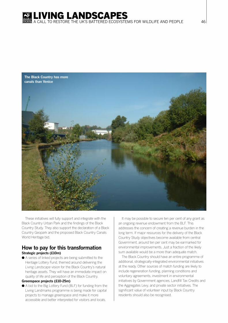
46LIVING LANDSCAPESA CALL TO RESTORE THE UK’S BATTERED ECOSYSTEMS FOR WILDLIFE AND PEOPLE
These initiatives will fully support and integrate with the Black Country Urban Park and the findings of the Black Country Study. They also support the declaration of a Black Country Geopark and the proposed Black Country Canals World Heritage bid.
How to pay for this transformationStrategic projects (£10m)● A series of linked projects are being submitted to the
Heritage Lottery Fund, themed around delivering the Living Landscape vision for the Black Country’s natural heritage assets. They will have an immediate impact on quality of life and perception of the Black Country.
Greenspace projects (£10-25m)● A bid to the Big Lottery Fund (BLF) for funding from the
Living Landmarks programme is being made for capital projects to manage greenspace and make it more accessible and better interpreted for visitors and locals.
It may be possible to secure ten per cent of any grant as an ongoing revenue endowment from the BLF. This addresses the concern of creating a revenue burden in the long term. If major resources for the delivery of the Black Country Study objectives become available from central Government, around ten per cent may be earmarked for environmental improvements. Just a fraction of the likely sum available would be a more than adequate match.
The Black Country should have an entire programme of additional, strategically-integrated environmental initiatives at the ready. Other sources of match funding are likely to include regeneration funding, planning conditions and voluntary agreements, investment in environmental initiatives by Government agencies, Landfill Tax Credits and the Aggregates Levy, and private sector initiatives. The significant value of volunteer input by Black Country residents should also be recognised.
The Black Country has more canals than Venice

47LIVING LANDSCAPESA CALL TO RESTORE THE UK’S BATTERED ECOSYSTEMS FOR WILDLIFE AND PEOPLE
Turning round perceptionsThe Local Biodiversity Action Plan (BAP) is the touchstone that guides all sectors in their work to protect and enhance wildlife and natural habitats. The development phase of Living Landscape will take place alongside a review of the BAP. With implementation, it will provide resources to support a step-change in Biodiversity Action Plan delivery.
Practical projects to encourage rare and iconic species such as otters, bluebells, peregrines, black redstarts, orchids and water voles will emphasise the wildlife value of the Black Country. Management of priority habitats such as ancient woodlands, wildflower grasslands, heathland, rivers, canals, streams and other water bodies will also help turn around the area’s image.
Enhancements to less valued habitats, such as managing and introducing wild flowers to recently-planted woodland, will also result in overall improvements to the quality and perception of the environment.
The project aims to create endless opportunities for environmental enhancement. It will also provide expert help advising landowners and land managers on the best ways to encourage and promote biodiversity.
By engaging communities in the management of Local Wildlife Sites, and in recording and appreciating their local wildlife, they will gain greater understanding and ownership of natural assets. The project will therefore deliver measurable improvements across all the Black Country’s BAP targets and achieve the habitat targets in the Regional Spatial Strategy. As the reputation and profile of the project and its achievements grow, the Black Country will gain a reputation for environmental quality.
Specific proposals● A BAP co-ordinator to monitor and record the actions
that will accompany the transformation of the Black Country’s natural environment.
● A local flagship project on the River Tame at Wednesbury, developing sustainable end uses while encouraging biodiversity and providing accessible greenspace.
● A national flagship project at Fenns Pools LNR to bring major ecological and community benefits, creating a nature reserve to attract visitors from outside the region.
● A national flagship project on the River Stour using ecological techniques to improve water quality while providing wildlife habitat and transforming the landscape.
● A national flagship project at Sheepwash, with a showcase eco-park and visitor centre, and ambitious work to re-link to the nearby river and canal, while improving connectivity with local communities.
● A ‘Habitat Creation and Enhancement Unit’ bringing together the skills and experience of land managers across the Black Country, to promote best practice.
● Environmental improvement projects across the area.
The Geopark componentThe Black Country landscape, cultural heritage and natural areas are ideal for the establishment of a Black Country Geopark. We think of the Black Country’s geodiversity as the link between people, landscape and their culture; the variety of geological environments, phenomena and processes that make the landscape, rocks, minerals, fossils and soils which provide the framework for life on earth.
To recognise the area’s incredible heritage a Black Country Geodiversity Action Plan (BCGAP) steering group was set up in 2004 to ensure that a partnership existed across the Black Country to identify, promote and make accessible the wealth of geological, geomorphological and mining heritage features of the sub region.
Specific proposals● A high-profile public launch for the BCGAP, with the
support of a geodiversity co-ordinator.● Establishment of the Black Country Geopark, and site-
based projects and events within it.● A local flagship project at Doulton’s Claypit, with major
improvements to accessibility and interpretation.● A national flagship project at Wren’s Nest National Nature
Reserve, incorporating the ground-breaking ‘trilobuilding’ visitor centre.
Accessible natural greenspaceThe Regional Spatial Strategy reiterates the national standards for accessible natural green space: safe, well managed, accessible places, attractive and rich in wildlife that everyone can enjoy.
Living Landscape will include a major capital programme to help the Black Country achieve these targets. It will promote existing accessible wildlife sites to local people, for example by providing more Community Liaison Officers for Local Nature Reserves. Where there are existing wildlife sites that people can or do not use, the project will make them more accessible and attractive.
Where there are spaces that are not achieving their potential for wildlife, projects to enhance their habitat value without compromising their other functions will be put in hand. In areas of the lowest environmental quality, the project will create new, accessible, multi-functional wildlife-rich green spaces from scratch.

48LIVING LANDSCAPESA CALL TO RESTORE THE UK’S BATTERED ECOSYSTEMS FOR WILDLIFE AND PEOPLE
This programme will be led by the local authorities, as the main landowners, addressing the priority sites and actions they have already identified. Existing open space strategies and audits will be the starting point for all the Living Landscape proposals. Throughout this work a high priority will be the engagement and consultation of all sectors of local communities.
Specific proposals● The designation of new Local Nature Reserves to benefit
communities in every borough.● A local flagship project at Cuckoo’s Nook, improving
public access and linking to Walsall Arboretum and the Beacon Way.
● A local flagship project to re-establish pedestrian and cycle access to the Tettenhall Ridge.
● A viewing platform and visitor centre at Warley Water Tower as a regional flagship project.
● An international flagship project to create a footpath/cycleway between West Bromwich and Walsall, taking in the best of the Sandwell Valley.
● Achieving the RSS Accessible Natural Greenspace (ANG) standards for the whole Black Country.
● Reaching groups and communities historically excluded from engagement with the natural environment.
Lifelong learningEvery schoolchild in the Black Country should have access to high-quality environmental education. If our citizens understand their environmental rights and responsibilities they will support and be active participants in achieving the sustainable vision for the Black Country.
The natural greenspaces of the Black Country are a huge but under-used resource for out-of-classroom learning. Physical improvements to accessible natural greenspace will increase opportunities for schools. Environmental education can support many areas of the national curriculum, from literacy and numeracy to citizenship.
To achieve our vision, we will need people with the skills and knowledge to manage our natural assets. Living Landscape will train local people with the skills to take an active role in the area’s environmental regeneration.
In the long term the ongoing management of the Black Country Urban Park will create the need for local jobs in environmental management. There will also be a need for people with the skills to interpret the local heritage for visitors. We must ensure that local people have the skills and experience to secure these jobs. The project will also encourage new business start-ups in the areas of environmental management and environmental tourism.
Specific proposals● Take best practice in environmental education in the
Black Country and make support available to all schools.● Establish training programmes in environmental skills.● Make sure all the flagship projects achieve the highest
standards of interpretation, so that the whole community can appreciate and understand their significance.
● Have environmental education as an integral part of each schools curriculum.
● Establish the skills base for a thriving environmental management sector in the Black Country economy, maximising the use of local labour and skills.
TourismThe Black Country already has many fine ‘industrial heritage’ attractions. Geotourism and ecotourism are natural extensions of this heritage based sub-sector. The establishment of a Black Country Geopark is likely to create an immediate and sustained increase in geotourism.
Much of the Black Country is already beautiful and rich in wildlife; it just has a bad reputation

49LIVING LANDSCAPESA CALL TO RESTORE THE UK’S BATTERED ECOSYSTEMS FOR WILDLIFE AND PEOPLE
As part of its ambitions for the Black Country canals, British Waterways wishes to double the number of towpath users. The wildlife and natural aspects of the canal network, along with its industrial heritage, make it an obvious focus for tourism. If the canals achieve World Heritage Site status, the number of visitors will increase even further.
The Sandwell Valley is already a major tourism destination. We can extend and improve the number of such destinations in the Black Country, increasing visitor spend and improving the image of the area.
Long distance footpaths, such as the proposed Tame Valley Walkway, and local trails and accessible sites, will further increase leisure and tourism opportunities.
Most importantly, once the Black Country’s environment starts attracting significant numbers of visitors, there will be a better and wider understanding of the quality of its environment, and in turn the environment will be better appreciated and valued by those who live here.
Specific proposals● Complete and publicise the Tame Valley Walkway.● Introduce ‘Black Country Urban Safaris’.● Appoint an environmental tourism officer for Black
Country Tourism to research and promote the area’s potential as a natural heritage destination.
● Invest in Walsall Arboretum as a regional flagship project.● Establish the Black Country as a recognised tourist
destination for natural heritage holidays, with at least a seven figure annual value.
● Build an iconic visitor centre at Barr Beacon as a regional flagship.
● Realise the potential of the Sandwell Valley as a natural heritage asset.
● Create a West Bromwich to Walsall footpath/cycleway.● Develop flagship wildlife reserves with visitor centres and
interpretation to attract tourists and visibly demonstrate environmental quality in each borough.
HealthThrough outdoor recreation and getting communities involved in managing their local environment, Living Landscape will promote healthy lifestyles.
Events and informal recreation will encourage more and more people to enjoy the Black Country’s natural assets. Multi-functional corridors, as well as attracting and supporting wildlife, will provide safe, attractive and well-used routes for footpaths and cycleways between local centres. For the more active, management of local open spaces will provide opportunities for volunteering.
Natural habitats also have positive psychological effects, and improve air and water quality, directly benefiting the health of residents. Accessible natural greenspace close to hospitals has been shown to help recovery.
Wildlife and the natural environment will provide a resource for projects working with patients in need of rehabilitation, or with mental health problems.
Specific proposals● Further develop ‘Ground Miles’ and ‘Healthy Walking’,
using the natural environment as a lever to encourage participation.
● Increase opportunities for volunteer work on environmental projects.
● Establish safe walking and cycling routes along multi-functional corridors, enabling the natural environment to link and support the urban centres and corridors.
● Make Green Gyms™ available in all major public parks and employment centres, such as the West Park regional flagship project.
● Add new pedestrian and cycle links in the Wolverhampton Technology Corridor.
● Offer environmental initiatives for the benefit of people with mental health problems.
Taking Living Landscape forwardLiving Landscape builds on existing initiatives and best practice in the Black Country, while seeking to co-ordinate the efforts of everyone working to improve the environment and promote and share best practice.
Living Landscape will send a clear message that the Black Country is serious about transforming its environment, not just by 2030, but achieving major visible changes and benefits within the rest of this decade. By the end of 2006 proposals must be submitted to secure development funding from various sources, including the Heritage Lottery Fund and the Big Lottery Fund, as well as several Government agencies. To do this we must be able to demonstrate that, if the resources are made available, the Black Country can deliver.
The enthusiastic support of the four local authorities, and the other sectors represented by members of the Black Country Consortium, is essential.
If we succeed in securing such resources for the Black Country’s natural environment, then we have the opportunity to do something which every other urban area in the world will watch with interest.

50LIVING LANDSCAPESA CALL TO RESTORE THE UK’S BATTERED ECOSYSTEMS FOR WILDLIFE AND PEOPLE
The project visionTo walk in wonderful wild countryside all day without retracing your steps, among habitats and species that cannot be seen anywhere else on this scale.
Nowhere in lowland England is this yet possible, but it is the vision of the Great Fen Project (GFP): to recreate an inspirational landscape not seen in England on such a scale since the 17th century. It will take a lifetime to complete and will last forever, a living legacy for future generations.
How the project worksThe GFP is a partnership between Natural England, the local Wildlife Trust, Huntingdonshire District Council and the
Environment Agency. It is restoring over 3,700 hectares of fenland from arable land between Huntingdon and Peterborough. This will safeguard isolated and diminishing fen species and their unique and valuable habitat, which is so rare throughout the world.
The project will connect Woodwalton Fen National Nature Reserve with Holme Fen National Nature Reserve. Neither of these important sites is sustainable at their present size, due to intensive arable cultivation around them and uncontrollable water levels. The Great Fen Project will halt the deterioration of both reserves and improve the whole area so much for wildlife that new species will breed there.
What has been described in the national media as ‘the most important conservation project in the UK for 100
The Great Fen ProjectCreating a wonderful wetland with huge social and economic benefitsChris Gerrard Great Fen project manager, The Wildlife Trust for Beds, Cambs, Northants and Peterborough
Few people realise that this is the true landscape of the fens: a shifting mosaic of
mixed wetland, woodland, reedbed, meadow and scrub

51LIVING LANDSCAPESA CALL TO RESTORE THE UK’S BATTERED ECOSYSTEMS FOR WILDLIFE AND PEOPLE
years’ will also have a very positive impact upon land and water management and the rural economy in the region.
Over £6.7 million has already been raised and committed to this long term project, but the project partners need to raise a further £11 million over the next five years for continued land acquisition, restoration and management, and visitor facilities and programmes.
The loss of the fensThe development of agriculture and urban growth have resulted in the loss of countryside and wildlife habitat in the UK. Cambridgeshire has been particularly badly affected,
but nowhere is the problem more severe than in the Fens. 400 years ago the Fens was a beautiful and vast complex
of rivers, streams, wet grassland, woodland, raised bog, reed beds and fens, providing a bountiful source of food and natural resources for the people that lived there and an unrivalled habitat for wildlife. The result was one of the most prosperous areas in England, and an example of truly sustainable land use.
From the 17th century onwards the area was successively drained (often against the will of local people), usually by venture capitalists seeking to make profits by creating more valuable grazing and arable land. As the drainage continued, wild habitats used by local people were lost and this has

52LIVING LANDSCAPESA CALL TO RESTORE THE UK’S BATTERED ECOSYSTEMS FOR WILDLIFE AND PEOPLE
continued to the present day. Since 1600, over 99.9 per cent of the original ancient few has been lost from the Fens. The tiny fragments that remain are in danger of drying out.
Wildlife-rich habitats of cultural and historic value have been lost along with species that depend on them, such as the large copper butterfly, which became extinct in Britain when it disappeared from the Cambridgeshire Fens and Norfolk Broads. Much of the GFP area is now below sea level because the peat soil has shrunk through water loss and oxidation. In fact the peat, which has taken thousands of years to develop, and is as unique and limited a natural resource as coal and oil, is being lost in this area at a rate of 1.5-2 centimetres per year.
A county on the brinkThe average area of land designated as SSSI (Site of Special Scientific Interest) in England is 6.8 per cent. The figure for Cambridgeshire is 2.7 per cent, and is lower still in the Fens. The few remaining sites of wildlife value are small and fragmented.
Woodwalton Fen in the south of the GFP area (see map on previous page) is internationally important for its communities of wetland plants and animals. It is also one of Britain’s oldest nature reserves, having been purchased by the Hon. Charles Rothschild in 1910.
Holme Fen is protected for its peat and bog remains and birch woodland. However, both of these reserves are under serious threat from the effects of unsustainable surrounding land use – ‘islands’ in a deteriorating countryside.
Problems with current land useThe Fens was once one of the most prosperous areas in England, as evidenced by the wealth of cathedrals, churches and abbeys. Now, however, it suffers from a range of deprivation and provides little opportunity for access, recreation, education or enjoyment of the countryside. There are no National Parks or Areas of Outstanding Natural Beauty, and fewer than half the public footpaths of other landscapes in the county. The market town of Ramsey, on the eastern side of the GFP, is performing poorly according to socio-economic measures such as housing, employment and access to services.
Moreover, the Cambridgeshire Fens now requires constant draining – much of the area is below sea level because the peat has shrunk so dramatically. The area is under constant threat of flood and water levels need to be continually managed. This risk will only increase with global warming.
How the GFP will be differentLand useBy discontinuing artificial drainage and replacing it with appropriate wetland management, the project will improve capacity for the storage of winter water, which could reduce flood risk in the area. Much of the land will be managed more extensively, allowing the landscape to reassert itself and create a diversity of habitats, which will be grazed by large herbivores such as wild horses and highland cattle. Other areas could see the return of traditional cropping such as reeds for thatching or hay for power generation.
RecreationA rapidly growing county needs new green spaces for people to enjoy the open air. Quiet recreation supports mental and physical well-being – breathing space in beautiful countryside. The Great Fen Project will go further than that, however, by creating a landscape for learning. Education work at Woodwalton Fen and nearby Ramsey Heights Countryside Classroom will be expanded for all ages, to include species identification and natural history, habitat restoration, historical ecology and local social history.
Rural tourism and regional regenerationWith such a large site, the local community and visitors will discover an unprecedented access to the countryside. The Great Fen runs alongside the east coast main line and is within two miles of the A1. Peterborough, Huntingdon and Cambridge are all within 20 miles. Pathways and facilities will be suitable for people with disabilities, and there will be opportunities to explore on horseback, cycle and boat.
The GFP will increase local, national and international tourism and generate income for local businesses – such as hotels, B&Bs and restaurants. This will provide a much-needed boost to the local economy. Through management for wildlife conservation, there will be opportunities for organic meat and dairy products, reed harvesting, and grass and hay production. Management of the nature reserve itself will also provide both paid work and volunteering opportunities.
Protection for the futureThe Great Fen Project will give future generations the chance to experience fenland landscapes, habitats and species that will otherwise be lost forever. It will be a living landscape with a thriving, prosperous human population – regenerating the Fens for the 21st century.
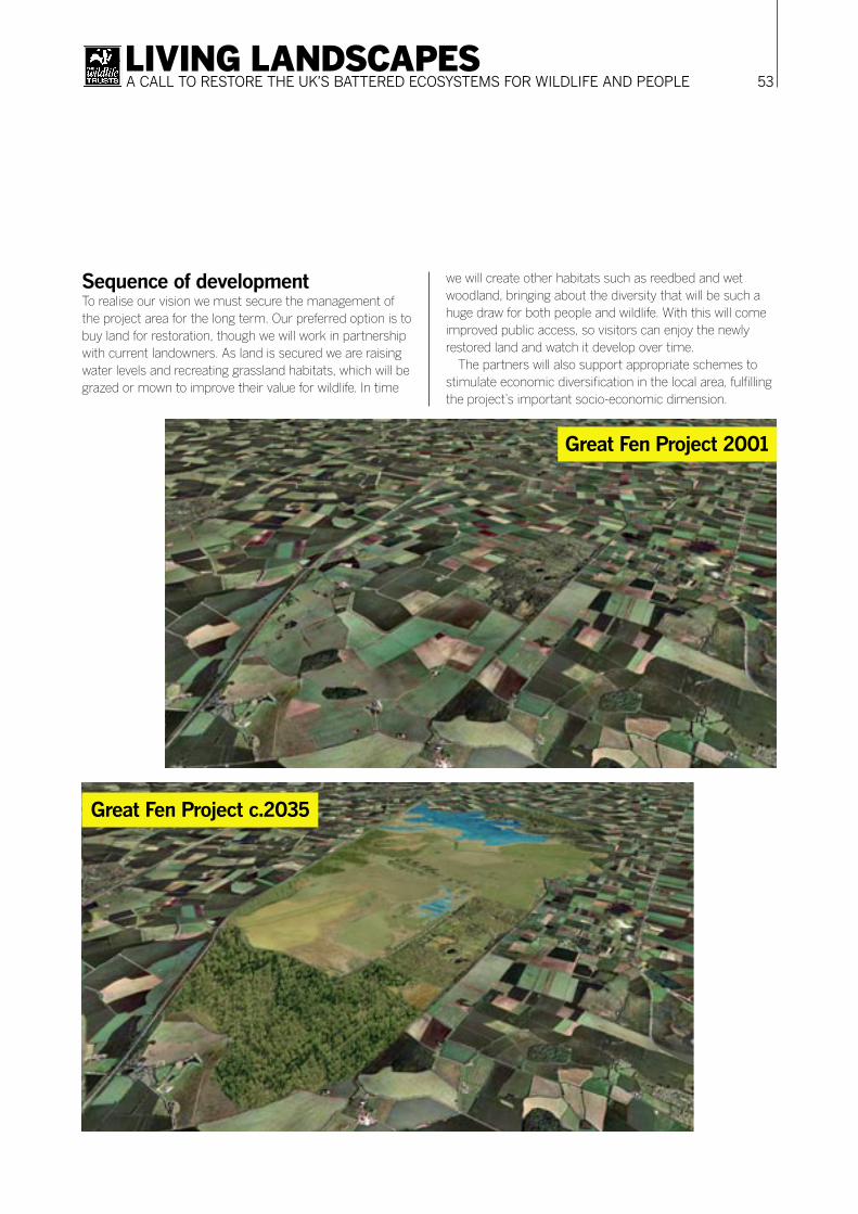
53LIVING LANDSCAPESA CALL TO RESTORE THE UK’S BATTERED ECOSYSTEMS FOR WILDLIFE AND PEOPLE
Sequence of developmentTo realise our vision we must secure the management of the project area for the long term. Our preferred option is to buy land for restoration, though we will work in partnership with current landowners. As land is secured we are raising water levels and recreating grassland habitats, which will be grazed or mown to improve their value for wildlife. In time
we will create other habitats such as reedbed and wet woodland, bringing about the diversity that will be such a huge draw for both people and wildlife. With this will come improved public access, so visitors can enjoy the newly restored land and watch it develop over time.
The partners will also support appropriate schemes to stimulate economic diversification in the local area, fulfilling the project’s important socio-economic dimension.
Great Fen Project 2001
Great Fen Project c.2035
54LIVING LANDSCAPESA CALL TO RESTORE THE UK’S BATTERED ECOSYSTEMS FOR WILDLIFE AND PEOPLE
Progress to dateThe GFP is well established and has taken its first vital steps. The project partners appointed a Great Fen Project Manager in 2001 and commissioned feasibility studies encompassing ecology, socioeconomics, access, hydrology, archaeology and soil analysis.
The project partners have been working closely with local people, consulting on aspects of the project and raising awareness, as well as approaching landowners to gauge their interest in and support for the project. Most are interested and receptive and willing to work with the project.
Two pieces of land have been purchased by the Great Fen Project to date – Darlow’s Farm (83 hectares) in December 2002 and 31 hectares adjacent to Holme Fen in early 2005. We continued to farm Darlow’s Farm for two years to reduce the nutrient content of the soil, and are now re-establishing high quality grassland by re-seeding and managing water levels to create a much wetter environment. Acquiring the land adjacent to Holme Fen allows us to significantly improve hydrological conditions in the existing nature reserve.
The Great Fen Project partners have already raised and committed over £6.7 million for the project to date, and have now embarked on a structured fundraising campaign to raise £11 million over the next three years for land purchase, restoration and other project costs. The Project is beginning to attract the attention of national and local media.
If funds are not raised…It is imperative to act now – if funds are not raised, Woodwalton Fen and Holme Fen would continue to decline, losing valuable rare habitats and threatened species. Eventually they would cease to be of such value for wildlife or for local people and visitors to enjoy. The peat would continue to be lost, and will eventually run out. The habitats and species unique to peat will never be able to be recreated. Water management for the Great Fen area will need to intensify as global warming takes effect. Most importantly, if fundraising fails the opportunity will be lost to create a special, unique and vast landscape for the benefit of wildlife, people and the local economy.
Thank you to the following organisations for generously supporting the Great Fen Project:
● Atack van Someren Charitable Trust● Biffaward● Chadwyck-Healey Charitable Settlement
● Charles Hayward Foundation● Department for Communities and Local Government● Environment Agency● Ernest Kleinwort Charitable Trust● Esmée Fairbairn Foundation● Fenside Waste● Garfield Weston Foundation● Grantscape Biodiversity Challenge Fund● Henry C Hoare Charitable Trust● Heritage Lottery Fund● Huntingdonshire District Council● Miss AC Martin Will Trust● Natural England● Peter Boizot Foundation● Ramsey Area Partnership● The Rothschild Foundation● The Wildlife Trust● Tubney Charitable Trust● Wildlife Travel● World Wildlife Fund

55LIVING LANDSCAPESA CALL TO RESTORE THE UK’S BATTERED ECOSYSTEMS FOR WILDLIFE AND PEOPLE
BackgroundThe Low Weald of West Sussex and southern Surrey is a diverse landscape of ancient woodland, wildfl ower glades and other wildlife-rich semi-natural habitats that have survived over the centuries where elsewhere they have been largely lost.
The West Weald is one of the best-wooded parts of the UK, almost a third of the area being covered by different woodland types and 20 per cent being ancient woodland, much of it a remnant of the post-glacial wildwood. The area contains internationally important examples of old-growth forest and pasture woodland. In the heart of this landscape Sussex Wildlife Trust (SWT) owns and manages two nature reserves: The Mens and Ebernoe Common. Chiddingfold Forest straddles the Sussex-Surrey border in the north. It’s
an area of production forest managed by Forest Enterprise with due regard to its signifi cant wildlife interest.
Nationally and internationally important populations of rare species are present, including bats, woodland butterfl ies and important lichens and fungi. Indeed, Ebernoe Common is recognised as the most important site for bats in the UK, with 14 of the UK’s 16 species – most notably the rare barbastelle and Bechstein’s bats.
Some of these important species depend on a diverse network of well-connected habitats, maintained by both natural and human processes. Barbastelle bats need woodland interconnectivity and dense hedgerow cover to connect roost sites with feeding areas, and the fragmented Pearl-bordered fritillary butterfl y colonies exist as metapopulations that need ‘permeable’ semi-natural vegetation between colonies.
The West Weald Landscape ProjectWorking towards a naturally functioning landscape for wildlife and peopleRich Howorth West Weald landscape project manager, Sussex Wildlife Trust
Sussex Wildlife Trust’s long-term woodland mosaic
project aims to safeguard around 4,400 species of plant
and animal

56LIVING LANDSCAPESA CALL TO RESTORE THE UK’S BATTERED ECOSYSTEMS FOR WILDLIFE AND PEOPLE
Whilst these forest patches are set within a matrix of less wildlife-friendly countryside (mainly arable agriculture covers more than half of the landscape), the West Weald is one of the few areas of lowland England that retains some aspects of a functioning forest landscape. It thus presents a significant opportunity to further enhance the viability of this incredible natural resource.
Project AreaOur initiative covers 93 square miles at the western end of the Low Weald, primarily on acidic clay soils north of Petworth in West Sussex. The project area (outlined in red on the map opposite) is bounded by the Rother river valley in the south and Upper Arun river valley in the east, with a greensand ridge forming a loose demarcation in the west and north.
The three key areas of designated conservation interest (Ebernoe Common and The Mens – both National Nature Reserves and Special Areas of Conservation – and Chiddingfold Forest – a SSSI) range from extensively grazed pasture woodland to a non-intervention regime and actively managed high forest. Other designated sites in the project area include the Northpark Copse to Snapelands Copse SSSI woodland area on the south-western greensand ridge, and the wetland Upper Arun SSSI at the eastern edge. There are also a multiplicity of diverse habitat patches, including designated sites, non-designated sites, other semi-natural vegetation and a variety of interconnecting habitats.
The processes driving the habitat pattern in the area vary, and include:● Relatively intensive traditional woodland management;● Pasture woodland management in commons, roadside
verges and common woodland;● Non-intervention and the development of old growth
forest, both intentionally and as a result of the cessation of woodland management in many stands.Low-intensity management of other semi-natural
vegetation also helps to provide reasonable general permeability for species movement throughout this landscape.
The story so farThe project is a central plank of a pioneering approach first set out in SWT’s Vision for the Wildlife of Sussex, published in 1996, which outlined new concepts for landscape scale management using natural processes.
SWT is putting its ideas into practice, with support from the Heritage Lottery Fund and others, by consolidating and
expanding its reserves as part of the fabric of broad ecological networks. In 2001, SWT bought 80 hectares of mainly arable land, Butcherland Farm, adjacent to Ebernoe Common. Subsequent management with low-intensity cattle grazing is promoting natural reversion through grassland to a future pasture woodland complex which will complement Ebernoe’s reinstated grazed pasture woodland.
The expanded Ebernoe should make it easier to balance the competing species interests of the site; since the Trust tried to reinstate the previous more open pasture woodland mosaic, conflicts have arisen with the recently-discovered, internationally-important bat populations that depend on the contemporary denser forest environment.
The Ebernoe experience, based on careful extensive naturalistic grazing supported by effective monitoring, lies at the core of our vision for the wider area. We hope it will serve as a model for extension into the wider environment.
Sussex Wildlife Trust’s West Weald project area builds on a fabulous forest inheritance from the distant past
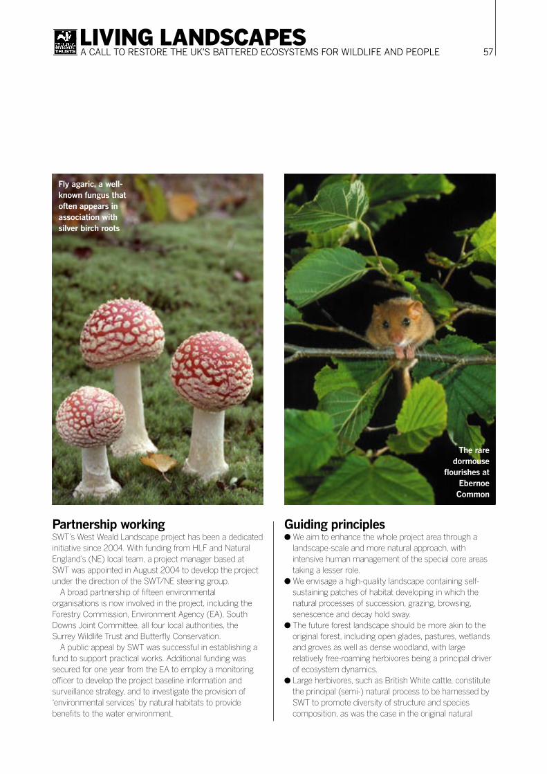
57LIVING LANDSCAPESA CALL TO RESTORE THE UK’S BATTERED ECOSYSTEMS FOR WILDLIFE AND PEOPLE
Partnership workingSWT’s West Weald Landscape project has been a dedicated initiative since 2004. With funding from HLF and Natural England’s (NE) local team, a project manager based at SWT was appointed in August 2004 to develop the project under the direction of the SWT/NE steering group.
A broad partnership of fifteen environmental organisations is now involved in the project, including the Forestry Commission, Environment Agency (EA), South Downs Joint Committee, all four local authorities, the Surrey Wildlife Trust and Butterfly Conservation.
A public appeal by SWT was successful in establishing a fund to support practical works. Additional funding was secured for one year from the EA to employ a monitoring officer to develop the project baseline information and surveillance strategy, and to investigate the provision of ‘environmental services’ by natural habitats to provide benefits to the water environment.
Guiding principles● We aim to enhance the whole project area through a
landscape-scale and more natural approach, with intensive human management of the special core areas taking a lesser role.
● We envisage a high-quality landscape containing self-sustaining patches of habitat developing in which the natural processes of succession, grazing, browsing, senescence and decay hold sway.
● The future forest landscape should be more akin to the original forest, including open glades, pastures, wetlands and groves as well as dense woodland, with large relatively free-roaming herbivores being a principal driver of ecosystem dynamics.
● Large herbivores, such as British White cattle, constitute the principal (semi-) natural process to be harnessed by SWT to promote diversity of structure and species composition, as was the case in the original natural
Fly agaric, a well-known fungus that often appears in association with silver birch roots
The rare dormouse
flourishes at Ebernoe
Common
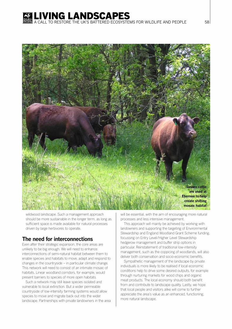
58LIVING LANDSCAPESA CALL TO RESTORE THE UK’S BATTERED ECOSYSTEMS FOR WILDLIFE AND PEOPLE
wildwood landscape. Such a management approach should be more sustainable in the longer term, as long as sufficient space is made available for natural processes driven by large herbivores to operate.
The need for interconnectionsEven after their strategic expansion, the core areas are unlikely to be big enough. We will need to enhance interconnections of semi-natural habitat between them to enable species and habitats to move, adapt and respond to changes in the countryside – in particular climate change. This network will need to consist of an intimate mosaic of habitats. Linear woodland corridors, for example, would present barriers to species of more open habitats.
Such a network may still leave species isolated and vulnerable to local extinction. But a wider permeable countryside of low-intensity farming systems would allow species to move and migrate back out into the wider landscape. Partnerships with private landowners in the area
will be essential, with the aim of encouraging more natural processes and less intensive management.
This approach will mainly be achieved by working with landowners and supporting the targeting of Environmental Stewardship and England Woodland Grant Scheme funding, focussing on Entry Level/Higher Level Stewardship hedgerow management and buffer strip options in particular. Reinstatement of traditional low-intensity management, such as the coppicing of woodlands, will also deliver both conservation and socio-economic benefits.
Sympathetic management of the landscape by private individuals is more likely to be realised if local economic conditions help to drive some desired outputs, for example through nurturing markets for wood chips and organic meat products. The local economy should both benefit from and contribute to landscape quality. Lastly, we hope that local people and visitors alike will come to further appreciate the area’s value as an enhanced, functioning, more natural landscape.
Sussex cattle are used at
Ebernoe to help create shifting mosaic habitat
59LIVING LANDSCAPESA CALL TO RESTORE THE UK’S BATTERED ECOSYSTEMS FOR WILDLIFE AND PEOPLE
Project objectivesSpecifics are still being developed, but provisionally are likely to focus on four main aspects:
1. Core areas: consolidation, enhancement and expansion; 2. Whole landscape: improved habitat linkages and
integrated land management;3. Scientific knowledge: increased understanding of
landscape natural dynamic processes;4. Understanding and support: greater engagement of
people in the vision and realisation of a more natural landscape.
This is how we aim to stabilise and enhance the biodiversity of the core forest areas, whilst working across the wider countryside to encourage more sympathetic and integrated land management according to a landscape ecology approach. We are adopting a strong emphasis on scientific method and targeted research. Much work remains to be done to address the integration of the project with people and the cultural environment, although this will clearly be essential to underpinning the project’s success over time.
The main elements above will form a longer-term funding proposal to enable implementation to fully commence on the ground. In the meantime, we have begun a number of activities to set the stage for practical work:
Baseline audit of biodiversityAn extensive analysis of available information on sites, habitats and species has been undertaken, using site survey and Phase 1 habitat survey information, as well as almost 80,000 species records held by Sussex and Surrey Biological Records Centres. The West Weald is thus known to contain more than 4,400 species, or about ten per cent of the UK’s terrestrial wildlife, with a high diversity of vascular plants, butterflies, dragonflies, herptiles and mammals in particular.
Geographical coverage of recording is significantly skewed to ‘honeypot’ sites for most species groups, with the wider countryside generally poorly surveyed. Many of the species are of conservation interest, with 95 listed in the UK Biodiversity Action Plan, and 250 being nationally scarce. Further analysis of BAP species has been undertaken to ascertain habitat affiliations and principal threats/management needs of listed taxa, with both over- and under- management being significant in most habitats. This analysis of baseline biodiversity information will underpin grant scheme targeting. and identify priority wildlife and sites for action.
Information on landscape ecology indices, other environmental resources (e.g. water and soils), and socio-economic and cultural elements is now being assembled to present a complete ‘State of the Natural Environment’ assessment of the West Weald.
Survey and research We have started a major programme of field research to fill critical gaps in knowledge, using SWT staff, contractors and volunteers. In this way, issues such as the natural development of Butcherland Farm’s fields, and cattle/bat roost interactions at Ebernoe Common, are now yielding valuable results.
Conservation enhancementsWe have improved identified Barbastelle bat flightlines on SWT’s expanded Ebernoe reserve, through hedge planting and restoration. We have established new wetland foraging areas by infilling drainage ditches to allow inundation, and hold water up on the land.
Landowner liaisonWe have run workshops for farmers in the project area with FWAG to promote the project vision and appropriate agri-environment options. We have advised several individual landowners on land management and grant support.
Project disseminationWe have explained the project to interested audiences through talks, walks, events, the project website (westweald.org.uk), an advisory leaflet for landowners and a set of high-impact display panels. These centre on Barbastelle bats’ use of the wider environment as a flagship species for landscape connectivity.

60LIVING LANDSCAPESA CALL TO RESTORE THE UK’S BATTERED ECOSYSTEMS FOR WILDLIFE AND PEOPLE
A pioneering islandThe island of Eigg is one of the Small Isles, set in the Seas of the Hebrides 13 miles off the north west coast of Scotland. It represents an excellent example of a large-scale conservation project in both spatial and social dimensions.
Eigg is not the largest of the Small Isles but it is the most diverse. It extends to 3000 hectares, rises from sea level to 393 metres on the summit of An Sgurr, and is made up of forest, farm and crofting land. It has a diverse flora with machair, coastal heath, species-rich grassland and artic-alpine assemblages, to name but a few. There are 16 nationally important species of plant recorded, numerous bird species including golden eagle, a raised bog and significant areas of natural hazel scrub.
A revolution in land ownershipThe island was one of the early successful community land purchases. It was a revolution in land ownership in
Scotland, and saw the Eigg community (assisted by the Scottish Wildlife Trust, SWT) raise a million pounds to purchase the land where they live and work. The Isle of Eigg Heritage Trust (IEHT) now owns and manages the island, its three farms and two crofting communities, as well as its policy and plantation woodlands. SWT is represented on the IEHT board and can therefore input to decisions which affect wildlife on the Island.
A long-term commitmentSWT has had a ranger on Eigg since the early 1980s. The current ranger, John Chester, celebrates his 20th season on Eigg this year. His knowledge of the island’s wildlife, people and way of life have been a vital ingredient in what has been achieved in natural heritage management over the years. It demonstrates the benefits that a long-term commitment to a place can yield. We also have over 20 years of annual reports of bird, plant and insect records – an invaluable natural history resource.
Landscape-Scale Conservation on the Isle of EiggA project driven and directed by the local communityStuart Brooks Head of conservation, Scottish Wildlife Trust
Eigg’s conversion to sustainable principles
through community action is a model for many future
landscape-scale schemes
61LIVING LANDSCAPESA CALL TO RESTORE THE UK’S BATTERED ECOSYSTEMS FOR WILDLIFE AND PEOPLE
An eco-restoration for all Over the last ten years very significant progress has been made to protect and enhance the natural and human heritage of the island. The island’s archaeology has been surveyed in great detail by the Royal Commission for Ancient and Historic Monuments, and evidence of man’s presence on Eigg since the earliest times found. An all-island National Vegetation Classification survey has also been completed. The first stages of a management plan to enhance Eigg’s forest land has been completed. The forest is now protected from overgrazing, and significant areas of exotic conifers have been felled to allow native species to regenerate. Blar Dubh, the island’s raised bog, has been cleared of conifers and the deep ploughlines blocked so it can re-wet. The islanders themselves, properly trained and equipped, completed this work.
In agriculture the IEHT recently rejuvenated the crofting landscape, rationalising existing crofts and creating new ones. The island farmers and crofters have enthusiastically engaged with the rural stewardship scheme, and will be carrying out a diverse range of activities to help wildlife.
The futureThe funding generated through forestry, agriculture and other heritage grants has been largely kept on the island. This has created work, increased skills, and played a part in stabilising the island’s population.
There is much more to do. We have another decade or so of forestry work to complete the conversion of lodgepole pine plantation to bearded willow wildland. We may well reintroduce targeted grazing into the woodland in the future. There are also significant opportunities to create new areas of woodland on marginal farmland, and to extend hazel scrub. And we have barely touched on the marine environment. Eigg is, after all, an island and may possibly form a part of Scotland’s first Marine National Park. We have barely begun to explore what lies off Eigg’s shores, though we can reasonably expect it to exceed the land in natural diversity.
And of course we can expect a comprehensive annual account of what is happening to biodiversity as change occurs, as we influence farming and forestry. and as the world warms up.