lagoons slip and slide - california department of ... slip and slide u.s ... array of 11 horizontal...
TRANSCRIPT

Lagoons Slip and Slide U.S. ROUTE 101 IN HUMBOLDT COUNTY
01-HUM-101 - PM 110.58/113.76
EA 0B420 / EFIS 0112000126
Initial Study with Mitigated Negative Declaration
Prepared by the State of California Department of Transportation
June 2015

For individuals with sensory disabilities, this document is available in Braille, large print, on audiocassette, or computer disk. To obtain a copy in one of these alternate formats, please call or write to Caltrans, Attn: Adele Pommerenck, Branch Chief, 703 B Street, Marysville, CA 95901; (530) 741-4215 Voice, or use the California Relay Service TTY number at 711.


Lagoons Slip and Slide Project 1
Section 1 – Proposed Project
Project Title
Lagoon Slip and Slide Project
Lead Agency & Project Sponsor’s Name, Address and Contact Person
California Department of Transportation
Attn: Adele Pommerenck, Branch Chief
703 B Street
Marysville, CA 95901
Project Location
The project locations are within and adjacent to Humboldt Lagoons State Park and the
Harry A. Merlo State Recreation Area on U.S. 101 in Humboldt County.
Purpose and Need
In March 2011, severe storm events resulted in two localized slope failures along the
southbound lane on U.S. 101. The purpose of this project is to restore and stabilize the
roadway to pre-storm damage conditions. The project is needed to repair the damaged
culverts caused by slope failures, and to prevent roadway failures from occurring in
future storm events.
Description of Project
The California Department of Transportation (Caltrans) proposes permanent restoration
to U.S. 101, at PM 110.58 (Location 1) and PM 113.76 (Location 2) in Humboldt
County. Work proposed at each of these locations is described in detail below.
Location 1 (PM 110.58)
U.S. 101 along the north side of Big Lagoon is built on geologically unstable uplifted
marine sediments. Maintenance of this section of highway has been problematic since
the establishment of this route in 1922. Various locations have failed due to the
unstable geology. The current location is approximately one (1) mile north of the
intersection of U.S. 101 and LP Mill Road (west of Tom’s Creek). The last time this
section failed was in 1982.
Proposed work at this location includes replacing the existing 90 foot long, 18-inch
diameter corrugated steel pipe (CSP) culvert that separated due to fill slope failure.
Culvert removal and installation is anticipated to be half-width construction (a
construction strategy wherein half of a symmetrical (or nearly so) roadway is
reconstructed (refurbished) as a phase without encroachment on the other half) with
one-way traffic control restrictions on U.S. 101 within the work area under flagging.

Lagoons Slip and Slide Project 2
The culvert outlet connects to a 35 foot long downdrain. The failed slope will be
excavated to prepare for replacement of the damaged downdrain. Placement of 0.25
ton Rock Slope Protection (RSP) at a 1:1.5 slope mixed with select imported fill will be
placed around the downdrain to fill in existing voids and provide for revegetation. Work
on the outlet (lagoon) side of the culvert will be accessed from U.S. 101. At the inlet
side of the culvert, proposed work includes replacing the drainage inlet and
reconnecting to an existing underdrain. Upon completion of the drainage work, the
roadway will be restored to existing conditions and disturbed soil areas will be
revegetated with native plant species.
Removal of Invasive Plants and Revegetation – Invasive jubata grass (Cortederia
jubata) will be removed within the project limits including an approximately 0.93 acre
area on the downslope side of the highway, above the lagoon. Removal will be done by
hand, and where accessible, by equipment. Native trees and shrubs will be protected if
at all possible. The tops of the Jubata grass will be cut with chainsaws and removed
from the site prior to the bird nesting season and prior to going to seed. The entire root
systems will then be removed (either by hand or with equipment) to minimize regrowth.
The site will then be prepped for planting, treated for erosion control and planted with
appropriate native species for the site.
Access
Work associated with the slope, the culvert, and the downdrain will be accessed from
the top of the slope from U.S. 101. A road providing access to the lagoon starts/begins
at approximately PM 110.5 and then runs along the lagoon beach in front of the project;
however, this road will not be used due to high water levels that cause overtopping,
making the road inaccessible.
Location 2 (PM 113.76)
The current alignment of U.S. 101 between Kane Road on the north end of Big Lagoon
and McDonald Creek, the primary tributary to Stone Lagoon, was established in 1971.
The highway alignment along the headlands between Big Lagoon and Stone Lagoon
was first established in 1922. Similar to Location 1, the highway in this area is built on
extremely unconsolidated and unstable uplifted marine sediments. Alignments of the
highway near Dry Lagoon were changed in 1938 and 1943. Major work was done in
1954 and 1955 and through the late 1950s and 1960s until the current alignment was
created.
The culvert at PM 113.79 conveys the water of a small drainage locally known as the
“Truttman Sink”. The fill prism constructed in 1971 is massive. The existing 42-inch
diameter CSP culvert at the bottom of the fill severely separated due to embankment
slope failure. Abandonment of the existing culvert and removal of the drainage inlet and
downdrain is recommended. Trenchless technique (drilling sub-horizontally through
roadway fill) for culvert installation has been recommended at this location. A 40 foot by

Lagoons Slip and Slide Project 3
40 foot jacking pit will be excavated adjacent to the existing culvert. The microtunnel
boring (drilling sub-horizontally through roadway fill) machine used to install the
proposed culvert will be located within the pit.
To dewater and stabilize the fill slope in this area, Caltrans proposes to install a radial
array of 11 horizontal drains from a 30 foot by 20 foot drilling pad located within the
Truttman Sink Maintenance Yard. The location of the horizontal drilling pad will be
approximately 100 feet northeast of the proposed “jacking” pit location.
After the bored culvert is installed, a drain inlet will be placed. The remainder of the
culvert to the downdrain will be placed by the cut and fill method. The drain inlet will
connect and carry the discharge from both the culvert and horizontal array. The
downdrain will be approximately 120 feet long and will remain unburied for future ease
of maintenance and to minimize disturbance to the steep slope and associated impacts
to trees and vegetation. The outlet of the downdrain will terminate into an approximately
23 foot by 10.5 foot rock energy dissipater within the Caltrans Right-of-Way. The area
within and around the rock energy dissipater and along the edge of the downdrain will
be vegetated with appropriate species.
At the culvert inlet (south of U.S. 101), an existing access road will be utilized for
transporting equipment and materials during construction. A cofferdam or similar
structure will be used to dewater the work area where the inlet with headwall will be
constructed. Any water diverted from the existing culvert will be carried by a small pipe
within the existing culvert. The diverted water will be piped along the Truttman Sink
Maintenance Yard access road and pumped to the nearest drain inlet to the northeast,
or a containment tank where sediment can settle. A right-to-enter permit has been
requested from State Parks for the removal of an existing riser (vertical extension to the
culvert which provides relief when the main entrance is plugged) (located outside of
Caltrans’ right-of-way) and also to allow the parking of contractor vehicles and
equipment along State Parks’ road located just downslope from Truttman Sink. The
inlet of the new culvert and headwall are located within Caltrans’ right-of-way. All
disturbed soil areas will be treated with erosion control and revegetated with appropriate
native plant species.
Staging, Storage and Disposal
All staging and storage will occur on previously-disturbed graveled pullouts adjacent to
the project area (Location 1) or within the Truttman Sink maintenance yard (Location 2).
If any excess fill is generated by the project, the contractor will be responsible for
identifying an approved and environmentally-cleared commercial site to which it will be
trucked.
Equipment fueling and temporary storage of waste materials (i.e. drill spoils) will occur
on-site and will be performed in accordance with current regulations and best

Lagoons Slip and Slide Project 4
management practices. An approved Storm Water Pollution Prevention Plan (SWPPP)
will be required, which will clearly identify specific fueling and waste handling locations
and procedures.
Traffic Control
During construction, temporary one-way traffic control restrictions and construction
warning signs will be installed to alert the traveling public within the work area. To
heighten motorist awareness of cyclists traveling within the construction zone, “Share
the Road” signs will be placed along the roadway and cyclists will be directed through
the temporary work zone during hours of construction.
Construction Schedule
Construction is estimated to take between 40 and 60 working days (one construction
season) depending on environmental restrictions and the type of trenchless culvert
installation determined to be necessary. The construction schedule will accommodate
special events and/or holiday schedules for the traveling public.
Surrounding Land Uses and Settings
Existing land use within the project area vicinity includes state park land, residential and
commercial land. No alteration to present or planned land use would occur as a result
of the proposed project.
Permits and Approvals Needed
The following environmental permits and approvals are required for this project:
• Federal Endangered Species Act Section 7 Consultation, U.S. Fish and Wildlife
Service and National Oceanic and Atmospheric Administration (NOAA Fisheries
Service)
• 401 Water Quality Certification, North Coast Regional Water Quality Control
Board
• Nationwide 404 Permit, United States Army Corps of Engineers
• 1602 Streambed Alteration Agreement, California Department of Fish and
Wildlife
• Humboldt County Local Coastal Development Permit
Zoning
The proposed project area is zoned as “Public Recreation” under the Humboldt County
General Plan and the North Coast Area Plan of the Humboldt County Local Coastal
Program.

Lagoons Slip and Slide Project 5

Lagoons Slip and Slide Project 6

Lagoons Slip and Slide Project 7
Section 2 – Environmental Factors Potentially Affected
The environmental factors checked below would be potentially affected by this project.
Please see the CEQA checklist for additional information. Any boxes not checked
represent issues that were considered as part of the scoping and environmental
analysis for the project, but for which no significant impacts were identified. Therefore,
no further discussion of these issues is in this document.
Aesthetics Agriculture and Forestry Air Quality
Biological Resources Cultural Resources Geology/Soils
Greenhouse Gas Emissions
Hazards and Hazardous Materials
Hydrology/Water Quality
Land Use/Planning Mineral Resources Noise
Paleontology Population/Housing Public Services
Recreation Transportation/Traffic Utilities/Service Systems
Mandatory Findings of Significance
Lagoons Slip and Slide Project 8
Section 3 – CEQA Checklist
01-HUM-101 110.58/113.76 01-0B420
Dist.-Co.-Rte. P.M/P.M. E.A.
This checklist identifies physical, biological, social and economic factors that
might be affected by the proposed project. In many cases, background studies
performed in connection with the projects indicate no impacts. A NO IMPACT
answer in the last column reflects this determination. Where there is a need for
clarifying discussion, the discussion is included either following the applicable
section of the checklist or is within the body of the environmental document itself.
The words "significant" and "significance" used throughout the following checklist
are related to CEQA impacts. The questions in this form are intended to
encourage the thoughtful assessment of impacts and do not represent thresholds
of significance.
Potentially Significant Impact
Less Than Significant with Mitigation
Less Than Significant Impact
No Impact
I. AESTHETICS: Would the project:
a) Have a substantial adverse effect on a scenic vista
b) Substantially damage scenic resources, including, but not limited to, trees, rock outcroppings, and historic buildings within a state scenic highway
c) Substantially degrade the existing visual character or quality of the site and its surroundings?
d) Create a new source of substantial light or glare which would adversely affect day or nighttime views in the area?
Explanation: “No Impact” and “Less than Significant with Mitigation” determinations in this section are based on the information provided in the Visual Impact Assessment dated September 17, 2014. Temporary visual effects will occur; however, with restoration and revegetation measures for the jubata site, the visual quality will be enhanced.
II. AGRICULTURE AND FOREST RESOURCES Would the project:
a) Convert Prime Farmland, Unique Farmland, or Farmland of Statewide Importance (Farmland), as shown on the maps prepared pursuant to the Farmland Mapping and Monitoring Program of the California Resources Agency, to non-agricultural use?
b) Conflict with existing zoning for agricultural use, or a Williamson Act contract?
c) Conflict with existing zoning for, or cause rezoning of, forest land (as defined in Public Resources Code section 12220(g)), timberland (as defined by Public Resources Code section 4526), or timberland zoned Timberland Production (as defined by Government Code section 51104(g))?

Lagoons Slip and Slide Project 9
Potentially Significant Impact
Less Than Significant with Mitigation
Less Than Significant Impact
No Impact
d) Result in the loss of forest land or conversion of forest land to non-forest use?
e) Involve other changes in the existing environment which, due to their location or nature, could result in conversion of Farmland, to non-agricultural use or conversion of forest land to non-forest use?
Explanation: The project is located within California State Parks’ boundaries; however, based on the scope, description, and location of the proposed project a “No Impact” determination is made in this section.
III. AIR QUALITY: Where available, the significance criteria established by the applicable air quality management or air pollution control district may be relied upon to make the following determinations. Would the project:
a) Conflict with or obstruct implementation of the applicable air quality plan?
b) Violate any air quality standard or contribute substantially to an existing or projected air quality violation?
c) Result in a cumulatively considerable net increase of any criteria pollutant for which the project region is non- attainment under an applicable federal or state ambient air quality standard (including releasing emissions which exceed quantitative thresholds for ozone precursors)?
d) Expose sensitive receptors to substantial pollutant concentrations?
e) Create objectionable odors affecting a substantial number of people?
Explanation: “No Impact” determinations in this section are based on the Air Quality Assessment Report dated March 28, 2014.
IV. BIOLOGICAL RESOURCES: Would the project:
a) Have a substantial adverse effect, either directly or through habitat modifications, on any species identified as a candidate, sensitive, or special status species in local or regional plans, policies, or regulations, or by the California Department of Fish and Wildlife or U.S. Fish and Wildlife Service?
b) Have a substantial adverse effect on any riparian habitat or other sensitive natural community identified in local or regional plans, policies, regulations or by the California Department of Fish and Wildlife or US Fish and Wildlife Service?
c) Have a substantial adverse effect on federally protected wetlands as defined by Section 404 of the Clean Water Act (including, but not limited to, marsh, vernal pool, coastal, etc.) through direct removal, filling, hydrological interruption, or other means?

Lagoons Slip and Slide Project 10
Potentially Significant Impact
Less Than Significant with Mitigation
Less Than Significant Impact
No Impact
d) Interfere substantially with the movement of any native resident or migratory fish or wildlife species or with established native resident or migratory wildlife corridors, or impede the use of native wildlife nursery sites?
e) Conflict with any local policies or ordinances protecting biological resources, such as a tree preservation policy or ordinance?
f) Conflict with the provisions of an adopted Habitat Conservation Plan, Natural Community Conservation Plan, or other approved local, regional, or state habitat conservation plan?
Explanation: “No Impact” determinations and “Less Than Significant with Mitigation” determinations in this section are based on information provided in the Natural Environment Study (NES) dated December, 2014, and discussed further in Section 4.
V. CULTURAL RESOURCES: Would the project:
a) Cause a substantial adverse change in the significance of a historical resource as defined in §15064.5?
b) Cause a substantial adverse change in the significance of an archaeological resource pursuant to §15064.5?
c) Directly or indirectly destroy a unique paleontological resource or site or unique geologic feature?
d) Disturb any human remains, including those interred outside of formal cemeteries?
Explanation: “No Impact” determinations in this section are based on the Cultural Resources Report dated September 15, 2014.
VI. GEOLOGY AND SOILS: Would the project:
a) Expose people or structures to potential substantial adverse effects, including the risk of loss, injury, or death involving:
i) Rupture of a known earthquake fault, as delineated on the most recent Alquist-Priolo Earthquake Fault Zoning Map issued by the State Geologist for the area or based on other substantial evidence of a known fault? Refer to Division of Mines and Geology Special Publication 42?
ii) Strong seismic ground shaking?
iii) Seismic-related ground failure, including liquefaction?

Lagoons Slip and Slide Project 11
Potentially Significant Impact
Less Than Significant with Mitigation
Less Than Significant Impact
No Impact
iv) Landslides?
b) Result in substantial soil erosion or the loss of topsoil?
c) Be located on a geologic unit or soil that is unstable, or that would become unstable as a result of the project, and potentially result in on- or off-site landslide, lateral spreading, subsidence, liquefaction or collapse?
d) Be located on expansive soil, as defined in Table 18-1-B of the Uniform Building Code (1994), creating substantial risks to life or property?
e) Have soils incapable of adequately supporting the use of septic tanks or alternative waste water disposal systems where sewers are not available for the disposal of waste water?
Explanation: “No Impact” determinations and “Less Than Significant with Mitigation” determinations in this section are based on the scope, description, and location of the proposed project. All disturbed soil areas will be treated with erosion control measures and revegetated with appropriate native plant species.
VII. GREENHOUSE GAS EMISSIONS: Would the project:
a) Generate greenhouse gas emissions, either directly or indirectly, that may have a significant impact on the environment?
An assessment of the greenhouse gas emissions and climate change is included in the body of environmental document. While Caltrans has included this good faith effort in order to provide the public and decision-makers as much information as possible about the project, it is Caltrans determination that in the absence of further regulatory or scientific information related to GHG emissions and CEQA significance, it is too speculative to make a significance determination regarding the project’s direct and indirect impact with respect to climate change. Caltrans does remain firmly committed to implementing measures to help reduce the potential effects of the project. See Section 4 for further discussion.
b) Conflict with an applicable plan, policy or regulation adopted for the purpose of reducing the emissions of greenhouse gases?
VIII. HAZARDS AND HAZARDOUS MATERIALS: Would the project:
a) Create a significant hazard to the public or the environment through the routine transport, use, or disposal of hazardous materials?
b) Create a significant hazard to the public or the environment through reasonably foreseeable upset and accident conditions involving the release of hazardous materials into the environment?
c) Emit hazardous emissions or handle hazardous or acutely hazardous materials, substances, or waste within one-quarter mile of an existing or proposed school?

Lagoons Slip and Slide Project 12
Potentially Significant Impact
Less Than Significant with Mitigation
Less Than Significant Impact
No Impact
d) Be located on a site which is included on a list of hazardous materials sites compiled pursuant to Government Code Section 65962.5 and, as a result, would it create a significant hazard to the public or the environment?
e) For a project located within an airport land use plan or, where such a plan has not been adopted, within two miles of a public airport or public use airport, would the project result in a safety hazard for people residing or working in the project area?
f) For a project within the vicinity of a private airstrip, would the project result in a safety hazard for people residing or working in the project area?
g) Impair implementation of or physically interfere with an adopted emergency response plan or emergency evacuation plan?
h) Expose people or structures to a significant risk of loss, injury or death involving wildland fires, including where wildlands are adjacent to urbanized areas or where residences are intermixed with wildlands?
Explanation: “No Impact” determinations in this section are based on the Information contained in the Initial Site Assessment prepared In March 10, 2014.
IX. HYDROLOGY AND WATER QUALITY: Would the project:
a) Violate any water quality standards or waste discharge requirements?
b) Substantially deplete groundwater supplies or interfere substantially with groundwater recharge such that there would be a net deficit in aquifer volume or a lowering of the local groundwater table level (e.g., the production rate of pre-existing nearby wells would drop to a level which would not support existing land uses or planned uses for which permits have been granted)?
c) Substantially alter the existing drainage pattern of the site or area, including through the alteration of the course of a stream or river, in a manner which would result in substantial erosion or siltation on- or off-site?
d) Substantially alter the existing drainage pattern of the site or area, including through the alteration of the course of a stream or river, or substantially increase the rate or amount of surface runoff in a manner which would result in flooding on- or off-site?
e) Create or contribute runoff water which would exceed the capacity of existing or planned stormwater drainage systems or provide substantial additional sources of polluted runoff?
f) Otherwise substantially degrade water quality?

Lagoons Slip and Slide Project 13
Potentially Significant Impact
Less Than Significant with Mitigation
Less Than Significant Impact
No Impact
g) Place housing within a 100-year flood hazard area as mapped on a federal Flood Hazard Boundary or Flood Insurance Rate Map or other flood hazard delineation map?
h) Place within a 100-year flood hazard area structures which would impede or redirect flood flows?
i) Expose people or structures to a significant risk of loss, injury or death involving flooding, including flooding as a result of the failure of a levee or dam?
j) Inundation by seiche, tsunami, or mudflow
Explanation: “No Impact” determinations and “Less Than Significant Impact” determinations in this section are based on information provided in the Water Quality Assessment Report dated October 2014 and the Flood Plain Evaluation Report Summary dated June 26, 2014.
X. LAND USE AND PLANNING: Would the project:
a) Physically divide an established community?
b)Conflict with any applicable land use plan, policy, or regulation of an agency with jurisdiction over the project (including, but not limited to the general plan, specific plan, local coastal program, or zoning ordinance) adopted for the purpose of avoiding or mitigating an environmental effect?
c) Conflict with any applicable habitat conservation plan or natural community conservation plan?
Explanation: “No Impact” determinations in this section are based on the scope, description, and location of the proposed project.
XI. MINERAL RESOURCES: Would the project:
a) Result in the loss of availability of a known mineral resource that would be of value to the region and the residents of the state?
b) Result in the loss of availability of a locally-important mineral resource recovery site delineated on a local general plan, specific plan or other land use plan?
Explanation: “No Impact” determinations in this section are based on the scope, description and, location of the proposed project.

Lagoons Slip and Slide Project 14
Potentially Significant Impact
Less Than Significant with Mitigation
Less Than Significant Impact
No Impact
XII. NOISE: Would the project result in:
a) Exposure of persons to or generation of noise levels in excess of standards established in the local general plan or noise ordinance, or applicable standards of other agencies?
b) Exposure of persons to or generation of excessive groundborne vibration or groundborne noise levels?
c) A substantial permanent increase in ambient noise levels in the project vicinity above levels existing without the project?
d) A substantial temporary or periodic increase in ambient noise levels in the project vicinity above levels existing without the project?
e) For a project located within an airport land use plan or, where such a plan has not been adopted, within two miles of a public airport or public use airport, would the project expose people residing or working in the project area to excessive noise levels?
f) For a project within the vicinity of a private airstrip, would the project expose people residing or working in the project area to excessive noise levels?
Explanation: “No Impact” determinations in this section are based on the information provided in the Noise Assessment Report dated March 28, 2014.
XIII. POPULATION AND HOUSING: Would the project:
a) Induce substantial population growth in an area, either directly (for example, by proposing new homes and businesses) or indirectly (for example, through extension of roads or other infrastructure)?
b) Displace substantial numbers of existing housing, necessitating the construction of replacement housing elsewhere?
c) Displace substantial numbers of people, necessitating the construction of replacement housing elsewhere?
Explanation: “No Impact” determinations in this section are based on the scope, description, and location of the proposed project.
XIV. PUBLIC SERVICES:
a) Would the project result in substantial adverse physical impacts associated with the provision of new or physically altered governmental facilities, need for new or physically altered governmental facilities, the construction of which could cause significant environmental impacts, in order to maintain acceptable service ratios, response times or other performance objectives for any of the public services:
Fire protection?
Police protection?
Lagoons Slip and Slide Project 15
Potentially Significant Impact
Less Than Significant with Mitigation
Less Than Significant Impact
No Impact
Schools?
Parks?
Other public facilities?
Explanation: “No Impact” and “Less Than Significant Impact” determinations in this section are based on an agreement with State Parks. All the land will be fully restored to a condition at least as good as what existed prior to the project and will be replanted with native vegetation adhering to the California State Park’s genetic integrity guidelines.
XV. RECREATION:
a) Would the project increase the use of existing neighborhood and regional parks or other recreational facilities such that substantial physical deterioration of the facility would occur or be accelerated?
b) Does the project include recreational facilities or require the construction or expansion of recreational facilities which might have an adverse physical effect on the environment?
Explanation: “No Impact” determinations in this section are based on the scope, description, and location of the proposed project.
XVI. TRANSPORTATION/TRAFFIC: Would the project:
a) Conflict with an applicable plan, ordinance or policy establishing measures of effectiveness for the performance of the circulation system, taking into account all modes of transportation including mass transit and non-motorized travel and relevant components of the circulation system, including but not limited to intersections, streets, highways and freeways, pedestrian and bicycle paths, and mass transit?
b) Conflict with an applicable congestion management program, including, but not limited to level of service standards and travel demand measures, or other standards established by the county congestion management agency for designated roads or highways?
c) Result in a change in air traffic patterns, including either an increase in traffic levels or a change in location that results in substantial safety risks?
d) Substantially increase hazards due to a design feature (e.g., sharp curves or dangerous intersections) or incompatible uses (e.g., farm equipment)?
e) Result in inadequate emergency access?
f) Conflict with adopted policies, plans or programs regarding public transit, bicycle, or pedestrian facilities, or otherwise decrease the performance or safety of such facilities?
Explanation: “No Impact” determinations in this section are based on the scope, description, and location of the proposed project.

Lagoons Slip and Slide Project 16
Potentially Significant Impact
Less Than Significant with Mitigation
Less Than Significant Impact
No Impact
XVII. UTILITIES AND SERVICE SYSTEMS: Would the project:
a) Exceed wastewater treatment requirements of the applicable Regional Water Quality Control Board?
b) Require or result in the construction of new water or wastewater treatment facilities or expansion of existing facilities, the construction of which could cause significant environmental effects?
c) Require or result in the construction of new storm water drainage facilities or expansion of existing facilities, the construction of which could cause significant environmental effects?
d) Have sufficient water supplies available to serve the project from existing entitlements and resources, or are new or expanded entitlements needed?
e) Result in a determination by the wastewater treatment provider which serves or may serve the project that it has adequate capacity to serve the project’s projected demand in addition to the provider’s existing commitments?
f) Be served by a landfill with sufficient permitted capacity to accommodate the project’s solid waste disposal needs?
g) Comply with federal, state, and local statutes and regulations related to solid waste?
Explanation: “No Impact” determinations in this section are based on the scope, description, and location of the proposed project.
XVIII. MANDATORY FINDINGS OF SIGNIFICANCE
a) Does the project have the potential to degrade the quality of the environment, substantially reduce the habitat of a fish or wildlife species, cause a fish or wildlife population to drop below self-sustaining levels, threaten to eliminate a plant or animal community, substantially reduce the number or restrict the range of a rare or endangered plant or animal or eliminate important examples of the major periods of California history or prehistory?
b) Does the project have impacts that are individually limited, but cumulatively considerable? ("Cumulatively considerable" means that the incremental effects of a project are considerable when viewed in connection with the effects of past projects, the effects of other current projects, and the effects of probable future projects)?
c) Does the project have environmental effects which will cause substantial adverse effects on human beings, either directly or indirectly?

Lagoons Slip and Slide Project 17
Section 4 – Affected Environment, Environmental Impacts, and Mitigation Measures
Biological Resources
NATURAL COMMUNITIES
This section of the document discusses vegetation communities including natural
communities of special concern. The focus of this section is on biological communities,
not individual plant or animal species.
The action area is the maximum area that would be directly or indirectly affected by the
project activities (including a 165 foot noise disturbance buffer). The project footprint is
entirely included within this area. The action area for the proposed project is
approximately 53 acres (approximately 15 acre action area for Location 1 and
approximately 38 acre action area for Location 2).
The Biological Study Area (BSA) is the outermost area studied by Caltrans biologists
or consultant biologists. This area varies among projects, depending on potential
resources in question and project components. This area encompasses the entire
project action area. The BSA for the proposed project includes a 0.25 mile buffer
around the project footprint and is larger than the projects’ action area.
The term study area is used in reference to a particular study that was performed. This
area varies depending on the study in question. Typically this area extends beyond the
boundaries of the project footprint.
Coastal “Environmentally Sensitive Habitat Areas” (ESHAs)
The project lies within the North Coast Area Plan of the Humboldt County Local Coastal
Program. This Area Plan uses the California Coastal Act definition of an ESHA as “any
area in which plant or animal life or their habitats are either rare or especially valuable
because of their special nature or role in an ecosystem, and which could be easily
disturbed or degraded by human activities and developments” (Coastal Act Section
30107.5).
These include:
• Rare and Endangered Species habitat
• Coastal wetlands, streams and lagoons
Several of these areas exist within the project’s biological study area (BSA), including
listed species habitat, coastal wetlands, riparian habitat, natural communities of special
concern (NCSC), Big Lagoon beach and State Park natural preserves. Potential
impacts and avoidance and minimization measures for these resources are discussed
below.
Lagoons Slip and Slide Project 18
Redwood Forest
Affected Environment
The Sequoia sempervirens forest (redwood forest), present within the botanical study
limits is dominated by redwoods (Sequoia sempervirens), with other trees present in the
canopy, including grand fir (Abies grandis), Sitka spruce (Picea
sitchensis) and Cascara (Frangula purshiana). A thick stratum of shrubs, including
evergreen huckleberry (Vaccinium ovatum), red huckleberry (V.parviflorum), salal
(Gaultheria shallon), Thimbleberry (Rubus parviflorus), and Salmonberry (Rubus
spectabilis) are present in the understory with ferns and herbaceous flowering plants,
including lady fern (Athyrium filix-femina), swordfern (Polystichum munitum), and
wild ginger (Asarum caudatum). An infestation of jubata grass exists along the
highway shoulder at the edge of the redwood forest at Location 1. Redwood forest is
considered a natural community of special concern (NCSC) (CDFG 2010) and is
therefore considered a coastal ESHA.
Environmental Impacts
Impact criteria define the level of direct and indirect impacts on the redwood forest. The
purpose of the establishing criteria is to help determine when an impact is significant
under CEQA.
The following CEQA Checklist item was used to evaluate the impacts of the proposed
project on the redwood forest:
• Would the project have a substantial adverse effect on any riparian habitat or
other sensitive natural community identified in local or regional plans, policies,
regulations or by the California Department of Fish and Wildlife or US Fish and
Wildlife Service?
• Would the project have a conflict with any local policies or ordinances protecting
biological resources, such as a tree preservation policy or ordinance?
• Would the project have a conflict with the provisions of an adopted Habitat
Conservation Plan, Natural Community Conservation Plan, or other approved
local, regional, or state habitat conservation plan?
Impacts to redwood forest are anticipated to be approximately 0.02 acre at Location 1;
however, this portion of redwood forest consists primarily of disturbed roadside
vegetation with jubata grass. No redwood trees are expected to be impacted by the
project; therefore, impacts to redwood forest are expected to be minimal.
Root Impact Analysis
An evaluation was conducted to determine whether work (i.e. placement of fill or
excavation) within a buffer of five times the diameter at breast height (dbh) of any
mature trees greater than 24 inches dbh would be required. Trees greater than four
inches dbh were surveyed, and any mature trees with buffer zones that exist in

Lagoons Slip and Slide Project 19
proximity of the proposed repair work were mapped (with their corresponding five times
dbh buffers) to determine if further analysis of potential impacts would be required. It
was determined that work will occur within the Root Health Zone (RHZ) (five times dbh)
and the Structural Root Zone (SRZ) (three times dbh) of one six foot dbh redwood at
Location 1 within the jubata grass removal area. No heavy equipment will be used
within the RHZ of this tree. Jubata grass will be removed by hand in these areas. No
other work will be required within the RHZ or SRZ of any other mature trees.
Since the redwood forest will be not be cut as part of this project and no roots of mature
redwoods will be impacted, there will be a less than significant impact to redwood
forest.
Avoidance, Minimization, and/or Mitigation Measures
• Only hand work will occur within the Root Health Zone or the Structural Root
Zone of any tree greater than 24 inch dbh.
• Measures to avoid the introduction and spread of invasive species will be
employed, and all known, non-herbaceous invasive species within the project
area (i.e. Jubata grass, Scotch broom) will be removed, contained and disposed
of properly.
• All temporarily disturbed areas will be restored and revegetated with appropriate
native species upon project completion.
• Construction access will be limited to the smallest area feasible.
• Natural Communities of Special Concern and other sensitive areas adjacent to
the areas needed for construction access will be protected with Environmental
Sensitive Area (ESA) fencing.
• Approximately 1.02 acres of jubata grass will be removed from the disturbed
hillside above Big Lagoon and will be replacement with native species to offset
any potential impacts to adjacent sensitive resources including redwood forest.
• A Restoration/Revegetation Plan will be developed for all areas that will be
temporarily disturbed by the project. This plan will include a five-year
monitoring/plant establishment period with specific success criteria, including
criteria for native species cover and diversity in each stratum. The plan will
include a contingency/remediation provision in case success criteria are not met
by the end of the monitoring period. This plan will be submitted with permit
applications.
Impacts to redwood forest will be further reduced with the implementation of the
avoidance and minimization and mitigation measures above.
Red Alder Forest
Affected Environment
The stand of red alder forest, Alnus rubra forest, at Location 2 has a dense canopy
dominated by mature red alder (Alnus rubra), sometimes mixed with Sitka spruce,
arroyo willow and cascara. Shrubs in the understory include red elderberry,

Lagoons Slip and Slide Project 20
salmonberry, thimbleberry, California blackberry (Rubus ursinus), twinberry (Lonicera
involucrata), with ferns and herbaceous flowering plants, including sword fern, lady fern,
slough sedge, coast manroot (Marah oregana), sweet coltsfoot (Petasites frigidus),
giant horsetail, Pacific water parsley (Oenanthe sarmentosa) and skunk cabbage
(Lysichiton americanus). The red alder forest within the project area contains species
diagnostic of Alnus rubra/Rubus spectabilis-sambucus racemosa association and is
considered a NCSC.
Environmental Impacts
Impact criteria define the level of direct and indirect impacts on the red alder forest. The
purpose of the establishing criteria is to help determine when an impact is significant
under CEQA.
The following CEQA Checklist items were used to evaluate the impacts of the proposed
project on the red alder forest:
• Would the project have a substantial adverse effect on any riparian habitat or
other sensitive natural community identified in local or regional plans, policies,
regulations or by the California Department of Fish and Wildlife or US Fish and
Wildlife Service?
• Would the project have a conflict with any local policies or ordinances protecting
biological resources, such as a tree preservation policy or ordinance?
• Would the project have a conflict with the provisions of an adopted Habitat
Conservation Plan, Natural Community Conservation Plan, or other approved
local, regional, or state habitat conservation plan?
Approximately 0.42 acres of temporary impacts to the red alder forest are anticipated at
Location 2. The impacts will occur as a result of the removal of sections of the old
buried downdrain and accessing the slope to install the unburied replacement
downdrain. This is expected to result in the removal of a maximum of 66 trees (four
inches in dbh or greater) within the red alder forest at Location 2. Detailed information
regarding the size and species of trees that may be impacted is provided in Table 1
below.
Table 1: Impacts to Trees in the Project Area
Size Species
DBH Alder Spruce Total
4-6 in 21 2 23
6–8 in 13 1 14
7-12 in 19 5 24
13-18 in 4 1 5
Total 57 9 66
Lagoons Slip and Slide Project 21
Impacts to red alder forest will be minimized to the greatest extent feasible. The new
downdrain with rock energy dissipater is expected to result in 0.02 acre of permanent
impacts to the red alder forest. All temporarily disturbed areas will be revegetated upon
project completion.
Avoidance, Minimization, and/or Mitigation Measures
• Measures to avoid the introduction and spread of invasive species will be
employed, and all known, non-herbaceous invasive species within the project
area (i.e. Jubata grass, Scotch broom) will be removed, contained and disposed
of properly.
• All temporarily disturbed areas will be restored and revegetated with appropriate
native species upon project completion.
• Construction access will be limited to the smallest area feasible.
• NCSC and other sensitive resources adjacent to the areas needed for
construction access will be protected with Environmental Sensitive Area (ESA)
fencing.
• Approximately 1.02 acres of jubata grass will be removed from the disturbed
hillside above Big Lagoon (at Location 1) and replaced with native species to
offset any potential impacts to NCSC and other sensitive resources including
ESHAs.
• A Restoration/Revegetation Plan will be developed for all areas that will be
temporarily disturbed by the project. This plan will include a five-year
monitoring/plant establishment period with specific success criteria, including
criteria for native species cover and diversity in each stratum. The plan will
include a contingency/remediation provision in case success criteria are not met
by the end of the monitoring period. This plan will be submitted with permit
applications.
With the incorporation of these avoidance and minimization measures there will be a
less than significant impact to the red alder forest.
Arroyo Willow Thicket
Affected Environment
The Salix lasiolepis forest (willow thicket), present within the botanical
study limits at Location 1 is dominated by arroyo willow but also includes Scouler’s
willow (Salix scouleriana). Plant species in the understory include saltmarsh bulrush
(Bolboschoenus maritimus ssp. paludosus), Pacific-aster (Symphyotrichum chilense),
ox-eye daisy (Leucanthemum vulgare), Pacific silverweed (Potentilla anserina) and
cow’s clover (Trifolium wormskioldii). A large portion of this thicket is growing through or
around the RSP used to armor the hillslope along the bank of the lagoon.
This thicket most closely resembles the Salix lasiolepis/Baccharis pilularis – Rubus
ursinus association, which is not a NCSC. This area is considered an ESHA because it
is riparian and classifies as a coastal wetland.
Lagoons Slip and Slide Project 22
Environmental Impacts
Impact criteria define the level of direct and indirect impacts on arroyo willow thicket.
The purpose of the establishing criteria is to help determine when an impact is
significant under CEQA.
The following CEQA Checklist item was used to evaluate the impacts of the proposed
project on arroyo willow thicket:
• Would the project have a substantial adverse effect on any riparian habitat or
other sensitive natural community identified in local or regional plans, policies,
regulations or by the California Department of Fish and Wildlife or US Fish and
Wildlife Service?
• Would the project have a conflict with any local policies or ordinances protecting
biological resources, such as a tree preservation policy or ordinance?
• Would the project have a conflict with the provisions of an adopted Habitat
Conservation Plan, Natural Community Conservation Plan, or other approved
local, regional, or state habitat conservation plan?
The project will result in a maximum of 0.05 acre of temporary disturbance to arroyo
willow thicket (Salix lasiolepis shrubland alliance) due to trimming and other disturbance
related to equipment access to replace the downdrain; specifically, trimming for access
and crushing and/or breaking of willow branches could occur during the replacement.
Disturbance, including trimming of branches and removal of roots, is also likely to occur
during removal of the jubata grass. Arroyo willow thicket areas that will be trimmed are
expected to survive and re-grow. If feasible, additional willow thicket will be planted in
areas available for revegetation (and appropriate for willow) once the jubata grass is
removed.
Because only a small area of willow will be trimmed as a result of project activities, and
because this area is expected to regrow, there will be a less than significant impact to
this ESHA. Impacts to this area will be further reduced with the implementation of the
avoidance and minimization and mitigation measures below.
Avoidance, Minimization, and/or Mitigation Measures
• Measures to avoid the introduction and spread of invasive species will be
employed, and all known, non-herbaceous invasive species within the project
area (i.e. jubata grass, scotch broom) will be removed, contained and disposed
of properly.
• All temporarily disturbed areas will be restored and revegetated with appropriate
native species upon project completion.
• Construction access will be limited to the smallest area feasible.

Lagoons Slip and Slide Project 23
• Natural communities of special concern and other sensitive areas adjacent to the
areas needed for construction access will be protected with Environmental
Sensitive Area (ESA) fencing.
• Approximately 1.02 acres of jubata grass will be removed from the disturbed
hillside above Big Lagoon (at Location 1) and replaced with native species to
offset any potential impacts to this ESHA (and other sensitive resources). A
Restoration/Revegetation Plan will be developed for all areas that will be
temporarily disturbed by the project. This plan will include a five-year
monitoring/plant establishment period with specific success criteria, including
criteria for native species cover and diversity in each stratum. The plan will
include a contingency/remediation provision in case success criteria are not met
by the end of the monitoring period.
• A Restoration/Revegetation Plan will be developed for all areas that will be
temporarily disturbed by the project. This plan will include a five-year
monitoring/plant establishment period with specific success criteria, including
criteria for native species cover and diversity in each stratum. The plan will
include a contingency/remediation provision in case success criteria are not met
by the end of the monitoring period. This plan will be submitted with permit
applications.
Lagoon Beach
Affected Environment
Lagoon beach is present within the study area at Location 1. This area is inundated
with water when the lagoon levels are high. When the water level is low, vegetation
becomes established along the beach areas used as an access road to the Lagoon.
Vegetated areas along the beach are dominated by salt grass (Distichlis spicata), three-
square (Schoenoplectus pungens), and miniature tule (Isolepis cernua), with spike rush
(Eleocharis microstachys), marsh gum plant (Grindelia stricta), Pacific aster
(Symphyotrichum chilense), Pacific Silverweed (Potentilla anserine), fleshy jaumea
(Jaumea carnosa), birdfoot trefoil (Lotus corniculatus), slough sedge (Carex obnupta)
and seaside arrow-grass (Triglochin maritma). This vegetation association classifies
most closely as Distichlis spicata Herbaceous Alliance which is not a NCSC.
Environmental Impacts
No construction access will occur on the Lagoon Beach; therefore, there will be no
impacts to Lagoon Beach.
Avoidance, Minimization, and/or Mitigation Measures
• Access to the work area at Location 1 will be from the highway. No heavy
equipment will access the Lagoon beach.
• Measures to avoid the introduction and spread of invasive species will be
employed, and all known, non-herbaceous invasive species within the project
area (i.e. jubata grass) will be removed, contained and disposed of properly.

Lagoons Slip and Slide Project 24
• Construction storm water Best Management Practices (BMPs) will be in place to
ensure that no pollutants or other deleterious materials enter the Lagoon beach.
• Erosion control and slope stabilization BMPs will be implemented, to prevent
sediment and other materials/debris from entering the Lagoon beach.
Wet Meadow
Affected Environment
Two wet meadow areas are present at PM 113.8. Wet meadow #1 is 0.26 acre located
immediately west of the maintenance area along an old access roadbed/maintenance
area. It is dominated by velvet grass (Holcus lanatus), soft rush (Juncus effusus),
creeping buttercup (Ranunculus repens), and flatsedge (Cyperus eragrostis). Other
species present include Pacific aster, English plantain (Plantago lanceolata), Curly dock
(Rumex crispus), Slough sedge and Ox-eyed daisy. Wet meadow #2 is 0.15 acre
located in the northeast portion of the maintenance area near the gated entrance. This
area is dominated by seep monkeyflower (Mimulus guttatus), watercress (Nasturtium
officinale), pale spikerush (Eleocharis macrostachya), brown-headed rush (Juncus
phaeocephalus), and white sweetclover (Melilotus albus).
A vegetated drainage ditch flows from these areas to a culvert located midway between
them and is dominated by a similar suite of species.
Environmental Impacts
Impact criteria define the level of direct and indirect impacts on wet meadow. The
purpose of the establishing criteria is to help determine when an impact is significant
under CEQA.
The following CEQA Checklist item was used to evaluate the impacts of the proposed
project on wet meadow:
• Would the project have a substantial adverse effect on federally protected
wetlands as defined by Section 404 of the Clean Water Act (including, but not
limited to, marsh, vernal pool, coastal, etc.) through direct removal, filling,
hydrological interruption, or other means?
The project is expected to temporarily impact approximately 0.02 acre of wet meadow
(1) due to construction of the cut and cover portion of the culvert installation.
Approximately 0.25 acre of wet meadow (1) is proposed for enhancement/restoration to
compensate for a portion of the impacts to wetlands. These impacts are also discussed
in Impacts to Wetlands and Waters below.
Avoidance, Minimization, and/or Mitigation Measures
• Wet meadow (1) will be enhanced/restored with appropriate native wetland
species upon project completion to offset impacts to wetlands resulting from
project activities.

Lagoons Slip and Slide Project 25
• A Mitigation and Monitoring Plan with specific success criteria will be developed
for this area and submitted with permit applications.
• Maintenance (including weeding and additional plantings) of this area will be
implemented until success criteria are met.
• Measures to control invasive species will be employed, and all known, non-
herbaceous invasive species within the project area will be removed.
• Natural communities of special concern and other sensitive areas adjacent to the
areas needed for construction access will be protected with Environmental
Sensitive Area (ESA) fencing.
• A Restoration/Revegetation Plan will be developed for all areas that will be
temporarily disturbed by the project. This plan will include a five-year
monitoring/plant establishment period with specific success criteria, including
criteria for native species cover and diversity in each stratum. The plan will
include a contingency/remediation provision in case success criteria are not met
by the end of the monitoring period. This plan will be submitted with permit
applications.
Freshwater Marsh
Affected Environment
A 0.36 acre freshwater marsh is located in the southern portion of the study area of
Location 2 within the Red Alder Forest and is associated with the unnamed drainage
that flows through the damaged culvert. This area is dominated by Western sweet
coltsfoot, fowl managrass (Glyceria elata), lady fern, and small fruited bulrush (Scirpus
microcarpus) with pig-a-back plant (Tolmeia menziesii), Giant horsetail (Equisetum
telmateia), Pacific waterparsley and Salmonberry. This community most resembles
coastal and valley freshwater marsh as described by Holland (1986); the Sawyer et.al.
Alliance and is considered a NCSC (CDFG 2010).
Environmental Impacts
Impact criteria define the level of direct and indirect impacts on freshwater marsh. The
purpose of the establishing criteria is to help determine when an impact is significant
under CEQA.
The following CEQA Checklist items were used to evaluate the impacts of the proposed
project on freshwater marsh:
• Would the project have a substantial adverse effect on any riparian habitat or
other sensitive natural community identified in local or regional plans, policies,
regulations or by the California Department of Fish and Wildlife or US Fish and
Wildlife Service?
• Would the project have a substantial adverse effect on federally protected
wetlands as defined by Section 404 of the Clean Water Act (including, but not
limited to, marsh, vernal pool, coastal, etc.) through direct removal, filling,
hydrological interruption, or other means?

Lagoons Slip and Slide Project 26
The project is expected to temporarily impact approximately 0.13 acre of freshwater
marsh at Location 2 due to construction access required for the construction of the
head wall and removal of the existing riser. Approximately 30 square feet of permanent
impacts to freshwater marsh will result from the headwall. These impacts are also
discussed in Impacts to Wetlands and Waters below.
Only a 30 square foot area (less than 0.001 acre) of this wetland will be permanently
impacted. Areas temporarily impacted will be restored and revegetated with native
species. Since the area was previously disturbed during the initial construction of the
existing culvert/inlet and access road and because of the hydrology present in the area,
there is a high probability that the temporarily impacted areas will return to pre-project
conditions. Due to the reasoning above and with incorporation of the avoidance,
minimization and mitigation measures there will be a less than significant impact to
freshwater marsh.
Avoidance, Minimization, and/or Mitigation Measures
• Access to the work area will be minimized to the greatest extent feasible.
• All temporarily disturbed areas will be restored and revegetated with appropriate
native species upon project completion.
• Natural communities of special concern and other sensitive areas adjacent to the
areas needed for construction access will be protected with Environmental
Sensitive Area (ESA) fencing.
• Construction storm water Best Management Practices (BMPs) will be in place to
ensure that no pollutants or other deleterious materials enter the wetlands or
waters.
• Erosion control and slope stabilization BMPs will be implemented to prevent
sediment and other materials/debris from entering the freshwater wetland.
• Wet meadow (1) will be enhanced/restored with appropriate native wetland
species upon project completion to offset impacts to wetlands resulting from
project activities.
• A Restoration/Revegetation Plan will be developed for all areas that will be
temporarily disturbed by the project. This plan will include a five-year
monitoring/plant establishment period with specific success criteria, including
criteria for native species cover and diversity in each stratum. The plan will
include a contingency/remediation provision in case success criteria are not met
by the end of the monitoring period. This plan will be submitted with permit
applications.
With the exception of jubata grass patches, all habitat types/vegetation communities
observed within the project ESL are considered ESHAs, because of their classification
as a NCSC, designation as a California State Park natural preserve, and/or status as
wetlands or waters. Table 2 summarizes areas of impacts. Avoidance, minimization

Lagoons Slip and Slide Project 27
and/or mitigation measures are included under the detailed description for each under
each resource.
Table 2: Impacts to Vegetation and Natural Communities of Special Concern in the Project Area.
Area
Temporary Permanent Total
SF/ Ac SF/ Ac SF/ Ac
Redwood Forest
887/0.02 50/<0.01 937/0.02
Jubata Grass Patches *
0 44,367/1.02 44,367/1.02
Arroyo Willow Thicket
2316/0.05 0 2316/0.05
Lagoon Beach *
0 0 0
Red Alder Forest (Salmon berry –red elderberry Association) 17,160/0.39 1106/0.02 18266/0.42
Wet Meadow
855/0.02** 855/0.02**
Fresh Water Marsh
5560/0.13 30/>0.001 5590/0.13 *Vegetation not included as a NCSC. **Impacts to wet meadow do not include the area that will be enhanced/planted for mitigation (only impacts resulting from culvert replacement.

Lagoons Slip and Slide Project 28
Figures 1 and 2 show vegetation communities within the project footprint and study
limits.

Lagoons Slip and Slide Project 29

Lagoons Slip and Slide Project 30
Harry A. Merlo State Recreational Area (SRA) Natural Preserves
Affected Environment
Harry A. Merlo SRA contains significant natural features, including approximately 193
acres of old-growth forest, which were proposed for designation as Natural Preserves in
the Humboldt Lagoon State Park and Harry A. Merlo SRA General Plan (California
State Parks, 1986). Natural preserve designations receive the highest protection of
California State Parks Lands and consist of “distinct areas of outstanding natural or
scientific significance.” These areas are established with the purpose “to preserve such
features as rare or endangered plant and animal species and their supporting
ecosystems, representative examples of plant or animal communities existing in
California prior to the impact of civilization”.
Three natural preserves have been proposed within the Harry A. Merlo SRA because
they contain “the best known example of an unusual old-growth forest association of
coast redwood, grand fir, and Sitka spruce.”
Location 1 is within and adjacent to State Parks Natural Preserves within the Harry A.
Merlo SRA.
Environmental Impacts
Impact criteria define the level of direct and indirect impacts to the natural preserves.
The purpose of the establishing criteria is to help determine when an impact is
significant under CEQA.
The following CEQA Checklist items were used to evaluate the impacts of the proposed
project on the natural preserves:
• Would the project have a substantial adverse effect on any riparian habitat or
other sensitive natural community identified in local or regional plans, policies,
regulations or by the California Department of Fish and Wildlife or US Fish and
Wildlife Service?
• Would the project have a conflict with any local policies or ordinances protecting
biological resources, such as a tree preservation policy or ordinance?
• Would the project have a conflict with the provisions of an adopted Habitat
Conservation Plan, Natural Community Conservation Plan, or other approved
local, regional, or state habitat conservation plan?
Potential impacts to the natural preserves are expected to be similar to those of natural
communities of special concern. Impacts to natural preserves are expected to be
minimal for the following reasons:
• The project will not result in the removal of any of the old growth/mature tree
species for which these preserves were designated; and
Lagoons Slip and Slide Project 31
• No significant widening, alignment shift or removal of forested areas within
Caltrans right-of-way that is adjacent to these natural preserves that could
further contribute to edge effects will occur as part of this project.
Potential impacts that could occur would only be positive due to the removal of a large
area of jubata grass that is adjacent to the preserve. This area will be restored and
revegetated with native species. Also, the following avoidance and minimization
measures will be employed to control/reduce the spread of non-native, invasive
species. Therefore, the project will result in a less than significant impact to State Park
Natural Preserves.
Avoidance, Minimization, and/or Mitigation Measures
• Construction access will be limited to the smallest area feasible.
• Only hand work will occur within the Root Health Zone or the Structural Root
Zone of any tree greater than 24-inch dbh.
• Measures to avoid the introduction and spread of invasive species will be
employed and all known, non-herbaceous invasive species within the project
area will be removed, contained and disposed of properly.
• Approximately 1.02 acres of jubata grass will be removed from the disturbed
hillside above Big Lagoon (at Location 1) and replaced with native species to
reduce potential impacts resulting from the spread of invasive species to State
Parks preserves and other sensitive resources.
• Sensitive habitats (NCSC and State Park Preserves) adjacent to the areas
needed for construction access will be protected with Environmental Sensitive
Area (ESA) fencing
• All temporarily disturbed areas will be restored and revegetated with appropriate
native species upon project completion. If feasible, locally sourced natives will be
used.
• A Restoration/Revegetation Plan will be developed for all areas that will be
temporarily disturbed by the project. This plan will include a five-year
monitoring/plant establishment period with specific success criteria, including
criteria for native species cover and diversity in each stratum. The plan will
include a contingency/remediation provision in case success criteria are not met
by the end of the monitoring period. This plan will be submitted with permit
applications.
The incorporation of these avoidance and minimization measures will further reduce the
potential for impacts to the natural preserves.

Lagoons Slip and Slide Project 32
WETLANDS AND OTHER WATERS OF THE UNITED STATES
Regulatory Setting
Wetlands and other waters are protected under a number of laws and regulations. At
the federal level, the Federal Water Pollution Control Act, more commonly referred to as
the Clean Water Act (CWA) (33 United States Code [USC] 1344), is the primary law
regulating wetlands and surface waters. One purpose of the CWA is to regulate the
discharge of dredged or fill material into waters of the U.S., including wetlands. Waters
of the U.S. include navigable waters, interstate waters, territorial seas and other waters
that may be used in interstate or foreign commerce. To classify wetlands for the
purposes of the CWA, a three-parameter approach is used that includes the presence
of hydrophytic (water-loving) vegetation, wetland hydrology, and hydric soils (soils
formed during saturation/inundation). All three parameters must be present, under
normal circumstances, for an area to be designated as a jurisdictional wetland under
the CWA.
Section 404 of the CWA establishes a regulatory program that provides that discharge
of dredged or fill material cannot be permitted if a practicable alternative exists that is
less damaging to the aquatic environment or if the nation’s waters would be significantly
degraded. The Section 404 permit program is run by the U.S. Army Corps of Engineers
(USACE) with oversight by the United States Environmental Protection Agency (U.S.
EPA).
The USACE issues two types of 404 permits: General and Standard permits. There
are two types of General permits: Regional permits and Nationwide permits. Regional
permits are issued for a general category of activities when they are similar in nature
and cause minimal environmental effect. Nationwide permits are issued to allow a
variety of minor project activities with no more than minimal effects.
Ordinarily, projects that do not meet the criteria for a Nationwide Permit may be
permitted under one of USACE’s Standard permits. There are two types of Standard
permits: Individual permits and Letters of Permission. For Standard permits, the
USACE decision to approve is based on compliance with U.S. EPA’s Section 404(b)(1)
Guidelines (U.S. EPA 40 Code of Federal Regulations [CFR] Part 230), and whether
permit approval is in the public interest. The Section 404 (b)(1) Guidelines (Guidelines)
were developed by the U.S. EPA in conjunction with the USACE, and allow the
discharge of dredged or fill material into the aquatic system (waters of the U.S.) only if
there is no practicable alternative which would have less adverse effects. The
Guidelines state that the USACE may not issue a permit if there is a least
environmentally damaging practicable alternative (LEDPA) to the proposed discharge
that would have lesser effects on waters of the U.S., and not have any other significant
adverse Environmental Impacts.

Lagoons Slip and Slide Project 33
At the state level, wetlands and waters are regulated primarily by the State Water
Resources Control Board (SWRCB), the Regional Water Quality Control Boards
(RWQCB) and the California Department of Fish and Wildlife (CDFW). In certain
circumstances, the Coastal Commission (or Bay Conservation and Development
Commission or Tahoe Regional Planning Agency) may also be involved. Sections
1600-1607 of the California Fish and Wildlife Code require any agency that proposes a
project that will substantially divert or obstruct the natural flow of or substantially change
the bed or bank of a river, stream, or lake to notify CDFW before beginning
construction. If CDFW determines that the project may substantially and adversely
affect fish or wildlife resources, a Lake or Streambed Alteration Agreement will be
required. CDFW jurisdictional limits are usually defined by the tops of the stream or
lake banks, or the outer edge of riparian vegetation, whichever is wider. Wetlands
under jurisdiction of the USACE may or may not be included in the area covered by a
Streambed Alteration Agreement obtained from the CDFW.
The RWQCBs were established under the Porter-Cologne Water Quality Control Act to
oversee water quality. Discharges under the Porter-Cologne Act are permitted by Waste
Discharge Requirements (WDRs) and may be required even when the discharge is
already permitted or exempt under the CWA. In compliance with Section 401 of the
CWA, the RWQCBs also issue water quality certifications for activities which may result
in a discharge to waters of the U.S. This is most frequently required in tandem with a
Section 404 permit request. Please see the Water Quality section for additional details.
Affected Environment
Several wetlands or other waters of the U.S. (OWUS) were observed during the wetland
delineation survey and determined to be jurisdictional under Sections 401 and 404 of
the CWA. Permanent impacts to jurisdictional wetlands and OWUS will occur as a
result of fill from the installation of the downdrain, as well as construction of the
headwall, the drainage inlet, and the rock energy dissipater. The wetlands and OWUS
in the project area consist of the following categories of jurisdictional features:
• Traditional Navigable Water (TNW) - includes all waters subject to the ebb and
flow of the tide or waters that are presently used, have been used in the past, or
may be used in the future to transport interstate or foreign commerce, and all
waters that are navigable under federal law for any purpose.
• Relatively Permanent Waters (RPWs) - waters that flow continuously at least
seasonally (typically at least three months of the year) and are not navigable, but
are tributaries to or have a significant nexus to a Traditional Navigable Water.
• USACE Wetlands- areas that are inundated or saturated with surface or ground
water at a frequency and duration sufficient to support and typically do support a
prevalence of vegetation typically adapted for life in saturated soil conditions.
Wetlands are considered jurisdictional under the CWA if they have three

Lagoons Slip and Slide Project 34
parameters (hydrophitic vegetation, hydric soils and hydrology) characteristic of
these features and have a significant nexus to a Traditional Navigable Water.
• Coastal Wetlands- considered jurisdictional under the California Coastal Act if
they have at least one of the three parameters (hydrophitic vegetation, hydric
soils or hydrology) characteristic of wetlands. All USACE wetlands are also
considered coastal wetlands.
These features are described in detail below for each location.
Location 1
The study area at Location 1 contains a portion of Big Lagoon, which is classified as
OWUS. This feature is described in detail below:
• OWUS #1 (TNW): Portions of Big Lagoon below the ordinary high water mark
(OHWM) are considered jurisdictional OWUS. Several partially-vegetated areas
exist seasonally below the OHWM along the lagoon beach; however, these areas
are inundated when the Lagoon levels are high and below the OHWM, and
therefore, are classified as OWUS.
• Arroyo Willow Thicket (Coastal only Wetland): Arroyo willow thicket exists within
the project area at the base of the hillside (above the Lagoon beach) at Location
1. A large portion of this thicket is growing through or around RSP used to armor
the hillslope. Plant species found in this coastal wetland are described in more
detail above.
Location 2
A large portion of the study area within Location 2 classifies as jurisdictional wetlands.
Three OWUS and 10 wetland features exist within Location 2. A single parameter
wetland (Coastal wetland) also exists within the project area. These features are as
follows:
Wetlands
• Red Alder slope wetland #1 (2.05 acres): This feature exists on the bottom
portion of the slope on the upslope side of the Truttman sink maintenance yard.
Most of this feature exists on the western side of the maintenance area where
the slope becomes less steep below the road fill; this feature continues east
along the bottom portion of the steep hillside (fillslope) and above the ditch. This
area is dominated with red alder, with some Sitka spruce and an understory with
cascara, twinberry, salmonberry, slough sedge, sweet coltsfoot, taperfruit
shortscale sedge (Carex leptapoda) and swordfern.
• Red Alder slope wetland #2 (0.68 acre): This feature exists on the slope below
the maintenance yard and above McDonald Creek Road. Vegetation within this
wetland feature is similar to that described above. A bench exists as a result of

Lagoons Slip and Slide Project 35
an old slide that supports a somewhat dense understory of slough sedge with
ladyfern and skunk cabbage. The damaged downdrain is also located on this
slope, and in some spots water from this drainage is surfacing and flowing down
the hillside.
• Wet meadow #1 (0.26 acre): This feature exists in the western portion of the
maintenance yard; a portion of this wetland is within the western portion of the
“jacking pit.” This wetland is connected to the inboard ditch that runs the length
of the maintenance yard and is dominated by non-native species including velvet
grass and creeping buttercup.
• Wet meadow #2 (0.15 acre): This feature is similar to the velvet grass dominated
wet meadow described above, however it exists along a disturbed area in the
northeast portion of the maintenance area near the gated entrance and is
dominated by weeds as well as rushes, seep monkeyflower and watercress.
This wetland is also associated with the inboard ditch.
• Slide Wetland (coastal only wetland) (0.25 acre): Two wetland areas exist
adjacent to the northbound shoulder of U.S. 101 on the upper portion of a slip
where the road prism is failing. These wetland features are dominated by non-
native species, including velvet grass as well as rushes and sedges.
• Freshwater Marsh (0.36 acre): This feature exists at the southernmost portion of
the project area and is associated with the unnamed drainage that flows through
the damaged culvert and downdrain. The vegetation associated with this feature
is described in more detail above.
• Wet Access road (coastal wetland) (0.13 acre): This feature is located on the
southern portion of the project area and consists of an old road bed that was
used for access to the culvert inlet. The road bed is saturated during a large
portion of the year and has since become vegetated with wetland species.
• Ditch Wetland #1 (0.13acre): A wetland exists along the edges of a ditch that
runs the length of the maintenance yard from east to west. This wetland is
dominated by species such as seep monkey flower, panicled bulrush, pacific
water-parsley, and watercress, with pacific aster and reed canary grass (Phalaris
arundinacea).
• Ditch Wetland #2 (0.11 acre): This wetland feature exists along the edges of the
inboard ditch that runs along the eastbound side of McDonald Creek Road. This
wetland is dominated by species including creeping buttercup, pig-a-back plant,
and small fruited bulrush, with pacific water-parsley, skunk cabbage, and stinging
nettle.
Waters (OWUS)
• Unnamed Drainage/Culverted OWUS (RPW): This unnamed drainage originates
at the south of the project, flows through the damaged culvert/downdrain and into
the inboard ditch (Ditch #2, below) along McDonald Creek Road. Within the
study area, approximately 820 feet are culverted and the other 115 linear feet of
this feature are open channel.

Lagoons Slip and Slide Project 36
• Ditch #1 (RPW): A 1,200 feet long ditch runs the length of the maintenance yard
from east to west within the project area and carries flow for the majority of the
year. This ditch connects to the drainage inlet that is part of the damaged culvert
system that carries the unnamed drainage described above.
• Ditch #2 (RPW): This ditch runs along McDonald Creek Road and carries water
for the majority of the year. Some flow from this ditch enters a culvert that outlets
on the other side of McDonald Creek Road. Approximately 270 feet of this ditch
is included within the project ESL.
Environmental Impacts
Impact criteria define the level of direct and indirect impacts on wetlands and Other
Waters of the United States. The purpose of the establishing criteria is to help
determine when an impact is significant under CEQA.
The following CEQA Checklist item was used to evaluate the impacts of the proposed
project on wetlands and Other Waters of the United States:
• Would the project have a substantial adverse effect on federally protected
wetlands as defined by Section 404 of the Clean Water Act (including, but not
limited to, marsh, vernal pool, coastal, etc.) through direct removal, filling,
hydrological interruption, or other means?
The project is expected to have impacts to wetlands and OWUS and State, as well as
impacts to Coastal Wetlands. These impacts are described per location below:
Location 1:
The project will result in a maximum of 0.05 acres of temporary impacts to a single
parameter Coastal only wetland (arroyo willow thicket) due to trimming and other
disturbance related to equipment access to replace the downdrain and remove jubata
grass.
Location 2:
Permanent impacts to Wetlands and OWUS at Location 2 will occur as a result of:
• Fill from the replacement/abandonment of the culvert and downdrain.
• Construction of the rock energy dissipater at the outlet and the headwall at the
inlet.
• Construction of the drainage inlet.
• Installation of the horizontal drains.
Temporary impacts to Wetlands and OWUS as well as Coastal only wetlands will occur
as the result of construction of the jacking pit and drilling pad and construction access.
Lagoons Slip and Slide Project 37
The project is expected to result in approximately 0.01 acre of temporary impacts to
OWUS, which include two ditches and the unnamed drainage upstream and
downstream of the culvert as a result of construction access. Also, 0.07 acre of
permanent impacts is anticipated to culverted OWUS as a result of the culvert and
downdrain replacement, and approximately 0.001 acre of permanent impacts to OWUS
for the installation of the rock energy dissipater.
Wetlands
Approximately 0.39 acre of Red Alder slope wetland will be temporarily impacted due to
construction access to the hillside required for replacement of the downdrain and
construction/excavation of the jacking pit for the trenchless culvert installation.
Permanent impacts to this area are estimated to be approximately 0.02 acre resulting
from fill from the placement of the downdrain and rock energy dissipater.
Approximately 0.13 acre of the freshwater marsh wetland will be temporarily impacted
due to construction access required to construct the headwall and remove the existing
riser. Construction of the headwall will result in approximately 30 square feet (SF) of
permanent impacts to this feature.
Approximately 0.02 acre of the wet meadow wetland will be temporarily impacted due to
access required to construct the jacking pit and install the cut and cover portion of the
culvert. Approximately 0.24 acre of this disturbed wetland is proposed to be enhanced
for on-site mitigation.
Approximately 0.02 acre of wetlands associated with drainage ditches #1 and #2 will be
temporarily impacted due to construction of the drilling pad for the horizontal drain
installation (Ditch 1), and for construction access for the downdrain installation and rock
energy dissipater. No permanent impacts to these features are anticipated.
Approximately 0.13 acre of temporary impacts to Coastal only wetland is expected at
Location 2 resulting from use of the existing access road to access the culvert inlet for
construction of the head wall and removal of the existing riser. Approximately 0.06 acre
of permanent impacts to coastal only wetlands (slide wetland) is expected as a result of
the reconstruction of the roadway and shoulder.

Lagoons Slip and Slide Project 38
Table 3: Impacts to Wetlands in the Project Area
Temporary Permanent
SF Ac. SF Ac.
Location 1
USACE 0 0 0 0
Coastal only 2316 0.05 0 0
Location 2
USACE 24,534 0.56 1121 0.03
Coastal only 5,868 0.13 2500 0.06
Total 30,402 0.69 3621 0.09
Table 4: Impacts to Other Waters of the US in the Project Area
Temporary Permanent Total
Location 1
(ft) Location 2 linear ft./ac.
Location 1 (ft)
Location 2 linear ft./ac (ft)
TNW 0 0 0 0
RPW 0 103/ 0.01 0 23/ <0.001 126 ft Culverted RPW 0 0 0 820/0.07 820 ft
Totals 103/ 0.01 843/0.07
Avoidance, Minimization, and/or Mitigation Measures
• Appropriate Caltrans BMPs will be implemented to protect water quality.
• All work areas will be dewatered prior to starting work to minimize potential
impacts to water quality in adjacent wetlands/waters.
• The downdrain at Location 2 will remain unburied to minimize disturbance to the
existing slope wetland and to minimize potential future impacts.
• All disturbed areas will be treated for erosion control and will be restored/
revegetated upon project completion to prevent future erosion into wet areas.
Compensatory Mitigation
The proposed onsite mitigation includes enhancement of a 0.25 acre of the disturbed
wet meadow area (1) within the Truttman sink maintenance area at Location 2.
Additional offsite mitigation required for this project is proposed to be fulfilled as part of a
larger Caltrans’ Humboldt Bay area mitigation effort; at a US Army Corps of Engineers
and Coastal Commission approved 80-acre mitigation area, planned to be developed in
2018. The proposed mitigation site is located in the Arcata bottoms, near the Mad River
Slough Wildlife Area. The site consists of previously diked bay lands that were used for

Lagoons Slip and Slide Project 39
cattle grazing that will be restored to palustrine forested, palustrine scrub-shrub wetland
mosaic, including seasonally flooded freshwater marsh. Permanent impacts to wetlands
will be mitigated at a 4.2:1 (onsite) and 5.1:1 (offsite) ratio (restored wetland to impacted
wetland); these ratios were developed using USACE guidance (SPD Mitigation Ratio
Setting Checklist [12501.1]). A 1:1 mitigation ratio is proposed for all temporarily
disturbed areas as these areas will be re-planted within the same growing season.
With the incorporation of these avoidance, minimization and mitigation measures there
will be a less than significant impact to Wetlands and Other Waters of the United States.
PLANT SPECIES
Regulatory Setting
The U.S. Fish and Wildlife Service (USFWS) and California Department of Fish and
Wildlife (CDFW) have regulatory responsibility for the protection of special-status plant
species. “Special-status” species are selected for protection because they are rare
and/or subject to population and habitat declines. Special status is a general term for
species that are provided varying levels of regulatory protection. The highest level of
protection is given to threatened and endangered species; these are species that are
formally listed or proposed for listing as endangered or threatened under the Federal
Endangered Species Act (FESA) and/or the California Endangered Species Act
(CESA). Please see the Threatened and Endangered Species section 4 in this
document for detailed information about these species.
This section of the document discusses all the other special-status plant species,
including CDFW species of special concern, USFWS candidate species, and California
Native Plant Society (CNPS) rare and endangered plants.
The regulatory requirements for FESA can be found at United States Code 16 (USC),
Section 1531, et seq. See also 50 Code of Federal Regulations (CFR) Part 402. The
regulatory requirements for CESA can be found at California Fish and Wildlife Code,
Section 2050, et seq. Department projects are also subject to the Native Plant
Protection Act, found at California Fish and Wildlife Code, Section 1900-1913, and the
California Environmental Quality Act (CEQA), CA Public Resources Code, Sections
2100-21177.
Affected Environment
No Special Status Plant Species were observed during the protocol rare plant surveys;
therefore, none are anticipated to be impacted by the proposed project.
Environmental Impacts
None.

Lagoons Slip and Slide Project 40
Avoidance, Minimization, and/or Mitigation Measures
None.
ANIMAL SPECIES
Regulatory Setting
Many state and federal laws regulate impacts to wildlife. The U.S. Fish and Wildlife
Service (USFWS), the National Oceanic and Atmospheric Administration’s National
Oceanic and Atmospheric Service (NOAA Fisheries Service) and the California
Department of Fish and Wildlife (CDFW) are responsible for implementing these laws.
This section discusses potential impacts and permit requirements associated with
animals not listed or proposed for listing under the federal or state Endangered Species
Act. Species listed or proposed for listing as threatened or endangered are discussed
below. All other special-status animal species are discussed here, including CDFW
fully protected species and species of special concern, and USFWS or NOAA Fisheries
Service candidate species.
Federal laws and regulations relevant to wildlife include the following:
• National Environmental Policy Act
• Migratory Bird Treaty Act
• Fish and Wildlife Coordination Act
State laws and regulations relevant to wildlife include the following:
• California Environmental Quality Act
• Sections 1600 – 1603 of the California Fish and Game Code
• Sections 3503.5, 3511, 3513, 4700, 5050, and 5515 of the California Fish and
Game Code
Migratory Birds
Affected Environment
Focused surveys for nesting birds have not been conducted for this project.
Environmental Impacts
Impact criteria define the level of direct and indirect impacts on migratory birds. The
purpose of the establishing criteria is to help determine when an impact is significant
under CEQA.
The following CEQA Checklist item was used to evaluate the impacts of the proposed
project on migratory birds:
• Have a substantial adverse effect, either directly or through habitat modifications,
on any species identified as a candidate, sensitive, or special status species in

Lagoons Slip and Slide Project 41
local or regional plans, policies, or regulations, or by the California Department of
Fish and Wildlife or U.S. Fish and Wildlife Service?
• Would the project interfere substantially with the movement of any native resident
or migratory fish or wildlife species or with established native resident or
migratory wildlife corridors, or impede the use of native wildlife nursery sites?
The proposed project has the potential to directly impact migratory birds or their nests.
With the implementation of the standard measures listed below, impacts to nesting
birds are expected to be minimal and less than significant.
Avoidance, Minimization, and/or Mitigation Measures
The following standard measures are required by Federal and State regulations
including the Migratory Bird Treaty Act and Fish and Game Code Section 3503 and
3503.5 protecting migratory birds:
• Vegetation will be removed outside of the nesting season (from September 16 to
January 31) and will be kept trimmed and/or cleared prior to, as well as, during
construction to discourage nesting.
• For contingency purposes, a plan will be developed prior to construction of the
project to determine the protocol to be followed if any nesting birds are
discovered in the project area, or if it is determined that additional vegetation will
need to be removed during construction. This plan will be developed in
coordination with the appropriate regulatory agencies. The plan will be based on
following guidelines:
o Surveys will be conducted no earlier than two days prior to vegetation
removal by a qualified biologist to identify and locate nesting birds.
o If bird nests are found:
� Buffer areas will be established around active nests so
construction activities that disturb birds will not occur within the
buffer area.
� The areas will be marked as environmentally sensitive and nests
will be monitored by a qualified biologist for disturbance behaviors.
Del Norte Salamander
Affected Environment
The Del Norte salamander (Plethodon elongatus) is a California species of special
concern. The mesic coastal forest within the project BSA is likely to provide habitat for
this species. Although this species has some potential to occur at both locations, the
Del Norte salamander is much less likely to occur on the jubata grass covered hillside
at Location 1 where the majority of ground disturbance will occur, primarily because this
area is more disturbed, provides less cover, is more arid and is of lower quality than
adjacent habitat. The Del Norte salamander is more likely to use areas within Location
2.

Lagoons Slip and Slide Project 42
Environmental Impacts
Impact criteria define the level of direct and indirect impacts on the Del Norte
salamander. The purpose of the establishing criteria is to help determine when an
impact is significant under CEQA.
The following CEQA Checklist item was used to evaluate the impacts of the proposed
project on the Del Norte salamander:
• Would the project have a substantial adverse effect, either directly or through
habitat modifications, on any species identified as a candidate, sensitive, or
special status species in local or regional plans, policies, or regulations, or by the
California Department of Fish and Wildlife or U.S. Fish and Wildlife Service?
The proposed project has potential to directly impact Del Norte salamanders. However,
because there is sufficient suitable habitat for this species in the surrounding areas and
because habitat will only be temporarily impacted, any direct take of individuals present
in the project area would not substantially affect the population. Therefore there would
be a less than significant impact to this species.
As part of its stewardship responsibilities and policies, however, Caltrans will implement
the following avoidance and minimization measures to further reduce any potential
impact:
Avoidance and Minimization Measures
• A qualified biologist will be on-site prior to, and during, any initial disturbance (i.e.
clearing/grubbing and/or grading) of areas where the Del Norte salamander is
likely to occur.
• Any Del Norte salamanders located during construction of the project will be
relocated to a safe and appropriate off-site location determined by a qualified
biologist.
• All holes and/or steep-walled trenches will be completely covered or fitted with
escape ramps at the end of each work day to ensure no wildlife becomes trapped
or harmed.
In addition, the removal and restoration of the 1.02 acre area of jubata grass could
provide a benefit to the species.
Northern red-legged frog
Affected Environment
The northern red-legged frog (Rana aurora) is a California species of special concern.
The freshwater marsh, riparian areas, wetland ditches and adjacent coastal forest
within the project BSA provides habitat for this species. Although this species could
occur at both locations, northern red-legged frog is less likely to occur on the jubata
grass-covered hillside at Location 1, primarily because this area is more disturbed,

Lagoons Slip and Slide Project 43
provides less cover, is more arid and is overall of lower quality than adjacent habitat.
Several adults and metamorphs have been observed in and around aquatic areas at
Location 2.
Environmental Impacts
Impact criteria define the level of direct and indirect impacts on northern red-legged
frog. The purpose of the establishing criteria is to help determine when an impact is
significant under CEQA.
The following CEQA Checklist item was used to evaluate the impacts of the proposed
project on northern red-legged frog:
• Would the project have a substantial adverse effect, either directly or through
habitat modifications, on any species identified as a candidate, sensitive, or
special status species in local or regional plans, policies, or regulations, or by the
California Department of Fish and Wildlife or U.S. Fish and Wildlife Service?
The proposed project has potential to directly impact northern red-legged frog; however,
because this species is locally abundant, there is sufficient suitable habitat for this
species in the surrounding areas and impacts to habitat will be mostly temporary, any
direct take of individuals present in the project area would not substantially affect the
population. Therefore there would be a less than significant impact to this species.
As part of its stewardship responsibilities and policies, however, Caltrans will implement
the following avoidance and minimization measures to further reduce any potential
impact:
Avoidance and Minimization Measures
• A qualified biologist will be on-site prior to, and during, any initial disturbance (i.e.
clearing/grubbing and/or grading) of areas where northern red-legged frog could
occur to clear the area of any northern red-legged frog.
• Any northern red-legged frog located during construction of the project will be
relocated to a safe appropriate off-site location determined by a qualified
biologist.
• All holes and/or steep-walled trenches will be completely covered or fitted with
escape ramps at the end of each work day to ensure no wildlife becomes trapped
or harmed.
White-footed vole
Affected Environment
The white-footed vole (Arborimus albipies) is a California species of special concern.
The mesic coastal alder forest within the project’s BSA and within the project footprint at
Location 2, with a somewhat dense shrub layer and ground cover, provides many of the

Lagoons Slip and Slide Project 44
habitat components preferred by this species. White-footed vole is likely to occur within
the project area at Location 2.
Environmental Impacts
Impact criteria define the level of direct and indirect impacts on white-footed vole. The
purpose of the establishing criteria is to help determine when an impact is significant
under CEQA.
The following CEQA Checklist item was used to evaluate the impacts of the proposed
project on white-footed vole:
• Would the project have a substantial adverse effect, either directly or through
habitat modifications, on any species identified as a candidate, sensitive, or
special status species in local or regional plans, policies, or regulations, or by the
California Department of Fish and Wildlife or U.S. Fish and Wildlife Service?
The proposed project has potential to directly impact white-footed vole; however,
because there is sufficient suitable habitat for this species in the surrounding areas and
impacts to habitat will be temporary, any direct take of individuals present in the project
area would not substantially affect the population. Therefore there would be a less than
significant impact to this species.
As part of its stewardship responsibilities and policies, however, Caltrans will implement
the following avoidance and minimization measures to further reduce any potential
impact:
Avoidance and Minimization Measures
• A qualified biologist will be on-site prior to and during initial disturbance (i.e.
clearing /grubbing and/or grading) to clear any areas where white-footed vole
could occur.
• Any white-footed vole located during construction of the project will be allowed to
escape or will be relocated to a safe appropriate off-site location determined by a
qualified biologist.
• All holes and/or steep-walled trenches will be completely covered or fitted with
escape ramps at the end of each work day to ensure no wildlife becomes trapped
or harmed.
Pallid bat, Silver-haired bat, Yuma myotis
Affected Environment
No protocol surveys were conducted for Bat Species of Special Concern; Pallid bat
(Antrozous palidus), Silver-haired bat (Lasionycteris noctivicans), and Yuma myotis
(Myotis yumansis). However, a habitat assessment was conducted within the project
footprint. The mature redwood forest adjacent to Location 1 within the project footprint
contained at least 12 trees with cavities that could be used by bat species for day

Lagoons Slip and Slide Project 45
roosts, night roosts and, in the summer months, maternity roosts. No guano or urine
staining was observed during the habitat assessment.
In an old growth forest in Del Norte County, a study examining bat use of trees with
basal hollows observed indications of at least some amount of bat use in every tree
sampled, with no apparent effect relating to distance to the highway (Gleman and
Zelinsk, 1996). Although the area directly adjacent to the highway was not sampled in
this study, bats are known to roost in bridges and other structures near highways, and
therefore, highway disturbance is likely not an important factor in roost suitability.
Environmental Impacts
Impact criteria define the level of direct and indirect impacts on bat species of special
concern. The purpose of the establishing criteria is to help determine when an impact is
significant under CEQA.
The following CEQA Checklist item was used to evaluate the impacts of the proposed
project on bat species of special concern:
• Would the project have a substantial adverse effect, either directly or through
habitat modifications, on any species identified as a candidate, sensitive, or
special status species in local or regional plans, policies, or regulations, or by the
California Department of Fish and Wildlife or U.S. Fish and Wildlife Service?
The proposed project will not result in any direct impacts to bats or bat habitat. Any
impacts to these species would occur as the result of indirect auditory disturbance
associated with construction noise levels. Due to the high levels of noise disturbance
that currently exists on site and the fact that any increase in noise levels caused by the
project would likely be reduced by the roosting structure, noise impacts to bats are
expected to be minimal.
There will be a less than significant impact to the Pallid bat, Silver-haired bat and the
Yuma myotis, or any other bat species of special concern.
Avoidance, Minimization, and/or Mitigation Measures
None.
THREATENED AND ENDANGERED SPECIES
Regulatory Setting
The primary federal law protecting threatened and endangered species is the Federal
Endangered Species Act (FESA): 16 United States Code (USC) Section 1531, et seq.
See also 50 Code of Federal Regulations (CFR) Part 402. This act and later
amendments provide for the conservation of endangered and threatened species and
the ecosystems upon which they depend. Under Section 7 of this act, federal agencies,

Lagoons Slip and Slide Project 46
such as the Federal Highway Administration (FHWA), are required to consult with the
U.S. Fish and Wildlife Service (USFWS) and the National Oceanic and Atmospheric
Administration (NOAA Fisheries Service) to ensure that they are not undertaking,
funding, permitting, or authorizing actions likely to jeopardize the continued existence of
listed species or destroy or adversely modify designated critical habitat. Critical habitat
is defined as geographic locations critical to the existence of a threatened or
endangered species. The outcome of consultation under Section 7 may include a
Biological Opinion with an Incidental Take statement, a Letter of Concurrence and/or
documentation of a No Effect finding. Section 3 of FESA defines take as “harass, harm,
pursue, hunt, shoot, wound, kill, trap, capture or collect or any attempt at such conduct.”
California has enacted a similar law at the state level, the California Endangered
Species Act (CESA), California Fish and Wildlife Code Section 2050, et seq. CESA
emphasizes early consultation to avoid potential impacts to rare, endangered, and
threatened species and to develop appropriate planning to offset project-caused losses
of listed species populations and their essential habitats. The California Department of
Fish and Wildlife (CDFW) is the agency responsible for implementing CESA. Section
2081 of the Fish and Wildlife Code prohibits "take" of any species determined to be an
endangered species or a threatened species. Take is defined in Section 86 of the Fish
and Wildlife Code as "hunt, pursue, catch, capture, or kill, or attempt to hunt, pursue,
catch, capture, or kill." CESA allows for take incidental to otherwise lawful development
projects; for these actions an incidental take permit is issued by the CDFW. For
species listed under both the FESA and CESA requiring a Biological Opinion under
Section 7 of the FESA, the CDFW may also authorize impacts to CESA species by
issuing a Consistency Determination under Section 2080.1 of the California Fish and
Wildlife Code.
Another federal law, the Magnuson-Stevens Fishery Conservation and Management
Act of 1976, was established to conserve and manage fishery resources found off the
coast, as well as anadromous species and Continental Shelf fishery resources of the
United States, by exercising (A) sovereign rights for the purposes of exploring,
exploiting, conserving, and managing all fish within the exclusive economic zone
established by Presidential Proclamation 5030, dated March 10, 1983, and (B)
exclusive fishery management authority beyond the exclusive economic zone over such
anadromous species, Continental Shelf fishery resources, and fishery resources in
special areas.
Marbled Murrelet
Affected Environment
The marbled murrelet (Brachyramphus marmoratus) is federally listed as threatened
and listed as endangered by the State. No protocol surveys were conducted for
marbled murrelets. Habitat suitability for the marbled murrelet was examined within a
0.25 mile buffer of the project footprint (BIOS 2014). Potential suitable nesting/roosting

Lagoons Slip and Slide Project 47
habitat occurs within the 0.25 mile buffer of the project area. Both project locations are
within areas designated as critical habitat for the marbled murrelet.
Location 1
Potential marbled murrelet habitat exists adjacent to Location 1 on the northbound side
of U.S. 101 within Harry A. Merlo State Recreation Area. This area consists of an
approximate 800-foot wide band of mature redwood forest that extends along the
highway. This stand contains trees with large lateral limbs and other habitat
characteristics preferred by the marbled murrelet. The habitat within the action area
could be used by marbled murrelets for nesting. Also marbled murrelets may fly through
the project footprint and action area during their daily migrations between nesting areas
inland and foraging areas off the coast.
Location 2
The habitat within the Location 2 action area is very unlikely to be used by marbled
murrelets for nesting because none of the trees are mature enough to provide the large
lateral limbs marbled murrelets require for nesting. The majority of the trees within the
action area are alder; however, a few stands of spruce are located near the edge of the
action area. These stands are made up of primarily 1.5-2.5 foot dbh Sitka spruce and
are not suitable for nesting. Marbled murrelets are very likely to fly through the area
during their daily migrations between nesting areas inland and foraging areas off the
coast.
Environmental Impacts
Impact criteria define the level of direct and indirect impacts on marbled murrelets. The
purpose of the establishing criteria is to help determine when an impact is significant
under CEQA.
The following CEQA Checklist item was used to evaluate the impacts of the proposed
project on the marbled murrelet:
• Would the project have a substantial adverse effect, either directly or through
habitat modifications, on any species identified as a candidate, sensitive, or
special status species in local or regional plans, policies, or regulations, or by the
California Department of Fish and Wildlife or U.S. Fish and Wildlife Service?
The proposed project will not result in any direct impacts to marbled murrelets or
marbled murrelet habitat; however, marbled murrelet presence within the BSA and
action area is inferred. All impacts to this species would be the result of indirect
auditory disturbance associated with construction noise levels. It is anticipated that the
project may affect, but is not likely to adversely affect marbled murrelet. The project
activities and potential impacts to MAMU are covered under the USFWS-Caltrans
Routine Maintenance Programmatic Letter of Concurrence (PLOC). Projects covered
under the PLOC must adhere to Species-Specific Avoidance and Minimization
Measures (AMM) which are outlined in the PLOC and listed below.

Lagoons Slip and Slide Project 48
Using the USFWS 2006 Guidance Estimating the Effects of Auditory and Visual
Disturbance to Marbled Murrelets in Northwestern California, a comparison was made
between the ambient noise level and the noise level a nesting MAMU would likely be
subjected to as a result of implementing the project. Ambient noise level of the project
area is estimated to be moderate (~71-80 dB) to high (~81-90 dB). Noise levels from
construction activities are estimated to also fall within the moderate to high ranges as
well as the very high range (~91-100 dB) when considering backup alarms1. Thus, the
harassment distance for the marbled murrelet is estimated to take place within 165 feet
of the project for all work, including back-up alarms.
The proposed project has potential to result in disturbance of marbled murrelets within
the 165 foot noise disturbance buffer. However, no habitat for this species will be
removed or modified, and no construction-related noise over the thresholds established
by USFWS will occur during the marbled murrelet nesting season; therefore, effects to
the species are expected to be minimal.
Avoidance, Minimization, and/or Mitigation Measures
As required by the PLOC, the following applicable species-specific protective measures
will be implemented to ensure that potential effects to marbled murrelet are not
significant:
o No proposed activity generating noise levels 20 or more decibels above
ambient noise levels or with maximum noise levels (ambient noise plus
activity-generated noise) above 90 decibels may occur during the nesting
season (March 24 to August 19) (Service 2006). In addition, no human
activities shall occur within visual line-of-sight of 131 feet or less from a nest
(Service 2006).
o Between August 20 and September 15, project activities that will generate
noise greater than or equal to 10 dBs above ambient levels will observe a
daily work window beginning two hours after sunrise and ending two hours
before sunset. Work that does not generate noise above ambient levels can
occur outside of this daily work window.
As part of its stewardship responsibilities and policies, Caltrans will implement the
following additional work window restrictions/avoidance and minimization measures to
further reduce any potential impact:
• The following seasonal work restrictions will be observed:
o Location 1: No work will occur from March 24 to July 31.
• All trash will be properly contained in wildlife-proof containers and removed from
the project site daily to avoid attracting predators such as Steller’s jays and
ravens.
1 USFWS Caltrans Routine Maintenance Programmatic Letter of Concurrence (USFWS 2014) excludes equipment back-up alarms from the noise disturbance criteria.
Lagoons Slip and Slide Project 49
The project is located within designated critical habitat for marbled murrelet. No
primary constituent elements will be altered; therefore, no impacts to critical habitat will
result from the project activities.
Northern Spotted Owl
Affected Environment
The northern spotted owl (Strix occidentalis caurina) is listed as a threatened species
by the United States Fish and Wildlife Service and as a candidate species by the
California Department of Fish and Wildlife.
No protocol surveys were conducted for the northern spotted owl (NSO). Habitat
suitability for NSO was examined within a 0.25 mile buffer of the project footprint and
the California Natural Diversity Database (CNDDB) was reviewed to determine any
known northern spotted owl activity centers in the vicinity of the project (BIOS 2014).
Potential suitable nesting/roosting habitat occurs within the 0.25-mile buffer of the
project area. No potential nesting or roosting habitat for NSO occurs within the project
footprint at either location. However, potential nesting/roosting habitat does occur
within the BSA of both locations and the action area of Location 1. The majority of the
habitat adjacent to Location 2 (within the action area) is too fragmented and does not
provide the structure characteristic of high quality nesting/roosting habitat.
Location 1
Potential nesting/roosting habitat for northern spotted owl exists to the south of this
location on the northbound side of U.S. 101. This area consists of an approximately
800-foot wide band of mature redwood forest that extends along the highway. This
area is bordered by recently logged Green Diamond property to the south.
Location 2
Marginal northern spotted owl habitat exists to the south of Location 2. The habitat in
this area consists of a 20-acre stand of 1.5-2.5 foot dbh Sitka spruce forest bordered by
red alder forest. This stand could provide foraging habitat and roosting/dispersal
habitat; however, it is unlikely that Northern spotted owl would use this area to nest.
Environmental Impacts
Impact criteria define the level of direct and indirect impacts on northern spotted owl.
The purpose of the establishing criteria is to help determine when an impact is
significant under CEQA.
The following CEQA Checklist item was used to evaluate the impacts of the proposed
project on northern spotted owl:
• Would the project have a substantial adverse effect, either directly or through
habitat modifications, on any species identified as a candidate, sensitive, or
special status species in local or regional plans, policies, or regulations, or by the
California Department of Fish and Wildlife or U.S. Fish and Wildlife Service?

Lagoons Slip and Slide Project 50
The proposed project will not result in any direct impacts to northern spotted owl or
northern spotted owl nesting/roosting habitat. All project impacts to this species would
be the result of indirect auditory disturbance associated with construction noise levels. It
is anticipated that the project may affect, but is not likely to adversely affect northern
spotted owl. The project activities and potential impacts to NSO are covered under the
USFWS-Caltrans Routine Maintenance Programmatic Letter of Concurrence (PLOC).
Projects covered under the PLOC must adhere to Species-Specific Avoidance and
Minimization Measures (AMM) which are outlined in the PLOC and listed below.
Using the USFWS 2006 Guidance Estimating the Effects of Auditory and Visual
Disturbance to Northern Spotted Owl in Northwestern California, a comparison was
made between the ambient noise level and the noise level a nesting Northern spotted
owl would likely be subjected to as a result of implementing the project. Ambient noise
level of the project area is estimated to be moderate (~71-80 dB) to high (~81-90 dB).
Noise levels from construction activities are estimated to also fall within the moderate to
high ranges as well as the very high range (~91-100 dB) when considering back-up
alarms2. Thus, the harassment distance for northern spotted owl is estimated to take
place within 165 feet of the project for all work; this area is considered the project Action
Area.
The proposed project is expected to result in harassment of northern spotted owl within
the 165 foot noise disturbance buffer (i.e. action area). However, because no habitat for
this species will be removed or modified and because no construction-related noise
over 90 dB (with the exception of back up alarms) or noise greater than 20 dB over
ambient is expected to occur during the northern spotted owl nesting season, effects to
this species are expected to be minimal.
Avoidance, Minimization, and/or Mitigation Measures
As required by the PLOC, the following applicable species-specific avoidance and
minimization measures will be implemented to ensure effects to northern spotted owl
are not significant:
• No proposed activity generating sound levels 20 or more decibels above ambient
noise levels or with maximum sound levels above 90 decibels(excluding back up
alarms) may occur during the majority of the Northern spotted owl nesting
season (February 1 to July 9)(Service 2006).
• No human activities shall occur within a visual line-of-sight of 131 feet or less
from any known nest locations (Service 2006).
• No work will occur at Location 1 will occur during the Northern spotted owl
nesting season (February 1 - July 31).
2 USFWS Caltrans Routine Maintenance Programmatic Letter of Concurrence (USFWS 2014) excludes equipment back-up alarms from the noise disturbance criteria.

Lagoons Slip and Slide Project 51
Bald Eagle
Affected Environment
The bald eagle (Haliaetus leucocephalus) is currently listed as endangered and fully
protected by the state but has been delisted under the federal Endangered Species Act.
No protocol surveys were conducted for the bald eagle. A nest exists approximately 0.5
mile south of Location 1. No known nests exist within the BSA; however, an individual
was observed flying over the U.S. 101 to the north of Location 1 on May 8, 2014, during
a botanical survey. Trees within the project action area could provide the structure
required for nesting, and the Lagoons provide quality foraging habitat. It is unlikely that
bald eagle would nest in the project BSA because the nest nearby would likely continue
to be occupied because pairs generally return to the same site. Furthermore, an
additional pair is unlikely to nest so close to a nearby nest.
Environmental Impacts
Impact criteria define the level of direct and indirect impacts on the bald eagle. The
purpose of the establishing criteria is to help determine when an impact is significant
under CEQA.
The following CEQA Checklist item was used to evaluate the impacts of the proposed
project on the bald eagle:
• Would the project have a substantial adverse effect, either directly or through
habitat modifications, on any species identified as a candidate, sensitive, or
special status species in local or regional plans, policies, or regulations, or by the
California Department of Fish and Wildlife or U.S. Fish and Wildlife Service?
The proposed project will not result in any direct impacts to the bald eagle or bald eagle
habitat. Any project impacts to this species are the result of indirect auditory disturbance
associated with construction noise levels, which is not anticipated to affect nesting pairs
since the known nest is over 0.5 mile away. These impacts are not expected to result in
state take of this species; therefore the impact of the proposed project on the bald eagle
would be less than significant.
No additional avoidance and minimization measures are needed to further reduce any
potential impact beyond those already established for northern spotted owl and marbled
murrelet.
Little Willow Flycatcher
Affected Environment
The little willow flycatcher (Empidonax traillii brewsteri) is listed as Endangered by the
State. No protocol surveys were conducted for the little willow flycatcher. Potential
habitat exists within the project’s BSA and portions of the project action area. At Location
1, the potential habitat within the action area is marginal, and unlikely to support this
species; however, minimal habitat requirements are present. Potential habitat exists at
Lagoons Slip and Slide Project 52
Location 2 to the north of the project area. Little willow flycatcher require greater than 20
percent cover of riparian scrub or at least 0.25 acre of contiguous shrub cover adjacent to
a permanent water source or wet meadow (CDFW, 2004). Areas within and adjacent to
the BSA meet the minimum necessary habitat components.
A small portion of willow scrub may be removed at Location 1 as part of the culvert repair;
however, the likelihood that the little willow flycatcher would use the areas affected by the
project is very low.
The closest documented little willow flycatcher observation is over 80 miles south of the
project in a dense willow thicket along the South Fork Eel River.
Environmental Impacts
Impact criteria define the level of direct and indirect impacts on the little willow flycatcher.
The purpose of the establishing criteria is to help determine when an impact is significant
under CEQA.
The following CEQA Checklist item was used to evaluate the impacts of the proposed
project on the little willow flycatcher:
• Would the project have a substantial adverse effect, either directly or through
habitat modifications, on any species identified as a candidate, sensitive, or
special status species in local or regional plans, policies, or regulations, or by the
California Department of Fish and Wildlife or U.S. Fish and Wildlife Service?
The proposed project will not result in any direct impacts to the little willow flycatcher or
little willow flycatcher habitat. Any project impacts to this species are the result of indirect
auditory disturbance associated with construction noise levels and temporary impacts to
marginal potential habitat. These impacts are not expected to result in state take of this
species; therefore, the potential for the proposed project to impact the little willow
flycatcher would be insignificant.
No additional avoidance and minimization measures are needed to further reduce any
potential impact beyond those already established for northern spotted owl and marbled
murrelet.
Pacific Fisher
Affected Environment
The Pacific fisher (Martes pennanti pacifica) is currently proposed for listing as Federally
Threatened, and is a State Candidate for listing. The closest documented occurrence is
approximately eight miles east of the project, in Redwood National Park.
No surveys were conducted for Pacific fisher although the forest areas within the BSA
likely provide the down logs, snags and cavities required for resting and denning for this
species.

Lagoons Slip and Slide Project 53
The habitat adjacent to Location 1 is of better quality, as the adjacent forest is dominated
by mature redwoods with basal hollows, as well as snags and down logs that could
potentially be used for denning. At Location 2, the habitat within the project action area
(i.e. noise disturbance buffer) is dominated by alder forest with some stands of Sitka
spruce forest located on the outer portions. The stands of spruce forest present are
somewhat fragmented and lack the complex structure associated with late succession
forests, and therefore, are unlikely to be used by this species for denning. Areas within
the project action area at Location 2 could be used for home range movements and could
provide foraging habitat for this species. However, the proximity of both of the locations to
heavily traveled U.S. 101 makes it unlikely that fisher would den within the action area,
although use of the habitat within the project’s action area for each location cannot be
ruled out.
Environmental Impacts
Impact criteria define the level of direct and indirect impacts on the pacific fisher. The
purpose of the establishing criteria is to help determine when an impact is significant
under CEQA.
The following CEQA Checklist item was used to evaluate the impacts of the proposed
project on the pacific fisher:
• Would the project have a substantial adverse effect, either directly or through
habitat modifications, on any species identified as a candidate, sensitive, or
special status species in local or regional plans, policies, or regulations, or by the
California Department of Fish and Wildlife or U.S. Fish and Wildlife Service?
The proposed project will not result in any direct impacts to pacific fisher or pacific fisher
habitat. Any project impacts to this species are the result of indirect auditory disturbance
associated with construction noise levels. These impacts are not expected to result in
harm to this species; therefore, the proposed project will have no impact on the pacific
fisher.
Townsend’s Big-Eared Bat
Affected Environment
The Townsend’s big-eared bat (Corynorhinus townsendii) is currently a candidate for
listing under CESA. No surveys were conducted for the Townsend’s big-eared bat,
however; a habitat assessment was conducted within the project action area. The old
growth redwood forest adjacent to Location 1 within the project action area shows
characteristics of a late succession forest with a substantial fire history and contained at
least 12 trees with cavities that could be used by bat species for day roosts, night roosts
and, in the summer months, maternity roosts. No guano or urine staining was observed
during the habitat assessment. The BSA and action area provide cavities that could be
used by the Townsend’s big-eared bat and other bat species.

Lagoons Slip and Slide Project 54
The closest documented observation of the Townsend’s big-eared bat was the result of a
road kill, approximately 65 miles south of the project off U.S. 101, just south of Scotia.
Parturition (giving birth) occurs mid-summer, coinciding with periods of high prey
availability, and can vary from year to year depending on the weather. Single pups are
born in May and June with births peaking in late May. The young are weaned at six
weeks, and begin to fly in 2.5-3 weeks after birth (Zeiner et al. 1988).
Environmental Impacts
Impact criteria define the level of direct and indirect impacts on the Townsend’s big-eared
bat. The purpose of the establishing criteria is to help determine when an impact is
significant under CEQA.
The following CEQA Checklist item was used to evaluate the impacts of the proposed
project on the Townsend’s big-eared bat:
• Would the project have a substantial adverse effect, either directly or through
habitat modifications, on any species identified as a candidate, sensitive, or
special status species in local or regional plans, policies, or regulations, or by the
California Department of Fish and Wildlife or U.S. Fish and Wildlife Service?
The proposed project will not result in any direct impacts to the Townsend’s big-eared bat
or the Townsend’s big-eared bat habitat. Any project impacts to this species are the result
of indirect auditory disturbance associated with construction noise levels. These impacts
are not expected to rise to the level of state take for this species due to the relatively high
level of noise disturbance existing on site and because increases in noise level would
likely be greatly reduced by the structure of the roosting habitat itself. Therefore, the
proposed project will have a less than significant impact on the Townsend’s big-eared
bat.
Avoidance and Minimization Measure
Because Townsend’s big eared bat young are capable of flying by July 31, the work
window proposed for northern spotted owl at Location 1 will further reduce any potential
impact to this species.
Special Status Fish Species
Affected Environment
Green Sturgeon
There are two populations of North American green sturgeon (Acipenser medirostris) in
California, a northern Distinct Population Segment (nDPS) and a southern Distinct
Population Segment (sDPS). The sDPS green sturgeon spawn in the Sacramento,
Feather, and possibly the Yuba rivers. The nDPS green sturgeon spawn in the Rogue,
Klamath, and historically in the Eel and Umpqua rivers. The sDPS is listed as Federally
threatened and the nDPS is considered a FESA Species of concern by NMFS and a
Species of Special Concern (SSC) by CDFW.

Lagoons Slip and Slide Project 55
Big Lagoon is within the present range of the nDPS green sturgeon. Therefore, the
Lagoon is presumed to provide habitat for this species. Although the Lagoon remains
cut off from the ocean for the majority of the year, it may provide foraging habitat for
sturgeon when it breaches. No green sturgeon spawning habitat occurs in the project
action area, as green sturgeon spawn in deep pools of large river systems.
Northern California Steelhead
Big Lagoon is within the current range of Northern California steelhead DPS, which is
listed as threatened under the FESA. Steelhead in the Big Lagoon/ Maple Creek basin
are dependent on the lagoon breaching for both upstream migration (adults) and out-
migration (juveniles)— occurring most years during high water levels in the fall and
winter, but does not occur every year.
California Coastal Chinook Salmon
California Coastal Chinook salmon are listed as Threatened under the FESA. This
evolutionarily significant unit (ESU) includes naturally spawned Chinook salmon
originating from rivers and streams south of the Klamath River to and including the
Russian River.
Big Lagoon is within the current extant range of California Coastal Chinook (PISCES
database, 2014), and is considered critical habitat for the species. Big Lagoon is likely
used by adults for staging and physiological transformation (required for returning to
fresh water) and used by juveniles for foraging, refugia and physiological transformation
(required for transition to a marine environment). Spawning habitat is small shaded
streams with gravel substrates; no spawning habitat exists within the project area.
Coho Salmon
The Southern Oregon–Northern California Coast (SONCC) coho salmon
(Oncorhynchus kisutch) Ecologically Significant Unit (ESU) is listed as Threatened
under the FESA as well as the CESA. Big Lagoon is within the observed range of this
species ESU, and is also within designated critical habitat for this species ESU.
Big Lagoon, and the estuarine environment, is likely used by adults for staging and
physiological transformation (required for returning to fresh water) and used by
juveniles for foraging, refugia and physiological transformation (required for transition to
a marine environment). Spawning habitat is small shaded streams with gravel
substrates; no spawning habitat exists within the project area.
Tidewater Goby
Tidewater goby was listed as federally endangered on March 7, 1994, and on March
13, 2014, it was reclassified as threatened. Tidewater goby inhabit semi-closed
estuaries and lagoons of small coastal streams and are restricted to waters with low to
moderate salinities. The tidewater goby is a short-lived species that has been
documented in Big Lagoon, with a relatively large population occurring at the southern

Lagoons Slip and Slide Project 56
end of the Lagoon near the boat ramp (California Department of Fish and Wildlife,
2008). Big Lagoon has been designated as critical habitat for tidewater goby.
Coastal Cutthroat Trout
The population of coastal cutthroat trout at Big Lagoon is regulated by the California
Department of Fish and Wildlife as a species of special concern and as a sport fish.
Environmental Impacts
Impact criteria define the level of direct and indirect impacts on special status fish
species. The purpose of the establishing criteria is to help determine when an impact is
significant under CEQA.
The following CEQA Checklist item was used to evaluate the impacts of the proposed
project on special status fish species:
• Would the project have a substantial adverse effect, either directly or through
habitat modifications, on any species identified as a candidate, sensitive, or
special status species in local or regional plans, policies, or regulations, or by the
California Department of Fish and Wildlife or U.S. Fish and Wildlife Service?
• Interfere substantially with the movement of any native resident or migratory fish
or wildlife species or with established native resident or migratory wildlife
corridors, or impede the use of native wildlife nursery sites?
Impacts to special status fish species resulting from project activities are expected to be
low due to the following reasons:
• No work will occur within the OHWM of Big Lagoon (or any other fish-bearing
water) as part of this project.
• No work that would result in hydroacoustic effects to fish (i.e. impact pile driving,
hoe ramming etc.) will occur as part of this project.
• No removal of fish habitat including any vegetation that could potentially provide
shade or cover will occur as part of this project.
Avoidance, Minimization, and/or Mitigation Measures
Caltrans will implement the following avoidance and minimization measures to ensure
any potential impact to special status fish species is less than significant:
• No work (at Location 1) will occur during the wet season (October 15-June15).
• A Storm Water Pollution Prevention Plan (SWPPP) or a Storm Water
Management Plan (SWMP) will be prepared for the project and/or appropriate
BMPs will be employed to protect water quality.
• All disturbed areas will be treated with appropriate erosion control methods; all
areas available for revegetation will be planted to reduce the potential for future
erosion.

Lagoons Slip and Slide Project 57
INVASIVE SPECIES
Affected Environment
Several invasive plant species have been documented within the project area, including
jubata grass (Cortederia jubata), Scotch broom, and Himalayan blackberry. These
species are included on the California Invasive Plant Council (Cal-IPC) Inventory in the
high category.
Species are rated as high because they are expected to have severe ecological
impacts on physical processes, plant and animal communities, and vegetation
structure. Their reproductive biology and other attributes are conducive to moderate to
high rates of dispersal and establishment. Most of these species are widely distributed
ecologically.
Invasive species in the project area include: black mustard (Brassica nigra), bull thistle
(Cirsium vulgare) and poison hemlock (Conium maculatum) are rated as Moderate and
are considered to have substantial and apparent, but generally not severe ecological
impacts. Creeping buttercup (Ranunculus repens) found in many of the wetland areas
within the project area has a Cal-IPC rating of Limited. Species with this rating are
either invasive however their ecological impacts are minor on a statewide level or there
was not enough information to justify a higher score. Other non-native weedy species
not included in the Cal-IPC list include: white sweet-clover, Queen Anne’s lace, Chicory
(Cichorium intybus), sweet pea (Lathyrus latifolius), Australian burnweed (Senecio
minimus), bird's-foot trefoil (Lotus corniculatus) and sow-thistle (Sonchus sp.) also
occur onsite.
Environmental Impacts
Impact criteria define the level of direct and indirect impacts on invasive species. The
purpose of the establishing criteria is to help determine when an impact is significant
under CEQA.
The following CEQA Checklist items were used to evaluate the potential impacts of the
proposed project resulting from the spread of invasive species:
• Would the project actions have a substantial adverse effect, either directly or
through habitat modifications, on any species identified as a candidate, sensitive,
or special status species in local or regional plans, policies, or regulations, or by
the California Department of Fish and Wildlife or U.S. Fish and Wildlife Service?
A large portion of Location 1 is covered with a dense patch of jubata grass. The project
footprint at this location was expanded to its current extent to include the removal of the
majority of this jubata grass patch and revegetate the hillside as a restoration
component.
The dense patch of jubata grass provides little habitat value to rare or special status
plant or animal species. Removal activities have a relatively low potential to adversely

Lagoons Slip and Slide Project 58
affect fish habitat because removal will occur during the dry season when lagoon levels
are normally low, and any sediment generated during removal would be intercepted by
the road and vegetation above the lagoon.
Avoidance, Minimization, and/or Mitigation Measures
With the implementation of the following avoidance and minimization measures the
impact of the removal or spread of invasive species to special status species would be
less than significant:
• Invasive species, including, but not limited to, jubata grass and Scotch
broom, will be removed within the project limits as part of project activities.
• Plant species used for erosion control will consist of native species or non-
persistent hybrids that will prevent invasive species from colonizing disturbed
areas.
• Native vegetation will not be removed unless absolutely necessary.
Vegetation, especially wetland, riparian or other sensitive communities,
should be left on access roads and driven over or trimmed rather than
removed.
• All disturbed areas will be treated with appropriate erosion control methods;
all areas available for revegetation will be planted to reduce the potential for
future erosion.
• Revegetation will be with locally native species and/or non-persistent hybrids
that will serve to stabilize site conditions. Monitoring and maintenance of
revegetated areas will be implemented by Caltrans staff (or their contractors)
to ensure that natives become re-established and that colonization by
invasive species does not occur.
• Prior to construction a revegetation plan will be developed. This plan will
include a five-year monitoring/plant establishment period with specific
success criteria outlined. A draft of this plan will be submitted to California
State Parks and other agencies for review.
• Plants will be collected locally and outgrown prior to construction of the
project to ensure there will be acceptable planting materials available at the
time of revegetation planting. The proposed revegetation will be consistent
with State Park’s genetic integrity guidelines.
• Caltrans will not allow transport of soil and/or plant materials from any areas
that support invasive species to areas that support native-dominated plant
communities. Gravel and/or fill material to be placed in relatively weed-free
areas will come from weed-free sources, if at all practicable.
• Caltrans staff and construction personnel will be provided information on
weed identification and the importance of controlling and preventing the
spread of identified invasive non-native species.
Lagoons Slip and Slide Project 59
HYDROLOGY AND WATER QUALITY
Regulatory Setting
Federal Requirements: Clean Water Act
In 1972, Congress amended the Federal Water Pollution Control Act, making the
addition of pollutants to the waters of the United States (U.S.) from any point source3
unlawful unless the discharge is in compliance with a National Pollutant Discharge
Elimination System (NPDES) permit. This act and its amendments are known today as
the Clean Water Act (CWA). Congress has amended the act several times. In the 1987
amendments, Congress directed dischargers of storm water from municipal and
industrial/construction point sources to comply with the NPDES permit scheme. The
following are important CWA sections:
• Sections 303 and 304 require states to issue water quality standards, criteria,
and guidelines.
• Section 401 requires an applicant for a federal license or permit to conduct any
activity that may result in a discharge to waters of the U.S. to obtain certification
from the state that the discharge will comply with other provisions of the act. This
is most frequently required in tandem with a Section 404 permit request (see
below).
• Section 402 establishes the NPDES, a permitting system for the discharges
(except for dredge or fill material) of any pollutant into waters of the U.S.
Regional Water Quality Control Boards (RWQCB) administer this permitting
program in California. Section 402(p) requires permits for discharges of storm
water from industrial/construction and municipal separate storm sewer systems
(MS4s).
• Section 404 establishes a permit program for the discharge of dredge or fill
material into waters of the United States. This permit program is administered by
the U.S. Army Corps of Engineers (USACE).
The goal of the CWA is “to restore and maintain the chemical, physical, and biological
integrity of the Nation’s waters.”
The USACE issues two types of 404 permits: General and Standard permits. There
are two types of General permits: Regional permits and Nationwide permits. Regional
permits are issued for a general category of activities when they are similar in nature
and cause minimal environmental effect. Nationwide permits are issued to allow a
variety of minor project activities with no more than minimal effects.
3 A point source is any discrete conveyance such as a pipe or a man-made ditch.

Lagoons Slip and Slide Project 60
Ordinarily, projects that do not meet the criteria for a Nationwide Permit may be
permitted under one of the USACE’s Standard permits. There are two types of
Standard permits: Individual permits and Letters of Permission. For Standard permits,
the USACE decision to approve is based on compliance with U.S. Environmental
Protection Agency’s Section 404 (b)(1) Guidelines (U.S. EPA Code of Federal
Regulations [CFR] 40 Part 230), and whether the permit approval is in the public
interest. The Section 404(b)(1) Guidelines (Guidelines) were developed by the U.S.
EPA in conjunction with the USACE, and allow the discharge of dredged or fill material
into the aquatic system (waters of the U.S.) only if there is no practicable alternative
which would have less adverse effects. The Guidelines state that the USACE may not
issue a permit if there is a least environmentally damaging practicable alternative
(LEDPA) to the proposed discharge that would have lesser effects on waters of the U.S.
and not have any other significant adverse Environmental Impacts. According to the
Guidelines, documentation is needed that a sequence of avoidance, minimization, and
compensation measures has been followed, in that order. The Guidelines also restrict
permitting activities that violate water quality or toxic effluent4 standards, jeopardize the
continued existence of listed species, violate marine sanctuary protections, or cause
“significant degradation” to waters of the U.S. In addition, every permit from the
USACE, even if not subject to the Section 404(b)(1) Guidelines, must meet general
requirements. See 33 CFR 320.4. A discussion of the LEDPA determination, if any, for
the document is included in the Wetlands and Other Waters section.
State Requirements: Porter-Cologne Water Quality Control Act
California’s Porter-Cologne Act, enacted in 1969, provides the legal basis for water
quality regulation within California. This act requires a “Report of Waste Discharge” for
any discharge of waste (liquid, solid, or gaseous) to land or surface waters that may
impair beneficial uses for surface and/or groundwater of the state. It predates the CWA
and regulates discharges to waters of the state. Waters of the state include more than
just waters of the U.S., like groundwater and surface waters not considered waters of
the U.S. Additionally, it prohibits discharges of “waste” as defined, and this definition is
broader than the CWA definition of “pollutant.” Discharges under the Porter-Cologne
Act are permitted by Waste Discharge Requirements (WDRs) and may be required
even when the discharge is already permitted or exempt under the CWA.
The State Water Resources Control Board (SWRCB) and RWQCBs are responsible for
establishing the water quality standards (objectives and beneficial uses) required by the
CWA and regulating discharges to ensure compliance with the water quality standards.
Details about water quality standards in a project area are included in the applicable
RWQCB Basin Plan. In California, Regional Boards designate beneficial uses for all
water body segments in their jurisdictions and then set criteria necessary to protect
these uses. As a result, the water quality standards developed for particular water
segments are based on the designated use and vary depending on that use. In
4 The U.S. EPA defines “effluent” as “wastewater, treated or untreated, that flows out of a treatment plant, sewer, or industrial outfall.”

Lagoons Slip and Slide Project 61
addition, the SWRCB identifies waters failing to meet standards for specific pollutants.
These waters are then state-listed in accordance with CWA Section 303(d). If a state
determines that waters are impaired for one or more constituents and the standards
cannot be met through point source or non-point source controls (NPDES permits or
WDRs), the CWA requires the establishment of Total Maximum Daily Loads (TMDLs).
TMDLs specify allowable pollutant loads from all sources (point, non-point, and natural)
for a given watershed.
State Water Resources Control Board and Regional Water Quality Control Boards
The SWRCB administers water rights, sets water pollution control policy, and issues
water board orders on matters of statewide application, and oversees water quality
functions throughout the state by approving Basin Plans, TMDLs, and NPDES permits.
RWCQBs are responsible for protecting beneficial uses of water resources within their
regional jurisdiction using planning, permitting, and enforcement authorities to meet this
responsibility.
National Pollutant Discharge Elimination System (NPDES) Program
Municipal Separate Storm Sewer Systems (MS4)
Section 402(p) of the CWA requires the issuance of NPDES permits for five categories
of storm water discharges, including Municipal Separate Storm Sewer Systems (MS4s).
An MS4 is defined as “any conveyance or system of conveyances (roads with drainage
systems, municipal streets, catch basins, curbs, gutters, ditches, human-made
channels, and storm drains) owned or operated by a state, city, town, county, or other
public body having jurisdiction over storm water, that is designed or used for collecting
or conveying storm water.” The SWRCB has identified the Department as an
owner/operator of an MS4 under federal regulations. The Department’s MS4 permit
covers all Department rights-of-way, properties, facilities, and activities in the state.
The SWRCB or the RWQCB issues NPDES permits for five years, and permit
requirements remain active until a new permit has been adopted.
The Department’s MS4 Permit (Order No. 2012-0011-DWQ) was adopted on
September 19, 2012 and became effective on July 1, 2013. The permit has three basic
requirements:
• The Department must comply with the requirements of the Construction General
Permit (see below).
• The Department must implement a year-round program in all parts of the State to
effectively control storm water and non-storm water discharges.
• The Department storm water discharges must meet water quality standards
through implementation of permanent and temporary (construction) Best
Management Practices (BMPs), to the Maximum Extent Practicable, and other
measures as the SWRCB determines to be necessary to meet the water quality
standards.
To comply with the permit, the Department developed the Statewide Storm Water
Management Plan (SWMP) to address storm water pollution controls related to highway

Lagoons Slip and Slide Project 62
planning, design, construction, and maintenance activities throughout California. The
SWMP assigns responsibilities within the Department for implementing storm water
management procedures and practices as well as training, public education and
participation, monitoring and research, program evaluation, and reporting activities.
The SWMP describes the minimum procedures and practices the Department uses to
reduce pollutants in storm water and non-storm water discharges. It outlines
procedures and responsibilities for protecting water quality, including the selection and
implementation of Best Management Practices (BMPs). The proposed project will be
programmed to follow the guidelines and procedures outlined in the latest SWMP to
address storm water runoff.
Construction General Permit
Construction General Permit (Order No. 2009-009-DWQ), adopted on September 2,
2009, became effective on July 1, 2010. The permit regulates storm water discharges
from construction sites that result in a Disturbed Soil Area (DSA) of one acre or greater,
and/or are smaller sites that are part of a larger common plan of development. By law,
all storm water discharges associated with construction activity where clearing, grading,
and excavation result in soil disturbance of at least one acre must comply with the
provisions of the General Construction Permit. Construction activity that results in soil
disturbances of less than one acre is subject to this Construction General Permit if there
is potential for significant water quality impairment resulting from the activity as
determined by the RWQCB. Operators of regulated construction sites are required to
develop storm water pollution prevention plans; to implement sediment, erosion, and
pollution prevention control measures; and to obtain coverage under the Construction
General Permit.
The 2009 Construction General Permit separates projects into Risk Levels 1, 2, or 3.
Risk levels are determined during the planning and design phases, and are based on
potential erosion and transport to receiving waters. Requirements apply according to
the Risk Level determined. For example, a Risk Level 3 (highest risk) project would
require compulsory storm water runoff pH and turbidity monitoring, and before
construction and after construction aquatic biological assessments during specified
seasonal windows. For all projects subject to the permit, applicants are required to
develop and implement an effective Storm Water Pollution Prevention Plan (SWPPP).
In accordance with the Department’s Standard Specifications, a Water Pollution Control
Plan (WPCP) is necessary for projects with DSA less than one acre.
Section 401 Permitting
Under Section 401 of the CWA, any project requiring a federal license or permit that
may result in a discharge to a water of the United States must obtain a 401
Certification, which certifies that the project will be in compliance with state water quality
standards. The most common federal permits triggering 401 Certification are CWA
Section 404 permits issued by the USACE. The 401 permit certifications are obtained
from the appropriate RWQCB, dependent on the project location, and are required
before the USACE issues a 404 permit.

Lagoons Slip and Slide Project 63
In some cases, the RWQCB may have specific concerns with discharges associated
with a project. As a result, the RWQCB may issue a set of requirements known as
Waste Discharge Requirements (WDRs) under the State Water Code (Porter-Cologne
Act) that define activities, such as the inclusion of specific features, effluent limitations,
monitoring, and plan submittals that are to be implemented for protecting or benefiting
water quality. WDRs can be issued to address both permanent and temporary
discharges of a project.
Affected Environment
A Water Quality Assessment Report was prepared in October 2014. The project is
located adjacent to Big Lagoon in Humboldt County. It is situated in the Big Lagoon
Hydrologic Area (HA) 108.10 in the Trinidad Hydrologic Unit. The project is located in
the Big Lagoon-Frontal Pacific Ocean watershed. The hydrologic information of the
project is summarized in Table 5 below. Runoff from Location 1 of the project
discharges to Big Lagoon. Runoff from Location 2 of the project discharges to Dry
Lagoon. Both Big and Dry Lagoon drain into the Pacific Ocean. None of the receiving
waters of the runoff from the project are CWA Section 303(d) listed waters with
beneficial use impairments.
Table 5. Hydrologic Information
Route Post Mile Hydrologic
Unit Hydrologic
Area Hydrologic Area Name
Watershed
Average Annual
Precipitation (Inches)
101 110.58 & 113.76
Trinidad 108.10 Big Lagoon
Big Lagoon-Frontal Pacific
Ocean 57
Environmental Impacts
Impact criteria define the level of direct and indirect impacts on hydrology and water
quality. The purpose of the establishing criteria is to help determine when an impact is
significant under CEQA.
The following CEQA Checklist items were used to evaluate the impacts of the proposed
project on hydrology and water quality:
• Would the project violate any water quality standards or waste discharge
requirements?
• Would the project create or contribute runoff water which would exceed the
capacity of existing or planned stormwater drainage systems or provide
substantial additional sources of polluted runoff?
• Would the project substantially degrade water quality?

Lagoons Slip and Slide Project 64
There is the potential for temporary water quality impacts to occur during the
improvement activities due to work adjacent to Big Lagoon. Without implementation of
BMPs, construction activities associated with the proposed project have the potential to
impact water quality through the release of pollutants such as sediment, soil
stabilization residues, oil and grease, and trash and debris. Any type of soil disturbance
would expose soil to erosion from wind and water that could result in sedimentation to
receiving waters.
Permanent water quality impacts can also occur as a result of an increase in impervious
surface and an associated increase in storm water runoff volume. However, as currently
scoped, the project does not propose to increase pre-storm damage impervious surface
area. Permanent water quality impacts may also result from pollutants typically
generated from transportation-related projects, including sediment/turbidity, nutrients,
organic compounds, trash and debris, oxygen-demanding substances, oil and grease,
and metals. These impacts are not anticipated to be greater than existing conditions.
Avoidance, Minimization, and/or Mitigation Measures
To prevent potential impacts to receiving waters as a result of construction activities
and/or operations related to this project, temporary and permanent measures would be
implemented in accordance with applicable storm water regulations and standards.
Short-term temporary measures would focus on implementing construction BMPs
aimed at reducing erosion and subsequent sediment transport. Long-term permanent
measures would consider factors such as permanent stabilization of disturbed soil and
natural storm water quality treatment. These regulations and applicable measures are
listed below.
• Sediment and erosion-control BMPs would be implemented in compliance with
the Caltrans NPDES and Construction General permits. Anticipated temporary
sediment and erosion control measures for this project include the following:
o Silt fence and/or fiber rolls
o Sandbag barrier
o Gravel bag berm
o Rolled erosion-control product (e.g., netting)
o Designated Construction Entrance/Exit
o Re-establishment of vegetation or other stabilization measures
(hydroseeding, mulch) on disturbed soil areas and newly constructed
slopes
o Wind erosion control
• The project would incorporate pollution prevention and design measures
consistent with the program set forth in the Caltrans Storm Water Management
Plan to meet water quality objectives.
• The project would comply with Caltrans Standard Specifications for Water
Pollution Control (Caltrans 2010). The project would implement storm water and
water pollution control training, routine BMP inspections, spill prevention and

Lagoons Slip and Slide Project 65
control, materials and waste management, and non-storm water management.
Caltrans' Standard Specifications require the Contractor to submit a Water
Pollution Control Plan if the disturbed soil area is less than one acre. This plan
would meet the standards and objectives to minimize water pollution impacts set
forth in Caltrans' Standard Specifications.
• If the total disturbed soil area is greater than one acre, a Storm Water Pollution
Prevention Plan (SWPPP) would be prepared and implemented in accordance
with the Construction General Permit to address all construction-related
activities, equipment, and materials that have the potential to impact water
quality. The SWPPP identifies the sources of pollutants that may affect the
quality of storm water; includes construction site BMPs to control sedimentation,
erosion, and potential chemical pollutants; provides for construction materials
management, non-storm-water BMPs, and includes routine inspections and a
monitoring and reporting plan.
• All construction site BMPs would follow the latest edition of the Storm Water
Quality Handbook: Construction Site Best Management Practices Manual
(Caltrans 2003) to control and minimize the impacts of construction-related
activities, materials, and pollutants on the watershed.
• The project would be required to implement a North Coast RWQCB-approved
BMP Plan or equivalent for low-threat non-storm water (i.e., groundwater)
discharges or similar expectations. The approved project-specific BMP Plan
would allow coverage for such low-threat discharges under the Caltrans NPDES
Permit (Order 2012-0011-DWQ). The BMP Plan would document and describe
existing and proposed discharges and the types of BMPs (e.g., infiltration and
design pollution prevention BMPs, such as rock energy dissipaters at culvert
outlets, to prevent erosion) that would be implemented to eliminate or minimize
impacts from non-storm water discharges into surface waters. The project-
specific BMP Plan should be sufficient to prevent erosion, protect beneficial uses,
and support the requirements (i.e., inspection, monitoring, reporting and
enforcement) of the general management plan (or equivalent), when submitted
and approved by the North Coast RWQCB.
By implementing the BMPs as described above and in compliance with applicable
permits and regulations, the Big Lagoon Slip and Slide Project would meet federal,
state, and local storm water management and water quality protection regulations by
minimizing the potential for pollutant transport.

Lagoons Slip and Slide Project 66
COASTAL ZONE
Regulatory Setting This project has the potential to affect resources protected by the Coastal Zone
Management Act of 1972 (CZMA). The CZMA is the primary federal law enacted to
preserve and protect coastal resources. The CZMA sets up a program under which
coastal states are encouraged to develop coastal management programs. States with
an approved coastal management plan are able to review federal permits and activities
to determine if they are consistent with the state’s management plan.
California has developed a coastal zone management plan and has enacted its own
law, the California Coastal Act of 1976, to protect the coastline. The policies
established by the California Coastal Act are similar to those for the CZMA: they
include the protection and expansion of public access and recreation; the protection,
enhancement, and restoration of environmentally sensitive areas; the protection of
agricultural lands; the protection of scenic beauty; and the protection of property and life
from coastal hazards. The California Coastal Commission is responsible for
implementation and oversight under the California Coastal Act.
Just as the federal CZMA delegates power to coastal states to develop their own
coastal management plans, the California Coastal Act delegates power to local
governments to enact their own local coastal programs (LCPs). LCPs determine the
short- and long-term use of coastal resources in their jurisdiction consistent with the
California Coastal Act goals. A federal consistency determination may be needed as
well.
Affected Environment
The project is located in the Big Lagoon area; Location 1 (PM 110.58) is approximately
one (1) mile north of the intersection of U.S. 101 and LP Mill Road; and Location 2 (PM
113.76) is approximately .50 mile south of the intersection of U.S. 101 and McDonald
Creek Road. The "Coastal Resources" map below identifies the coastal zone boundary
(according to the North Coast Area Plan of the Humboldt County Local Coastal
Program) and the proposed project location. Since the project location is within the
Humboldt County’s coastal zone jurisdictional boundary, a local coastal development
permit will be required.
Coastal Wetlands and ESHAs occur at both locations. These resources are discussed
in the Biological Resources sections entitled Coastal “Environmentally Sensitive Habitat
Areas” (ESHAs) and Wetlands and Other Waters of the United States.
Environmental Impacts
Impact criteria define the level of direct and indirect impacts on the coastal zone. The
purpose of the establishing criteria is to help determine when an impact is significant
under CEQA.

Lagoons Slip and Slide Project 67
The following CEQA Checklist item was used to evaluate the impacts of the proposed
project on the coastal zone:
• Would the project have a substantial adverse effect on federally protected
wetlands as defined by Section 404 of the Clean Water Act (including, but not
limited to, marsh, vernal pool, coastal, etc.) through direct removal, filling,
hydrological interruption, or other means?
The project is expected to result in temporary impacts to approximately 0.56 acre of
U.S. Army Corps of Engineers Jurisdictional (USACE) Wetlands, and approximately
0.13 acre of coastal wetlands. Permanent impacts to approximately 0.03 acre of
USACE wetlands and approximately 0.06 acre of coastal only wetlands are expected at
Location 2.
The project will result in permanent impacts to 820 feet (0.07 acre) of culverted OWUS
and temporary impacts to 103 feet (0.1 acre) of un-culverted OWUS at Location 2. No
impacts to waters, including Big Lagoon, are expected at Location 1.
Avoidance, Minimization, and/or Mitigation Measures
The following avoidance and minimization measures will be implemented to prevent
and/or reduce impacts to coastal resources:
• Construction access will be limited to the smallest area feasible.
• Natural communities of special concern and other sensitive areas (i.e. wetlands
and coastal ESHAs) adjacent to the areas needed for construction access will be
protected with Environmental Sensitive Area (ESA) fencing.
• Measures to avoid the introduction and spread of invasive species will be
employed, and all known, non-herbaceous invasive species within the project
area will be removed, contained and disposed of properly.
• All disturbed areas will be treated for erosion control and be restored/
revegetated upon project completion to prevent future erosion and reduce the
spread of invasive species.
• Appropriate Caltrans BMPs will be implemented to protect water quality.
• All work areas will be dewatered prior to starting work, to minimize potential
impacts to water quality in adjacent wetlands/waters.
• The downdrain at Location 2 will remain unburied to minimize disturbance to the
existing slope wetland and also to minimize potential future impacts.
•

Lagoons Slip and Slide Project 68
California Coastal Trail/Pacific Coast Bike Route:
The California Coastal Conservancy has prepared a plan, at the direction of the State
Legislature, to complete the “California Coastal Trail (CCT).” The trail is intended to be
a continuous public right-of-way along the California coastline for hiking. “Nearly half
complete, CCT is currently comprised of discontinuous segments along the coastline.
When completed, the CCT will extend the length of California’s 1200 mile coastline
along beaches, bluffs, seaside roads, and through coastal towns and communities.”
(Humboldt County Coastal Trail Implementation Strategy (January, 2011)). As shown
on the “Coastal Resources" map below, the project area runs parallel to the “completed
segment” of the CCT on U.S. 101 in Humboldt County, from Patrick’s Point State Park,
north to Stone Lagoon. The Pacific Coast Bike Route runs along U.S. 101. There are
no project features that would potentially affect the California Coastal Trail or the Pacific
Coast Bike Route.

Lagoons Slip and Slide Project 69
COASTAL RESOURCES MAP

Lagoons Slip and Slide Project 70
CLIMATE CHANGE
Climate change refers to long-term changes in temperature, precipitation, wind
patterns, and other elements of the earth's climate system. An ever-increasing body of
scientific research attributes these climatological changes to greenhouse gas (GHG)
emissions, particularly those generated from the production and use of fossil fuels.
While climate change has been a concern for several decades, the establishment of the
Intergovernmental Panel on Climate Change (IPCC) by the United Nations and World
Meteorological Organization in 1988 has led to increased efforts devoted to GHG
emissions reduction and climate change research and policy. These efforts are
primarily concerned with the emissions of GHGs generated by human activity including
carbon dioxide (CO2), methane (CH4), nitrous oxide (N2O), tetrafluoromethane,
hexafluoroethane, sulfur hexafluoride (SF6), HFC-23 (fluoroform), HFC-134a (s, s, s, 2-
tetrafluoroethane), and HFC-152a (difluoroethane).
In the U.S., the main source of GHG emissions is electricity generation, followed by
transportation. In California, however, transportation sources (including passenger
cars, light-duty trucks, other trucks, buses, and motorcycles) make up the largest
source of GHG-emitting sources. The dominant GHG emitted is CO2, mostly from fossil
fuel combustion.
There are typically two terms used when discussing the impacts of climate change:
“Greenhouse Gas Mitigation” and “Adaptation.” "Greenhouse Gas Mitigation" is a term
for reducing GHG emissions to reduce or "mitigate" the impacts of climate change.
“Adaptation" refers to the effort of planning for and adapting to impacts resulting from
climate change (such as adjusting transportation design standards to withstand more
intense storms and higher sea levels)5.
There are four primary strategies for reducing GHG emissions from transportation
sources: 1) improving the transportation system and operational efficiencies, 2)
reducing travel activity, 3) transitioning to lower GHG-emitting fuels, and 4) improving
vehicle technologies/efficiency. To be most effective, all four strategies should be
pursued cooperatively.6
5 http://climatechange.transportation.org/ghg_mitigation/ 6 http://www.fhwa.dot.gov/environment/climate_change/mitigation/

Lagoons Slip and Slide Project 71
Regulatory Setting
State
With the passage of several pieces of legislation including State Senate and Assembly
bills and Executive Orders, California launched an innovative and proactive approach to
dealing with GHG emissions and climate change.
Assembly Bill 1493 (AB 1493), Pavley, Vehicular Emissions: Greenhouse Gases, 2002:
This bill requires the California Air Resources Board (ARB) to develop and implement
regulations to reduce automobile and light truck GHG emissions. These stricter
emissions standards were designed to apply to automobiles and light trucks beginning
with the 2009-model year.
Executive Order (EO) S-3-05 (June 1, 2005): The goal of this EO is to reduce
California’s GHG emissions to 1) year 2000 levels by 2010, 2) year 1990 levels by
2020, and 3) 80 percent below the year 1990 levels by 2050. In 2006, this goal was
further reinforced with the passage of Assembly Bill 32.
Assembly Bill 32 (AB 32), Núñez and Pavley, The Global Warming Solutions Act of
2006: AB 32 sets the same overall GHG emissions reduction goals as outlined in EO
S-3-05, while further mandating that ARB create a scoping plan and implement rules to
achieve “real, quantifiable, cost-effective reductions of greenhouse gases.”
Executive Order S-20-06 (October 18, 2006): This order establishes the responsibilities
and roles of the Secretary of the California Environmental Protection Agency (Cal/EPA)
and state agencies with regard to climate change.
Executive Order S-01-07 (January 18, 2007): This order set forth the low carbon fuel
standard for California. Under this EO, the carbon intensity of California’s
transportation fuels is to be reduced by at least 10 percent by 2020.
Senate Bill 97 (SB 97) Chapter 185, 2007, Greenhouse Gas Emissions: This bill
required the Governor's Office of Planning and Research (OPR) to develop
recommended amendments to the California Environmental Quality Act (CEQA)
Guidelines for addressing GHG emissions. The amendments became effective on
March 18, 2010.
Senate Bill 375 (SB 375), Chapter 728, 2008, Sustainable Communities and Climate
Protection: This bill requires the California Air Resources Board (CARB) to set regional
emissions reduction targets from passenger vehicles. The Metropolitan Planning
Organization (MPO) for each region must then develop a "Sustainable Communities
Strategy" (SCS) that integrates transportation, land-use, and housing policies to plan for
the achievement of the emissions target for their region.
Lagoons Slip and Slide Project 72
Senate Bill 391 (SB 391) Chapter 585, 2009 California Transportation Plan: This bill
requires the State’s long-range transportation plan to meet California’s climate change
goals under AB 32.
Federal
Although climate change and GHG reduction are a concern at the federal level,
currently no regulations or legislation have been enacted specifically addressing GHG
emissions reductions and climate change at the project level. Neither the United States
Environmental Protection Agency (U.S. EPA) nor the Federal Highway Administration
(FHWA) has issued explicit guidance or methods to conduct project-level GHG
analysis. 7 FHWA supports the approach that climate change considerations should be
integrated throughout the transportation decision-making process–from planning
through project development and delivery. Addressing climate change mitigation and
adaptation up front in the planning process will assist in decision-making and improve
efficiency at the program level, and will inform the analysis and stewardship needs of
project-level decision-making. Climate change considerations can be integrated into
many planning factors, such as supporting economic vitality and global efficiency,
increasing safety and mobility, enhancing the environment, promoting energy
conservation, and improving the quality of life.
The four strategies outlined by FHWA to lessen climate change impacts correlate with
efforts that the state is undertaking to deal with transportation and climate change;
these strategies include improved transportation system efficiency, cleaner fuels,
cleaner vehicles, and a reduction in travel activity.
Climate change and its associated effects are also being addressed through various
efforts at the federal level to improve fuel economy and energy efficiency, such as the
“National Clean Car Program” and EO 13514 - Federal Leadership in Environmental,
Energy and Economic Performance.
Executive Order 13514 (October 5, 2009): This order is focused on reducing
greenhouse gases internally in federal agency missions, programs and operations, but
also directs federal agencies to participate in the Interagency Climate Change
Adaptation Task Force, which is engaged in developing a national strategy for
adaptation to climate change.
7 To date, no national standards have been established regarding mobile source GHGs, nor has U.S. EPA established any ambient standards, criteria or thresholds for GHGs resulting from mobile sources.

Lagoons Slip and Slide Project 73
U.S. EPA’s authority to regulate GHG emissions stems from the U.S. Supreme Court
decision in Massachusetts v. EPA (2007). The Supreme Court ruled that GHGs meet
the definition of air pollutants under the existing Clean Air Act and must be regulated if
these gases could be reasonably anticipated to endanger public health or welfare.
Responding to the Court’s ruling, U.S. EPA finalized an endangerment finding in
December 2009. Based on scientific evidence it found that six greenhouse gases
constitute a threat to public health and welfare. Thus, it is the Supreme Court’s
interpretation of the existing Act and EPA’s assessment of the scientific evidence that
form the basis for EPA’s regulatory actions. U.S. EPA in conjunction with NHTSA
issued the first of a series of GHG emission standards for new cars and light-duty
vehicles in April 2010.8
The U.S. EPA and the National Highway Traffic Safety Administration (NHTSA) are
taking coordinated steps to enable the production of a new generation of clean vehicles
with reduced GHG emissions and improved fuel efficiency from on-road vehicles and
engines. These next steps include developing the first-ever GHG regulations for heavy-
duty engines and vehicles, as well as additional light-duty vehicle GHG regulations.
The final combined standards that made up the first phase of this national program
apply to passenger cars, light-duty trucks, and medium-duty passenger vehicles,
covering model years 2012 through 2016. The standards implemented by this program
are expected to reduce GHG emissions by an estimated 960 million metric tons and 1.8
billion barrels of oil over the lifetime of the vehicles sold under the program (model
years 2012-2016).
On August 28, 2012, U.S. EPA and NHTSA issued a joint Final Rulemaking to extend
the National Program for fuel economy standards to model year 2017 through 2025
passenger vehicles. Over the lifetime of the model year 2017-2025 standards this
program is projected to save approximately four billion barrels of oil and two billion
metric tons of GHG emissions.
The complementary U.S. EPA and NHTSA standards that make up the Heavy-Duty
National Program apply to combination tractors (semi trucks), heavy-duty pickup trucks
and vans, and vocational vehicles (including buses and refuse or utility trucks).
Together, these standards will cut greenhouse gas emissions and domestic oil use
significantly. This program responds to President Barack Obama’s 2010 request to
jointly establish greenhouse gas emissions and fuel efficiency standards for the
medium- and heavy-duty highway vehicle sector. The agencies estimate that the
combined standards will reduce CO2 emissions by about 270 million metric tons and
save about 530 million barrels of oil over the life of model year 2014 to 2018 heavy duty
vehicles.
8 http://www.c2es.org/federal/executive/epa/greenhouse-gas-regulation-faq

Lagoons Slip and Slide Project 74
Project Analysis
An individual project does not generate enough GHG emissions to significantly
influence global climate change. Rather, global climate change is a cumulative impact.
This means that a project may contribute to a potential impact through its incremental
change in emissions when combined with the contributions of all other sources of
GHG.9 In assessing cumulative impacts, it must be determined if a project’s
incremental effect is “cumulatively considerable” (CEQA Guidelines Sections
15064(h)(1) and 15130). To make this determination, the incremental impacts of the
project must be compared with the effects of past, current, and probable future projects.
To gather sufficient information on a global scale of all past, current, and future projects
to make this determination is a difficult, if not impossible, task.
The AB 32 Scoping Plan mandated by AB 32 includes the main strategies California will
use to reduce GHG emissions. As part of its supporting documentation for the Draft
Scoping Plan, the ARB released the GHG inventory for California (forecast last
updated: October 28, 2010). The forecast is an estimate of the emissions expected to
occur in 2020 if none of the foreseeable measures included in the Scoping Plan were
implemented. The base year used for forecasting emissions is the average of statewide
emissions in the GHG inventory for 2006, 2007, and 2008.
FIGURE 1 California Greenhouse Gas Forecast
Source: http://www.arb.ca.gov/cc/inventory/data/forecast.htm
Caltrans and its parent agency, the California State Transportation Agency, have taken
an active role in addressing GHG emission reduction and climate change. Recognizing
that 98 percent of California’s GHG emissions are from the burning of fossil fuels and
9 This approach is supported by the AEP: Recommendations by the Association of Environmental Professionals on How to Analyze GHG Emissions and Global Climate Change in CEQA Documents (March 5, 2007), as well as the South Coast Air Quality Management District (Chapter 6: The CEQA Guide, April 2011) and the U.S. Forest Service (Climate Change Considerations in Project Level NEPA Analysis, July 13, 2009).

Lagoons Slip and Slide Project 75
40 percent of all human made GHG emissions are from transportation, Caltrans has
created and is implementing the Climate Action Program at Caltrans that was published
in December 2006.10
This project is a road safety and reconstruction project that was a result of slope failures
that occurred after severe storm events in 2011. No additional lanes are planned to be
constructed. The capacity of the roadway will not increase and, thus, the operation of
the project will have a low-to-no potential for an increase in GHG emissions.
Construction Emissions
Greenhouse gas emissions for transportation projects can be divided into those
produced during construction and those produced during operations. Construction
GHG emissions include emissions produced as a result of material processing,
emissions produced by on-site construction equipment, and emissions arising from
traffic delays due to construction. These emissions will be produced at different levels
throughout the construction phase; their frequency and occurrence can be reduced
through innovations in plans and specifications and by implementing better traffic
management during construction phases.
In addition, with innovations such as improved traffic management plans and changes
in materials, the GHG emissions produced during construction can be mitigated to
some degree by longer intervals between maintenance and rehabilitation events.
CEQA Conclusion
While the project will result in a slight increase in GHG emissions during construction, it
is anticipated that the project will not result in any increase in operational GHG
emissions. However, it is Caltrans determination that in the absence of further
regulatory or scientific information related to greenhouse gas emissions and CEQA
significance, it is too speculative to make a determination regarding significance of the
project’s direct impact and its contribution on the cumulative scale to climate change.
However, Caltrans is firmly committed to implementing measures to help reduce the
potential effects of the project. These measures are outlined in the following section.
10 Caltrans Climate Action Program is located at the following web address: http://www.dot.ca.gov/hq/tpp/offices/ogm/key_reports_files/State_Wide_Strategy/Caltrans_Climate_Action_Program.pdf

Lagoons Slip and Slide Project 76
Greenhouse Gas Reduction Strategies
Caltrans continues to be involved on the Governor’s Climate Action Team as the ARB
works to implement Executive Orders S-3-05 and S-01-07 and help achieve the targets
set forth in AB 32. Many of the
strategies Caltrans is using to help
meet the targets in AB 32 come from
then-Governor Arnold
Schwarzenegger’s Strategic Growth
Plan for California. The Strategic
Growth Plan targeted a significant
decrease in traffic congestion below
2008 levels and a corresponding
reduction in GHG emissions, while
accommodating growth in population
and the economy. The Strategic
Growth Plan relies on a complete
systems approach to attain CO2
reduction goals: system monitoring and evaluation, maintenance and preservation,
smart land use and demand management, as depicted in The Mobility Pyramid.
Caltrans is supporting efforts to reduce vehicle miles traveled by planning and
implementing smart land use strategies: job/housing proximity, developing transit-
oriented communities, and high-density housing along transit corridors. Caltrans works
closely with local jurisdictions on planning activities, but does not have local land use
planning authority. Caltrans assists efforts to improve the energy efficiency of the
transportation sector by increasing vehicle fuel economy in new cars, light and heavy-
duty trucks; Caltrans is doing this by supporting ongoing research efforts at universities,
by supporting legislative efforts to increase fuel economy, and by participating on the
Climate Action Team. It is important to note, however, that control of fuel economy
standards is held by the U.S. EPA and ARB.
Caltrans is also working towards enhancing the State’s transportation planning process
to respond to future challenges. Similar to requirements for regional transportation
plans under Senate Bill (SB) 375 (Steinberg 2008), SB 391(Liu 2009) requires the
State’s long-range transportation plan to meet California’s climate change goals under
Assembly Bill (AB) 32.
The California Transportation Plan (CTP) is a statewide, long-range transportation plan
to meet our future mobility needs and reduce greenhouse gas (GHG) emissions. The
CTP defines performance-based goals, policies, and strategies to achieve our collective
vision for California’s future, statewide, integrated, multimodal transportation system.

Lagoons Slip and Slide Project 77
The purpose of the CTP is to provide a common policy framework that will guide
transportation investments and decisions by all levels of government, the private sector,
and other transportation stakeholders. Through this policy framework, the CTP 2040 will
identify the statewide transportation system needed to achieve maximum feasible GHG
emission reductions while meeting the State’s transportation needs.
Table below summarizes the Caltrans and statewide efforts that Caltrans is
implementing to reduce GHG emissions. More detailed information about each strategy
is included in the Climate Action Program at Caltrans (December 2006).

Lagoons Slip and Slide Project 78
Climate Change/CO2 Reduction Strategies
Strategy Program Partnership
Method/Process
Estimated CO2 Savings Million Metric
Tons (MMT)
Lead Agency 2010 2020
Smart Land Use
Intergovernmental Review (IGR)
Caltrans Local governments
Review and seek to mitigate development proposals
Not Estimated
Not Estimated
Planning Grants Caltrans
Local and regional agencies & other stakeholders
Competitive selection process
Not Estimated
Not Estimated
Regional Plans and Blueprint Planning
Regional Agencies
Caltrans Regional plans and application process
0.975 7.8
Operational Improvements & Intelligent Transportation System (ITS) Deployment
Strategic Growth Plan
Caltrans Regions State ITS; Congestion Management Plan
0.07 2.17
Mainstream Energy & GHG into Plans and Projects
Office of Policy Analysis & Research; Division of Environmental Analysis
Interdepartmental effort Policy establishment, guidelines, technical assistance
Not Estimated
Not Estimated
Educational & Information Program
Office of Policy Analysis & Research
Interdepartmental, CalEPA, ARB, CEC
Analytical report, data collection, publication, workshops, outreach
Not Estimated
Not Estimated
Fleet Greening & Fuel Diversification
Division of Equipment
Department of General Services
Fleet Replacement B20 B100
0.0045 0.0065 0.045
0.0225
Non-vehicular Conservation Measures
Energy Conservation Program
Green Action Team Energy Conservation Opportunities
0.117 0.34
Portland Cement Office of Rigid Pavement
Cement and Construction Industries
2.5 % limestone cement mix 25% fly ash cement mix > 50% fly ash/slag mix
1.2
0.36
4.2
3.6
Goods Movement
Office of Goods Movement
Cal EPA, ARB, BT&H, MPOs
Goods Movement Action Plan
Not Estimated
Not Estimated
Total 2.72 18.18
Lagoons Slip and Slide Project 79
Climate Change (June 22, 2012): is intended to establish a Caltrans policy that will
ensure coordinated efforts to incorporate climate change into Caltrans decisions and
activities.
Caltrans Activities to Address Climate Change (April 2013)11 provides a comprehensive
overview of activities undertaken by Caltrans statewide to reduce greenhouse gas
2emissions resulting from agency operations.
The following measures will also be included in the project to reduce the GHG
emissions and potential climate change impacts from the project:
1. According to Caltrans Standard Specifications, the contractor must comply with all
local Air Pollution Control District's (APCD) rules, ordinances, and regulations for
air quality restrictions.
2. Caltrans Standard Specifications, a required part of all construction contracts,
should effectively reduce and control emission impacts during construction under
the provisions of Section 7-1.02C “Emission Reduction” and Section 14-9.03 “Dust
Control”. Provision 14-9.02 “Air Pollution Control” requires the contractor to
comply with all pertinent rules, regulations, ordinances, and statutes of the local air
district.
3. All temporarily disturbed areas will be restored and revegetated with appropriate
native species upon project completion. Trees removed by the project will be
replaced in kind onsite.
Adaptation Strategies
“Adaptation strategies” refers to how Caltrans and others can plan for the effects of
climate change on the state’s transportation infrastructure and strengthen or protect the
facilities from damage. Climate change is expected to produce increased variability in
precipitation, rising temperatures, rising sea levels, variability in storm surges and
intensity, and the frequency and intensity of wildfires. These changes may affect the
transportation infrastructure in various ways, such as damage to roadbeds from longer
periods of intense heat; increasing storm damage from flooding and erosion; and
inundation from rising sea levels. These effects will vary by location and may, in the
most extreme cases, require that a facility be relocated or redesigned. There may also
be economic and strategic ramifications as a result of these types of impacts to the
transportation infrastructure.
At the federal level, the Climate Change Adaptation Task Force, co-chaired by the
White House Council on Environmental Quality (CEQ), the Office of Science and
Technology Policy (OSTP), and the National Oceanic and Atmospheric Administration
(NOAA), released its interagency task force progress report on October 28, 201112,
11 http://www.dot.ca.gov/hq/tpp/offices/orip/climate_change/projects_and_studies.shtml 12 http://www.whitehouse.gov/administration/eop/ceq/initiatives/adaptation

Lagoons Slip and Slide Project 80
outlining the federal government's progress in expanding and strengthening the
Nation's capacity to better understand, prepare for, and respond to extreme events and
other climate change impacts. The report provides an update on actions in key areas of
federal adaptation, including: building resilience in local communities, safeguarding
critical natural resources such as freshwater, and providing accessible climate
information and tools to help decision-makers manage climate risks .
Climate change adaptation must also involve the natural environment as well. Efforts
are underway on a statewide-level to develop strategies to cope with impacts to habitat
and biodiversity through planning and conservation. The results of these efforts will
help California agencies plan and implement mitigation strategies for programs and
projects.
On November 14, 2008, then-Governor Arnold Schwarzenegger signed EO S-13-08,
which directed a number of state agencies to address California’s vulnerability to sea
level rise caused by climate change. This EO set in motion several agencies and
actions to address the concern of sea level rise.
In addition to addressing projected sea level rise, the California Natural Resources
Agency (Resources Agency) was directed to coordinate with local, regional, state and
federal public and private entities to develop The California Climate Adaptation Strategy
(Dec 2009)13, which summarizes the best-known science on climate change impacts to
California, assesses California's vulnerability to the identified impacts, and then outlines
solutions that can be implemented within and across state agencies to promote
resiliency.
The strategy outline is in direct response to EO S-13-08 that specifically asked the
Resources Agency to identify how state agencies can respond to rising temperatures,
changing precipitation patterns, sea level rise, and extreme natural events. Numerous
other state agencies were involved in the creation of the Adaptation Strategy document,
including the California Environmental Protection Agency; Business, Transportation and
Housing; Health and Human Services; and the Department of Agriculture. The
document is broken down into strategies for different sectors that include: Public Health;
Biodiversity and Habitat; Ocean and Coastal Resources; Water Management;
Agriculture; Forestry; and Transportation and Energy Infrastructure. As data continues
to be developed and collected, the state's adaptation strategy will be updated to reflect
current findings.
13 http://www.energy.ca.gov/2009publications/CNRA-1000-2009-027/CNRA-1000-2009-027-F.PDF

Lagoons Slip and Slide Project 81
The National Academy of Science was directed to prepare a Sea Level Rise
Assessment Report14 to recommend how California should plan for future sea level
rise. The report was released in June 2012 and included:
• Relative sea level rise projections for California, Oregon and Washington taking
into account coastal erosion rates, tidal impacts, El Niño and La Niña events,
storm surge and land subsidence rates.
• The range of uncertainty in selected sea level rise projections.
• A synthesis of existing information on projected sea level rise impacts to state
infrastructure (such as roads, public facilities and beaches), natural areas, and
coastal and marine ecosystems.
• A discussion of future research needs regarding sea level rise.
In 2010, interim guidance was released by The Coastal Ocean Climate Action Team
(CO-CAT) as well as Caltrans as a method to initiate action and discussion of potential
risks to the states infrastructure due to projected sea level rise. Subsequently, CO-CAT
updated the Sea Level Rise guidance to include information presented in the National
Academies Study.
All state agencies that are planning to construct projects in areas vulnerable to future
sea level rise are directed to consider a range of sea level rise scenarios for the years
2050 and 2100 to assess project vulnerability and, to the extent feasible, reduce
expected risks and increase resiliency to sea level rise. Sea level rise estimates should
also be used in conjunction with information on local uplift and subsidence, coastal
erosion rates, predicted higher high water levels, storm surge and storm wave data
All projects that have filed a Notice of Preparation as of the date of EO S-13-08, and/or
are programmed for construction funding from 2008 through 2013, or are routine
maintenance projects may, but are not required to, consider these planning guidelines.
The proposed project is located in the coastal region along the inland side of Big
Lagoon. While sea level rise forecasts show that Big Lagoon adjacent waterways will
be inundated with sea water, the project area is not expected to be in the area of
inundation, as shown in Figure 2.
14 Sea Level Rise for the Coasts of California, Oregon, and Washington: Past, Present, and Future (2012) is available at http://www.nap.edu/catalog.php?record_id=13389.
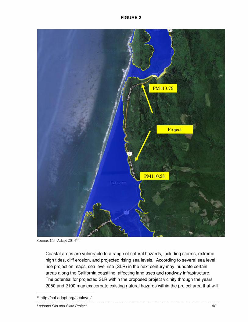
Lagoons Slip and Slide Project 82
Source: Cal-Adapt 201415
Coastal areas are vulnerable to a range of natural hazards, including storms, extreme
high tides, cliff erosion, and projected rising sea levels. According to several sea level
rise projection maps, sea level rise (SLR) in the next century may inundate certain
areas along the California coastline, affecting land uses and roadway infrastructure.
The potential for projected SLR within the proposed project vicinity through the years
2050 and 2100 may exacerbate existing natural hazards within the project area that will
15 http://cal-adapt.org/sealevel/
Project
PM110.58
PM113.76
FIGURE 2

Lagoons Slip and Slide Project 83
need to be addressed on a regional level through collaboration between Caltrans and
local agencies with land use authority.
Of the two locations associated with the project, the project at PM110.58 is located on
the border of the shaded blue and yellow areas shown on the attached sea level rise
map taken from the California Energy Commission’s Cal-Adapt web interface, while the
project located at PM113.76 is located outside of this area. This map shows the areas
of direct impacts due to existing flooding potential or projected sea level rise inundation.
This project proposes to restore failed slopes and improve culvert and drainage design
at the two locations identified. These improvements have an approximated design life of
approximately 20 years. A comprehensive planning and adaptation plan approach will
be required through collaboration efforts between Caltrans and the local land use
planning agencies to ensure future plans for infrastructure and the surrounding land
uses consider sea level rise.
Executive Order S-13-08 also directed the Business, Transportation, and Housing
Agency to prepare a report to assess vulnerability of transportation systems to sea level
rise affecting safety, maintenance and operational improvements of the system, and
economy of the state. Caltrans continues to work on assessing the transportation
system vulnerability to climate change, including the effect of sea level rise.
Currently, Caltrans is working to assess which transportation facilities are at greatest
risk from climate change effects. However, without statewide planning scenarios for
relative sea level rise and other climate change effects, Caltrans has not been able to
determine what change, if any, may be made to its design standards for its
transportation facilities. Once statewide planning scenarios become available, Caltrans
will be able review its current design standards to determine what changes, if any, may
be needed to protect the transportation system from sea level rise.
Climate change adaptation for transportation infrastructure involves long-term planning
and risk management to address vulnerabilities in the transportation system from
increased precipitation and flooding; the increased frequency and intensity of storms
and wildfires; rising temperatures; and rising sea levels. Caltrans is an active
participant in the efforts being conducted in response to EO S-13-08 and is mobilizing
to be able to respond to the National Academy of Science Sea Level Rise Assessment
Report.

Lagoons Slip and Slide Project 84
Section 5 – Comments and Coordination
Early and continuing coordination with the general public and public agencies is an
essential part of the environmental process. It helps planners determine the necessary
scope of environmental documentation and the level of analysis required, and to identify
potential impacts and avoidance, minimization and/or mitigation measures and related
environmental requirements. Agency consultation and public participation for this
project have been accomplished through a variety of formal and informal methods,
including Project Development Team (PDT) meetings and interagency coordination
meetings. This chapter summarizes the results of Caltrans’ efforts to fully identify,
address, and resolve project-related issues through early and continuing coordination.
The Initial Study with Proposed Mitigated Negative Declaration was made available for
public and agency review and comment for 30 days. Caltrans has ensured that the
document was made available to all appropriate parties and agencies, including the
following: 1) Responsible agencies, 2) Trustee agencies that have resources affected
by the project, 3) other state, federal and local agencies which have regulatory
jurisdiction, or that exercise authority over resources which may be affected by the
project, 4) the general public. Copies of the document were made available at the
Caltrans District 3 Office of Environmental Management (M-2) located at 703 B Street,
Marysville, at the District 1 Office at 1656 Union Street, Eureka, at the Eureka Public
Library at 1313 3rd Street, Eureka, and at the Trinidad Public Library at 380 Janis Court,
Trinidad. This document may be downloaded at the following website address:
http://www.dot.ca.gov/dist3/departments/envinternet/envdoc.htm.
Federal Endangered Species Act Consultation Summary
Informal Section 7 Consultation for effects to anadromous fish species under the NMFS
jurisdiction was initiated and a Letter of Concurrence (LOC) was received from NMFS
(NMFS 2015). Consultation for effects to TWG, NSO and MAMU and Designated
Critical Habitat for MAMU and TWG will be covered under the USFWS-Caltrans
Routine Maintenance Programmatic Letter of Concurrence (PLOC) (USFWS 2014).
USFWS’s Programmatic Letter of Concurrence
This project’s activities will be covered under the USFWS-Caltrans Routine
Maintenance Programmatic Letter of Concurrence (PLOC) (USFWS 2014). The PLOC
covers specific maintenance activities (including repair of drainage facilities, and
permanent restoration of storm damage) that “may affect but are not likely to adversely
affect” specific federally listed species including TWG, NSO and MAMU, as well as
other federally listed species that do not occur within the project’s Action Area.

Lagoons Slip and Slide Project 85
The PLOC covers the proposed project's activities and their potential effects to TWG,
NSO, and MAMU (as well as Critical Habitat for TWG and MAMU) with the condition
that the specific Avoidance and Minimization Measures that are outlined in the PLOC
for each applicable species (NSO, MAMU and TWG) can be complied with.
Section 7 Consultation for effects to listed anadramous fish species, designated critical
habitat and consultation for effects to Essential Fish Habitat is in progress. Several
activities associated with this project are not covered under the NMFS’s Programmatic
Authorization for Caltrans Routine Maintenance and Repair Activities. Therefore
informal consultation was required. Caltrans has determined that the project “may
affect but is not likely to adversely affect” the following listed anadromous fish species:
Green sturgeon (Acipenser medirostris), California coastal Chinook salmon
(Oncorhynchus tshawytscha), Northern California steelhead (Oncorhynchus mykiss),
and Coho salmon (Oncorhynchus kisutch). Caltrans received a Letter of Concurrence
(LOC) from NMFS (NMFS, 2015) stating that they are in agreement with these
determinations.
California Endangered Species Act Consultation Summary
Discussions with CDFW for state listed species are in progress. Impacts to state listed
and candidate species will not rise to the level of take under CESA. Section 86 of the
Fish and Wildlife Code defines take as "hunt, pursue, catch, capture, or kill, or attempt
to hunt, pursue, catch, capture, or kill."
Wetlands and Other Waters Coordination Summary
A Jurisdictional Determination Report will be sent to the US Army Corps of Engineers
and the North Coast Regional Water Quality Control Board (RWQCB) for review and
verification. A Coastal Wetland Delineation report will be prepared and submitted to the
California Coastal Commission for their review.
California Coastal Act Coordination
Project Activities must be consistent with the California Coastal Act and the Humboldt
County Local Coastal Program (LCP). Development occurring within areas containing
“Environmentally Sensitive Habitats” (ESHA) shall be subject to conditions and
requirements of the North Coast Area Plan of the Humboldt County LCP.
The California Coastal Act defines ESHA’s as “any area in which plant or animal life or
their habitats are either rare or especially valuable because of their special nature or
role in an ecosystem and which could be easily disturbed or degraded by human
activities and developments” (Coastal Act Section 30107.5). These include:

Lagoons Slip and Slide Project 86
• Areas of special biological significance (RWQCB)
• Rare and Endangered Species habitat
• Coastal wetlands, streams and lagoons
A Coastal Wetland Delineation report, as well as an analysis of ESHAs in the project
area will be submitted to Humboldt County for their review.
The Humboldt County General Plan – North Coast Area Plan also requires that all road
projects employ "suitable techniques and measures necessary to prevent erosion and
minimize surface runoff”. Caltrans will incorporate specific measures (BMP’s) to
prevent erosion.

Lagoons Slip and Slide Project 87
Section 6 – List of Preparers
The following Caltrans staff contributed to the preparation of this Initial Study:
Brady, Marie, Project Engineer. Contribution: Project Design.
Cardiff, Darrell, Associate Environmental Planner (Archaeology). Contribution: Cultural
Resource Report.
Hodgson, Talitha, Project Manager. Contribution: Project Coordination.
Lazzarotto, Laura, Landscape Architect. Contribution: Visual Impact Assessment.
Melendrez, David, Senior Transportation Engineer. Contribution: Water Quality
Assessment Report.
Pepper, Kristine, Hydraulics Engineer. Contribution: Floodplain Evaluation Report.
Pitts, Cassandra, Associate Environmental Planner (Coordinator). Contribution: Initial
Study.
Pommerenck, Adele, Senior Environmental Planner. Contribution: Environmental
Branch Chief.
Thoreson, Katie, Associate Environmental Planner (Natural Science). Contribution:
Project Biologist, Natural Environment Study.
Werner, Steve, Hazardous Waste Specialist. Contribution: Initial Site Assessment.
Zandian, Saeid, Air and Noise Specialist. Contribution: Air and Noise Assessment
Report.

Lagoons Slip and Slide Project 88
Appendix A Public Comments

STATE OF CALIFORN IA·· NATURAL RESOURCES AGENCY
CALIFORNIA COASTAL COMMISSION NORTH COAST DISTRI CT OFFICE
I38 5 EIGHTH STREET • SUlTE 130
ARCATA, CA 9552 1
VO ICE (707) 826-8950
FAC IMILE (707) 826-8960
April27, 2015
California Department of Transportation Attn: Cassandra Pitts Environmental Management M2 Branch 703 B Street Marysvile, CA 95901
EDMUND G. BROWN, JR, Governor
FACS I
RE: Comments on Initial Study with Proposed Mitigated Negative Declaration for "Lagoons Slip and Slide" U.S. Route 101 , Post Mile 110.58/1 13.76, Humboldt County (SCH No. 20 15032089).
Dear Ms. Pitts:
Thank you for the opportunity to comment on the above-referenced environmental document. We received the document at Commission ' s North Coast District Office on March 30, 2015. Please note that the following comments are from Commission staff; the Commission itself has not reviewed the document.
Cal trans proposes to restore and stabilize the southbound Highway 101 around Big Lagoon in Humboldt County, which was damaged by severe storm events in March of2011 that caused two localized slope failures (at PM 110.58 and PM 113.76). At the southern location (PM 110.58, location 1 ), Caltrans proposes to replace the existing 90-ft-long, 18-inch-diameter CSP culvert, which separated due to fill slope failure. Caltrans will excavate the failed slope to prepare for replacement of the damaged down drain and place V-t-ton RSP and imported fill around the downdrain. At the northern location (PM 113.76, location 2), Caltrans proposes to abandon the existing 42-inch-diameter corrugated steel pipe (CSP) culvert that conveys the water of "Truttman Sink," which separated due to embankment slope failure. Caltrans will install a new culvert by drilling sub-horizontally through the roadway fill in a 40-ft by 40-ft jacking pit excavated adjacent to the existing culvert. Dewatering of the site will be necessary, and Caltrans proposes to install a radial array of 11 horizontal drains from a 30-ft by 20-ft drilling pad located within the "Truttman Sink Maintenance Yard" located approximately 100 feet northeast of the proposed "jacking" pit location. After the new culvert is installed, a drain inlet will be placed, which will connect and carry the discharge from both the culvert and horizontal array. The remainder of the culvert to the downdrain, which will be 120 feet long and will remain unburied, will be placed by the cut and fill method. The outlet of the downdrain will terminate into an approximately 23-ft by 10.5-ft rock energy dissipater.
As noted in the environmental document, the proposed project requires a coastal development permit (CDP) from Humboldt County. The County's approval of the CDP would be appealable to

Caltrans Lagoons Slip and Slide Page 2
the Coastal Commission pursuant to Section 30603(a) of the Coastal Act and Section 312-13. 12 of the Humboldt County Coastal Zoning Regulations (CZR) if the project meets any of the following criteria: (1) is located between the sea and the "first public road paralleling the sea" [as defined by CCR Section 13577(i)] ; (2) is located within 300 feet of the inland extent of a beach or of the mean high tide line or within 100 feet of a wetland or estuary; and/or (3) constitutes a major public works project.
The following comments on the proposed project relate to the project's potential impacts on wetlands and other sensitive habitat areas, as discussed below.
1. The analysis of impacts to riparian habitat (Red Alder Forest) at location 2 (pages 19-21) finds that with the incorporation of various mitigation measures, including avo iding the introduction of invasive species, restoring/revegetating temporary impact areas, minimizing the construction footprint, using protective ESA fencing, and hand-removing about an acre of jubata grass from the hillside above Big Lagoon at location 1, there will be a less than significant impact to Red Alder Forest. However, unless an appropriate restorat ion and monitoring plan is developed and implemented for the impact area, it will not be possible to effectively determine whether or not the temporary impact area is restored to pre-construction conditions. We recommend elaborating on the listed avoidance, minimization, and mitigation measures in this section to specify that a Red Alder Forest Restoration Plan will be developed and implemented as proposed. The plan should include identification of a high quality red alder forest reference site that will be used to compare to the proposed restoration site in order to gauge restoration site success. It also should describe the specific success criteria that will be used throughout the duration of the monitoring period, such as native species cover and diversity in each vegetative stratum. Since it is a forest habitat that is being restored, monitoring of the site should occur for a long enough period for success to be realized, at least five years . The monitoring report should include a contingency/remediation plan in case success criteria are not met by the end of the monitoring period. With inclusion of this addition ofthis plan requirement mitigation measure, the project would minimize the project's substantial adverse effects on the red alder forest riparian habitat.
2. The project will impact a small area of Arroyo Willow thicket at location 1, but the document finds this impact to be less than significant because invasive species will be controlled/removed, native species will be planted in disturbed areas, the construction footprint will be minimized, ESA fencing w ill be used to protect adjacent sensitive habitats, and an acre of jubata grass will be removed from the hills lope and replaced with native species. Similar to the above comments for Red Alder Forest, we recommend adding a mitigation measure that would require the development and implementation of a monitoring plan for the willow habitat to ensure the success of its expected regrowth. The plan should include remedial measures to be undertaken if specified success criteria are not met within the monitoring timeframe. With inclusion of this additional mitigation measure to ensure no net loss of Arroyo Willow habitat, the project would minimize any substantial adverse effect on riparian habitat.
3. The environmental document describes impacts to about 0.02-acre of Wet Meadow habitat due to the proposed construction of the cut and cover portion of the culvet1 installation. It's unclear if this calculation includes impacts to coastal wetlands or only to wetlands defined by Section 404 of the Clean Water Act. Because the County ' s LCP includes policies requiring appropriate mitigation for wetland impacts (e.g. , Section 30233 of the Coastal Act is codified in Section 3.40 of the North Coast Area Plan), the document should accurately quantify and
Caltrans Lagoons Slip and Slide Page 3
propose feasible mitigation for the full extent of the project's coastal wetland impacts, which may be greater than the calculated impacts to federally protected wetlands.
4. Similar to comments in #1 and #2 above, the document should add a mitigation measure that would require the development and implementation of a monitoring plan for the 0.13-acre of affected freshwater marsh habitat at location 2 to ensure its successful restoration. The plan should include remedial measures to be undertaken if specified success criteria are not met within the monitoring timeframe. In addition, the plan should include mitigation for the project's permanent impacts to 30-square-feet of freshwater marsh. At least 30 square feet of freshwater marsh wetland should be created or restored to avoid any net loss of freshwater marsh habitat. Due to temporal loss and uncertainty of restoration success, the mitigation ratio should be greater than 1:1 (e.g. , at least 2:1 to 4:1 restored wetland to impacted wetland). With inclusion of these additiona' mitigation measures, the project would minimize any substantial adverse effects on freshwater marsh habitat.
5. According to Table 3 of the document, the project will temporarily impact about 0.70-acre of coastal wetlands and permanently impact ~3,621 square feet of coastal wetlands. Additional temporary and permanent impacts would occur to other waters per Table 4 (1 03 linear feet of temporary impacts and 843 feet of permanent impacts). The document concludes that with the incorporation of certain avoidance and minimization measures (specified as implementing basic construction-related BMPs, dewatering areas prior to construction, leaving the downdrain at location 2 unburied, and revegetating disturbed areas), there would be a less than significant impact to wetlands and other waters. In terms of compensatory mitigation for the calculated impacts, the document states that proposed onsite mitigation includes enhancement of 0.25-acre of the disturbed wet meadow area at location 2. The document goes on to state that "Additional offsite mitigation may be required for this project; however, the location of any proposed offsite mitigat~on has yet to be determined ... "
We disagree with the document conclusion that there would be a less than significant impact to wetlands and other waters simply by including the few mitigation measures proposed. We believe that the document should identify a feasible mitigation site to compensate for all the project's wetland impacts to avoid any significant adverse effects that the project may have on coastal wetlands and waters. Section 30233 of the Coastal Act, codified in Section 3.40 of the Humboldt County North Coast Area Plan, requires that projects involving diking, dredging, and filling of coastal wetlands and waters shall represent the least environmentally damaging feasible alternative and shall include feasible mitigation measures to minimize adverse environmental effects. We therefore recommend that for each element of the project involving diking, dredging, and/or filling of coastal wetlands and waters (including both temporary and permanent impacts), Cal trans should undertake an analysis of project element alternatives to ensure that the proposed project, in its entirety, represents the least environmentally damaging feasible alternative with respect to proposed design, equipment staging and stockpiling areas, etc. The project also should include a wetland mitigation plan to minimize the project's effects on coastal wetlands and waters and to compensate for the projected loss of wetlands/waters habitat. If the wetland mitigation cannot be accommodated on site, then Caltrans should identify a feas ible off-site location(s) to perform in-kind wetland mitigation. The wetland mitigation ratio (type and amount of wetlands restored to type and amount of wetlands impacted) should be great enough to account both for the temporal loss of wetland habitat and function (from the time of impact to the time that the mitigation

Caltrans Lagoons Slip and Slide Page 4
wetland has been successfully restored to a functional habitat) and for the inherent uncertainty of mitigation success
1•
Again, thank you for the opportunity to comment, and feel free to contact me with any questions.
Sincere~~ bJcJ~ Melissa B. Kraemer Supervising Planner
Cc: State Clearinghouse, P.O. Box 3044, Sacramento, CA 95812-3044 Steve Werner, Humboldt County Planning and Building Department
Ec: Tami Grove, Statewide Development & Transportation Program Manager, [email protected]
1 E.g., see Ambrose et al. 2007. http://www.waterboards.ca.gov/water issues/programs/cwa40 1 /docs/mitigation final report full081307 .pdf

Response to Comments from the California Coastal Commission
Response to Comment #1: The jubata grass will be removed both by hand and also by heavy
equipment as described in the Description of the Project (Section 1) of the Final Environmental
Document.
Response to Comment #2: A Restoration/Revegetation Plan will be developed for all areas
that will be disturbed by the project. This plan will include a five-year monitoring/plant
establishment period with specific success criteria, including criteria for native species cover
and diversity in each stratum. Success criteria will be developed using the existing Red Alder
forest within the project area as a reference site and/or another area of high quality red alder
forest nearby. The plan will include a contingency/remediation plan in case success criteria are
not met by the end of the monitoring period. This plan will be submitted to the California Coastal
Commission and other agencies for review.
Response to Comment #3: Information on this restoration/revegetation plan will be included in
the listed avoidance, minimization, and mitigation measures section of the Final Environmental
Document.
Response to Comment #4: The project is expected to result in only minor, temporary impacts
to Arroyo Willow Thicket. Impacts to this community are expected as a result of disturbance
resulting from the removal and replacement of the downdrain; specifically, trimming for access
and crushing and/or breaking of branches could occur during the replacement. The document
found these impacts to be less than significant without mitigation; however, avoidance,
minimization and mitigation measures were proposed to further minimize potential impacts in
order to fulfill stewardship responsibilities and comply with Federal Highway Administration
(FHWA) mitigation policy. Under this policy, mitigation of impacts must be considered whether
or not the impacts are significant and agencies are required to identify and include in the action
all relevant and reasonable mitigation measures that could improve the action.
Response to Comment #5: A Restoration/Revegetation Plan will be developed for all areas
that will be temporarily disturbed by the project. This plan will include a five-year
monitoring/plant establishment period with specific success criteria, including criteria for native
species cover and diversity in each stratum. The plan will include a contingency/remediation
provision in case success criteria are not met by the end of the monitoring period. This plan will
be submitted to the California Coastal Commission and other agencies for review prior to
construction.
Response to Comment #6: We will include information on the restoration/revegetation plan in
the listed avoidance, minimization, and mitigation measures in this section in the Final
Environmental Document.

Response to Comment #7: The wet meadow was delineated as a USACE wetland. Therefore,
this 0.02 acres of impact to wet meadow includes both coastal wetland and 404 jurisdictional
wetland impacts. Since the project is in the coastal zone, all wetlands (including CWA Section
404/USACE jurisdictional wetlands) within the project area are considered coastal wetland. In
addition, there were several features that were identified as coastal wetland only. A total of
approximately 0.69 acre of temporary impacts and 0.09 permanent impacts to coastal wetlands
are expected to result from the construction of this project. These impacts will be fully mitigated
(See Response to Comment #’s 10, 11 & 13 below). Changes will be made to the final
environmental document to clarify the extent of coastal wetland impacts.
Response to Comment #8: A Restoration/Revegetation Plan will be developed for all areas
that will be temporarily disturbed by the project. This plan will include a five-year
monitoring/plant establishment period with specific success criteria, including criteria for native
species cover and diversity in each stratum. The plan will include a contingency/remediation
provision in case success criteria are not met by the end of the monitoring period. This plan will
be submitted to the California Coastal Commission and other agencies for review prior to
construction.
Information on the restoration/revegetation plan will be included in the listed avoidance,
minimization, and mitigation measures in this section in the Final Environmental Document.
Response to Comment #9: In addition to restoration of all temporarily impacted areas,
permanent impacts to freshwater marsh will be fully mitigated offsite at an approximate 80-acre
Caltrans mitigation site (located in the Arcata bottoms, near the Mad River Slough Wildlife Area)
that will be restored to palustrine forested, palustrine scrub-shrub wetland mosaic and include
seasonally flooded marsh.
Response to Comment #10: Permanent impacts to wetlands will be mitigated at a 4.2:1
(onsite) and 5.1:1 (offsite) ratio (restored wetland to impacted wetland). Permanent impacts to
freshwater marsh for this project will be mitigated offsite and therefore, at a 5.1:1 ratio.
Response to Comment #11: A Mitigation and Monitoring Plan will be developed for
compensatory wetland mitigation associated with the project, including the restoration of the
approximately 0.24 acre disturbed wet meadow (onsite) as well as restoration of freshwater
marsh and palustrine forested wetland offsite at a Caltrans owned mitigation parcel. This Plan
will be submitted to appropriate agencies prior to construction (during the permitting phase of
the project). Caltrans proposes offsite mitigation, additional to on-site restoration, as part of a
larger Caltrans’ Humboldt Bay area mitigation effort; a US Army Corps of Engineers and
Coastal Commission approved 80-acre mitigation area that is planned to be developed in 2018.

Response to Comment #12:
Measures to minimize temporary and permanent impacts to coastal wetlands and waters were
incorporated into the project design and include limiting work to the roadway and existing
disturbed area as much as possible. The horizontal drain pit and drainage array placement were
designed to minimize impacts to existing wetland areas, as a radial pattern was chosen instead
of the traditional horizontal pattern which would result in more wetland impacts.
Response to Comment #13: Caltrans proposes the following ratios to mitigate for the loss of
wetlands: 5.1:1(offsite) and 4.2:1 (onsite) ratio for permanent impacts to wetlands and a 1:1
ratio for temporary impacts to wetlands; these ratios were developed using USACE guidance
(See attached SPD Mitigation Ratio Setting Checklist [12501.1]).