lake chelan - amazon s3 · 2017-12-04 · lake chelan grp october 2015 chapter 1 13 chapter 1...
TRANSCRIPT
NNoorrtthhwweesstt AArreeaa CCoommmmiitttteeee OCTOBER 2015
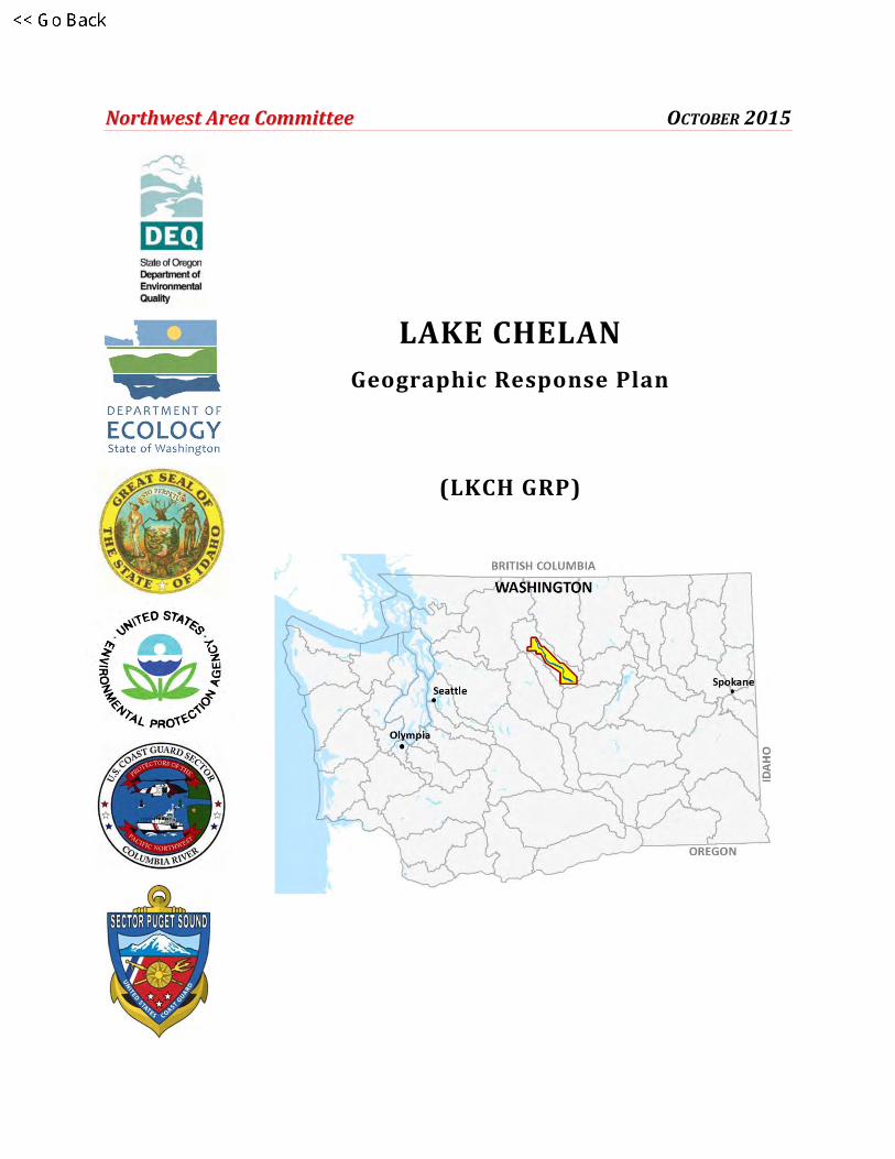
LAKE CHELAN
Geographic Response Plan
(LKCH GRP)

2
This page was intentionally left blank.

LAKE CHELAN GRP OCTOBER 2015
3
LAKE CHELAN
Geographic Response Plan
(LKCH GRP)
LAKE CHELAN GRP OCTOBER 2015
4
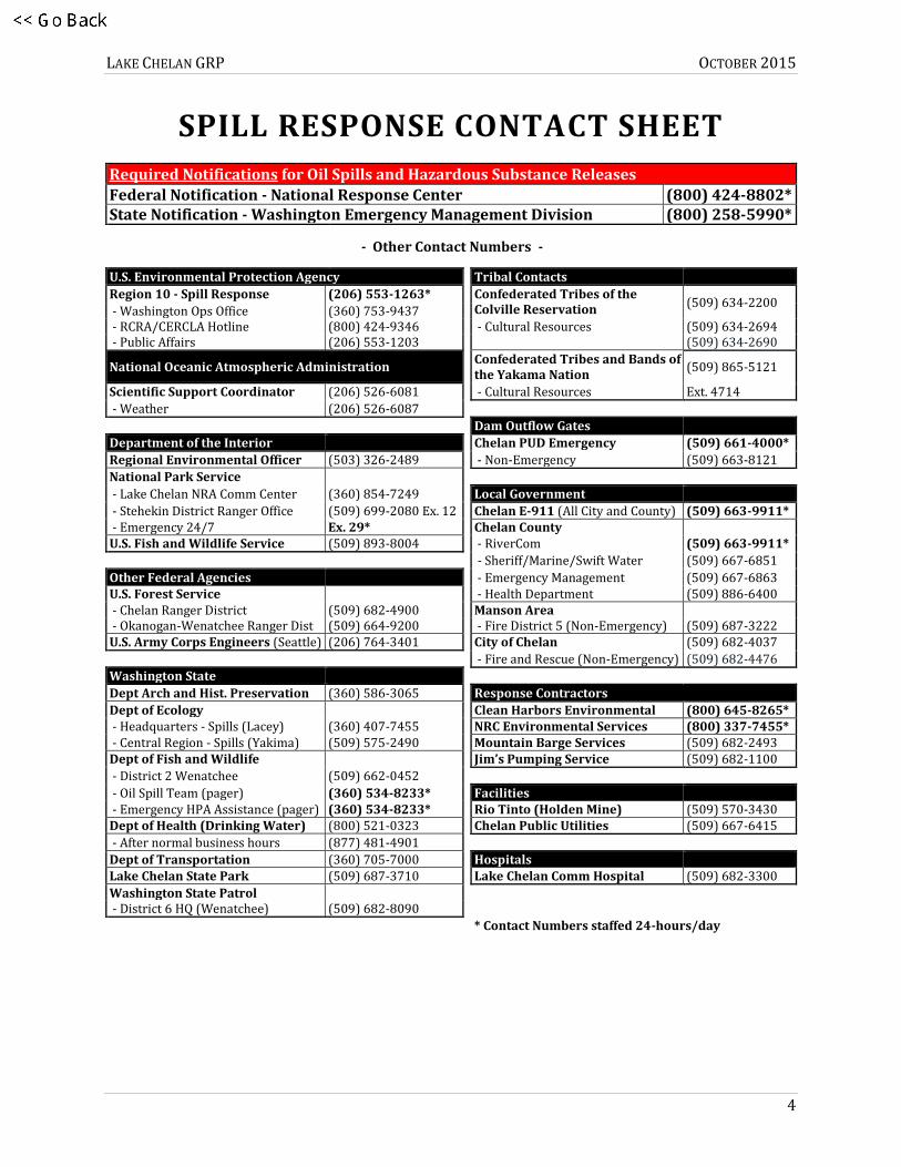
SPILL RESPONSE CONTACT SHEET
Required Notifications for Oil Spills and Hazardous Substance Releases
Federal Notification - National Response Center (800) 424-8802* State Notification - Washington Emergency Management Division (800) 258-5990*
- Other Contact Numbers -
U.S. Environmental Protection Agency
Tribal Contacts
Region 10 - Spill Response (206) 553-1263*
Confederated Tribes of the Colville Reservation
(509) 634-2200 - Washington Ops Office (360) 753-9437
- RCRA/CERCLA Hotline (800) 424-9346
- Cultural Resources (509) 634-2694
- Public Affairs (206) 553-1203
(509) 634-2690
Confederated Tribes and Bands of the Yakama Nation
(509) 865-5121 National Oceanic Atmospheric Administration
Scientific Support Coordinator (206) 526-6081
- Cultural Resources Ext. 4714
- Weather (206) 526-6087
Dam Outflow Gates
Department of the Interior
Chelan PUD Emergency (509) 661-4000*
Regional Environmental Officer (503) 326-2489
- Non-Emergency (509) 663-8121
National Park Service
- Lake Chelan NRA Comm Center (360) 854-7249
Local Government
- Stehekin District Ranger Office (509) 699-2080 Ex. 12
Chelan E-911 (All City and County) (509) 663-9911* - Emergency 24/7 Ex. 29*
Chelan County
U.S. Fish and Wildlife Service (509) 893-8004
- RiverCom (509) 663-9911*
- Sheriff/Marine/Swift Water (509) 667-6851
Other Federal Agencies
- Emergency Management (509) 667-6863 U.S. Forest Service
- Health Department (509) 886-6400
- Chelan Ranger District (509) 682-4900
Manson Area - Okanogan-Wenatchee Ranger Dist (509) 664-9200
- Fire District 5 (Non-Emergency) (509) 687-3222
U.S. Army Corps Engineers (Seattle) (206) 764-3401
City of Chelan (509) 682-4037
- Fire and Rescue (Non-Emergency) (509) 682-4476
Washington State
Dept Arch and Hist. Preservation (360) 586-3065
Response Contractors
Dept of Ecology
Clean Harbors Environmental (800) 645-8265* - Headquarters - Spills (Lacey) (360) 407-7455
NRC Environmental Services (800) 337-7455*
- Central Region - Spills (Yakima) (509) 575-2490
Mountain Barge Services (509) 682-2493 Dept of Fish and Wildlife
Jim’s Pumping Service (509) 682-1100
- District 2 Wenatchee (509) 662-0452
- Oil Spill Team (pager) (360) 534-8233*
Facilities - Emergency HPA Assistance (pager) (360) 534-8233*
Rio Tinto (Holden Mine) (509) 570-3430
Dept of Health (Drinking Water) (800) 521-0323
Chelan Public Utilities (509) 667-6415
- After normal business hours (877) 481-4901
Dept of Transportation (360) 705-7000
Hospitals Lake Chelan State Park (509) 687-3710
Lake Chelan Comm Hospital (509) 682-3300
Washington State Patrol
- District 6 HQ (Wenatchee) (509) 682-8090
* Contact Numbers staffed 24-hours/day
LAKE CHELAN GRP OCTOBER 2015
5
Before you print this document
Chapter 4 with appendices (Adobe pages 25-116) of this document are provided in “landscape”
page orientation; all other chapters and appendices are oriented in “portrait.” The appendices in
Chapter 4 (Adobe pages 63-116) have been designed for duplex printing (front and back side of
paper), “open to top” configuration.

LAKE CHELAN GRP OCTOBER 2015
6
Purpose and Use of this Plan
This Geographic Response Plan (GRP) constitutes the federal and state on-scene coordinators’
orders during the initial phase of an oil spill: from the time a spill occurs until a Unified Command is
established. Its main focus is sensitive resource protection. The plan prioritizes tactical response
strategies based on locations where spills might occur and the proximity of those locations to
natural, cultural, and economic resources at risk of injury. By using this document it’s hoped that
immediate and proper action can be taken to reduce spilled oil’s impact on sensitive resources
within the planning area.
After a spill occurs, control and containment at or near the spill source are top priorities. Beyond
those efforts, the tactical response strategies provided in this plan should be implemented using the
priority tables in Chapter 4, unless overflight observations, spill trajectory models, or unique
circumstances dictate otherwise.

LAKE CHELAN GRP OCTOBER 2015
7
RECORD OF CHANGES
Date Change Number Summary of Changes
Name of Person Making Change
May 2015 Original Release
October 2015 LKCH 001 Update of Purpose and Use, Chapter 1, and Chapter 4. Removal of Protection Techniques and GRP Contributors from Appendices. Moved Appendix C to 1A.
Wendy Buffett

LAKE CHELAN GRP OCTOBER 2015
8
This page was intentionally left blank.

LAKE CHELAN GRP OCTOBER 2015
9
TABLE OF CONTENTS CHAPTER 1 – Introduction ............................................................................................................................................... 13
1.1 GRP Chapters and Appendices ......................................................................................................................... 14
1.2 Geographic Response Plan Development Process ................................................................................... 14
1.3 Standardized Response Language .................................................................................................................. 15
1.4 Terminology and Definitions ............................................................................................................................ 15
APPENDIX 1A – Comments, Corrections or Suggestions ................................................................................. 17
CHAPTER 2 – Site Description.......................................................................................................................................... 19
2.1 Introduction ............................................................................................................................................................. 19
2.2 Physical Features ................................................................................................................................................... 19
2.3 Hydrology ................................................................................................................................................................. 20
2.4 Climate and Winds ................................................................................................................................................ 20
2.5 Tides and Currents ................................................................................................................................................ 21
2.6 Risk Assessment ..................................................................................................................................................... 21
2.7 References ................................................................................................................................................................ 22
CHAPTER 3 – (Reserved) .................................................................................................................................................. 23
CHAPTER 4 – Response Strategies and Priorities ................................................................................................... 25
4.1 Chapter Introduction ............................................................................................................................................ 26
4.1.1 On-site Considerations ........................................................................................................................... 26
4.1.2 Historical River Streamflow Ranges: ................................................................................................ 30
4.2 Area Maps ................................................................................................................................................................. 32
4.3 Strategy and Response Priorities .................................................................................................................... 37
4.3.1 General Response Priorities ................................................................................................................. 37
4.3.2 Strategy Priorities based on Potential Spill Origin Points ....................................................... 37
4.4 Sector Maps (Strategy Locations) ................................................................................................................... 43
4.5 Matrices ..................................................................................................................................................................... 53
4.5.1 Strategy Names .......................................................................................................................................... 53
4.5.2 Response Strategy Matrices ................................................................................................................. 54

LAKE CHELAN GRP OCTOBER 2015
10
4.5.3 Notification Strategy Matrices ............................................................................................................. 59
4.5.4 Staging Area Matrices ............................................................................................................................. 60
4.5.5 Boat Launch Location Matrices........................................................................................................... 61
APPENDIX 4A – Response Strategy 2-Pagers ...................................................................................................... 63
APPENDIX 4B – Notification Strategy 2-Pagers .................................................................................................. 91
APPENDIX 4C – Staging Area 2-Pagers ................................................................................................................ 101
APPENDIX 4D – Boat Launch 2-Pagers ................................................................................................................ 109
CHAPTER 5 – (Reserved) ............................................................................................................................................... 117
CHAPTER 6 – (Reserved) ............................................................................................................................................... 119

LAKE CHELAN GRP OCTOBER 2015
11
LIST OF FIGURES
Figure 4-1: Historic streamflow for significant rivers near Lake Chelan ...................................................... 31

LAKE CHELAN GRP OCTOBER 2015
12
LIST OF TABLES
Table 2-1: Lake Specific Information ........................................................................................................................... 20
Table 4-1: Water Speed Drift Measurement Table ................................................................................................. 29
Table 4-2: Historic streamflow for significant rivers near Lake Chelan ........................................................ 30
Table 4-3: Priority Table LKCH-A (Barge Loading Dock in Chelan) ................................................................ 39
Table 4-4: Priority Table LKCH-B (Manson) ............................................................................................................. 40
Table 4-5: Priority Table LKCH-C (Dutch Harbor) ................................................................................................. 41
Table 4-6: Priority Table LKCH-D (Lucerne Landing) ........................................................................................... 42

LAKE CHELAN GRP OCTOBER 2015
CHAPTER 1 13
CHAPTER 1
Introduction
This plan focuses on sensitive resource protection after an oil spill occurs. It serves as the federal
and state on-scene-coordinators’ orders during the initial phase of an oil spill response in the Lake
Chelan area. It has been approved by Regional Response Team 10 and the Chairs and Co-Chairs of
the Northwest Area Committee. Changes to this document are expected as more testing is
conducted through drills, site visits, and actual use in spill situations. We value your input and hope
that you’ll let us know how the plan might be improved. Please submit comments online at
http://www.rrt10nwac.com/Comment. Comments may also be emailed to [email protected] or
submitted by mail using the forms and information provided in Appendix 1A of this document.
This is a condensed GRP developed for Lake Chelan partially in response to the Holden Mine
Superfund remediation project. This GRP is located in Central Washington, north of Wenatchee in
the rain shadow of the Cascade Range. The area included in this plan is Lake Chelan from the city of
Chelan to Lucerne Landing.
The bulk of this plan is contained in Chapter 4. It provides information on tactical response
strategies and the order they should be implemented, based on potential spill origin points and
their proximity to sensitive resources. Area and sector maps and information on staging areas and
boat launch locations are also provided in that chapter.
Control and Containment of an Oil Spill are a Higher Priority
than the Implementation of GRP Response Strategies
If in the responder’s best judgment, control and containment of an oil spill at or near the source of a
spill isn’t feasible, or if the source is controlled and contained but oil has spread out beyond initial
containment, then the priorities laid out in Section 4.3 of this plan should take precedence until a
Unified Command is formed. It’s important to note that spill response priorities, beyond those
described in this plan, should rely on aerial observations and spill trajectory modeling. A booming
strategy listed as a high priority in Section 4.3 would not necessarily be implemented if a spill
trajectory didn’t warrant action in that area; however, the priority tables should be followed until
spill trajectory information becomes available. During an incident, modifications to the deployment
priorities provided in Section 4.3 of this plan may be made if approved by the Incident Commander
or Unified Command.
The movement of oil and the time it takes to mobilize response resources to deploy GRP strategies
must always be considered when setting strategy implementation priorities. The strategies

LAKE CHELAN GRP OCTOBER 2015
CHAPTER 1 14
discussed in this plan have been designed for use with persistent oils that float on water and may
not be suitable for other petroleum products or hazardous substances. For hazardous substance
spills, refer to the Northwest Area Contingency Plan (NWACP), Chapter 7000.
1.1 GRP CHAPTERS AND APPENDICES
CHAPTER 1 Introduction
APPENDIX 1A GRP Comment Form
CHAPTER 2 Site Description
CHAPTER 3 Reserved
CHAPTER 4 Response Strategies and Priorities
APPENDIX 4A Response Strategies
APPENDIX 4B Notification Strategies
APPENDIX 4C Staging Area Locations
APPENDIX 4D Boat Launch Locations
CHAPTER 5 Reserved
CHAPTER 6 Reserved
1.2 GEOGRAPHIC RESPONSE PLAN DEVELOPMENT PROCESS
GRPs are considered part of the NWACP, although revised and distributed separately. They’ve been
developed for the marine and inland waters of Washington, Oregon, and Idaho. The plans are
prepared through the efforts of, and in cooperation with, Washington Department of Ecology,
Oregon Department of Environmental Quality, Idaho State Emergency Response Commission, U.S.
Coast Guard, U.S. Environmental Protection Agency, as well as other state and federal agencies,
tribal and local governments, response organizations, emergency responders, and communities.
GRPs are developed through workshops and meetings with representatives of these organizations
as well as local oil spill emergency response experts, industry, environmental and conservation
organizations, ports, and pilots, among others. Participants identify resources that may be at risk of
injury from spills and attempt to develop oil spill response or notification strategies to reduce the
chance of injury to those resources.
After compiling information on sensitive resources in the area, site visits are conducted to gather
data and determine if spill response strategies near those resources should be added, modified, or
deleted. In this, the anticipated effectiveness of existing strategies are reviewed, modifications
made as determine necessary, potentially unsafe or ineffective strategies removed, and new
strategies added to the plan. Unfortunately, the dynamics of marine and inland water environments
and the present limitations of response technology make the development of strategies for all
resource locations impracticable. A draft plan is produced after site visits are completed, and made
available for public review and comment before a final version of the GRP is produced and
published. A responsiveness summary is also published that addresses public comments received
during the GRP update process.

LAKE CHELAN GRP OCTOBER 2015
CHAPTER 1 15
1.3 STANDARDIZED RESPONSE LANGUAGE
In order to avoid confusion in response terminology, this plan uses standard National Interagency
Incident Management System, Incident Command System (NIIMS ICS) terminology.
1.4 TERMINOLOGY AND DEFINITIONS
The glossary provided in Section 1910 of the NWACP and other sections of the area plan with
glossaries independent of Section 1910 should be used when seeking the meaning of terms used in
this plan.

LAKE CHELAN GRP OCTOBER 2015
CHAPTER 1 16
This page was intentionally left blank.

LAKE CHELAN GRP OCTOBER 2015
APPENDIX 1A 17
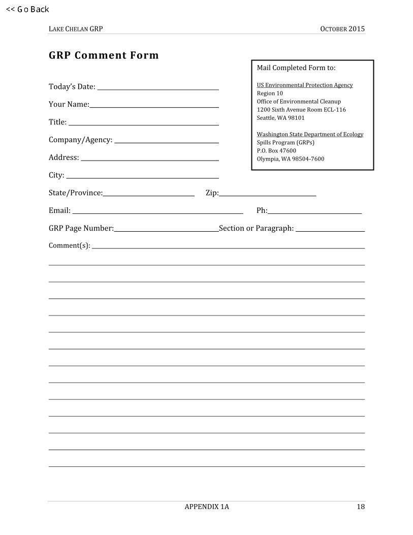
APPENDIX 1A
Comments, Corrections, or Suggestions
We value your input and hope that you’ll submit comments on how this plan might be improved. If
you have any questions or comments, suggestions for improvement, or find errors in this document
please submit comments online at http://www.rrt10nwac.com/Comment, email them to us at
[email protected], or forward them via U.S. Mail to the following agencies:
United States Environmental Protection Agency
Region 10
Office of Environmental Cleanup
1200 Sixth Avenue
Room ECL-116
Seattle, WA 98101
Washington State Department of Ecology
Spill Prevention, Preparedness, and Response (GRPs)
P.O. Box 47600
Olympia, WA 98504-7600
The form on the following page of this attachment can be used to submit comments by mail. Contact
information is requested so that we can give you a call if more information or comment clarification
is needed.
Please use the GRP Field Report Form for providing information on GRP strategy field visits or the
testing of response strategies. The form is available online at http://www.ecy.wa.gov/programs/
spills/preparedness/GRP/Form-GRPFieldReport.pdf. Additional information on Geographic
Response Plans is available at http://www.rrt10nwac.com/GRP.
LAKE CHELAN GRP OCTOBER 2015
APPENDIX 1A 18
GRP Comment Form
Today’s Date:
Your Name:
Title:
Company/Agency:
Address:
City:
State/Province: Zip:
Email: Ph:
GRP Page Number: Section or Paragraph:
Comment(s):
Mail Completed Form to:
US Environmental Protection Agency Region 10
Office of Environmental Cleanup
1200 Sixth Avenue Room ECL-116
Seattle, WA 98101
Washington State Department of Ecology
Spills Program (GRPs)
P.O. Box 47600
Olympia, WA 98504-7600
LAKE CHELAN GRP OCTOBER 2015
CHAPTER 2 19
CHAPTER 2
Site Description
2.1 INTRODUCTION
This chapter provides a description of the area’s geography, hydrology, and climate, and includes an
overview of oil spill risks in the Lake Chelan area. The condensed plan covers Lake Chelan between
Lucerne Landing and the City of Chelan, plus a notification strategy in Stehekin.
2.2 PHYSICAL FEATURES
Lake Chelan is both the deepest and largest natural lake in the state, and the third deepest lake in
the country. Over fifty miles long but averaging just one mile wide, it cuts northwest to southeast at
a roughly forty-five degree angle. At the northwestern top of the lake is the Stehekin River, which
provides almost 70 percent of the annual water to the lake. The rest of the inflow is provided by
creeks and streams draining the surrounding Cascade Range and Chelan Mountains.
The majority of the land surrounding the lake is federally-owned natural area. The Lake Chelan
National Recreation Area covers the northern watershed and the northern five miles of the lake,
down to the border of the Okanogan-Wenatchee National Forest. Within the Forest include the sub-
areas of the Lake Chelan Sawtooth Wilderness on the east and the Glacier Peak Wilderness to the
west. The Chelan Ranger District controls the central portion of the lake. The southern seven miles
of the lake contain the vast majority of the residents and developed areas.
The largest population center is the city of Chelan, population 4000, which wraps around the
southeastern point of the lake. There, the lake drains to the Chelan River, passing through town to
the Lake Chelan Dam before emptying into the Columbia River. The only other developed areas
along the lake are an unincorporated suburb of Chelan called Manson, population 1500, and the
community of Stehekin at the northeastern tip of the lake. Stehekin is only accessible by ferry (The
Lady of the Lake), boat, seaplane, or by foot over Cascade Pass. While Stehekin Airport is open July,
August and September, it is considered a difficult landing spot, and is sometimes commandeered for
wildland fire response. Due to the transport limitations to the central and northern portions of the
lake, it is unlikely that the year-round population there will significantly increase in the future.
Nevertheless, Stehekin is a popular spot for tourists and private boaters during the summer. The
Lake Chelan National Recreation Area sees between 35,000 and 45,000 annual visitors.
Lucerne Landing is a ferry stop located about seven miles south of Stehekin, on the west shore of
the lake. Eleven miles west of the landing is Holden Village, a Lutheran retreat center that hosts
5,000 visitors annually and houses 60 to 100 year-round residents. Next to Holden Village is the
decommissioned Holden Mine, which produced copper, zinc, gold and silver between 1930 and
1957 before closing abruptly. It is currently undergoing remediation as a Superfund site. Visitors

LAKE CHELAN GRP OCTOBER 2015
CHAPTER 2 20
and supplies can only arrive via boat or seaplane to the dock at Lucerne Landing, and are then
driven on a gravel forest road that parallels Railroad Creek up to Holden Village and the mine.
Table 2-1: Lake Specific Information
Physical Features English Units Metric Units
Max. length 50.5 mi 81.3 km
Surface area 52.1 mi2 / 21,600 acres 135 km2
Average depth 474 ft 144 m
Max. depth 1486 ft 453 m
Water volume 15,800,000 acre ft 3.0 km3
Surface elevation 1098 ft 335 m
Islands None
2.3 HYDROLOGY
Officially known as the Chelan Hydroelectric Project, the Chelan Dam was built in 1928 and is
located less than a mile from the river’s mouth. It is a steel-reinforced concrete gravity dam, 40 feet
high and 490 feet long. Chelan County Public Utility District Number 1 controls the dam outflows
and maintains the water level in the lake.
The flow into the lake from the Stehekin River, Railroad Creek and other tributaries is largely
determined by snowmelt, rather than direct runoff from rainfall. The water level in the lake is
lowest in early spring, before the snow has melted. Snowmelt in April and May leads to peak water
levels from June through September, remaining steady around 1098 feet. The Chelan County Public
Utility District’s license encourages the lake level to stay between 1100 feet and 1079 feet elevation,
but maintaining ideal flow to the Chelan River takes precedence. The output through the Chelan
Dam is generally steady throughout the year.
2.4 CLIMATE AND WINDS
Lake Chelan’s climate is similar to the rest of eastern Washington, with near-desert levels of
precipitation. The annual average precipitation at Lake Chelan is 11.4 inches. Rainfall is fairly
evenly distributed throughout the year, but in mid-summer it is not unusual for a month or six
weeks to pass without any measurable rainfall. The wettest month is November, with an average
rainfall of 1.77 inches. Summer high temperatures tend to be in the 80's and winter lows tend to be
in the 30's.
Winds on Lake Chelan are strong from April through July, particularly in the upper part of the lake
between Stehekin and Lucerne. Sustained winds over 20 miles per hour (mph) are common, with
gusts near 40 mph. Stronger winds are unusual but gusts of over 80 mph have occurred.

LAKE CHELAN GRP OCTOBER 2015
CHAPTER 2 21
Wind direction is usually “down lake” (from NW to SE) in late spring to early summer, but direction
and speed can vary significantly throughout the day. The rest of the year winds are calmer and
more varied in direction. Winds are lower in the lower section of the lake, near Manson and Chelan,
but follow the same seasonal pattern.
2.5 TIDES AND CURRENTS
Lake Chelan has no discernible tides or currents. The flow from the tributaries to the Chelan River
is generally north-to-south, but the rate at which the lake empties is so low that it should have no
major impact on the movement of oil. Wind direction and speed will be the most significant factor
in the direction of travel.
2.6 RISK ASSESSMENT
This condensed plan is written to address the oil spill risk presented by a barge transporting fuel to
the Holden Mine Superfund Site, along with above-ground diesel storage tanks at the site. At a
future date this plan will be expanded to include other areas of Lake Chelan. Rio Tinto mining is
responsible for the cleanup project and their Spill Prevention, Control, and Countermeasure plan
has been approved by several state and federal agencies.
A 120 foot unmanned barge and 25 foot tug depart the Chelan Staging Area and dock at Lucerne
Landing, where a fuel truck carrying up to 4,600 gallons of diesel drives off the barge and follows
the gravel-topped Forest Service Road 8031 for 11 miles along Railroad Creek. The largest fuel
storage tank at the cleanup site holds 10,000 gallons of diesel, with another two 5,000-gallon tanks
nearby. Vehicles and construction equipment hold under 100 gallons of diesel each. Mountain
Barge Services , who operate the tug, are also spill responders who maintain equipment at their
headquarters in Chelan. There is a trailer of spill response equipment that can be transported on
the barge, or stationed in Chelan or Lucerne.
Barges also deliver gasoline and diesel to the residents of Stehekin. This is the most significant spill
risk in the northern part of the lake past Lucerne Landing, and will continue to be a risk after the
Holden Mine project is completed. Recreational boating is also popular in this area during the
summer, and smaller spills from these watercraft are possible.
Other areas at risk from significant spills are in the city of Chelan and its suburbs. The bridges at
West Woodin Avenue and Webster Avenue/Highway 97 span the Chelan River, where road based
spills would flow south towards the dam. Highway 97, Highway 150 and Highway 971/Lakeshore
Road all parallel the southeastern five to ten miles of lakeshore and pose a potential threat from
tanker truck accidents.
Shoreside businesses, personal boats, ferries and seaplanes are the other oil spill risks in the area.
There are no pipelines, railroads or oil terminals in the watershed.

LAKE CHELAN GRP OCTOBER 2015
CHAPTER 2 22
2.7 REFERENCES
Chelan County Public Utility District. (2015). Lake Chelan hydro project. Retrieved from
http://www.chelanpud.org/lake-chelan-hydro-project.html
Holden Village. (2015). Holden village website. Retrieved from http://www.holdenvillage.org/
Lake Chelan Chamber of Commerce. (2015). Lake Chelan webpage. Retrieved from
http://www.lakechelan.com
Pool Engineering, Inc. Engineers and Constructors. (2011). Revised hazardous materials control plan
for Holden Mine remediation project. Chelan, WA.
Rector, J., and Hallock, D. Washington State Department of Ecology, Environmental Investigations
and Laboratory Services Program Ambient Monitoring Section. (1993). Lake water quality
assessment project 1990. (92-124). Retrieved from website:
https://fortress.wa.gov/ecy/publications/summarypages/92124.html
Washington State Department of Transportation. (2015). Stehekin State Airport. Retrieved from
http://www.wsdot.wa.gov/aviation/AllStateAirports/Stehekin_StehekinState.htm
USDA Forest Service. Okanogan-Wenatchee National Forest Map [Web Map]. Retrieved from
http://www.fs.usda.gov/Internet/FSE_DOCUMENTS/stelprdb5311776.pdf

LAKE CHELAN GRP OCTOBER 2015
CHAPTER 3 23
CHAPTER 3
(Reserved)

LAKE CHELAN GRP OCTOBER 2015
CHAPTER 3 24
This page was intentionally left blank.

LAKE CHELAN GRP OCTOBER 2015
CHAPTER 4 25
LAKE CHELAN
GEOGRAPHIC RESPONSE PLAN
(LKCH GRP)
CHAPTER 4
Response Strategies and Priorities

LAKE CHELAN GRP OCTOBER 2015
CHAPTER 4 26
4.1 CHAPTER INTRODUCTION
This chapter provides information on GRP response strategies and the order (priority) they should be implemented based on Potential Oil
Spill Origin Points (POSOPs), and the proximity of sensitive resources to them. Area maps, sector maps, and information on staging areas
and boat launch locations are also provided in this chapter. During a spill incident, GRP response strategies should be implemented as
soon as possible. Unless circumstances unique to a particular spill situation dictate otherwise, the priority tables in Section 4.3 should be
used to decide the order that GRP strategies are deployed. The movement of oil and the time it takes to mobilize response resources to
deploy GRP strategies must always be considered when setting implementation priorities. Response equipment type and location
information can be found on the Western Response Resource List (WRRL). The WRRL is available online at http://www.wrrl.us.
Information on protection techniques can be found in Appendix A. Information on shoreline countermeasures can be found in the
Northwest Area Shoreline Countermeasures Manual (NWACP Section 9420). The Northwest Area Contingency Plan (NWACP) is available
online at http://www.rrt10nwac.com/NWACP/Default.aspx.
The GRP strategies provided in this chapter have been created to reduce spilled oil’s impact on sensitive resources. They are not
everything that should or could be done during a response to lessen the chance of injury to natural, cultural, and economic resources at
risk from oil spills. Although designed to be implemented during the initial phase of an oil spill, GRP strategies may continue to be used
throughout a response at the discretion of the Incident Commander or Unified Command.
4.1.1 On-site Considerations
Before Deploying a GRP Strategy (Questions to Ask)
Are conditions safe? Response managers and responders must first determine if efforts to implement a response strategy would pose an undue risk to worker safety or the public, based on conditions present during the time of the emergency. No strategy should be implemented if doing so would threaten public safety or present an unreasonable risk to the safety of responders.
Has initial control and containment been sufficiently achieved? Source control and containment of the spill at or near the source of a spill are always higher priorities than the deployment of GRP response strategies, especially when concurrent response activities are not possible.
How far downstream or out into the lake or marine environment is the spilled oil likely to travel before response personnel will be ready and able to deploy GRP response strategies?
a24

LAKE CHELAN GRP OCTOBER 2015
CHAPTER 4 27
Are emergency permits required? Consult the Northwest Area Contingency Plan Permit Summary Table (NWACP Section 9401) for information specific to your location and circumstance.
Will equipment or vehicles need to be staged on or near a roadway? If so, traffic control may be required. Contact the Washington State Patrol or local county, municipality, or tribal police for assistance. At minimum, Washington Department of Transportation (WADOT) guidelines for work zone traffic control should be followed when working on or near a roadway.
o Chelan County Emergency Dispatch (RiverCom) (509) 663-9911
o Chelan County Sheriff (509) 667-6851
o City of Chelan Public Works Street Division (509) 682-8030
o Lake Chelan State Park Rangers (509) 687-3710
o Washington State Patrol (District 6) (509) 682-8090
o U.S. Forest Service Chelan Ranger District (509) 682-4900
o U.S. Forest Service Okanogan-Wenatchee Ranger District (509) 664-9200
During Strategy Implementation (Things to Remember)
On-scene conditions (weather, currents, tides, waves, river speed, and debris) may require that strategies be modified in order to be effective. There is a significant chance that weather and conditions experienced at a particular strategy location during an actual spill event will be different from that when data was gathered during field visits. Response managers and responders must remain flexible and modify the strategies provided in this chapter as needed to meet the challenges experienced during an actual response.
Certain strategies may call for access points or staging areas that are not easily reached at all times of the year or in all conditions.
Oil containment boom must be free of twists, gaps, and debris in order to remain effective.
The GRP response strategies provided in this chapter were designed for use with persistent heavy oils that float on water and may not be suitable for other petroleum products or hazardous substances.

LAKE CHELAN GRP OCTOBER 2015
CHAPTER 4 28
After Strategy Implementation (Things to Understand)
Oil containment boom should be maintained and periodically monitored to ensure its effectiveness. Changes in river or current speed will likely require modifications to boom deflection angles (see Table 4-9). Depending on conditions, some booming strategies may require around-the-clock tending.
Although designed for implementation during the initial phase of an oil spill, GRP strategies may continue to be deployed and implemented throughout the entire lifespan of a response, as determined appropriate and necessary by the Incident Commander or Unified Command.
Water Speed and Boom Deflection Angle
Measure the speed that water is moving by anchoring a line with two floating markers/buoys attached that are spaced 100 feet apart.
Time the movement of floating debris between the two buoys, and then use Table 4.1 to estimate the water speed based on the travel time
of the debris between the two buoys. You can also measure 100 feet along a straight portion of river bank or shoreline, and time the
movement of debris between those points, but this method is generally less accurate than using the buoys. The maximum boom deflection
angle is also provided in the table, based on the water speed measurements.

LAKE CHELAN GRP OCTOBER 2015
CHAPTER 4 29
Table 4-1: Water Speed Drift Measurement Table
Time to Drift 100 Feet (seconds)
Velocity (ft/sec)
Velocity (m/sec)
Velocity (knots)
Max Boom Deflection Angle (degrees)
Boom required for 100-foot Profile to Current (feet)
Anchors needed if Placed Every 50 feet (number)
6 16.7 5.1 10.00 4.0 1,429 30
8 12.5 3.8 7.50 5.4 1,071 22
10 10.0 3.1 6.00 6.7 857 18
12 8.3 2.5 5.00 8.0 714 15
14 7.1 2.2 4.29 9.4 612 13
17 5.9 1.8 3.53 11.4 504 11
20 5.0 1.5 3.00 13.5 429 10
24 4.2 1.3 2.50 16.3 357 8
30 3.3 1.0 2.00 20.5 286 7
40 2.5 0.8 1.50 27.8 214 5
60 1.7 0.5 1.00 44.4 143 4
>86 ≤1.2 ≤0.35 ≤0.70 90.0 100 3
Source: Oil Spill Response in Fast Currents. A Field Guide. U.S. Coast Guard Research and Development Center. October, 2001
LAKE CHELAN GRP OCTOBER 2015
CHAPTER 4 30
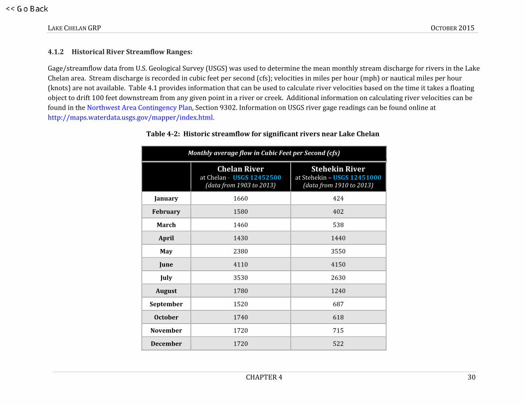
4.1.2 Historical River Streamflow Ranges:
Gage/streamflow data from U.S. Geological Survey (USGS) was used to determine the mean monthly stream discharge for rivers in the Lake
Chelan area. Stream discharge is recorded in cubic feet per second (cfs); velocities in miles per hour (mph) or nautical miles per hour
(knots) are not available. Table 4.1 provides information that can be used to calculate river velocities based on the time it takes a floating
object to drift 100 feet downstream from any given point in a river or creek. Additional information on calculating river velocities can be
found in the Northwest Area Contingency Plan, Section 9302. Information on USGS river gage readings can be found online at
http://maps.waterdata.usgs.gov/mapper/index.html.
Table 4-2: Historic streamflow for significant rivers near Lake Chelan
Monthly average flow in Cubic Feet per Second (cfs)
Chelan River at Chelan - USGS 12452500
(data from 1903 to 2013)
Stehekin River at Stehekin – USGS 12451000
(data from 1910 to 2013)
January 1660 424
February 1580 402
March 1460 538
April 1430 1440
May 2380 3550
June 4110 4150
July 3530 2630
August 1780 1240
September 1520 687
October 1740 618
November 1720 715
December 1720 522

LAKE CHELAN GRP OCTOBER 2015
CHAPTER 4 31
Figure 4-1: Historic streamflow for significant rivers near Lake Chelan
LAKE CHELAN GRP OCTOBER 2015
CHAPTER 4 32
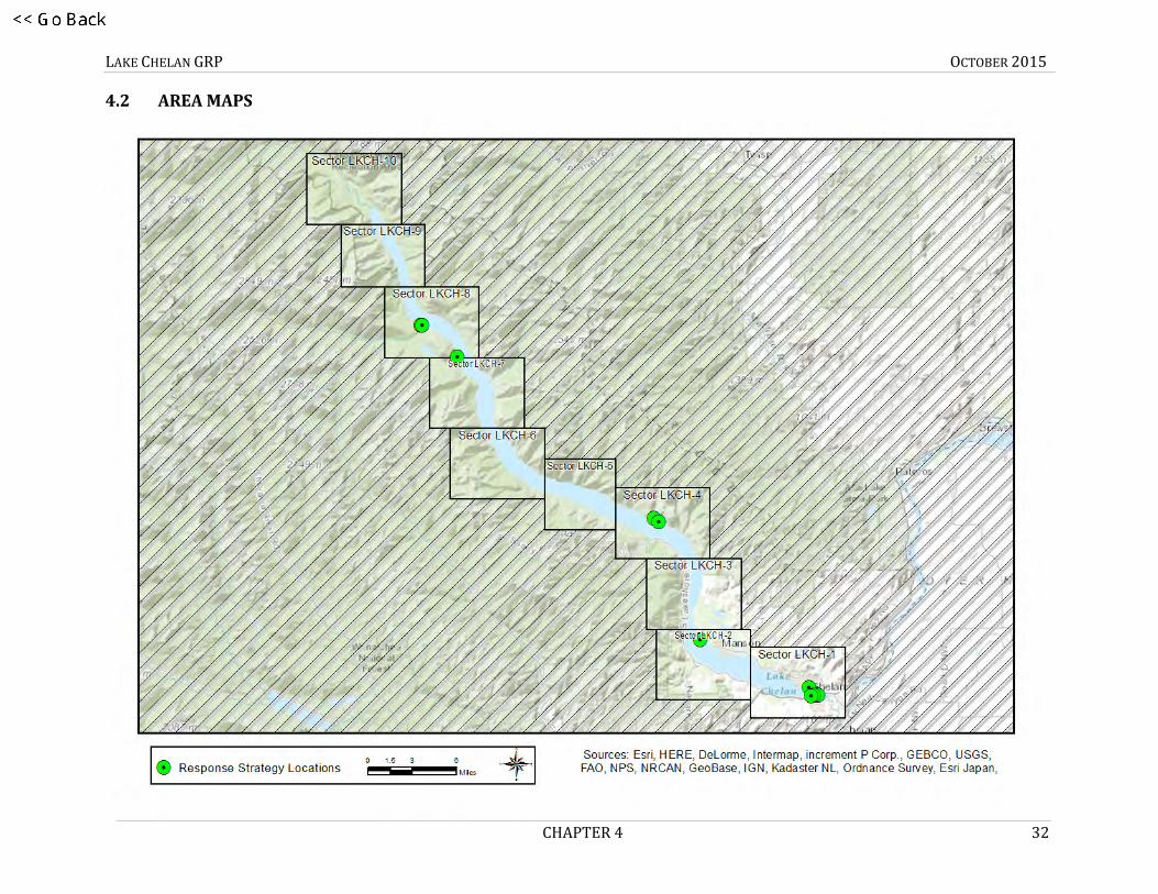
4.2 AREA MAPS
Area – Response
b30

LAKE CHELAN GRP OCTOBER 2015
CHAPTER 4 33
Area - Notification

LAKE CHELAN GRP OCTOBER 2015
CHAPTER 4 34
Area – Staging

LAKE CHELAN GRP OCTOBER 2015
CHAPTER 4 35
Area – Boat Launch

LAKE CHELAN GRP OCTOBER 2015
CHAPTER 4 36
Area – Spill Origin Points
LKCH-A
LKCH-B
LKCH-C
LKCH-D

LAKE CHELAN GRP OCTOBER 2015
CHAPTER 4 37
4.3 STRATEGY AND RESPONSE PRIORITIES
4.3.1 General Response Priorities
The following list provides the order of response priorities after an oil spill into Lake Chelan.
1. Safety is always the number one priority. Do not implement GRP strategies or take actions that will unduly jeopardize public, worker, or personal safety.
2. Notify local public health and safety personnel.
3. Control and contain the source of the spill; mobilize resources to the spill location. Source control and containment are always a higher priority than the implementation of GRP strategies.
4. Determine the priority or order GRP strategies should be implemented based on the location of the spill or affected area. Priorities based on Potential Oil Spill Origin Points are included in this chapter and should be used unless the situation or circumstances dictate otherwise (see Section 4.3.2).
5. As response resources become available, implement the GRP Strategies in order of priority.
6. In Washington State, if strategy implementation reduces, interrupts, or diverts the flow of water in streams, including the installation of a culvert block or underflow dam, an Emergency HPA must be obtained from WDFW (24-hour pager: (360) 534-8233).
4.3.2 Strategy Priorities based on Potential Oil Spill Origin Points
POSOPs are geographic locations that have a defined list of response strategy implementation priorities listed in a matching table of
Section 4.3. The placement of each POSOP is often based on spill risks in the area, including oil pipelines, railways, highways/roadways,
tributaries, and vessel movements. Intersections of two or more of these risk locations typically represent a higher spill risk than any one
individually, increasing the probability of an oil spill. Occasionally POSOPs are generalized to ensure implementation priorities are
developed throughout an entire planning area.
These points are displayed on area overview and sector maps as red boxes. In establishing response priorities during a response, or
selecting an appropriate POSOP, the downstream and tidal movement of spilled oil and the time it takes to mobilize and deploy response
resources must be considered. Generally, GRP strategies should first be implemented downstream, well beyond the furthest extent of the
c35

LAKE CHELAN GRP OCTOBER 2015
CHAPTER 4 38
spill, with deployments continuing upstream towards the spill source and in some cases slightly beyond. POSOPs are alphabetically
designated.
The following tables provide the strategy implementation order for POSOPs in Lake Chelan: LKCH-A, LKCH-B, LKCH-C and LKCH-D. These
priority tables were determined using a combination of variables, including: notification time, travel time for responders and equipment,
average and seasonal flow rates, average winds, tides or currents, deployment time, proximity to the spill source, and other considerations.
Source control and containment are a higher priority than GRP strategy implementation

LAKE CHELAN GRP OCTOBER 2015
CHAPTER 4 39
Table 4-3: Priority Table LKCH-A (Barge Loading Dock in Chelan)
LKCH-A (Barge Loading Dock in Chelan)
Implementation Priority
Strategy Number
Sector Map (Page #)
Strategy Matrix (Page #)
Strategy Details (Page #) Remarks
1 LKCH-60.6 43 55 73 N/A
2 LKCH-58.9 43 55 71 Low Lake Level Only
3 LKCH-60.8 43 55 75 N/A
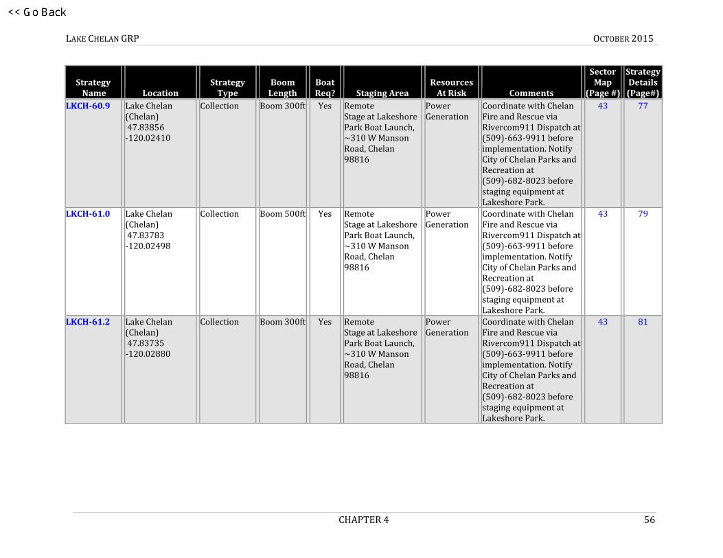
4 LKCH-60.9 43 56 77 N/A
5 LKCH-61.0 43 56 79 N/A
6 LKCH-61.2 43 56 81 N/A
7 LKCH-48.0 44 54 69 N/A
8 LKCH-37.5 46 54 67 N/A
9 LKCH-37.0 46 54 65 N/A
10 LKCH-104.4 50 57 83 High Lake Level Only

LAKE CHELAN GRP OCTOBER 2015
CHAPTER 4 40
Table 4-4: Priority Table LKCH-B (Manson)
LKCH-B (Manson)
Implementation Priority
Strategy Number
Sector Map (Page #)
Strategy Matrix (Page #)
Strategy Details (Page #) Remarks
1 LKCH-48.0 44 54 69 N/A
2 LKCH-58.9 43 55 71 Low Lake Level Only
3 LKCH-60.6 43 55 73 N/A
4 LKCH-37.5 46 54 67 N/A
5 LKCH-37.0 46 54 65 N/A
6 LKCH-104.4 50 57 83 High Lake Level Only

LAKE CHELAN GRP OCTOBER 2015
CHAPTER 4 41
Table 4-5: Priority Table LKCH-C (Dutch Harbor)
LKCH-C (Dutch Harbor)
Implementation Priority
Strategy Number
Sector Map (Page #)
Strategy Matrix (Page #)
Strategy Details (Page #) Remarks
1 LKCH-37.0 46 54 65 N/A
2 LKCH-37.5 46 54 67 N/A
3 LKCH-48.0 44 54 69 N/A
4 LKCH-58.9 43 55 71 Low Lake Level Only
5 LKCH-60.6 43 55 73 N/A
6 LKCH-104.4 50 57 83 High Lake Level Only

LAKE CHELAN GRP OCTOBER 2015
CHAPTER 4 42
Table 4-6: Priority Table LKCH-D (Lucerne Landing)
LKCH-D (Lucerne Landing)
Implementation Priority
Strategy Number
Sector Map (Page #)
Strategy Matrix (Page #)
Strategy Details (Page #) Remarks
1 LKCH-108.4 50 57 87 N/A
2 LKCH-108.5 50 58 89 N/A
3 LKCH-108.3 50 57 85 N/A
4 LKCH-104.4 50 57 83 High Lake Level Only
5 LKCH-37.0 46 54 65 N/A
6 LKCH-37.5 46 54 67 N/A
7 LKCH-48.0 44 54 69 N/A
8 LKCH-58.9 43 55 71 Low Lake Level Only
9 LKCH-60.6 43 55 73 N/A

LAKE CHELAN GRP OCTOBER 2015
CHAPTER 4 43
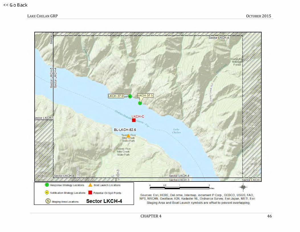
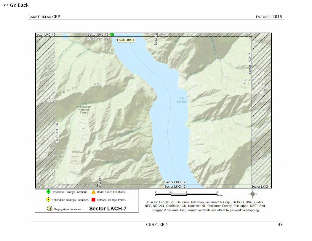
4.4 SECTOR MAPS (STRATEGY LOCATIONS)
SECTOR MAP LKCH-1
1SECTOR MAP LKCH-1
d4-21
e41
LKCH-A

LAKE CHELAN GRP OCTOBER 2015
CHAPTER 4 44
2SECTOR MAP LKCH-2f4-22

LAKE CHELAN GRP OCTOBER 2015
CHAPTER 4 45
3SECTOR MAP LKCH-3g4-23
LAKE CHELAN GRP OCTOBER 2015
CHAPTER 4 46
4SECTOR MAP LKCH-4h4-24

LAKE CHELAN GRP OCTOBER 2015
CHAPTER 4 47
5Sector Map LKCH-5i4-25

LAKE CHELAN GRP OCTOBER 2015
CHAPTER 4 48
6 LKCH-6
LAKE CHELAN GRP OCTOBER 2015
CHAPTER 4 49
7 LKCH-7

LAKE CHELAN GRP OCTOBER 2015
CHAPTER 4 50
8 LKCH-8

LAKE CHELAN GRP OCTOBER 2015
CHAPTER 4 51
9 LKCH-9

LAKE CHELAN GRP OCTOBER 2015
CHAPTER 4 52
10LKCH-10

LAKE CHELAN GRP OCTOBER 2015
CHAPTER 4 53
4.5 MATRICES
4.5.1 Strategy Names
Each strategy in this document has been given a “Short Name” which includes one to six letters denoting the associated waterbody.
Following the letters are numbers that specify the location. On rivers or other linear waterbodies, the location is named by river mile: the
distance from the mouth of the river or creek upstream to the strategy location. Some short names indicate whether the strategy is located
on river right, river left, or mid-river by an “R”, “L” or “M” after the river mile. On lakes, the numbers indicate the location by shoreline
mile, typically starting in the northwest corner and increasing clockwise around the lake. In marine areas, the numbers do not have a
geographic meaning. Notification strategies are indicated by an “-N” at the end of the name. Staging Areas and Boat Launches are
indicated by an “SA-“ or “BL-“ at the beginning of the short name.
Associated waterbody short name designations used within this plan include:
LKCH = Lake Chelan N = Notification Strategy
SA = Staging Area
BL = Boat Launch
j46

LAKE CHELAN GRP OCTOBER 2015
CHAPTER 4 54
4.5.2 Response Strategy Matrices
Strategy Name
Location
Strategy Type
Boom Length
Boat Req?
Staging Area
Resources At Risk
Comments
Sector Map
(Page #)
Strategy Details (Page#)
LKCH-37.0 Lake Chelan (Dutch Harbor) 48.01229 -120.25733
Exclusion Boom 650ft Yes Remote Coordinate with incident/unified command (or call Ecology) before staging in Chelan at SA-LKCH-61.5 Mountain Barge.
Sensitive Resources
Coordinate transit to strategy location with incident/unified command or call Ecology (509)-575-2490. Nearest boat ramp (lake above 1093' only) is BL-LKCH-82.6 – South across the lake. In low water use BL-LKCH-71.4 (~10 mi S).
46 65
LKCH-37.5 Lake Chelan (Dutch Harbor) 48.00900 -120.25005
Exclusion Boom 800ft Yes Remote Coordinate with incident/unified command (or call Ecology) before staging in Chelan at SA-LKCH-61.5 Mountain Barge.
Sensitive Resources
Coordinate transit to strategy location with incident/unified command or call Ecology (509)-575-2490. Nearest boat ramp (lake above 1093' only) is BL-LKCH-82.6 – South across the lake. In low water use BL-LKCH-71.4 (~10 mi S).
46 67
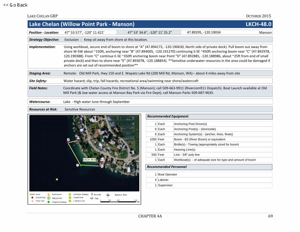
LKCH-48.0 Lake Chelan (Willow Point Park - Manson) 47.89295 -120.19034
Exclusion Boom 1050ft
Yes Remote Old Mill Park, Hwy 150 and E. Wapato Lake Rd (200 Mill Rd, Manson, WA) – about 4 miles away from site
Sensitive Resources
Coordinate with Chelan County Fire District No. 5 (Manson); call (509)-663-9911 (Rivercom911 Dispatch). Boat Launch available at Old Mill Park (and low water access at Manson Bay Park via Fire Dept); call Manson Parks (509)-687-9635.
44 69
k4-27
l47

LAKE CHELAN GRP OCTOBER 2015
CHAPTER 4 55
Strategy Name
Location
Strategy Type
Boom Length
Boat Req?
Staging Area
Resources At Risk
Comments
Sector Map
(Page #)
Strategy Details (Page#)
LKCH-58.9 Low Lake Levels Only
Lake Chelan (Chelan/ Spaders Bay) 47.84538 -120.03182
Exclusion Boom 1150ft
Yes Remote Stage at Lakeshore Park Boat Launch, ~310 W Manson Road, Chelan 98816
Sensitive Resources
Coordinate with Chelan Fire & Rescue via Rivercom911 Dispatch at (509) 663-9911 before implementation. Notify City of Chelan Parks and Recreation at 509-682-8023 before staging equipment at Lakeshore Park.
43 71
LKCH-60.6 Lake Chelan (Chelan) 47.83802 -120.01837
Collection, Exclusion
Boom 700ft Yes Remote Stage at Lakeshore Park Boat Launch, ~310 W Manson Road, Chelan 98816
Power Generation
Coordinate with Chelan Fire and Rescue via Rivercom911 Dispatch at (509)-663-9911 before implementation. Notify City of Chelan Parks and Recreation at (509)-682-8023 before staging equipment at Lakeshore Park.
43 73
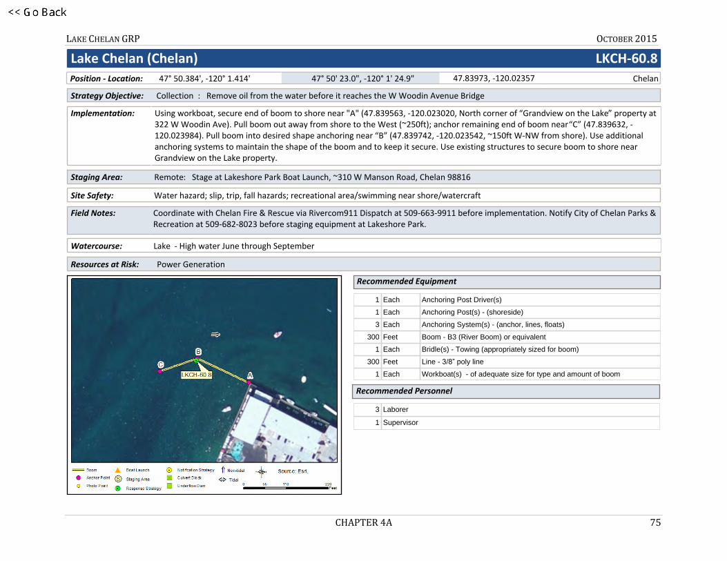
LKCH-60.8 Lake Chelan (Chelan) 47.83973 -120.02357
Collection Boom 300ft Yes Remote Stage at Lakeshore Park Boat Launch, ~310 W Manson Road, Chelan 98816
Power Generation
Coordinate with Chelan Fire and Rescue via Rivercom911 Dispatch at (509)-663-9911 before implementation. Notify City of Chelan Parks and Recreation at (509)-682-8023 before staging equipment at Lakeshore Park.
43 75
m4-
28
LAKE CHELAN GRP OCTOBER 2015
CHAPTER 4 56
Strategy Name
Location
Strategy Type
Boom Length
Boat Req?
Staging Area
Resources At Risk
Comments
Sector Map
(Page #)
Strategy Details (Page#)
LKCH-60.9 Lake Chelan (Chelan) 47.83856 -120.02410
Collection Boom 300ft Yes Remote Stage at Lakeshore Park Boat Launch, ~310 W Manson Road, Chelan 98816
Power Generation
Coordinate with Chelan Fire and Rescue via Rivercom911 Dispatch at (509)-663-9911 before implementation. Notify City of Chelan Parks and Recreation at (509)-682-8023 before staging equipment at Lakeshore Park.
43 77
LKCH-61.0 Lake Chelan (Chelan) 47.83783 -120.02498
Collection Boom 500ft Yes Remote Stage at Lakeshore Park Boat Launch, ~310 W Manson Road, Chelan 98816
Power Generation
Coordinate with Chelan Fire and Rescue via Rivercom911 Dispatch at (509)-663-9911 before implementation. Notify City of Chelan Parks and Recreation at (509)-682-8023 before staging equipment at Lakeshore Park.
43 79
LKCH-61.2 Lake Chelan (Chelan) 47.83735 -120.02880
Collection Boom 300ft Yes Remote Stage at Lakeshore Park Boat Launch, ~310 W Manson Road, Chelan 98816
Power Generation
Coordinate with Chelan Fire and Rescue via Rivercom911 Dispatch at (509)-663-9911 before implementation. Notify City of Chelan Parks and Recreation at (509)-682-8023 before staging equipment at Lakeshore Park.
43 81
n4-29

LAKE CHELAN GRP OCTOBER 2015
CHAPTER 4 57
Strategy Name
Location
Strategy Type
Boom Length
Boat Req?
Staging Area
Resources At Risk
Comments
Sector Map
(Page #)
Strategy Details (Page#)
LKCH-104.4 Low Lake Levels Only
Lake Chelan 48.17123 -120.54483
Exclusion Boom 250ft Yes Remote Coordinate with incident command (or call Ecology) before staging in Chelan at SA-LKCH-61.5 Mountain Barge.
Sensitive Resources
Coordinate transit to strategy location with incident/unified command or call Ecology (509)-575-2490. Nearest boat ramp (lake above 1093' only) is BL-LKCH-82.6 (~20 mi S). In low water use BL-LKCH-71.4 (~30 mi S).
50 83
LKCH-108.3 Lake Chelan (Lucerne Landing) 48.20220 -120.59654
Diversion Boom 100ft Yes Onsite Shoreside of dock at Lucerne Landing.
Sensitive Resources
Coordinate transit to Lucerne Landing with incident/unified command or call Ecology (509)-575-2490. Nearest boat ramp (lake above 1093' only) is BL-LKCH-82.6 (~23 mi S). In low water use BL-LKCH-71.4 (~33 mi S).
50 85
LKCH-108.4 Lake Chelan (Lucerne Landing) 48.20166 -120.59835
Containment Boom 500ft Yes Onsite Shoreside of dock at Lucerne Landing.
Sensitive Resources
Coordinate transit to Lucerne Landing with incident/unified command or call Ecology (509)-575-2490. Nearest boat ramp (lake above 1093' only) is BL-LKCH-82.6 (~23 mi S). In low water use BL-LKCH-71.4 (~33 mi S).
50 87
o4-30

LAKE CHELAN GRP OCTOBER 2015
CHAPTER 4 58
Strategy Name
Location
Strategy Type
Boom Length
Boat Req?
Staging Area
Resources At Risk
Comments
Sector Map
(Page #)
Strategy Details (Page#)
LKCH-108.5 Lake Chelan (Lucerne Landing) 48.20191 -120.59892
Containment Boom 800ft Yes Onsite Shoreside of dock at Lucerne Landing.
Sensitive Resources
Coordinate transit to Lucerne Landing with incident/unified command or call Ecology (509)-575-2490. Nearest boat ramp (lake above 1093' only) is BL-LKCH-82.6 (~23 mi S). In low water use BL-LKCH-71.4 (~33 mi S).
50 89
p4-31

LAKE CHELAN GRP OCTOBER 2015
CHAPTER 4 59
4.5.3 Notification Strategy Matrices
Strategy Name
Location
Strategy Type
Resources at Risk
Implementation
Comments
Sector Map
(Page #)
Strategy Details (Page#)
LKCH-2.8-N National Park Service Stehekin Ranger Station 48.30838 -120.65643
Notification Federal Lands, Marina, Public Recreation Site/Area, Wetlands
Call the NPS Stehekin Ranger's Station at (509) 699-2080 x 29 (24-hr number).
Notify park staff of oil spill so they can deploy response equipment.
52 93
LKCH-47.5-N Lake Chelan Reclamation District Water Intake 47.89977 -120.19240
Notification Public Health and Safety, Water Intakes
Call Lake Chelan Notification District emergency line at (509) 687-3548. Inform them that a spill has occurred and to consider shutting down their intakes.
Shut down drinking water and irrigation intakes.
44 95
LKCH-60.1-N City of Chelan Drinking Water Intake 47.83634 -120.01575
Notification Public Health and Safety, Water Intakes
Call City of Chelan Public Works and inform them a spill has occurred. Advise they consider shutting down their intakes.
Shut down drinking water intake and park irrigation intakes.
43 97
LKCH-60.2-N Lake Chelan Hydroelectric Project 47.83447 -120.01246
Notification Power Generation, Salmon Bearing Stream
Call System Operations at (509) 661-4000 (staffed 24/7). They will deploy response equipment and/or adjust water intakes.
Keep oil out of dam 43 99
q4-32
r52

LAKE CHELAN GRP OCTOBER 2015
CHAPTER 4 60
4.5.4 Staging Area Matrices
Strategy Name
Name
Position
Nearest Address
Contact
Strategies Served
Comments
Sector Map
(Page #)
Strategy Details (Page#)
SA-LKCH-59.3 Lakeshore Park Marina
47.84179 -120.02438
310 W Manson Road Chelan, WA 98816
City of Chelan Parks and Recreation Owner Chelan, WA 98816 509-682-8023
LKCH-58.9 LKCH-60.6 LKCH-60.8 LKCH-60.9 LKCH-61.0 LKCH-61.2
Pump-out station, launch and ample pay parking. Adjacent to RV Park with utilities and wi-fi.
43 103
SA-LKCH-61.5
Mountain Barge Services
47.83607 -120.03427
1228 W Woodin Ave Chelan, WA 98816
Mountain Barge Services Chelan, WA 98816 509-682-2493
LKCH-37.0 LKCH-37.5
(Previously Tom Courtney Tug and Barge). Barge to Lucerne Landing loading and departure site. Response will be coordinated from here.
43 105
SA-LKCH-71.4 Lake Chelan State Park
47.87544 -120.19691
7544 S. Lakeshore Road Chelan, WA 98816
Washington State Parks and Recreation Commission
Lake Chelan State Park Chelan, WA 98816 509-687-3710
LKCH-48.0 The park provides one kitchen shelter without electricity plus a small parking area.
44 107
s4-33
t53

LAKE CHELAN GRP OCTOBER 2015
CHAPTER 4 61
4.5.5 Boat Launch Location Matrices
Strategy Name
Name
Position
Nearest Address
Contact
Strategies Served
Comments
Sector Map
(Page #)
Strategy Details (Page#)
BL-LKCH-59.3 Lakeshore Park Marina
47.84179 -120.02438
310 W Manson Road Chelan, WA 98816
City of Chelan Parks and Recreation Owner Chelan, WA 98816 509-682-8023
LKCH-58.9 LKCH-60.6 LKCH-60.8 LKCH-60.9 LKCH-61.0 LKCH-61.2
Pump-out station, launch and ample pay parking. Adjacent to RV Park with utilities and wi-fi.
44 111
BL-LKCH-71.4 Lake Chelan State Park
47.87544 -120.19691
7544 S. Lakeshore Road Chelan, WA 98816
Washington State Parks and Recreation Commission Lake Chelan State Park Chelan, WA 98816 509-687-3710
LKCH-48.0 Accessible in low water. The park has a double lane boat launch with nearby parking for approximately 32 vehicles with trailers. The launch offers a 1080 feet of docking space along the four piers near the launch.
44 113
23BL-LKCH-82.6 BL-LKCH-82.6
25-Mile Creek Boat Launch
47.99316 -120.26120
20530 S Lakeshore Rd Chelan, WA 98816
Washington State Parks Chelan Owner Chelan, WA 98816 360-902-8844
LKCH-37.0 LKCH-37.5 LKCH-104.4 LKCH-108.3 LKCH-108.4 LKCH-108.5
Twenty-Five Mile Creek State Park offers two boat ramps. The launch is generally usable from mid-June to the end of December, as long as the lake is at an elevation of 1093. For up-to-date information, call the Information Center at 360-902-8844. There is a modern marina with moorage for 20 boats up to 23 feet long.
46 115
u4-34v54

LAKE CHELAN GRP OCTOBER 2015
CHAPTER 4A 62
This page was intentionally left blank.
w55

LAKE CHELAN GRP OCTOBER 2015
CHAPTER 4A 63
APPENDIX 4A
Response Strategy 2-Pagers

LAKE CHELAN GRP OCTOBER 2015
CHAPTER 4A 64
RESPONSE STRATEGIES – LIST
LKCH-37.0 LKCH-37.5 LKCH-48.0 LKCH-58.9 LKCH-60.6
LKCH-60.8 LKCH-60.9 LKCH-61.0 LKCH-61.2 LKCH-104.4
LKCH-108.3 LKCH-108.4 LKCH-108.5
LAKE CHELAN GRP OCTOBER 2015
CHAPTER 4A 65
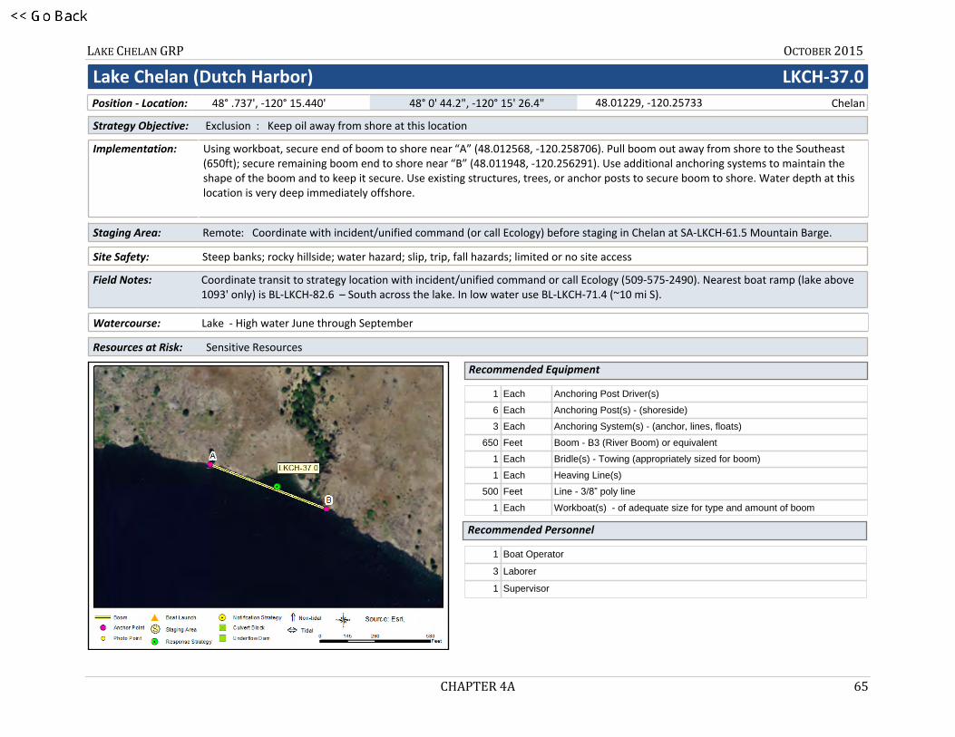
1LKCH-37.0
Lake Chelan (Dutch Harbor) LKCH-37.0
Site Safety: Steep banks; rocky hillside; water hazard; slip, trip, fall hazards; limited or no site access
Staging Area: Remote: Coordinate with incident/unified command (or call Ecology) before staging in Chelan at SA-LKCH-61.5 Mountain Barge.
Using workboat, secure end of boom to shore near “A” (48.012568, -120.258706). Pull boom out away from shore to the Southeast (650ft); secure remaining boom end to shore near “B” (48.011948, -120.256291). Use additional anchoring systems to maintain the shape of the boom and to keep it secure. Use existing structures, trees, or anchor posts to secure boom to shore. Water depth at this location is very deep immediately offshore.
Coordinate transit to strategy location with incident/unified command or call Ecology (509-575-2490). Nearest boat ramp (lake above 1093' only) is BL-LKCH-82.6 – South across the lake. In low water use BL-LKCH-71.4 (~10 mi S).
Watercourse: Lake - High water June through September
Resources at Risk: Sensitive Resources
Strategy Objective: Exclusion : Keep oil away from shore at this location
Recommended Equipment
Recommended Personnel
Implementation:
Field Notes:
1 Each Anchoring Post Driver(s)
6 Each Anchoring Post(s) - (shoreside)
3 Each Anchoring System(s) - (anchor, lines, floats)
650 Feet Boom - B3 (River Boom) or equivalent
1 Each Bridle(s) - Towing (appropriately sized for boom)
1 Each Heaving Line(s)
500 Feet Line - 3/8” poly line
1 Each Workboat(s) - of adequate size for type and amount of boom
1 Boat Operator
3 Laborer
1 Supervisor
Chelan48.01229, -120.25733 48° 0' 44.2", -120° 15' 26.4" 48° .737', -120° 15.440' Position - Location:

LAKE CHELAN GRP OCTOBER 2015
CHAPTER 4A 66
Lake Chelan (Dutch Harbor) LKCH-37.0
LKCH-37.0 Photo: Aerial photo looking NNE at strategy location
Nearest Address
Site Contact
1228 W Woodin AveChelan, WA 98816
Mountain Barge ServicesPrimary Contact : 509-682-2493
U.S. Forest Service Okanogan-Wenatchee National ForestLand/Property Owner : 509-664-9254
Driving Directions
1. From I-90, take exit 149 for State Route 281 S toward Quincy/ Wenatchee 2. Go north on WA-281 (State Route 281 N)3. Turn left on WA-28 (F St SW)4. Turn left on US-2 (US-97)5. Take ramp on the right to US-97-Alt N toward Entiat/Chelan6. Turn right on US-97-ALT (State Highway 97a)7. Finish at 1222 W Woodin Avenue, 98816, on the left

LAKE CHELAN GRP OCTOBER 2015
CHAPTER 4A 67
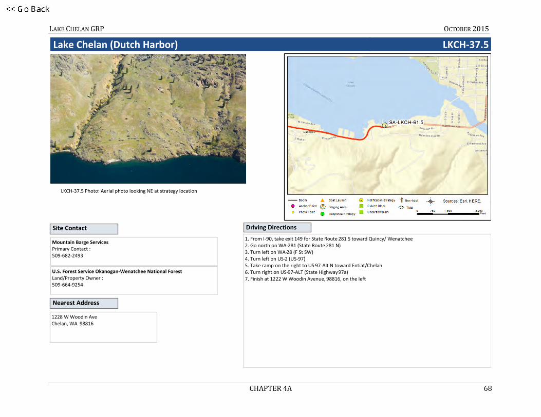
2LKCH-37.5
Lake Chelan (Dutch Harbor) LKCH-37.5
Site Safety: Steep banks; rocky hillside; water hazard; slip, trip, fall hazards; limited or no site access
Staging Area: Remote: Coordinate with incident/unified command (or call Ecology) before staging in Chelan at SA-LKCH-61.5 Mountain Barge.
Using workboat, secure end of boom to shore near “A” (48.009623, -120.250955). Pull boom out away from shore to the SE (750ft to 800ft); secure remaining boom end to shore near “C” (48.008417, -120.248527). Pull boom into desired shape anchoring near “B” (48.009077, -120.250505 – 60ft off shore, about ~225ft SSE of “A”). Use additional anchoring systems to maintain the shape of the boom and to keep it secure. Use existing structures, trees, or anchor posts to secure boom to shore. Water depth is very deep immediately offshore.
Coordinate transit to strategy location with incident/unified command or call Ecology (509-575-2490). Nearest boat ramp (lake above 1093' only) is BL-LKCH-82.6 – South across the lake. In low water use BL-LKCH-71.4 (~10 mi S).
Watercourse: Lake - High water June through September
Resources at Risk: Sensitive Resources
Strategy Objective: Exclusion : Keep oil away from shore at this location
Recommended Equipment
Recommended Personnel
Implementation:
Field Notes:
1 Each Anchoring Post Driver(s)
6 Each Anchoring Post(s) - (shoreside)
5 Each Anchoring System(s) - (anchor, lines, floats)
800 Feet Boom - B3 (River Boom) or equivalent
1 Each Bridle(s) - Towing (appropriately sized for boom)
1 Each Heaving Line(s)
500 Feet Line - 3/8” poly line
1 Each Workboat(s) - of adequate size for type and amount of boom
1 Boat Operator
3 Laborer
1 Supervisor
Chelan48.00900, -120.25005 48° 0' 32.4", -120° 15' .2" 48° .540', -120° 15.003' Position - Location:
LAKE CHELAN GRP OCTOBER 2015
CHAPTER 4A 68
Lake Chelan (Dutch Harbor) LKCH-37.5
LKCH-37.5 Photo: Aerial photo looking NE at strategy location
Nearest Address
Site Contact
1228 W Woodin AveChelan, WA 98816
Mountain Barge ServicesPrimary Contact : 509-682-2493
U.S. Forest Service Okanogan-Wenatchee National ForestLand/Property Owner : 509-664-9254
Driving Directions
1. From I-90, take exit 149 for State Route 281 S toward Quincy/ Wenatchee 2. Go north on WA-281 (State Route 281 N)3. Turn left on WA-28 (F St SW)4. Turn left on US-2 (US-97)5. Take ramp on the right to US-97-Alt N toward Entiat/Chelan6. Turn right on US-97-ALT (State Highway 97a)7. Finish at 1222 W Woodin Avenue, 98816, on the left
LAKE CHELAN GRP OCTOBER 2015
CHAPTER 4A 69
3LKCH-48.0
Lake Chelan (Willow Point Park - Manson) LKCH-48.0
Site Safety: Water hazard; slip, trip, fall hazards; recreational area/swimming near shore/watercraft
Staging Area: Remote: Old Mill Park, Hwy 150 and E. Wapato Lake Rd (200 Mill Rd, Manson, WA) – about 4 miles away from site
Using workboat, secure end of boom to shore at “A” (47.894172, -120.190630, North side of private dock). Pull boom out away from shore W-SW about ~150ft, anchoring near “B” (47.894005, -120.191270) continuing S-SE ~450ft anchoring boom near “C” (47.892978, -120.190388). From “C” continue E-SE ~350ft anchoring boom near Point “D” (47.892885, -120.188986, about ~25ft from end of small private dock) and then to shore near “E” (47.893078, -120.188854). **Sensitive underwater resources in the area could be damaged if anchors are set out of recommended position**
Coordinate with Chelan County Fire District No. 5 (Manson); call 509-663-9911 (Rivercom911 Dispatch). Boat Launch available at Old Mill Park (& low water access at Manson Bay Park via Fire Dept); call Manson Parks 509-687-9635.
Watercourse: Lake - High water June through September
Resources at Risk: Sensitive Resources
Strategy Objective: Exclusion : Keep oil away from shore at this location.
Recommended Equipment
Recommended Personnel
Implementation:
Field Notes:
1 Each Anchoring Post Driver(s)
6 Each Anchoring Post(s) - (shoreside)
6 Each Anchoring System(s) - (anchor, lines, floats)
1050 Feet Boom - B3 (River Boom) or equivalent
1 Each Bridle(s) - Towing (appropriately sized for boom)
1 Each Heaving Line(s)
500 Feet Line - 3/8” poly line
1 Each Workboat(s) - of adequate size for type and amount of boom
1 Boat Operator
4 Laborer
1 Supervisor
Manson47.89295, -120.19034 47° 53' 34.6", -120° 11' 25.2" 47° 53.577', -120° 11.421' Position - Location:
LAKE CHELAN GRP OCTOBER 2015
CHAPTER 4A 70
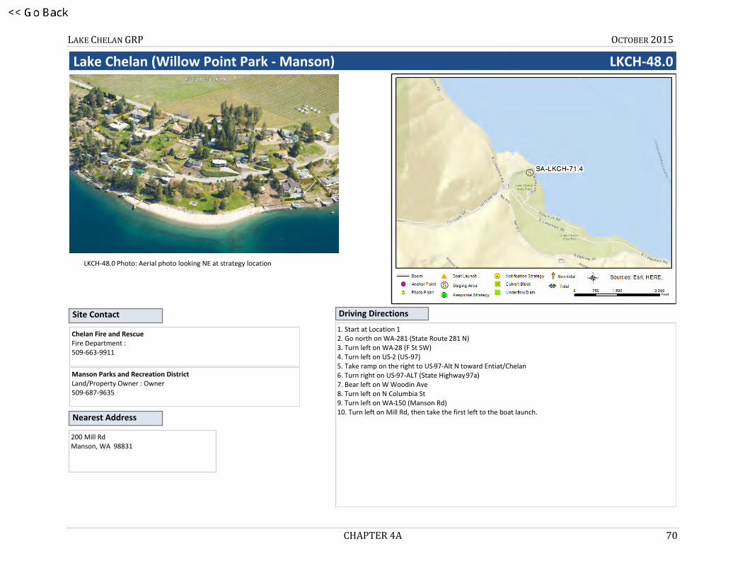
Lake Chelan (Willow Point Park - Manson) LKCH-48.0
LKCH-48.0 Photo: Aerial photo looking NE at strategy location
Nearest Address
Site Contact
200 Mill RdManson, WA 98831
Chelan Fire and RescueFire Department : 509-663-9911
Manson Parks and Recreation DistrictLand/Property Owner : Owner509-687-9635
Driving Directions
1. Start at Location 12. Go north on WA-281 (State Route 281 N)3. Turn left on WA-28 (F St SW)4. Turn left on US-2 (US-97)5. Take ramp on the right to US-97-Alt N toward Entiat/Chelan6. Turn right on US-97-ALT (State Highway 97a)7. Bear left on W Woodin Ave8. Turn left on N Columbia St9. Turn left on WA-150 (Manson Rd)10. Turn left on Mill Rd, then take the first left to the boat launch.

LAKE CHELAN GRP OCTOBER 2015
CHAPTER 4A 71
4LKCH-58.9
Lake Chelan (Chelan/Spaders Bay) LKCH-58.9
Site Safety: Water hazard; slip, trip, fall hazards; recreational area/swimming near shore/watercraft
Staging Area: Remote: Stage at Lakeshore Park Boat Launch, ~310 W Manson Road, Chelan 98816
Using workboat, secure end of boom to shore using existing structures near “A” (47.846758, -120.031990, end of dirt road West of Spader Bay Condominiums). Pull boom away from shore and SE to corner of boat dock at Spader Bay Condominiums. Secure boom to SW corner of dock at “D” (47.844743, -120.029993). Pull boom into desired shape anchoring it at “B” (47.845666, -120.032324, ~400ft from shore at “A”) and "C” (47.844736, -120.030761, ~190ft West of dock at “D”). **Sensitive underwater resources in the area could be damaged if anchors are set out of recommended position**
Coordinate with Chelan Fire & Rescue via Rivercom911 Dispatch at 509-663-9911 before implementation. Notify City of Chelan Parks & Recreation at 509-682-8023 before staging equipment at Lakeshore Park.
Watercourse: Lake - High water June through September
Resources at Risk: Sensitive Resources
Strategy Objective: Exclusion : Prevent oil from entering this part of Spaders Bay during periods of Low Lake Level Only
Recommended Equipment
Recommended Personnel
Implementation:
Field Notes:
1 Each Anchoring Post Driver(s)
3 Each Anchoring Post(s) - (shoreside)
7 Each Anchoring System(s) - (anchor, lines, floats)
1150 Feet Boom - B3 (River Boom) or equivalent
1 Each Bridle(s) - Towing (appropriately sized for boom)
1 Each Heaving Line(s)
300 Feet Line - 3/8” poly line
1 Each Workboat(s) - of adequate size for type and amount of boom
1 Boat Operator
5 Laborer
1 Supervisor
Chelan47.84538, -120.03182 47° 50' 43.4", -120° 1' 54.5" 47° 50.723', -120° 1.909' Position - Location:
LAKE CHELAN GRP OCTOBER 2015
CHAPTER 4A 72
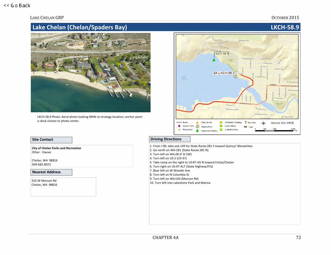
Lake Chelan (Chelan/Spaders Bay) LKCH-58.9
LKCH-58.9 Photo: Aeral photo looking NNW at strategy location; anchor point is dock closest to photo center.
Nearest Address
Site Contact
310 W Manson RdChelan, WA 98816
City of Chelan Parks and RecreationOther : Owner
Chelan, WA 98816509-682-8023
Driving Directions
1. From I-90, take exit 149 for State Route 281 S toward Quincy/ Wenatchee 2. Go north on WA-281 (State Route 281 N)3. Turn left on WA-28 (F St SW)4. Turn left on US-2 (US-97)5. Take ramp on the right to US-97-Alt N toward Entiat/Chelan6. Turn right on US-97-ALT (State Highway 97a)7. Bear left on W Woodin Ave8. Turn left on N Columbia St9. Turn left on WA-150 (Manson Rd)10. Turn left into Lakeshore Park and Marina

LAKE CHELAN GRP OCTOBER 2015
CHAPTER 4A 73
5LKCH-60.6
Lake Chelan (Chelan) LKCH-60.6
Site Safety: Water hazard; slip, trip, fall hazards; recreational area/watercraft
Staging Area: Remote: Stage at Lakeshore Park Boat Launch, ~310 W Manson Road, Chelan 98816
Using workboat, secure end of boom to shore along Chelan Riverwalk Loop Trail at "A" (47.838166, -120.019750, end of dirt road near corner off W. Okanogan Avenue near corner of S 1st Street). Pull boom out away from shore, SE across to Riverwalk Park (opposite shore). Secure remaining end of boom near "B" (47.837736, -120.017185, South of parking area on Emerson Street). Form collection pocket along Riverwalk Park to the NNW. Use additional anchoring systems to maintain the shape of the boom and to keep it secure. Use existing structures or anchor post to secure boom to shore.
Coordinate with Chelan Fire & Rescue via Rivercom911 Dispatch at 509-663-9911 before implementation. Notify City of Chelan Parks & Recreation at 509-682-8023 before staging equipment at Lakeshore Park.
Watercourse: Lake - High water June through September
Resources at Risk: Power Generation
Strategy Objective: Collection, Exclusion : Prevent oil from reaching Lake Chelan Dam
Recommended Equipment
Recommended Personnel
Implementation:
Field Notes:
1 Each Anchoring Post Driver(s)
6 Each Anchoring Post(s) - (shoreside)
1 Each Anchoring System(s) - (anchor, lines, floats)
700 Feet Boom - B3 (River Boom) or equivalent
1 Each Bridle(s) - Towing (appropriately sized for boom)
700 Feet Line - 3/8” poly line
1 Each Workboat(s) - of adequate size for type and amount of boom
1 Boat Operator
3 Laborer
1 Supervisor
Chelan47.83802, -120.01837 47° 50' 16.9", -120° 1' 6.1" 47° 50.281', -120° 1.102' Position - Location:

LAKE CHELAN GRP OCTOBER 2015
CHAPTER 4A 74
Lake Chelan (Chelan) LKCH-60.6
LKCH-60.6 Photo: From Chelan Riverwalk Park, looking across Lake Chelan towards Anchor "A" and Chelan Riverwalk Loop Trail
Nearest Address
Site Contact
310 W Manson RoadChelan, WA 98816
Chelan Fire and RescueFire Department :
Chelan, WA 98816509-663-9911
Driving Directions
1. From I-90, take exit 149 for State Route 281 S toward Quincy/ Wenatchee 2. Go north on WA-281 (State Route 281 N)3. Turn left on WA-28 (F St SW)4. Turn left on US-2 (US-97)5. Take ramp on the right to US-97-Alt N toward Entiat/Chelan6. Turn right on US-97-ALT (State Highway 97a)7. Bear left on W Woodin Ave8. Turn left on N Columbia St9. Turn left on WA-150 (Manson Rd)10. Turn left into Lakeshore Park and Marina
LAKE CHELAN GRP OCTOBER 2015
CHAPTER 4A 75
6LKCH-60.8
Lake Chelan (Chelan) LKCH-60.8
Site Safety: Water hazard; slip, trip, fall hazards; recreational area/swimming near shore/watercraft
Staging Area: Remote: Stage at Lakeshore Park Boat Launch, ~310 W Manson Road, Chelan 98816
Using workboat, secure end of boom to shore near "A" (47.839563, -120.023020, North corner of “Grandview on the Lake” property at 322 W Woodin Ave). Pull boom out away from shore to the West (~250ft); anchor remaining end of boom near “C” (47.839632, -120.023984). Pull boom into desired shape anchoring near “B” (47.839742, -120.023542, ~150ft W-NW from shore). Use additional anchoring systems to maintain the shape of the boom and to keep it secure. Use existing structures to secure boom to shore near Grandview on the Lake property.
Coordinate with Chelan Fire & Rescue via Rivercom911 Dispatch at 509-663-9911 before implementation. Notify City of Chelan Parks & Recreation at 509-682-8023 before staging equipment at Lakeshore Park.
Watercourse: Lake - High water June through September
Resources at Risk: Power Generation
Strategy Objective: Collection : Remove oil from the water before it reaches the W Woodin Avenue Bridge
Recommended Equipment
Recommended Personnel
Implementation:
Field Notes:
1 Each Anchoring Post Driver(s)
1 Each Anchoring Post(s) - (shoreside)
3 Each Anchoring System(s) - (anchor, lines, floats)
300 Feet Boom - B3 (River Boom) or equivalent
1 Each Bridle(s) - Towing (appropriately sized for boom)
300 Feet Line - 3/8” poly line
1 Each Workboat(s) - of adequate size for type and amount of boom
3 Laborer
1 Supervisor
Chelan47.83973, -120.02357 47° 50' 23.0", -120° 1' 24.9" 47° 50.384', -120° 1.414' Position - Location:
LAKE CHELAN GRP OCTOBER 2015
CHAPTER 4A 76
Lake Chelan (Chelan) LKCH-60.8
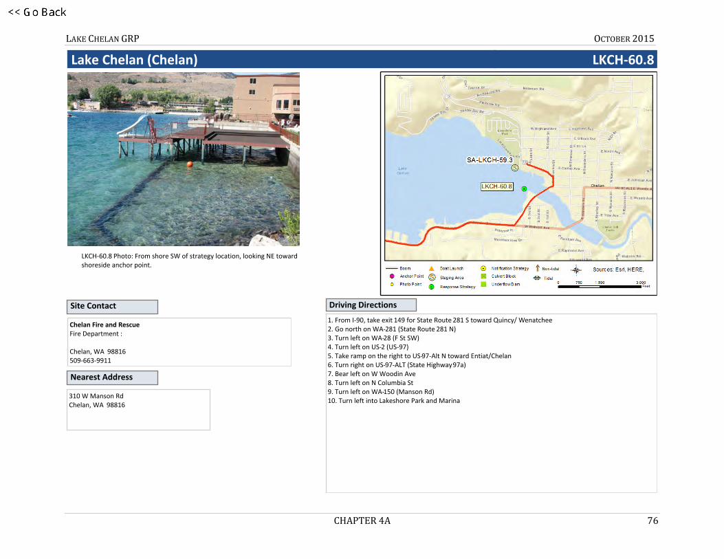
LKCH-60.8 Photo: From shore SW of strategy location, looking NE toward shoreside anchor point.
Nearest Address
Site Contact
310 W Manson RdChelan, WA 98816
Chelan Fire and RescueFire Department :
Chelan, WA 98816509-663-9911
Driving Directions
1. From I-90, take exit 149 for State Route 281 S toward Quincy/ Wenatchee 2. Go north on WA-281 (State Route 281 N)3. Turn left on WA-28 (F St SW)4. Turn left on US-2 (US-97)5. Take ramp on the right to US-97-Alt N toward Entiat/Chelan6. Turn right on US-97-ALT (State Highway 97a)7. Bear left on W Woodin Ave8. Turn left on N Columbia St9. Turn left on WA-150 (Manson Rd)10. Turn left into Lakeshore Park and Marina
LAKE CHELAN GRP OCTOBER 2015
CHAPTER 4A 77
7LKCH-60.9
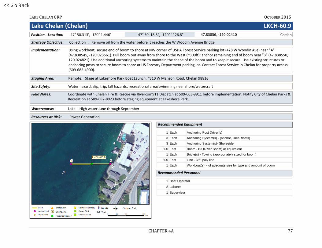
Lake Chelan (Chelan) LKCH-60.9
Site Safety: Water hazard; slip, trip, fall hazards; recreational area/swimming near shore/watercraft
Staging Area: Remote: Stage at Lakeshore Park Boat Launch, ~310 W Manson Road, Chelan 98816
Using workboat, secure end of boom to shore at NW corner of USDA Forest Service parking lot (428 W Woodin Ave) near "A" (47.838545, -120.023561). Pull boom out away from shore to the West (~300ft); anchor remaining end of boom near “B” (47.838550, 120.024821). Use additional anchoring systems to maintain the shape of the boom and to keep it secure. Use existing structures or anchoring posts to secure boom to shore at US Forestry Department parking lot. Contact Forest Service in Chelan for property access (509-682-4900).
Coordinate with Chelan Fire & Rescue via Rivercom911 Dispatch at 509-663-9911 before implementation. Notify City of Chelan Parks & Recreation at 509-682-8023 before staging equipment at Lakeshore Park.
Watercourse: Lake - High water June through September
Resources at Risk: Power Generation
Strategy Objective: Collection : Remove oil from the water before it reaches the W Woodin Avenue Bridge
Recommended Equipment
Recommended Personnel
Implementation:
Field Notes:
1 Each Anchoring Post Driver(s)
3 Each Anchoring System(s) - (anchor, lines, floats)
3 Each Anchoring System(s)- Shoreside
300 Feet Boom - B3 (River Boom) or equivalent
1 Each Bridle(s) - Towing (appropriately sized for boom)
300 Feet Line - 3/8” poly line
1 Each Workboat(s) - of adequate size for type and amount of boom
1 Boat Operator
2 Laborer
1 Supervisor
Chelan47.83856, -120.02410 47° 50' 18.8", -120° 1' 26.8" 47° 50.313', -120° 1.446' Position - Location:

LAKE CHELAN GRP OCTOBER 2015
CHAPTER 4A 78
Lake Chelan (Chelan) LKCH-60.9
LKCH-60.9 Photo: Aerial photo of strategy location
Nearest Address
Site Contact
310 W Manson RoadChelan, WA 98816
USDA Forest Service ChelanLand/Property Owner :
Chelan, WA 98816509-682-4900
Driving Directions
1. From I-90, take exit 149 for State Route 281 S toward Quincy/ Wenatchee 2. Go north on WA-281 (State Route 281 N)3. Turn left on WA-28 (F St SW)4. Turn left on US-2 (US-97)5. Take ramp on the right to US-97-Alt N toward Entiat/Chelan6. Turn right on US-97-ALT (State Highway 97a)7. Bear left on W Woodin Ave8. Turn left on N Columbia St9. Turn left on WA-150 (Manson Rd)10. Turn left into Lakeshore Park and Marina
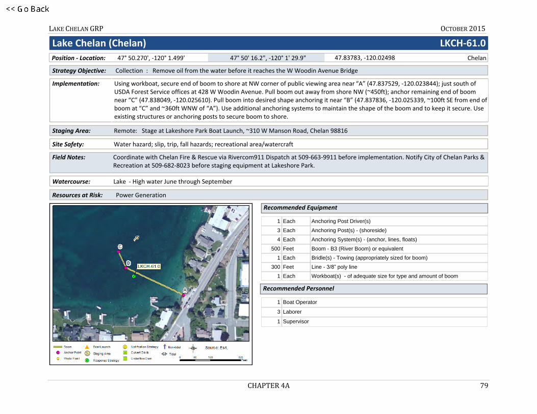
LAKE CHELAN GRP OCTOBER 2015
CHAPTER 4A 79
8LKCH-61.0
Lake Chelan (Chelan) LKCH-61.0
Site Safety: Water hazard; slip, trip, fall hazards; recreational area/watercraft
Staging Area: Remote: Stage at Lakeshore Park Boat Launch, ~310 W Manson Road, Chelan 98816
Using workboat, secure end of boom to shore at NW corner of public viewing area near “A” (47.837529, -120.023844); just south of USDA Forest Service offices at 428 W Woodin Avenue. Pull boom out away from shore NW (~450ft); anchor remaining end of boom near “C” (47.838049, -120.025610). Pull boom into desired shape anchoring it near “B” (47.837836, -120.025339, ~100ft SE from end of boom at “C” and ~360ft WNW of “A”). Use additional anchoring systems to maintain the shape of the boom and to keep it secure. Use existing structures or anchoring posts to secure boom to shore.
Coordinate with Chelan Fire & Rescue via Rivercom911 Dispatch at 509-663-9911 before implementation. Notify City of Chelan Parks & Recreation at 509-682-8023 before staging equipment at Lakeshore Park.
Watercourse: Lake - High water June through September
Resources at Risk: Power Generation
Strategy Objective: Collection : Remove oil from the water before it reaches the W Woodin Avenue Bridge
Recommended Equipment
Recommended Personnel
Implementation:
Field Notes:
1 Each Anchoring Post Driver(s)
3 Each Anchoring Post(s) - (shoreside)
4 Each Anchoring System(s) - (anchor, lines, floats)
500 Feet Boom - B3 (River Boom) or equivalent
1 Each Bridle(s) - Towing (appropriately sized for boom)
300 Feet Line - 3/8” poly line
1 Each Workboat(s) - of adequate size for type and amount of boom
1 Boat Operator
3 Laborer
1 Supervisor
Chelan47.83783, -120.02498 47° 50' 16.2", -120° 1' 29.9" 47° 50.270', -120° 1.499' Position - Location:
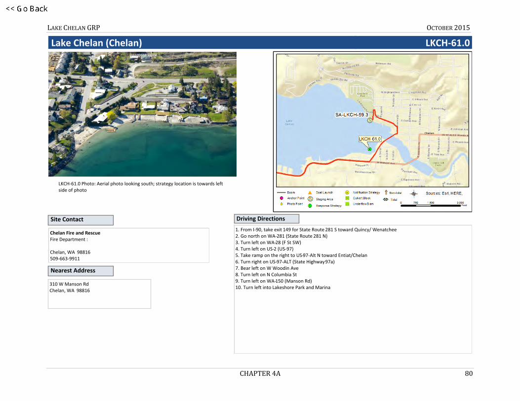
LAKE CHELAN GRP OCTOBER 2015
CHAPTER 4A 80
Lake Chelan (Chelan) LKCH-61.0
LKCH-61.0 Photo: Aerial photo looking south; strategy location is towards left side of photo
Nearest Address
Site Contact
310 W Manson RdChelan, WA 98816
Chelan Fire and RescueFire Department :
Chelan, WA 98816509-663-9911
Driving Directions
1. From I-90, take exit 149 for State Route 281 S toward Quincy/ Wenatchee 2. Go north on WA-281 (State Route 281 N)3. Turn left on WA-28 (F St SW)4. Turn left on US-2 (US-97)5. Take ramp on the right to US-97-Alt N toward Entiat/Chelan6. Turn right on US-97-ALT (State Highway 97a)7. Bear left on W Woodin Ave8. Turn left on N Columbia St9. Turn left on WA-150 (Manson Rd)10. Turn left into Lakeshore Park and Marina

LAKE CHELAN GRP OCTOBER 2015
CHAPTER 4A 81
9LKCH-61.2
Lake Chelan (Chelan) LKCH-61.2
Site Safety: Water hazard; slip, trip, fall hazards; recreational area/watercraft
Staging Area: Remote: Stage at Lakeshore Park Boat Launch, ~310 W Manson Road, Chelan 98816
Using workboat, secure end of boom to shore at NW corner of the Peterson’s Waterfront Resort property on the west side of the west-end dock near “A” (47.837350, -120.028760). Pull boom out away from shore NW (~265ft); anchor remaining end of boom near “C” (47.837945, -120.029356). Pull boom into desired shape anchoring it near “B” (47.837781, 120.028973, about 120ft out from west-end dock, ~110ft SE of “C” and ~170ft NNW of “A”). Use additional anchoring systems to maintain the shape of the boom and to keep it secure. Use existing structures or posts to secure boom at “A".
Coordinate with Chelan Fire & Rescue via Rivercom911 Dispatch at 509-663-9911 before implementation. Notify City of Chelan Parks & Recreation at 509-682-8023 before staging equipment at Lakeshore Park.
Watercourse: Lake - High water June through September
Resources at Risk: Power Generation
Strategy Objective: Collection : Remove oil from the water before it reaches the W Woodin Avenue Bridge
Recommended Equipment
Recommended Personnel
Implementation:
Field Notes:
1 Each Anchoring Post Driver(s)
3 Each Anchoring Post(s) - (shoreside)
3 Each Anchoring System(s) - (anchor, lines, floats)
300 Feet Boom - B3 (River Boom) or equivalent
1 Each Bridle(s) - Towing (appropriately sized for boom)
300 Feet Line - 3/8” poly line
1 Each Workboat(s) - of adequate size for type and amount of boom
1 Boat Operator
2 Laborer
1 Supervisor
Chelan47.83735, -120.02880 47° 50' 14.4", -120° 1' 43.7" 47° 50.241', -120° 1.728' Position - Location:
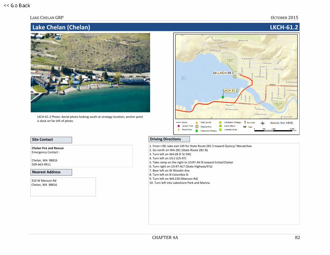
LAKE CHELAN GRP OCTOBER 2015
CHAPTER 4A 82
Lake Chelan (Chelan) LKCH-61.2
LKCH-61.2 Photo: Aerial photo looking south at strategy location; anchor point is dock on far left of photo.
Nearest Address
Site Contact
310 W Manson RdChelan, WA 98816
Chelan Fire and RescueEmergency Contact :
Chelan, WA 98816509-663-9911
Driving Directions
1. From I-90, take exit 149 for State Route 281 S toward Quincy/ Wenatchee 2. Go north on WA-281 (State Route 281 N)3. Turn left on WA-28 (F St SW)4. Turn left on US-2 (US-97)5. Take ramp on the right to US-97-Alt N toward Entiat/Chelan6. Turn right on US-97-ALT (State Highway 97a)7. Bear left on W Woodin Ave8. Turn left on N Columbia St9. Turn left on WA-150 (Manson Rd)10. Turn left into Lakeshore Park and Marina

LAKE CHELAN GRP OCTOBER 2015
CHAPTER 4A 83
10LKCH-104.4
Lake Chelan LKCH-104.4
Site Safety: Steep banks; rocky hillside; water hazard; slip, trip, fall hazards; limited or no site access
Staging Area: Remote: Coordinate with incident command (or call Ecology) before staging in Chelan at SA-LKCH-61.5 Mountain Barge.
Using workboat, secure end of boom to shore near “A” (48.171002, -120.545235). Pull boom out away from shore and then North (250ft); secure remaining boom end to shore near “C” (48.171454, -120.544855). Pull boom into desired shape anchoring it near “B” (48.170992, -120.545039, about ~50ft east of “A”). Boom standoff distance from shore should be 15ft to 20ft. It is very rocky and steep at this location. Shoreside anchoring posts may not be effective and safe shoreside access is not available. Water depth is very deep immediately offshore.
Coordinate transit to strategy location with incident/unified command or call Ecology (509-575-2490). Nearest boat ramp (lake above 1093' only) is BL-LKCH-82.6 (~20 mi S). In low water use BL-LKCH-71.4 (~30 mi S).
Watercourse: Lake - High water June through September
Resources at Risk: Sensitive Resources
Strategy Objective: Exclusion : Keep oil away from shore at this location during periods of High Lake Level Only
Recommended Equipment
Recommended Personnel
Implementation:
Field Notes:
1 Each Anchoring Post Driver(s)
6 Each Anchoring Post(s) - (shoreside)
4 Each Anchoring System(s) - (anchor, lines, floats)
250 Feet Boom - B3 (River Boom) or equivalent
1 Each Bridle(s) - Towing (appropriately sized for boom)
1 Each Heaving Line(s)
500 Feet Line - 3/8” poly line
1 Each Workboat(s) - of adequate size for type and amount of boom
1 Boat Operator
2 Laborer
1 Supervisor
Chelan48.17123, -120.54483 48° 10' 16.4", -120° 32' 41.4" 48° 10.274', -120° 32.690' Position - Location:

LAKE CHELAN GRP OCTOBER 2015
CHAPTER 4A 84
Lake Chelan LKCH-104.4
LKCH-104.4 Photo: On Lake Chelan near strategy location looking west towards shore.
Nearest Address
Site Contact
Chelan, WA 98816
Mountain Barge ServicesPrimary Contact : 509-682-2493
U.S. Forest Service Okanogan-Wenatchee National ForestLand/Property Owner : 509-664-9254
Driving Directions
1. From I-90, take exit 149 for State Route 281 S toward Quincy/ Wenatchee 2. Go north on WA-281 (State Route 281 N)3. Turn left on WA-28 (F St SW)4. Turn left on US-2 (US-97)5. Take ramp on the right to US-97-Alt N toward Entiat/Chelan6. Turn right on US-97-ALT (State Highway 97a)7. Finish at 1222 W Woodin Avenue, 98816, on the left
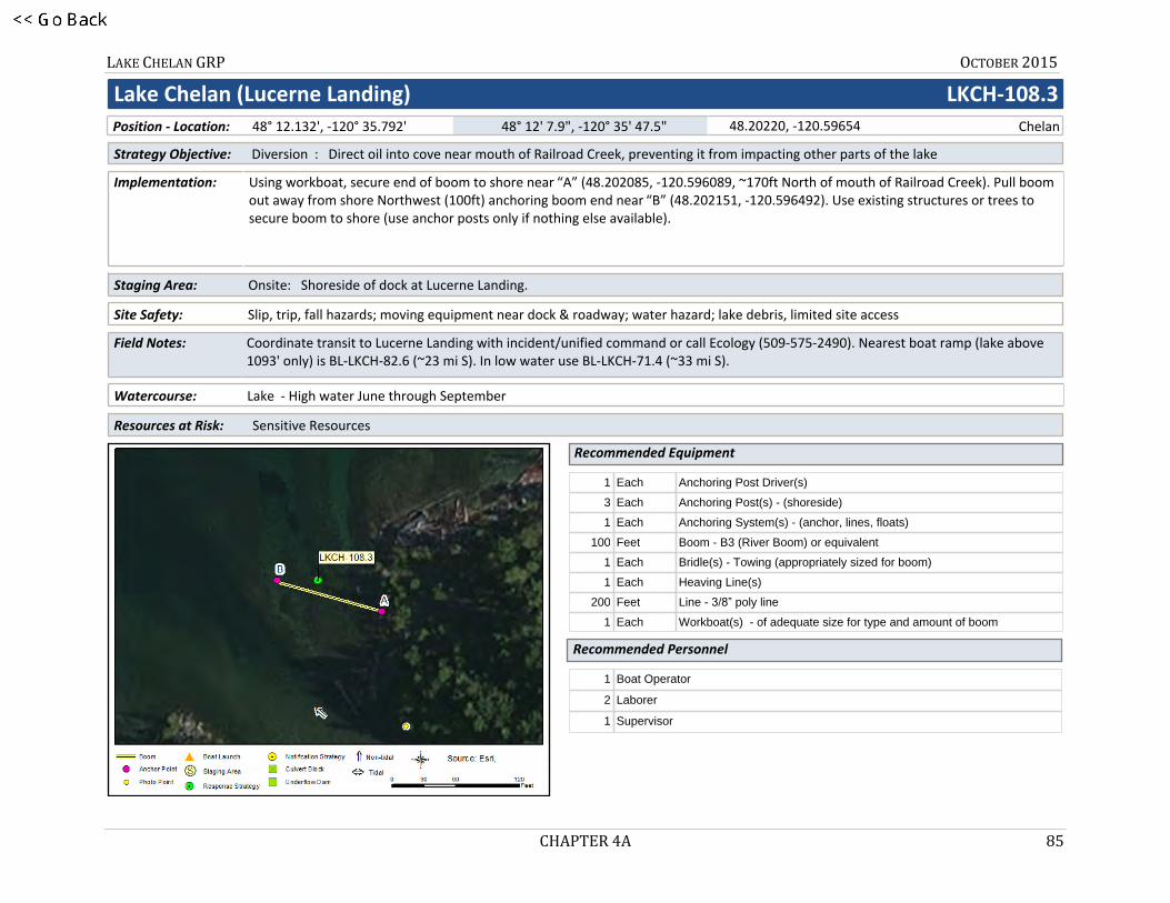
LAKE CHELAN GRP OCTOBER 2015
CHAPTER 4A 85
11LKCH-108.3
Lake Chelan (Lucerne Landing) LKCH-108.3
Site Safety: Slip, trip, fall hazards; moving equipment near dock & roadway; water hazard; lake debris, limited site access
Staging Area: Onsite: Shoreside of dock at Lucerne Landing.
Using workboat, secure end of boom to shore near “A” (48.202085, -120.596089, ~170ft North of mouth of Railroad Creek). Pull boom out away from shore Northwest (100ft) anchoring boom end near “B” (48.202151, -120.596492). Use existing structures or trees to secure boom to shore (use anchor posts only if nothing else available).
Coordinate transit to Lucerne Landing with incident/unified command or call Ecology (509-575-2490). Nearest boat ramp (lake above 1093' only) is BL-LKCH-82.6 (~23 mi S). In low water use BL-LKCH-71.4 (~33 mi S).
Watercourse: Lake - High water June through September
Resources at Risk: Sensitive Resources
Strategy Objective: Diversion : Direct oil into cove near mouth of Railroad Creek, preventing it from impacting other parts of the lake
Recommended Equipment
Recommended Personnel
Implementation:
Field Notes:
1 Each Anchoring Post Driver(s)
3 Each Anchoring Post(s) - (shoreside)
1 Each Anchoring System(s) - (anchor, lines, floats)
100 Feet Boom - B3 (River Boom) or equivalent
1 Each Bridle(s) - Towing (appropriately sized for boom)
1 Each Heaving Line(s)
200 Feet Line - 3/8” poly line
1 Each Workboat(s) - of adequate size for type and amount of boom
1 Boat Operator
2 Laborer
1 Supervisor
Chelan48.20220, -120.59654 48° 12' 7.9", -120° 35' 47.5" 48° 12.132', -120° 35.792' Position - Location:

LAKE CHELAN GRP OCTOBER 2015
CHAPTER 4A 86
Lake Chelan (Lucerne Landing) LKCH-108.3
LKCH-108.3 Photo: On Lake Chelan near Lucerne Landing looking SE towards mouth of Railroad Creek.
Nearest Address
Site Contact
Chelan, WA 98816
Mountain Barge ServicesPrimary Contact : 509-682-2493
U.S. Forest Service Okanogan-Wenatchee National ForestLand/Property Owner : 509-664-9254
Driving Directions
1. From I-90, take exit 149 for State Route 281 S toward Quincy/ Wenatchee 2. Go north on WA-281 (State Route 281 N)3. Turn left on WA-28 (F St SW)4. Turn left on US-2 (US-97)5. Take ramp on the right to US-97-Alt N toward Entiat/Chelan6. Turn right on US-97-ALT (State Highway 97a)7. Finish at 1222 W Woodin Avenue, 98816, on the left

LAKE CHELAN GRP OCTOBER 2015
CHAPTER 4A 87
12LKCH-108.4
Lake Chelan (Lucerne Landing) LKCH-108.4
Site Safety: Slippery banks when wet or icy; trip & fall hazards; moving equipment on dock & roadway; water hazard; lake debris
Staging Area: Onsite: Shoreside of dock at Lucerne Landing.
Using workboat, secure end of boom to “A” (far end of the dock at Lucerne Landing). Pull boom out away from the dock to the Southeast (~450ft); secure remaining boom end to shore near “B” (48.201430, -120.597200, ~450ft SE of dock’s far end, ~250ft NE from base of dock’s SE corner). Use additional anchoring systems to maintain the shape of the boom and to keep it secure. Use existing structures or trees to secure boom to shore (use anchor posts only if nothing else available).
Coordinate transit to Lucerne Landing with incident/unified command or call Ecology (509-575-2490). Nearest boat ramp (lake above 1093' only) is BL-LKCH-82.6 (~23 mi S). In low water use BL-LKCH-71.4 (~33 mi S).
Watercourse: Lake - High water June through September
Resources at Risk: Sensitive Resources
Strategy Objective: Containment : Prevent oil from escaping the dock area at Lucerne Landing
Recommended Equipment
Recommended Personnel
Implementation:
Field Notes:
1 Each Anchoring Post Driver(s)
3 Each Anchoring Post(s) - (shoreside)
1 Each Anchoring System(s) - (anchor, lines, floats)
500 Feet Boom - B3 (River Boom) or equivalent
1 Each Bridle(s) - Towing (appropriately sized for boom)
1 Each Heaving Line(s)
300 Feet Line - 3/8” poly line
1 Each Workboat(s) - of adequate size for type and amount of boom
1 Boat Operator
3 Laborer
1 Supervisor
Chelan48.20166, -120.59835 48° 12' 6.0", -120° 35' 54.1" 48° 12.099', -120° 35.901' Position - Location:

LAKE CHELAN GRP OCTOBER 2015
CHAPTER 4A 88
Lake Chelan (Lucerne Landing) LKCH-108.4
LKCH-108.4 Photo: Shoreside of SW corner of dock at Lucerne Landing, looking NW out towards Lake Chelan.
Nearest Address
Site Contact
Chelan, WA 98816
Mountain Barge ServicesLand/Property Owner : 509-682-2493
Driving Directions
1. From I-90, take exit 149 for State Route 281 S toward Quincy/ Wenatchee 2. Go north on WA-281 (State Route 281 N)3. Turn left on WA-28 (F St SW)4. Turn left on US-2 (US-97)5. Take ramp on the right to US-97-Alt N toward Entiat/Chelan6. Turn right on US-97-ALT (State Highway 97a)7. Finish at 1222 W Woodin Avenue, 98816, on the left
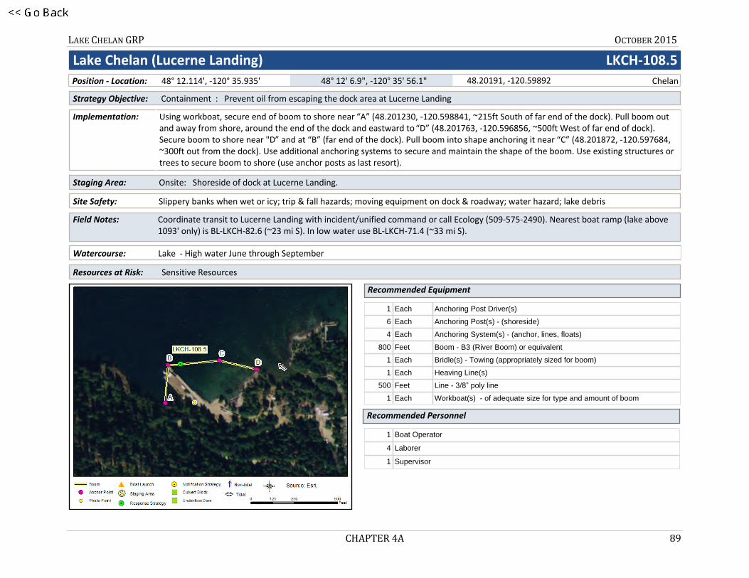
LAKE CHELAN GRP OCTOBER 2015
CHAPTER 4A 89
13LKCH-108.5
Lake Chelan (Lucerne Landing) LKCH-108.5
Site Safety: Slippery banks when wet or icy; trip & fall hazards; moving equipment on dock & roadway; water hazard; lake debris
Staging Area: Onsite: Shoreside of dock at Lucerne Landing.
Using workboat, secure end of boom to shore near “A” (48.201230, -120.598841, ~215ft South of far end of the dock). Pull boom out and away from shore, around the end of the dock and eastward to “D” (48.201763, -120.596856, ~500ft West of far end of dock). Secure boom to shore near "D” and at “B” (far end of the dock). Pull boom into shape anchoring it near “C” (48.201872, -120.597684, ~300ft out from the dock). Use additional anchoring systems to secure and maintain the shape of the boom. Use existing structures or trees to secure boom to shore (use anchor posts as last resort).
Coordinate transit to Lucerne Landing with incident/unified command or call Ecology (509-575-2490). Nearest boat ramp (lake above 1093' only) is BL-LKCH-82.6 (~23 mi S). In low water use BL-LKCH-71.4 (~33 mi S).
Watercourse: Lake - High water June through September
Resources at Risk: Sensitive Resources
Strategy Objective: Containment : Prevent oil from escaping the dock area at Lucerne Landing
Recommended Equipment
Recommended Personnel
Implementation:
Field Notes:
1 Each Anchoring Post Driver(s)
6 Each Anchoring Post(s) - (shoreside)
4 Each Anchoring System(s) - (anchor, lines, floats)
800 Feet Boom - B3 (River Boom) or equivalent
1 Each Bridle(s) - Towing (appropriately sized for boom)
1 Each Heaving Line(s)
500 Feet Line - 3/8” poly line
1 Each Workboat(s) - of adequate size for type and amount of boom
1 Boat Operator
4 Laborer
1 Supervisor
Chelan48.20191, -120.59892 48° 12' 6.9", -120° 35' 56.1" 48° 12.114', -120° 35.935' Position - Location:

LAKE CHELAN GRP OCTOBER 2015
CHAPTER 4A 90
Lake Chelan (Lucerne Landing) LKCH-108.5
LKCH-108.5 Photo: Shoreside of SW corner of dock at Lucerne Landing, looking NW out towards Lake Chelan.
Nearest Address
Site Contact
Chelan, WA 98816
Mountain Barge ServicesPrimary Contact : 509-682-2493
U.S. Forest Service Okanogan-Wenatchee National ForestLand/Property Owner : 509-664-9254
Driving Directions
1. From I-90, take exit 149 for State Route 281 S toward Quincy/ Wenatchee 2. Go north on WA-281 (State Route 281 N)3. Turn left on WA-28 (F St SW)4. Turn left on US-2 (US-97)5. Take ramp on the right to US-97-Alt N toward Entiat/Chelan6. Turn right on US-97-ALT (State Highway 97a)7. Finish at 1222 W Woodin Avenue, 98816, on the left

LAKE CHELAN GRP OCTOBER 2015
CHAPTER 4B 91
x83
APPENDIX 4B
Notification Strategy 2-Pagers

LAKE CHELAN GRP OCTOBER 2015
CHAPTER 4B 92
NOTIFICATION STRATEGIES – LIST
LKCH-2.8-N LKCH-47.5-N LKCH-60.1-N LKCH-60.2-N

LAKE CHELAN GRP OCTOBER 2015
CHAPTER 4B 93
14LKCH-2.8-N
National Park Service Stehekin Ranger Station LKCH-2.8-N
Call the NPS Stehekin Ranger's Station at (509) 699-2080 x 29 (24-hr number).
Park Service has 26' boat, boom and access to gravel launch at Stehekin.
Watercourse: Lake - Lake Chelan
Resources at Risk: : Federal Lands, Marina, Public Recreation Site/Area, Wetlands
Strategy Objective: Notification : Notify park staff of oil spill so they can deploy response equipment.
Communication Process and Action:
Implementation:
Field Notes:
Call the National Park Service and explain the situation regarding the spill. Advise they consider deploying spill response equipment where appropriate.
Call the following numbers, in order, until someone at NPS is reached:
Stehekin District Ranger Office: (509) 699-2080 x 12 (8 am - 5 pm)(509) 699-2080 x 29 (24/7)
National Recreation Area Communication Center:(360) 854-7249
Position - Location: 48° 18.503', -120° 39.386' 48° 18' 30.2", -120° 39' 23.2" Chelan48.30838, -120.65643

LAKE CHELAN GRP OCTOBER 2015
CHAPTER 4B 94
National Park Service Stehekin Ranger Station LKCH-2.8-N
LKCH-2.8-N Photo: No photograph available.
Nearest Address
Site Contact
1222 W Woodin AveChelan, WA 98816
National Park ServiceEmergency Contact : Stehekin District Ranger Office
Stehekin, WA509-699-2080 ext. 29 or 12
Driving Directions
Stehekin is accessible only by plane, boat or ferry. Directions to Mountain Barge Services dock: 1. From I-90 in George, Washington take exit 149 towards Quincy/Wenatchee (0.27 miles)2. Turn left on WA-281 (Royal Anne Ave) (10.56 miles)3. Turn left on WA-28 (F St SW) (33.79 miles)4. Turn left on US-2 (US-97) (1.02 miles)5. Take ramp on the right to US-97-Alt N toward Entiat/Chelan (0.24 miles)6. Turn right on US-97-ALT (State Highway 97a) (32.7 miles)7. Turn left into Mountain Barge Services, 1222 W Woodin Ave 98816.At Stehekin Landing, the Golden West Visitor's Center is across the street, or southeast at the end of Stehekin Valley Road.

LAKE CHELAN GRP OCTOBER 2015
CHAPTER 4B 95
15LKCH-47.5-N
Lake Chelan Reclamation District Water Intake LKCH-47.5-N
Call Lake Chelan Notification District emergency line at 509-687-3548. Inform them that a spill has occurred and to consider shutting down their intakes.
Two drinking water intakes at 47.5 and 49.5 (Manson Bay). Irrigation intake located at Old Mill Park.
Watercourse: Lake - Lake Chelan
Resources at Risk: : Public Health and Safety, Water Intakes
Strategy Objective: Notification : Shut down drinking water and irrigation intakes.
Communication Process and Action:
Implementation:
Field Notes:
Call the Lake Chelan Reclamation District and explain the situation regarding the spill. Recommend they consider shutting down their water intakes.
Call the following numbers in order until someone at LCRD is reached: 509-687-3548 (24/7 Emergency Line)509-470-1960 (Water Treatment Plant Operator in Charge)509-679-0639 (Manager)
Position - Location: 47° 53.986', -120° 11.544' 47° 53' 59.2", -120° 11' 32.7" Manson47.89977, -120.19240

LAKE CHELAN GRP OCTOBER 2015
CHAPTER 4B 96
Lake Chelan Reclamation District Water Intake LKCH-47.5-N
LKCH-47.5-N Photo: Approximate location of northernmost drinking water intake of Lake Chelan Reclamation District.
Nearest Address
Site Contact
80 Wapato WayManson, WA 98831
Lake Chelan Reclamation DistrictEmergency Contact : Utility80 Wapato WayManson, WA 98831509-687-3548
Driving Directions
1. From I-90 in George, Washington take exit 149 towards Quincy/Wenatchee (0.27 miles)2. Turn left on WA-281 (Royal Anne Ave) (10.56 miles)3. Turn left on WA-28 (F St SW) (33.79 miles)4. Turn left on US-2 (US-97) (1.02 miles)5. Take ramp on the right to US-97-Alt N toward Entiat/Chelan (0.24 miles)6. Turn right on US-97-ALT (State Highway 97a) (33.74 miles)7. Bear left on W Woodin Ave (0.39 miles)8. Turn left on N Columbia St (0.07 miles)9. Turn left on WA-150 (Manson Rd) (7.6 miles)10. Continue on Wapato Way (0.16 miles)11. Finish at 80 Wapato Way, 98831
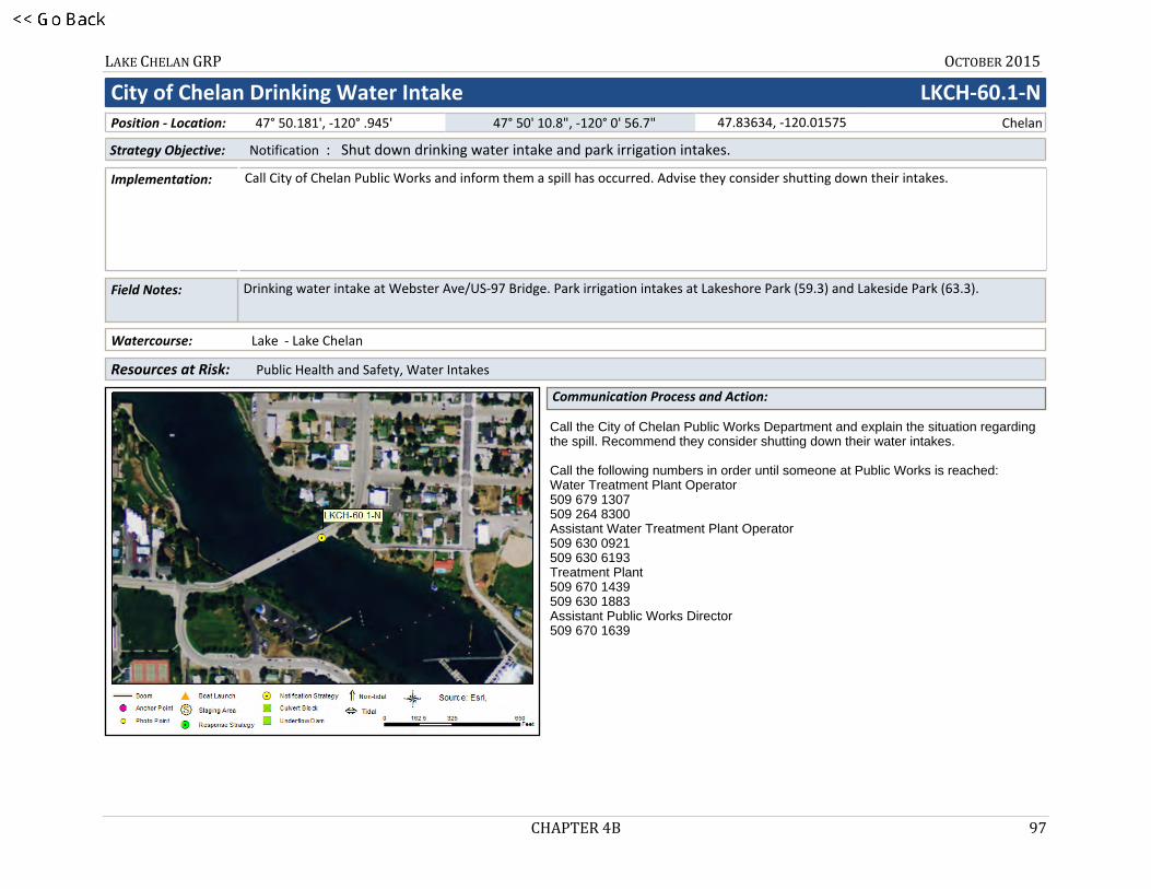
LAKE CHELAN GRP OCTOBER 2015
CHAPTER 4B 97
16LKCH-60.1-N
City of Chelan Drinking Water Intake LKCH-60.1-N
Call City of Chelan Public Works and inform them a spill has occurred. Advise they consider shutting down their intakes.
Drinking water intake at Webster Ave/US-97 Bridge. Park irrigation intakes at Lakeshore Park (59.3) and Lakeside Park (63.3).
Watercourse: Lake - Lake Chelan
Resources at Risk: : Public Health and Safety, Water Intakes
Strategy Objective: Notification : Shut down drinking water intake and park irrigation intakes.
Communication Process and Action:
Implementation:
Field Notes:
Call the City of Chelan Public Works Department and explain the situation regarding the spill. Recommend they consider shutting down their water intakes.
Call the following numbers in order until someone at Public Works is reached:Water Treatment Plant Operator509 679 1307509 264 8300Assistant Water Treatment Plant Operator509 630 0921509 630 6193Treatment Plant 509 670 1439509 630 1883Assistant Public Works Director509 670 1639
Position - Location: 47° 50.181', -120° .945' 47° 50' 10.8", -120° 0' 56.7" Chelan47.83634, -120.01575

LAKE CHELAN GRP OCTOBER 2015
CHAPTER 4B 98
City of Chelan Drinking Water Intake LKCH-60.1-N
LKCH-60.1-N Photo: Aerial photo of approximate location of northernmost water intake.
Nearest Address
Site Contact
509 S Washington StChelan, WA 98816
Chelan Public Works - Water DivisionMunicipality (County/City) : City Utility50 Chelan Falls HwyChelan, WA 98816509-682-8030
Driving Directions
1. From I-90 in George, Washington take exit 149.2. At exit 149 take ramp on the right to WA-281 N toward Quincy/Wenatchee (0.27 miles)3. Turn left on WA-281 (Royal Anne Ave) (10.56 miles)4. Turn left on WA-28 (F St SW) (33.79 miles)5. Continue on US-2 (Sunset Hwy) (11.93 miles)6. At fork keep left on US-97 (State Highway 97) (22.08 miles)7. Turn left on WA-150 (Highway 150) (2.98 miles)8. Turn left at US-97-ALT to stay on WA-150 (E Woodin Ave) (0.33 miles)9. Turn left on S Clifford St (0.07 miles)10. Turn left on E Wapato Ave (0.07 miles)11. Turn right on S Washington St (0.06 miles)12. Finish at 509 S Washington St, 98816

LAKE CHELAN GRP OCTOBER 2015
CHAPTER 4B 99
17LKCH-60.2-N
Lake Chelan Hydroelectric Project LKCH-60.2-N
Call System Operations at 509/661-4000 (staffed 24/7). They will deploy response equipment and/or adjust water intakes.
Watercourse: River - Above a Dam - Chelan River - high flow June-Sept
Resources at Risk: : Power Generation, Salmon Bearing Stream
Strategy Objective: Notification : Keep oil out of dam
Communication Process and Action:
Implementation:
Field Notes:
Call System Operations at 509/661-4000 (staffed 24/7). Chelan County PUD has a trailer of spill response equipment staged within 50 miles of the Lake Chelan Dam. When notified they will deploy response equipment to protect the dam infrastructure. Water intakes are subsurface but their flow could be reduced or shut off in an emergency.
Position - Location: 47° 50.068', -120° .748' 47° 50' 4.1", -120° 0' 44.9" Chelan47.83447, -120.01246

LAKE CHELAN GRP OCTOBER 2015
CHAPTER 4B 100
Lake Chelan Hydroelectric Project LKCH-60.2-N
LKCH-60.2-N Photo: Aerial photo looking NE at Lake Chelan Dam
Nearest Address
Site Contact
Chiari Falls RoadChelan, WA 98816
City of Chelan Parks and RecreationPrimary Contact : Owner
Chelan, WA 98816509-682-8023
Driving Directions
1. From I-90 in George, WA take exit 149 for State Route 281 toward Quincy/ Wenatchee2. Go north on WA-281 (State Route 281 N)3. Turn left on WA-28 (F St SW)4. Turn left on US-2 (US-97)5. Take ramp on the right to US-97-Alt N toward Entiat/Chelan6. Turn right on US-97-ALT (State Highway 97a)7. Turn right on E Farnham Ave8. Bear right on S Saunders St9. Turn left on E Iowa St10. Continue on E Iowa Ave11. Turn left on Chiari Falls Rd12. Finish at Chiari Falls Road, 98816, on the left
LAKE CHELAN GRP OCTOBER 2015
APPENDIX 4C 101
y93
APPENDIX 4C
Staging Area 2-Pagers

LAKE CHELAN GRP OCTOBER 2015
APPENDIX 4C 102
STAGING AREAS – LIST
SA-LKCH-59.3 SA-LKCH-61.5 SA-LKCH-71.4

LAKE CHELAN GRP OCTOBER 2015
APPENDIX 4C 103
18SA-LKCH-59.3
GRP Response Strategies Served:
LKCH-60.9, LKCH-58.9, LKCH-61.0, LKCH-61.2, LKCH-60.6, LKCH-60.8
Lakeshore Park Marina SA-LKCH-59.3
Pump-out station, launch and ample pay parking. Adjacent to RV Park with utilities and wi-fi.
Location Information
Comments:
Staging Area
Asset Type/Status Amount/Number
Boat Dock(s) Yes 100 Slips
Boat Ramp(s) Concrete, Solid 1
Cell Phone Coverage Unknown
Covered Spaces Yes 2 Picnic shelters in park
Estimated Lot Size 45000 Square Feet
Lot Cover (Primary) Asphalt 100 %
Parking - Car Marked 102 $5 Fee
Parking - Trailer Marked 24 $5 Fee
Power Yes
Restroom Restroom - with Showers
User Fee Yes 8 $ Launch Fee (Moorage varies)
Waste Disposal Pumpout 2
Water (potable) Yes
47° 50.507', -120° 1.463' Position - Location: 47° 50' 30.4", -120° 1' 27.8" 47.84179, -120.02438 Chelan

LAKE CHELAN GRP OCTOBER 2015
APPENDIX 4C 104
Lakeshore Park Marina SA-LKCH-59.3
SA-LKCH-59.3 Photo: Aerial photo looking NE at Lakeshore Park Boat Launch
Nearest Address
Site Contact
310 W Manson RoadChelan, WA 98816
City of Chelan Parks and RecreationMunicipality (County/City) : Owner
Chelan, WA 98816509-682-8023
Driving Directions
1. From I-90, take exit 149 for State Route 281 S toward Quincy/ Wenatchee 2. Go north on WA-281 (State Route 281 N)3. Turn left on WA-28 (F St SW)4. Turn left on US-2 (US-97)5. Take ramp on the right to US-97-Alt N toward Entiat/Chelan6. Turn right on US-97-ALT (State Highway 97a)7. Bear left on W Woodin Ave8. Turn left on N Columbia St9. Turn left on WA-150 (Manson Rd)10. Turn left into Lakeshore Park and Marina

LAKE CHELAN GRP OCTOBER 2015
APPENDIX 4C 105
19SA-LKCH-61.5
GRP Response Strategies Served:
LKCH-37.0, LKCH-37.5
Mountain Barge Services SA-LKCH-61.5
(Previously Tom Courtney Tug & Barge). Barge to Lucerne Landing loading and departure site. Response will be coordinated from here.
Location Information
Comments:
Staging Area
Asset Type/Status Amount/Number
Boat Dock(s) Yes At Marina
Boat Ramp(s) Concrete, Plank 1
Cell Phone Coverage Unknown
Covered Spaces Yes 2 Picnic shelters at marina
Lot Cover (Primary) Asphalt 100 %
Parking - Car Marked 6 Onsite - more in marina
Parking - Trailer None Some in area
Power Yes
Restroom Restroom - with Showers At Marina
User Fee Unknown
Waste Disposal Pumpout At Marina
Water (potable) Yes
47° 50.164', -120° 2.056' Position - Location: 47° 50' 9.8", -120° 2' 3.4" 47.83607, -120.03427 Chelan

LAKE CHELAN GRP OCTOBER 2015
APPENDIX 4C 106
Mountain Barge Services SA-LKCH-61.5
SA-LKCH-61.5 Photo: Aerial photo looking S at tug and barge dock in low water (mid-April). Marina with facilities to the right.
Nearest Address
Site Contact
1228 W Woodin AveChelan, WA 98816
Mountain Barge ServicesLand/Property Owner :
Chelan, WA 98816509-682-2493
Driving Directions
1. From I-90, take exit 149 for State Route 281 S toward Quincy/ Wenatchee 2. Go north on WA-281 (State Route 281 N)3. Turn left on WA-28 (F St SW)4. Turn left on US-2 (US-97)5. Take ramp on the right to US-97-Alt N toward Entiat/Chelan6. Turn right on US-97-ALT (State Highway 97a)7. Finish at 1222 W Woodin Avenue, 98816, on the left

LAKE CHELAN GRP OCTOBER 2015
APPENDIX 4C 107
20SA-LKCH-71.4
GRP Response Strategies Served:
LKCH-48.0
Lake Chelan State Park SA-LKCH-71.4
The park provides one kitchen shelter without electricity plus a small parking area.
Location Information
Comments:
Staging Area
Asset Type/Status Amount/Number
Boat Dock(s) Yes 1080 feet along 4 piers
Boat Ramp(s) Concrete, Solid 2 (double lane)
Cell Phone Coverage Unknown
Covered Spaces Yes 1 Kitchen shelter + concession stand
Lot Cover (Primary) Asphalt 28000 Square Feet
Parking - Car Marked
Parking - Trailer Marked 32
Power Yes At campsites
Restroom Restroom - with Showers 5 At campsites
User Fee No
Waste Disposal Dump Station 1
Water (potable) Yes At campsites
47° 52.527', -120° 11.814' Position - Location: 47° 52' 31.6", -120° 11' 48.9" 47.87544, -120.19691 Chelan
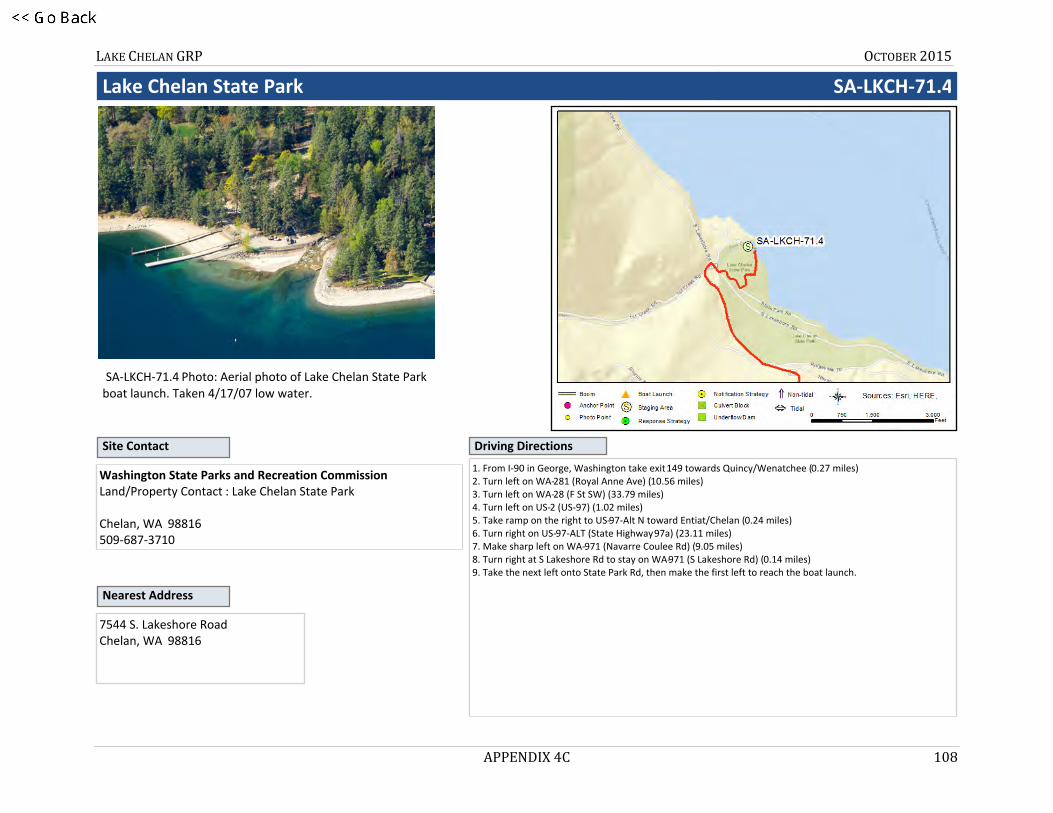
LAKE CHELAN GRP OCTOBER 2015
APPENDIX 4C 108
Lake Chelan State Park SA-LKCH-71.4
SA-LKCH-71.4 Photo: Aerial photo of Lake Chelan State Park boat launch. Taken 4/17/07 low water.
Nearest Address
Site Contact
7544 S. Lakeshore RoadChelan, WA 98816
Washington State Parks and Recreation CommissionLand/Property Contact : Lake Chelan State Park
Chelan, WA 98816509-687-3710
Driving Directions
1. From I-90 in George, Washington take exit 149 towards Quincy/Wenatchee (0.27 miles)2. Turn left on WA-281 (Royal Anne Ave) (10.56 miles)3. Turn left on WA-28 (F St SW) (33.79 miles)4. Turn left on US-2 (US-97) (1.02 miles)5. Take ramp on the right to US-97-Alt N toward Entiat/Chelan (0.24 miles)6. Turn right on US-97-ALT (State Highway 97a) (23.11 miles)7. Make sharp left on WA-971 (Navarre Coulee Rd) (9.05 miles)8. Turn right at S Lakeshore Rd to stay on WA-971 (S Lakeshore Rd) (0.14 miles)9. Take the next left onto State Park Rd, then make the first left to reach the boat launch.

LAKE CHELAN GRP OCTOBER 2015
APPENDIX 4D 109
z101
APPENDIX 4D
Boat Launch 2-Pagers

LAKE CHELAN GRP OCTOBER 2015
APPENDIX 4D 110
BOAT LAUNCHES – LIST
BL-LKCH-59.3 BL-LKCH-71.4 BL-LKCH-82.6

LAKE CHELAN GRP OCTOBER 2015
APPENDIX 4D 111
21BL-LKCH-59.3
GRP Response Strategies Served:
LKCH-60.9, LKCH-58.9, LKCH-61.0, LKCH-61.2, LKCH-60.6, LKCH-60.8
Lakeshore Park Marina BL-LKCH-59.3
Pump-out station, launch and ample pay parking. Adjacent to RV Park with utilities and wi-fi.
Location Information
Comments:
Boat Launch Location
Asset Type/Status Amount/NumberBoat Dock(s) Yes 100 Slips
Boat Ramp(s) Concrete, Solid 1
Cell Phone Coverage Unknown
Covered Spaces Yes 2 Picnic shelters in park
Estimated Lot Size 45000 Square Feet
Lot Cover (Primary) Asphalt 100 %
Parking - Car Marked 102 $5 Fee
Parking - Trailer Marked 24 $5 Fee
Power Yes
Restroom Restroom - with Showers
User Fee Yes 8 $ Launch Fee (Moorage varies)
Waste Disposal Pumpout 2
Water (potable) Yes
Chelan47.84179, -120.02438 47° 50' 30.4", -120° 1' 27.8" 47° 50.507', -120° 1.463' Position - Location:

LAKE CHELAN GRP OCTOBER 2015
APPENDIX 4D 112
Lakeshore Park Marina BL-LKCH-59.3
SA-LKCH-59.3 Photo: Aerial photo looking NE at Lakeshore Park Boat Launch
Driving Directions
Nearest Address
Site Contact
310 W Manson RoadChelan, WA 98816
City of Chelan Parks and RecreationMunicipality (County/City) : Owner
Chelan, WA 98816509-682-8023
1. From I-90, take exit 149 for State Route 281 S toward Quincy/ Wenatchee 2. Go north on WA-281 (State Route 281 N)3. Turn left on WA-28 (F St SW)4. Turn left on US-2 (US-97)5. Take ramp on the right to US-97-Alt N toward Entiat/Chelan6. Turn right on US-97-ALT (State Highway 97a)7. Bear left on W Woodin Ave8. Turn left on N Columbia St9. Turn left on WA-150 (Manson Rd)10. Turn left into Lakeshore Park and Marina

LAKE CHELAN GRP OCTOBER 2015
APPENDIX 4D 113
22BL-LKCH-71.4
GRP Response Strategies Served:
LKCH-48.0
Lake Chelan State Park BL-LKCH-71.4
Accessible in low water. The park has a double lane boat launch with nearby parking for approximately 32 vehicles with trailers. The launch offers a 1080 feet of docking space along the four piers near the launch.
Location Information
Comments:
Boat Launch Location
Asset Type/Status Amount/NumberBoat Dock(s) Yes 1080 feet along 4 piers
Boat Ramp(s) Concrete, Solid 2 (double lane)
Cell Phone Coverage Unknown
Covered Spaces Yes 1 Kitchen shelter + concession stand
Lot Cover (Primary) Asphalt 28000 Square Feet
Parking - Car Marked
Parking - Trailer Marked 32
Power Yes At campsites
Restroom Restroom - with Showers 5 At campsites
User Fee No
Waste Disposal Dump Station 1
Water (potable) Yes At campsites
Chelan47.87544, -120.19691 47° 52' 31.6", -120° 11' 48.9" 47° 52.527', -120° 11.814' Position - Location:

LAKE CHELAN GRP OCTOBER 2015
APPENDIX 4D 114
Lake Chelan State Park BL-LKCH-71.4
SA-LKCH-71.4 Photo: Aerial photo of Lake Chelan State Park boat launch. Taken 4/17/07 low water.
Driving Directions
Nearest Address
Site Contact
7544 S. Lakeshore RoadChelan, WA 98816
Washington State Parks and Recreation CommissionLand/Property Contact : Lake Chelan State Park
Chelan, WA 98816509-687-3710
1. From I-90 in George, Washington take exit 149 towards Quincy/Wenatchee (0.27 miles)2. Turn left on WA-281 (Royal Anne Ave) (10.56 miles)3. Turn left on WA-28 (F St SW) (33.79 miles)4. Turn left on US-2 (US-97) (1.02 miles)5. Take ramp on the right to US-97-Alt N toward Entiat/Chelan (0.24 miles)6. Turn right on US-97-ALT (State Highway 97a) (23.11 miles)7. Make sharp left on WA-971 (Navarre Coulee Rd) (9.05 miles)8. Turn right at S Lakeshore Rd to stay on WA-971 (S Lakeshore Rd) (0.14 miles)9. Take the next left onto State Park Rd, then make the first left to reach the boat launch.

LAKE CHELAN GRP OCTOBER 2015
APPENDIX 4D 115
23BL-LKCH-82.6
GRP Response Strategies Served:
LKCH-108.3, LKCH-108.4, LKCH-37.0, LKCH-104.4, LKCH-37.5, LKCH-108.5
25-Mile Creek Boat Launch BL-LKCH-82.6
Twenty-Five Mile Creek State Park offers two boat ramps. The launch is usable from mid-June to the end of December, if the lake elevation is 1093 ft or above. Check with Information Center 360-902-8844. There is a modern marina with moorage for 20 boats up to 23 feet long. If lake is below 1093 ft use Lake Chelan State Park (BL-LKCH-71.4).
Location Information
Comments:
Boat Launch Location
Asset Type/Status Amount/NumberBoat Dock(s) Yes 34
Boat Ramp(s) Asphalt 2 - lake must be 1093+ ft
Covered Spaces No
Estimated Lot Size 37000 Sq Ft
Fuel Yes 1 Gas Dock
Lot Cover (Primary) Gravel 90 %. Asphalt roads.
Parking - Car Gravel 16800 Sq Ft
Parking - Trailer Gravel 77000 Sq Ft 2 Lots
Power Yes
Restroom Restroom - with Showers 2
User Fee No Discover Pass (emergency exempt)
Waste Disposal Dump Station 2
Water (potable) Yes
Chelan47.99316, -120.26120 47° 59' 35.4", -120° 15' 40.3" 47° 59.590', -120° 15.672' Position - Location:

LAKE CHELAN GRP OCTOBER 2015
APPENDIX 4D 116
25-Mile Creek Boat Launch BL-LKCH-82.6
Photo: Aerial photo looking S at 25-Mile Creek State Park boat ramps
Driving Directions
Nearest Address
Site Contact
20530 S Lakeshore RdChelan, WA 98816
Washington State Parks and Recreation CommissionLand/Property Owner : Lake Chelan State Park
Chelan, WA 98816509-687-3710
1. From I-90, take exit 149 for State Route 281 S toward Quincy/ Wenatchee2. Go north on WA-281 (State Route 281 N)3. Turn left on WA-28 (F St SW)4. Turn left on US-2 (US-97)5. Take ramp on the right to US-97-Alt N toward Entiat/Chelan6. Turn right on US-97-ALT (State Highway 97a)7. Make sharp left on WA-971 (Navarre Coulee Rd)8. Turn left on S Lakeshore Rd9. Finish at 20530 S Lakeshore Rd, 98816, on the right

LAKE CHELAN GRP MAY 2015
CHAPTER 5 117
CHAPTER 5
(Reserved)

LAKE CHELAN GRP MAY 2015
CHAPTER 5 118
This page was intentionally left blank.

LAKE CHELAN GRP MAY 2015
CHAPTER 6 119
CHAPTER 6
(Reserved)