lake ontario islands wma unit management plan · little galloo island coast guard ... the lake...
TRANSCRIPT

Little Galloo Island
Coast GuardStation
Lighthouse ParcelGull Island
Lake Ontario
Henderson Harbor
7 0 7 14 Miles
N
EW
S
Lake Ontario IslandsWildlife Management Area
Management Plan
February 2002NYS Department of Environmental Conservation

i
DRAFT MANAGEMENT PLAN FOR THELAKE ONTARIO ISLANDS WILDLIFE MANAGEMENT AREA
Table of Contents
Introduction 1
Background 1
I. Geography 1a. Location and General Description 1b. History 2c. Recreational and Cultural Base 2
II. Natural Environment 3a. Geology, Soils and Vegetative Cover 3b. Water Resources and Environmental Setting 3c. Wildlife Resources 3d. Aquatic Resources 4
Goals and Objectives 5
Goals 5Objectives 5
Implementation 6
I. Security and Access 6a. Posting and Patrolling 6b. Access 6
II. Wildlife Management 7a. Monitoring Colonial Waterbirds 7b. Research 7c. Double-crested Cormorant Management 7d. Habitat Manipulation 8
III. Public Use 8a. Information and Education 8b. Development of Use Facilities 9
IV. Public Input- Search Conference 10
References Cited 12
Page 1
Lit tl e G allo o Is land
Coast GuardStation
Lighthouse ParcelGull Island
Lake Ontario
Hen de rs on Ha rb or
7 0 7 Miles
F igure 1 . La ke Onta r io I slands W M A
MANAGEMENT PLAN FOR THE LAKE ONTARIO ISLANDS WILDLIFEMANAGEMENT AREA
INTRODUCTION:
In December of 1998, the Department of Environmental Conservation acquired Little GallooIsland as a gift from Phillips Petroleum Corporation. The acquisition of this nationally recognizedcolonial waterbird colony, added to three existing properties and greatly enhanced the potential ofthe Department to provide for the protection, management and public use of an exceptionalresource. The Department decided to treat all four parcels as one Wildlife Management Area tofacilitate the coordinated management of all four offshore parcels. By consolidating these LakeOntario holdings, opportunities for promoting public use and enjoyment are also enhanced. ThisManagement Plan covers activities and actions to be undertaken during a five year period through2006, with revisions and updates to be considered thereafter.
It should be noted, that LOIWMA fits within the larger “eastern basin ecosystem” of Lake Ontario. Management of the state Area will consider and be compatible with the larger eastern basinecosystem of which it is a part. While this plan is specific to LOIWMA, many references to theeastern basin are made, to place the management of the WMA within the context of “the biggerpicture”. Indeed, a November 2000 community based “Search Conference” identified numerouspotential actions to be considered in a broader basin context.
BACKGROUND:
I. GEOGRAPHY
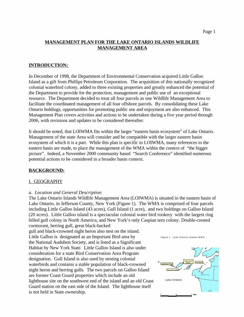
a. Location and General DescriptionThe Lake Ontario Islands Wildlife Management Area (LOIWMA) is situated in the eastern basin ofLake Ontario, in Jefferson County, New York (Figure 1). The WMA is comprised of four parcelsincluding Little Galloo Island (43 acres), Gull Island (1 acre), and two holdings on Galloo Island(20 acres). Little Galloo island is a spectacular colonial water bird rookery with the largest ringbilled gull colony in North America, and New York’s only Caspian tern colony. Double-crestedcormorant, herring gull, great black-backed gull and black-crowned night heron also nest on the island. Little Galloo is designated as an Important Bird area bythe National Audubon Society, and is listed as a SignificantHabitat by New York State. Little Galloo Island is also underconsideration for a state Bird Conservation Area Programdesignation. Gull Island is also used by nesting colonialwaterbirds and contains a stable population of black-crownednight heron and herring gulls. The two parcels on Galloo Islandare former Coast Guard properties which include an oldlighthouse site on the southwest end of the island and an old CoastGuard station on the east side of the Island. The lighthouse itselfis not held in State ownership.

Page 2
b. History While mainland Jefferson County is relatively rich in history, there is little historical informationwritten about the islands in eastern Lake Ontario. Hough (1854) provides some information onMacomb’s original purchase and subsequent ownership of the islands, but little else. According toHough’s account, all of the islands in the St. Lawrence River and eastern Lake Ontario wereincluded in Macomb’s purchase, but patents for these lands were not issued for many years. In1823 Elisha Camp was issued patents for most of Galloo, Little Galloo and Calf Islands alongwith several other islands. The lighthouse parcel on Little Galloo Island, now in New Yorkownership, had previously been patented to the United States of America in 1819 for constructionof a lighthouse. The eastern basin islands are specifically referenced as having “little importance”in the history of the town of Hounsfield, having been used “almost exclusively for agriculture”, inEmerson’s (1898) Our County and its People, A Descriptive Work on Jefferson County, NewYork. A review of of Robinson’s Atlas of Jefferson County, New York, published in 1888indicates that structures were present on both Little Galloo and Galloo Islands. The Coast Guardstation site, was acquired by the United States of America in 1934 for its use as a boat station.
c. Recreational and Cultural BaseThe waters of the eastern basin support significant recreational fishing, sailing and general boatingactivity. Marinas are established at many locations particularly at Henderson Harbor, SacketsHarbor, Chaumont Bay and Mud Bay. Bait and tackle shops are present in the Henderson Harbor,Dexter, Chaumont and Cape Vincent areas. There are many charter fishing services operating inthe eastern basin and in nearby central basin and St Lawrence River waters.
Little Galloo Island has been off-limits to the general public in recent years while in privateownership. Phillips Petroleum Corporation has used the island for fall waterfowl hunting andcontinues to retain the rights to this activity through 2018. As part of the new Lake Ontario IslandsWildlife Management Area access will continue to be restricted to protect the islands value as oneof the premier colonial waterbird nesting areas in North America. Limited, unintrusive public useopportunities will be developed, however to accommodate public interest in visiting the island asa “Watchable Wildlife” site. Substantial information and educational outreach opportunitiesrelated to this significant waterbird resource are also recognized.
Gull Island has been posted as a Wildlife Management Area for a number of years. Because of itssmall size, dense vegetation, and colonial waterbird use, summer use of the island by people hasbeen inconsequential. Some birders undoubtedly approach the island to view nesting birds, andanglers frequently fish from boats nearby. Primary public use of Gull Island is by a small numberof waterfowl hunters during the fall.
The two parcels on Galloo Island are not currently suitable for public use. The lighthouse parcelis inaccessible by boat due to shoals, and the abandoned Coast Guard station no longer hassuitable dockage for access. Additionally, the remaining Coast Guard station structures are in poor repair and the former residence building is known to contain asbestos.
Page 3
II. NATURAL ENVIRONMENT
a. Geology, Soils and Vegetative Cover Geologically, the eastern basin islands are part of a larger area formed from what is referred to asGalloo Rock outcrop (Soil Survey of Jefferson County 1989). Shorelines on the State ownedparcels are typically rock or cobble shore and the thin overlying inland soils tend to be comprisedloam or clay. On Little Galloo Island, substantial organic material is also present from years ofguano deposition by nesting birds.
The vegetation found on Gull Island includes woody species such as black willow, cottonwood, ash, staghorn sumac and silky dogwood. Herbaceous plants include jewelweed, cow parsnip,stinging nettle, nightshade, wild mustard and Virginia creeper (NYSDEC 1994). Detailedvegetative surveys have not been conducted on the Galloo Island or Little Galloo sites.No rare threatened or endangered plant species are known to occur on the WMA. A completeinventory of the vegetative resources of the four parcels is planned for the summers of 2001 and2002. b. Water Resources and Environmental SettingLake Ontario is the lowermost of Great Lakes, with a surface area of over 7,500 square miles anda maximum depth of over 800 feet. The eastern basin, often called the Kingston Basin in Canada,is a relatively small (800 square miles), shallow (maximum depth less than 200 feet) area northand east of the Main Duck Sill which runs from Stony Point, New York to Prince Edward Point,Ontario (44E 54' N). The Basin extends to the Lake Ontario outlet to the St Lawrence River atTibbets Point, New York - Wolfe Island, Ontario (44E 06' N). Roughly half of the area is underU.S. jurisdiction. The area contains a series of rocky points, islands and shoals. There areseveral bays, the largest of which are Henderson Bay, Black River Bay , Chaumont and GuffinBays. Wetlands occupy the more protected areas of the bays. The bays are consideredmesotrophic, open lake areas are oligotrophic. The open lake area is thermally stratified insummer, although thermocline depth is highly variable due to internal seiche action.
Eastern Lake Ontario islands and their adjacent shoals are considered to be significant coastal fishand wildlife habitat by the New York Department of State. These islands and shoals areconsidered to comprise a rare ecosystem in New York State and serve as important habitat forcolonial waterbirds, waterfowl, shorebirds and warmwater fishes. In addition to Little GallooIsland; Calf Island, Fox - Grenadier Islands/Shoal and Stony Point-Limebarrel Shoal are rated“Irreplaceable”, in terms of fish and wildlife value. Under the 1998 New York Department ofEnvironmental Conservation and Office of Parks Recreation and Historic Preservation plan forConserving Open Space in New York State, Eastern Lake Ontario Islands are considered unique,and are listed as a priority project
c. Wildlife ResourcesAs noted above, the eastern basin islands and adjacent waters are considered a significant habitatfor colonial waterbirds, waterfowl, and shorebirds. On LOIWMA itself, the most significantwildlife use is by colonial waterbirds. Both Little Galloo and Gull Islands support breedingcolonies of several colonial nesting species. The most recent population estimates for eachcolonial species are contained in Table I:

Page 4
Table I: Number of Pairs of Breeding Birds on Little Galloo and Gull Islands in 2000
Species Little Galloo Island Gull Island
Ring-billed Gull 53,000 0
Herring Gull 275 45
Gr. Black-backed Gull 12 0
Double-crested Cormorant 5,119 0*
Caspian Tern 1,350 0
Black-crowned Night Heron 1 20
* 478 cormorant nests were removed from Gull Island in 1999 under a USFWS depredation permitissued for maintenance of habitat for Black-crowned night heron.
Use of the State owned LOIWMA parcels by shorebirds and waterfowl is primarily limited tomigration with significant use of adjacent shallow water habitat by waterfowl, and someresting/feeding activity by shorebirds. No mammalian species have been observed on either LittleGalloo or Gull Islands, but several mainland mammal species are known to exist on Galloo Island.
d. Aquatic ResourcesSmallmouth bass are the most abundant and widespread Eastern Basin sport fish despitesignificant declines in recent years (Chrisman and Eckert 1999). It is still the most sought-aftersport fish, attracting over 35,000 directed angler trips in 1998 (McCullough and Einhouse 1999).Walleye have increased in abundance and become a significant part of the fish community andfishery in the last decade. They are now the second most commonly sought and harvested sport fishin Lake Ontario’s eastern basin (McCullough and Einhouse 1999). Northern pike and largemouthbass are locally abundant in protected bays and provide a small directed fishery. Chinook salmonand lake trout are seasonally abundant and provide a high profile fishery. Steelhead (rainbowtrout) provide a noteworthy tributary fishery from fall through early spring. The trout and salmonfishery is less numerically significant in the Eastern Basin than in the adjacent Central Basin andis a relatively small fraction of Eastern Basin fishing effort.
Yellow perch are the most commonly harvested pan fish, although harvests are currently wellbelow historical levels. Brown bullhead also provide substantial harvest opportunity (McCulloughand Einhouse 1999).
Alewife abundance has declined dramatically in recent years (Lantry and Shaver 1998).Nonetheless alewife are present in the basin from late spring through fall and remain an importantfood source for most piscivores. Minnows such as spottail shiners and bluntnose minnows arealso significant prey items. Crayfish are the major prey of smallmouth bass.

Page 5
GOALS AND OBJECTIVES:
The Department has adopted the following Goal for the management of the eastern basin of LakeOntario:
Improve the benefits people derive from Lake Ontario’s eastern basin ecosystem by: 1)restoring the structure and function of the warmwater fish community, 2) reducing the negativeimpacts of double-crested cormorants on nesting habitats and other colonial waterbird species,3) improve the quality of smallmouth bass and other fisheries, and 4) foster a greaterappreciation for Great Lakes colonial waterbird resources.
The following complimentary Goals and Objectives have been established for managing the LakeOntario Islands Wildlife Management Area.
Goals:
I Protect, maintain and manage the diversity of colonial waterbirds nesting on Little Gallooand Gull Islands to, 1) enhance their suitability for the full range of colonial waterbirdspecies found within the Lake Ontario eastern basin, and 2) in support of the goal establishedfor the eastern basin fisheries and colonial waterbird resources.
II) Improve public appreciation, use, and enjoyment of the LOIWMA colonial waterbirdresource through development of appropriate use facilities and opportunities to accomplishunintrusive use.
III) Foster and promote greater appreciation for the unique resources of the LOIWMA and theeastern basin to allow for improved social and economic benefit to local communities andNew York State residents.
Objectives:
Ia) Limit disturbance to colonial waterbirds on Little Galloo and Gull Islands through posting,consolidation of research and management activities and other protective measures.
Ib) Annually monitor the status of colonial waterbird species using the LOIWMA to detect longterm trends in abundance.
Ic) Conduct research and management activities as necessary to ensure suitable balance existsto support a diverse compliment of colonial nesting species and a healthy recreationalfishery.
IIa) By March, 2002, assess the potential for desirable, unintrusive public use facilities thatallow for access to the LOIWMA resource.
IIb) By June, 2004, construct appropriate use facilities to meet identified demands for access toLOIWMA resources.

Page 6
IIIa) With public input, finalize the Draft LOIWMA Management Plan by June, 2001.
IIIb) Develop and distribute periodic informational material about LOIWMA, its uniqueresources, and opportunities for enjoyment, (eg kiosks at shoreline access points,interpretive brochure), by May, 2004.
IIIc) Promote colonial waterbird related research activities by universities and other qualifiedinterests to further our understanding of the ecology of the eastern basin.
IMPLEMENTATION: (THE PLAN)
I SECURITY AND ACCESS
a. Posting and PatrollingThe unique colonial waterbird resources found on Little Galloo and Gull Islands merit
protection from unregulated disturbance. Colonial nesting species are prone to colonyabandonment from both repetitive and inappropriate levels of disturbance. Both islands willinitially be designated and posted as “restricted access” sites to limit disruptions which mightjeopardize use of the islands by colonial nesting species. Public use of the two islands at timesother than the bird nesting season will be considered if compatible with the goals of this plan. The lighthouse site on Galloo Island will be posted similarly to the two smaller islands, althoughaccess to this location is very limited due to surrounding shoals. The Department is currentlystudying deed restrictions and public use potential of the old Coast Guard station to determine itsbest use designation. Posting of the parcels will be done annually as necessary, and patrollingwill occur as part of the local Environmental Conservation Officers routine boat patrol.
b. AccessAccess to the LOIWMA is understandably, limited to boaters. Use facilities on the Area
itself, will be provided within the capacity of the Area to support use while maintaining the qualityof the resource. Department sponsored research and management activities will continue and willaccommodate interested individuals and media within available logistical constraints. Access tolegitimate university and private researchers will also be granted for approved projects. Publicaccess, though limited will include designated colonial waterbird viewing moorings andpotentially, viewing blinds on Little Galloo Island, and safe harbor/dockage at the old Coast guardsite. Additionally, day use facilities may be developed, if allowed by deed, at the Coast Guardsite. Preliminary results of a Cornell “situation analysis” study on potential desirable public useof the WMA suggest that local communities do not consider the State WMA to have a high publicuse potential (Schusler and Decker 2000), but the more recent community based “SearchConference has confirmed public desire for viewing and safe harbor facilities(Schusler andDecker 2001). Final decisions on the development of additional public access facilities will bemade based on Search Conference recommendations and public input on the Draft plan.

Page 7
II WILDLIFE MANAGEMENT
a. Monitoring Colonial Waterbirds The most outstanding feature of LOIWMA is the colonial waterbird colony on Little Galloo
Island. Although the diversity of nesting species is relatively small at six, the sheer number ofbirds using the island, some 60,000 pairs, is unique in the Great Lakes system. Maintaining thiscolony of nesting birds and its diversity is a focus of this plan. Annual counts and estimates foreach species (with the exception of ring-billed gulls, which due to numbers, will be censussedevery five years) will be conducted to understand long term population trends. Productivityestimates as commenced in 1999 will continue annually for all species nesting on the island.
Gull Island, although a much smaller waterbird nesting site, will be monitored similar toLittle Galloo Island. Annual counts of nesting species and productivity estimates will becompleted.
The two parcels contained on Galloo Island have little potential for nesting colonialwaterbirds. Each will annually be inspected for potential use by colonial species. b. Research
LOIWMA is well suited to host a variety of research activities in addition to those currentlyongoing. From a biological perspective, questions about individual species, interactions betweenwaterbird species, and developing a better understanding of the overall colony and its role in theecosystem, are all topics worthy of further pursuit. Additionally, dense concentrations of nestingwaterbirds can be a good barometer of ecosystem conditions. The recent Type E botulismoutbreak on Lake Erie could spread to Lake Ontario for example. The development of amonitoring plan to watch for this and other diseases potentially occurring on Lake Ontario, isadvisable. Qualified researchers wishing to study these various aspects of the colony will beencouraged to do so.
Ongoing research is currently directed at the impacts of double-crested cormorants on warmwater fish stocks, and the impacts of cormorant management strategies on the overall colony. These studies will continue through at least 2,004. Research initiated in 2000 includes a threeyear cormorant satellite telemetry study to gain information about natural movements and colonyabandonment due to management activities. c. Double-crested Cormorant Management
Double-crested cormorant management within the eastern basin has become a significantpolitical, social and biological issue over the past several years. Growing cormorant populationshave displaced black-crowned night heron from Little Galloo Island and could threaten theircontinued existence on Gull Island. Continued expansion of the cormorant population also hasincreased the potential for colonization of new sites, raising concerns about private property andpotential impacts to other colonial waterbird colonies. Following the results of studies conductedin 1998 which established a link between reduced smallmouth bass numbers and cormorantpredation, the Department, in 1999, initiated a management program to reduce cormorant numbers. The current management program has a goal of restricting cormorant nesting to only Little GallooIsland within U.S. waters of the eastern basin, and reducing the nesting population on Little Gallooto 1,500 pairs by 2004. The techniques used in 1999 included removal of cormorant nests fromGull and privately owned Bass Island, and the oiling of all accessible cormorant nests on Little

Page 8
Galloo Island to reduce hatching success. The management program continued in 2000. Becausecormorants are a federally protected species, USFWS depredation permits are required andobtained annually. The Department intends to continue to manage cormorants in the eastern basintoward the goal of 1,500 nesting pairs. The Department may also seek additional authority toremove adult cormorants from the Little Galloo colony if necessary to reach the population goalwithin five years.
d. Habitat ManipulationHabitat management activities on LOIWMA will be limited, particularly on the parcels
supporting waterbird colonies. Habitat alterations designed to favor less abundant species will beconsidered as necessary to meet the waterbird objectives of the plan. Such actions might include,maintenance of shrub cover on Gull Island for BCNH nesting, experimental re-establishment ofwoody species on Little Galloo, and erection of various exclusion devices to maintain nest sitesfor species being “out-competed” by other, more numerous nesters.
Limited habitat management actions are being considered for the lighthouse and Coast Guardsites on Galloo Island. On these sites, establishment of perennial wildlife food and cover will beconsidered along with minor clearing and dressing to accommodate wildlife related use.
III PUBLIC USE
a. Information and EducationThe importance of LOIWMAs colonial waterbird resources is apparently not well known or
understood by the general public. Results of a “Situation Analysis” study conducted by Schuslerand Decker (2000) suggested that many local residents do not view the LOIWMA resourcepositively from an economic or social perspective. Some who were interviewed, however, didsee potential for improved social and economic benefit from this resource. When queried about thebiological significance of the eastern basin’s waterbird resource, many who were interviewed,similarly did not express a positive perception. Part of the reason for this negative perceptionrelates to the controversy over cormorants and their real and perceived impacts to the recreationalfishery. Continued steps towards resolving the cormorant issue will be necessary to effectivelyassess the informational and educational potential of LOIWMA. In addition, little direct attentionhas been focussed on providing the public with positive, accurate information about the waterbirdresource, and even less toward promoting it.
The results of the Search Conference which followed the “Situation Analysis”, did yield astrong recognition of the value of waterbird resources within the basin. More information aboutand promotion of these resources will be initiated as a result.
Communications efforts under this plan are being developed within the following time line.
1. February 2000; review preliminary results of qualitative interviews conducted by Cornell’s Human Dimensions Research Unit to identify key communications and education issues.[COMPLETED]

Page 9
2. February 2000; provide input to Cornell researchers to continue quantitative inquiry on the potential for an improved community view of the LOIWMA resource.[COMPLETED]
3. November 2000; initiate public dialogue on the draft LOIWMA plan, and invite input to the planning process.[SEARCH CONFERENCE- COMPLETED]
4. June 2001; finalize the LOIWMA plan with included public input.
5. June 2000-2005; produce and distribute periodic LOIWMA information, in a variety of media formats, (brochures, kiosks, slide programs, popular articles, etc.) based on needs identified in 1&2 above.
6. May 2001-2005; continue to maintain open dialogue with local publics on LOIWMA management and foster partnerships aimed at appreciation of LOIWMA resources. In addition to the communications actions highlighted above, the eastern basin Search
Conference yielded eight “action planning templates” related to a broader recognition of theeastern basin resource (Appendix I) . These actions include efforts relative to communityplanning, ecosystem management, education, resource use and tourism. Each extends beyond thephysical boundaries of the State WMA, and would include development by outside parties, withDEC serving as a partner rather than as the lead. The Department remains a willing partner in thedevelopment and implementation of these actions. b. Development of Use Facilities
A number of opportunities exist to enhance or maintain public use of the Lake Ontario Islandsparcels and/or waters of the basin. Several of the “action plans” identified in the SearchConference confirm a need and desire for beneficial use facilities or activities which mightimprove the overall quality of the eastern basin experience. Specific to the category of “use”, thefollowing actions and time-lines have been incorporated into the plan.
1. June 2002, Install two mooring buoys in proximity to Little Galloo Island for use by boaterswishing to view colonial waterbirds on the island.
2. June 2002, In cooperation with NY Parks and Recreation, establish channel markers into GillHarbor (old Coast Guard Station) on Galloo Island to provide safe harbor to boaters on thelake’s open waters.
3. March-June 2002, Assess the feasibility, costs and compatibility of constructing a publicwaterbird viewing structure on Little Galloo Island. If feasible, seek funding resources forconstruction in 2003.
4. May-July 2002, Explore the possibility of establishing perennial wildlife food/coverdemonstration plantings on the Galloo Island Parcels.
5. May-September 2003, Develop if permitted by deed, a use facility on the Galloo Island sitesto include limited dockage (old Coast Guard station), wildlife viewing signage and primitiveovernight accommodations (by permit).

Page 10
IV PUBLIC INPUT- SEARCH CONFERENCE
As noted throughout this Management Plan, the Lake Ontario Islands Search Conference wasdesigned to provide public guidance to the development of this Management Plan by creating acommunity view of desirable outcomes within the basin. In total eighteen “action templates” wereproduced, with eight (noted in III, Public Use) to be pursued by a lead entity other than NYDEC. The remaining ten, while not articulated verbatim in this plan, have been incorporated into the text,planned actions or are a part of other Regional program work planning. For reference, they arelisted below with NYDEC comment.
Action Statement Commit DEC to an ecosytem wide approach to the management of all species in ecologicalbalance to ensure management accommodates public interests.
CommentThe goals and objectives adopted for LOIWMA attempt to reflect an ecosystem approach to themanagement of the WMA and surrounding waters of the basin. Admittedly, they do not includemany of the resource issues found along the shoreline (Eg. Shorebird use, dune erosion, nonpointpollution, etc.), but do nest within broader NYDEC management objectives.
Action Statement Maintain a diversity of fish species through the use of existing fish stocking programs to provide aquality fishery.
CommentExisting fish stocking and management programs are scheduled to continue into the future.
Action StatementReview and react to F&WS report (Cormorant Management DEIS) due in 2001.
CommentNYDEC has been involved in providing comments to the Fish and Wildlife Service throughout theDEIS process and will review and comment on the document when available.
Action StatementConduct an inventory of ecological resources of the State owned islands in the eastern basin ofLake Ontario.
CommentThe fish and wildlife resources of the LOIWMA are well documented currently. Improvedbaseline inventory of the flora are scheduled for 2001 and 2002.
Action StatementReduce balance and control the number of double-crested cormorants for the benefit of the floraand fauna of the eastern basin.
Page 11
CommentNYDEC intends to continue with the long term management program identified in its 2000 EIS. We will continue to work cooperatively with the Fish and Wildlife Service and officials from theCanadian government to ensure the most productive results over time.
Action StatementEnsure appropriate use and access facilities and opportunities are include in the NYSDECLOIWMA plan regarding the eastern basin islands.
CommentEach of the use and access proposals made by Search Conference participants are incorporatedwithin the Management plan.
Action StatementEstablish a marked and usable safe harbor at Galloo Island (Gill Harbor) in spring 2001.
Comment Referenced within the plan, channel markers will be installed by New York State OPRHP bysummer boating season 2002.
Action Statement Gill Harbor (Coast Guard site) use facilities
CommentDevelopment of use facilities is retained within the management plan contingent on legaldetermination of deed restrictions.
Action Statement Establish anchor buoys (with signage) to provide view of bird populations of Little Galloo andGull Islands.
Comment Anchor buoys (2) are scheduled for placement at Little Galloo Island by mid June 2002. NYDECwill publicize availability for use, signage will follow at a later date. No buoys are planned forGull Island due to lesser viewing opportunity. Gull Island resources will also be betterpublicized, however for near shore boater awareness.
Action Statement Long range Little Galloo Island waterbird viewing opportunities (dock and platform).
CommentA feasibility study on the potential for a dock and waterbird viewing platform on Little GallooIsland has been incorporated into the management plan.

Page 12
REFERENCES CITED
Chrisman, J.R. and Eckert, T.H. 1999. Population Trends Among Smallmouth Bass in the EasternBasin. In Final Report: To Assess the Impact of Double-crested Cormorant Predation on theSmallmouth Bass and Other Fishes of the Eastern Basin of Lake Ontario. NYSDEC Special Report.
Emerson, E.C. 1898. Our County and Its People- A descriptive Work on Jefferson County, NewYork. The Boston History Company.
Hough, F.B. 1854. History of Jefferson County, New York. Sterling and Riddell, Watertown, NY. Lantry, B.F. and Shaver, T. 1998. The Status of the Pelagic Prey Fish in Lake Ontario 1997. NYSDEC Annual Report to the Great Lakes Fishery Commission, Lake Ontario Committee.
McCullough, R.D. and Einhouse, D.W. 1999. Lake Ontario-Eastern Basin Creel Survey. In Final Report: To Assess to the Impact of Double-crested Cormorant Predation on to the Smallmouth Bass and Other Fishes of to the Eastern Basin of Lake Ontario. NYSDEC Special Report.
NYSDEC. 1994. Gull Island Wildlife Management Area Biodiversity Inventory Final Report.New York Natural Heritage Program, Latham, NY.
Robinson’s Atlas of Jefferson County, New York. 1888. E. Robinson, Publisher. 82 & 84 NassauSt., New York, NY.
Schusler, T.M. and D.J. Decker. 2000. Lake Ontario Islands Wildlife Management Area SituationAnalysis; Interim Report from Phase I of Inquiry. Department of Natural Resources, CornellUniversity, Ithaca, NY.
Schusler, T.M. and D.J. Decker. 2001. Lake Ontario Islands Search Conference Summary Report.Department of Natural Resources, Cornell University, Ithaca, NY.
USDA-SCS. 1989. Soil Survey of Jefferson County, New York.

Eastern Lake Ontario Basin Search Conference
Action Planning Template - COMMUNITY PLANNING
Action Statement To protect, enhance, and/or prevent deterioration of resources alongthe shore of Eastern Basin communities.
Action Strategy -- Sequence of ActivitiesCreate a council of governments
{ - Contact each jurisdiction and request a representative.ST { - Convene meeting to discuss concept.
{ - Reach consensus of need and direction.
{ - Pull together information needed.{ - Develop list of resources and players to involve.
LT { - Convene larger meeting to report out recommendations.{ - Create COG.{ - Develop regulations to protect, enhance, and/or prevent deterioration of
resources along shore of Eastern Basin communities.
Others to involveIdentify
Information Needed Resources Needed
EllisburghHendersonHounsfieldBrownvilleLymeCape VincentClaytonAlexandria
EllisburghMannsvilleSacketsDexterBrownvilleGlen ParkChaumontCape VincentClaytonAlex Bay
All involved jurisdictionsS Which have/lack regsS How they are
implementedS Geographic boundaryS Procedural how to
S Staffing and T/AS ResearchS Resources
Jeff Co Planning?
Jefferson County, DEC
Immediate Actions
S Contact JCP Dept for list of jurisdictional contacts and list ofwho has zoning.
S Contact each jurisdiction and request a rep.S Contact Black River St. Lawrence Resource Conservation and
Development office to see what they available to the process.
Person Responsible
Gary
Bill
Date
11/16/00
11/13/00
Meeting Coordinator/Key Contact Person(s)
Next Meeting
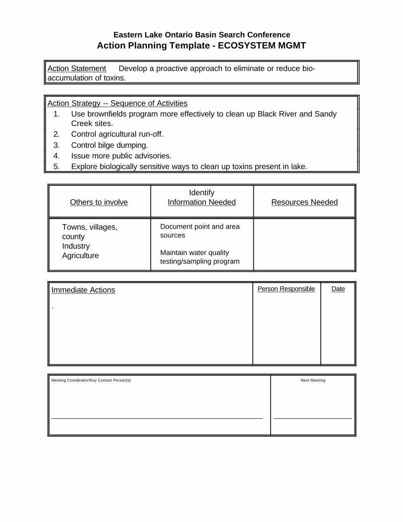
Eastern Lake Ontario Basin Search Conference
Action Planning Template - ECOSYSTEM MGMT
Action Statement Develop a proactive approach to eliminate or reduce bio-accumulation of toxins.
Action Strategy -- Sequence of Activities1. Use brownfields program more effectively to clean up Black River and Sandy
Creek sites.2. Control agricultural run-off.3. Control bilge dumping.4. Issue more public advisories.5. Explore biologically sensitive ways to clean up toxins present in lake.
Others to involveIdentify
Information Needed Resources Needed
Towns, villages, countyIndustryAgriculture
Document point and areasources
Maintain water qualitytesting/sampling program
Immediate Actions
.
Person Responsible Date
Meeting Coordinator/Key Contact Person(s)
Next Meeting

Eastern Lake Ontario Basin Search Conference
Action Planning Template - EDUCATION
Action Statement Long term: Set up and maintain a remote video camera link fromLittle Galloo to create an awareness of the bird populations on the islands.
Action Strategy -- Sequence of Activities1. Research technical specifications -- Solar power? Battery power? Size? *Still
photos*2. Research cost3. Seeking funding -- Grants? Fines?4. Set up web site5. Advertise6. Maintenance7. Develop classroom activity package to coordinate with photos
a) Connections with existing information
Others to involveIdentify
Information Needed Resources Needed
Local internet providerDECCoop ExtCornell Lab of Ornithology ($, “citizen science program”)Sea GrantMontezuma NWF (for technical info)
Camera specsSize -- how intrusive would
camera be
Web serverTechnology info
CameraPower supply
Immediate Actions
Contact Cornell Ornithology
Person Responsible
Molly Thompson
Date
Meeting Coordinator/Key Contact Person(s)
Molly
Next Meeting
In Next Months
Eastern Lake Ontario Basin Search Conference
Action Planning Template - EDUCATION
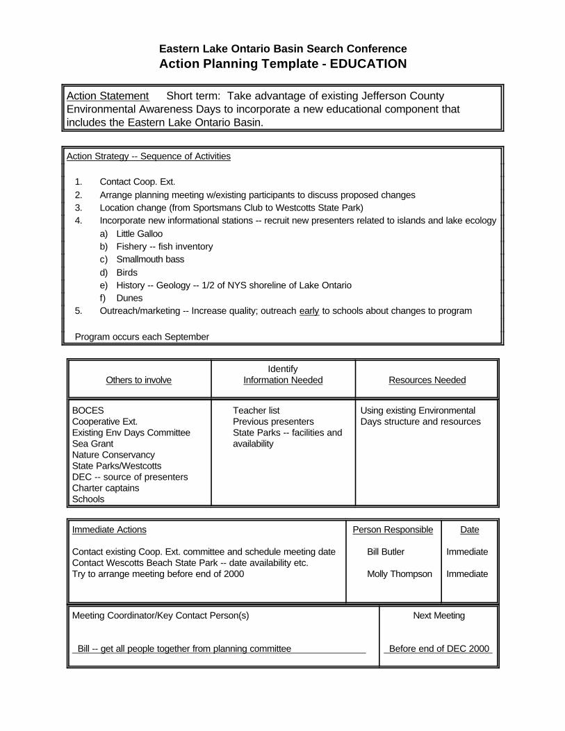
Action Statement Short term: Take advantage of existing Jefferson CountyEnvironmental Awareness Days to incorporate a new educational component thatincludes the Eastern Lake Ontario Basin.
Action Strategy -- Sequence of Activities
1. Contact Coop. Ext.2. Arrange planning meeting w/existing participants to discuss proposed changes3. Location change (from Sportsmans Club to Westcotts State Park)4. Incorporate new informational stations -- recruit new presenters related to islands and lake ecology
a) Little Galloob) Fishery -- fish inventoryc) Smallmouth bassd) Birdse) History -- Geology -- 1/2 of NYS shoreline of Lake Ontariof) Dunes
5. Outreach/marketing -- Increase quality; outreach early to schools about changes to program
Program occurs each September
Others to involveIdentify
Information Needed Resources Needed
BOCESCooperative Ext.Existing Env Days CommitteeSea GrantNature ConservancyState Parks/WestcottsDEC -- source of presentersCharter captainsSchools
Teacher listPrevious presentersState Parks -- facilities andavailability
Using existing EnvironmentalDays structure and resources
Immediate Actions
Contact existing Coop. Ext. committee and schedule meeting dateContact Wescotts Beach State Park -- date availability etc.Try to arrange meeting before end of 2000
Person Responsible
Bill Butler
Molly Thompson
Date
Immediate
Immediate
Meeting Coordinator/Key Contact Person(s)
Bill -- get all people together from planning committee
Next Meeting
Before end of DEC 2000
Eastern Lake Ontario Basin Search Conference
Action Planning Template - EDUCATION
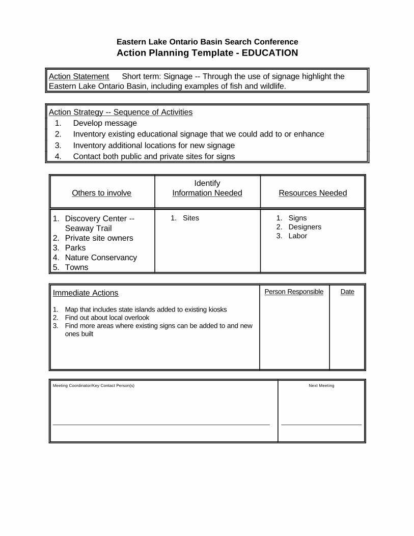
Action Statement Short term: Signage -- Through the use of signage highlight theEastern Lake Ontario Basin, including examples of fish and wildlife.
Action Strategy -- Sequence of Activities1. Develop message2. Inventory existing educational signage that we could add to or enhance3. Inventory additional locations for new signage4. Contact both public and private sites for signs
Others to involveIdentify
Information Needed Resources Needed
1. Discovery Center -- Seaway Trail
2. Private site owners3. Parks4. Nature Conservancy5. Towns
1. Sites 1. Signs2. Designers3. Labor
Immediate Actions
1. Map that includes state islands added to existing kiosks2. Find out about local overlook3. Find more areas where existing signs can be added to and new
ones built
Person Responsible Date
Meeting Coordinator/Key Contact Person(s)
Next Meeting
Eastern Lake Ontario Basin Search Conference
Action Planning Template - RESOURCE USE
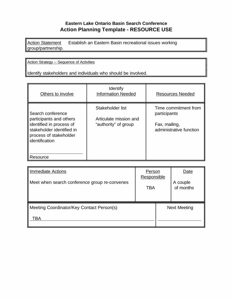
Action Statement Establish an Eastern Basin recreational issues workinggroup/partnership.
Action Strategy -- Sequence of Activities
Identify stakeholders and individuals who should be involved.
Others to involveIdentify
Information Needed Resources Needed
Search conference participants and othersidentified in process ofstakeholder identified inprocess of stakeholderidentification
Resource
Stakeholder list
Articulate mission and“authority” of group
Time commitment fromparticipants
Fax, mailing,administrative function
Immediate Actions
Meet when search conference group re-convenes
PersonResponsible
TBA
Date
A couple of months
Meeting Coordinator/Key Contact Person(s)
TBA
Next Meeting
Eastern Lake Ontario Basin Search Conference
Action Planning Template - TOURISM
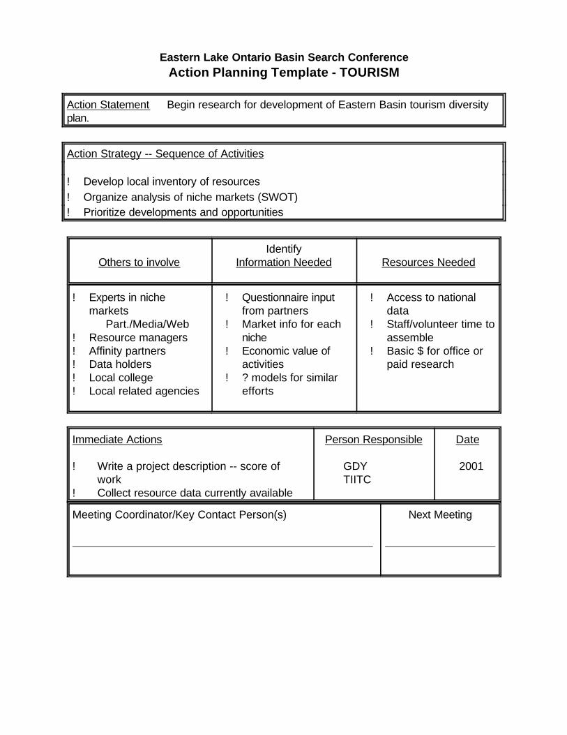
Action Statement Begin research for development of Eastern Basin tourism diversityplan.
Action Strategy -- Sequence of Activities
! Develop local inventory of resources! Organize analysis of niche markets (SWOT)! Prioritize developments and opportunities
Others to involveIdentify
Information Needed Resources Needed
! Experts in nichemarkets
Part./Media/Web! Resource managers! Affinity partners! Data holders! Local college! Local related agencies
! Questionnaire inputfrom partners
! Market info for eachniche
! Economic value ofactivities
! ? models for similarefforts
! Access to nationaldata
! Staff/volunteer time toassemble
! Basic $ for office orpaid research
Immediate Actions
! Write a project description -- score ofwork
! Collect resource data currently available
Person Responsible
GDYTIITC
Date
2001
Meeting Coordinator/Key Contact Person(s)
Next Meeting

Eastern Lake Ontario Basin Search Conference
Action Planning Template - TOURISM
Action Statement Make the Eastern Basin a premier destination for resource-basedtourism, emphasizing a diversity of activities.
Action Strategy -- Sequence of Activities
! Develop Eastern Basin tourism plan focused on prioritizing development of futurediverse tourism options
! Share opportunities/gap with private sector! Develop public and private infrastructure to support tourism activities identified! Implement marketing programs targeting tourism activities identified! Educate tourism industry in new skills needed and public sector providers! Focus existing public resources on accomplishing plan
Others to involveIdentify
Information Needed Resources Needed
! DEC! Private tourism
operators! Resource managers ! Government and
agencies! Affinity partners! Investors $! Non-profits! Colleges/schools! Coop Extension
(See research objective) ! $! Access to
recreational areas! Infrastructure (rooms,
roads, F&B, etc.,etc.)
S Private investmentS State/Fed assistance
programs andincentives
Immediate Actions
Begin research -- See page #2
Utilize existing forums to convey information anddevelop interest
Facilitate process to bring public/private funderstogether to create tourism development fund
Person Responsible
JCJDCTIITCC of C’s
Coop Extension
Date
Begun &ongoing
Meeting Coordinator/Key Contact Person(s)
Next Meeting