land acquisition for urban expansion - slu.sepub.epsilon.slu.se/8537/1/msangi_d_120126.pdf ·...
TRANSCRIPT

Land Acquisition for Urban Expansion: Process and Impacts on Livelihoods of Peri Urban
Households, Dar es Salaam, Tanzania
Daniel Eliwaha Msangi
Faculty of Natural Sciences and Agricultural Sciences Department of Urban and Rural Development,
Uppsala
Licentiate Thesis
Swedish University of Agricultural Sciences
Uppsala, 2011

Reports Department of Urban and Rural Development
2011:2 Cover: Map showing Administrative Boundaries of Wazo Ward and the
Project Area for the 20,000 Plots Project referred to in this report as Wazo-Mivumoni.
ISSN: 1654-0565 ISBN 978-91-85735-22-8 ©Msangi Daniel Eliwaha, Uppsala Print: SLU Service/Repro, Uppsala 2011
i
ABSTRACT Cities are growing in terms of economic activities, space and population thus over spilling in peri urban areas. Low population densities and land values have made the peri urban areas the target for land acquisition to accommodate planned expansion processes. In Tanzania, the Government initiated the 20,000 Plots Project in 2002 to among others, address critical shortage of planned and surveyed plots in the city and check proliferation of informal settlements. The Project was implemented in 12 areas in the City of Dar es Salaam, one of them being Wazo-Mivumoni. This study explored the processes and impacts of land acquisition on the livelihoods of peri urban households. It also built an understanding of peri urban areas in the Tanzanian context and further contextualized peri urban livelihoods in Wazo-Mivumoni. Data was collected through official, households and key informants interviews, likewise documentary review. An overarching understanding was drawn from the National Constitution (1977) that provides for the right of residents to own properties, the right to protection of their properties and payment of fair and adequate compensation subject to lawfully acquisition. Although the principal legislations for land acquisition recognize market values, government-regulated rates were instead used in Wazo-Mivumoni. The implementation process was characterized by lack of appreciation of the drivers of peri urban livelihoods, non-adherence to legal provisions and non-observarance of professional ethics. Further, the laws were found to be insufficient to adequately respond to present social and economic conditions. The implementation of the project amidst these conditions resulted to loss of assets, disruption of social networks and family ties. All these undermined household’s capacity to sustain livelihoods after project implementation. Among the strategies adopted to overcome these impacts include intensification and increased innovation on farming and animal keeping; reliance on family support as well as reduction of family sizes. Despite the shortcomings, some positive gains including establishment of new economic activities (private schools, retail business and access to planned and surveyed plots) were realized.
ii
Residents participation and awareness creation during and after implementation is seen as paramount considerations for successful interventions. Others include establishment of a land cadastre to realise effective and efficient land administration system, establishment of a neutral body to verify valuation reports as well as provision of alternative plots as a measure to restore affected households to same condition as prior to acquisition. Key words: peri urban area, livelihoods, land acquisition, market value, Dares Salaam, Tanzania Authors Address: Daniel E. Msangi, SLU, Department of Urban and Rural Development, Box 7012, 750 07 Uppsala, Sweden. Email: [email protected]; and [email protected]

iii
ACKNOWLEDGEMENT First and foremost I am extending my sincere thanks to Sida for the financial support that enabled me to successfully undertake this study. Accomplishment of this study entailed among others, attending courses, participating in conferences as well as field studies for data collection. All these would not have been possible without the financials assistance from Sida and the Swedish Government at large. I also thank the Swedish Embassy in Dar es Salaam for all the assistance whenever I sought permit to enter Sweden. My supervisors, Prof. Rolf Johansson, Dr. Madeleine Granvik and Prof. Wilbard, J. Kombe; I thank you a lot for all the intellectual guidance that enabled me to produce this report. Your professional advice and critique were vital to shape my ideas to this level of a professional output. I am also extending my sincere appreciation to the Swedish and Tanzania Coordinators of Sida-ARU Cooperation Programme for all administrative, technical and logistical support that enabled me to keep track of time. Special thanks are due to Dr. Hidaya Kayuza who heartedly fought through official bureaucracies both within and outside Ardhi University whenever possible. The management of Ardhi University also deserve a special mention for not only granted me permission to undertake this course, but also the financial assistance for some of the activities that were not covered by the Sida budget. I also thank the management of the Institute of Human Settlements Studies (IHSS), where I work, for allowing me more time to concentrate on my studies. I am also extending the same to the management of the Department of Urban and Rural Development at the Swedish University of Agricultural Sciences (SLU) for all the administrative assistance throughout my stay in Sweden. I am also extending my sincere thanks to the family of Mrs. Eva-Lena Heywood, whom I stayed with at Svankarrsvagen from September to December, 2011. This report also benefitted from technical input of many people through advice and critiques. Dr. Shaaban Sheuya and Dr. Komu Felician deserve a special mention here. I am thankful for their critique which helped to sharpen the analysis of some of the issues covered in this

iv
study. Many thanks are also due to Prof. Thomas Hakansson (from SLU) and Prof. Dirk Urban Vestbro (from KTH) who read my draft report and gave comments and criticism during my final seminar at SLU in October 2011. The comments were very crucial to identify loopholes that needed to be sealed off prior to producing the final report. My colleagues at IHSS also deserve my appreciation. I benefitted a lot through organised formal presentations as well as informal discussions. All these were important to give different perspectives with which I was able to approach my study. My office mate, Dr. Riziki Shemdoe, you always encouraged me to go for PhD studies. This was real a challenge that I lived with and finally it is now coming true. I thank him for the inspiration. Equally appreciated is Mama Mary Mwangomango, the OMS at IHSS who typed the draft manuscript for the empirical chapters of this work. Access to data and information (reports and interviews) was quite vital to facilitate production of this work. In recognition of this, I like to extend my heartfelt gratitude to all those who assisted me directly or indirectly. From the Ministry of Lands, Housing and Human Settlements Development; my appreciation goes to Mr. Lameck Mtui, Mr. Kamara Arnold and Mr. Tesha Samia. I also extend my sincere thanks to the Official of the 20,000 Plots Project who granted me several rounds of interviews as well as sharing of the research results which helped to triangulate the information from household interviews thereby reducing biases. My thanks are also due to the staff of the three Municipalities of Dar es Salaam who helped me to access data and information in their respective Municipalities. These include Mr. Mbembela Paul (Ilala Municipality); Mr. Fortidas Kagimbo and Mr. Mndewa Lucian (Temeke Municipality); Ms. Veronika Igoko, Mr. Reuben Emmanuel, Mr. Edward Mlando and Ms. Lucy Denis (Kinondoni Municipality). I also like to thank all the Ward leaders whom I interviewed during the pilot survey. These include Ms. Eliza Mbalale (WEO) and Ms. Suzgo Alexander (Community Development Officer), Bunju Ward; Mr. Sylivester (WEO) and Ms. Silfrose Godian (Community Development Officer and Assistant WEO), Mbweni Ward; Mr. Douglas Macha (MEO for Kichangani), Kibada Ward; Mr. Hassan Pongwa (WEO), Mrs. Catherine Sencudo (Ward Education Coordinator and Assistant

v
WEO) and Mr. Hussein Mhoma (Ward Livestock Officer), Mjimwema Ward; Ms. Fatuma Nassir (Secretary to the WEO), Kunduchi Ward; Mrs. Rehema Mlongakweli (WEO), Kibamba Ward; Mr. Jonathan Kaihura (WEO), Mr. Mpore (Member of the Mtaa Government for Bonyokwa), Mr. Gafunya Abdalla (Chairman, Kinyerezi Mtaa area), Ms. Lucresia Shayo (MEO for Kifuru Mtaa area), Kinyerezi Ward; Mr. Abdallah Omari Kunja (Ward Chairman), Mabwepande Ward; Mr. Ally Kambi (Assistant to the WEO), Ms. Diana Stephen Mbena (MEO for Kigezi Mtaa area), Chanika Ward; Mr. Ligile Hassan (Chairman of the Ward Development Committee), Toangoma Ward; Ms. Neema Karumba and Mr. Shaban Kambi (WEOs), Mr. Kimolo Kimolo (MEO for Kisanga); Wazo Ward, and Mr. Mzaganya (WEO), Kwembe Ward. I am also extending many thanks to the people I interviewed in Wazo-Mivumoni which constituted case study for in-depth interviews. These include Mr. Kimolo Kimolo, Enock Manyovu, Kapanya, Deo Kamugisha and Ngawanje, to mention just a few. In a special way, I am extending my sincere thanks to all the households in Wazo-Mivumoni who responded to my questionnaire. I am also very thankful to the field assistants, Ms. Kavishe Angela and Mr. Yamuno Augustine who diligently assisted with data collection, recording, coding as well as partial analysis of the collected data during analysis meeting. I was impressed by their enthusiasm and great interest they developed into my work. More so, I thank Yamuno for processing the maps appearing in this report. In the same vein, I also like to extend my gratitude to Mr. Kamaze of the Survey and Mapping Division of the Ministry of Lands in Dar es Salaam who assisted me to access basic GIS data which was instrumental for preparation of GIS maps appearing in this report. I am also thankful to Ms. Dawah Mushi, Mr. Mkumbo Stanley, Mr. Msami Joel, Mr. Mbisso Daniel and Ms. Sarah Phoya - fellow PhD students under Phase IV of Sida support to Ardhi University. The sharing, encouragement and collective pushing was quite instrumental to survive through the hard times encountered both in Tanzania and Sweden. I am also extending my heartfelt gratitude to my family - Janeth; Godlove-Michael and Judith-Haika for not only enduring during my absence, but also for the moral support they always accorded me. Their

vi
tears whenever I travelled away gave me another reason to successfully accomplish this work. I am also thankful to my mother Christmary Lyimo for all the prayers. I am grateful that finally, I have made it. It is not easy to mention the names of each and every one who assisted me in the production of this report. I therefore request them to accept my sincere thanks even if their names are not appearing above. Although many people were contacted and helped me in various ways, any shortcoming that may be associated with this report remains solely mine.

vii
TABLE OF CONTENTS �ABSTRACT ______________________________________________ i ACKNOWLEDGEMENT __________________________________ iii TABLE OF CONTENTS ___________________________________ vii LIST OF TABLES ________________________________________ xi LIST OF FIGURES _______________________________________ xii LIST OF MAPS __________________________________________ xii LIST OF PLATES ________________________________________ xii ANNEXES ______________________________________________ xii ACRONYMS ___________________________________________ xiii 1. INTRODUCTION _____________________________________ 1
1.1 Background to the study ____________________________ 1 1.2 Understanding Peri Urban Area (PUA) _________________ 1 1.3 Social capital and support to livelihoods in peri urban context
________________________________________________ 8 1.4 Urban expansion processes and the peri urban areas _______ 8 1.5 The research problem _____________________________ 10 1.6 Research questions________________________________ 11 1.7 Motivation to undertake this study ___________________ 11 1.8 The knowledge gap _______________________________ 12 1.9 Delimitations of the study __________________________ 13
2. LEGAL AND INSTITUTIONAL FRAMEWORK FOR
COMPULSORY LAND ACQUISITION __________________ 15 2.1 Justification for compulsory land acquisition ___________ 15 2.2 Land acquisition and the rights of sitting occupiers ______ 16 2.3 The market value versus fair and just compensation ______ 20 2.5 Summary _______________________________________ 20
3. CONCEPTUAL AND THEORETICAL FRAMEWORK FOR
THIS STUDY ________________________________________ 23 3.1 Conceptual and theoretical variables for understanding peri
urban livelihoods _________________________________ 23 3.2 The sustainable livelihoods framework ________________ 23
3.2.1 Livelihood defined _______________________________ 24 3.2.2 Assets _________________________________________ 24 3.2.3 Transformation structures and processes ______________ 29 3.2.4 Criticism of the livelihood theory ____________________ 29

viii
3.3 Land delivery theory ______________________________ 29 3.4 The concept of urbanisation _________________________ 31 3.5 The concept of participation ________________________ 32 3.6 Relation between theoretical components and peri urban
livelihoods ______________________________________ 34 4. RESEARCH DESIGN AND STRATEGY _________________ 37
4.1 Research design __________________________________ 37 4.2 Research strategy _________________________________ 38 4.3 Justification for adopting case study strategy ___________ 38 4.4 Case study area selection ___________________________ 39
4.4.1 First level criterion _______________________________ 39 4.4.2 Second level selection criterion _____________________ 40 4.4.3 Third level selection criterion _______________________ 41
4.5 Data collection methods ___________________________ 46 4.6 Data analysis ____________________________________ 48 4.7 Judging the quality of a research design _______________ 50 4.8 Combining qualitative and quantitative techniques _______ 51 4.9 Critiques against case study strategy __________________ 52
5. LIVELIHOODS IN WAZO-MIVUMONI PRIOR TO 20,000
PLOTS PROJECT ____________________________________ 53 5.1 Location of Wazo Ward and level of social service provision
_______________________________________________ 53 5.2 Formation and growth of Wazo-Mivumoni _____________ 55 5.3 Access to land prior to implementation of the 20,000 Plots
Project _________________________________________ 56 5.4 Assets held prior to implementation of the 20,000 plots
project in Wazo-Mivumoni _________________________ 59 5.5 Livelihoods of the households prior the 20,000 plots project
_______________________________________________ 60 5.6 Social capital as a support to livelihoods _______________ 62 5.7 Social networks and access to land ___________________ 63 5.8 Analysis and reflections on assets and livelihoods of the
people prior to project implementation ________________ 64 5.8.1 Land, animal keeping and social capital as critical sources of
livelihoods ______________________________________ 65 5.8.2 Locational aspects as a driver for livelihood pursuits _____ 65 5.8.3 Economic and social significance of peri urban assets to
households ______________________________________ 66

ix
6. CONCEPTION OF THE 20,000 PLOTS PROJECT AND IMPLEMENTATION IN WAZO-MIVUMONI _____________ 69
6.1 Conception of the 20,000 plots project in Dar es Salaam __ 69 6.2 The 20,000 plots project goals _______________________ 70 6.3 Sites for the 20,000 Plots Project in Dar es Salaam_______ 70 6.4 Rights, obligations and participation of residents ________ 71 6.5 Familiarization meetings and solicit for funds __________ 73 6.6 Designated uses and coverage in the Wazo-Mivumoni scheme
_______________________________________________ 75 6.7 Selection of Wazo-Mivumoni as a project site and
sensitisation of the residents ________________________ 76 6.8 Summary and reflections ___________________________ 83
7. THE PROCESS OF IDENTIFICATION AND VALUATION OF
PROPERTIES ________________________________________ 87 7.1 The aerial photographs and identification of properties ___ 87 7.2 Valuation of properties in Wazo-Mivumoni – the valuer’s
perspective _____________________________________ 91 7.3 Valuation of properties in Wazo-Mivumoni - residents’
perspective _____________________________________ 92 7.4 Assessment and verification of the value of land ________ 95 7.5 Issuance of the Compensation Schedule to affected residents
_______________________________________________ 97 7.6 Summary and reflections ___________________________ 99
7.6.1 Immense role of local leaders – the Mtaa Chairmen ______ 99 7.6.2 Simple answers to complex issues __________________ 100 7.6.3 Non-issuance of Compensation Schedule – restraint access to
lodge complaints ________________________________ 100 7.6.4 Overwhelming powers of the Chief Government Valuer _ 101
8. DETERMINATION OF LAND VALUE AND PAYMENT OF
COMPENSATION ___________________________________ 103 8.1 Land compensated albeit uncertainties and irregularities _ 103 8.2 Inconsistencies in the determination of compensation ___ 104 8.3 Market value for land questioned ___________________ 107 8.4 Conditions for acquiring a planned plot not clear to residents
______________________________________________ 108 8.5 Private interests at the expense of the residents _________ 114 8.6 The double faces of local leaders and residents _________ 115 8.7 Delayed payment of compensation __________________ 118 8.8 Summary and reflections __________________________ 119

x
9. IMPACTS AND COPING STRATEGIES ADOPTED BY
HOUSEHOLDS _____________________________________ 121 9.1 Project implementation vis-à-vis livelihoods of households
______________________________________________ 121 9.2 Impacts arising from disruption of livelihoods _________ 123
9.2.1 Social impacts __________________________________ 124 9.2.2 Economic impacts _______________________________ 124
9.3 Strategies adopted to overcome adverse impacts _______ 126 9.3.1 Extensification (new income and employment generation
activities) ______________________________________ 127 9.3.2 Intensification and increased innovation of old activities _ 130 9.3.3 Reliance on social and family support _______________ 131 9.3.4 Family splitting (reducing size of the family) __________ 132
9.5 Sustainability of the strategies adopted to overcome impacts ______________________________________________ 133
10. ACCOMODATING LIVELIHOOD CONCERNS IN PLANNED
URBAN EXPANSION PROCESSES ____________________ 135 10.1 DISCUSSION __________________________________ 135 10.2 CONCLUSIONS ________________________________ 142
10.2.1 Livelihoods of the Wazo-Mivumoni residents _______ 143 10.2.2 Land expropriation – legal and practical aspects ______ 143 10.2.3 Impacts of land expropriation on the livelihoods of the
households _____________________________________ 145 10.2.4 Strategies to overcome the impacts ________________ 146
10.3 Areas for further research _________________________ 146 10.4 Recommendations _______________________________ 147
References _____________________________________________ 150 ANNEXES _____________________________________________ 156

xi
LIST OF TABLES Table 3.1: Assets commonly used by the peri urban households ....... 28 Table 4.1: Selected Wards under first level criteria ............................ 40 Table 4.2: Selected Wards after application of second level criterion 41 Table 4.3: Case study tactics for validity and reliability tests ............ 50 Table 5.1: The growth of Wazo-Mivumoni settlement ...................... 55 Table 5.2: Reasons to settle in Wazo-Mivumoni ................................ 56 Table 5.3: Modes of accessing land in Wazo-Mivumoni ................... 57 Table 5.4: Size of land held prior to the 20,000 plots project
implementation .................................................................. 58 Table 5.5: Assets held by households interviewed ............................. 59 Table 5.7: Economic activities prior to 20,000 plots project .............. 61 Table 6.1: The amount of land for the 12 project sites in Dar es Salaam
........................................................................................... 71 Table 6.2: Project activities and budget estimates .............................. 74 Table 6.3: Use, area coverage and number of plots in Wazo Mivumoni
........................................................................................... 76 Table 6.4: Residents’ awareness about the project ............................. 78 Table 7.1: Conditions for allocation of plot to sitting land occupiers 88 Table 8.1: Compensation paid - extracts from Compensation Schedule
and payment vouchers ..................................................... 105 Table 8.2: Size of land and buying price prior to 20,000 Plots Project
......................................................................................... 107 Table 9.1: Key livelihoods affected by implementation of the 20,000
Plots Project ..................................................................... 123 Table 9.2: Strategies adopted to overcome adverse impacts ............ 127 NOTE: Unless otherwise stated in the report, the source of the tables
appearing in this report were constructed by the author drawing on information from households interviews in Wazo-Mivumoni, March-August, 2011. The same is also the case for photographs/plates.

xii
LIST OF FIGURES Figure 3.1: Sustainable Livelihoods Framework ............................ 26 Figure 3.2: Eight rungs on the ladder of citizen participation ........ 33 Figure 3.2: Conceptual Framework for this study .......................... 36 Figure 4.1: Research design process ............................................... 46 Figure 4.2: A guide to cluster information from questionnaire ...... 49 Figure 5.1: Economic and social significance of peri urban assets 66 LIST OF MAPS Map 1.1: Peri Urban Wards of Dar es Salaam ................................... 7 Map 4.1: Wards selected for Pilot Survey ....................................... 45 Map 5.1: Location of Wazo Ward ................................................... 54 LIST OF PLATES Plate: 5.1: Livelihoods activities in Wazo-Mivumoni ................... 60 Plate: 7.1: Aerial photograph (2003) showing part of Wazo-
Mivumoni by December 2003 ...................................... 89 Plate: 9.1: New livelihood (economic) activities in Wazo-
Mivumoni ................................................................... 128 Plate: 9.2: A nursery school in Wazo-Mivumoni ........................ 129 ANNEXES Annex 1: Set of questionnaires used for data collection ................ 156 Annex 2: Selection of case study area in Dar es Salaam ................ 166 Annex 3: Case study selection ....................................................... 168 Annex 4: Filled Compensation Schedule Form (Hati ya Fidia
iliyojazwa) ..................................................................... 177

xiii
ACRONYMS BRU Building Research Unit CHAWATA Chama Cha Walemavu Tanzania DC District Commissioner DFID Department For International Development,
UK FGD Focus Group Discussion GIS Geographical Information System GLTN Global Land Tool Networks GPS Geographical Positioning System HBS Household Budget Surveys HIV/AIDS Human Immuno Deficiency/Acquired Immuno
Deficiency Syndrome IHSS Institute of Human Settlements Studies IMC Ilala Municipal Council JKT Jeshi la Kujenga Taifa KABIMITA Kampuni ya Biashara ya Mifugo Tanzania1 KMC Kinondoni Municipal Council LGAs Local Government Authorities MDG’s Millennium Development Goals MEO Mtaa Executive Officer MKUKUTA Mpango wa Kupunguza Umasikini na Kukuza
Uchumi MLHHSD Ministry of Lands, Housing and Human
Settlements Development MUHAS Muhimbili University of Health and Allied
Sciences OMS Operational and Management Secretary PS Permanent Secretary RPF Resettlement Policy Framework SLA Sustainable Livelihoods Approach SLF Sustainable Livelihoods Framework SLU Swedish University of Agricultural Sciences TMC Temeke Municipal Council TPDF Tanzania Peoples’ Defence Forces TPL Tanganyika Packers Limited
1 Livestock Trading Company in Tanzania

xiv
TSh Tanzanian Shilling TVs Televisions UN United Nation UNCHS United Nations Centre for Human Settlements UPC Urban Planning Committee URT United Republic of Tanzania USD United States Dollar WDC Ward Development Committee WEO Ward Executive Officer NOTE: Unless where respondents requested for anonymity (or deemed so by
the author) and indicated in respective sections, names used in this report are real ones, however, upon the consent of the interviewees.

1
1. INTRODUCTION This chapter introduces the background to the study and proceed to contextualise the understanding of peri urban areas in Dar es Salaam. It also defines the problem statement and the research questions explored in this research.
1.1 Background to the study
Urban growth is an inevitable outcome of economic and social functionality of cities and towns. This being the case on one hand, on the other, the rapidly growing urban population has become one of the most critical problems facing both central and local governments especially in developing countries. In most Sub-Saharan African countries, governments have been acquiring land from the peri urban areas in order to accommodate urban expansion processes. As efforts are directed to acquire land for urban expansion in the peri urban areas through compulsory land acquisition, an analysis of the implications of the same to the livelihoods and interest of the peri urban households is wanting. These apart, recent trends whereby the rich are increasingly settling in the peri-urban areas also pose new challenges in within the peri urban zone, which is also the target for compulsory land acquisition in order to accommodate urban expansion. It is important to underscore and analyse the livelihoods of the peri urban households because the assets that they seem to depend upon to sustain their livelihoods are inevitably involved and perhaps altered in the process of accommodating urban expansion processes. 1.2 Understanding Peri Urban Area (PUA)
In this study, peri urban constitutes the laboratory in which the implications of urban expansion on the households livelihoods will be examined. First, it is imperative to explore the meaning of the term. Peri urban connotes different meanings in different contexts. Iaquinta and Drescher (2000) argue that while the term peri urban is used frequently in literature and policy discussions, the definitions employed are situational and case specific, thus providing little basis for a unified understanding of what constitutes a peri urban area. Arguing along the

2
same lines, Olujimi and Gbadamosi (2007) attribute the failure to have a unified understanding of peri urban areas to the difficulties associated with delimiting the spatial extent of this dynamic region, and in the interpretation of the notion of “transition”. Satterthwaite and Tacoli (2002) argue that the fuzzy distinction between urban and rural is complicated by the inter-dependency nature of the two entities. Many of the attributes that characterize peri urban area are basically context-specific, hence hindering a universal definition across countries. In attempts to define peri urban areas, Satterthwaite and Tacoli (2002) argue that peri urban areas are complex spatial entities, they are not simply a circular zone around the built up area with a mixture of agriculture and non-agriculture uses. They depict diverse employment bases, also rapid changes in economy and land uses. For the purpose of understanding the different perceptions attached to the meaning of peri urban areas (PUAs), a review of selected experiences is presented below. These different perspectives will help to delineate the focus of this study in as far as peri urban areas are construed in the Tanzanian context. Drawing from Latin America, peri urban areas are defined as suburban expansion featuring massive rural land reclamation by migrants trying to settle in poor tenements. Apart from being ill-regulated, these areas are also located far away from job opportunities/employment centers; they are characterized by poor sanitation conditions, experience deforestation and pollution of rivers and streams. In Latin America, peri urban areas are characterized and associated with informal growth, and generally habited by poor and less educated (than the average inhabitant of metropolitan areas) inhabitants. They are also poorly supplied with social services including schools, health and sanitation. Locational-wise, they are mostly located far from work places i.e. employment centers. In terms of population, they are characterized by high population pressure which consequently impact negatively on the natural landscapes, Torres (2008). In a similar vein, discussing expansion of peri urban areas in Latin America, Pearce-Oroz, (2001) notes that unaffordable housing land market and the inability of the government and private companies to provide for the poor has a role to play in peri urban expansion. When

3
the poor families cannot access affordable housing land, they often find alternative solution on their own. In many a cases, this has taken the form of finding shelter in the unsuitable, risk areas, where their lives are constantly threatened by environmental hazards such as floods or landslides (Pearce-Oroz, 2001). Formation of peri urban areas in Latin America is also aggravated by restrictive institutional and economic factors that militate against development of the housing market. For example, macroeconomic instability of the 1980s and 1990s narrowed credit options in many Latin American countries. This apart, engagement of the private sector is also hampered by unfavorable environment where private credits are not only constrained by high interest rates, but also the legal framework in the sense of evictions and repossession of properties used as collateral. Such legislations negatively influence banking behavior towards provision of credit for property acquisition.
Defining peri urban areas, Olujimi and Gbadamosi (2007) in their study on urbanisation of peri urban settlements in Nigeria, they referred to peri urban areas as peri urban zones and defined them as the city’s immediate surrounding rural hinterland. Elaborating what peri urban area are, Olujimi and Gbadamosi (2007) noted that they are immediate area after the boundary of any urban settlement, depicting overlap of the rural and urban land uses. Although communities of different economic status can be found in these areas, they are still lacking basic infrastructure services. They further argued that peri urban areas are perceived to be most attractive by migrants from rural areas as locations to establish squatter settlements and camps with the intention of deriving benefits accruable to the city. This apart, peri urban areas in Nigeria are potential areas for urban food supply, particularly horticultural products. In another attempt to define peri urban areas in the Tanzanian context, Kombe (2005) in his study on land use dynamics in peri urban areas of Dar es Salaam, characterised them as being poorly accessible and unserviced areas without basic infrastructure services. In terms of tenure, he noted that these areas exhibit both customary and quasi-customary arrangements both of which are increasingly being converted

4
into urban use2. He also noted that these areas are habited by both middle and higher income households, with increasing displacement of the urban poor. Land prices are low because of among others, unreliable basic infrastructure services. Due to low land prices, they are characterized by rampant land subdivision, parceling and selling fuelled by unregulated land market. According to Kombe, peri urban areas are also a source of supply of cheap accommodation to poor groups who are providing labour to all sorts of jobs in the inner city. In Tanzania, the Land Act of 1999 defines peri-urban areas as those located within a radius of ten kilometers outside the boundaries of an urban or semi built up area which may be prescribed by the Minister for Lands, Housing and Human Settlements Development; (URT, 1999). Although this definition is seeking to understand peri urban areas from the legal and spatial perspectives, it raises a number of questions regarding the boundary of an urban area or a semi-built up area which, unlike administrative entities (Regional, Districts, Wards, Mtaa areas etc), is evolving and shifting as towns and cities expand. Furthermore, there are cases where the entire District or Ward is not urban, but rather depicts mixed characteristics between urban and rural. As such, legal attempt to define peri urban areas seems to depict a static rather that an evolving status of the peri urban areas. Despite this, the underlying understanding remain that peri urban areas are those ones falling outside the consolidated urban area. The contexts within which the various definitions were coined are different and cannot be wholesomely transplanted from one context to another. For example, drawing from the Latin American context, where among others, formation of PUA may include massive rural land reclamation; in the Tanzanian context, that is not the case as there is abundant land with population densities that do not necessitate land reclamation. On the other hand, some of the characteristics pertaining elsewhere including Tanzania have changed over time thus necessitating a new outlook to better the understanding of peri urban areas. For example, the generalization in Latin America that peri urban areas are habited by poor people is not often the case in Tanzania; 2 Quasi-customary refers to land tenure arrangement where occupiers have acquired land from customary holders largely through non-customary modes such as purchasing.

5
where peri urban areas they are increasingly accommodating all social classes i.e. the poor, middle and high income people. Even in Dar es Salaam itself, the characteristics that used to define peri urban areas in the 1990’s are not any longer the same today. For example, Kombe (1995) noted that land tenure in the PUA was by then predominantly customary and quasi customary3. Likewise, the issue of unreliable accessibility as one of the benchmarks to characterize PUAs is increasingly questionable as there are several planned and surveyed areas within the consolidated city facing problems of unreliable accessibility while some of the peri urban areas are fairly well accessible. As the definition of what is a peri urban area remains fluid and subject to specific contexts, it is important to delineate current understanding of peri urban areas in the Tanzanian context that will be used in this study4. Drawing from the above discussion, the definition of peri urban areas in the Tanzanian context, and which this study has adopted, is the one that carries the following characteristics:
a) Areas that exhibit blurring/overlap of the rural and urban land uses i.e. a mosaic/mixture of land uses between a city’s continuously built up area and its rural hinterland;
b) Areas that are often inadequately provided with basic social service and infrastructure, water supply, all-weather motorable roads, no sewerage systems – in most cases, on-site sanitation is used;
c) Areas that exhibit fast informal growth regulated by social institutions and customary actors without formal government regulatory instruments;
d) Areas in transition from rural to urban that accommodate mixed social classes including the poor, middle and high income people; and
3 But of recent, statutory rights of occupancy are starting to co-exist alongside customary and quasi-customary rights in PUAs 4 This includes the 20,000 Plots Project which was implemented in Peri-Urban areas such as Bunju, Wazo, Kibada, Toangoma, Mbweni etc.

6
e) Areas between rural and urban that exhibit multiple land tenure regimes including statutory right of occupancy, customary and quasi customary tenures.
Using these characteristics, the Wards constituting the peri urban Wards in Dar es Salaam are presented in Map 1.1.

Map
1.1
: P
eri U
rban W
ard
s o
f D
ar
es S
ala
am
Sourc
e: D
ata
from
Surv
ey a
nd M
appin
g D
ivis
ion (
2011),
Dar
es
Sal
aam
; an
d u
pdat
ed f
rom
fiel
dw
ork
dat
a (M
arch
-August
, 2011).
8
1.3 Social capital and support to livelihoods in peri
urban context
Social capital is defined as the social resources (networks, norms, membership of groups, relationships of trust and reprocity, access to wider institutions of society) on which people draw in pursuit of livelihoods. Such networks can be used to facilitate access to loans, child care support, food and accommodation. Social capital is quite helpful in reducing vulnerability especially during times of crisis and social and economic change in reducing vulnerability (Rakodi, 2002; Meikle et al, 2001; Meikle, 2002; Phillips, 2002). It is more important to the poor as a survival mechanism for people tend to rely on it due to absence of other assets (ibid). Examples of social networks includes neighborhood-based groupings, gender and age based networks, political-based networks, religious and ethnic linkages and associations, savings and credit groups etc (ibid). The level of social capital and its influence on the social networks vary in space and time. Although social capital is productive, it can be weakened by repeated shocks (e.g. famine, droughts), economic crisis or physical insecurity (e.g. violence and crime). Social capital can also be weakened by greater social and economic heterogeneity; social exclusion and disintegration. All these may weaken internal solidarity and consequently increase vulnerability. Intervention related to land use planning or projects with components of land acquisition and relocation may also have an adverse impact on social networks as they tend to detach people from their old communities or geographical location. Linked to the social capital is political capital which is defined as access to the political process and decision-making systems. It is best seen as a gate keeper asset as it may either permit or restrict the accumulation of other assets (Rakodi, 2002). 1.4 Urban expansion processes and the peri urban
areas
Urban expansion in most of the developing and developed countries is an inevitable economic and social functionality of towns and cities. Growth of most towns and cities in Tanzania like most other developed
9
countries is characterized by both absolute increase of the number of people and spatial increase of the city, (Madulu, 2004). Developing countries exhibit fast rates of urbanisation while many of the developed countries have already attained higher levels of urbanisation. For example, New York took 150 years to expand by 8 Million residents while Mexico City and Sao Paulo took only 15 years to match the growth. Furthermore, by 1950, only 16 percent (equal to 285 Million people) of the developing world resided in urban areas, but rose to 1.5 Billion people by 1990, which is more than five-fold (Kyessi, 2002). High levels of urbanisation are likely to be sustained in the next 30 to 40 years, UN Habitat, (2003); suggesting that a big proportion of people will be living in cities. Same trends are also experienced in Africa where despite low levels of urbanization ranging between 37 to 38 percent, the continent exhibit highest urbanisation rates in the world with an annual average urban growth rate of 4.0 percent, which is almost two times faster than Latin America and Asia. By 2030, the proportion of the total population in Africa that will be living in cities is projected to reach 53 percent, closely followed by Asia which will leap from 39 percent to 55 percent, UN Habitat, (2003). These trends on population and human settlement growth defy the widely held conclusions that Africa is the least urbanised continent in the world, UN Habitat, (2003). The total population of Tanzania has been increasing steadily between intercensal periods. For example, it rose from 12.3 Million people in 1967 to 17.5 Million in 1978. In 1988 it reached 23.1 Million and in 2002 it was recorded at 34.6. This is almost threefold the population size in 1967. Currently, the total population is projected at around 40 Million people, UN Habitat, (2010). As this is the situation on one hand, on the other, the percentage of the urban population has also been raising. For example, it grew from 5.7 percent in 1967 to 13.8 percent in 1978; to 18.8 per cent in 1988 and 22.5 percent in 2002. The major causes of rapid urban population growth in the whole of Tanzania are high natural births and rural-urban migration, (UN Habitat, 2010; Limbumba, 2010). Dar es Salaam started as small sea port and a trading centre with a population of 900 people in 1867. By 1978, the population of Dar es

10
Salaam raised to 843,090, almost 936 times the population in 1867. By 1988, the population reached 1,360,850, which was almost double the size in 1978. In 2002, the total population of the city was 2,497,940 people, again, almost double the population in 1988. At this time, the urban population for Dar es Salaam was recorded at 33.7 percent of the Mainland urban population. As for the drivers for national population growth, the city was influenced by natural growth rates coupled with rural-urban migration (UN Habitat, 2010). Spatially, Dar es Salaam city has a radial structure and grows outwards following the main trunk infrastructure lines mainly water supply, electricity and major roads. The consolidated part of the city was confined within a radius of 2 kilometers by 1945. The radius increased to six kilometers by 1963, 14 kilometers by 1978 and 18 kilometers by 1991. By 2002, the radius had extended 32 kilometers northwards along Bagamoyo Road, 28 Kilometers eastwards along Morogoro Road, 20 kilometers along Pugu Road and 14 Kilometers southwards along Kilwa Road (Lupala, 2002). What does this mean? Growth processes both in terms of increase of population, spatial expansion and higher rates of growth increasing with time often translate to increased demand for land to accommodate the uses. However, due to limited financial and technical resources to guide the process by providing planned and surveyed, the growth processes results to overspills that do not only engulf prime agricultural and pasture land from the peri urban areas (Andersen and Engelstoft, 2004; URT, 1995; URT, 2000; and UN-Habitat, 2009), but also result to haphazard development of the peri urban areas. In recognition of this, of late the government has started to embark on acquiring land in the peri urban areas where threshold densities are still low. The essence is to plan, survey and allocate plots from these areas so as to reduce the pressure in the core urban areas and reduce proliferation of informal settlements. This means that the peri urban areas are not only the target for urban expansion projects, but will mostly likely remain so. This is mostly the case because the cost for acquiring land in the inner city areas is exorbitantly higher as compared to the peri urban areas. 1.5 The research problem
The total population of the country as well as urbanisation trends are growing fast. Rapid population growth amidst weak government

11
capacity to regulate and guide urban expansion process has resulted into widespread informal urbanization and undesirable overspill into the peri urban areas. In the urban development and management context, such booming population and the resulting informal urbanization has attracted numerous governments efforts aimed at containing and guiding urban expansion process. Starting from 2000’s, the government has embarked on among others, acquiring land from the peri urban areas in order to provide planned and surveyed plots as an effort to guide urban expansion. These efforts include implementation of the 20,000 Plots Project in the city of Dar es Salaam amidst complaints and resistance from the residents. Whether this was a sound measure or not, this study intends to explore the implementation processes and the outcomes. 1.6 Research questions
Research questions serve as the foundation of the research study i.e. formulated to facilitate the study. If constructed properly, they illustrate the scope of the study and key study variables and issues. They also help researchers to contemplate the data required and how it should be collected (Miller, 2009). In order to understand the implications of land acquisition on the livelihoods of peri urban households in Dar es Salaam, the research adopts the following main research question: whatare the impacts of compulsory land acquisition on the livelihoods of peri urban households and how do households cope with them. The specific research questions are:
1) What constitute the livelihoods of households in the planned peri urban areas in Dar es Salaam?
2) What legal and institutional frameworks are used to facilitate compulsory land acquisition for urban expansion in Tanzania?
3) How are the livelihoods of peri urban households impacted by compulsory land acquisition for urban expansion and why?
4) What coping strategies are being adopted by peri urban households?
1.7 Motivation to undertake this study
First and foremost, I was motivated to undertake this study on the process of compulsory land acquisition and its implications on the livelihoods of peri urban households from a professional point of

12
view. Being an Urban and Regional Development Planner with a bias on land development and management; and an academician researcher, I believe that I can make a contribution of knowledge on land development and management in my country. Compulsory land acquisition is increasingly becoming one the contentious areas as far as land administration is concerned in Tanzania. In addition, it will enhance my knowledge on the subject matter both as a researcher and an academician. 1.8 The knowledge gap
I was motivated to undertake this study so as to fill an eminent knowledge gap from both practical and epistemological levels. From the practical point of view, there is a gap between the ideal legal position and the practice of compulsory land acquisition. Often, there exist a discrepancy between what is prescribed in the laws and actual implementation of the same. From the epistemological perspective, there is a knowledge gap on the connection between compulsory land acquisitions and livelihoods of the affected households especially in the peri urban areas of Tanzania. Many researches writing on compulsory land acquisitions have centred on the legal aspects albeit prior to the major land reforms in the country where land was conceived to have no value except for the unexhausted improvement made on it, (Ndjovu, 2003). This study examines the same but in a different context where land is recognised to have market value which brings challenges that were not experienced before. Furthermore, other studies that have tried to explore compulsory land acquisition are mostly centred on rural areas where not only agriculture is the main driver of livelihoods, but also climatical variations significantly influence performance of the agriculture sector, (Paavola, 2008). Writing on land acquisition for public use and emerging conflicts, noted that clashes between the affected residents and state organs including the riot police have characterised compulsory land acquisitions in Tanzania. Often residents refuse to move away because of not being involved in the process, little or non-payment of compensation and delayed possession of the land by the government even where compensation has been paid. Many a cases, land acquisition related conflicts have either been forcibly resolved leaving residents as the

13
losers; and in a few cases those conflicts have been politically resolved in favour of the residents (Kombe, 2010, Kusiluka et al, 2010). Looking at these trends, the emerging questions include if the government is acquiring land in accordance to the law including payment of full, fair and adequate compensation as the laws requires, why do complaints arise from the households? If the residents’ protests are founded on legitimate claims, why does the government refuse to learn from the widespread protests against compulsory land acquisitions? These are some of the puzzles that this study wants to explore. From its nature, land acquisition will often have negative impacts on the present sitting land occupiers, (Kusiluka et al, 2010) and Magembe-Mushi (2011). On this recognition, the World Bank provides that programme that may result to resettlement be avoided, but where it is not possible to avoid them, then the implementation design should strive to minimize resettlement. It also advocate for meaningful consultation of the affected population, their participation in the planning and implementation as well as assisting them in their efforts to improve their livelihoods and standards of living or at least to restore them to the situation they were prior to resettlement. These mainly concerns involuntary resettlement that involves taking of the land of the sitting occupiers thereby resulting to relocation or loss of shelter, lost of assets or access to assets and loss of income sources or means of livelihood (World Bank, 2001). It is therefore necessary to explore the current circumstances of compulsory land acquisition and its implication on the livelihoods of the people in this background. This will provide a basis to inform both policy makers and practitioners in urban development and management on issues related to urban expansion, legislations and livelihoods of the peri urban households. 1.9 Delimitations of the study
The limitations to undertake this research relates to time factor and scope of the work. Being a PhD study, this phase of Licentiate extends for two years. This necessitated adoption of a research design that could facilitate undertaking of the research within that time-frame. To a greater extent, this determined selection of the case study area within Dar es Salaam city for easy and frequent visits

14
during data collection and feedback meetings. Being a planner, I tackled the research from the planning-related aspects of compulsory land acquisition. This may probably not quench the thirsty of valuers and surveyors whose fields are closely related to compulsory land acquisition. These may perhaps constitute areas for further studies by those belonging in these professions. This study uses the 20,000 Plots Project to explore how livelihoods concerns of the peri urban households, project conception and implementation processes were explored from the planning point of view. This chapter has provided an understanding of the varying definitions of peri urban areas in the global and local perspectives. It also defined the research problem and shows its connection to compulsory land acquisition for public use vis-à-vis expansion of the urban areas. Hence, the need to understand the legal premises upon which compulsory land acquisition is anchored in Tanzania is wanting. This is discussed in the next chapter.

15
2. LEGAL AND INSTITUTIONAL
FRAMEWORK FOR COMPULSORY
LAND ACQUISITION This chapter discusses the legal and institutional aspects for making land available for public use in Tanzania. It also highlights the turn in land administration in the country from the era when land was considered to have no value (with an exception of unexhausted improvements made on it), to the era when (bare) land is recognised to have market value.
2.1 Justification for compulsory land acquisition
Compulsory land acquisition is socially justifiable where the state needs to acquire land from the ‘gainers’ and compensating the ‘losers’ with an intention to support social projects through wealth redistribution necessary to benefit the society or the wider community (of which the individual is part of). For this to happen; legal powers are critical, (Ndjovu, 2003). However, the powers of the state to acquire land under the provision of compulsory acquisition have to be controlled so that they are not abused. Requiring government to pay compensation prior to acquiring land would help to push them to make rational decision. A decision that is not linked to payment of compensation is detached from the cost that will be suffered from implementation of that decision. Requiring acquiring authorities to pay compensation also prevents them from acquiring too big tracks of land than it is necessary simply because they are not required to pay anything. Compensation thus has the advantage of protecting the politically under privileged groups (Ndjovu, 2003).
In the Tanzanian context, Section 3 of the Land Acquisition Act No. 47 of 1967 confers the President powers to acquire land for public interest. The Act further provides that this should be preceded by payment of compensation before land is acquired. However, such a decision by the President must have the support of the National Assembly, and should also be gazetted. The Section 4, sub-section (2) of the Act illustrates this:

16
“…Where the President is satisfied that acquisition is for public use or in the public interest or in the interest of the national economy, he may, with the approval and a resolution of the National Assembly and by order published in the Gazette, declare the purpose for which such land is required to be a public purpose and upon such order being made such purpose shall be deemed to be a public purpose for the purposes of this Act…”, (URT, 1967:4).
2.2 Land acquisition and the rights of sitting
occupiers
Section 6.3.0 of the National Land Policy of 1995 provides that as towns and cities grow and expand to the peri urban areas, formal procedures including declaration of such land as “planning areas” have to be evoked prior to its acquisition and re-designation of peri urban areas for urban development (URT, 1995). This is one of the issues identified by the Land Policy (1995) when highlighting the aspect of land acquisition, particularly in the peri urban areas where customary and quasi-customary tenures predominate. In practice “…declaration of planning areas does not necessarily extinguish customary rights…” (Section 6.3.1). This is because, the rights of the sitting occupiers have to be extinguished following proper protocols as laid out in the laws of the land. The Land Policy provides for full recognition of the land rights and interests of sitting land occupiers (peri urban dwellers) which include the right to be re-allocated plots for their use, occupation and development as per the intentions of the scheme in force. Protection of the rights of sitting land occupiers is not only a concern of the Land Policy, but also the Land Acquisition Act (1967) and the Land Act (1999). Above all, there is also a provision in the constitution. Section 24 (1) and (2) of the Constitution of the United Republic of Tanzania provides for rights to own property and protection of the same. Should such property be acquired, an aggrieved person is entitled for fair and adequate compensation:
“…every person is entitled to own property, and has a right to the protection of his property held in accordance with the law (…). It should be unlawful for any person to be deprived of property for the

17
purpose of nationalisation or any other purposes without the authority of the law which makes provision for fair and adequate compensation…”, (URT, 1997: 25-26).
Further, the Land (Assessment of the Value of Land for Compensation) Regulations) of 2001 made under section 179 of the Land Act No. 4 of 1999 provides for how to go about determining compensation; and how should the market value for compensation purposes be determined. Among others, it provides for three ways through which market value of land can be determined. These are through:
i) Comparing prices of similar properties sold recently, ii) Use of income approach, and iii) Use of replacement cost method5 (URT, 2001a). The Tanzania
Resettlement Policy Framework defines replacement cost as “…amount sufficient to cover full cost of lost assets and related transaction costs based on market rate (commercial rate), URT, (2008:viii).
The market sales cum comparative cost are based on comparing recent sale of a similar property in the neighborhood. Market rates per unit are then worked out and then adjusted to take account of neighborhood attributes and the time of sale before they are used to determine price of the subject property in sale (Ndjovu, 2003). This method operate on the assumption that anybody intending to buy a property in a particular neighborhood would be willing to pay a price comparable to that of a similar property recently sold/bought in the neighborhood, (ibid). The income approach also referred to as ‘income capitalization approach’ is anchored on estimating income likely to be produced over a given number of years. It uses present value to calculate/determine net rate of return on the investment. The net income (i.e. ‘gross income’ minus ‘outgoings’) is thus subjected to the capitalization rate that is used as the discounting rate for the capitalization of income during the entire period that the owner of the property cold reasonably expect this income (Ndjovu, 2003). This method is mostly used on income producing properties such as bars; shops; restaurants, barbershops, garages etc. This method is anchored on the assumption that “…capital
5 Where the property is of a special nature and cannot be sold
18
value is the product of net income and a chosen capitalization rate…” (Ndjovu, 2003:44). On the other hand, cost approach is often used for non-income producing properties; which also have little or no sales comparables. Theoretically, no buyer will pay more for substitute property with the same utility (Ndjovu, 2003). Determination of price in cost approach draws from the value/cost of labour and materials to rebuild a similar property with comparable utility. The essence here is that the “replacement cost should not be more than the cost of a similar asset possessing similar utility”, Ndjovu, (2003:45). The Land Act No. 4 of 1999, Section 1 (1) subsections (f) and (g) as well as Section 7 of the Land (Assessment of Value of Land) Regulation of 2001 recognise market value of land. It provides for payment of full and prompt compensation upon compulsory acquisition of land. Apart from recognising market value of land, it also provides for payment of market value of unexhausted improvement, disturbance allowance, transport allowance, accommodation allowance, and loss of profit (URT, 2001a). In accordance to the Assessment of Value of Land Regulation, accommodation allowance should be determined on the basis of market rent of the acquired building for duration of 36 months. Loss of profit is payable where a business has been displaced. This should be calculated from monthly profit multiplied by 36 months. On the other hand, the disturbance allowance payable to displacees should be determined by multiplying the value of land by the average percent rate of interest offered by commercial bank on fixed deposit for a period of 12 months (at the time of loss of land) (URT, 2001a). As defined in Section 10 of the Compensation Claims Regulations, the major form of compensation is monetary. However, the regulation further provides that compensation may also be in the form of all or a combination of:
i) A plot of land of comparable quality extent and production potential to the land lost,
ii) A building or buildings of comparable quality, extent and use comparable to the building or buildings lost,

19
iii) Plant and seedlings, and iv) Regular supplies of grain and other basic food stuffs for a
specified time (URT, 2001b). Further, Section 4 of the Land (Compensation Claims) Regulations of 2001 defines who can claim for compensation. These include:
i) Holder of granted Right of Occupancy in general or reserved land that is transferred to village land or land held under Right of Occupancy that is compulsory acquired for public purpose (Section 22); or a right of occupancy that is revoked [The subject here is right of occupancy that has been revoked for various reasons],
ii) Holder of a granted customary right of occupancy that is revoked for the land in question been in hazardous land,
iii) Holder of a customary right of occupancy where the subject land is acquired to be granted to another person under right of occupancy (Section 34),
iv) Occupier of land who has obtained (by disposition) from holder of a granted or customary right of occupancy WHERE this occupier is denied right of occupancy (Section 54), and
v) Occupier of land in any urban or peri-urban area where such land is acquired by the President under Section 60 i.e. Scheme of Regularization, (URT, 2001b).
In accordance to the Land Compensation Claims Regulations, claims for compensation are preceded by an issuance of public notice by the Commissioner for Lands to inform all occupiers whose land is subject for compensation to submit their claims for compensation. In the notice, the Commissioner is also required to inform the occupiers to appear physically on such date, place and time where assessment shall be done (Section 6). Upon this, and for the Commissioners’ directive, valuation for compensation purposes can be undertaken. The compensation claim and compensation schedules (by directive and at the custody of the Commissioner) are supposed to be submitted by the Commissioner to the Land Compensation Fund for verification. The Fund, upon verification, will either accepts or rejects payment within a span of 30 days since it received compensation schedule from the Commissioner (URT, 2001b).

20
2.3 The market value versus fair and just
compensation
Ndjovu (2003) argued that since there is no freedom of transactions in compulsory acquisition, there is no market as such for the compulsorily acquired property and that just compensation cannot be the same as market value. Quoting the International Valuation Standards’ Committee definition of the market value, Assimakopoulos noted that it market value is the amount a property would bring if offered for sale in the open market:
“…Market value is the estimated amount for which an asset should exchange on the date of valuation between a willing buyer and a willing seller in arms’ length transaction after proper marketing wherein the parties had each acted knowledgeably and without compulsion…” (Assimakopoulos et al, 2003).
As such, compulsory acquisition, where the transaction is not based on willingness from the seller in a freely exchange, the market value cannot be said to have been attained but rather the seller was compelled to sale. In this respect, what the laws are terming as “market value” for compulsorily acquired properties is not realistic because sellers have been compelled to sell against their will. 2.5 Summary and reflections
Drawing reflections from practical experiences in Tanzania, Kombe, (2010), observe that rights of dispossessed people as provided for in the national policies and legislations have often not been protected:
“...The Constitution (1977); the Land Act 1999; the Land Acquisition 1967 and the Land Use Planning Act (2007) are all explicit on the issue of payment of fair and prompt compensation. In practice however, this provision is not adhered to. Delays of up to five years or more are not unusual after valuations have been done….” (Kombe, 2010:6).
Kusiluka, et al., (2010) adds that displacement often follows declaration of such areas as planning areas amidst vaguely determined

21
compensation packages, delayed payment of compensation or inadequate compensation contrary to the stipulations of full, fair and prompt compensation. This apart, delayed taking possession is a common problem. The Land Act (1999) provides that such time-lapses are subject to interest rates at market price because the value of land is appreciating, although this is seldom adhered to. Where relocation is inevitable, it further results into disruption of economic and social set-ups, resulting in falling household incomes; and displacement of informal employment which is the main occupation particularly among the poor peri urban households (Rakodi, (1995). Market forces and restrictive frameworks exclude the poor from legally accessing land and shelter, making them resort to non-formal tenure categories; the adverse effects include proliferation of informal settlements. Conducive legal environment is also crucial to guarantee access to land, use and attract investment on land such as market promotion and infrastructure investment necessary to diversify the range of livelihood opportunities to households and consequently reduce the risks. The situation in Kwembe and Chasimba demonstrate unconducive legal environment that did not only made it impossible for people to engage into land-related productive activities, but also dents good governance records in so far as land administration in the country is concerned. Social networks are one of the prominent livelihood opportunities for the peri urban households. In situation where people are evicted from their land, these also get disrupted. Much as climatic factors can affect livelihoods, likewise government actions like compulsory land acquisition and implementation of land use plans may result in disruption of inter and intra household networks such as informal arrangements, network of support and reciprocity within and between households as well as exchange of information about work availability (casual labour markets). Having discussed the legal and institutional premises to avail land for public use, the next chapter identifies and discusses the important theoretical and conceptual components that guided the undertaking of this research.


23
3. CONCEPTUAL AND THEORETICAL
FRAMEWORK FOR THIS STUDY
This chapter discusses theoretical and conceptual tenets for successful delivery of land for urban expansion. It argues that an opaque land delivery process coupled with lack of appreciation of what constitute livelihoods of the people in a given context may undermine successful intervention into the livelihoods of the respective households. It also underscores that relationship between livelihoods and its influencing context is important to determine the nature of the outcomes.
3.1 Conceptual and theoretical variables for
understanding peri urban livelihoods
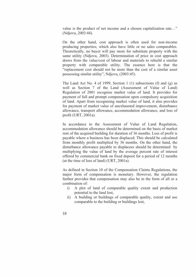
A theory is a set of explanatory statements connected by fact, logical arguments and by explicit and implicit assumptions (Miller, 2009). In case studies, theory helps to sharpen understanding of what is being studied and hence focus on who is to be contacted during data collection i.e. guides data collection. Theories also help to determine the level for generalization, (Yin, 1993). 3.2 The sustainable livelihoods framework
The sustainable livelihood framework (SLF) also referred to as sustainable livelihoods approach (SLA) was conceived in the 1980s and finally adopted by the Department for International Development (DFID) in 1997 as a strategy for pro-poor policy intervention. The framework argues that the success of any development intervention that touches the livelihoods of the people requires an understanding of the underlying conditions that supports the livelihoods. Without such an understanding, negative results from such interventions will not be news. Therefore, the Sustainable Livelihoods Framework postulate that an understanding of what comprises and supports the livelihoods of the people should be an entry point for the success of interventions into the respective livelihoods in the peri-urban areas.

24
3.2.1 Livelihood defined Livelihoods represent the multiple ranges of activities that households6 engage into in order to ensure their survival and improved well-being, Rakodi, (2002). The definition of livelihoods comprises the capabilities, assets (material and social resources) and activities required for a means of living, Rakodi (2002) and Chambers and Conway, (1992). Assets, both tangible and intangible comprise an important basis from which households derive and meet their consumption and economic necessities, coping with uncertainties and responding to new opportunities, Tadesse (2010). A livelihood is said to be sustainable when it can cope and recover from shocks and stresses and maintain or enhance its capabilities and assets both now and in the future, while not undermining the natural resource base (Solesbury, 2003), Knutsson, (2006), Rakodi, (2002) and Chambers and Conway, (1992). The livelihoods framework has identified five aspects that characterises livelihoods, whose understanding is important for successful intervention into the livelihoods of the people. These include the assets (human capital; social capital; natural capital, physical capital and financial capital), transformation structures and processes, vulnerability context, livelihood strategies and outcomes which affects the poor people lives, Rakodi, (2002) and Periperi and Oxfam, (2002). It is therefore the interest of this study to explore these theoretical positions using the peri urban livelihoods. 3.2.2 Assets According to Rakodi, (2002), Meikle et al, (2001) and Kombe, (2010), assets (tangible and intangible) held by a household and the capability of the household to transform the assets into a living denote the ability (of the household) to avoid or reduce vulnerability. As noted by Rakodi, (2002) and Periperi and Oxfam, (2002), land, housing, livestock and social capital seems to be the drivers of livelihoods in the peri urban context. These will be explored in this study. What matters in human capital (as an asset) is the ability to work i.e. sale of labour (which mostly depend on having a health), level of education and skills possessed. According to Rakodi, (2002) social capital is defined in 6 A household could be a person or co-resident group of people, contributing or benefiting from a joint economy i.e. they live under one roof and eat together (Rakodi, 2002:7)

25
terms of social networks of reprocity among households and between households and the community. Through social capital, households or communities can have access to loans, child care support, food and accommodation which could have otherwise being difficult, especially among the poor. Social capital does also include neighborhood-based groupings, gender and age based networks, political-based networks, religious and ethnic linkages and associations, savings and credit groups. Drawing from this, social networks seem to be important as vehicles through which members can access information on opportunities (such as job availability) and problems such that they grasp the opportunities and/or avoid the problems. Adopting this definition, this study will further follow it up especially when contexualising livelihoods in the case study area. The relationship between the livelihood assets, transformation structures and processes and the vulnerability context is presented diagrammatically in Figure 3.
Fig
ure
3.1
: S
usta
inab
le L
ivelih
ood
s F
ram
ew
ork
Sourc
e: A
dap
ted f
rom
Rak
odi (2
002).
N
ote
s on t
he
figure
: Both
ext
ernal
fac
tors
(se
aso
nal
ity
etc)
and p
olic
ies
and law
s ac
ts o
n t
he
asse
ts u
pon w
hic
h
house
hold
s dep
end for
thei
r liv
elih
oods.
Dep
endin
g o
n t
he
outc
om
es,
house
hold
s m
ay r
esort
to c
erta
in k
ind o
f st
rate
gie
s ei
ther
to b
ette
r th
eir
lives
or
cope
with t
he
shock
s/st
ress
es;
the
outc
om
es o
f w
hic
h c
ould
be
eith
er p
osi
tive
or
neg
ativ
e.
LIVELI
HO
OD
S A
SSETS
�M
ore
in
com
es
�In
crea
sed
wel
l-bei
ng
�Red
uce
d
vuln
erab
ility
�
Impro
ved
(food)
secu
rity
�
More
su
stai
nab
le
nat
ura
l re
sourc
e
bas
e
LIVELI
HO
OD
O
UTCO
MES
VU
LNERABIL
ITY
CO
NTEXT
�SH
OCKS
�TREN
DS
�SEASO
NALI
TY
TRAN
SFO
RM
ING
STRU
CTU
RES A
ND
PR
OCESSES
STRU
CTU
RES
�Le
vels
of gove
rnm
ent
�Pr
ivat
e se
ctor
�
Law
s �
Polic
ies
�Culture
In
stitutions
PRO
CESSES
Key:
H =
Hum
an C
apital
S =
Soci
al C
apital
N
= N
atura
l Cap
ital
P =
Phys
ical
Cap
ital
F
= F
inan
cial
Cap
ital
P
H
N
F
LIVELI
HO
OD
STRATEG
IES
S

27
According to Meikle, (2002) and Phillips, (2002), social networks are stronger in peri urban areas than in urban areas; and constitute a key asset for survival. Social networks can work beyond the poor families by involving wider networks between the poor and non-poor families and are quite helpful in reducing vulnerability especially during times of crisis. Often, people tend to rely on it on the absence of other assets. Rakodi, (2002) and IFAD, (2006) noted that physical capital, which entails land, livestock and housing is also an important in the peri urban context as it support agriculture for food production, shelter, income and social identity. It also provides support for other assets such as housing and animal keeping to develop. In the peri urban context, land is reported to play an important role into the livelihoods of the people as a source of food, shelter, income and social identity. As noted by IFAD (2006), land yields both economic, environmental and political benefits. Therefore, access to and use of land is an important aspect to peri urban households. In respect the preceding discussion, I argue that use and ownership of land as well as the locational aspect of the land are important aspects for survival and prosperity of peri urban households. Land is not only used as a source of food and shelter, but also as an asset that can be exchanged for value through selling to raise income to carter for other needs such as pay school fees, pay for medication. As argued by Payne, (2002), even in the absence of formal cadastre survey which is quite common in informal areas, land can still be used as a collateral for a loan through informal arrangements. This is mostly guaranteed through social recognition of long term occupation and use of land. The quote below further illustrates this:
“…in the African context land is both an economic and environmental resource and is central to sustainable livelihoods. It is also a social, cultural and ontological resource, connoting social identity. From the environmental perspective, land provides support to not only human livelihoods, but also all biotic matters. Land is also an enormous political resource as it defines power relations between and among individuals, families and communities under established systems of governance…” (IFAD, 2006:4).

28
Housing is both a physical and social asset. As a physical asset, housing is used for productive economic purposes especially through renting out or using the adjoining outer space for home-based income generating activities (Kachenje, 2005). As a social asset, housing is used for reproduction in addition to shelter. In a peri urban context, financial capital is not only closely related to, but also works together with human capital. It entails incomes that can be generated from sale of labour. Table 3.1 below summarises the above discussion on various assets depended upon by peri urban households to earn a living. Table 3.1: Assets commonly used by the peri urban households Assets Examples How can the asset be used to sustain life Human
Income Casual labour is a key asset for the urban poor to raise income to sustain life. Human resource requires having good health, skills and knowledge to make a living.
Natural Land Land is important assets for supplying food, incomes as well as employment opportunities (casual labour).
Physical
Housing Housing provides incomes from renting out rooms or the whole house as well as shelter and space for reproduction. The space adjoining the house can also be used productively as a home-based enterprise including small business such as tailoring, selling of food commodities/stalls, retail shops etc.
Livestock Livestock keeping is growing steadily in Dar es Salaam. Selling of animal or animal by-products (such as milk, eggs and skins/hides) supplements household incomes.
Social Social support mechanisms
In established communities, there are strong network of support and reciprocity within and between households and with communities. The networks are built on mutual trust. They are also a source of information; act as a media through which information about work availability (casual labour markets) can spread fastly to members.
Source: Adapted from Sheilah Meikle, Tamsin Ramasut & Julian Walker (2001). This study looks into the relationships between the various assets and their influence on livelihoods in the peri urban context. The three

29
aspects of the natural resources (mainly land, human capital and social networks) in relation to livelihoods are explored in this study. 3.2.3 Transformation structures and processes Transformation structures include institutions and actors at various government levels while the processes refer to the policies, laws, social norms, rules and incentives. Drawing from the foregoing, this study assumes that actors, institutions and the laws influence the nature of interactions, determine power relations, influence access to assets as well as the value of those assets; and hence an implication to the type of strategies that households can pursue to make a living. This also underscore an earlier argument by Rakodi, (2002) that the influence of policies, institutions and processes determines what options are feasible and also influence/affect people’s ability to manage their assets as well as withstand shocks and stresses. 3.2.4 Criticism of the livelihood theory Periperi and Oxfam (2002) have criticised the Sustainable Livelihood Framework (SLF) for raising expectations that are not met. They argue that while undertaking fieldwork enquiries, often all kinds of expectations are raised which unfortunately are not met. The framework is also criticized for romanticising about the poor; putting them at the central position and over-emphasising listening to their grievances. Periperi and Oxfam, (2002) caution that, these weaknesses need to be avoided, otherwise they may lead researchers to take the voices of the poor without critical reflections on them. They nevertheless caution that although the concerns of the poor are not all unfounded, some may be rooted on opportunistic tendencies, which results into illegal practices and claims. Given these positions, it will be of interest to follow up these critiques in this study and explore their authenticity. 3.3 Land delivery theory
Land delivery theory gives cognisance to evolving social and economic aspects that creates demand for land. Such demands may be by and for the public interest, private sector development or change of use. Thus, land delivery is concerned about how to make land available for various economic and social needs (FIG, 2010).

30
The theory works in consonance with issues of participation and transparency in land administration. It provides two options for making land available for either public or private use, namely market-based and human-based models. The market-based model deploys compulsory acquisition to make land available for various development purposes. The market-based model assumes that the operations of the forces of supply and demand would best determine the amount of compensation for one to part away with his/her property. However, in order for the market (approach) to be able to deliver land for urban expansion projects at the best price between the buyer and the seller, the land market must be effective and efficient (FIG, 2010). Despite this, FIG (2010) argues that market approaches have not been successful in developing countries because of a number of weaknesses including inability to define compensation levels, ill-approaches of determining compensation on the basis of pre-development rather than post-acquisition land uses. Besides, there are no efficient and transparent land markets, instead government-determined and regulated values rather than values obtained from open land markets. Other weaknesses include lack of up to date information base including property register i.e. most land and other properties are not registered/documented, thus they are more insecure. Ultimately, prices remains flawed as a basis to determine compensation levels. Lack of cooperation and participation among the occupiers and owners during removal/dispossession as well as inadequate communication between the government and the aggrieved individuals or households is also a constraint.
Drawing from these weaknesses, the land delivery theory by FIG advocates for the human-based approach, especially in situations where informal land markets predominates. According to FIG, (2010), the human-based approach seeks to protect the owners and occupiers of land from adverse impacts of acquisition by recognising entitlements of all displacees with or without legal rights i.e. including squatters and encroachers; giving resettlement assistance to all displacees and compensation for loss of both non-land and land-assets and rights; considering compensation at full replacement cost; giving relocation and livelihood assistance to physically displaced people; and enhancing
31
effective communication, consultation and enforcement to the affected community on the impact of the project before implementation. Reflecting the land delivery theory in this study, one of the possibilities is that should affected households be fully compensated (at full replacement cost); likewise be informed/consulted and well informed of the project impacts; they would be prepared not only to confront the outcomes, but also take part in shaping the implementation process as well as suggesting alternatives to improve the implementation process. Furthermore, the inadequacies of the market approach associated with unfair compensation, resistance by households, non-consideration of the social sustainability of the affected people, and lack of consideration for long-term benefits for the affected community, will be avoided. 3.4 The concept of urbanisation
Discussion on urbanisation is informed by two main concepts namely the “level” and the “rate” at which it occurs, UN Habitat, (2003). As noted by Kyessi (2002), while the level of urbanisation refers to the proportion of the total population that is living in urban areas, the rate of urbanisation refers to the speed or percent at which it is urbanising. Likewise, it is also associated with push and pull factors that determine movement of people from rural to urban areas. Further, UN Habitat noted that urbanization in Africa is moving from city-based to region-based configurations i.e. peri-urbanization, meaning that there is growth and expansion outwards i.e. more spatially. In the process of spreading out, it engulfs surrounding rural land and adjacent towns, UN-Habitat, (2009). Growth/overspills towards the peri urban areas are also a result of harmful growth patterns experienced in the cities, likewise of land and degradation of their physical structures. Given the different characteristics of urbanisation which also applies to the Tanzanian context, urbanisation is taking place without parallel economic growth. Trends suggests that higher levels of urbanisation are unlikely to be experienced in Wazo-Mivumoni in the near future, however the rate of population increase mostly from natural causes i.e. birth rates and in-migration from the regions and nearby urban areas is
32
quite evident. This underscores manifestations of the shift from city-based to region-based urbanisation trends, also referred to as peri urbanisation. It is within these contexts that the concept of urbanisation is seen in this study. 3.5 The concept of participation
Toker (2007) and Hamdi (1991) defined participation as the process of involving people, professionals, families, community groups and government officials in social and physical development of the environment they live. Relating it to power and decision-making, Arnstein (1969) defined it as redistribution of power to enable the have-nots, who are often excluded from political and economic processes, to take part in determining how information is shared; goals and policies are set; resources are allocated; programmes operated. Further, in his paper ladder of citizen participation, Arnstein identified eight levels of participation namely manipulation, therapy, informing, consultation, placation, partnership, delegated powers and citizen control. These are further grouped these into three main categories as illustrated in Figure 3.2. The objective of manipulation and therapy is not to enable people to participate in planning, but rather cure participants. Informing and consultation only allows the have-nots to hear and have a voice i.e. can hear and be heard, however they are devoid of powers to ensure that their views will be heeded by the powerful, as such there is no assurance of changing the status-quo. Placation is a higher level tokenism where the have-nots can advice but the rights to decide remains with power holders. Partnership, delegated powers and citizen control gives them increased degree of decision-making. Partnership enables citizens to negotiate and engage in trade-offs with power holders. With delegated powers and citizen control, the have-nots spear heads decision-making or attain full managerial power.

Figure 3.2: Eight rungs on the ladder of citizen participation
Figure: (Adopted from Arnstein, 1969) In this study, the concept of participation is understood as a shared process where both the residents, professionals, government officials and politicians jointly take efforts not only in the implementation of either land use plan or development project, but also a situation where residents are consulted and involved right from the early decision making processes. Such a shared process should enable the interest of the marginalised groups, who are devoid of political and/or economic power, to be accommodated in the project being implemented, likewise be able to influence decision and share the outcomes (either positive or negative) of a decision reached earlier.
8 Citizen control
Delegated power
Partnership
Placation
Consultation
Informing
Therapy
Manipulation
7
6
5
4
3
2
1
Citizen power
Tokenism
Non-participation

34
3.6 Relation between theoretical components and
peri urban livelihoods
The Sustainable Livelihood Framework underscores the need to understand the livelihoods of the people prior to making an intervention. The peri urban areas have often become the receiving end of the overspills arising from the urbanisation process taking place in the urban areas. As that is the situation on one hand, on the other, livelihoods of the peri urban people mostly depends on five assets namely the human resource, land, animals, housing and social networks. Both the quality of the human resource; the type of and use of assets at the disposal of households; the laws, policies and regulations; and respective institutions are important to influence livelihoods either positively or negatively. Not only the presence of these attributes is important, but mostly the interplay among them is what determines the level of vulnerability. Meikle, (2002), and Periperi and Oxfam, (2002) defined vulnerability as insecurity or threats to livelihoods and assets which can be caused external factors such as seasonability changes, droughts, economic decline as well as implementation of unfavourable policies. The SLF postulates that, if these factors act unfavourably on the assets (land, human resources and social networks), insecurities are likely to happen. Furthermore, insecurities lead to low resilience amongst households and individuals, weakening their capacity to mobilise assets to exploit opportunities as well as results to inability to resist, absorb or recover from shocks and stress. Drawing from the foregoing, an intervention informed by thorough understanding and appreciation of the livelihoods of the people, will most likely yield positive results; the opposite is also true. Success or failure of the interventions may also be caused by factors outside the control of households but which have a direct bearing on them. These are the laws, policies and regulations as well as the respective institutional levels. The argument here is that if the formulation of the laws and the implementation process are just; and also involves the residents, interventions are likely to succeed without disrupting livelihoods; and the opposite is likely true.
35
Referring to the Tanzanian context, and specifically land acquisition for urban expansion, the Ministry of Lands, Housing and Human Settlements Development (MLHHSD) is vested with policy formulation, guidance and control while Local Government Authorities (LGAs) are not only directly responsible for the day to day implementation process and service delivery, but are also supposed to foster participation of residents in development activities and ensure social-wellbeing URT, (1982a) and URT, (1982b). In order to ensure this, it is assumed in this study that not only that the laws should be commensurate with the needs and aspiration of the people, but also requires commitment, diligent and adherence to professional ethics among those charged with mandates to implement and monitor progress. The SLF argues that, if there is good understanding of the assets at the disposal of households and the role such assets play on their livelihoods; and that the laws, policies and regulations are favourable to the given context; and that those charged with implementation mandates acts rationally, intervention into livelihoods may not result into undesirable outcomes. Figure 3.2 diagrammatically present the relationship described above. The above discussion examined the theoretical underpinnings and concepts that underlie livelihoods of the peri urban households and the relationships between them, as either sustaining or frustrating livelihoods. The research design that was adopted to undertake the research is presented in the next chapter, providing a link between theoretical positioning and the empirical basis of the research.

Fig
ure
3.2
: C
oncep
tual Fra
mew
ork
for
this
stu
dy
Urb
an
expan
sion
Com
puls
ory
la
nd
acquis
itio
n
Tra
nsf
orm
atio
n
stru
cture
s an
d
pro
cess
es
Ass
ets
(support
ing
per
i urb
an
livel
ihoods)
Unfa
vora
bly
(af
fect
th
e as
sets
)
Peri u
rban
as
sets
Peri u
rban
liv
elih
oods
Nee
d for
land Pe
ri u
rban
ar
eas
Fav
ora
bly
(af
fect
the
asse
ts)
�La
ws
attu
ned
to t
he
nee
ds
of th
e peo
ple
, �
Appre
ciate
peo
ple
’s
asse
ts a
nd t
he
role
they
pla
y in
thei
r liv
es,
�Ju
st,
fair a
nd
tran
spar
ent
pro
cess
, �
Aw
aren
ess
crea
tion a
nd
par
tici
pat
ion o
f re
siden
ts
in p
lannin
g a
nd
imple
men
tation,
�Res
ponsi
ve a
nd
acco
unta
ble
inst
itutions
�La
ws
not
attu
ned
to t
he
nee
ds
of th
e peo
ple
, �
Lack
of ap
pre
ciat
e peo
ple
’s a
sset
s an
d t
he
role
they
pla
y in
thei
r liv
es,
�U
nju
st a
nd o
paq
ue
pro
cess
, �
Lack
of aw
aren
ess
crea
tion a
nd n
on-
par
tici
pat
ion o
f re
siden
ts
in p
lannin
g a
nd
imple
men
tation,
�Ir
resp
onsi
ve a
nd
unac
counta
ble
in
stitutions
Enhan
ce
or
dis
rupt
livel
ihoods

37
4. RESEARCH DESIGN AND STRATEGY
In this chapter, the research design adopted to carry out the research selection of the case study area, methods adopted for data collection and analysis are discussed.
4.1 Research design
Yin defines a research design as the logic that links empirical data to the study’s initial questions and ultimately to its conclusions i.e. a logical plan to get from here to there. Here means the initial set of questions to be answered and there means the conclusions. Between here and there major steps including data collection and analysis are found. The main purpose of a research design is to avoid a situation where the evidence collected does not address the initial research questions, (Yin, 1993). Research design is also conceived as the arrangement and organisation of data collection and analysis methods to fulfill the purpose of providing information necessary to derive explanation to the research questions, (Kothari, 1992). Drawing from these understandings, this research has adopted research questions to guide its operationalisation. The unit of analysis is yet another component of a research design. Decision on the unit of analysis is determined by the nature of study questions. The unit of analysis constitutes the substance of the study on which the researcher wants to be able to say something about at the end of the study, Patton, (2002). Accordingly, units of analysis could be individual people, clients, students, programmes, neighborhoods, communities, cities, states, cultures or nations (in case of international programmes). Different types of units of analysis requires different kinds of data collection methods, different focus for the analysis of data, and also a different level at which statements about findings and conclusions can be drawn. On these posits, the unit of analysis for this study is the livelihoods of peri urban households within a spatially and administratively defined entity of Wazo-Mivumoni in the peri urban part of Dar es Salaam.

38
The fourth and fifth components namely linking data to propositions and criteria for interpreting findings are less developed in qualitative researches, contact summary sheet and case analysis meeting, which are advocated as available options for linking data to propositions, were used to analyse data collected from the case study. 4.2 Research strategy
The need to deploy a research strategy derives from the fact that the universe is a complex system and so are researchable objects; thereby calling for a kind of a strategy to direct scientific investigation. There are several types of research strategies namely case studies, surveys, history, experiments and archival analysis. However, the choice of a research strategy is not accidental. It is informed by three main factors namely the type of research questions posed; extent of control the researcher has over the actual behavioral events and the degree of focus on contemporary events (Yin, 1993). Drawing from the nature of the research questions, case study research strategy was adopted. A case study is defined as an empirical inquiry that investigates a contemporary phenomenon within its real-life context, especially when the boundaries between phenomenon and context are not apparent, Yin, (1993). Patton, (2002) associate a case with what is expected of it i.e. capturing its complexity through detailed interaction with its context, studying and understanding of its particularity and complexity. 4.3 Justification for adopting case study strategy
Case study strategy with the subfield of purposive sampling was adopted in this research in order to pick an information rich case. The choice of this strategy was influenced by the nature of the research questions posed. Case study comprise one among several ways of administering social science research and is normally preferred when the questions of how or why are posed; and where the investigator has little control over events and variables being investigated i.e. they are of contemporary nature within some real-life context; and where there is need to retain the holistic meaning of the real life events (Yin 1993). The research questions in this research are both exploratory and descriptive in nature i.e. how and what questions. The livelihoods of the people represent a contemporary situation which exhibit little control of

39
the events. Both these conditions (contemporariness and little control) are met in case study. Furthermore, case study has an advantage over the other strategies because it can deploy multiple evidences which is not often the case in other strategies. It also has the ability to deal with a variety of evidence such as documents, artifacts (which are in the domain of survey and archival analysis), interviews and observations. As such, case study cope with managing typically distinctive situations comprising many variables, uses multiple sources of evidence (that calls for triangulation), and built on prior theoretical propositions. Leo, (2009) argues that case study, can be a tool for testing received wisdoms, and may even generate new theory, provided they serve as an effective test of the truth. 4.4 Case study area selection
A three-level devised criterion was adopted to select an appropriate case study area. According to Patton (2002), criterion sampling for case study selection pick all cases that meet some criterion in a strategic and very purposeful manner. Qualitative inquiry has the potential of studying few or even a single sample in depth contrary to quantitative inquiries whose confidence levels of generalization (from a sample to a larger population) is enhanced by studying larger samples randomly selected (probability-based random sampling). Despite this, Yin (1984) had criticised case studies as being too long, difficult to conduct and producing a massive amount of documentation. However, Patton, (2002) dismissed this critique arguing that factualness in respect of clear documentation of the various perspectives, interests and realities enhances qualitative approaches. In view of this, a three-level criterion was devised and used to guide the selection of cases for in-depth studies. 4.4.1 First level criterion The focus here was to select an area from the peri urban areas. As shown in Annex 2, Dar es Salaam comprised of 76 Wards i.e. 24, 22 and 30 in Temeke, Ilala and Kinondoni Municipalities respectively. Using the definition of peri urban areas presented in section 1.2. Likewise interviews with Planners as well as review of official documents from the three Municipalities of Dar es Salaam, 29 Wards

40
were selected. Of these, 9 were in Temeke; 11 in Ilala and 9 Kinondoni (See Table 4.1). Table 4.1: Selected Wards under first level criteria TemekeMunicipality
Status Ilala Municipality
Status Kinondoni Municipality
Status
Vijibweni Mixed Kinyerezi Mixed Kibamba Mixed Kibada Mixed Pugu Mixed Kunduchi Mixed Tuangoma Mixed Chanika Mixed Bunju Mixed Chamazi Mixed Ukonga Mixed Mbezi Mixed Mjimwema Mixed Tabata Mixed Goba Rural Somangira Peri Urban Segerea Mixed Mbweni Rural Kimbiji Peri Urban Kiwalani Mixed Wazo Mixed Pemba Mnazi Peri Urban Kipawa Mixed Kwembe Mixed Kisarawe II Peri Urban Kitunda Mixed Mabwepande Mixed
Msongola Mixed Vingunguti Mixed
Source: Pilot Survey in Dar es Salaam, (September-October, 2010) Given time and resource limitation, it was not easy to study all the 29 Wards in detail; yet not all of them captures the elements of compulsory land acquisition that the study want to investigate. Thus, there was a need to devise a second level criterion to trim down the number of Wards to remain with only those which are information rich in respect of the focus of the research. 4.4.2 Second level selection criterion In line with the focus of the research which is land acquisition for urban expansion, there was a need to capture this aspect. Therefore the second level criterion was devised, focusing on areas where compulsory land acquisition for urban expansion had occurred. A time frame starting from 1999 was also considered because it is when the new Land Act No. 4 (of 1999) was introduced in the country. Among others, the Act recognized land value for bare land contrary to the years before where land was considered to have no value except for the unexhausted improvements made on it. Application of the second level criterion reduced the number of Wards from 29 to 12 as shown in Table 4.2 and Map 4.1. The Wards that qualified at this level include Kibada, Tuangoma and Mjimwema (in Temeke Municipality); Kinyerezi and Chanika (in Ilala Municipality);

41
and Kibamba, Kunduchi, Bunju and Mbweni (in Kinondoni Municipality). Table 4.2: Selected Wards after application of second level criterion TemekeMunicipalCouncil
Reason forselection
Ilala MunicipalCouncil
Reason for selection
KinondoniMunicipalCouncil
Reason for selection
Kibada One of the 20,000 Plots Project
Kinyerezi One of the 20,000 Plots Project; also resettlement site for the people affected by Songosongo gas pipeline and electricity main transmission line
Kibamba Selected because it was designated as Satellite Town (Luguruni)
Tuangoma As above Chanika One of the 20,000 Plots Project
Kunduchi It was one of the 20,000 Plots Project
Mjimwema As above Bunju As above Mbweni As above Mabwepande One of the
20,000 Plots Project and Mabwepande Resettlement scheme
Wazo One of the 20,000 Plots Project (Mivumoni)
Kwembe As above
Source: Pilot Survey in Dar es Salaam, (September-October, 2010) The 12 Wards selected under the second level criterion were still impractical for in-depth studies considering time and resources available. It therefore called for adoption of a third level criterion to pick a case that will be information rich and hence subject for in-depth studies. 4.4.3 Third level selection criterion In view of the above discussion, a third level criterion with six attributes was developed to help to pick an information rich case from the 12 wards. The attributes that the selected Ward should possess were:
a) Should be habited;

42
b) Exhibit diverse economic activities capturing competing interests between housing, farming and businesses, animal keeping, gardening, small retail businesses, sand extraction activities, casual laboring;
c) Depict existence of the different social classes of people such as rich, poor and middle income categories;
d) Having many households and individual people relocated within the area after land acquisition for public use in the former settlement;
e) With averagely more than six years time-lapse from the time acquisition was done to the time when compensation was paid; and
f) With a fast growing housing sector – depicting various housing conditions which will help to shed light on the socio-economic well-being of the households.
Justification for selected attributes for third level criterion Investigation using the above attributes/issues helped to gauge the feasibility of the case. Habited area and economic activities would help to determine how vibrant the area was. A settlement with high population is likely to have more economic activities. This provided the actual substance for this study. There should be people living in the area, and it is necessary that they should have owned land and lived in the area before land was acquired. This would help to understand the livelihood activities that supported their lives. Land acquisition to allow implementation of a land use plan would no doubt cut through and disrupt the established livelihoods of the people. This is what constitutes the substance for investigation by this study. This provides the opportunity to map the nature and dynamics of the varied livelihood strategies and opportunities which were also one of the prime aspects that this study aims to investigate. On the other hand, compulsory land acquisition by the government (for implementation of a land use plan) was quite important as it sets the whole process into motion i.e. land acquisition, compensation and relocation. The implementation of a land use plan comprises laws, regulations and various institutional levels to oversee implementation (i.e. transformation processes and structures respectively). Along these lines of argument, the Wards of Mjimwema and Kibamba where no

43
land acquisition and relocation has taken place were dropped. (See Annex 2). Time time-lapse from when land was acquired to when compensation was paid was meant to capture time for re-establishing life after land was acquired and life got disrupted. As the study aims to investigate the livelihoods-related impacts resulting from land acquisition, it was necessary to provide for a time element. A minimum time lapse of six years was adopted. Drawing on plot development conditions for planned areas, one is required to finish construction of a house three years since when the building permit was granted. An assumption was made here that one will need additional three years to settle down and re-establish livelihood activities after completion of construction work. This time-span was adopted on the assumption that households would have adopted new ways of life, likewise opportunities and strategies to sustain livelihoods. On the other hand, the aspect of relocation is important. Relocation of affected people within the Wards offered a possibility of reaching them for interview. Where relocation was outside the Wards i.e. distant places, these areas were disqualified in the case study selection. Housing development was also used because it complements the dynamics of economic activities and social-economic status of the residents. However, an emphasis was placed on settlement with high intensity of housing development which gives an indication on the extent to which the settlement has consolidated. The concern here was to get a densely built area which had the possibility of being information-rich. Operationalisation of the third level criterion was made possible by inventorising all the 12 Wards using the attributes presented above. Discussions with Ward and Mtaa leaders as well as residents in respective settlements were made to compliment the inventory. Observation and recording for later comparison and analysis were also done. Results of the inventory The two Wards of Mjimwema and Kibamba did not qualify for further screening because neither land acquisition nor relocation of households had taken place there. The analysis of information collected was grouped into four categories of qualification as presented in Annex 2.

44
Category 1 included old projects that had up to 8 years since compensation, acquisition and relocation took place; including presence of many households that were affected. Under this category, four Wards of Chanika, Wazo, Kinyerezi and Kunduchi qualified. The two Wards of Toangoma and Mbweni qualified under category 2 because there are only a few of the relocated households still living in the area to date. Furthermore, they are moderately old projects of between 6 and 7 years since land was acquired and relocation took place. Kibada qualified under category 3. Although many of the affected households are still living there to date, it is a recent project; hardly 2 years old since land was acquired and relocation took place. The other three Wards of Kwembe, Bunju and Mabwepande qualified under category 4. These Wards combine characteristics of both old and recent projects; also only a few of the affected households could be found in these areas. These reasons apart, socio-economic dynamics and housing activities are fairly modest. The use of time span as one of the indicators to select a case study area may be insignificant to warrant selection mainly because of the narrow gap, for example 8 years for category 1 and between 6 and 8 years for category 2. In order to overcome this deficit, the aggregated result after application of the other indicators (i.e. number of relocated households, relocation status either within or outside the Ward, socio-economic dynamics and housing conditions) was used to complete the selection process. With these results, Wazo Ward was selected because it exhibit most of the attributes under criterion three thus emerging top of the 12 Wards.

Map
4.1
: W
ard
s s
ele
cte
d for
Pilo
t S
urv
ey
Sour
ce: D
ata
from
Sur
vey
and
Map
ping
Div
isio
n (2
011)
, Dar
es S
alaa
m; a
nd u
pdat
ed fr
om fi
eldw
ork
data
(Mar
ch-A
ugus
t, 20
11).

46
4.5 Data collection methods
In this study, data was collected from primary and secondary sources. Secondary sources entailed review of published literature on land acquisition for public use. Likewise, government reports including laws, policies, regulations and guidelines were reviewed. On the other hand, primary data collection in Wazo-Mivumoni was done using semi-structured questionnaire to guide detailed interviews both at household (land owners) and government levels, see Figure 4.1. Figure 4.1: Research design process
Literature review
Identification of the research issue
Theories � SLF � Land delivery
Areas for further research
The research questions and objectives
Research design, strategy and unit of analysis
Data collection and analysis
Conclusion
Generalization

47
Prior to household interviews, a meeting was held with Mtaa leaders and thereafter a meeting with Mtaa residents to get a first impression of the socio-economic status of the households as well as an overview of the land acquisition process. The discussion with Mtaa leaders was essential to identify the extent of people affected by implementation of the 20,000 plot project. As the primary focus was to combine qualitative and quantitative approaches, first structured questionnaire focusing on critical/key issues were administered (see Appendix 1). These aimed to generate social economic data at household level as well as personal experiences on the implementation of the urban expansion project. At the settlement level, key informants and community leaders were also interviewed so as to get a deeper understanding of the issues, particularly livelihoods activities of the people. Although they can also be biased thus demanding the investigator to maintain a critical perspective on the information they give, Key Informants should be picked among people possessing sufficient knowledge about the setting of the inquiry. Key Informants are also important to enable the researcher get a higher understanding of what is happening within the subject of inquiry which s/he would not otherwise capture. Despite this, KI needs to be well informed about the purpose and focus of the inquiry, the issues and questions under investigation and the kind of information that are needed and most valuable (Patton, 2002). On the other hand, official interviews were done with land officers in Kinondoni Municipality where Wazo-Mivumoni is located. Others in the list of official interviews are project officials for the 20,000 Plots Project at the Ministry of Lands, Housing and Human Settlements Development and the Chief Government Valuer. Combination of multiple sources of data and varied respondents helped to ensure triangulation of the information collected. As argued by Leo, triangulation helps to confirm all simple facts, as well as causal, contextual and analytical knowledge that has been drawn from more than one source so as to clear doubts and thus justify the case as a good one (Leo, 2009). This was operationalised through posing key questions to more than one set of respondents for example government officials and local leaders as well as key informants. Feeding meetings and extra interviews were also held after the first draft report was ready. Figure 4.1 summaries the research design process.

48
4.6 Data analysis
In qualitative (case) studies, it is advised that its analysis should go concurrent with data collection rather than waiting till all data has been collected, Patton, (2002). Data analysis concurrent with data collection has the advantage of collecting new data to fill in gaps. It gives the researcher an opportunity to think over the existing data forward and backward and devise strategies to collect new, often better data. Mathew and Huberman, (1994), note that data analysis starts from the early stages of data collection in the field. Data analysis while all the data has been collected has the danger of limiting collection of new data; also restrain re-orientation/reformulation of new strategies necessary to capture new data emerging during data collection. In this research, contact summary sheet, case analysis meeting and coding were used to analyse data. In contact summary sheet, questions often focussing on areas/issues not adequately covered in the preceding interviews or new issues suggested by respondents are tactfully designed for the subsequent interviews. In case analysis meeting, both the principal researcher and the research assistants sit and discuss, summarize and record the status of the case being investigated. The meeting is guided by a series of questions, the responses to which are recorded. On the basis of questions asked and clarifications provided, the researcher gathers knowledge which can be helpful to make specific plans to enable collection of new data or even revise pre-determined codes meant to guide data collections (Mathew and Huberman, 1994). In administering contact summary sheet entailed formulation of questions that helped to review the interviews already accomplished. The questions were set out in such a way that they help to illustrate main points that emerged from the interview. The essence was to capture main issues that emerged in the interview; identify issues that were adequately answered; which ones were suggested by the respondent(s); and which ones demanded more efforts in the forthcoming interviews. Contact summary sheet was used in this research during data collection in two ways. The first instance was while the household interviews were going on. After the first three days of interview, I, the principal and

49
research assistants sat together and reviewed the data collected. Specific interest was directed on a number of issues that seemed to require more efforts to get clear information. Also new areas not previously captured in the household questionnaire were identified. These issues include:
a) More data/information on how the sensitisation was carried out prior to project inception. During the review, unclear responses were given regarding rights of the residents and obligations of the project following land acquisition;
b) Items and extent and compensation paid. The information at hand after three days of interview indicated that many of the affected residents were not sure if their land was compensated or not; and
c) Verification of the valuation results. Majority of the households explained that valuation exercise was technically undertaken by the experts/valuers who jotted down what they found on the plot without leaving any copy of what they recorded.
In order to facilitate data extraction, a guide was developed and used to ease systematically ease the process. It also provided an entry point for coding and eventually analysis of the same. Figure 4.2 provide an extract of the guide that was developed and used for data retrieval and analysis. Figure 4.2: A guide to cluster information from questionnaire
Source: Own construct basing on fieldwork information
The categories were: A = Good/flat land not affected by community services; B = Good/flat land but affected by community services; C = Areas wholly located in steep slopes; D = Areas where owners have planned and surveyed them; E = Good/flat land but extending to the steep slopes.
1. Number of the interviewee: 16M 2. The main categories of the interview: B (Good/flat land but affected by
community services) 3. Compensation:
A: i) Crops compensated, ii) House/building(s) - COMPENSATED, iii) Land - NOT COMPENSATED, iv) Transport allowance - NOT COMPENSATED, v) Disturbance allowance NOT COMPENSATED
B: Not moved/still leaving in the plot/shamba/area C: No alternative plot provided D: There are complaints, but don’t know where to channel them
4. Recording: “15M- Said Mikidadi-29.03.2011.MP3”
50
Data was retrieved from written field notes and recorded transcripts. In initial analysis stage, categories were developed from it which was then labelled (coded). For example, respective questionnaire were organized into various categories, say for-example, the household questionnaire was sub-divided into six categories namely spatial growth dynamics; access to and use of land prior to formal planning; the process of securing land for public use; on-set of formal planning; land acquisition and compensation, stress due to loss of livelihoods and efforts to recover from stress that allowed systematic data collection. In essence, this provided a stepping stone for developing codes and ultimately coding upon which meaning were drawn along the pre-determined categories. As argued by Mathew and Huberman (1994) coding is about dissecting meaning from field data, often chunk of words, phrases, sentences or whole paragraph. In this study case analysis meeting was held in the case study area prior to data collection. The meeting was held on 15th March 2011; and was attended by 20 participants including the Mtaa Chairman; two members of the Mtaa government, residents of the area and myself. The meeting was essentially meant give the researcher an opportunity to introduce the study and interest represented. After clarification to these concerns, the participants suggested ways to organise the interviews. Drawing from the outcomes of this meeting; I got a clue that was necessary to refine and focus my questionnaire to vividly capture issues that were connected to the project, capturing issues, actors and processes that actually happened on the ground. This apart, the meeting also helped to build rapport between me and the respondents for the interviews that ensued. 4.7 Judging the quality of a research design
The quality of a research design and hence any empirical social research can be ensured by four tests namely construct validity, internal validity, external validity and reliability with respective attributes as summarized in Table 4.3. Table 4.3: Case study tactics for validity and reliability tests

51
Tests Purpose Case study tactic Phase of research it can occur
Construct validity
Establish correct operational measures for the concepts being studied (really measuring what was intended to be measured)
Use multiple sources of evidence
Data collection
Establish chain of evidence
Data collection
Have key informants review draft case study report
Composition
Internal validity
Establish causal-relationship (used for explanatory or causal studies only – where certain conditions are shown to lead to other conditions)
Do pattern matching Data analysis Do explanation-building
Data analysis
Address rival explanations
Data analysis
Use logic models Data analysis
Externalvalidity
Establishing the domain to which study findings can be generalized
Use theory in single case studies
Research design
Use replication logic in multiple case studies
Research design
Reliability Demonstrating that the operations of a study can be repeated by another researcher, with same results
Use case study protocol
Data collection
Develop case study database
Data collection
Source: Adapted from Yin, (1993:34). There is always a danger of ending up with “subjective” judgments if care is not taken to develop sufficient operational set of measures. In order to ensure quality research design in this study, clear understanding of the contexts governing livelihoods of peri urban households was important so as to ensure that the data collected genuinely reflected the focus of the study. This was alternatively enhanced through clear definition of research questions and methods of data collection. Likewise, frequent checks in the form of dialoguing and sharing of information were conducted as the research was going on. It is also important to underscore here that these tests were applied throughout the course of undertaking the research. 4.8 Combining qualitative and quantitative techniques
Although this study is of explorative (qualitative) nature, quantitative techniques were also deployed to not only complement but also enhance the quality of the qualitative analysis. All household interviews were undertaken using semi-structured questionnaires, which made the

52
results mostly qualitative. However, statistics were worked out on the basis of total number of respondents contacted, and the responses were quantified in percents. Also visual graphics including tables and figures were used to illustrate/display the results. 4.9 Critiques against case study strategy
One of the critiques against qualitative approach deploying case study strategy is found within a philosophical debate of being subjective rather than objective, Patton (2002). In order to counteract this weakness, factualness was observed while undertaking this research. This was achieved through proper documentation of the various perspectives with respect to land acquisition from the side of implementers of the project and those affected by the implementation of the project; likewise interests among the different actors involved as well as realities pertaining on the ground. Case study has also been criticised for lack of credibility of its final outputs. It has been argued that case strategy does not follow systematic procedures, Patton (2002). In order to achieve credibility in this research, the field materials were revisited several times to discern meanings and categories. Likewise, extensive sharing of the research results among different professionals (planners, valuers and land officers, selected respondents from the project and key informants) as well as triangulation on methods and data sources was done.
This is how data was collected and analysed in this research. However, as observed Yin, (1993), the difference between the object of study and its context in contemporary qualitative research is very thin. Thus, it was necessary to not only collect data on the livelihoods of Wazo-Mivumoni households, but also try to understand its influencing context. As argued by the Sustainable Livelihood Framework, this understanding is necessary to enhance successful interventions. The next chapter explores livelihoods of the Wazo-Mivumoni households and its influencing context.

53
5. LIVELIHOODS IN WAZO-MIVUMONI
PRIOR TO 20,000 PLOTS PROJECT
The livelihoods of Wazo-Mivumoni households and its influencing context are discussed in this chapter. It traces the settlement growth trends and assets possessed by households prior to project implementation and explore the roles of those assets to enhance livelihoods.
5.1 Location of Wazo Ward and level of social service
provision
Wazo Ward is located in Kinondoni Municipality. It was initially Mtaa area within Kunduchi Wards up to March 2010. According to the 2002 National Population Census, Kunduchi had a total population of 75,575 people. Kunduchi covered 5,823.06 Ha (58,230,640m2). In order to ease administrative functions, Kunduchi Ward was divided into two Wards namely Kunduchi (itself) and Wazo in March 2010. Wazo Ward is comprised of seven Mtaa areas namely Wazo (itself), Salasala, Kilimahewa, Mivumoni, Kisanga and Madala. In an interview with the Ward Executive Officer7, it was noted that neither official maps indicating the Ward boundaries nor attempts to establish the total Ward population have been done. Wazo Ward is bordered by the old Bagamoyo (Ali Hassan Mwinyi) Road to the East, Goba Ward in the South, Bunju Ward to the North East and Mbezi Ward to the South East. The Ward covers 33,942,188 m2 (3,394.22 Ha). Out of the seven Mtaa areas comprising Wazo Ward, Kisanga and Mivumoni were among the Mtaa areas selected for implementation of the 20,000 plots project in Kinodoni Municipality. These two comprised the case study area for this research; and in this report they have been referred to as Wazo-Mivumoni.
7 Discussion with Mr. Shabani Kambi, Ward Executive Officer for Wazo Ward on 29th August 2011 at the Ward Office.
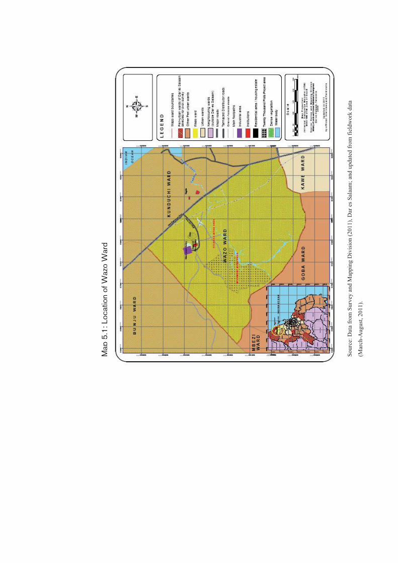
Map
5.1
:Location
of
Wazo
Ward
Sour
ce: D
ata
from
Sur
vey
and
Map
ping
Div
isio
n (2
011)
, Dar
es S
alaa
m; a
nd u
pdat
ed fr
om fi
eldw
ork
data
(Mar
ch-A
ugus
t, 20
11).

55
The Ward is still underprovided in terms of social and community services. It has over 15 secondary schools, 12 of which are privately owned and the remaining are government schools. There is also one privately owned teachers’ college as well as a day care centre. Water availability is still unreliable due to intermittent supplies causing long lines in the few water points within the ward. Reliable health service is still lacking in the Ward. Currently, there are two government dispensaries; one at Madala and the other one at Kisanga Mtaa areas. The Ward is fairly well accessible through gravel roads and footpaths that provide connectivity to the Bagamoyo road. For the purpose of this study, the two Mtaa areas of Kisanga and Mivumoni, also referred to in this report as Wazo-Mivumoni which comprise the case study area for this research are provide basis for the ensuing discussion. 5.2 Formation and growth of Wazo-Mivumoni
Wazo-Mivumoni started to receive big influx of people from various parts of the country from early 1960’s. Between 1991 and 2010, the area recorded the highest influx of people. Interviews with 77 households revealed that 58 percent of the people (45 out of 77 households) moved to the settlements between 1991 and 2000; while 22 percent settled in the area between 2001 and 2010, as shown up in Table 5.1. Table 5.1: The growth of Wazo-Mivumoni settlement S/Nr Period Number Percent 1. 1961 - 1970 2 3 2. 1971 - 1980 5 7 3. 1981 - 1990 7 9 4. 1991- 2000 45 58 5. 2001 - 2010 17 22 6. Don’t remember the year 1 1
77 100
Although Wazo-Mivumoni drew its populations from various regions of the country, almost 26 percent originated from Dar es Salaam (the capital city). A striking feature of the movement pattern of the present settlers in Wazo-Mivumoni is that even the immigrants despite indicating that majority originated from Dar es Salaam, none was a native of the area. Those originating from Dar es Salaam are also aliens who first settled in Dar es Salaam and other neighbouring settlements

56
including Tegeta before moving to Wazo-Mivumoni. Among the reasons that attracted people to settle in Wazo-Mivumoni include pursuit for livelihoods (68 percent); other reasons were living closer to relatives who had already settled in the area (14 percent); as well as those who were seeking a place to live after retirement from Public Service (12 percent), as shown in Table 5.2. Table 5.2: Reasons to settle in Wazo-Mivumoni S/Nr Reason Nr. Percent 1. Allocation by (Tegeta) village council during the
Nguvu Kazi agricultural campaigns of 1980s8 52 68
2. Living closer to friends/relatives already living in Wazo-Mivumoni
11 14
3. Search for place to live after retirement from public service
9 12
4. Search for residence close to place of work 4 5 5. Search for a new/different living environment 1 1 77 100
The large family size of most of the interviewed households by the time they moved into Wazo-Mivumoni indicates that they were not simply starters, but rather families that were already well established elsewhere in the city. This is supported by the fact that more than 87 percent of the interviewed households had above 5 members when they moved to Wazo-Mivumoni. 5.3 Access to land prior to implementation of the
20,000 Plots Project
Wazo-Mivumoni received large influx of people just before the 20,000 Plots Project was initiated. As summarised in Table 5.3, almost 56 percent accessed land through buying; 19 percent were freely allocated by friends or inherited from their parents. The rest got it either through allocation by village council (13 percent) or cleared the bush and occupied (12 percent). In the 1980s, rural Village Councils were mandated to allocate land especially under the operation Nguvu Kazi9.
8 For farming and also conducting petty trading 9 This was a slogan adopted by the government of Tanzania in the 1980’s to encourage unemployed people in urban areas to go back to the villages to engage

57
Those who cleared bush occupied land where there was hardly any development in the area. Table 5.3: Modes of accessing land in Wazo-Mivumoni Bought Nr Percent Buying 43 56 Inherited from parents and/or given for free by relatives/friends
15 19
Allocation by the village council (1/4 acre during the nguvu kazi campaigns)
10 13
Bush clearing 9 12 77 100
Analysis of the movement patterns in view of the fact that only a few households (14 out of 77) (� 18 percent) were living in the settlement before 1990; indicate that those who settled later mainly accessed land through buying or being given by friends and relatives. This further shows that most of the land parcelling and selling took place from 1990 onwards. This is also confirmed by the extent (amount) of land that was held by most occupiers before implementation of the 20,000 plots project. About 38 percent of the respondents (29 out of 77 households) owned below ¼ an acre of land; while 18 percent (14 out of 77 households) held land ranging from ¼ to ½ an acre. About 3 percent (2 out of 77 households) owned between ½ and ¾ of an acre; while 9 percent owned small sizes of land between ¾ and 1 acre of land (see Table 5.4).
in agriculture activities. Village councils were also mandated to grant these people portions of land to farm.

58
Table 5.4: Size of land held prior to the 20,000 plots project implementation
S/Nr Size of land Number Percent 2 ¼ acre and below 29 38 3 ¼ < * � ½ 14 18 4 ½ < * � ¾ 2 3 5 ¾ < * � 1 7 9 6 1 < * � 1¼ 1 1 7 1¼ < * �1½ 4 5 8 1½ < * � 2½ 7 9 9 2½ < * � 3 1 1 10 3 < * � 4 6 8 11 4 < * � 5 1 1 12 5 < * � 7 2 3 13 7 < * � 10 2 3 14 > 10 1 1
77 100
None held land measuring between 1½ - 2 acres These trends suggest that, as about 56 percent owned land parcels of less than ½ an acre; about 68 percent owned land parcels of less than one acre each. The study shows that almost three quarters of the households held land measuring one acre or less at the time the 20,000 plots project started; meaning that many were depending on the land to earn their livelihoods. The quotes below from two different households illustrate the foregoing:
“…On my piece of land I used to cultivate crops that were enough to keep me going for up to two or three months, without buying cereals or farm-related products (such as cowpeas, vegetables and pigeon peas) from the shops. I was keeping animals, incomes from which met my needs especially for food. They also provided a good source of income…” 10
Apart from being a source of food, land also supported access to shelter and thus promoting home-ownership. The interview with one household revealed the following:
10 Discussion with Mr. Matobo, F. Matobo (46 years ); at his residence in Kisanga Mtaa area on 23rd March 2011.

59
“…I planned to build my own house on the quarter acre of land I had bought in Mivumoni. The intention was to do away from rental accommodation hassles associated with rental accommodation. I bought that land so that I may have a place to settle/live and relax with my children…”11
The discussion above demonstrates that having a piece of land regardless of the size was quite important. The same piece of land was put to multiple uses, signifying that people’s attachment to the land was very central. Land also proved to be very critical in the sense that it was the base asset upon which other assets could find root and develop. 5.4 Assets held prior to implementation of the 20,000
plots project in Wazo-Mivumoni
Land, crops, housing and animals constituted the main assets possessed by households in Wazo-Mivumoni prior to implementation of the 20,000 plots project. Interviews in Wazo-Mivumoni indicate that about 94 percent (72 out of 77 interviewed households) drew their livelihoods from a combination of assets namely land, animal, crops and houses (Table 5.5). These assets provided food and income to the people. They also allowed social networks for mutual support in farming-related activities. Table 5.5: Assets held by households interviewed S/Nr Assets Nr Percent 1. Land; house; crops 41 53 2. Land; house; animals 12 16 3. Land; house; animals and crops 10 13 4. Land and crops 9 12 5. Land (only) 5 6
77 100
House ownership in Wazo-Mivumoni was equally important just as having crops. Both crops and house-ownership were in combination with owning a piece of land. Land supported house construction, likewise farming and animal keeping. 94 percent of the interviewed households owned both land; house, animals and crops. As would be 11 Discussion with Ms. Anna Mnyalape (32 years ); at her residence in Kisanga Mtaa area on 23rd March 2011.

60
seen later land was very fundamental to support the rest of livelihood activities. Only a small proportion (6 percent) owned only land. 5.5 Livelihoods of the households prior the 20,000
plots project
The livelihoods of the people in Wazo-Mivumoni prior to project implementation depended on combination of a number of assets (land, social capital, animal keeping, and houses) that they could mobilise. All the 77 interviewed households were engaged in more than one economic activity at a time (Plate 5.1 and Table 5.7). A common pattern was revealed that casual or seasonal activities were being undertaken in combination with activities such as agriculture and animal keeping.
Plate: 5.1: Livelihoods activities in Wazo-Mivumoni Before project commenced, 52 percent of the households were engaged in two main activities namely agriculture and animal keeping. These were the core livelihood activities around which other activities were jointly undertaken. Another 14 percent were engaged both in self employed activities12 and agriculture and animal keeping. 4 percent were formally employed, but were also involved in agriculture and animal keeping.
12 Driving, carpentry, tailoring and mechanics

61
Formal employment included working either in the nearby Wazo Hill Cement factory or in private security companies nearby settlements such as Mwenge and Magomeni. 26 percent were engaged in petty trading/small business activities in combination with agriculture, casual labouring, drivers and animal keeping. Only 4 percent were engaged in casual labouring without any other livelihood activities. Table 5.7: Economic activities prior to 20,000 plots project S/Nr Economic activity Nr Percent 1. Agriculture and animal keeping 40 52 2. Petty trading + [Agriculture and animal keeping] 20 26 3. Self employment ( tailoring carpentry,
mechanics) + [Agriculture and animal keeping] 11 14
4. Formal employment + [Agriculture and animal keeping] + driving
3 4
5. Casual labouring 3 4 77 100
Animal keeping as one of the core livelihood activities entailed keeping of domestic animals such as cows, goats, chicken, ducks and pigeons. Most of these were kept for cash (selling) and a source of food. Interview with one of the household’s head who had 8 acres of land and several animals and crops, underscores the same:
“…I had 24 goats; 1 cow; 85 chickens of local breed; about 400 chickens of exotic breed. Before the project, one goat was selling at TShs. 30,000/= (25 U$); one chicken at TShs. 7,000/= (6.0 U$); and one cow at around TShs 380,000/= (317 U$). My average income from sell of animal products per month was TShs. 28,000/= (23.0 U$)…”13
From the above discussion, it is obvious that livelihoods of Wazo-Mivumoni households depended on a combination of economic activities, most of which were anchored on the land. The nature of the economic activities also indicates that most of them were undertaken within the settlement because they were tied to the land held by the households. This means that not only the land matter in determining the
13 Discussion with Mr. Barnabas Robi (72 years); on 16th March 2011 at his residence in Kisanga Mtaa area.
62
livelihoods of the households in Wazo-Mivumoni, but also the settlement itself. 5.6 Social capital as a support to livelihoods
Core livelihood activities which were mainly on-farm were supported by a network of social capital practices. Social capital was instrumental in enhancing financial assets especially during emergencies; raising money to pay school fees or help during funeral or in development activities, labour contribution especially in tendering farms during the farming season or cash contribution. The following remarks by three different households illustrate the foregoing:
“…We had a network of social security fund where we used to donate money that was used to enhance social and economic support among members. We appointed a treasurer whose responsibilities were to keep the funds in safe custody as well as making payments to members who were in need of support from the group (such as those who had lost close relatives etc)…”14. “...We had a group that was mainly teaming up during farming season. A person whose farm would be cultivated prepared food and drinks which were taken after farming. The team rotated until all the members in the group have their farms cultivated...”15. “...We had an upatu16 group called upendo where we used to raise cash that was lended to members who were in need. We were ten people in the group and we were contributing cash ranging between TShs 10,000/= (8.0 U$) and TShs 15,000/= (12.5 U$) every 15th or 30th day of the month. The monthly collections was given to one
14 Discussion with Mrs. Emmanuel Aaron Komba (35 years); on 18th March 2011 a resident in Kisanga Mtaa area since 1987. 15 Discussion with Ms. Alima Ally Makumba ( 70 years); on 22nd March 2011, a resident in Kisanga Mtaa area since 1965. 16 Upatu is a Swahili word meaning social voluntary grouping where members donate either cash or labor to support one another on various emergencies such as farming, sickness, raising money to pay school fees etc.

63
member on a weekly basis. The rotation went like that untill all the members are covered...”17.
When people are displaced from such social environment where social capital was already practiced, they often lose the social networks and capital which might have taken several years or even decades to evolve and be accepted by most members. As we have seen above, such networks provide not only livelihoods but also provided social safety nets. Thus, social networks are very critical for especially low income households; and they take time to evolve and become functional. 5.7 Social networks and access to land
Although access to land in the case study area was mostly through buying (56 percent) and inheritance (19 percent); the role of social capital in the overall land-access path cannot be underestimated. As stated, about 19 percent of land access in Wazo-Mivumoni was facilitated by a relative or a friend who was already living there. Looking at the places of origin versus mode of accessing land of the present settlers, ethnicity seems to have played a positive role. Ethnicity seems to have facilitated access to land especially for migrants from areas such as Lindi, Rufiji and Kilwa (16 percent); from Tanga (9 percent) and (6 percent) from Kigoma and Kilimanjaro respectively. This defy a counter argument that such earlier settlers may shun away from fellow ethnic members because of un-readiness to shoulder an extra responsibility of supporting them to settle and establish life. Tracing this to modes of accessing land; it is evident that it helped new comers to easily access land through being given an advice, got short-term accommodation while adjusting to new life style in town or even being given land directly. The quotes below from different households who accessed land through social capital mechanisms further illustrate the foregoing:
“…I shifted to Dar es Salaam from Mkika village, Nginjo Division (Kilwa) in 1981. I shifted to try to earn a living in a new place. I had many friends and relatives in Dar es Salaam, and I pondered, why I shouldn’t I go there. After all, living in a big city like Dar es Salaam
17 Discussion with Ms. Asha Haji and Khadija Maulid Majengo; residents of Kisanga Mtaa area, on 22nd March 2011.

64
was everybody’s dream. So, in 1981, I shifted to Dar es Salaam where I first lived with the family of Mr. Hemedi Katipway, who was a close relative. In 1984 through the villagelization programme, I was allocated land measuring a quarter of an acre in Wazo-Mivumoni. Thereafter I constructed a temporary house and moved there…”18 “…I arrived from Tunduru in 1953 and first settled in Mtoni Mbagala where I was employed in a sisal estate owned by a Greek national. In 1974, I shifted from Mtoni Mbagala to Mivumoni. I was attracted to shift to Wazo-Mivumoni because my brother-in-law was already living here. My brother-in-law not only advised me to shift to Wazo-Mivumoni, but also gave me about eight acres of land from his big farm. Unfortunately I do not remember the year; but it was soon after the Villagelization Programme of 1974…”19
From these quotes, it is clear that ethnic relations played an important role to enable households to access land in Wazo-Mivumoni. A pattern is also noted that influence of social networks could be stronger in particular ethnic group than in others depending on how members in the group know each other. In Wazo-Mivumoni, stronger relations were noted among people hailing from the southern regions of the country. This fact supports the argument that social networks are anchored on trust. People hailing from particular area seem to know one another and hence can easily build trust and extend a helping hand, thus providing important preconditions for social networks to grow and develop. 5.8 Analysis and reflections on assets and livelihoods
of the people prior to project implementation
This section provides an analysis and reflections on the assets held by households in Wazo-Mivumoni and the role those assets played to enhance their livelihoods. 18 Discussion with Mr. Abdallah Manjuanga ( 65 years); at his residence in Mivumoni Mtaa area on 29th March 2011. 19 Discussion with Mr. Issa Omari Seif at his residence in Mivumoni Mtaa area on 30th March 2011. He does not remember the year he was born but he already has grand children.

65
5.8.1 Land, animal keeping and social capital as critical
sources of livelihoods Peri-urban livelihoods mostly depended on farm-based activities as well as deploy social networks for mutual support. The situation in Wazo-Mivumoni depicts not only the characteristic features of many peri-urban areas, but also underlies the nature of assets held and the ensuing interactions between households and assets at their disposal necessary to support livelihoods. Interviews conducted in Wazo-Mivumoni indicate that prior to implementation of the 20,000 plots project; most households depend on a combination of land, crops, houses and social capital in order to support their lives (Table 6.7). More importantly, land ownership, albeit small in size, was a unifying asset held by every household. Even if land held was only a quarter of an acre or below; it seems to be the ‘must have’ asset. Livelihood activities such as farming and animal keeping depended on having land. Formation and operation of social groupings was mostly practiced among ethnic members, which was again a function of land ownership which made it possible for people to live close to one another. 5.8.2 Locational aspects as a driver for livelihood pursuits Locational aspect was also a critical factor that attracted people to settle in Wazo-Mivumoni. Majority (68 percent) got access to Wazo-Mivumoni after they were allocated land by the then Tegeta Village Council. So, this indicates that there was already an established settlement with a status of a Village. The village which is now one of the Mtaa areas in Wazo Ward is located along the Bagamoyo main road, thus linking the settlement with Dar es Salaam on the East and Bagamoyo, a tourist town, in the West. Tegeta has remained one of the fast growing urban centre in Dar es Salaam; and also a growing market for farm related products most of which are from neighbouring settlements including Tegeta itself and Wazo. The location of the Wazo Portland cement factory is also one of the factors that made Wazo-Mivumoni a fountain of livelihoods. 5 percent of the interviewed households chose to settle in Wazo-Mivumoni because they were working in this factory as well as in the nearby settlements. This shows that, Wazo-Mivumoni is not only by itself a source of livelihoods through agriculture and animal keeping, but is also located close to alternative sources of livelihoods.

66
5.8.3 Economic and social significance of peri urban assets
to households Assets possessed prior to implementation of the 20,000 plots project (land, animal and crops) provided not only reliable food supplies, but also income and safety nets among the households (see Figure 5.1). Figure 5.1: Economic and social significance of peri urban assets
1. Land � Size � Locational
attributes (accessibility, services, markets)
4.1 Source of food – human beings and domesticated animals
4.2 Source of income (if sold)
2. House � Quality, size
and location � Services (not
very much)
3. Social networks � Gender,
generation, religious,
� Takes time to establish,
� Knowledge of one another,
� Trust
4. Crops
1.1 Farming for food 1.2 Social position/trust
and networks 1.3 Collateral 1.4 Source of income
(selling) 1.5 Support for other asset-
based livelihoods
2.1 Social position 2.2 Shelter 2.3 Collateral-bank loan
or outright sale 2.4 Family unit,
establishment, care for children, societal formation
3.1 Access to land, 3.2 Relief at times of
emergency, 3.3 Financial resource
formation
1. Social
2. Economic
Peri-urban asset
Role of assets to livelihoods
Implications and impacts

67
Many households could not peg their exact monthly incomes from sale of by-products from assets they possessed which is a characteristic feature of many households in a struggle to survive. However, indicative levels of incomes could be worked out from the level of stock held against prevailed sale prices. For example, Mr. Barnabas Robi (72), a resident in Kisanga was able to rise up to TShs 2.8 million per month from sale of exotic chicken after every five weeks. This is before deduction of the cost incurred to raise them. Produce from farms and animal by-products such as maize flour, potatoes, cassava and amaranth were preserved by the respective households, thus enabling them to have a stock of food to support them for longer durations of up to three or four months without necessarily buying any foodstuffs from the shops. 52 percent of sitting land occupiers in Wazo-Mivumoni prior to implementation of the 20,000 plots project was engaged in agriculture and animal keeping (Table 5.7). These livelihood activities were solely based within Wazo-Mivumoni. As such, these people had no alternative sources of income outside Wazo-Mivumoni. Therefore, apart from providing incomes to the people through sale of agriculture and animal by-products, it also provided a platform upon which social networks can be established and nourish. Now that the stage is set, let us see in the next chapter how the project was brought into Wazo-Mivumoni and what considerations were paid to understand the connection between the assets of the people and their livelihoods. This is on the understanding that implementation of the project would result to full or partial acquisition of one’s assets, and may even involve relocation, in which case, a different context for livelihoods to survive.


69
6. CONCEPTION OF THE 20,000 PLOTS
PROJECT AND IMPLEMENTATION IN
WAZO-MIVUMONI
Resident’s participation in decision making and implementation processes comprise the core of discussion in this chapter. It discusses legal provisions for resident’s participation in land use planning vis-à-vis the implementation of the 20,000 Plots Project in Wazo-Mivumoni. It also discusses politics that prevailed plan approval and the way the resident’s interest and legal rights were treated in the early project conception stages.
6.1 Conception of the 20,000 plots project in Dar es
Salaam
According to the Government statement issued by the then Permanent Secretary of the Ministry of Lands, Housing and Human Settlements Development; the Government embarked on the 20,000 plots project that was jointly implemented by the Ministry and the four Municipalities of Dar es Salaam namely Ilala, Kinondoni, Temeke and the City Council of Dar es Salaam in order to address critical problem of planned and surveyed plot shortage in the city as well as check proliferation of informal settlements that ensued unprecedented population growth and expansion of the city. On these understandings, the project was in consonance with the government’s commitment to reduce poverty as spelt out in the National Strategy for Growth and Reduction of Poverty (URT, 1998). The project was envisaged to be implemented within a period of one year only i.e. 2002/2003. Due to increased demand of planned and surveyed plot, the project continued up to 2009/2010. The original idea was to plan and survey a total of 20,000 plots in the City of Dar es Salaam, hence the title of the project. As the project rolled and there was an increasing demand for plots, the project expanded its scope beyond the originally targeted 20,000 plots and operational period which was initially one year. As of August 2003, a total of 21,000 plots

70
were already surveyed; and the number rose to 40,000 plots by January 2009 (Mwiga, 2011). 6.2 The 20,000 plots project goals
The government statement also spelt out the project goals; which were: i) To eradicate poverty through the land sector; ii) To reduce problems arising from haphazard construction of
houses; iii) To reduce environmental destruction arising from unregulated
construction activities; iv) To ease the laying out of infrastructure in the project areas
(planned and surveyed); v) To curb corruption which was prevalent in land sector
(allocation); and vi) To curb shortage of planned and surveyed plots in the city of
Dar es Salaam. These goals fit well with the umbrella national policies and particularly the Strategy for Economic Growth and Poverty Reduction which among others, is striving to reduce poverty prevalence (URT, 2005). It is of interest of this study to follow up the project implementation process and explore the same in relation to the livelihoods of the peri urban households in Wazo-Mivumoni which is one of the sites where the project was implemented. 6.3 Sites for the 20,000 Plots Project in Dar es
Salaam
When the project was conceived in 2002, it covered a total area of 7,570 Ha for the entire City of Dar es Salaam. The project areas include Buyuni; Kibada, Bunju; Tuangoma; Gezaulole and Mwongozo (Dungu Farm); Mbweni Mpiji Mtoni Kijichi; Kisota; Mwanagati; Wazo-Mivumoni; Mbweni JKT; and Vijibweni. These areas were declared planning areas20) under CAP 378 of 1956 through the Government
20 CAP 378 (URT, 1956) defines planning are as an area declared by the responsible Minister to be a planning area with defined boundaries for implementation of a general planning scheme.

71
Notice Number 231 of 13/08/1993. Buyuni occupied the largest area (1,413 Ha) while the smallest was Vijibweni (55.5Ha). Table 6.1 shows the various areas where the 20,000 Plots Project was implemented in the city of Dar es Salaam and their respective area coverage. Table 6.1: The amount of land for the 12 project sites in Dar es
Salaam S/Nr Project site Municipality Area (Ha) in
000s’ 1 Buyuni Ilala 1,4 2 Kibada Temeke 1,3 3 Bunju Kinondoni 1,1 4 Tuangoma Temeke 0,8 5 Gezaulole and Mwongozo
(Dungu Farm) Temeke 0,7
6 Mbweni Mpiji Kinondoni 0,6 7 Mtoni Kijichi Temeke 0,5 8 Kisota Temeke 0,3 9 Mwanagati Ilala 0,3
10 Wazo-Mivumoni Kinondoni 0,29 11 Mbweni JKT Kinondoni 0,2 12 Vijibweni Temeke 0,05
TOTAL 7,54 Source: Interview with Project Secretary, April, 2011 6.4 Rights, obligations and participation of residents
In an interview with one of the project officials, he said that both rights and obligations of various actors in regard of valuation and compensation were defined prior to commencement of the project. The rights of land owners were:
i) Entitled to full; fair and prompt compensation for the existing crops and land value as per aerial photograph;
ii) Entitled to full; fair and prompt compensation for houses visible on aerial photographs that would fall on areas earmarked for public facilities;
iii) Entitled a residential plot (those whose houses were visible in the aerial photographs and had fitted well within the plot). Such owners would be required to pay nominal fees covering survey cost and cost for preparing the certificate of title. But such houses must be permanent, habitable and that they are physically occupied;

72
iv) The rights of those who owned land prior to the project would be extinguished once they are paid compensation. They would be required to apply afresh for a plot under the provision of the Land Act Number 4 of 1999;
These apart, property owners were also bound by a number of obligations namely:
i) To co-operate with local leaders and the valuation teams in identifying property boundaries and assets they held;
ii) To co-operate with valuers and local leaders to carry out crop counts and sign the valuation form after accepting the counting results;
iii) To receive compensation money within the specified time; and iv) All land in Tanzania is vested in the President as the custodian.
With this proclamation, Government actors were given powers to oversee land issues for the sake of prosperity of all the Tanzanians. Further, the Government statement cautioned that all areas declared planning areas under the 20,000 Plots Project form part of the overall land under the custodianship of the President. Therefore, cooperation of sitting land occupiers was vital.
Apart from the rights and obligations stated above, implementation of the project was to observe participation of the residents as per the provisions of the CAP 378 of 1956 which was the Principal Town Planning legislation. In accordance to the interview granted by the PS; Commissioner for Lands and the Project Manager to Majira Newspaper of 10th September 2003, project implementation was also required to observe the following procedural requirements:
i) Involve the Town Planning and Environmental Committees of respective Municipalities to deliberate and endorse the town planning drawings;
ii) Sensitise leaders and residents at various levels regarding their project; the aim being to enlighten them about the project goals and their rights;
iii) Clearly explain issues of compensation and rates to be used for valuation as provided in the Land Acts Nos. 4 and 5 of 1999; and

73
iv) Distribute compensation claim forms to residents so that they (residents) may list their properties as well as the expected amount (hope-value) of compensation. Such estimates were to help valuers to recognize properties held by respective claimants as well as easing decision on the amount of compensation to be paid as per legal provisions.
An account of how these legal and procedural requirements were realised is presented in the ensuing section as well as the implementation chapter. 6.5 Familiarization meetings and solicit for funds
In order to realise the government’s decision to implement the 20,000 Plots Project, the Ministry of Lands, Housing and Human Settlements Development prepared a project write up that was presented to solicit support from various levels of the government. As pointed out by the Project Secretary, five meetings were held at different levels and audiences. All the meetings were meant to familiarise stakeholders with the project as well as solicit financial and canvas political support. The first round of the meetings was hosted by the Permanent Secretary, the Ministry of Lands, Housing and Human Settlements Development in 2002. The meeting also involved presentation of the project idea at Ministerial level. After getting support from the government, the Ministry of Lands, Housing and Human Settlements Development negotiated for a loan of TShs 27.0 Billion from the treasury to implement the project; but only TShs, 8.9 million was granted. The money was to cater for preparation of town planning drawings, identification of project sites, sensitization of property owners, pay compensation for crops, land and houses; survey of plots, construction of access roads, allocation of plots and preparation of title deeds (Table 6.2 shows budgetary allocation for the respective planned project activities).

74
Table 6.2: Project activities and budget estimates S/Nr Activity Budget allocated
(TShs) in 000’ Percent
1 Selection and acquisition of project sites
16 780 0.2
2 Design of plot layouts (preparation and approval)
15 567 0.2
3 Valuation 251 385 2.8 4 Compensation 5 572 800 62.3 5 Surveying 898 696 10.0 6 Plot allocation 187 328 2.1 7 Road construction 1 877 700 21.0 8 Project management 125 234 1.4
Total 8 945 490 100.0 Source: UN Habitat, (2010). The second meeting was held in 24th of July 2002 and entailed presentations to the Regional Commissioner. The meeting was hosted by the Permanent Secretary, Ministry of Lands, Housing and Human Settlements Development. This meeting was followed by another one that mostly involved political leaders from the Regional, District and Divisional levels without any involvement of the affected residents, leave alone their elected representatives. This meeting was attended by the Regional Commissioner; the three District Commissioners from the three Districts comprising the city of Dar es Salaam; District Administrative Secretaries and Divisional leaders. This meeting was held in 27th of August 2002 at the Kinondoni Municipal Hall. The meeting was hosted by the Regional Commissioner in collaboration with the Permanent Secretary, Ministry of Lands, Housing and Human Settlements Development. Again, neither the residents nor their elected leaders were invited. The fourth meeting which involved presentation of the project to all Councillors forming the Urban Planning Committees (UPC) from the three municipalities of Dar es Salaam was held in 3rd of September 2002, at the Karimjee Hall in Dar es Salaam. The last meeting entailed presentation of the project idea and the selected project sites to local community leaders. In Temeke it was held on 10th of September 2002; Ilala on 11th of September 2002 and Kinondoni on 12th of September 2002. In all these meetings (with the local leaders); respective Municipal Directors, Mayors; Councillors and
75
Project Task force for the respective Municipalities including the Dar es Salaam City Council were involved. For the purpose of this study, project activities are discussed within the framework of the research concern/issues that inter alia revolves around the question how land was accessed and who were involved in the processes and decision-making protocols, as well as how the laws were evoked in the implementation process and what were the outcomes. These will be discussed in view of the two theories of sustainable livelihoods and land delivery chosen to illuminate this study. 6.6 Designated uses and coverage in the Wazo-
Mivumoni scheme
According to the interview with the project secretary, a total of 294.25Ha of land was acquired in Wazo-Mivumoni to facilitate implementation of the 20,000 Plots Project. This is equivalent to almost 9 percent of the land coverage of Wazo Ward which is calculated at 33.9km2 (3,394Ha). A total of 1,582 plots of various uses and sizes (area) were designated. The uses include residential, commercial (service, trade and petrol stations); social services (schools; health facilities); religious uses as well as recreational open spaces, play grounds and neighbourhood parks. Table 6.3 provides details on the type of uses, area coverage and number of plots that were designated.

76
Table 6.3: Use, area coverage and number of plots in Wazo Mivumoni SNr Use Average
size (m2)Nr. of Plots
Percentage
1 Residential (High Density) 600 752 47.5 2 Residential (Medium Density) 1 200 459 29.0 3 Residential (Low Density) 1 500 204 12.9 4 Commercial/Residential (High
Density) 1 200 82 5.2
5 Commercial/Residential (Low Density)
1 500 21 1.3
6 Service Trade 2 400 24 1.5 7 Petrol Station 4 000 2 0.1 8 Secondary school 50 000 2 0.1 9 Primary school 25 000 2 0.1
10 Nursery school 3 000 4 0.2 11 Health Centre 13 000 1 0.1
12 Vocational T. Centre 10 000 1 0.1 13 Informal Sector 5 000 2 0.2 14 Dispensary 2 500 1 0.1 15 Religious site 4 000 11 0.7 16 Super market 3 000 2 0.1 17 Open spaces 2 000–4 000 10 0.6 18 Playground 21 000 1 0.1 19 Neighborhood Park 5 574 1 0.1
TOTAL 1 582 100.0
Source: Interview with Project Secretary; April, 2011 The distribution of plots shown in table 6.2 indicates that about 47 percent of all plots in Wazo-Mivumoni were of high density size followed by medium density plots (about 29 percent of the total). Overall, land for purely residential use and commercial residential occupied about 96 percent of the whole. In this respect, high priority was accorded to supply of residential plots; and most importantly, high density plots which might be affordable to majority of low income people. 6.7 Selection of Wazo-Mivumoni as a project site and
sensitisation of the residents
The 20,000 Plots Project in Wazo-Mivumoni, popularly referred to as Mivumoni project, was conceived in 2002. Mivumoni was one of the 12 areas identified for implementation of the 20,000 Plots Project shown earlier (Table 6.1. According to interviews with the project secretary,

77
selection of Wazo-Mivumoni as one of the project sites was guided by a criteria which included:
i) Proximity of the area to trunk infrastructure i.e. water main from lower Ruvu main pipeline; Bagamoyo road connecting Dar es Salaam to Bagamoyo as well as electricity main;
ii) Availability of land occupied by scattered residential houses; and
iii) Proximity to Tegeta planned housing area. Tegeta was surveyed during the Sites and Services and Squatter Upgrading Programme of 1976. Also an additional part of Tegeta was surveyed in the 1990’s to re-settle flood victims from Msimbazi Valley and other flood prone areas in the City of Dar es Salaam.
However, as noted by one of the project officials, conception and selection of Wazo-Mivumoni as a project site was exclusively done by the Ministry of Lands, Housing and Human Settlements Development in July 2002 with secrecy. However, the selection was endorsed by the Regional and the Municipal Authority prior to project implementation. Therefore, site selection involved only three actors namely the Ministry of Lands, Housing and Human Settlements Development; Dar es Salaam Regional Authority and Municipal Authorities. As pointed out by the project official, the local community whose rights and properties were affected by implementation of the project was involved at this stage. As the community members were not involved in the selection process, the project officials defended it as a necessary leverage to get the project started without wasting a lot of time or being derailed.
“…The settlers, Ward and Mtaa leaders were not involved in the identification of Wazo-Mivumoni as a site for the 20,000 Plots Project. Actually this was the case in all project areas. This was a deliberate decision, not accidental. Residents and local leaders were not informed at the beginning because of the fear that they would have resisted and derailed smooth implementation of the project. The project areas were identified by a task force of three officials one from the City Council (the City Surveyor) and two from the Ministry of Lands, Housing and Human Settlements Development (Town Planner and a Surveyor)…”.21
21 Interview with one of the Project Officials in April 2011.

78
None-involvement of the residents was confirmed by households interviewed on questions such as how they came to know about the project. Out of 77 households, 64 households (84 percent) said that they got to know that their area has been selected as a project site during a public meeting held in the settlement on 20th September 2002. According to the project secretary, this was the first public/community level meeting held in the area and attended by 497 residents, (See Table 6.4). Although non-involvement of residents may pay off in certain circumstances, but when such interventions involve changing or taking away properties of the households which also constitute their livelihoods, it’s no wonder that their involvement is justifiable. Table 6.4: Residents’ awareness about the project SNr Nr Percent
1 Public meeting in the area/to receive information from above about the project
64 84
2 Announcement in the media (Radio) 5 6 3 Hear-says from other people in the street 5 6 4 I was not in Dar es Salaam; did not hear
about the project 3 4
TOTAL 77 100
Another 5 out of 77 households (6 percent) of the households heard about their area being included in the 20,000 Plots Project through announcements in the media. The rest either did not know about it at all; or learnt through hear-says. As per the legal demands as well as project conditions (rights and obligations) spelt out earlier, all the land owners deserved to be involved in the decision-making. Article 21 (2) of the National Constitution of 1977 revised in 1998 states that:
“…every citizen has the right and the freedom to participate fully in the process leading to the decision on matters affecting him, his well-being or the nation…”, (URT, 1977:25).
While past experiences on similar projects where land occupiers have resisted land expropriation seem to be one of the major reasons for not involving local community members; this does not justify adoption of undemocratic practices. Some of the projects that have set bad memories include the residential plots planning and surveying project implemented in Tegeta in 1990’s which were intended to resettle flood

79
victims from various parts of Dar es Salaam City including Msimbazi Valley as well as the Sites and Services and Squatter Upgrading Project implemented between 1976 and 1978 in Tandale (in Tegeta). People also recalled bad memories from a different project implemented in nearby Salasala area in late 1990s to accommodate displaces from Ubungo in order to pave way for construction of the Songosongo gas plant in the area. From these projects where people recalls bad memories, the rights of the sitting land occupiers were said to be grossly disregarded, giving rise to lots of complaints including inadequate compensation packages. For this reason, the Wazo-Mivumoni people resisted the 20,000 Plots Project because to them it was exactly a replica of the other projects in terms of initiator, purpose and processes. No wonder the project was received with mixed feelings, prompted reactions from the local community. These included rush to parcel and sell land as well as chasing away government officials who were trying to persuade them to accept the project. The following quotes further illustrate the foregoing:
“…I had seven acres of land and two small houses. Because of the fear of losing my land, I decided to subdivide and sell it out quickly before the project started. I sold four acres of at a loss; TShs. 300,000/= (250 U$) per acre. I remained with three acres. As expected, when the project came they took away one acre and I remained with two acres; these comprise plots 76 and 77…”22
“…We were worried of being robbed of land and our land rights being trashed. A project like this though in a different programme (not 20,000 Plots Project) was implemented in Salasala in the 1990s but the residents, majority of whom were army officers, rejected it. It was after the failures and resistance in Salasala that our area fall victim. On the first instance we refused. Had it not been for the use of force and threats during the early stages (which I would not call sensitisation), the project would not be implemented here…”23
22 Discussion with Mr. Barnabas Robbi (72); at his residence in Kisanga Mtaa area on 16th March 2011. 23 Discussion with Mrs. Mwajuma Rajab Meda (47 years) and her husband Mr. Bakari Ally (50 years) at their residence in Kisanga Mtaa area on 19th March 2011.

80
“…We were not aware of this project at all. It was only brought to us by the then District Commissioner for Kinondoni Municipal Council, Honourable Elias Mdoe when he visited our area accompanied by a team of officials from the Ministry of Lands, Housing and Human Settlements Development. Our participation was limited to being informed. When we heard of the news about this project in the media, we were confused. We did not only resist, but also chased away the District Commissioner and his team…”24
Confirming the foregoing, with one of the former Mtaa Executive Officer for Madala, Mr. Mudrikat Mhavile (not real name) narrates:
“…Although we were community leaders, we only learned about the governments’ plan to acquire land in Wazo-Mivumoni (in order to implement the 20,000 Plots Project) from the media. Prior to that, we had neither formal/written nor oral communication from higher government levels. A short while after we heard the news in the media, our Councillor, the late Ms. Margreth Kotta asked us – (Mtaa leaders of Madale and Mivumoni hamlet) to organise a public meeting to discuss and inform the residents about the project. The meeting which was held here (Mivumoni Bondeni) was attended by many property owners within the area. The main agenda was to inform the residents that our area has been included in the 20,000 Plots Project. This was 2002. I am not sure if the Councillor had prior formal knowledge about the coming of this project; probably yes. But immediately after the Councillor announced that the government intends to implement the 20,000 Plots Project in Wazo-Mivumoni, majority of the residents in attendance bitterly and strongly resisted the project. Thereafter a big scuffle that threatens peace erupted, necessitating the meeting to end prematurely without reaching any agreement. We also had to protect the Councillor because of insecurity. Even on our side as leaders of the people, things were not easy because the residents regarded us as traitors. They thought that we had colluded with the government to bring the project to Wazo-Mivumoni. In reality we had no knowledge of this project at all. Therefore, our security was also at risk. At the end of
24 Discussion with Retired Captain Jumanne Ally Mbua (63 years); at his residence in Kisanga Mtaa area on 19th March 2011.

81
the meeting, no agreements were reached. This was the outcome from the first meeting that introduced the project into our area. Two weeks later, another meeting on the same issue was convened at Kontena area, close to Mr. Ndimbo’s house. Prior to meeting the residents, an internal meeting among all Kunduchi Ward leaders and the District Commissioner (by then Hon. Athuman Mdoe) was convened25. The purpose of the meeting was to forge a common position among leaders. The District Commissioner informed us that the 20,000 Plots Project would be implemented in Wazo-Mivumoni. This was the first time we (local leaders) were formally informed about the project. The District Commissioner continued to brief us on the dos and don’ts to be observed before and during the meeting. The idea was to align us (local leaders) towards an agreement – support of the project. The District Commissioner insisted that during the meeting no one among us (community leaders) should ask questions. Instead, our task will be to answer questions from the residents. The internal meeting lasted from 09:00 to 12:00hrs, upon which we proceeded to meet the residents. Before engaging into discussion with the residents about the 20,000 Plots Project, the District Commissioner advised that we should allow them to air their resentments first. He said that the trick for easing off one’s temper is to listen to him/her first before telling him/her the bad news. So, soon after the opening of the meeting, the residents were asked to give their resentments. Many showed to have lost trust in the government after experience of other projects implemented elsewhere. Possible clarifications were given outright while the difficulty issues were left pending for further office work. To alley residents’ fears, the District Commissioner promised the residents that, unlike previous projects, this one is targeting to better their lives as well as designating orderly land use planning. Therefore, the residents should not be worried.
25 By then, Wazo was one of the Mtaa areas within Kunduchi Ward. Kunduchi Ward was divided into two wards namely Kunduchi (itself) and Wazo in 2010. Following this division, Wazo-Mivumoni fell on the newly established Ward of Wazo.

82
After extensive discussions, the residents accepted the project. It was understood that their properties will be valued and would be fairly and swiftly compensated. They were also promised that whoever will be affected by the project, will be given a priority during plot allocation. Others in the priority list will be those whose houses will be affected by community services such as open spaces, roads etc. Such houses will be valued and compensated. Also, who will be displaced to give room for community services will be given transport allowance as well as allowance covering 12 tonnes. The residents were also promised that community services like water, electricity, access roads etc will be provided in the area. These promises were quite convincing and people were attracted; believing that the project will not affect them negatively. No wonder they accepted the project. Thereafter, we (leaders) were shown the map and boundaries of the project area and later set out to physically visit the area. Being a community leader, I received Forms Numbers 69 and 70 from the project team for distribution to land/property owners…”26.
This quote not only underscores the possibility that the residents were not only informed about the project, but it also unveils the fears they had against implementation of the project in their area. Additionally, it shows that more political acceptance and justification was sought at government levels than the people who would be directly affected by implementation of the project. This approach raises questions on the rights and obligations of property owners stated in section 6.4 which were to be the modus operandi for the implementation process. Drawing from the meetings themselves, why should local leaders and the District Commissioner forge a common ground before meeting the residents? Are the leaders and the residents not addressing a common goal, reducing informality and poverty prevalence as stated in the project goals? These questions are further explored in the impact chapter.
26 Discussion with one of the former Mtaa Executive Officer for Madala, Mr. Mudrikat Mhavile (not real name) at his residence in Mivumoni Mtaa on 2nd April 2011.

83
6.8 Summary and reflections
This chapter showed that overall the residents were informed and placated rather than being fully involved in the early stages of project implementation. The Town Planning drawings for Mivumoni project were prepared by Town Planners in the Ministry of Lands, Housing and Human Settlements Development in collaboration with their counterparts from Kinondoni Municipal Council. Land use planning was confined at Ministerial and Municipal levels providing no room for the local community to participate or even provide their views and inputs as demanded by CAP 378 which was still the principal Town Planning legislation by the time the 20,000 Plots Project was being implemented. The urban planning committee of the Kinondoni Municipality approved the proposed layout scheme for the 20,000 Plots Project for Wazo-Mivumoni on 3rd September 2002. It is also the same date that the 20,000 Plots Project was introduced to Councillors of Kinondoni Municipality. On the same date the Town Planning drawings were submitted and approved. The residents were coerced to accept the project to be implemented in their area on 20th September 2002. This means that all processes up to approval of the plan were already done over two weeks before the residents were officially informed. In accordance with CAP 378, the principal Town Planning legislation by the time the 20,000 Plots Project was introduced in Wazo-Mivumoni, the affected residents were supposed to have participated in the process. They had to be informed and made aware of the project at least six months before preparation of the scheme was done; as well as be given an opportunity to prepare their own scheme and submit to the Preparatory Authority within the six months time span (if they wish). The Town Planning Ordinance of 1956 (CAP 378), Section 29(1) and (2) provides that once the scheme has been prepared, it should be deposited at a convenient place within the settlement. Thereafter, a notice should be published to inform the residents about the deposited scheme so that they may inspect it and raise their objections (if any). Section 30 (2) of CAP 378 further provides that, a copy of the scheme together with all written objections have to be deposited for one month for the central government, local government authority and individuals to inspect such objections and make representations in writing thereon.

84
Section 31 further provides that the scheme plus all objections and representations raised plus a statement of the amount of compensation shall be submitted by the preparatory authority to the Minister for Land, Housing and Human Settlements Development who may approve the scheme with or without modifications. In respect of these provisions, it is obvious that almost all the provisions were disregarded ostensibly in order to prevent the residents from derailing the project should they be informed and participate from the very beginning. Furthermore, the Town Planning drawings which were prepared in secrecy were approved by the Director of Human Settlements in the Ministry of Lands, Housing and Human Settlements Development before the same was deliberated and commented upon by the Urban Planning Committee (UPC). Procedure requires that the proposed plan be deliberated upon by the UPC prior to approval by the Director of Human Settlements. The argument to support the swift start of the project in Wazo-Mivumoni, by-passing critical legal requirements seems to have been prompted by the desire to avoid derailment and hence catch up with project time table.
“…Normally the Director for Human Settlements approves the Town Planning drawings (schemes) after being satisfied that the Urban Planning Committee comments of the respective Local Government Authority have been taken into account. However, for the purpose of adhering to the project time-table, the UPC Councillors from Dar es Salaam Municipalities27 who attended the sensitisation meeting on 3rd of September 2002, made a collective resolution that allowed the Director of Human Settlements (in the Ministry of Lands, Housing and Human Settlements Development) to approve the Town Planning drawings even before they were deliberated and commented upon by the Urban Planning Committee. The resolution was based on the arguments that the Urban Planning Committee meets only 4 times in a year i.e. one meeting after every three months; worse, the UPC minutes can only be circulated after being endorsed during the next meeting. Thus, it was not possible to wait for six months to get signed UPC minutes…”28.
27 Only councilors have the voting power; to accept or reject the project. 28 Interview with one of the Project Official, in April, 2011.

85
So, the residents were still in the darkness as critical stages of project conception including sensitisation and participation of residents in the project design and its subsequent implementation were being undertaken. This was done despite the fact that the implementation of the scheme would affect their assets as well as interfering their social networks and to among a few, relocation and loss of shelter. Considering the level of resident’s participation in Wazo-Mivumoni during the sensitisation stage, it is obvious that it was reduced to a “mere information-giving” where residents were involved through two official meetings only. Although a series of meetings were held later, these two were the entry point to the community. As the first meeting was meant to introduce the whole idea to the property owners, the second meeting was meant to sensitise, even though it was characterised by force and threats that the President has acquired the land and that they (residents) cannot challenge him. The second meeting lasted for only a few hours and residents were coerced to approve the project. As Arnstein (1969) further elaborates, the characteristics of informing as a form of participation, information is lately provided, thus narrowing down chances to make any influence. It is also characterised with one-way flow of information, mostly from officials to citizens with neither channel for feedback nor power for negotiation. Often information is provided at a late stage in planning, thereby leaving people with little opportunity to influence the programme designed for their benefits. The most frequent tools used for such one-way communication are the news media and meetings; likewise superficial information or discouraging questions, Arnstein (1969). What Arnstein (1969) elaborate in the above quote, is exactly a replica of what ensued in Wazo-Mivumoni during project conception and implementation where residents only got informed of the decision to include their area in the 20,000 Plots Project at the very late stages of implementation. Elements of “placation” are also evident in the Wazo-Mivumoni case where a few hand-picked people including the Ward Councillor, Police Officers and a few local community leaders were involved in meetings with top political and administrative leaders from the Municipal and Central Government levels. Some of these leaders like the Police Officers and local community leaders have no voting

86
powers, hence little influence in decision-making. Arnstein (1969) noted that placation can take place where communities are devoid of technical knowledge to articulate their priorities as well as in a situation where communities are not well organised to press for their rights. All these aspect characterised the community in Wazo-Mivumoni, hence providing a wider room for them to be placated. Although it is clear that residents were less involved in the early stages of project conception, but their assets were taken to pave way for implementation of the 20,000 Plots Projects. This being the case, it is of interest to see how the residents were involved in the ensuing stages of identification and valuation of properties for payment of compensation. Follow this discussion in the next chapter.

87
7. THE PROCESS OF IDENTIFICATION
AND VALUATION OF PROPERTIES
This chapter explores how the valuation exercise was undertaken in Wazo-Mivumoni. It also explores how residents participated in the process vis-à-vis the roles of professionals and local leaders as well as how such valuations were verified.
7.1 The aerial photographs and identification of
properties
The identification of properties held by the residents depended mostly on the aerial photographs taken in 2002 which provided the basis for preparing base maps including the boundaries of land parcels. Underscoring the role of the aerial photographs in an interview granted to the Majira Newspaper of 10th September 2003, the Project Manager was quoted as saying:
“…The aerial photographs were important to prepare base maps that depicted the real situation on the ground which was important for the valuation exercise…”29
As we will see later, ground-truthing was done two years later i.e. 2004; which is a potentially long time for new development to have taken place especially in view of weak or lack of effective follow ups. The pre-conditions for compensation stated that only owners with houses constructed prior to the project were entitled for compensation and subsequent allocation of plots if such houses were demolished. Therefore, the aerial photographs of 2002 were to help in determining what properties, mostly houses that were owned by respective households. Table 7.1 provides details on conditionalities for compensation.
29 This statement was made by the late Mr. Mugemuzi, the then Project Manager.

Tab
le 7
.1:
Co
nd
itio
ns
for
allo
catio
n o
f p
lot
to s
ittin
g la
nd
occ
up
iers
S
Nr
Sta
tus
of
the p
arc
el o
wn
er
Pro
ced
ure
s an
d c
on
dit
ion
s to
get
a su
rveyed
plo
t 1
�La
nd w
ithout
any
stru
cture
/house
�
Apply
for
a plo
t by
filli
ng L
and F
orm
No.
69,
�La
nd o
wner
s fa
lling u
nder
this
cat
egory
giv
en f
irst
priority
. An
applic
ant
was
suppose
d t
o b
e giv
en a
plo
t w
ithout
conditio
ns.
2
�La
nd w
ith a
house
vis
ible
on a
eria
l photo
s,
fully
occ
upie
d;
and a
ccord
ing t
o s
urv
ey
pla
n,
the
house
fits
wel
l in
a r
esid
ential
plo
t
�O
wner
of
house
was
iden
tified
, �
Ow
ner
req
uired
to f
ill a
n a
pplic
atio
n f
orm
, �
Ow
ner
s al
loca
ted p
lot
with h
is/h
er h
ouse
at
a re
duce
d p
rice
(ra
nge
30,0
00/=
to 1
00,0
00/=
dep
endin
g o
n t
he
size
of
the
plo
t).
3
�La
nd w
ith a
house
ere
cted
aft
er p
roje
ct
com
men
cem
ent
and n
ot
visi
ble
in t
he
aer
ial
photo
s, f
ully
occ
upie
d,
and a
ccord
ing t
o
surv
ey p
lan,
the
house
fits
wel
l in
a
resi
den
tial
plo
t
�O
wner
of
the
house
iden
tified
, �
Ow
ner
req
uired
to f
ill a
n a
pplic
atio
n f
orm
, �
Ow
ner
allo
cate
d p
lot
at f
ull
cost
PLU
S a
10 p
erce
nt
pen
alty
for
contr
aven
ing t
he
gove
rnm
ent
dir
ective
that
pro
hib
ited
new
st
ruct
ure
s af
ter
aeri
al p
hoto
gra
phs
wer
e ta
ken in 2
002.
4
�La
nd w
ith a
house
vis
ible
in t
he
aeri
al
photo
s, f
ully
occ
upie
d,
and a
ccord
ing t
o
surv
ey p
lan,
the
house
fal
ls in a
road
re
serv
e or
plo
t fo
r public
use
�O
wner
of
the
house
iden
tified
, �
Ow
ner
suppose
d t
o b
e pai
d f
ull
com
pen
sation f
or
the
house
, �
Ow
ner
req
uired
to f
ill a
n a
pplic
atio
n f
orm
, �
Ow
ner
allo
cate
d a
plo
t at
full
cost
5
�La
nd w
ith a
house
ere
cted
aft
er p
roje
ct
com
men
cem
ent
and n
ot
visi
ble
in a
eria
l photo
s, f
ully
occ
upie
d;
and a
ccord
ing t
o
surv
ey p
lan,
the
house
fal
ls in a
road
re
serv
e or
plo
t fo
r public
use
�O
wner
of
the
house
iden
tified
�
Ow
ner
ord
ered
to d
emolis
h w
ithout
com
pen
sation,
�O
wner
req
uired
to f
ill a
n a
pplic
atio
n f
orm
, �
Ow
ner
allo
cate
d a
plo
t at
full
cost
.
6�
Ow
ner
had
a h
ouse
/hut
for
a fa
rm
atte
ndan
t, s
een in a
eria
l photo
s an
d t
he
atte
ndan
t (n
ot
the
ow
ner
) is
res
idin
g t
her
e O
R T
he
house
is
not
occ
upie
d i.e
. va
cant
�O
wner
of
the
house
iden
tified
�
Ow
ner
pai
d f
ull
com
pen
sation f
or
the
house
, �
Ow
ner
req
uired
to f
ill a
n a
pplic
atio
n f
orm
, �
Ow
ner
allo
cate
d a
plo
t at
full
cost
. Sourc
e:
Inte
rvie
w w
ith P
roje
ct S
ecre
tary
, April, 2
011

89
Although the project official said that land was acquired after all necessary processes including identification of property owners, valuation of properties and payment of compensation were accomplished in a good manner; household interviews and examination of official correspondences (between the affected property owners; and various government offices) revealed that the procedures laid before the project kicked off were partially adhered to. As the residents argued that their houses existed before the coming of the project, the project team maintained that those were new because they were not seen in the aerial photographs of 2002.
Plate: 7.1: Aerial photograph (2003) showing part of Wazo-
Mivumoni by December 2003
The issue here is not newness or oldness of the houses as seen by the eyes, but whether they existed prior to project inception or not. A portion of the aerial photograph covering part of Tegeta and Wazo-Mivumoni shows that housing development was not extensive; likewise the vegetations were very sparse; thus weakening a rival argument that those houses could have been covered under dense vegetation, hence not captured in the aerial photograph, (see aerial Photo in Plate 7.1).

90
This indicates that residents might have wanted to take advantage of the project to get some money in the name of compensation. Despite the good intention that was to be served by the aerial photographs, the fact that ground-truthing to verify the image on the ground was done in September 2004, two years later since the aerial photographs were taken, their use was rendered less effective for that purpose. Should ground-truthing immediately after the aerial photos were taken would have helped to clear the doubt/potential dispute. Some of the conditions for a house to be compensated were that:
i) It is visible on the aerial photographs and is occupied (by the owner). Where the house had fallen on land designated for community uses, it would be compensated and the owner would be required to vacate or get a new plot at full project cost upon application,
ii) It is visible on the aerial photographs and is occupied by an attendant. If the house did not fall in the areas designated for community areas, it would be fully compensated. If the owner wants the plot where the house was, s/he should apply to be allocated that plot and would be required to pay full project cost.
On the basis of this, and on understanding that the money to implement the project was a loan that was to be repaid, it was expected that the project would strive to maximize gains from sale of plots at full cost; as well as strive to discourage attempts to recognise houses that might have been built after aerial photographs were taken; primarily by speculators. Claims by residents upheld, but evidence from the case study revealed that some of the settlers hurriedly constructed temporary houses in order to optimise gains from compensation. There are also households who bought plots out of the money they were paid as compensation, but went ahead to build houses and establish residence on other plots not allocated to them. One situation of this nature was that of Ms. Maryam Rahab (not real name) who had difficulties to give information regarding how she accessed plot during household interviews. Therefore one can argue that much as the aerial photographs were considered instrumental to ascertain existence or non-existence of one’s

91
right i.e. house built before the project commenced, the delays in ground truthing or inspection rendered reliance on the aerial photographs not quite adequate. Primarily because, the verification was done two years after the photograph was taken. Nevertheless, claims by the residents had to be handled cautiously as some were speculators. Therefore in addition to ground truthing, loyalty among the local leaders and diligence among the project officials was of paramount to prevent such weaknesses from happening. 7.2 Valuation of properties in Wazo-Mivumoni – the
valuer’s perspective
According to the interview granted to the Majira Newspaper of 10th September 2003, the Permanent Secretary; Commissioner for Lands and the Project Manager were quoted as saying that operationalisation of the comparison approach in the valuation of properties in Wazo-Mivumoni was preceded by survey of prevailing land values in order to determine the market rates for both land and crops. The following interview with one of the KMC valuer involved in the 20,000 plots project also confirms the foregoing:
“...For land; The valuation was based on market value. This was arrived at after a survey of recent prices of land per square metre sold/bought in the city, which was then adjusted to TShs. 400,000/= (333 U$) per acre...”.
"...For houses; We also looked at the market value of similar houses as well as the area/size of the house. We also did a comparison with recent sales of houses in other areas in Dar es Salaam similar to the one being valued. However, we did not relied fully on the prices obtained from records of recent sales because sometimes such prices are distorted. Therefore, we did some adjustments. Regardless of the adjustments, the final price did not differ much from the prices obtained from the survey of recent sales of similar properties. In determining/adjusting proces for house, we considered construction materials used. For this reason, we had to take account of construction details i.e. area/size of the house (including number of rooms) and services available. Costruction details comprise the type and quality of materials used in the

92
construction, type of roofing, type of doors used, type of windows as well as nature of floor finishing. It was on this account that we finally computed the “construction rate” of the particular house. With this price, we proceeded to compare with other properties sold elsewhere.…”.
“…With respect to crops; We used Ministries’ pre-prepared crops compensation schedule which are available in the office. All that we did was to count crops (for the countable ones) and then multiply by the figures (official prices) provided in the crop compensation schedules. The counting of crops in Wazo-Mivumoni was witnessed by property owners. Before the valuation was undertaken, the residents first filled Land Forms Nos. 69 and 70, which among others required them to indicate the amount of money they hoped to be compensated for their properties. Our view is that, some stated reasonable amounts while majority of them exaggerated the figures. On this account, compensation was not paid as per the hope-value stated in the Land Forms No. 70, but rather based on the actual computed values. For instance, the hope-values filled by the residents in Land Form No. 70 were far beyond the computed values.
Concurring to the views of the KMC valuer, the interviewed project official, cited a case of one land owner who submitted his forms with a claim of TShs. 100 millions (833 U$) while his land was less than one acre, with a two room semi-finished structure with neither electricity nor water connections. This house was never worth the hope value he indicated. 7.3 Valuation of properties in Wazo-Mivumoni -
residents’ perspective
Household interviews indicate that majority of property owners (75 out of 77 interviewed or about 97 percent) were present when their property were being valued. Drawing from detailed interviews, what matters is not the physical presence of the property owners but rather understanding and participating in the actual valuation process of their properties. As the quotes below indicate, many were physically present but could hardly follow what the government officials were doing.

93
The excerpts below provide more insights from the residents’ perspective regarding how they perceived the valuation exercise:
“...I was not around when the valuation was done. I was informed so by my ten cell leader, Mr. Timoth Titus (not real name) who also witnessed the valuation. He told me that my properties were valued by Mr. Mbalilaki and Mr. Mulokozi from the Ministry of Lands, Housing and Human Settlements Development. He further told me that all that I had to do was to put my signature on the valuation forms. He went on to ask me to sign the valuation forms on the ground that they have put everything in order and that I will get good money. I trusted the ten cell leader, and signed the forms...”30. “...They were moving around with a certain instrument (a handy GPS); and there was no room to ask questions or get clarifications on the exercise (valuation) they were doing. They were simply mentioning compensation prices/rates for the various crops as they were counting and recording. For example, I asked if they will pay compensation for the land or not because I saw them concentrating on counting the crops. They replied that everything is inclusive…”31. “...The valuation of crops and houses on my plot was done in two different phases. This was however, after I complained on little compensation paid for crops. They first valued the crops in December 14th 2002 and I was given Valuation Number 620. In this valuation, I was photographed in front of my house while holding a placard carrying my name and the valuation number. Thereafter, I showed them the boundaries of my farm as they proceeded to count the crops. A total amount of TShs. 117,200/= (U$ 97.6) was paid to me as a compensation on January, 1st, 2005 in respect of my crops. This apart, they did not pay compensation for my two houses that were on the land. Because of this, I logged complaints with the project office. In response, the project manager said that I have already been compensated. I did not know why they treated me like
30 Discussion with Mr. Arnold Bethuel Kimati (47 years) at his residence in Kisanga Mtaa on 22nd March 2011. 31 Discussion with Mr. Omari Twalib Milanzi (40 years) at his residence in Kisanga Mtaa on 16th March 2011.

94
that. May be because I am a disabled person. But as I kept pressing, they took back the papers with valuation details (for the crops). Thereafter, they came to value my house. Although I had two houses, they only valued one with Valuation Number 680. I was paid TShs. 761,500/= (U$ 634.5) as a compensation for this house in 2007...”32. “...Although my land was taken to accommodate a market, I have not been compensated neither for the land nor the crops to date. Upon frequent follow ups, the Mtaa Chairman, Mr. Timoth Titus (not the real name) told me the government had not issued money to compensate houses. He further said that houses will be compensated in another phase of which (we) will be informed. Also, during valuation, crops were not valued. The Mtaa Chairman responding to this told me that there were very few crops on my plot and that probably this will be included in the valuation of the house. My house then was still under construction, it had reached two blocks above the foundation. However, they did not take any measurements of the house. As such, I have not been compensated to date and the project officials had not come back to value my house and crops as promised by my ten cell leader. This apart, I have been asked to vacate as I do not have a plot here. I have followed up this matter with the Mtaa Chairman since then but with no avail. I have given up hope. Currently I have sought shelter in my brother’s family. It is very painful especially if one takes into account fact that I had started construction of my own house...”33. “...The counting and recording proceeded in the presence of ten cell leaders. However, after seeing that they were not valuing grasses, I asked them to give me the definition of a crop and clarification of what qualified or did not qualify for compensation. They replied that a crop is anything that is being used by the human being. Upon this, I asked again why they were not compensating grasses. I asked this because these same grasses when processed into fodder, do sell at a good price. They maintained that grasses are not considered
32 Discussion with Mr. Emmanuel Rashid Masingo (disabled, 36 years) at his residence in Kisanga Mtaa on 19th March 2011. 33 Discussion with Mr. Ramadhani Masaka ( 35 years); at his residence in Kisanga Mtaa on 24th March 2011.

95
because they are not assets. We (the residents), were left in the darkness because we did not know anything about the procedures for valuation. Although we filled Land Forms No. 69 and kept a copy we were not presented with any copies of the compensation schedule to substantiate what was found on the land or the size of the land itself. When I asked them about this, they said that what they were doing was in accordance with the laid down procedures; and if I am not satisfied, then there is nothing more they can do...”34.
From these quotes, it is evident that physical presence as spectators is not enough, but rather awareness creation and demand for a transparent process that effectively involve the people. As noted by Assimakopoulos, clear and unambiguous presentation of information, terminologies in use and mutual understanding (of the same) by both parties is of paramount importance to the valuation profession, (Assimakopoulos et al, 2003). On one hand, this is drawing attention professionals to adhere to ethical issues of their respective professions, while on the other, it points to the government to appreciate the role of the assets of the people in supporting their livelihoods. Without these considerations, even if the processes were procedurally and legally right, it would still seem unjust, thereby raising questions on ethics of the professionals involved and sufficientness of the legal system. 7.4 Assessment and verification of the value of land
Sections 6 and 7 of the Land (Compensation Claims) Regulation of 2011, confers powers to the Commissioner of Lands to initiate the process of land acquisition by serving notice of such an intention to occupiers of land subject for acquisition. According to the notice, land occupiers are required to submit claims for compensation; and also appear physically on such date, time and place where assessment shall be done. Thereafter, as provided in Section 5 of the Land (Assessment of the Value of Land for Compensation) of 2001, the assessment of the value of land and unexhausted improvement will be undertaken by a
34 Discussion with Mr. Nassar Alexander Gedion (46 years) at his residence in Kisanga Mtaa on 17th March 2011.

96
qualified valuer35. Once assessment has been done, verification of the same (of the assessment of the value of land for the purposes of payment of compensation by the Government or Local Government Authority) will be done by the Chief Government Valuer (Section 6 of the Land (Assessment of the Value of Land for Compensation) of 2001). Section 8 and 9(1) of the Land (Compensation Claims) Regulation of 2011, provides that once assessment for the value of land has been completed, the Commissioner for Lands will prepare a compensation schedule together with the claims for compensation and submit to the Land Compensation Fund which, upon verification, will either accept or reject payment. Formation of the Land Compensation Fund is provided under Section 173 of the Land Act of 1999. The Land Compensation Fund is intended to verify and either accept or reject payment of compensation. Objects and purpose is to provide compensation to any person who suffers any loss or deprivation or diminution of any rights or interest in land as a result of implementation of any of the provisions of the Land Act of 1999. However, 12 years since the Land Act No. 4 was passed in 1999; and 10 years since the Land (Assessment of the Value of Land) Regulations were passed in 2001, the LandCompensation Fund is not established yet. In an interview with the Acting Chief Government Valuer regarding the status of establishment of the Land Compensation Fund, she said that the Land Compensation Fund is not yet in place, but efforts are on-going to establish it. Despite absence of the Land Compensation Fund, compensation payments are being effected. In the absence of the LandCompensation Fund, the Acting Chief Government Valuer noted that once her office has prepared the compensation schedules, they are later signed by six people before payment is effected. These are the valuer who took the valuation on the ground, an appointed land officer, WEO or MEO of the respective locality where valuation was undertaken, the Chief Government Valuer, District Administrative Secretary (on behalf of the District Commissioner) and Regional Administrative Secretary (RAS) on behalf of the Regional Commissioner. 35 The Land Act (1999), Section 2 defines a qualified valuer as one possessing professional or academic qualification in land valuation or with a professional or academic qualification in a subject that includes land valuation.
97
Despite signing the compensation schedules by six people, the role of the Land Compensation Fund of verifying compensation claims and either authorise or reject payment to be made, still remains on the custodian of the Chief Government Valuer. With an exception of the valuer who undertook the valuation and the appointed land officer, who are subordinates and of course work under the directive of the Chief Government Valuer, the rest of the signatories are politicians whose role is limited to signing the document and not verifying the contents. This raises questions on the overwhelming powers at the disposal of the Chief Government Valuer regarding the integrity with which s/he can assess himself.
Verification of claims for compensation and the decision whether to accept or reject payment is a responsibility of the Land Compensation Fund. The legal position to form the Land Compensation Fund is a welcome move as in this case it is expected to serve as a neutral body in its mandate of verifying the compensation schedule and claims. Delayed establishment of the Land Compensation Fund is not only a denial of a transparent process in land administration in the country, but also contravention of natural justice. 7.5 Issuance of the Compensation Schedule to
affected residents
Compensation Schedule is a certificate that summarises detail of the valuation undertaken for ones‘ properties and the computations therein for the purpose of determining the amount of compensation to be paid. With respect to crops, the form carries information such as the valuation number of the property owner; name of the property owner; location where the property is situated; type of crops found on the land; quantity of crops; amount of compensation per respective crops; maturity level of the crops as well as amount of compensation for crops. With respect to land, it contain information such as the size of the land (in acres); the price of land (per acre) 36; and the value of the land (after multiplying amount of land held by the unit price of land. With respect to a house, the form carries information such as description of the house (the size of
36 This means the unit price, and for this case, the one that was adopted for compensation purposes which was TShs 400,000 (US 333) per acre.
98
the house); type of construction material-permanent or temporary; materials used for the windows and door including reinforcement-iron bars (if any); type of floor finishing; number of rooms; type of toilet and the quality of finishing; type of windows used; the amount of compensation to be paid per square metre; overall amount to be paid after multiplying the total square metres with the unit price per square metre; as well as the amount of depreciation (which is deducted from the total sum). Other information contained in the Compensation Schedule certificate include amount paid in respect of transport and disturbance allowance. The last columns of the certificate provides for the signature and thumb print of the land/property owner, (See Annex 3). Judging from the contents of the compensation schedule, it is evident that it is an important document because it shows not only the total sum that an affected person will be compensated, but most importantly, how the sum was derived. This important role of the Compensation Schedule outstanding, the filled forms were not issued to property owners whose properties were valued. From the household interviews only 4 respondents (5 percent) knew about this form and infect had their copies. The rest were not aware of what this form is and did not even know what purpose it serves. One of the project official interviewed by the author, had this to say regarding non-issuance of the Compensation Schedule:
“...Compensation Schedule is only given to an individual upon request, and not otherwise. Whoever requested for the forms from the Chief Government Valuer was given a copy. I remember there was a time when the residents wanted these forms (Compensation Schedule) to be distributed by their local leaders, but we told them that distributing them like that was not the official procedure. What an individual is paid is confidential upon the payer and the payee; it is not information for public use unless the payee decides to do so. Therefore, to the best of my knowledge, regarding the way compensation issues were handled in this project, whoever had complaints such as underpayment was issued with a copy of the Compensation Schedule; asked to study it properly before submitting his/her complaints illustrating issues or areas that were contentious. For example, if one had 8 coconut trees but only 6 were recorded;

99
the Compensation Schedule is instrumental here for one to lodge complaints. Thereafter, valuers were sent to verify...”37.
Whilst the procedure appears fair and logical, the fact that the residents were not adequately educated and informed on the important role of the form, its non-issuance raises a legitimate question regarding transparency of the process. Non issuance of the forms pose may constitute contentions between the residents and the government as the case clearly showed. 7.6 Summary and reflections
Reflecting on the foregoing, there appears to be issues that rendered the valuation exercise unpopular; as well as raise questions that relate to the approach used, integrity and professional conduct of experts involved. These are discussed below: 7.6.1 Immense role of local leaders – the Mtaa Chairmen The role and influence of local leaders in the valuation exercise regarding sanctioning of the valuation in the absence of property owners and position they took to assure property owners of payments which was outside their realms of influence is a matter that raises contentions. As said by one of the former Mtaa Executive Officer for Madale, Mr. Mudrikat Mhavile (not real name) during the time of project implementation; roles of local leaders were:
i) Ascertain true owners of properties; ii) Ensure that the valuation exercise is done thoroughly well and
fairly in order to avoid claims or contentions later; iii) To act as a witness during the counting of crops and measurement
of houses. Involvement of local leaders in this particular aspect was necessary because in some cases where assets were jointly held it was necessary to discuss and agree on who should stand on behalf of others.
The point is not to dispute these roles; but rather to examine the situation where local community leaders, assumed the position of real property owners (when the owners were absent). This is especially so, 37 Interview with one of the Project Officials in April 2011.

100
considering the fact that owners may be dissatisfied with the valuation done for their properties. Even where the valuation was fairly done, the absentee property owners represented by the local leader may have a reservation that should they be around during the valuation, they would have argued their cases better. The Land (Compensation Claims) Regulations of 2001 require that outgoing occupiers appears in person on the date his/her properties are being valued. Therefore, the situation where local leaders assumed the role of property owners was also against the law. 7.6.2 Simple answers to complex issues As discussed under section 6.7, households in Wazo-Mivumoni were not sensitized during early stages of conception and planning. Household interviews indicate that even at the late stage of project implementation, residents were still asking questions that were supposed to have been asked at the early mobilisation and sensitisation stages. These are questions pertaining to compensation rates for crops and other unexhausted improvements such as houses. For instance, land owners were still seeking clarification on the definition of what is a crop; what qualifies and what does not qualify for compensation etc. This apart, they were not quite clear whether or not their land was valued for compensation. As it appears now, (nine years after the project was implemented), many of the affected residents are not aware if their land was compensated or not. This necessitated some to ask why their land was not compensated; only to be told that the valuation of crops was inclusive of the compensation for land. Such simple answers to sensitive questions casted doubts among the affected residents. However, as we will see later in the next chapter, land was compensated, only that the process was not transparent and residents were not-well informed about this. 7.6.3 Non-issuance of Compensation Schedule – restraint
access to lodge complaints It has been shown that Compensation Schedule forms were not issued to many of the outgoing occupiers. Much as it justifiable to argue that Compensation Schedule is not for public use; but in a situation where sensitisation prior to project inception was minimal and where many of the affected residents did not clearly know their rights, it is difficult to expect that one would travel all the way to the Ministry of Lands,

101
Housing and Human Settlements Development to search for the form. Even if the residents were aware of what the Compensation Schedule was and what it provided, in the absence of a proof, say a photocopy of the compensation schedule forms ought to be given to an outgoing occupier on the date his/her properties were valued, it is difficult to substantiate or dispute complaints. The emphasis here is that, in the absence of a signed copy of the compensation schedule issued earlier at the date of valuation, an aggrieved resident cannot substantiate that s/he had 8 coconut trees but only 6 were recorded. Therefore, effective communication and participation of property owners as well as adoption of a transparent process is critical for an effective land administration system especially in cases where land is being expropriated for public use. When theoretical aspects are viewed against the processes followed during valuation of properties in the Wazo-Mivumoni project, where some critical issues were handled secretly, sharp contradictions emerge. This was mainly because ones’ rights cannot be ascertained if s/he is not involved in critical decision making stages; and especially in matters that directly concern their welfare or assets. 7.6.4 Overwhelming powers of the Chief Government Valuer Fieldwork studies in Wazo-Mivumoni indicate that in the absence of the Land Compensation Fund, the Chief Government Valuer undertakes valuation also verify the valuation reports. There is no independent auditing of the reports. This leaves no room for a neutral professional insight from outside. Along the same vein, in a situation where there is dissatisfaction among affected individuals, it means that they have to appeal to the same Chief Government Valuer and the former process evoked earlier will be evoked again in a re-valuation. This leaves question regarding how justice could be dispensed. Such a closed approach of doing things narrows down the window for justice to be practiced. We have seen that resident’s participation in the valuation of their properties was limited. However, after valuation the properties were compensated. Despite the weaknesses noted in the valuation, compensation amounts were determined and ultimately paid. Was there any difference from the experiences of the valuation exercise? Discussion in the next chapter provides answers to this question.


103
8. DETERMINATION OF LAND VALUE AND
PAYMENT OF COMPENSATION
The processes for determination and payment of compensation amounts and conditionalities to be followed by aggrieved households to get a planned plot are discussed in this chapter. Likewise, the conduct of both government officials and local leaders in the process are brought to the fore.
8.1 Land compensated albeit uncertainties and
irregularities
A total of 1,193 property owners occupying 294.2Ha of land were affected by the project and were therefore subject to various levels of compensation depending on assets lost and whether they were wholly displaced or only lost portions of their land. As stated earlier, compensation was to be paid on the basis of market values. Although majority of the residents claimed that their land was not compensated, investigation of the records available to the researcher as well as information from interviews with the project secretary confirms that land was compensated. Four copies of Compensation Schedules obtained from four different households in Wazo-Mivumoni prove this. This does not however exclude isolated cases where land, crops or houses were not compensated. Examination of Compensation Schedules and payment vouchers, suggest that many settlers held small pieces of land (quarter or below quarter and acre), some in the tune of 0.06 of an acre; which translated to meagre and almost un-noticeable compensation amounts. Table 8.1 provide more details on the type and amount of properties held (including land) and compensation amounts paid. For example, taking cognisance of the fact that the government was paying TShs. 400,000/= (or U$ 333) per one acre of land; those who held 0.06 of an acre (equivalent to 243m2 or 15m x 16m ) were paid only TShs. 25,000/= equivalent to U$ 20.8 (by then). This however, does not rule out the fact that there are still some individuals who were

104
not and have not been compensated in respect of their land (even crops and houses) to date. 8.2 Inconsistencies in the determination of
compensation
Table 8.1 provides extract from four Compensation Schedules and three payment vouchers from different households in Wazo-Mivumoni. The extracts show what was compensated and how the compensation amount was derived. Examination of facts presented in these extracts (Table 8.1) indicates inconsistencies with respect to determination of compensation amounts and reporting of the same. Apart from the fact that only 4 households (5 percent) knew of; and had a copy of the compensation schedule and 3 with a copy of payment vouchers, the items compensated for varied depending on how an individual was affected. For example, somebody (like Mr. Ngawanja) whose land was wholly taken and hence required to relocate was only compensated in respect of the house, accommodation and disturbance allowance (seen in the Compensation Schedule presented in Table 8.1). In this case, one wonders why land is not indicated as one of the assets that were compensated. Further follow up with Mr. Ngawanja confirms that his land was compensated; likewise transport and disturbance allowances paid. As such, inconsistence between what was recorded in the Compensation Schedule versus what was actually paid demeans the essence of using compensation schedules. It also defeats the requirement for verification of the compensation schedules (by the Land Compensation Fund) if they not used to guide the process through which compensation amount is determined and finally paid. This is only one sample a small sample of the whole, raising a question regarding what will be the result if the same is extended to all 1,193 property owners affected by the project, the level of inconsistencies will undoubtedly be much higher.
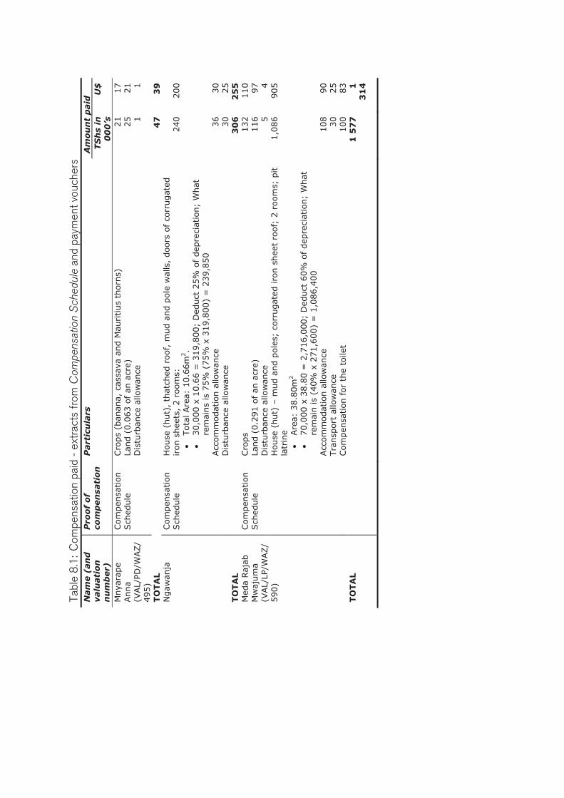
Tab
le 8
.1:
Co
mp
en
satio
n p
aid
- e
xtra
cts
fro
m C
ompe
nsat
ion
Sch
edul
e an
d p
aym
en
t vo
uch
ers
N
am
e (
an
d
valu
ati
on
n
um
ber)
Pro
of
of
com
pen
sati
on
P
art
icu
lars
A
mo
un
t p
aid
TS
hs
in
00
0’s
U
$
Mnya
rape
Anna
(VAL/
PD/W
AZ/
495)
Com
pen
sation
Sch
edule
Cro
ps
(ban
ana,
cas
sava
and M
auritius
thorn
s)
21
17
Land (
0.0
63 o
f an
acr
e)
25
21
Dis
turb
ance
allo
wan
ce
1
1
TO
TA
L
47
3
9
Ngaw
anja
Com
pen
sation
Sch
edule
H
ouse
(hut)
, th
atch
ed r
oof,
mud a
nd p
ole
wal
ls,
doors
of co
rrugat
ed
iron s
hee
ts,
2 r
oom
s:
�Tota
l Are
a: 1
0.6
6m
2.
�30,0
00 x
10.6
6 =
319,8
00;
Ded
uct
25%
of
dep
reci
atio
n;
What
re
mai
ns
is 7
5%
(75%
x 3
19,8
00)
= 2
39,8
50
240
200
Acc
om
modat
ion a
llow
ance
36
30
Dis
turb
ance
allo
wan
ce
30
25
TO
TA
L
30
6
25
5
Med
a Raj
ab
Mw
ajum
a (V
AL/
LP/W
AZ/
590)
Com
pen
sation
Sch
edule
Cro
ps
132
110
Land (
0.2
91 o
f an
acr
e)
116
97
Dis
turb
ance
allo
wan
ce
5
4
House
(hut)
– m
ud a
nd p
ole
s; c
orr
ugat
ed iro
n s
hee
t ro
of;
2 r
oom
s; p
it
latr
ine
�Are
a: 3
8.8
0m
2
�70,0
00 x
38.8
0 =
2,7
16,0
00;
Ded
uct
60%
of dep
reci
atio
n;
What
re
mai
n is
(40%
x 2
71,6
00)
= 1
,086,4
00
1,0
86
905
Acc
om
modat
ion a
llow
ance
108
90
Tra
nsp
ort
allo
wan
ce
30
25
Com
pen
sation
for
the
toile
t 100
83
TO
TA
L
1 5
77
1
3
14

Nam
e (
an
d
valu
ati
on
n
um
ber)
Pro
of
of
com
pen
sati
on
P
art
icu
lars
A
mo
un
t p
aid
TS
hs
in
00
0’s
U
$
Arn
old
Kim
ati
Com
pen
sation
Sch
edule
Cro
ps
212
177
Land (
0.0
67 o
f an
acr
e)
27
22
Dis
turb
ance
allo
wan
ce
1
1
SU
B T
OTA
L 1
2
40
2
00
H
ouse
(hut)
: Cem
ent
blo
cks;
corr
ugat
ed iro
n s
hee
t ro
of;
wooden
w
indow
s plu
s w
ire
mar
sh;
wooden
doors
; ce
men
t floor;
1 r
oom
; pit
latr
ine
with c
emen
t floor
but
wal
ls c
onst
ruct
ed o
f co
rrugat
ed iro
n
shee
ts
�Are
a: 1
1.5
6m
2
�110,0
00 x
11.5
6m
2 =
1,2
71,6
00;
Ded
uct
30%
of dep
reci
atio
n;
What
rem
ain is
(70%
x 1
,271,6
00)
= 8
90,1
20
890
742
Com
pen
sation
for
the
toile
t 150
125
SU
B T
OTA
L 2
1
04
0
86
7
Sourc
e:
Ext
ract
s fr
om
com
pen
sation s
ched
ule
s an
d p
aym
ent
vouch
ers
– H
ouse
hold
inte
rvie
ws,
Waz
o-M
ivum
oni, M
arch
-August
, 2011

107
8.3 Market value for land questioned
Determination of the market value for the land amidst absence of a land cadastre raises question marks. Although the government claims to use market value to compensate property owners in Wazo-Mivumoni, the approach through which the market value is determined raises several concerns that make it unattractive to sitting land occupiers. For example, an examination of the prices people paid to access land (for those who accessed through buying) around the time the project was conceived (1999 to 2000) indicate big variations of prices for the same size of land. Table 8.2: Size of land and buying price prior to 20,000 Plots Project S/Nr Interview
NrSize of land
(in acres) Year
bought Price paid
in TShs (ooo’s)
Price per acre TShs
(000’s) USD
1 2 0.7 2000 170 227 190 2 3 0.1 2000 60 811 676 3 4 0.25 2001 80 320 267 4 5 4.0 2001 950 238 198 5 21 1.0 2000 20 20 17 6 23 0.25 2002 150 600 500 7 24 0.25 1999 50 200 167 8 25 0.25 2002 180 720 600 9 28 2.0 2001 30 15 13
10 34 0.25 1999 300 1 200 1 000 11 42 0.5 2001 300 600 500 12 48 0.25 2000 250 1 000 833 13 49 1.0 2000 100 100 83 14 50 0.25 2002 50 200 167 15 60 0.5 1999 75 150 125 16 64 0.5 1999 400 800 667 17 75 0.1 2000 85 860 717
As seen in the table 8.2, one acre of land was bought at between TShs. 15,000/= (U$ 12.5) and TShs. 1,200,000/= (U$. 1,000) between 1999 and 2001. These are significant differences that rendered it difficult to arrive at an adjusted figure of TShs. 400,000/= (U$ 333) per acre that was adopted by the government as the market value after comparing prices from recent sales of land in the City. Theories have underscored weaknesses of the market approach in delivering land for public use. Some of the problems are associated with determination of compensation based on pre-development and not post-development status; the use of government-determined, moderated and
108
adjusted compensation values purported to represent market values. Other shortcomings underlined in the land delivery theory which undermines successful delivery of land for public use include lack of cadastre and up to date register of properties. With these shortcomings, determination of market values for land remains flawed. This seems to be the situation in the case of Wazo-Mivumoni, where market value for properties was attempted. 8.4 Conditions for acquiring a planned plot not clear
to residents
Household’s interviews in Wazo-Mivumoni revealed that though majority of the former land occupiers remained in the settlement; and got a plot within the area where their land was. Those whose land was converted into social/community services including open spaces, markets; roads and cemeteries were displaced. Moreover, some of these have neither been compensated nor given any alternative resettlement area to date i.e. nine years later. The current Mtaa Chairman for Kisanga (one of the two Mtaa areas that comprise the Wazo-Mivumoni project) noted that lack of explicit knowledge on the conditionalities for one to get a planned was one of the reasons that some residents were unable to get either a plot or tried without success. According to sections 9B (ii) and 12 of the Land Allocation Committee Regulation, plot can be allocated by the Land Allocation Committee, upon request by an applicant. The regulations further stipulate factors to be considered by the committee in order to approve or disapprove an application for land, (URT, 2001c). These include:
i) applicants ability to develop the land in accordance with development conditions,
ii) basis of first in first out, iii) principle of equity, reasonableness, fairness and gender balance,
and iv) the needs of disadvantaged groups, (URT, 2001c).
Interview with households revealed that many were not aware of this condition that required them to show interest by applying for a plot.

109
Explaining how this was operationalised and thereby restrained many households from accessing a plot, the Mtaa Chairman noted that once one declares his/her interest to get a plot; and had chosen a plot from the survey plan s/he would wish to be allocated, s/he was presented with a voucher that gave the household that aspired to be allocated a plot, a balance of 14 days (from the date the voucher was issued) to pay for the plot. Failure to effect payment within the 14 days time-span, the voucher expired and the plot was floated in the market for any other buyer who was ready to pay for it. Because many were not aware of this condition, found themselves in repeated saga of choosing a plot only to be told that it has already been given to somebody else.
"...At the beginning, many took the vouchers but did not pay within the 14 days time-span. The vouchers' (validity) expired and the plots were floated in the market for any buyer who was ready to pay for it’. This was the beginning of many of the conflicts we have to date...”38
The following story by Mr. Ngawanje (one the victims caught up in this situation) illustrates the matter:
“...We were compensated 980,000/= for crops; 239,850/= for house; 36,000/= for makazi (i.e. disturbance allowance) and 30,000/= for transport. Compensation for land was paid later (next phase of payment). We were told that a road will pass through our land and that we should vacate after receiving compensation. But when the survey plan was displayed at Kinondoni Municipal Council (in 2004), we realized that no road had passed through our land and that our house had been accommodated in the survey plan. The plot was given No. 47 in Block 6. In accordance with the conditions for one to get a plot, in this case, we were supposed to be allocated the same plot at subsidised price although the project officials wanted us to vacate after being paid compensation. Instead of vacating, we chose the same Plot No. 47 in Block 6 disregarding the explanation given earlier that a road will run through our land and that we should vacate. Thereafter, we proceeded to the Ministry of Lands, Housing and Human Settlements Development so as to pay for the plot; but we were told to wait for our compensation money and then vacate
38 Interview with Mr. Kimolo Kimolo; Mtaa Chairman for Kisanga at the Mtaa office on 17th April 2011.
110
the land. We inquired why we should vacate while our plot is intact; there is no road that had passed there and our house has fitted well into the plot and hence the survey plan. The project officials in the Ministry of Lands, Housing and Human Settlements insisted that once we are compensated, we should leave. They further emphasized that if we need a plot, we should choose another one, not Plot No. 47 in Block 6. For the fear of not getting a plot at all, we went back to Kinondoni Municipal Council where the survey plan was displayed and chose Plot No. 126 in Block 4. We went back to the Ministry of Lands, Housing and Human Settlements to pay for this plot a couple of days later; it was again cancelled on an argument that it had already been sold. By this time, the compensation for the land was ready. After being paid we chose plot No. 131 Block 4 and went back to the Ministry of Lands, Housing and Human Settlements to pay for it. This time we were told that we have already received the compensation money and we should pay the official price (full project cost) for the plot, not a subsidised price. Upon being told this we asked why we should pay full price while the project found us there. The project officials insisted that if we needed a plot, then we should pay the full project cost. Upon being told this we got angry and resorted to go back to our land where we had our house. On 3rd May 2007 the Ministry sold the plot to Mr and Mrs. Leons and Waridi Kamanija (not real names) who thereafter came over to Wazo and told us to vacate because they wanted to start construction work. We refused; maintaining that we will not vacate unless we are given an alternative plot. They responded that they are not concerned about that; instead we should consult the Ministry of Lands, Housing and Human Settlements. Then, we wrote to the Commissioner for Lands, narrating the entire history and episodes concerning our land. We requested the government to allocate that plot to us because we had all the rights as per the project conditions. The response to this letter came through on 18/06/2009; letter Ref. LD/233885/5, maintaining that we have been compensated in respect of the house and crops that were on the land. The letter further stated that ‘I did not show any intention/desire to be allocated the plot; henceforth it

111
was floated in the market until 03/05/2007 when Mr and Mrs. Leons and Waridi Kamanija (not real names) paid for it. We wrote again to the Ministry of Lands, Housing and Human Settlements on 09/07/2009 pledging to them to allocate us Plot No. 47 in Block 6 because we were living here and it was also one of the project policy that a person with a house will not be relocated but allocated the plot at subsidised cost i.e. paying for the survey cost. The Ministry of Lands, Housing and Human Settlements responded on 31/08/2009; letter Ref. LD/233885, asking us to refer to their letter of 18/06/2009. We were not satisfied with this; and on 15/04/2010 we wrote to the Permanent Secretary - Ministry of Lands, Housing and Human Settlements on our dissatisfaction with the response of the Ministry via their letter of 18/06/2009. Even with this letter, no response had come through up to the date of this interview (02/04/2011). Then, on 15th April 2010, we wrote again to the PS, Ministry of lands to explain our dissatisfaction with the responses we received from the Ministry of Lands that requires us to vacate We also complained about misconduct among project officials that not only dents the image of the Ministry, but also disregards the rights of the residents. This letter received no response. Although no response had come from the Ministry of Lands, Housing and Human Settlements; friction is still on-going on the said Plot No. 47 in Block 6. After Mr and Mrs. Leons and Waridi Kamanija (not real names) visited the plot in 2006 and asked me to vacate and demolish my house, Ms. Waridi (not real name) came back in 2010 when I was away in Lindi, my home region in southern part of the country (attending my wife who was sick) and demolished my house. When I came back and found that my house was demolished, I reported the matter to the Mivumoni Mtaa Chairman, Mr. Deo Kamugisha. The Mtaa government came over to inspect the site and issued a directive to Ms. Waridi (not real name) not to continue with any development activities on the disputed land until the matter is resolved. Thereafter, the Mtaa Chairman summoned both of us to

112
the Mtaa office to tender our evidence. Ms. Waridi (not real name) came with a title deed issued to her by the Ministry of Lands, Housing and Human Settlements Development showing that she is the legal owner of the plot; while I carried copies of the letters I was writing to and responses I was getting from the Ministry of Lands, Housing and Human Settlements. During the meeting the Mtaa Chairman advised us to consult the Project Manager for further advice. On 3rd May 2010, the three of us (myself, Ms. Waridi (not real name) and the Mtaa Chairman) went to meet the Project Manager. After hot discussion, the Project Manager reiterated his former stand that I did not show any interest to be allocated the plot in the first place. Then the Project Manager turned to the Mtaa Chairman and said “Chairman; I request you (all) to go back. Write a letter to allow Rose to continue with development activities on the plot”. As for me I was told to write my complaints and submit via the Mtaa Chairman, and then the Ministry of Lands, Housing and Human Settlements will handle the matter. On 10th May 2010 the Mtaa Chairman wrote a letter to the Project Manager stating that he cannot write a letter to allow Rose to develop the plot that initially had a house of Mr. Ngawanja. To substantiate his stance, the Mtaa Chairman noted that after all, Ms. Waridi (not real name) had demolished the house of Mr. Ngawanja without following legal procedures or even reporting the matter to the Mtaa Government. He maintained that every person has a right to life and develop his/her property. Since then, the Mtaa Chairman had not make any follow ups. These developments outstanding, Ms. Waridi (not real name) continued with construction of her house on the site. As of now she has completed construction and she has already moved into the house. Meanwhile, the letter from the Mtaa Chairman to the Project Manager has not been replied. I am now living in a rental room within Mivumoni where I am paying TShs. 5,000/= (4 U$) per month. My next plan when I get some money is to further consult the Permanent Secretary in the Ministry of Lands, Housing and Human Settlements..."

113
From this story it is clear that project conditions were not well understood by the residents. In this case for example, Mr. Ngawanja was fully compensated; thereby, required to pay official price should he requested for a plot contrary to the subsidized price he was praying for. This was one the project conditions. But what seems to be the case here is that Mr. Ngawanja was not fully aware of the project conditions, particularly on the validity of the voucher and the requirement to pay for the plot within specified number of days before the plot was floated in the market for another potential buyer. Even though the complainant did not show interest to be given a plot as provided for under Sections 9B (ii) and 12 of the Land (Allocation Committee) Regulation of 2001, but as long as the project conditions provided that a person affected that way would be entitled for one plot, Mr. Ngawanja was supposed to get a plot even at official price (because he was fully compensated). Therefore, this remained a rightful claim for Mr. Ngawanja as the person allocated the plot; Ms. Waridi (not real name) had not developed it. For humanitarian reasons, and in line with the provisions of first in first out and the principle of equity, reasonableness and fairness provided in sections 9B (ii) and 12 of the Land (Allocation Committee) Regulation of 2001, and considering the hardships/social stress and sufferings such a displacee would have to go through if displaced, a reasonable mind would give priority to the sitting land occupier; and an alternative plot be searched or granted for Ms. Waridi (not real name). This is particularly so because as repeatedly seen, many people affected by the project were not aware of their rights, obligations and the project protocols. The case above signifies gross underestimation and disregard of the livelihoods options of the poor once displaced and their assets destroyed. One would expect that for the image of a public institution and for the sake of good land administration practices, decisions that affect the poor would be carefully examined and options explored in order to avoid accentuation of inequality and poverty. This does not seem to have been critically weighed out in this case.

114
8.5 Private interests at the expense of the residents
Violation of legal provisions and lack of understanding of one's rights and obligations as depicted in the case of Mr. Ngawanja versus Mr and Mrs. Leons and Waridi Kamanija (not real names) shows unfair treatment of sitting land occupiers and violation of human rights. In this situation, one is made to wonder why was this done? And for whose interests? According to the project policy, a person affected that way was supposed to be fully compensated and would be free to buy a plot anywhere within the project area at full project cost. In this case, the complainant was cheated that a road will run through his land, and that he would be displaced. Then the project paid him full compensation including disturbance and transport allowance primarily because the interest was to evict him, despite existence of a provision that entitles him that plot. However, because the aggrieved person was somehow knowledgeable; was able to read the survey plan and realize that his plot and house were intact; and no road had run through as was earlier argued. At this juncture, the question is why did the project trick him? Why did the project team and the Commissioner for Lands (representing the President on land matters) refuse to listen to the complaints of this household despite repeated calls at the Ministry? On the other side, when negotiations were on-going since 2004, the plot had not been sold yet until 2007 when it was sold to Mr and Mrs. Leons and Waridi Kamanija (not real names). In this respect, one can question the arguments that a person who wanted to be allocated a plot was required to show an intention to be allocated a plot by filling special forms. Whilst Ngawanja was making follow up since 2004; Ms. Waridi (not real name) came 2 years later and was allocated the same plot ignoring Ngawanja’s situation and appeals. This shows that the desire by the government to pay compensation and ensure that the affected households are restored to the same position as they were before their land was expropriated cannot be met or was not even considered as one of the most critical tenets of payment of compensation in areas where land is acquired for public use.

115
8.6 The double faces of local leaders and residents
The following case by Ms. Delfina Elikasa (not real name) whose land was expropriated and designated for cemeteries illustrates a situation where some of the resident cheated in order to get a plot at subsidised price. As the residents cheated on one hand, on the other, respective local leader declined from telling the truth though they knew that the residents were cheating. This lady was compensated for her house TShs. 1.1.M (equivalent to U$ 917) and crops TShs. 230,000/= (equivalent to U$ 192). In an interview with the author, the lady said that she was neither given disturbance allowance; transport allowance nor alternative plot; and that she was still living on the same area which is now zoned for cemeteries.
“...Although my land was taken to accommodate cemeteries, I have not been given an alternative plot. I followed up the matter with the late Mr. Mugemuzi (who was the Project Manager) but with no solution. I kept following up the project manager to allocate me a plot within Mivumoni area where I have been living for years. One day when I went to see him he told me that there were not any more plots left. He thus asked me to be patient while he was looking for another plot which could be affordable to me. But before this was realized; Mr. Mugemuzi passed away in a road accident. Thereafter officials from Kinondoni Municipal Council came to inspect the community areas and found me still living there. They called me to their offices; where among others they asked who gave me the permission to build a house and live in the area demarcated for cemeteries? I could not talk much apart from showing them Land Form No. 69. When they read it they exclaimed “so the project found you there?” I said yes; and told them the whole story. Then they asked me if I was compensated? I said yes. They further asked if I was given an alternative plot; I said no. I told them that I had followed the matter since 2002 but have not been given any plot to date. They asked if I could build a house if I am allocated a plot today. I told them yes. Upon this, the KMC officials promised that my problem will be dealt with. As I was waiting for the response from the Kinondoni Municipal Council; a big meeting was called by Ntakamulenga, the new
116
Project Manager within the settlement on 23rd December 2010. When we were given opportunity to ask questions, I stood up, but before I spoke, Mr. Timoth Titus (not real name), one of the Mtaa Officials, interrupted by shouting “mama makaburini anaendelea kuwepo makaburini"; meaning that the cemetery lady will continue to live in the cemetery. The Mtaa Official continued: “her problems have already been solved because the Kinondoni Municipal Council has promised to give her a plot. Therefore, I request that this matter of the cemetery lady be left with me”. This marked the end of my efforts to further follow up the matter because whenever I check with the Mtaa Official he is simply telling me to vacate the cemetery area...”39
From this story of cemetery lady, it was ironic that the project people were that insensitive even when the matter was reported before a public meeting. Thus the need to cross-check this information to establish the fact became apparent. Therefore I interviewed one of the Kisanga Mtaa Officials for clarification. He noted that the lady had distorted some of the facts she earlier presented to me. The Mtaa Chairman noted that apart from being fully compensated, the lady was also given a voucher that she could have used to pay for Plot No.13 Block 4 in Mivumoni. However, the lady sold the voucher to another person while herself continued to live in the former are where she was required to vacate. Further, the Mtaa Official noted that the lady sold the voucher to an alien person who later paid for the plot. Further interview with a relative to Ms. Delfina Elikasa (not real name) revealed that her sister (Ms. Delfina) was actually given a voucher for the plot but didn’t know why she did not pay for the plot. Although this is not a solid evidence, but it confirms the words of the Mtaa Official that the lady was issued with a voucher to pay for the plot but she did not pay for it. This means that the lady cheated when she said that she had not been allocated an alternative plot. About 8 years later (i.e. 2010), when the Kinondoni Municipal officials were inspecting the areas earmarked for community services including cemeteries, they really found her living there i.e. the area zoned as cemetery. As noted by the Mtaa Official, the lady lied to the Kinondoni 39 Discussion with Ms. Delfina Elikasa (not real name) at her residence in Mivumoni on 23rd Match 2011.

117
Municipal officials that she has not been given an alternative plot. She also repeated the same in a public meeting on held on 23rd December 2010 in the settlement and attended by a total of 21 people including top officials from the 20,000 Plots Project and the Mtaa Official for Kisanga. In this meeting, the lady was quoted as saying:
"... I have not been given an alternative plot; I am requesting to be given one so that I can vacate the area designated for cemetery because people have started to bury their dead relative there..."
Ironically, although the Mtaa Official knew that the lady was cheating (in the meeting), he deliberately kept silent, letting the lady try her second chance. The Project officials should have probably known this as they had all the documentation; but they too did not take action even after the meeting. Asking the Mtaa Official why he allowed false information to be presented in the (official) meeting without taking actions on the spot or even later, the Mtaa Official insisted that he did not want to abort the lady’s plot. He also refuted the allegation against him (by the lady) that he is frustrating her efforts to be given a plot by the Kinondoni Municipality. He argued that it is not the responsibility of Mtaa Officials to follow up the plot promised to the lady by Kinondoni Municipality, instead the lady should follow it up.
"...Sikutaka kuonyesha kwamba alikuwa ameshapata kiwanja awali. Si unajua hiyo ingekuwa ni fitina? Hiki kiwanja alichoahidiwa na Manispaa ya Kinondoni yeye ndio alitakiwa afuatilie. Manispaa wamemwambia kwamba watampa kiwanja; sasa suala la kwenda kufuatilia Manispaa ni la kiongozi wa Serikali ya Mtaa?...".
Meaning that:
“…I did not want to show that she had earlier been given an alternative plot. This would have been hypocrisy. But it was her responsibility to follow up the plot she was promised by KMC. Is it the responsibility of Mtaa Officials to follow up the plot...” 40
This situation facing the affected land owner, Mtaa Official and even the Project officials reveal the double faces that both officials and 40 Discussion with Mr. Timoth Titus (not real name), one of the Mtaa Officials on 30th August 2011 in Kisanga Mtaa area.

118
residents were wearing. In this case, the affected resident intended to cheat the government and is likely to succeed. On the other hand, the local leaders charged with the responsibility of authenticating the identity of households that qualified for compensation, betrayed their very role amidst being fully aware of what they were doing. This underscores malpractices in the process of valuation and payment of compensation. On the other hand, it also underlines gross violation of ethics among those charged with leadership responsibilities. As such, it is no wonder that implementation of the 20,000 Plots Project stirred conflicts and attracted complaints from the affected residents. Although the project was operating on cost-recovery approach, this kind of attitude would definitely escalate project implementation cost that may ultimately hinder effective cost recovery. 8.7 Delayed payment of compensation
The first phase of the valuation exercise which was for crops and land was done between September and December 2002. The second phase, which was for houses, was done in 2004. The verification of properties and subsequent valuation of houses was undertaken from 17/06/2004 to 19/07/2004 (Letter from Ministry of Lands Housing and Human Settlements Development; Ref. No. MLHSD/TF/M/1/96 of 18/08/2005). Examination of the Land Forms No. 69 (that were counter signed when the valuation was done and when compensation was paid), indicate that compensation payment started to be issued in 2005. Household interviews in the settlement also confirmed the same, whereby 44 people out of 77 (59.5 percent) indicated to have been compensated towards the second half of 2005. This is almost three years since when valuation was undertaken. Although both the Land Act No. 4 of 1999 and Land Regulations of 2001 requires that payment of interest at commercial bank rates be paid for delays beyond 6 months since when valuation was undertaken; this legal requirement was not complied with. One wonders why this was not done while this project has been defended as a special one and that funds were available for the respective budget activities prior to commencement of the project. Since funds for this component were available prior to commencement of the

119
project, delayed payment of compensation not only points to administrative snags, but also lack of appreciation of the role of assets held by the poor households to their livelihoods. 8.8 Summary and reflections
There is no question that acquisition of land in Wazo-Mivumoni was for good interest i.e. of public interest geared to facilitate planned expansion of the city and ensure optimal use of land resource. This is indisputably an important and genuine step taken by the government. However, the relationship between decision makers and the affected residents versus adherence to laid down procedures and legal provisions leaves a lot to be desired. This is especially the case when one considers the fact that the acquisition of land for public use; be it under special (like the 20,000 Plots Project) or non-special project, should be done in accordance to the laws of the country. As a result, violation of the same ads up to under-estimation of the roles the assets of the poor people play in their livelihoods. More so, it defies the legal desire to restore affected people into the same condition as they were before acquisition of their properties. In countries like Tanzania where the bulk of urban population is poor and unable to meet the basics, displacing such persons without regard to adequate/fair compensation or resettlement area where they can continue with life albeit at much poorer situation, it is a gross deficit in policy and legislative contexts.
The empirical results discussed in the previous chapters revealed inconsistencies from project conception throughout to the implementation process. Despite weaknesses in the laws providing for compulsory land acquisition, the implementation process was also found to be associated with irregularities. Thus, within this context, the land, prime asset of the Wazo-Mivumoni households, was acquired. The next chapter discusses how the livelihoods of the households were disrupted and what strategies they adopted to sustain their lives.


121
9. IMPACTS AND COPING STRATEGIES
ADOPTED BY HOUSEHOLDS
In this chapter, the impacts that the Wazo-Mivumoni households suffered due to acquisition of their assets are discussed. Likewise, the various strategies adopted to cushion the impacts are also discussed.
9.1 Project implementation vis-à-vis livelihoods of
households
The implementation of the 20,000 Plots Project in Wazo-Mivumoni brought about land use changes from a combination of farming and non-farming activities to purely residential and community service related activities. Consequently, the changes also affected the livelihoods of the people. As argued by the Sustainable Livelihoods Framework, the various assets (land, animals, social networks) that the Wazo-Mivumoni settlers mobilised to sustain their lives were acted upon by the transformation processes namely the laws, policies and regulations implemented by various levels of the governments i.e. Central Government Ministries and Local Government Authority and the private sector such as firms and individuals involved in the cadastral survey i.e. the transformation structures. From the discussion on section 3.6, it was argued that if governments do not act in an accountable and responsive manner i.e. consider the concerns of the resident, project implementation may result to negative impacts. The laws and regulations which comprise the transformation processes were found to be inadequate to respond to current social and economic situations such as the need to restore the affected households to the same condition they were before implementation of the project. Likewise, implementation of the same was flawed with lack of accountability and unprofessional ethics among those charged with responsibilities. This also included violation of provisions that requires participation of affected residents in the planning process. Drawing from the Sustainable Livelihood Framework, these weaknesses caused the implementation of the 20,000 Plots Project in Wazo-Mivumoni to result to negative outcomes. Majority of the sitting land occupiers lost

122
their sources of livelihood (land) and housing/shelter. The discussion below further illustrates this. One of the concerns of SLF that led to its formulation in the 1990’s was the need to understand the livelihoods of the people prior to intervention so as to achieve sustainable results. The study in Wazo-Mivumoni revealed that the livelihoods of the households mostly depended upon farming, animal keeping, housing and social networks. However, there was little or no attempt to understand the role these assets played into the livelihoods of the households. Even the valuation process was flawed with a number of weaknesses such as weak legal premises to restore the affected households into same condition as they were prior to project implementation. The failure to evoke and use market values as provided by the Land Act (1999) and also argued by the Land Delivery theory underscores lack of appreciation of the role that these assets played into households’ livelihoods. In turn this led to poor remuneration of the assets in respect of inadequate compensation that was paid. As a result of this, the implementation of the project grossly disrupted the livelihoods of the people. Farming and animal keeping which were carried out concurrently were almost fully displaced. About 91 percent of the interviewed residents who initially practiced farming and animal keeping are no longer able to do it. Livelihoods activities outside Wazo-Mivumoni which comprised 3 percent of the interviewees also got displaced. These people cannot afford to go far from their houses in search for jobs or casual labour for the fear that the government people can come and take away their land while they are away. So, they have to be somewhere close to home so that they can intervene if such a thing happens. Social networks were also broken down. Although only a few people commented on this because of insufficient emphasis that was placed on this question during interviews, the fact remains that at present there are no evidence of the social networks that were reported to be very vibrant prior to project implementation. Although implementation of the project could be seen as an avenue to build new social networks between the aliens and the local community, this has remained impossible as the two classes belongs to two different worlds. This fact is also underscored by Magembe-Mushi (2011:35)

123
when arguing for non-existence of a leveled platform for the sitting land occupiers to co-exist with aliens (new comers) in regualrised projects. She noted that:
“…it will take a while before the so called new comers or outsiders… fit within the new society and be considered and trusted as part of the community…”
It can also be argued that because the land acquisition process was not transparent, and the project seen as an enemy to the residents, it followed that the aliens were also viewed as a product of the same process that took away the properties of the local people. Hence, the aliens were seen by the local population as grabbers of their land. In this respect, social networks between the two groups remain elusive. Although majority (95 percent) of the interviewed residents were negatively affected, there were a few (5 percent) who benefited positively from implementation of the project. Some of the benefits seen to be associated with implementation of the project include having a surveyed and planned settlement. Although social services are still underprovided, accessibility within the settlement is highly enhanced. A few individuals among those whose plots are fronting local access roads are now engaged in small-scale business activities. In addition, a few of the allotees of plots under the project managed to get bigger plot sizes than what they owned prior to implementation of the project, Table 9.1 further illustrate the foregoing. Table 9.1: Key livelihoods affected by implementation of the 20,000
Plots Project S/Nr Affected livelihoods Nr Percent
1 Farming; animal keeping; retail business 70 91 2 Cannot go for casual labouring outside
Wazo-Mivumoni; fear of losing land 2 3
3 Project had no negative impacts 4 5 4 Social capital/networks is destroyed 1 1
77 100
9.2 Impacts arising from disruption of livelihoods
Change of land use also meant that the lives of those who were engaged in farming activities have been affected. Household interviews

124
conducted in the case study area indicate that those affected negatively by the project have suffered both socially and economically. These adverse impacts are inter-twined and they reinforce one another. 9.2.1 Social impacts The social impacts due to loss of livelihoods include loss of social networks among community members, as well as loss of housing. Although one would expect that social networks would have been created, but as shown above, it was not the case. Drawing from the days prior to project implementation, the social networks provided safety-nets among community members. Resources including labour, cash and social support were not only easily solicited but also provided an alternative to formal approaches to earn incomes in case of immediate help. 9.2.2 Economic impacts Loss of other assets such as land and animals which were sources of income and employment generation to the residents prior to project implementation; also meant that affected households were put in more difficult position economically as they could not meet some of the basic needs including food production necessary to sustain their families as well as cost for social services including fees for their children.
“...Since the project was implemented, farming is no longer possible. Before the project I was getting enough supplies of vegetables and cereals from my farm. This is no longer possible and lifestyle has changed; now I have to buy everything. This has made life more costly. Before the project, I could survive on TShs. 2,000/= (1.7 U$) per week because there were many substitutes from the farms, but now I cannot make it even at TShs. 10,000/= (8.3 U$) per day...”41 “...Before the coming of the project I was having 24 goats; 1 cow; 85 chicken of local breed; and 400 chicken - broiler. These provided a good source of income. By then, a goat was selling at TShs. 30,000/= (25 U$); a chicken at between TShs. 7,000/= and 9,000/=
41 Discussion with Mr. Sago Widlon (34 years) at his residence in Kisanga Mtaa area on 19th March 2011.

125
(5.8 – 7.5 U$). My average income from sale of chicken alone was around TShs. 2.8 millions (2,333 U$) after every five weeks. I used to sell 400 chickens after every five weeks. But this is no longer the case now as I have become a friend of the shop, meaning that I am now buying my basic necessities almost on daily basis..."42 “...Currently a big chunk of my budget is used to purchase food contrary to the time before the project. Before the project, I used to farm and my income was mostly used to strengthen my other businesses because food was available. Immediately after the project, I became unproductive, for two years; as I was making follow ups to get a plot (which I finally got after a lot of bureaucracy). During that time, I could not go to work; I was a TV technician in one company in Zanzibar. Because of no-show ups at work as I was busy following up to get a plot, I was fired...”43
These quotes suggests that sale from animals (duck and pigeons) was worthy over TShs. 2.5 millions (2,083 U$). This is not a small income from a single project for a poor household. It is also crucial to underscore the important role of the land to the settlers as a source of income and employment generation, not only for the core family, but as may be expected, for many other persons employed to take care of animal husbandry activities. This again underlines effects that arise from underestimation of the role of the assets held by the poor play in their lives. It also underscores the magnitude of effects to be suffered when a displaced person is not provided with an alternative residential and farming land as a precondition for restoring him/her to the same position. Without this, justice can hardly be said to have been done. On the other hand, lack of transparency and accountability in matters associated with land expropriation as the case study shows, could also impose other un-expected costs such as loss of employment because of failure to turn or perform as expected due to endless follow ups. In addition, because of lack of transparency and unpredictability of what will be the next move by the government officials, people are living on
42 Discussion with Mr. Barnabas Robbi (72 years) at his residence in Kisanga Mtaa on 16th March 2011. 43 Discussion with Mr. Arnold Betuel Kimati (47 years) at his residence in Kisanga Mtaa on 22nd March 2011.

126
worries which translate to hesitations to effectively invest on the land. The following quote by one resident who paid for her plot in instalments illustrates the matter:
“...Life was much better before implementation of the project. Then I was living comfortably without any worries. Right now, I am worried that a rich person can buy my plot and evict me. I will not have peace of mind till I have finished outstanding payments for this plot; I requested to pay for this plot in instalments. The total cost is TShs. 870,000/= (725 U$); I have already paid TShs. 200,000/= (167 U$) only. I hope, after clearing the debt, I will not only lead a peaceful life, but also gain weight. Right now I am so worried; whenever I see an affluent person driving around or park his car near my plot for whatever reasons, my heart beats increases for fear that probably he has bought my plot. It is not until he is gone that I settle down again..."44
According to discussion with the Mtaa Chairman (30/08/2011), there are no doubts that there are so many similar cases, where poor people are worried of losing their land and are living in untold worries. 9.3 Strategies adopted to overcome adverse impacts
Meikle (2001:12) noted that formation of livelihood strategies is dependent upon the available assets, the prevailing context and objectives of the people involved. Therefore, strategies adopted by residents in Wazo-Mivumoni are considered in respect of the assets they could mobilise after project implementation, likewise the context that ensued project implementation. As seen before, land held by residents was reduced, likewise animal keeping was no longer possible and social networks were displaced. This constituted the context after project implementation. The strategies adopted were mostly anchored on this premise and were geared towards overcoming the adverse social and economic impacts discussed above. According to the sustainable livelihood framework, the ability of households to survive and recover from shocks and stresses and transform assets at their disposal into incomes, food or other basic requirements is referred to as resilience. 44 Discussion with Ms. Hasha Emedi Mbindeni; 38 yrs at her residence in Kisanga Mtaa area on 26th March 2011.

127
Further, the Sustainable Livelihood Framework define livelihoods as sustainable when it can cope and recover from shocks and stresses and maintain its capabilities and assets to support the present generation without endangering the next generation both in the short and long run. In view of this, an attempt is made here to identify and discuss the strategies that were adopted in Wazo-Mivumoni and also assess their roles in making livelihoods sustainable. Household interviews in Wazo-Mivumoni show that four main strategies have been adopted to facilitate recovery from socio-economic impacts. These have focussed on both tangible and intangible assets at the disposal of the people (Table 9.2). The strategies include extensification i.e. establishment of new income generation and employment activities (47.0 percent); intensification through increased innovation and hardworking on old activities (33.0 percent); reliance on family supports (19.0 percent); and family splitting by dispatching family members back to the village (1.0 percent). Table 9.2: Strategies adopted to overcome adverse impacts S/Nr Adopted strategy Nr Percent
1 Extensification (new income generation and employment activities)
36 47
2 Intensification (increased innovation and hardworking on old activities)
25 33
3 Relying on family support (lost hope) 15 19 4 Family splitting (dispatching some
members of the family back to the village)
1 1
77 100
9.3.1 Extensification (new income and employment
generation activities) Extensification meant tapping of new assets and approaches to sustain livelihoods. Before implementation of the project, households in Wazo-Mivumoni were involved in land-based activities especially animal husbandry, keeping chicken, goats, ducks, cow and farming. However, after implementation of the 20,000 Plots Project, these activities were no longer possible, at least in the fashion and extent they used to be carried out. About 47 percent of the interviewed residents resorted to new livelihood activities that include keeping small number of exotic chicken using in-door techniques, small business/retail shops; bars,

128
building material outlets, soft drinks as well as selling of local brew and running a nursery school. Most of the stalls and retail shops are located in front of the plots; some are part of the main house while others are detached from it (Plate 9.1).
Plate: 9.1: New livelihood (economic) activities in Wazo-
Mivumoni On the other hand; being a newly planed area; there are lots of construction activities that are on-going. These have also created opportunities for casual labouring in construction sites including block making and carpentry activities. Those with houses along the access roads have also been able to rent out part of the house so as to earn an income. One such incidence is the case where two rooms have been rented out and are used as a nursery school.
“...I have rented out two rooms in my house which are used as a nursery school. The renter was interested because the house is located close to the access road. He is running a nursery school there...”45
45 Discussion with Mr. Tegemea Joseph Magonda (37 years); at his residence in Mivumoni on 24th March 2011.

129
Plate: 9.2: A nursery school in Wazo-Mivumoni
This however should not be misconstrued as to contradict the information given earlier that majority (about 95 percent) of the Wazo-Mivumoni residents were negatively affected. The point being made here is that; out of the 95 percent negatively affected, about half of them had at least resorted to new livelihood activities in order to sustain their lives. Even with this, it is important to note that it was done out of necessity rather than a choice. Furthermore, the level of satisfaction enjoyed prior to project implementation has not been achieved yet because not only that the context has changed, but also the stock of assets at their disposal has grossly been reduced. Establishment of retail business was mainly to respond to the needs of the local community, who unlike in the past when they had most of the food from their farming, now they have to buy on daily basis. About three people among those interviewed (and would likely be more if the whole of the affected people 1,193 are considered) had bought large farms in other parts of the city after they received their compensation money. These include those who bought farms in places like Kimanzichana (in Mkuranga District, Coast Region) as well as in the neighbouring areas like Miono in Bagamoyo and Ruvu where they undertake farming; producing food for their families as well as surplus

130
to supply to the urban areas. Other new activities that the affected population engages into include land-broking; and transport business especially by tricycles (popularly known as “bajaji” in Swahili) and motorcycles. An incident was also noted where an old man had bought a house in the nearby Tegeta settlement and uses it for renting out in order to raise incomes to support his family. The quote below further illustrates this:
“...I am still farming in this plot although I am required to vacate; it has been zoned for community facilities. However, out of the compensation money I received, I bought a six-room house in Tegeta. I have rented out two rooms, while the other four are used by my children. Of the 2 rooms one has been rented out as a shop at TShs. 30,000/= (U$ 25.0) per month, while the other one, is rented out for residential use at TShs. 25,000/= (21.0) per month...”46
Reflecting on this, it is obvious that although people are striving to come out of the negative impacts created by implementation of the project by trying to seize emerging opportunities, the fact remain that their livelihoods are still worse off compared to situation before implementation of the project. As noted by Meikle (2001:12), livelihood strategies may be deleterious to the environment as well as unsustainable in the longer run thus defy the notion of sustainability. Discussions on the valuation chapter revealed that in Wazo-Mivumoni, the people whose farms extended to the steep slope areas are still undertaking farming activities in those areas although they were compensated and required to vacate. Although these people are conscious that they are contravening the law, they have limited choices. This further justifies the fact that despite the strategies been adopted, livelihoods have not yet stabilised as they were before implementation of the project. 9.3.2 Intensification and increased innovation of old activities This strategy mostly involved strengthening activities that were initially undertaken prior to project implementation. These include casual labouring, stone quarrying; making bricks, selling of building materials such as cement, iron bars etc. Although these activities were not 46 Discussion with Mr. Issa Omari Seif (over 60yrs); at his residence in Mivumoni Mtaa on 30th March 2011.

131
completely new among those undertaking then, the important aspect was the extent and intensity of innovation and efforts that were put into these activities after the project. The quote below illustrates this:
“...I had to think of alternative ways to raise income. I bought one motorcycle; and one tricycle to ferry people and goods within the settlement. I have also rented out two rooms from my house at TShs. 15,000/= (U$ 12.5) per room per month...”47
Interviews conducted in Wazo-Mivumoni revealed that there is increased intensity of resource utilisation among the community members. On land for example, most were allocated one or two plots measuring around 600 square metres. Although this could be more or less equal the amount of land they held before, the development conditions attached to the land; for example only residential use is allowed, is a hindrance to many, URT (1956). In this respect, one cannot have the luxury of doing farming or animal keeping as it used to be before implementation of the project. Thus, the main option is to intensively use the available resources to sustain life. 9.3.3 Reliance on social and family support Most of the old people who are physically weak and do not have physical assets or energy to engage effectively in productive activities, do rely on support from their children and other family members. Included in this group also are the younger generations who are devoid of physical assets like land and animals in exception of their human capital. This is however unsustainable as the quote below illustrates:
“...I was begging for support from my relatives, but after some time they got tired to continue to support me. They told me to go back to my children. I had no choice other than banking on my children. If they do not get anything, we have to endure and try again another day...”48
47 Discussion with Mr. Sago Wildon (34 years) at his residence in Kisanga Mtaa on 19th March 2011. 48 Discussion with Ms. Khadija Maulid Najongo (widow, 52 years); at her residence in Kisanga Mtaa on 18th March 2011

132
This strategy denotes a state of desperation and a ticking time-bomb in a country where the social welfare system is weak or inexistent. The fact that this is more of a moral obligation, there is no reliability that the family members will extend support to the aggrieved persons. Approached from the sustainability point of view, this strategy remains only a palliative measure because the real problem of weakened livelihoods is still in place and likely to consolidate. 9.3.4 Family splitting (reducing size of the family) Due to hardships that ensued implementation of the project, some household heads found it difficult to support their families especially in the absence of reliable incomes. In consequence of this situation, one household head had to send some of the family members (wife and children) back to his home village to stay with the grandparents. The quote below illustrates the action taken by that household:
“...I am a freelance technician with no permanent working office. I was moving around to search for jobs. Because I was known for my skills and reputation, I hardly missed jobs. When my assets were affected by the project (one room house; crops; animals and land); it became difficult to sustain my family in town. Thus, I had to dispatch them back to my father’s place in Kilimanjaro Region. As this helped me to reduce the burden of taking care of the family, it also allowed me time to concentrate more on re-organising sources of livelihoods. For instance, I have started to rear chicken; I am also keeping ducks and pigeons. I am also thinking of other business activities..."49
This strategy was not found to be common, likewise it cannot be expressly substantiated if it brings any relief to the particular household and whether it is accepted in modern society or not. However, a glaring fact is that cost for running life will undoubtedly be higher because of transport cost and money remittances required to support the family back in the village. This apart, it also disturb the schooling cycle for the children because they had to be taken out of school in Wazo-Mivumoni and had to start afresh in the village. This also requires money to process for the transfer. 49 Discussion with Mr. Anorld Betuel Kimati (47 years) at his residence in Kisanga Mtaa on 22nd March 2011.

133
9.5 Sustainability of the strategies adopted to
overcome impacts
Overall, livelihoods have been destroyed and shocks created on livelihoods of the households. One can argue that, establishment of new income generating activities and intensification cannot be sustainable in the short run but rather in the long run. Likewise, both reliance on social and family support and family splitting are neither sustainable in the short nor in the long run. Establishment of new income generating activities and innovation are not promising to be sustainable in the short run because the opportunities for these activities to establish and run profitably are limited. They depend to a greater extent, on the macro-factors of the entire city of Dar es Salaam. The macro-factors include the necessary services such as power supply, water supply and reliable transport, of which Wazo-Mivumoni has to be well networked. For the economy to pick up, investment is very necessary. The productive sector within Wazo-Mivumoni, which is mostly agriculture, is still low to tap and anchor with the rest of the city. The SLF argues that a sustainable livelihood is the one that can cope with and recover from stresses and shocks and maintain its long productivity. In the absence of macro factors that can favor investment, this wish remains elusive. Therefore, unless the pre-conditions above are effectively met, sustainability of the economic-related strategies will remain unstable. Reliance on family and social support including reduction of family sizes is only a temporary solution in a country like Tanzania where the social welfare system is still weak and majority of the people are living in poverty. Although an alternative argument can be made here that the informal sector can boost up the needed support, this is only marginal because even the informal sector does not exist and operate as an isolated entity, but rather depend on the rest of the city economic fabric. Of importance here is how the informal sector can link up and tap the benefits of regionalization in the local context. In the meantime, this is still low because there is no vibrant productive sector in Wazo-Mivumoni. Most of the production from Wazo-Mivumoni is for daily consumption. In essence, these particular strategies are rather giving different faces to the problems associated with land acquisition because they remain real problems and even getting worse. Therefore, to some extent there are
134
improvement through adoption of the strategies, and possibly more in the long run (likely to be restored in the long run); but the bulk of livelihoods are currently disrupted, necessitating the affected sitting land occupiers to make it through difficulty ways. Among others, the land delivery theory advocates that effective participation and consultation of residents as well as evoking a transparent approach is vital for successful land acquisition projects. Although this is still an area to be explored in detail, an argument is raised here that had the residents been involved from the beginning, could possibly provided a platform for them to discuss the likely impacts well ahead of the implementation process. This could also have prepared them psychologically such that they could possibly team up with the government to search for alternatives to minimize the impacts. This may not necessarily involve cash but rather material and labor contributions. Having discussed the impacts and coping strategies that ensued implementation process for the 20,000 Plots Project in Wazo-Mivumoni, it is now time to reflect upon the land acquisition process vis-à-vis the livelihoods of the households in view of the theoretical and conceptual thinking. The discussion and reflections constitute food for thought regarding urban expansion processes, actions of policy makers and practitioners and the livelihoods of the affected households. These are presented in the next chapter.

135
10. ACCOMODATING LIVELIHOOD
CONCERNS IN PLANNED URBAN
EXPANSION PROCESSES
This chapter discuss empirical findings in relation to conceptual and theoretical concerns that are necessary to accommodate livelihoods concerns in compulsory land acquisitions. It also draws conclusions on the research questions raised at the beginning and likewise identify areas for further research.
10.1 DISCUSSION
The main trigger for urbanisation in developing countries is natural growth Tannerfeldt and Ljung (2006). About 60 percent of urban population in developing countries is an outcome of natural growth, 30 percent is a result of migration and 10 percent is contributed by expansion of urban boundaries. These forces constitute growth of urban areas demanding for more land to accommodate the expansion process. Thus, acquiring land from the peri urban areas in order to direct and guide urban expansion processes has often been the de-facto approach to accommodate the expansion process. As long as urbanization process is indeed an inevitable phenomenon of cities, land acquisition is not only unthought-of, but it is also here to stay. As noted by Narain (2009) and Xu et al (2010), peri-urban settlements are often the destination for compulsory land acquisition in order to accommodate urban expansion processes. Similar trends have been noted in India, China, Tanzania and Nigeria where states acquires land from the peri urban areas to accommodate either implementation of development project or land use plans. However, many a cases, as land is compulsorily acquired, households are left with smaller portions of land or none at all. In many of the developed countries urbanization moves parallel with economic development, but in most of the developing countries the opposite is true. The later is also the case in Dar es Salaam, Tanzania. Experiences from several peri urban areas where land has been
136
compulsorily acquired in order to accommodate urban expansion processes have been associated with force. As also demonstrated in the case of Wazo-Mivumoni, and supported by other studies Kombe, (2010), Ndjovu, (2003), Xu et al, (2010), Narain (2009) and Kusiluka (2010); compulsory land acquisitions have often resulted to not only changing land uses from agriculture to residential and residential commercial, but also disrupt the livelihoods of people and disrupt social networks and even alter the natural resource base. This constitutes a gross underestimation and appreciation of the role of assets of the poor households in sustaining their livelihoods. As argued by the Sustainable Livelihood Framework, successful outcomes of intervention into the livelihoods of the households require an understanding and appreciation of the assets they hold prior to intervention. As argued by Narain (2009), this can be achieved through the creation of some kind of stakeholder platforms that bring peri urban households face to face with planning authorities and that allow for some form of dialogue on the land acquisition process. This would build some elements of preparedness among peri-urban households, and will also help to make policies for land acquisition less top-down and more transparent. As a result, this platform can provide an opportunity for the peri-urban households and the government authorities to interact, thereby making the process of urban development more transparent whereby issues needing collaborative effort can be jointly addressed. The study in Wazo-Mivumoni clearly showed that land and other household assets such as animals, housing, crops and social networks play an important role in sustaining peri urban livelihoods. Land for example, constitute a cornerstone for economic development not only for the Wazo-Mivumoni households, but for most peri urban households in developing countries. Many activities including farming, animal keeping and businesses requires land for their establishment and operation. Having land also denotes the capacity of households to produce, and thus enjoy decent living standards and reduced vulnerability. Therefore, as land related interventions are considered, resident’s participation is a crucial part not only for the implementation process, but also from the policy formulation process.

137
Meaningful involvement means not only being physically present, but also able to influence decision and the implementation process. In order for this to happen, capacity building in terms of knowledge creation is vital. In cases like Wazo-Mivumoni, which involved acquisition of assets of respective households, the education component could entail educating households on impacts likely to arise during and after project implementation and how to cope with the situation. As revealed in this study, this was not done on the fear that residents could have derailed smooth start of the project. Although the project did not start as smooth as was envisaged, but also contentions arouse. This apart, residents had no knowledge on how to handle post-acquisition challenges. The shock they sustained after losing their assets militated against innovative thinking that would have paved new avenues to cushion the stress and sustain livelihoods. The influence of natural growth and migration as drivers of urbanization cannot be underestimated while discussing land acquisition and livelihoods in Wazo-Mivumoni. The influencing effects of these two aspects are viewed from within and outside Wazo-Mivumoni. The ‘from outside’ influence is based on the in-migration of people from the regions and also nearby urban areas as indicated in modes of accessing land in the settlement. The trends augur well with the argument by UN Habitat (2008) that growth is mainly taking place in secondary cities and tertiary settlements. Although it is a global phenomenon, and mostly associated with urban areas, urbanisation had an influence on the livelihoods of Wazo-Mivumoni households. As noted by Tannerfeldt and Ljung (2006), natural growth and migration plays a decisive role. This constitute the ‘from within’ force. On the other hand, expansion of Dar es Salaam city in terms of population and spatial extent (Lupala 2002), often results to overspills into and engulfing land from the peri urban areas (URT, 1995, URT 2000). These trends suggests that the present situation whereby land is compulsorily acquired from the peri urban areas to accommodate expansion processes occurring in the urban areas is only a temporary solution despite its associated shortcomings such as non-payment of compensation and displacement of livelihoods of the peri urban households. This is mainly the case because soon these zones will also become urbanised amidst poor or absence of economic growth.

138
Although trends suggests that higher levels of urbanisation are unlikely to be attained in the peri urban areas in Tanzania including Wazo-Mivumoni in the near future, but population increase is one of the determinant factors for a higher rates of urbanisation in the local context. As population increase and the shift from city-based to region-based continues, a clear message is been delivered to the peri-urban areas including Wazo-Mivumoni, that they would continue to be the receiving end to accommodate urban expansion processes occurring in the urban areas. The case of Wazo-Mivumoni showed that the peri urban areas are not no-body’s land; there are people owning properties and earning their lives there. When the overspill from urban expansion engulfs land from these areas, it often disrupts livelihoods and displaces long established economic activities, especially agriculture and animal keeping, also social networks. On the other hand, the resource-base such as forest reserves, water aquifer recharge areas and overall ecosystems are interfered with and at times changed irreversibly. Therefore, as land use changes, triggered by either forces of urbanisation or government induced intervention are inevitable, examination of the options available in order to balance rational decisions with the interests of those owning properties and also residing in the peri urban areas is wanting. This calls for yet another scenario, which is examination of the legal and institutional frameworks within which those interventions can be carried out. Participation of stakeholders in a planning process that affect their lives and protection of their properties and adherence to the law should such properties be acquired is not only a legal requirement but also a constitutional right URT, (1977), URT, (1956) and URT, (2007). The study in Wazo-Mivumoni and other places in Dar es Salaam, Moshi and Morogoro (Kombe, 2010, Nnkya, 2008 and Kusiluka et al, 2010) shows that often laws are not adhered to; and instead it is the discretion of professionals guided by technical rationality or political interests that overrules. Although this study argues that it is ideal to uphold the laws and involve residents on matters that affect their lives, but that is not enough. Tools to operationalise the laws in the given context are also needed. For example, the Land Act No. 4 of 1999 provide for payment of compensation on the basis of opportunity cost (i.e. market value,

139
disturbance allowance, transport allowance, loss of profit or accommodation, cost of acquiring or getting the subject land), but not for alternative land as a mandatory option. This same stance is also echoed by the Land (Assessment of the Value of Land for Compensation) Regulations of 2001. To the contrary, the Land Acquisition Act No 47 of 1967 among others provides for a grant of alternative land:
“…a grant of public land not exceeding in value the value of the land acquired and upon the same terms and conditions as the land acquired was held, so far as the same may be practicable, in lieu of or in addition to any compensation payable…”, (URT, 1967:6-7).
While it is appreciable that by the time the Wazo-Mivumoni project was being implemented there was no as yet a stand-alone policy for resettlement in Tanzania, currently there are on-going legal reforms that are providing for accommodation of people displaced following implementation of planning schemes which, if evoked, would improve the situation. These include the 2008 Resettlement Policy Framework. The Resettlement Policy Framework of 2008 was meant to be an instrument to guide implementation of the Land Reform Programme. Among others, the Resettlement Policy Framework provides for meaningful consultation of the affected households, giving them opportunity to participate in the planning and implementation process; and assisting them in their efforts to improve their livelihoods and standards of living, or at least restoring them to pre-displacement conditions. The World Bank Resettlement Policy Framework of 2001 also provides similar conditions for undertaking resettlement programmes including resettling displaced people just as the Tanzanian policy framework. These tenets also constitute the pillars of the land delivery theory by FIG, which argues that they are vital to ensure efficient delivery of land for public use.
As understanding of the plight of the poor peri urban households, and the central role that land play in their lives; and the difficulties of getting land in a situation of recognised land values at market price, attitude of policy makers to understand these dynamics beyond legal and technical rationality is decisive. An attempt to understand these

140
contextual situations and integrate them in the design of projects and implementation process is vital. In the Tanzanian context, provision of an alternative plot in addition to monetary compensation sounds both legally and socially justifiable especially if the purpose is to restore an affected person to the same position as s/he was before acquisition of properties. Land is a non-perishable asset, whose value is constantly rising despite its limited supply. It follows that the loser of the land suffers constant loss which cannot be compensated on monetary basis alone. Along with this, the land delivery theory by FIG (2010) provides for alternative approach to off-set this deficit. It suggest that compensation be paid on the basis of full replacement cost; likewise enhancing effective communication with the affected communities and provision of alternative plot. The Sustainable Livelihoods Framework is concerned about understanding or having knowledge of the lives of the poor prior to intervention so as to be able to undertake interventions and attain sustainable results. The Framework calls for appreciation of the livelihoods of people including the assets they have; and the role of those assets in their livelihoods. In the case of Wazo-Mivumoni, this was not appreciated. Is it because of professionals? Mostly likely because no attempts were made to understand the value and meaning of land (to those people) beyond the monetary and physical value. Valuers perceptions of the value of land in the narrow context of market value and physical object (which was not upheld anyway) is devoid of the livelihood component and that is why there were no any considerations on restoring the affected people to their conditions prior to acquisition. The Sustainable Livelihood Framework is quite relevant to inform implementation of Wazo-Mivumoni including other similar projects. The same is also the case for the transformation structures and processes i.e. institutional levels charged with design and implementation of various programmes. The Sustainable Livelihood Framework argues that, should these institutions act favorably, most likely sustainable outcomes would be realised; and the opposite is also true. Apart from the institutional levels, the Sustainable Livelihood Framework also argues that if the laws take cognizance of the livelihoods of the households, then their implementation would result to

141
positive outcomes; and the opposite is also true. These tenets did not or only partially found way in the Wazo-Mivumoni project. The land delivery theory appreciates that market approaches to obtain land for public use have often failed in third world countries because of imperfections in land markets. To remedy this, the theory provides for alternative avenues such as substantive involvement of the affected people as well as payment of compensation at full replacement cost. The theory did not get in-roads into the Wazo-Mivumoni project because no substantive involvement of the affected people was done. Likewise, government-regulated values were used instead of market values; and no considerations for full replacement cost were made. The emphasis here is not to say that the theories are irrelevant but the tenets governing their successful operation were not observed. The context did not allow for the theory to be adopted (fit and work) because of political interests and the fear that people may become stronger. The other reason is lack of accountability among professionals. Therefore, from the unfolding of these events, it is evident that political will is not only needed, but it is quite essential to put into practice what is stated in the legislations and policy documents. The Land Act No. 4 of 1999 provides for payment of compensation at market values considering the fact that the value of land is constantly appreciating. Although this is a bold step towards recognizing land values at market price, but its operationalisation need further support. A property register and land cadastre which among others will provide indicative prices of properties (including land) in respective localities taking account of the quality, economic use and locational aspects of such properties is crucial. Planning, survey and cost recovery mechanism is yet another area calling for re-thinking. As seen in the case of Wazo-Mivumoni, likewise Morogoro and Kwembe and Msikitini Chasimba (Kombe, 2010) and (Kusiluka, 2010), inadequate compensation and contentions between the residents and the government characterized land acquisitions because of inadequate or non-compensation. Decentralization and/or partnerships in the process of planning, surveying and cost recovery could be an option to resolve this situation. For example, the government may take a bold step to do all the planning and survey works and then allow respective outgoing occupiers to sell out the surveyed plots. Upon selling, the outgoing

142
occupiers pay a premium to the government enough to recover the cost incurred for planning and surveying the land. Cost for survey of community areas as well as those related to infrastructure provisions may also be considered in this arrangement. Thereafter, the residents may retain the difference, and hence avoid cases of none or under-payment. However, this approach needs to be done in a form of land banking or ‘planning-ahead-of-time’ because longer time may lapse before all the plots are sold out and land is available for the intended purpose. Apart from the legal stand point of view, the institutions and roles of professional bodies in implementation of intervention programmes and projects also warrants discussion. In Wazo-Mivumoni it was revealed that professional misconduct contravening legal provisions were evident. As residents were deliberately not involved during plan preparation phase, valuation was characterized with estimation instead of actual counting or measurements and mis-recording. As this was happening and residents started to complain, professional bodies who are the legal regulators of the conduct of their respective professionals remained adamant. So, one wonders about the role of professional bodies when such malpractices are happening. Although one may question whether the cases were reported or not, but the follow up question is should they sit and wait for malpractices to be reported? Understandably, professional bodies are supposed to monitor the conduct of their professionals. Alternatively, one may also question the accountability of professionals involved in the project. Justifiably, if there are anomalies, individual professionals are supposed to take action. In case they themselves unable to redress the situation for some reasons say political influences or threats by those in the decision-making, they are bound to report these to their respective professional bodies. However, this did not happen in the Wazo-Mivumoni project. 10.2 CONCLUSIONS
In this section, conclusions are made in respect of the research questions posed earlier vis-à-vis the research findings. Discussion in this section also expounds on the major issues unveiled though a lot more discussion is embedded in respective chapters as summary and reflections.

143
10.2.1 Livelihoods of the Wazo-Mivumoni residents The livelihoods of households in peri urban areas of Dar es Salaam, and Wazo-Mivumoni in particular, depends on several assets held in mutual combination; the essence being to cushion off losses in case one the assets fails. Livelihoods in Wazo-Mivumoni mainly depend on land, housing, animal husbandry, casual laboring and social networks that existed among members in and within the neighborhood. As stated earlier, the influence of social networks was not adequately explored due insufficient emphasis during data collection. However, their contributions to sustaining livelihoods cannot be underestimated, Limbumba (2010). As the Sustainable Livelihoods Framework shows, assets determine the nature of livelihood activities that are supported in a given context. The amount of assets held determines the capability of the respective household to lead a good life. Many households hold small sizes of land. This shows that not only the amount of assets held matters, but also the location of the asset. For example, Wazo-Mivumoni is located hardly one kilometer away from the Dar es Salaam-Bagamoyo main road. It is also located close to trunk infrastructure (water and electricity main running along Dar es Salaam-Bagamoyo main road) as well as a market outlet in the nearby booming Tegeta settlement. This locational aspect makes Wazo-Mivumoni easily accessible. These attributes support livelihoods especially of the poor whose prime need is a ready environment where they can establish and run their livelihoods immediately. 10.2.2 Land expropriation – legal and practical aspects In developing countries and Tanzania in particular, compulsory land acquisition is the defacto approach to make land available for public use. As many other countries, the laws requires that this should be done subject to involving the affected residents, payment of full, adequate and fair compensation basing on market values. However, the contrary is often the result. For example, in Wazo-Mivumoni it was realized that the residents, whose prime were acquired were only informed of the project rather than being involved. Awareness creation among the residents on their rights and obligations at the early stages of project implementation was seldom done. Denying households the opportunity to know and even exercise their rights do not only undermine basic

144
human rights, but also limit their ability to question the process or bring any changes to the modus-operandi of the implementation process. Non-involvement of households in Wazo-Mivumoni created contention between the residents and the project/government. Awareness creation would have been very vital to prepare the residents to identify options to pursue in order to restore their previous life. Through training, they could also organized themselves using social capital at their disposal and evoke supportive institutions to better their lives including looking for where to get land, secure basic infrastructure services etc. Market values for properties which are advocated for by the laws are not upheld. As the case of Wazo-Mivumoni demonstrated, government-regulated rates were used instead. This approach defeats the understanding of market values which should have been arrived at through free operation of the forces of supply and demand, among a willing seller and a willing buyer in a free and knowledgeable exchange. Apart from non-adherence to the laws, professional unaccountability is yet another snag against a successful process to make land available for public use. As revealed in Wazo-Mivumoni, ground-truthing to verify an aerial photograph was done two years later thus not depicting the actual situation that was initially captured, thereby becoming a source of contention. Verification of valuation for compensation is the legal prerogative of the Chief Government Valuer. This leaves a lot to be desired because the same Chief Government Valuer who undertook the valuation is also charged with the mandate for verifying the results and even determines appeals in case of dissatisfaction. This leaves no room for independent verification of the valuation thus undermining the principle of justice and fairness with respect to land administration. Inadequacy in the legal provisions for compulsory land acquisition also frustrates efforts by governments to avail land for public use, especially considering restoration of affected households to the same conditions they were before their properties were acquired. Considering the acquisition in Wazo-Mivumoni where land ownership and animal husbandry constituted the core livelihoods for the households, monetary compensation alone without alternative plot denote a serious weakness

145
in the laws. This omission renders it difficult to restore affected households to their previous position. This apart, determination of the compensation amount was characterized with secrecy where the compensatee did not know the basis through which the compensation amount was determined. The compensation schedule which would have perfectly solved this was kept unavailable to the households. As a result, the efforts to avail land remained mostly a one-sided show, thereby far from considering the fate of the affected households. Delayed payment of compensation is also another snag against successful delivery of land for public use. As realized in Wazo-Mivumoni, valuation of properties was undertaken in 2002 but payment of compensation was effected in 2005; three years later. Although the law requires that interest at commercial bank rates be paid in if payment is delayed beyond six months, the same was not done in the Wazo-Mivumoni project. 10.2.3 Impacts of land expropriation on the livelihoods of the
households Regarding impacts of land expropriation on the livelihoods of the households in Wazo-Mivumoni, it can be concluded that compulsory land acquisition resulted to more negative impacts compared to the positive ones. The social-related negative impacts included family splitting as well as loss of social networks which were important requisites for social capital formation and sustenance. Family fragmentation where some of the family members were sent back to the villages resulted to reduced labour force, which the Sustainable Livelihoods Framework recognises as one of the assets in a peri urban context. Therefore, this was asset-reduction and it translated to reduction of labour force at the disposal of the respective household. Worries and uncertainty that results from compulsory acquisition of properties have the impacts of retarding investment, both in housing and economic activities because of the insecurity and worries to invest or make decisions that would, in the absence of such worries, improve the lives of the people. All these precipitate/militate against livelihoods improvements.

146
Loss of assets (land, housing, animals and social networks) resulted in reduction of the asset-base that households relied upon to sustain their livelihoods. Land as the prime asset had direct support to development of the other assets. Therefore, deprivation of the vital assets denied respective households economic means to survive and sustain their livelihoods. 10.2.4 Strategies to overcome the impacts Poor people deploy not only a portfolio of activities, but also diversifying them in order to increase income required to sustain their livelihoods. The strategies to sustain livelihoods may range from intensive investment in casual laboring; eating less and worse; different members of the family seeking different sources of food; hawking, vending and marketing; begging and intensification of farming systems (Chambers, 1995). These same trends were also revealed to apply in Wazo-Mivumoni, especially to cushion the impacts of compulsory land acquisition. As explained earlier, diversification was evoked whereby new livelihood activities were initiated. These included keeping exotic breed of chicken using in-door system as well as new business activities. This apart, intensification was also adopted on activities that were initially undertaken within the area, mostly casual laboring. Others included reliance of social and family support as well as family splitting where some members of the family were sent back to the villages. 10.3 Areas for further research
This study is an output for the Licentiate Degree. Although it was envisaged to provide a basis for the PhD, it has gone further to deploy theories and even undertake empirical investigation upon which participation of residents in planning process; valuation and payment of compensation were explored. It is designed that the PhD phase will deploy different theories to examine the same phenomena of urban expansion process but in a different context. As social capital was not sufficiently explored in this study, a special emphasis could be placed in the new research to understand the role of social capital in sustaining livelihoods in a peri urban context. A case may be picked from unplanned settlement where urban expansion is taking place largely informally without government intervention. Thereafter, a comparison between planned and unplanned cases may be made.

147
Another area which can be pursued is to build on the same case of planned urban expansion process using the same case study area of Wazo-Mivumoni to examine the social, economic and spatial implications of the conflicts that ensues project implementation. In this context, also approaches used to resolve the conflicts and implications to livelihoods can also be explored. Although the study on conflicts will pursue different theories, but may as well build on the existing empirical materials. 10.4 Recommendations
These recommendations draw from the main issues identified in this research. They are categorised along residents’ involvement, the legal framework and roles of institutions in the implementation process. The study revealed that residents were not involved in the early decision-making and planning stages. It is therefore argued that, residents involvement in related intervention projects be given a thought. However, involving residents by simply appearing there physically is not enough. A meaningful involvement is one associated with ability to influence change and also being accountable for the implementation outcomes. To enable this to happen, provision of education on legal aspects related to land acquisition is vital. In projects which involve displacement of people and subsequently their livelihoods, provision of education on the likely impacts would be beneficial both to the residents and the government. In order for this to happen, provision of education can be made a legal issue just as participation. Involvement of informed residents is a positive stage towards building synergies between the affected residents and the government on identifying options to effectively realise a smooth start. Underscoring the same, Nnkya noted that:
“…involvement of residents concerned is not a matter of planners’ discretion, but one of the residents constitutional right...if change of use of their land, the economic base of the residents does not count here, what does?...” Nnkya (2008:75).
In view of this, it is justifiable both legally and socially to involve residents in projects that affects their lives. Furthermore, as argued by Hamdi (1991), Toker (2007), Arnstein (1969) and Nnkya (2008), and as contexualised in this study, participation of residents is a viable option
148
for sustainable outcomes. This is about making them part of the decision-making, the implementation process as well as being responsible for the implementation outcomes. The study in Wazo-Mivumoni revealed that good as the provisions of the law regarding recognition of market values for land are, it can seldom be realized in the absence of a land cadastre. This study therefore recommends for preparation of land cadastre by respective Local Government Authorities. This will constitute one of the tools to assist in the operationalisation of the Land Act No. 4 of 1999. Review of the Land (Assessment of the Value of Land for Compensation) Regulations of 2001 which provides for the undertaking of valuation exercise is also wanting. As noted in Wazo-Mivumoni, not all compensations are met by the Central Government or Local Government Authorities. Some are met by private firms or individuals. The review of the Land (Assessment of the Value of Land for Compensation) Regulations of 2001 in order to allow independent/neutral bodies to assist in the verification of valuation reports is a welcome move. This will most likely help to eliminate current weaknesses where the one undertaking valuation is also the one verifying the results; hears and determines appeals in case of dissatisfaction. Allowing a neutral body to undertake verification will open up the possibility to see to it that justice is not only done, but is also seen to have been done; thereby increasing transparency in land administration in the country. As revealed in this study, most laws are written in English although the official language of communication in the government is Kiswahili; which is also the national language. Majority of the ordinary residents do not understand English language. Therefore, this study recommends that these legislations be translated to Kiswahili. It is no wonder that these documents are only lying in big offices like the Ministry of Lands Headquarters and the Municipal Offices. It is therefore recommended that once they are translated, they should be brought down to Ward and Mtaa levels where they can be easily accessed by majority of the residents including the local leaders who are the overseers at this level.

149
Regarding roles of institutions and respective professional bodies, this study recommends that both (respective individuals, employers and professional bodies) solidly see to it that they discharge their roles and obligations as required. It is not about waiting for complaints to be brought to the office, an issue being reported in the media or until someone get injured or killed that an action is taken. The question is to be pro-active, everyone taking responsibility.

150
References Andersen, H. T. and Engelstoft, S. (2004). The End of Urbanisation?
Transformation of the Urban Concept, Dela, Vol. 21, pp 53-67. Arnstein, Sherry, R. (1969). A Ladder of Citizen Participation, JAIP,
Vol. 35, No.4, pp 216-224. Assimakopoulos, V., Pagourtzi, E., Hatzichristos, T., and French, N.
(2003). Real Estate Appraisal: A Review of Valuation Methods, Journal of Property Investment and Finance, Vol. 21, No. 4, 2003, pp. 383 – 401.
Chambers, R. (1995). Poverty and Livelihoods: Whose Reality Counts?, Environment and Urbanisation, Vol. 7, No. 1 of April 1995, Sage Publication, pp 173-204.
Chambers, R. and Conway, G.R. (1992). Sustainable Rural Livelihoods: Practical Concepts for the 21st Century, Discussion Paper 296. Brighton, UK Institute of Development Studies.
FIG, (2010). Hanoi Declaration: Land Acquisition in Emerging Economies, The International Federation of Surveyors (FIG), Kalvebod Brygge 31–33, DK-1780 Copenhagen V, Denmark.
Hamdi N. (1991). Housing Without Houses: Participation, Flexibility, Enablement, Van Nostrand Reinold Company, New York, Atlanta, Dallas, San Fransisco.
Iaquinta, D.L. and Drescher, A.W. (2000). Defining Periurban: Understanding Rural-Urban Linkages and Their Connection to Institutional Contexts, Paper Presented at the Tenth World Congress, IRSA, Rio, August 1, 2000.
International Fund for Agricultural Development, (2006). Land Tenure Security for Poverty Reduction in Eastern and Southern Africa, A Workshop Report, Kampala 27th to 29th June 2006.
Kachenje, Y.E. (2005). Home-based Enterprises in Informal Settlements in Dar es Salaam, Tanzania, Royal Institute of Technology, Department of Urban Planning and Environment, Division of Built Environment Analysis, Stockholm, Sweden.
Kombe, W.J. (2010). Land Acquisition For Public Use: Emerging Conflicts and Their Implications, Working Paper No. 82 – Cities and Fragile States, Crisis States Research Centre, DESTIN, London School of Economics, Houghton Street, London WC2A 2AE.

151
Kombe, W.J. (2005). Land Use Dynamics in Peri Urban Areas and Their Implications on the Urban Growth and Form, The Case of Dar es Salaam, Tanzania; Habitat International Vol. 29 (2005); 113-135 Elsevier Ltd, Great Britain.
Kombe,W.J. (1995). Formal and Informal Land Management in Tanzania, The Case of Dar es Salaam City, SPRING Research Series 13, Dortmund.
Kothari, C.R. (1992). Research Methods and Techniques, Wailey Eastern Limited, New Delhi, India.
Kusiluka M. M., Kongela S., Kusiluka M.A., Karimuribo, E.D., and Kusiluka, L.J.M. (2010). The Negative Impact of Land Acquisition on Indigenous Communities: Livelihood and Environment in Tanzania, Habitat International (2010), pp. 1-8.
Knutsson, P. (2006). The Sustainable Livelihoods Approach: A Framework for Knowledge Integration Assessment, Human Ecology Review, Vol. 13, No. 1, pp 90-99.
Kyessi, A.G. (2002). Community Participation in Urban Infrastructure Provision: Servicing Informal Settlements in Dar es Salaam, Spring Research Series, No. 33, Dortmund.
Leo, C. (2009). The Truth: Epistemological, Practical and Ethical Considerations in Case Study Research, University of Winnipeg, Paper Prepared for Urban Affairs Association, Chicago.
Limbumba, T.M. (2010). Exploring Social-Cultural Explanations for Residential Location Choices, Doctoral Thesis in Built Environment Analysis, Royal Institute of Technology, Stockholm, Sweden.
Lupala, J.M. (2002). Urban Types in Rapidly Urbanising Cities, Analysis of Formal and Informal settlements in Dar es Salaam, Tanzania, Doctoral Thesis 2002, Department of Infrastructure, Division of Urban Studies, Stockholm, Sweden.
Madulu, N. F. (2004). Assessment of Linkages Between Population Dynamics and Environmental Change in Tanzania, AJEAM-RAGEE, Volume 9, October 2004, pp. 88-102.
Magembe-Mushi, D.L. (2011). Resettling Displaced Residents From Regularised Settlements in Dar es Salaam City, Tanzania: The Case of Community Infrastructure Upgrading Program (CIUP), Licentiate Thesis in Infrastructure; Planning and Plan Implementation, Stockholm, Sweden.
152
Mathew B. M., and Huberman A. M. (1994). Qualitative Data Analysis - An Expanded Source Book, Second Edition, Sage Publications, London ECZA 4PU, UK.
Meikle S. (2002). The Urban Context and Poor People. In: Rakodi, C. and Lloyd-Jones, T. (Eds), Urban Livelihoods, A People-Centred Approach to Reducing Poverty, Earthscan Publication, UK and USA.
Meikle S., Tamsin, R. and Julian, W. (2001). Sustainable Urban Livelihoods: Concepts and Implications for Policy, Working Paper No. 112, London WC1H 0ED.
Miller, M. J. (2009). Theories and Hypothesis, Variables, and Research Ethics, Behavioral Research Design, Tests and Measurements, Western International University, RES 321.
Mwinga, B. G. (2001). Evaluating the Effectiveness of the Regulatory Framework in Providing Planned Land in Urban Areas: The Case of 20,000 Plots Project, Tanzania, Enschede, The Netherlands.
Narain, V. (2009). Growing City, Shrinking Hinterland: Land Acquisition, Transition and Conflict in Peri-Urban Gurgaon, India, Environment and Urbanization, Vol. 21(2), 501–512.
Ndjovu, C.E. (2003). Compulsory Purchase in Tanzania: Bulldozing Property Rights, Royal Institute of Technology, Department of Infrastructure, Division of Real Estate Planning and Law Stockholm, Sweden.
Nnkya, T.J. (2008). Why Planning Does Not Work? Land Use Planning and Residents Rights in Tanzania, Mkuki na Nyota Publishers, Dar es Salaam, Tanzania.
Olujimi J., and Gbadamosi, K. (2007). Urbanisation of Peri Urban Settlements: A Case Study of Aba-Oyo in Akure, Nigeria, Journal of the Social Sciences, Vol. 2 No. 1 (2007): 60-69.
Paavola, J. (2008). Livelihoods, Vulnerability and Adaptation to Climate Change in Morogoro, Tanzania, Environmental Science and Policy II, (2008), pp 642-654.
Patton, M. Q. (2002). Qualitative Research and Evaluation Methods, Third Edition, Sage Publication.
Payne G. (2002). Tenure and Shelter in Urban Livelihoods. In: Rakodi, C. and Lloyd-Jones, T. (Eds), Urban Livelihoods: A People-Centred Approach to Reducing Poverty, Earthscan Publication, UK and USA.
153
Pearce-Oroz. (2001). Social and Environmental Aspects of Peri-Urban Growth in Latin American Megacities, Paper Presented to The United Nations Expert Group Meeting on Population Distribution, Urbanization, Internal Migration and Development, Population Division, Department of Economic and Social Affairs, United Nations Secretariat, New York, 21-23, January 2008.
Periperi and Oxfam, (2002. Leaning about Livelihoods: Insights from Southern Africa, Periperi Publications, South Africa and Oxfam Publishing, U.K.
Phillips, S. (2002). Social Capital, Local Networks and Community Development. In Rakodi, C. and Lloyd-Jones, T. (Eds), Urban Livelihoods, A People-Centred Approach to Reducing Poverty, Earthscan Publication, UK and USA.
Rakodi, C. (2002). A Livelihoods Approach-Conceptual Issues and Definitions. In Rakodi, C. and Lloyd-Jones, T. (Eds), Urban Livelihoods; A People-Centred Approach to Reducing Poverty, Earthscan Publication, UK and USA.
Rakodi, C. (1995). The Household Strategies of the Urban Poor: Coping with Poverty and Recession in Gweru, Zimbabwe, Habitat International Journal, Vol. 19, No. 4 pp 447– 471.
Satterthwaite, D. and Tacoli, C. (2002). Seeking and Understanding of Poverty that Recognises Rural-Urban Differences and Rural-Urban Linkages; In Rakodi, C. and Lloyd-Jones, T. (Eds), Urban Livelihoods: A People-Centred Approach to Reducing Poverty, Earthscan Publication, UK and USA.
Solesbury, W. (2003). Working Paper 217, Sustainable Livelihoods: A Case Study of the Evolution of DFID Policy, Overseas Development Institute, 111 Westminster Bridge Road, London.
Tannerfeldt G., and Ljung P. (2006). More Urban Less Poor: An Introduction to Urban Development and Management, Earthscan Publication, UK and USA.
Tadese, M. (2010). Living With Adversity and Vulnerability: Adaptive Strategies and Role of Trees in Konso, Southern Ethiopia, Doctoral Thesis No. 2010:15, Faculty of Natural Resources and Agricultural Sciences, Swedish University of Agricultural Sciences, Uppsala, Sweden.

154
Toker Z. (2007). Recent Trends in Community Design: The Eminence of Participation, Design Studies Journal No. 28, Vol 3, (2007), pp 309 – 323, Elsevier Ltd, Great Britain,
Torres, H. (2008). Social and Environmental Aspects of Peri Urban Growth in Latin American Cities, United Nations Expert Meeting on Population Distribution, Urbanisation, International Migration and Development, Population Division, Department of Economics and Social Affairs, New York.
UN Habitat, (2010). Informal Settlements and Finance in Dar es Salaam, Tanzania, Nairobi, Kenya.
UN-Habitat, (2009). Planning Sustainable Cities; Global Report on Human Settlements, Earthscan Publications, UK.
UN Habitat, (2008). The State of African Cities; A Framework for Addressing Urban Challenges in Africa, Nairobi.
UN Habitat, (2003). Slums of the World; The Face of Urban Poverty in the New Millennium? Monitoring the Millennium Development Goal, Target 11- World-wide Slum Dweller Estimation, Working Paper, Nairobi, Kenya.
United Republic of Tanzania, (2008). Resettlement Policy Framework, Ministry of Lands, Housing and Human Settlements Development, Dar es Salaam.
United Republic of Tanzania, (2007). The Land Use Planning Act, Government Printers, Dar es Salaam.
United Republic of Tanzania, (2005): “The National Strategy for Growth and Reduction of Poverty”, Vice Presidents, Office, Dar es Salaam.
United Republic of Tanzania, (2001a). The Land (Assessment of the Value of Land for Compensation) Regulations (Made under Section 179 of the National Land Act), Peramiho Printing Press, Tanzania.
United Republic of Tanzania, (2001b). The Land (Compensation Claims) Regulations (Made under Section 179 of the National Land Act), Peramiho Printing Press, Tanzania.
United Republic of Tanzania, (2001c). The Land (Land Allocation Committee) Regulations (Made under Section 179 of the National Land Act), Peramiho Printing Press, Tanzania.
United Republic of Tanzania, (2000). The National Human Settlements Development Policy, Government Printers, Dar es Salaam.
United Republic of Tanzania, (1999). The National Land Act, Government Printers, Dar es Salaam.
155
United Republic of Tanzania, (1998). The National Poverty Eradication Strategy, Vice Presidents Office, Government Printers, Dar es Salaam.
United Republic of Tanzania, (1995). The National Land Policy, Government Printers, Dar es Salaam.
United Republic of Tanzania, (1982a). Local Government (District Authorities) Act, Government Printers, Dar es Salaam.
United Republic of Tanzania, (1982b). Local Government (Urban Authorities) Act, Government Printers, Dar es Salaam.
United Republic of Tanzania, (1977. The Constitution of the United Republic of Tanzania, Government Printers, Dar es Salaam.
United Republic of Tanzania, (1967). Land Acquisition and Compensation Act No. 47, Government Printers, Dar es Salaam.
United Republic of Tanzania, (1956). The Town and Country Planning Ordinance of 1956; Chapter 378, Government Printers, Dar es Salaam.
Yin R.K. (1993). Case Study Research, Design and Methods (Third Edition), Applied Social Research Methods, Vol. 5, Sage Publications, Thousand Oaks, California.
Yin, R.K. (1984). Case Study Research: Design and Methods, Beverly Hills, SagePublications.
Xu, Y., Tang, B., and Chan, E. H.W. (2010). State-led Land Requisition and Transformation of Rural Villages in Transitional China, Habitat International XXX, (2010), pp. 1-9.
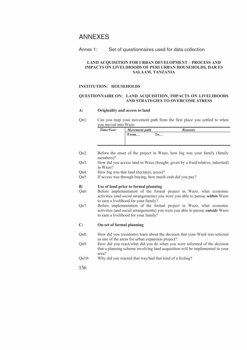
156
ANNEXES Annex 1: Set of questionnaires used for data collection
LAND ACQUISITION FOR URBAN DEVELOPMENT – PROCESS AND IMPACTS ON LIVELIHOODS OF PERI URBAN HOUSEHOLDS, DAR ES
SALAAM, TANZANIA
INSTITUTION: HOUSEHOLDS
QUESTIONNAIRE ON: LAND ACQUISITION, IMPACTS ON LIVELIHOODS AND STRATEGIES TO OVERCOME STRESS
A: Originality and access to land Qn1: Can you map your movement path from the first place you settled to when
you moved into Wazo Time/Year Movement path Reasons
From… To…
Qn2: Before the onset of the project in Wazo, how big was your family (family
members)? Qn3: How did you access land in Wazo (bought, given by a fried/relative, inherited)
in Wazo? Qn4: How big was that land (hectares, acres)? Qn5: If access was through buying, how much cash did you pay? B: Use of land prior to formal planning Qn6: Before implementation of the formal project in Wazo, what economic
activities (and social arrangements) you were you able to pursue within Wazo to earn a livelihood for your family?
Qn7: Before implementation of the formal project in Wazo, what economic activities (and social arrangements) you were you able to pursue outside Wazo to earn a livelihood for your family?
C: On-set of formal planning Qn8: How did you (residents) learn about the decision that your Ward was selected
as one of the areas for urban expansion project? Qn9: How did you react/what did you do when you were informed of the decision
that a planning scheme involving land acquisition will be implemented in your area?
Qn10: Why did you reacted that way/had that kind of a feeling?

157
D: Land acquisition and compensation vis-à-vis policy and legal provisions Qn11: What assets did you possess before the coming of the project that were
eventually acquired in order to give way for the implementation of the project (land, housing, business premises/stalls, working space/garages, livestock/poultry)?
Qn12: How did the loss imposed by acquisition of your assets/properties affected
your life i.e. what aspects of your life were affected?
Lost assets (quantify) Effects to livelihoods arising from the loss
Qn13: How much cash (TShs) did you receive as compensation for the properties
acquired from you? Item Amount of compensation Land House Transport Disturbance Other assets
Qn14: Were you involved in the actual valuation your assets prior to compensation? Qn15: If you were involved in the evaluation of your assets (measuring or counting
of plants etc), give brief description of how you were involved i.e. in what ways?
Qn16: Were you given an alternative resettlement area where you moved to and continue with the livelihood activities you were carrying before?
Qn17: How much time lapsed from the time your properties/assets were assessed/valued to the time you were finally paid?
Qn18: If more than six months lapsed before compensation was paid, was the sum/value recomputed to include an interest rate as provided in the laws?
Qn19: What procedures/formalities you were required to follow in order to get your compensation?
Qn20: Are there cases where the claimants passed away before being paid their compensation dues?
Qn21: What is the most disappointing/frustrating issue regarding the compensation process (and why)?
Qn22: How were the needs and concerns of the vulnerable groups (children, women and disabled) taken into consideration?
Qn23: How were tenants considered in the Wazo project? Qn24: If they were not considered, how were they affected? E: Exploring issues regarding stress – from personal experiences Qn25: What is the size of your new land/plot? Qn26: How much cash did you use/plan to use to build your new house?
158
Qn27: How many years did it take you to build this house? Qn28: What livelihood activities you were able to undertake before the project, but
are no longer possible today i.e. after acquisition?
Livelihood activities before the project that are no longer possible today
Qn29: What new livelihoods activities you are able to undertake after the project but
were not possible before the project? New livelihood activities that were not possible before the project
Qn30: Has your life been affected (experienced any type of stress) because of the
inability to carry out certain livelihood activities? Livelihood activities no longer possible Impacts to life – long and short term
(with remarks)
Qn31: What strategies/measures/tricks did you use to overcome the stress imposed
by loss of livelihoods imposed by acquisition of your assets? Qn32: Overall, how do you assess your life before and after acquisition of your land
for the urban expansion project (either re-gained the quality of life or worsened)?
Qn33: If the quality of your life has improved, how much time (years) did you take to re-gain the quality of life you had before?
F: The way forward Qn34: Describe the weaknesses related to policies, laws and regulations that you
think constitute the main sources of the resistance and complaints from residents when it comes to land acquisition for public use?
Qn35: Describe the weaknesses in the valuation process (practice) that constitute sources of the resistance and complaints from the residents?
Qn36: What should be done (and by whom) in the future in order to ensure that land acquisition for public use does not result to violence and impoverishment of the affected people?
+++++++++++++++++++++++++++++++++++++++++++++++++++++++

159
INSTITUTION: KINONDONI MUNICIPAL COUNCIL-LAND OFFICER
QUESTIONNAIRE ON: GROWTH DYNAMICS AND LAND ACQUISITION FOR URBAN EXPANSION PROJECTS
A: Laws and regulations providing for compulsory land acquisition Qn1: What methods/techniques were used to determine the amount of compensation
that was paid in Wazo (land, houses, crops etc)?
Properties The how’s of valuation process Land House (of permanent building materials)
House (of temporary building materials)
Transport allowance Disturbance allowance
Qn2: What are the options/requirements for one to undertake an independent
valuation of his/her properties for the purpose of compensation? Qn3: What formalities including actors and institutions have to be followed for
certification/validation of valuation results from the field, either by a government or private valuer?
Qn4: Which other countries in the region are allowing private/independent valuation by the affected people?
Qn5: If yes, how? Qn6: If not, why not? Qn7: Do you think it is difficult for the government to adopt the World Bank Policy
which mandatorily requires provision for resettlement land? Qn8: What do you consider to be the most severe negative effects of acquisition of
land for public use in Tanzania? B: Land acquisition for the 20,000 plot project in Wazo Qn9: What were the roles of KMC versus those of the Ministry of Lands in the
different phases of implementation of the 20,000 plot project in Wazo?
Phases When Roles/Activities undertaken KMC Ministry
Qn10: During the land acquisition process in Wazo, how were the needs and concerns
of tenants and the vulnerable groups (children, women, disabled) taken into consideration?
Qn11: What complaints are still persistent despite completion of the project?

160
Qn12: What are the options/requirements for one to undertake an independent valuation of his/her properties for the purpose of compensation?
Qn13: What processes including actors and institutions were to be followed by an affected person in order to get a new plot that is planned and surveyed?
C: Reflections on the laws and regulations vis-à-vis the practice and real life
situation Qn14: What are the WEAKNESSES IN POLICIES, LAWS AND
REGULATIONS governing land acquisition an valuation that constitute the source of resistance and complaints among many residents?
Qn15: What are the MAJOR CHALLENGES/PROBLEMS (IN THE PRACTICE) that surround land acquisition and valuation, and which are the cause for resistance and complaints among many residents?
Qn16: What should be done in the future in order to ensure that land acquisition for public use does not result to violence and impoverishment of the affected people?
+++++++++++++++++++++++++++++++++++++++++++++++++++++++ INSTITUTION: MINISTRY OF LANDS - 20,000 PLOTS PROJECT
QUESTIONNAIRE ON: URBAN EXPANSION AND GOVERNMENT RESPONSES
A: Preparation of the scheme for Wazo, valuation and compensation Qn1: Who prepared the planning scheme that was implemented in Wazo? Qn 2: How many hectares of land (size) was acquired from sitting occupiers that
comprised the project area for the Wazo Scheme? Qn3: How many plots were planned and surveyed in the current/official scheme for
Wazo (residential, commercial, commercial-residential, institutional, industrial, open spaces etc)?
Qn4: How was sensitization/awareness creation particularly prior to land acquisition carried out in Wazo?
Sensitization/awareness creation event
How By whom?
Qn5: How many households were living in the project area and were consequently
affected by implementation of the scheme? Qn6: How many households were subject for complete relocation to give way for
the implementation of the scheme?
161
Qn7: What conditions were laid out by the Ministry as a basis for compensating people variously affected by implementation of the project?
Shamba + house + crops
Shamba + crops Areas in steep slopes (mabondeni)+ house + crops
Alreadysurveyedshamba + house +crops
Relocated Not relocated
Relocated Not relocated
Qn8: What methods/techniques were used to determine the amount of compensation
that was paid in Wazo (land, houses, crops etc)? Properties The how’s of valuation process Land House (of permanent building materials)
House (of temporary building materials)
Transport allowance Disturbance allowance
Qn9: Many complaints exist among majority in Wazo that “land” was not
compensated. The few who have “hati ya fidia” also depict the same. Why only a small proportion of original land owners were compensated?
Qn 10: Majority of those compensated were not issued with “hati ya fidia”, especially for the land aspect. Which criterion was used to determine who should get the “hati ya fidia” and who should not?
Qn11: Several “issues” i.e. second and third generations of TP drawings have been prepared and are being used to sanction re-subdivision of plots already allocated to individuals (an afterthought) and mostly re-allocate the same to immigrants/influential people. What situation/factors prompted for preparation of the second and third generation of TP drawings? And who prepared them?
Qn12: Being the “sole actor” in the Wazo project, how many re-subdivisions (of plots already allocated to individuals) has the Ministry sanctioned to date? And why the afterthought?
Qn13: What formalities including actors and institutions have to be followed for certification/validation of valuation results from the field, either by a government or private valuer?
Qn14: What are the options/requirements for one to undertake an independent valuation of his/her properties for the purpose of compensation?
Qn15: Give a step by step of all the processes including actors and institutions were to be followed (by affected people who lived in Wazo prior to the coming of the project) in order to get a new plot that is planned and surveyed?
Qn 16: How many complaints related to double allocation of plots (original owners viz. immigrants/outsiders) have been reported to the Ministry?

162
B: Involvement residents and other institutions Qn17: What was the role of Ministry versus those of Kinondoni Municipal Council in
different phases of the implementation of the 20,000 plot project?
Phase/component of the scheme
Roles/activities Ministry KMC
Qn18: How were the citizens, Ward and Mtaa leaders of Wazo involved in the
identification of Wazo as a site for the 20,000 plot? Qn19: What criteria were used to identify/pick/select Wazo as one of the areas for the
20,000 plots project? Qn20: How were the citizens, Ward and Mtaa leaders of Wazo involved in the actual
preparation of the planning scheme that was implemented in their area? C: Challenges in implementing urban expansion projects and the way
forward Qn21: What common problems/challenges were encountered in the different phases
of implementation of the project in Wazo? Phase Common problems/challenges Sensitization Plan preparation Valuation Payment of compensation Implementation of the scheme Post implementation (development and development control)
Qn22: Compulsory land acquisition has repeatedly met resistance and spark
complaints from the affected residents. What are the main WEAKNESSES IN POLICIES, LAWS AND REGULATIONS which constitute the main source of the resistance and complaints?
Qn23: Compulsory land acquisition has repeatedly met resistance and spark complaints from the affected residents. What are the main CHALLENGES/PROBLEMS IN THE PRACTICE that constitutes the main source of the resistance and complaints?
Qn24: What are the plans including strategies by the Ministry to identify and reserve land for future urban expansion in the peri urban areas necessary to secure land at minimum cost and with little or no conflicts with the residents? +++++++++++++++++++++++++++++++++++++++++++++++++++++++

163
INSTITUTION: WARD AND MTAA
QUESTIONNAIRE ON: INVOLVEMENT OF WARD AND MTAA IN PROJECT IMPLEMENTATION
A: Wazo and the decision to decision to implement urban expansion project Qn1: How big (km2) is the total area of the Ward? Qn2: In accordance to any recent census (National or Ward), what is the total
population of the Ward? Qn3: How many Mitaa comprise the Ward with their respective population? Qn4: In accordance to any recent census (National or Ward), how many households
comprise the Ward? Qn5: Understandably, Wazo was once a Mtaa within Kunduchi Ward; but was
recently accorded a Ward status. What factors warranted designation of Wazo as a full-fledged Ward?
Qn6: What constitute the main economic activities of the residents in the Ward? Qn7: Being one of the Wards where the 20,000 plots project meant to accommodate
urban expansion was implemented, were you involved to make the decision that selected it as one of the project areas?
Qn8: If you were involved to make that decision; how were you involved/influenced the decision?
Qn9: What criteria were used to identify/pick/select Wazo as one of the areas for the 20,000 plots project?
B: Policy, legislations and institutional issues Qn10: Are you aware of any specific provisions of the laws, policies or regulations
that provides for land acquisition for public use in the country? Qn11: Was the Ward institution involved to calculate/determine the value of
properties of the residents for compensation purposes? Qn12: If yes, how was it involved (give a step by step description of how you were
involved in the undertaking of the valuation exercise (value derivication)) Qn13: Were there other institutions (and their respective actors) that were involved in
the process of undertaking valuation exercise for the affected people? Qn14: If there were other institutions involved, what specific roles/activities they
undertook? C: Project implementation, compensation and relocation Qn15: The 20,000 plots project was implemented in how many Mitaa within the
Ward? Qn16: How many families/households their land and other assets were acquired to
give way for the implementation of the project? Qn17: Were the people/households affected by implementation of the project
compensated? Qn18: If they were compensated, how many were they i.e. finally got compensated?

164
Qn19: If they were compensated, what was compensated? Qn20: What mode of payment was used to pay the affected residents? Qn21: In addition to monetary compensation (the de-facto mode of compensation in
Tanzania), what other forms of compensation packages were given/paid? Qn22: Were there any snags/bureaucracies that shrouded payment of compensation
fund? Qn23: If yes, what were these? Qn24: How were the bureaucracies/snags overcome? Qn25: Were there any incidences where people gave up following their compensation
funds? Qn26: Were there incidences where people died while still in the process of following
up their compensation funds? Qn27: During compensation process, were there any people who given alternative
plots within the Ward in addition to monetary compensation? Qn28: In the course of implementation of the scheme, were there people who got
relocated outside the Ward? Qn29: If there were people who were given alternative plots in addition to monetary
compensation, what factors/criteria were used to determine who (in addition to monetary compensation) were to get an alternative plot within the ward or would have to move outside the ward?
Qn30: During the land acquisition process in Wazo, were the vulnerable groups (children, women, disabled) given any special consideration?
Qn31: Tenants have often been the “forgotten victims” in terms of their displaced livelihoods in these kinds of projects. Were tenants considered in the Wazo project in respect of compensation for loss of livelihoods and other assets they possessed?
D: Livelihoods activities prior to formal planning Qn32: After land was acquired from the people and the scheme implemented, are
there any livelihoods activities that the residents are able to undertake now that were not possible before their land was acquired?
Qn33: Before land was acquired from the people, were there any activities that the residents were able to undertake but are no longer possible today i.e. after acquisition?
Qn34: After land acquisition, is there any improvement in the social and economic welfare of the residents?
Qn35: If there are improvements, give a brief description of the type/nature of the improvement.
E: Complaints against valuation and compensation Qn36: Specifically for Wazo, were there any complaints were filed in the courts of
law against the outcomes of the valuation exercise?

165
Qn37: If yes, what types of complaints were lodged i.e. complaints against what aspects of either acquisition, valuation of properties or payment of compensation?
Qn38: If cases were lodged in the court of law (above), have they been determined/resolved to date?
Qn39: If they have already been determined, how many were determined in favor of the government authorities (Ministry and the Municipality)?
Qn40: Out of the cases filed in the court of law above, how many were determined in favor of the affected residents?
F: Weaknesses, challenges and the way forward Qn41: What are the inherent weaknesses and/or strengths in policies, laws and
regulations governing the undertaking of valuation that are a source of the resistance and complaints?
Qn42: What are the inherent weaknesses and/or strengths in the practice of undertaking valuation exercise that are a source of the resistance and complaints?
Qn43: What should be done in the future in order to ensure that land acquisition for public use does not result to violence and impoverishment of the affected people?

Annex
2:
Sele
ction o
f case s
tud
y are
a in D
ar
es S
ala
am
Ch
ara
cteri
stic
s M
un
icip
aliti
es
Tem
eke
Pu
rpo
se o
f sc
hem
e
Ilala
P
urp
ose
of
sch
em
e
Kin
on
do
ni
Pu
rpo
se o
f sc
hem
e
Urb
an w
ards
San
dal
i
Kar
iako
o
M
agom
eni
Kek
o
Ja
ngw
ani
M
akuru
mla
M
akan
gar
awe
U
pan
ga
Mas
har
iki
N
dungum
bi
M
toni
U
pan
ga
Mag
har
ibi
Tan
dal
e
Chan
g’o
mbe
Kis
utu
Mw
anan
yam
ala
M
bag
ala
M
chaf
uko
ge
M
sasa
ni
Mbag
ala
Kuu
G
erez
ani
Kin
ondoni
Yom
bo V
ituka
Ilal
a
Mzi
muni
Kig
am
boni
M
chik
ichin
i
Kig
ogo
Char
ambe
Kiv
uko
ni
M
abib
o
Mib
ura
ni
Buguru
ni
M
anze
se
Azi
mio
Ubungo
Tem
eke
Kaw
e
Kura
sini
M
akuburi
Tan
dik
a
M
bura
hati
Mak
um
bush
o
Sin
za
Kijitonya
ma
Kim
ara
Mik
och
eni
Han
na
Nas
sif
Pe
ri U
rban
(M
ixed
) w
ard
s Vijib
wen
i
Kin
yere
zi
Land U
se P
lannin
g
Sch
eme
Imple
men
ted
Kib
am
ba
Lugulu
ni Sate
llite
Tow
n
Kib
ada
20,0
00plo
ts P
roje
ct
Pugu
Kunduch
i 20,0
00 p
lots

Ch
ara
cteri
stic
s M
un
icip
aliti
es
Tem
eke
Pu
rpo
se o
f sc
hem
e
Ilala
P
urp
ose
of
sch
em
e
Kin
on
do
ni
Pu
rpo
se o
f sc
hem
e
(Miv
um
oni)
Tuan
gom
a
20,0
00plo
ts P
roje
ct
Chan
ika
Land U
se P
lannin
g
Sch
eme
Imple
men
ted
Bunju
20,0
00plo
ts P
roje
ct
and M
abw
epan
de
Res
ettlem
ent
schem
e
Waz
o
20,0
00 P
lots
pro
ject
Mab
wep
ande
20,0
00 P
lots
pro
ject
Kw
embe
20,0
00 P
lots
pro
ject
Mbw
eni
20,0
00 P
lots
pro
ject
Goba
Cham
azi
U
konga
M
bez
i
M
jim
wem
a
20,0
00plo
ts P
roje
ct
Tab
ata
Seg
erea
Kiw
ala
ni
Kip
awa
Kitunda
Mso
ngola
Vin
gunguti
Pe
ri-u
rban w
ards
Som
angira
Kim
biji
Pem
ba
Mnaz
i
Kis
araw
e II
Sour
ce: L
itera
ture
revi
ew a
nd fi
eld
stud
ies (
2010
)
Not
e th
at: F
or K
inon
doni
Mun
icip
ality
; Waz
o M
abw
epan
de a
nd K
wem
be w
ere
new
War
ds e
stab
lishe
d in
ear
ly 2
010.
The
y w
ere
initi
ally
M
taa
area
s with
in K
undu
chi,
Bun
ju a
nd K
ibam
ba W
ards
resp
ectiv
ely.

Annex
3:
Case s
tud
y sele
ction
Ward
M
taa w
ith
sch
em
es
Co
mp
en
sati
on
statu
s R
elo
cati
on
statu
s Eco
no
mic
act
ivit
iess
S
oci
o-
eco
no
mic
statu
s
Ho
usi
ng
con
dit
ion
R
em
ark
s fo
r ca
sese
lect
ion
M
taa
Year
start
ed
Waz
o
In K
isan
ga
and
Miv
um
oni
�In
2002/0
3
�Six
blo
cks-
surv
eyed
(b
lock
s 1 -
3
and p
art
of
blo
ck 4
in
Kis
anga
while
blo
cks
5 -
6
and p
art
of
blo
ck 4
in
Miv
um
oni)
�Com
pen
satio
n s
tart
ed t
o
be
pai
d in
2002 a
nd
com
ple
ted in
2003
�H
ouse
s th
at
fitt
ed in t
he
layo
ut
wer
e re
tain
ed
�Com
pen
satio
n a
ssoci
ated
w
ith
com
pla
ints
- -
lodgin
g o
f co
urt
cas
es
agai
nst
in
adeq
uat
e co
mpen
sation
�About
1,0
00
peo
ple
af
fect
ed b
y th
e pro
ject
; m
ajority
of
the
affe
cted
peo
ple
still
livin
g in t
he
area
to d
ate
i.e.
rel
ocat
ed
in B
lock
3 in
Kis
anga
�San
d m
inin
g,
�Cru
shin
g
stones
, �
Pett
y tr
adin
g,
�Sm
all-
scal
e fa
rmin
g
�Ext
ensi
ve
anim
al
keep
ing
�O
ffic
ial
emplo
ymen
t.
�M
ajori
ty
are
mid
dle
an
d low
in
com
e peo
ple
.
�M
ost
ly
low
qual
ity
and
som
eho
w w
ith
hig
h
occ
upat
ion
den
sity
�
Good
house
s pro
gre
ssi
vely
built
by
alie
ns.
�O
ver
8 y
ears
sin
ce lan
d
was
acq
uired
and
com
pen
sation p
aid
�Pr
esen
ce o
f m
any
of th
e af
fect
ed p
eople
within
th
e pro
ject
are
a �
Com
ple
ted
com
pen
sation o
ver
8
year
s ag
o;
�D
iver
se e
conom
ic
activi
ties
�
CO
NCLU
SIO
N
�Le
vel 1 s
elec
tion
�
In 2
out
of th
e 6M
taa
area
s �
An o
ld p
roje
ct
Chan
ika
In
Kig
ezi
and Z
aval
a M
taa
area
s
�All
in o
ne
Phas
e in
2002/0
3
�Com
pen
satio
n p
aid t
o a
ll af
fect
ed
peo
ple
in
2003/0
4.
�About
1000
peo
ple
(a
bout
200
hhds)
wer
e af
fect
ed
�M
any
relo
cate
d in
Zav
ala
and
Kig
ezi M
taa
area
s in
Buyu
ni.
�Sm
all sc
ale
farm
ing
within
the
War
d (
cash
cr
ops,
food
crops,
and
pet
ty,
�Sm
all sc
ale
anim
al
keep
ing
�San
d m
inin
g
activi
ties
�O
vera
ll,
origin
al
sett
lers
are
poore
r co
mpar
ed
to
imm
igra
nts
, �
Most
origin
al
sett
lers
en
gag
e in
ca
sual
la
bou
r i.e.
�G
ood
qual
ity
and
expen
siv
e house
s built
by
alie
ns,
�
House
s of m
ost
origin
al
sett
lers
ar
e built
of
tem
pora
�O
ver
8 y
ears
sin
ce lan
d
was
acq
uired
, �
Most
of th
e af
fect
ed
peo
ple
rel
oca
ted w
ithin
th
e w
ard,
espec
ially
Buyu
ni ar
ea (
Kig
ezi an
d
Zav
ala)
, �
Paym
ent
of
com
pen
sation
com
ple
ted o
ver
6 y
ears
ag
o;
�D
iver
se e
conom
ic
activi
ties

Ward
M
taa w
ith
sch
em
es
Co
mp
en
sati
on
statu
s R
elo
cati
on
statu
s Eco
no
mic
act
ivit
iess
S
oci
o-
eco
no
mic
statu
s
Ho
usi
ng
con
dit
ion
R
em
ark
s fo
r ca
sese
lect
ion
M
taa
Year
start
ed
atte
ndin
g
farm
s,
wat
chm
en
etc.
ry
mat
eria
ls;
but
slow
ly
upgra
din
g.
�CO
NCLU
SIO
N
�Le
vel 1 s
elec
tion
�
In 2
out
of th
e 15 M
taa
area
s �
An o
ld p
roje
ct
Kin
yere
zi
Kin
yere
zi
and K
ifuru
M
taa
Are
as
�Ph
ase
I:
Songas
(1
996);
�
Phas
e II
:-M
LHH
SD
and
IMC-(
1997);
�
Phas
e II
I:
(1999);
�
Phas
e IV
: (1
999)
�Kin
yere
zi
Mta
a Are
a:
Com
pen
satio
n c
om
ple
ted
2001/2
002
�Kifuru
Mta
a Are
a: F
irst
Phas
e co
mpen
satipa
id in 1
999,
seco
nd p
has
e pay
men
t st
ill
in p
rogre
ss
�Com
pla
ints
on d
elay
ed
pay
men
t,
also
in
adeq
uat
e co
mpen
sation
�Kin
yere
zi
Mta
a ar
ea:
50 p
erce
nt
relo
cate
d
within
the
War
d,
the
rem
ainin
g in
Chan
ika,
�
Kifuru
Mta
a ar
ea:
Land
acquis
itio
n
not
yet,
Ila
la
Munic
ipal
Counci
l st
ill
mobili
sing
funds
to p
ay
com
pen
satio
n
�As
such
, peo
ple
are
st
ill
occ
upyi
ng
thei
r ar
eas
(not
relo
cate
d
yet)
�Sm
all/
reta
il busi
nes
ses
�
Gar
den
ing
�Sm
all sc
ale
anim
al
keep
ing
�O
ffic
ial
emplo
ymen
t
�Kin
yere
zi
Mta
a ar
ea:
Maj
ori
ty
are
imm
igra
nts
an
d a
re
wel
l-off;
most
of
thes
e ar
e em
plo
yees
in
the
city
ce
ntr
e �
Origin
al
sett
lers
are
fe
w a
nd a
re
gen
eral
ly
poor
�Kifuru
Mta
a ar
ea:
Maj
ori
ty
are
poor
�Kin
yere
zi
Mta
a ar
ea:
�Exp
ensi
ve build
ings
incl
udin
g
multi-
store
y build
ings
�Kifuru
M
taa
area
: �
Spar
sely
built
�W
ith a
n e
xcep
tion
of
Kifuru
Mta
a ar
eas,
the
rest
wer
e ac
quis
itio
n for
the
Songoso
ngo g
as
pip
elin
e (1
999)
and
expan
sion o
f el
ectr
icity
mai
n lin
e (1
997);
�
In K
inye
rezi
Mta
a ar
ea:
Ove
r 11 t
o 1
4 y
ears
si
nce
lan
d w
as
acquired
; Pr
esen
ce o
f m
any
of th
e af
fect
ed
peo
ple
within
the
pro
ject
are
a; a
nd
Com
ple
ted
com
pen
sation o
ver
8
year
s ag
o,
�D
iver
sity
of ec
onom
ic
activi
ties
�CO
NCLU
SIO
N
�Le
vel 1 s
elec
tion
�
In o
ne
of th
e tw
o pro
ject
are
as,
8 y
ears
hav
e la
pse
d s
ince
co
mpen
sation p
aid a
nd
land w
as a
cquir
ed
�Kifuru
pro
ject
is
very
re
cent
and p
eople
hav
e
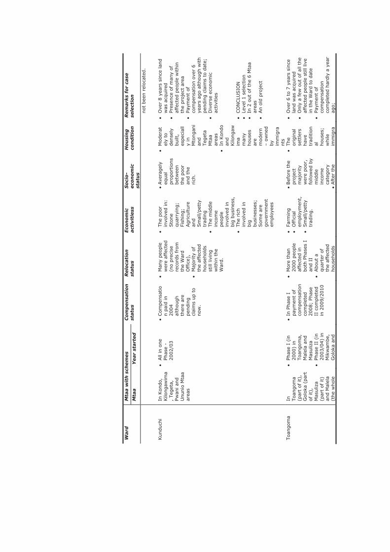
Ward
M
taa w
ith
sch
em
es
Co
mp
en
sati
on
statu
s R
elo
cati
on
statu
s Eco
no
mic
act
ivit
iess
S
oci
o-
eco
no
mic
statu
s
Ho
usi
ng
con
dit
ion
R
em
ark
s fo
r ca
sese
lect
ion
M
taa
Year
start
ed
not
bee
n r
eloca
ted.
Kunduch
i In
Kondo,
Kilo
ngaw
ima
, Teg
eta,
Pw
ani an
d
Ununio
Mta
a ar
eas
�All
in o
ne
Phas
e -
2002/0
3
�Com
pen
satio
n p
aid in
2004
alth
ough
ther
e ar
e pen
din
g
clai
ms
up t
o
now
.
�M
any
peo
ple
w
ere
affe
cted
(n
o p
reci
se
reco
rds
from
th
e W
ard
Offic
e),
�M
ajority
of
the
affe
cted
house
hol
ds
still
liv
ing
within
the
War
d.
�The
poor
in
volv
ed in:
Sto
ne
quar
ryin
g;
Fish
ing;
Agricu
lture
an
d
Sm
all/
pet
ty
trad
ing
�The
mid
dle
in
com
e peo
ple
in
volv
ed in
big
busi
nes
s,
�The
rich
in
volv
ed in
big
busi
nes
ses;
Som
e ar
e gove
rnm
ent
emplo
yees
�Ave
ragel
y eq
ual
pro
port
ions
bet
wee
n
the
poor
an
d t
he
rich
.
�M
oder
atel
y to
den
sely
built
, es
pec
iall
y in
M
tongan
i an
d
Teg
eta
Mta
a ar
eas
�In
Kondo
and
Kilo
ngaw
ima
man
y house
s ar
e m
oder
n
– o
wned
by
imm
igra
nts
�O
ver
8 y
ears
sin
ce lan
d
was
acq
uired
�
Pres
ence
of m
any
of
affe
cted
peo
ple
within
th
e pro
ject
are
a
�Pa
ymen
t of
com
pen
sation o
ver
6
year
s ag
o a
lthough w
ith
pen
din
g c
laim
s to
dat
e;
�D
iver
se e
conom
ic
activi
ties
�
CO
NCLU
SIO
N
�Le
vel 1 s
elec
tion
�
In 2
out
of th
e 6 M
taa
area
s �
An o
ld p
roje
ct
Toan
gom
a In
Toan
gom
a (p
art
of it),
G
oloka
(par
t of it),
M
asuliz
a (p
art
of it)
and M
alel
a (t
he
whol
e
�Ph
ase
I (i
n
2000)
in
Toan
gom
a,
Mal
ela
and
Mas
uliz
a �
Phas
e II
(in
2003/0
4)
in
Mik
wam
be,
G
oloka
and
�In
Phas
e I
pay
men
t of
com
pen
sation
com
ple
ted
2008;
Phas
e II
com
ple
ted
in 2
009/2
010
�M
ore
than
2000 p
eople
af
fect
ed in
both
Phas
es I
an
d I
I �
About
a quar
ter
of
the
affe
cted
house
hol
ds
�Fa
rmin
g
�O
ffic
ial
emplo
ymen
t,
�Sm
all/
pet
ty
trad
ing.
�Bef
ore
the
pro
ject
m
ajority
w
ere
poor
, fo
llow
ed b
y m
iddle
in
com
e ca
tegory
�
Aft
er t
he
�The
origin
al
sett
lers
hav
e tr
aditio
nal
house
s;
while
im
mig
ra
�O
ver
6 t
o 7
yea
rs s
ince
la
nd w
as a
cquir
ed
�O
nly
a few
out
of al
l th
e af
fect
ed p
eople
still
live
in t
he
War
d t
o d
ate
�Pa
ymen
t of
com
pen
sation
com
ple
ted h
ardly
a y
ear
ago;

Ward
M
taa w
ith
sch
em
es
Co
mp
en
sati
on
statu
s R
elo
cati
on
statu
s Eco
no
mic
act
ivit
iess
S
oci
o-
eco
no
mic
statu
s
Ho
usi
ng
con
dit
ion
R
em
ark
s fo
r ca
sese
lect
ion
M
taa
Year
start
ed
Mta
a)
Mas
uliz
a re
loca
ted
within
the
War
d,
but
sold
and
move
s to
unpla
nned
ar
eas
bec
ause
they
w
ere
unab
le
to m
eet
dev
elop
men
t co
nditio
ns.
pro
ject
, a
lot
of w
ell-
off
peo
ple
m
ove
d into
th
e W
ard;
thes
e outn
um
ber
th
e poor
.
nts
hav
e m
oder
n
house
s �
Toan
go
ma,
M
zinga
and
Kongow
e M
taa
area
s hea
vily
popula
ted
�D
iver
se e
conom
ic
activi
ties
�
CO
NCLU
SIO
N
�Le
vel 2 s
elec
tion
�
In 4
out
of th
e 12 M
taa
area
s �
An o
ld p
roje
ct
Mbw
eni
All
the
thre
e M
taa
area
s i.e.
Mbw
eni,
Mpiji an
d
Map
uto
�All
in o
ne
phas
e (2
002/0
3)
�Pai
d d
uring
the
sam
e per
iod,
2003
�Surv
eyin
g
exer
cise
av
oid
ed
den
sely
occ
upie
d
area
s.
�About
200
peo
ple
af
fect
ed
�About
10
per
cent
of
affe
cted
peo
ple
re
loca
ted in
Mbw
eni
Teg
eta
and
Ubungo)
within
the
War
d
�N
o
house
hol
ds
relo
cate
d
outs
ide
the
War
d
�M
ajori
ty a
re
fish
erm
en
(Mbw
eni,
Map
uto
and
Mpiji M
taa
area
s),
�Sm
all/
pet
ty
trad
ing,
�Anim
al
husb
andry
, �
Sto
ne-
crush
ing
�San
d m
inin
g
(in M
aputo
M
taa
area
),
�Fa
rmin
g/a
gri
culture
ac
tivi
ties
(M
aputo
and
Mpiji M
taa
area
s)
�M
ajori
ty
are
poor
�
Follo
wed
by
mid
dle
ca
tegories
�The
war
d is
still
sp
arse
ly
built
’ �
Man
y house
s of
origin
al
sett
lers
ar
e built
of
trad
itio
nal
m
ater
ial
s �
A few
of
the
imm
igra
nts
hav
e m
oder
n
house
s
�O
ver
7 y
ears
sin
ce lan
d
was
acq
uired
, �
Most
of th
e af
fect
ed
peo
ple
rel
oca
ted w
ithin
th
e w
ard
�Pa
ymen
t of
com
pen
sation
com
ple
ted o
ver
7 y
ears
ag
o;
�Le
ss d
ynam
ic e
conom
ic
activi
ties
�
CO
NCLU
SIO
N
�Le
vel 2 s
elec
tion
�
In 3
out
of th
e 6 M
taa
area
s �
An o
ld p
roje
ct

Ward
M
taa w
ith
sch
em
es
Co
mp
en
sati
on
statu
s R
elo
cati
on
statu
s Eco
no
mic
act
ivit
iess
S
oci
o-
eco
no
mic
statu
s
Ho
usi
ng
con
dit
ion
R
em
ark
s fo
r ca
sese
lect
ion
M
taa
Year
start
ed
Kib
ada
In
Nya
kwal
e,
Kiz
iza,
Soko
ni an
d
Kic
han
gan
Mta
a ar
eas
�Tw
o P
has
es:
Phas
e I-
in
Kic
han
gan
i in
2006;
and
Phas
e II
-
Sam
e ye
ar
(2006)
in
Nya
kwal
e,
Kiz
iza
and
Soko
ni
�M
ajori
ty
alre
ady
bee
n
com
pen
sate
d
since
2007.
�M
ore
than
4000 p
eople
af
fect
ed b
y th
e pro
ject
�
Alm
ost
3 o
ut
of ev
ery
10
affe
cted
peo
ple
re
mai
n in t
he
origin
al lan
d.
�Fa
rmin
g,
�Anim
al
keep
ing
�Sm
all/
reta
il busi
nes
ses,
�
Cas
ual
la
bor
ing
�Im
mig
rants
ar
e gen
eral
ly
wel
l off.
Thes
e ar
e buyi
ng o
ff
the
origin
al
inhab
itan
ts.
�Bef
ore
lan
d
acquis
itio
n
the
inhab
itan
ts
wer
e bet
ter
off s
oci
ally
an
d
econom
ical
ly,
but
afte
r la
nd
acquis
itio
n
they
hav
e bec
ome
poore
r.
�Big
ch
unks
of la
nd
undev
elo
ped
– o
n
the
han
ds
of
abse
nte
e ow
ner
s
�O
ver
2 t
o 3
yea
rs s
ince
la
nd w
as a
cquir
ed
�Pr
esen
ce o
f m
any
of th
e af
fect
ed p
eople
within
th
e pro
ject
are
a an
d in
unsu
rvey
ed p
arts
of th
e w
ard
�Pa
ymen
t of
com
pen
sation
com
ple
ted s
ince
2 y
ears
ag
o;
�D
iver
se e
conom
ic
activi
ties
�
CO
NCLU
SIO
N
�Le
vel 3 s
elec
tion
�
In 4
out
of th
e 6 M
taa
area
s �
A r
ecen
t pro
ject
Kw
embe
In t
hre
e out
of five
Mta
a ar
eas.
Thre
e pro
ject
s ar
e on-g
oing.
�Lu
guru
ni
Sat
ellit
e Tow
n p
roje
ct
(in L
uguru
ni
Cen
tre)
st
arte
d in
2007
�Lu
guru
ni
Land U
se
Plan
nin
g
pro
ject
(o
uts
ide
the
Luguru
ni
�Lu
guru
ni
Sat
ellit
e Tow
n p
roje
ct
com
pen
sation
done
in
2009;
albei
t w
ith
com
pla
ints
�
Luguru
ni
Land U
se
Plan
nin
g
pro
ject
in
volv
ed n
o
�Lu
guru
ni
Sat
ellit
e Tow
n p
roje
ct
affe
cted
ab
out
250
peo
ple
–
About
99
per
cent
of
thes
e m
ove
d
outs
ide
the
war
d
�Lu
guru
ni
�M
ost
ly
farm
ing,
�Anim
al
keep
ing,
�San
d m
inin
g,
�Pe
tty
trad
ing/s
mal
l sc
ale
busi
nes
s ac
tivi
ties
�M
ost
ly low
an
d m
iddle
in
com
e ea
rner
s
�Lu
guru
ni
Mta
a ar
ea is
den
sely
dev
elop
ed
espec
iall
y at
the
centr
e,
�The
rest
of th
e M
taa
area
s is
�La
nd a
lrea
dy
acquired
fo
r tw
o p
roje
cts
(Luguru
ni Sat
ellit
e Tow
n a
nd K
wem
be
600
plo
ts)
�O
ver
2 y
ears
sin
ce lan
d
was
acq
uired
in
Luguru
ni an
d 2
yea
rs
since
lan
d w
as a
cquir
ed
in K
wem
be
�Com
pen
sation for
Lu
guru
ni pro
ject
pai
d in
2009;
while
for

Ward
M
taa w
ith
sch
em
es
Co
mp
en
sati
on
statu
s R
elo
cati
on
statu
s Eco
no
mic
act
ivit
iess
S
oci
o-
eco
no
mic
statu
s
Ho
usi
ng
con
dit
ion
R
em
ark
s fo
r ca
sese
lect
ion
M
taa
Year
start
ed
Cen
tre)
st
arte
d s
ince
2007
�The
600 p
lots
pro
ject
st
arte
d s
ince
2008
acquis
itio
n,
hen
ce n
o
com
pen
sation
pai
d
�The
600 p
lot
pro
ject
(in
Kw
embe
and
Mpak
ani)
pay
men
t of
com
pen
sation
is s
till
on-
goin
g
Land U
se
Plan
nin
g
pro
ject
af
fect
ed
about
1,0
00
peo
ple
. N
o
relo
cation a
s la
nd w
as n
ot
acquir
ed
�The
600 p
lot
pro
ject
af
fect
ed
about
120
peo
ple
, m
ost
ab
sente
e la
nd o
wner
s;
so t
her
e is
no
relo
cation.
spar
sely
built
, �
Most
house
s (e
xcep
t at
Lu
guru
ni
centr
e)
are
of
low
qual
ity.
Kw
embe
600 p
lot
pro
ject
com
pen
sation
was
pai
d s
ince
2 y
ears
ag
o
�O
ver
99 p
erce
nt
of
affe
cted
peo
ple
in
Luguru
ni m
ove
d a
nd r
e-se
ttle
outs
ide
the
War
d;
and 9
0 p
erce
nt
of t
hose
af
fect
ed b
y 600 p
lot
pro
ject
for
Kw
embe
relo
cate
d w
ithin
the
war
d
�Le
ss d
iver
se e
conom
ic
activi
ties
�
CO
NCLU
SIO
N
�Le
vel 4 s
elec
tion
�
In 3
out
of th
e 5 M
taa
area
s �
Ver
y re
cent
pro
ject
Bunju
Bunju
“A”
and
Kilu
ngule
M
taa
area
s
�Bunju
“A”
done
in t
wo
phas
es:
Phas
e I
in
2003:
In
Bunju
Bea
ch;
and P
has
e II
in
2009 in
Kilu
ngule
.
�Bunju
“A”
Mta
a Are
a:
�Bunju
Bea
ch
in B
unju
“A”
com
pen
sation
com
ple
ted
2003
�Kilu
ngule
M
taa
Are
a:
�Ph
ase
II :
La
nd n
ot
acquir
ed,
no
com
pen
sation
�Bunju
“A”
Mta
a Are
a:
�Ph
ase
I ab
out
700 t
o 8
00
peo
ple
wer
e af
fect
ed.
Out
of th
ese,
ar
ound 4
00
wer
e liv
ing
within
the
area
�
Kilu
ngule
M
taa
Are
a:
�Fa
rmin
g
activi
ties
�
Cru
shin
g
stones
�
San
d m
inin
g,
�O
ffic
ial
emplo
yees
, �
Pett
y/sm
all
scal
e busi
nes
s ac
tivi
ties
�M
ajori
ty
are
poor
,
�Fo
llow
ed b
y th
e m
iddle
cl
ass
cate
gory
�M
oder
atel
y built
cl
ose
to
the
mai
n
road
; an
d
spar
sely
built
to
war
ds
the
inner
ar
eas
�M
oder
ate
qual
ity
-
�La
nd a
cquired
in B
unju
“A
”, w
hile
in K
ilungule
not
yet
acquired
, �
Ove
r 8 y
ears
sin
ce lan
d
was
acq
uired
in B
unju
“A
” w
hile
in K
ilungule
not
yet
acquired
�
Man
y of th
e af
fect
ed
peo
ple
found w
ithin
the
unpla
nned
par
t of
Bunju
�
Paym
ent
of
com
pen
sation
com
ple
ted in B
unju
“A”
ove
r 7 y
ears
ago;
while

Ward
M
taa w
ith
sch
em
es
Co
mp
en
sati
on
statu
s R
elo
cati
on
statu
s Eco
no
mic
act
ivit
iess
S
oci
o-
eco
no
mic
statu
s
Ho
usi
ng
con
dit
ion
R
em
ark
s fo
r ca
sese
lect
ion
M
taa
Year
start
ed
pai
d y
et
�Ph
ase
II:
Land n
ot
acquir
ed,
hen
ce n
o
com
pen
satio
n p
aid
moder
n
const
ruc
tion
mat
eria
ls.
in K
ilungule
not
yet
effe
cted
�
Moder
atel
y div
erse
ec
onom
ic a
ctiv
itie
s �
CO
NCLU
SIO
N
�Le
vel 4 s
elec
tion
�
In 2
out
of th
e 6 M
taa
area
s �
An o
ld p
roje
ct
Mab
wep
ande
Mab
wep
and
e an
d B
unju
“B
”
�In
M
abw
epan
de
done
in T
hre
e phas
es:
Phas
e I:
2008;
Phas
e II
: ea
rly
2009,
and
Phas
e II
I:
2010 (
on-
goin
g)
�Bunju
“B”
done
in o
ne
phas
e (2
003)
�M
abw
epan
de:
50 p
erce
nt
hav
e bee
n
com
pen
sate
d
(but
none
has
bee
n
relo
cate
d);
co
mpla
ints
st
ill e
xist
,
�Bunju
“B”:
�
Com
pen
satio
n c
om
ple
ted
2003
�In
M
abw
epan
de
no r
eloca
tion
has
tak
en
pla
ce,
�Bunju
“B”
�50 p
erce
nt
wer
e liv
ing in
Bunju
-
relo
cate
d
within
the
unpla
nned
par
ts o
f th
e W
ard
�In
M
abw
epan
de
: M
ost
ly
farm
ing
activi
ties
; Sm
all re
tail
shops;
Pet
ty
trad
ing;
San
d m
inin
g
and C
asual
la
bor
ing
�In
Bunju
“B”:
N
o far
min
g,
Most
ly s
mal
l re
tail
busi
nes
s;
Sm
all sc
ale
fish
ing a
nd
San
d m
inin
g
�In
M
abw
epan
de:
Maj
ority
(w
ho a
re
also
origin
al
sett
lers
) ar
e poor
�
Bunju
“B”
�M
ajori
ty
are
poor
, �
Imm
igra
nts
ar
e rich
an
d m
any
are
still
liv
ing a
way
�In
M
abw
epan
de:
Spar
sely
built
; Tra
ditio
nal
m
ater
ial
s an
d
vast
ch
unks
of la
nd
un-
undev
elo
ped
,
�In
Bunju
“B
”:
Spar
sely
built
in
the
pro
ject
ar
ea,
while
den
sely
�La
nd c
om
pen
sate
d in
Mab
wep
ande
but
not
acquir
ed,
hen
ce n
o
relo
cation h
as t
aken
pla
ce.
In B
unju
lan
d
acquir
ed a
nd p
eople
re
loca
ted w
ithin
unpla
nned
par
ts o
f Bunju
�
In M
abw
epan
de
land
rece
ntly
acquired
while
in
Bunju
“B”
acquired
m
ore
than
7 y
ears
ago
�In
com
ple
te
com
pen
sation in
Mab
wep
ande;
while
in
Bunju
“B”
com
pen
sation
was
com
ple
ted in 2
003
�N
one-
div
erse
ran
ge
of
econom
ic a
ctiv
itie
s �
CO
NCLU
SIO
N
�Le
vel 4 s
elec
tion

Ward
M
taa w
ith
sch
em
es
Co
mp
en
sati
on
statu
s R
elo
cati
on
statu
s Eco
no
mic
act
ivit
iess
S
oci
o-
eco
no
mic
statu
s
Ho
usi
ng
con
dit
ion
R
em
ark
s fo
r ca
sese
lect
ion
M
taa
Year
start
ed
built
w
ithin
th
e unpla
nn
ed p
art
of Bunju
“B
” M
jim
wem
a In
all
the
four
Mta
a ar
eas
nam
ely
Mjim
wem
a,
Maw
eni,
Kib
ugum
o
and
Ungin
doni
�D
one
in o
ne
phas
e in
M
jim
wem
a (2
008)
�Com
pen
satio
n n
ot
yet
effe
cted
as
valu
atio
n a
nd
surv
ey w
ork
is
in p
rogre
ss
�N
o r
eloca
tion
so far
bec
ause
the
exer
cise
has
ju
st s
tart
ed
�Fi
shin
g,
�Pe
tty
trad
ing
(Mjim
wem
a an
d M
awen
i)
�Anim
al
keep
ing a
nd
stone
crush
ing -
(M
jim
wem
a,
Maw
eni,
�Fa
rmin
g in
Maw
eni,
Kib
ugum
o �
Tourist
guid
ing-
Kib
ugum
o
and
Ungin
doni
�W
ard is
most
ly
occ
upie
d b
y im
mig
rants
, �
Origin
al
sett
lers
in
crea
singly
bought
off
by
the
affluen
t
�M
ost
ly
low
qual
ity
house
s am
ong
the
origin
al
sett
lers
in
Kib
ugum
o,
�M
ost
im
mig
rants
hav
e ve
ry
good
house
s �
The
War
d is
gen
eral
ly
spar
sely
built
�La
nd n
ot
acquired
�
Peo
ple
not
relo
cate
d
�N
o c
ompen
sation h
as
bee
n p
aid
�Li
fe c
ontinue
as u
sual
w
ith p
eople
occ
upyi
ng
and u
sing t
hei
r la
nd
�D
iver
se e
conom
ic
activi
ties
�
CO
NCLU
SIO
N
�N
ot
goo
d for
a ca
se
Kib
amba
In a
ll th
e five
Mitaa
ar
eas
- Kib
amba,
G
ogoni,
Kilu
vya,
�Sta
rted
in
Kib
amba
Mta
a ar
ea in
2007 b
ut
now
ex
tended
to
the
whol
e
�N
o lan
d w
as
acquir
ed fro
m
ow
ner
s; a
s su
ch n
o
peo
ple
hav
e bee
n
�N
o o
ne
was
re
loca
ted
�M
ost
ly p
etty
tr
adin
g,
�O
ffic
ial
emplo
yees
(t
hes
e ar
e m
ajority
),
�Big
ges
t per
cent
com
prise
of
mid
dle
in
com
e peo
ple
�The
centr
e i.e.
Kib
amba
Mta
a ar
ea is
�La
nd h
as n
ot
bee
n
acquir
ed
�N
o o
ne
has
bee
n
relo
cate
d,
hen
ce t
her
e ar
e no p
eople
who h
ave
bee
n a
ffec
ted
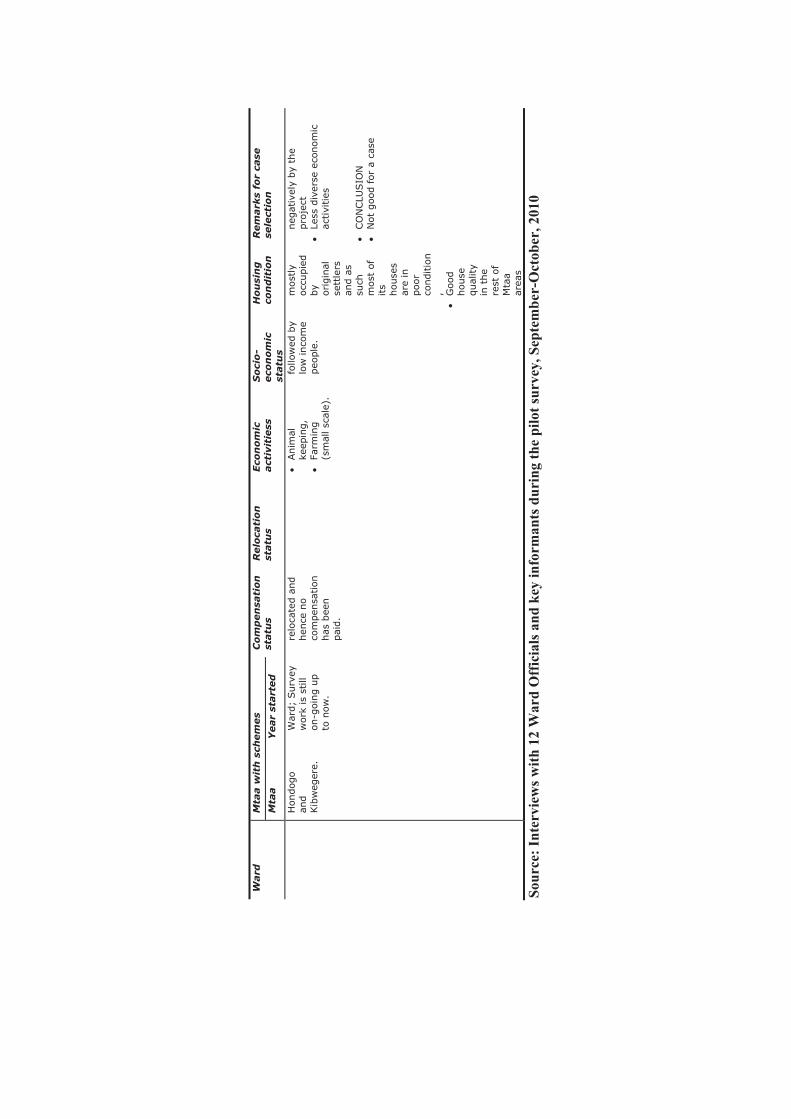
Ward
M
taa w
ith
sch
em
es
Co
mp
en
sati
on
statu
s R
elo
cati
on
statu
s Eco
no
mic
act
ivit
iess
S
oci
o-
eco
no
mic
statu
s
Ho
usi
ng
con
dit
ion
R
em
ark
s fo
r ca
sese
lect
ion
M
taa
Year
start
ed
Hondog
o
and
Kib
weg
ere.
War
d;
Surv
ey
work
is
still
on-g
oing u
p
to n
ow
.
relo
cate
d a
nd
hen
ce n
o
com
pen
sation
has
bee
n
pai
d.
�Anim
al
keep
ing,
�Fa
rmin
g
(sm
all sc
ale)
.
follo
wed
by
low
inco
me
peo
ple
.
most
ly
occ
upie
d
by
origin
al
sett
lers
an
d a
s su
ch
most
of
its
house
s ar
e in
poor
conditio
n,
�G
ood
house
qual
ity
in t
he
rest
of
Mta
a ar
eas
neg
ativ
ely
by
the
pro
ject
�
Less
div
erse
eco
nom
ic
activi
ties
�
CO
NCLU
SIO
N
�N
ot
goo
d for
a ca
se
Sour
ce: I
nter
view
s with
12
War
d O
ffic
ials
and
key
info
rman
ts d
urin
g th
e pi
lot s
urve
y, S
epte
mbe
r-O
ctob
er, 2
010

Annex
4: Fill
ed
Com
pensation S
ched
ule
Form
(H
ati y
a F
idia
iliy
oja
zwa)

