land at stakehill
TRANSCRIPT

Land at Stakehill, Rochdale
Preliminary Ecological Appraisal Report
October 2020
Collingtonwinter environmental

2 Collington Winter Environmental Ltd Ltd
Land at Stakehill
Report Control Sheet
Project Name: Land at Stakehill,
Rochdale Project Reference: CW20-013
Report Title: Preliminary Ecological Appraisal Report
Report Reference: CW20-013-RPT-001
Printing Instructions: Print at A4 Portrait, Double Sided.
Rev
Date
Descripti
on
Prepared
Reviewed
Approved
/ 21/07/2020 Draft report sent to Client for comment. OC JW OC
V1 01/10/2020 Amended with comments from client. OC OC OC
Collington Winter Environmental Ltd disclaims any responsibility to Russell Homes Ltd and others in respect of any matters outside the scope of this report. This report has been prepared with reasonable skill, care and diligence within the terms of the Contract with Russell Homes Ltd and according to the proposed plans supplied by the client or the client’s agent upon commencement of the project.
The contents of this report are valid at the time of writing. As the ecological value of a site is constantly evolving and changing, if more than twelve months have elapsed since the date of this report, further advice must be taken before reliance upon on the contents. Notwithstanding any provision of the Collington Winter Environmental Ltd Terms & Conditions, Collington Winter Environmental Ltd shall not be liable for any losses (howsoever incurred) arising as a result of reliance by the client or any third party on this report more than twelve months after the report date.
This report is confidential to Russell Homes Ltd and Collington Winter Environmental Ltd accepts no responsibility of whatsoever nature to third parties to whom this report or any part thereof is made known. Any such party relies upon the report at their own risk.
© Collington Winter Environmental Ltd 2020

0: CONTENTS
3 Collington Winter Environmental Ltd Land at Stakehill
CONTENTS
1 INTRODUCTION ...................................................................................................................................................................... 6
1.0 SCOPE & PURPOSE ..................................................................................................................................................................... 6 1.2. LOCATION .................................................................................................................................................................................. 6 1.3. OBJECTIVES ................................................................................................................................................................................ 6 1.4. PROPOSED DEVELOPMENT ........................................................................................................................................................ 7
2 METHODOLOGY ..................................................................................................................................................................... 8
2.1. DESK STUDY ............................................................................................................................................................................... 8 2.2. VEGETATION AND HABITAT ASSESSMENT ................................................................................................................................. 8 2.3. PROTECTED AND NOTABLE SPECIES ASSESSMENT .................................................................................................................... 8 2.4. SURVEY LIMITATIONS ................................................................................................................................................................ 9
3 SURVEY RESULTS ................................................................................................................................................................... 10
3.1. SITE CONTEXT .......................................................................................................................................................................... 10 3.2. DESIGNATED SITES ................................................................................................................................................................... 10 3.3. HABITATS .................................................................................................................................................................................... 11
HARDSTANDING ............................................................................................................................................................................... 11 IMPROVED GRASSLAND ................................................................................................................................................................... 11 SEMI IMPROVED GRASSLAND .......................................................................................................................................................... 12 WATERBODIES .................................................................................................................................................................................. 13 WATER COURSES .............................................................................................................................................................................. 17 HEDGEROWS .................................................................................................................................................................................... 18 TREELINES ......................................................................................................................................................................................... 19 OTHER BOUNDARY FEATURES .......................................................................................................................................................... 21 WOODLAND ...................................................................................................................................................................................... 22
3.4. SPECIES .................................................................................................................................................................................... 23 AMPHIBIANS ..................................................................................................................................................................................... 23 BIRDS ................................................................................................................................................................................................ 24 BATS ................................................................................................................................................................................................. 25 BADGER ............................................................................................................................................................................................ 25 REPTILES ........................................................................................................................................................................................... 26 WATER VOLE AND OTTER ................................................................................................................................................................. 26 WHITE CLAWED CRAYFISH ............................................................................................................................................................... 27 OTHER SPECIES ................................................................................................................................................................................. 27
4 RECOMMENDATIONS AND MITIGATION ................................................................................................................................ 28
4.1. HABITATS ................................................................................................................................................................................. 28 HEDGEROWS .................................................................................................................................................................................... 28 WATERBODIES AND WATERCOURSES .............................................................................................................................................. 28
4.2. SPECIES .................................................................................................................................................................................... 30 4.3. AMPHIBIANS ............................................................................................................................................................................ 30 4.4. BIRDS ....................................................................................................................................................................................... 30 4.5. BADGER ................................................................................................................................................................................... 31 4.6. BATS ......................................................................................................................................................................................... 31 4.7. WATER VOLE AND OTTER ......................................................................................................................................................... 34 4.8. WHITE CLAWED CRAYFISH ....................................................................................................................................................... 34 4.9. OTHER SPECIES ........................................................................................................................................................................ 35
5 SUMMARY ............................................................................................................................................................................ 36
5.1. WILDLIFE ENHANCEMENTS ...................................................................................................................................................... 36 5.2. CONCLUSION ........................................................................................................................................................................... 36
6 BIBLIOGRAPHY ...................................................................................................................................................................... 37
APPENDIX – FURTHER SURVEYS ..................................................................................................................................................... 40

6 Collington Winter Environmental Ltd Land at Stakehill
1: INTRODUCTION
1 INTRODUCTION
1.0 SCOPE & PURPOSE
1.1.1. Collington Winter Environmental Ltd was commissioned by Russells LDP to undertake a Preliminary Ecological Appraisal (PEA) at Land at Stakehill, Rochdale. This report has been prepared to support the promotion of the land for allocation.
1.1.2. The author of this report is Olivia Collington BSc (Hons), ACIEEM, MIEnvSc, CEnv, Director and Principal Ecologist at Collington Winter Environmental Ltd. Olivia is highly experienced managing schemes and has produced many ecological reports to support planning promotions.
1.2. LOCATION
1.2.1. Please refer to Figure 1.1 for the site location. The site is located to the northeast of Middleton, and to the south west of Rochdale. The A627(M) bounds the site to the east, and Stakeill Industrial Estate is located adjacent north of the site.
Figure 1.1 Site Location
1.3. OBJECTIVES
1.3.1. The objectives of the Preliminary Ecological Appraisal are as follows:

7 Collington Winter Environmental Ltd Land at Stakehill
1: INTRODUCTION
• Identify the major habitats present
• Ascertain the presence or potential presence of any legally protected or notable species
• Identify any mitigation required and opportunities for strategic wildlife enhancements 1.4. PROPOSED DEVELOPMENT
1.4.1. The proposed development includes the construction of a new commercial development comprising a series of bespoke commercial units. Associated access roads and car parking provisions are also proposed.
1.4.2. Soft landscaping is proposed, particularly to the perimeter of the site which will act as a buffer between the proposed development and adjacent habitats. Waterbodies throughout the development will be provided though they are not yet fully defined. Some of these will be used as part of the drainage solution, though they can still be effectively enhanced for wildlife.

8 Collington Winter Environmental Ltd Land at Stakehill
2: METHODOLOGY
2 METHODOLOGY
2.1. DESK STUDY
2.1.1. An initial desk-based assessment of the site was undertaken to collate baseline data. The desk study included:
• Obtaining local wildlife records from Greater Manchester Ecology Unity (GMEU) for species located within 2 km of the site.
• Review of Magic Map (https://magic.defra.gov.uk/MagicMap.aspx) website for details of any designated sites, notable habitats and presence of European Protected Species Licences.
• Review of aerial and OS maps for habitat information, as well as determining locations of potential waterbodies to be considered in the assessment.
• Review of potential habitat links on and off site, to determine the potential zone of influence of the proposed development.
2.2. VEGETATION AND HABITAT ASSESSMENT
2.2.1. An Ecological Appraisal of the site was undertaken by Olivia Collington BSc (Hons), ACIEEM, MIEnvSc, CEnv, Director and Principal Ecologist at Collington Winter Environmental. The survey was undertaken on 8th July 2020. Weather conditions were overcast though dry,
2.2.2. The walkover survey was undertaken broadly in line with standard methodology as detailed in “JNCC Handbook for Phase 1 Habitat Survey” (2010). The assessment follows methodology as per “Preliminary Ecological Appraisal” (CIEEM, 2018).
2.2.3. A Phase 1 Habitat Plan has been produced and is presented in the Appendix of this report. The mapping is based on the “JNCC Handbook for Phase 1 Habitat Survey” (2010), though adjustments have been made based on judgement to demonstrate habitats in a clearer manner, or where standard guidance does not fit the conditions found on site.
2.3. PROTECTED AND NOTABLE SPECIES ASSESSMENT
2.3.1. A search for signs of protected and notable species of fauna was undertaken during the site walkover. This included both field signs of species, as well as potential for species to be present based on habitat availability.
2.3.2. The searches broadly included the following:
• Assessment of waterbodies and terrestrial habitats for suitability to support notable amphibians.
• Searches for field signs of, and habitat suitability for bats.
• Suitability of habitats to support reptiles, and searches for incidental field signs.
• Searches for field signs of badger, including setts, mammal paths, snuffle holes, badger hair and latrines to indicate activity.
• Searches of watercourses for signs of water vole and otter, and assessment of habitat availability for the species.
• Assessment of the suitability of the site to support notable bird species and recording any field sightings of birds during the walkover.
• Assessment of the sites ability to support notable invertebrates.

9 Collington Winter Environmental Ltd Land at Stakehill
2: METHODOLOGY
• Searches for non-native invasive species.
2.4. SURVEY LIMITATIONS
2.4.1. This survey does not constitute a full botanical survey. Key species for each habitat type have been identified to give a broad representation of habitats present within the site. Further survey will be undertaken as the site progresses beyond the allocation and development plan process.
2.4.2. Full access to the site was not available and as such some areas were surveyed from roads and other PROW. Whilst confidence is given in broad habitat types and value of habitats, some species or features could have been missed due to this form of assessment. In particular, access was not available at the buildings labelled on OS maps as “Casa De Emilia” or the surrounding areas. The area where no access could be gained and the area could not be viewed from a distance is indicated on the Phase 1 Plan (20-013-001)
2.4.3. In addition, many fields were stocked with cows or horses, and as such the surveyor did not enter these fields as per Collington Winter Environmental Risk Assessment.

10 Collington Winter Environmental Ltd Land at Stakehill
3: SURVEY RESULTS
3 SURVEY RESULTS
3.1. SITE CONTEXT
3.1.1. The site is located at the edge of a residential area, with existing large-scale industrial units of Stakehill Industrial adjacent to the north. The site represents a large area of green space within the built-up area and is mainly used for agricultural purposes.
3.1.2. To the east of the site, the A627(M) is present and further agricultural land is present further north and east. The motorway, which is largely tree lined, creates a linear commuting route for a range of wildlife including bats and birds through the local landscape.
3.1.3. Habitats of high importance within the locality include Tandle Hill Country Park, which is located approximately 750 m north east of the site boundary and is comprised of woodland and grassland habitats. Manchester Gold Club is located to the North West of the site and comprises grassland and woodland habitats which are also anticipated to be highly valuable for wildlife within the local area.
3.1.4. The Rochdale Canal SSSI and SAC extends to the south of the site and is anticipated to be used as a key commuting feature for a range of wildlife.
3.1.5. Chadderton Hall Park, along with the River Irk, are located along the south western boundary of the site, and comprise, woodland, grassland and riparian habitats. The habitats in this park are managed and well used by the public.
3.1.6. The habitats on site comprise typical agricultural fields, intersected by hedgerows. These habitats can be found throughout the local area and Greater Manchester.
3.2. DESIGNATED SITES
3.2.1. The site is located, in some areas, adjacent to the Rochdale Canal Site of Special Scientific Interest (SSSI) and Special Area of Conservation (SAC). The canal runs north to south along the western boundary of the site. At the south western corner of the site, the canal is directly adjacent to the site, though further north the train line and fields separate the site from the SSSI. The site is located within the Impact Risk Zone for the SSSI.
3.2.2. The SSSI is designated for containing important habitats for submerged aquatic plans and emergent vegetation, which includes extensive colonies of “the nationally scarce SAC species floating water plantain (Luronium natans).”
3.2.3. Hopwood Woodlands Local Nature Reserve (LNR) is located approximately 1 km north west of the site boundary and are associated with the Hopwood Hall Estate, located adjacent to Manchester Golf Club.
3.2.4. A number of Sites of Biological Importance (SBI) were located within the 2 km search area. The closes to the site was Rochdale Canal Lock at Sowcroft Farm to Stott’s Lane SBI, which was located adjacent to the south west of the site boundary.

11 Collington Winter Environmental Ltd Land at Stakehill
3: SURVEY RESULTS
3.2.5. Other SBI’s present within 2 km of the site included:
• River Irk Marsh.
• Scowcroft Reservoir.
• Higher Barshaw Clough.
• Hopwood Clough.
• Lords Wood.
• A627M by Tandle Hill.
• Gerrard Wood.
• Tandle Hill Country Park.
3.3. Habitats
3.3.1. The habitats present within the site were found to be broadly typical agricultural habitats. The majority of the site was found to comprise agricultural fields, separated by species poor hedgerows. Please refer to the sections below, the Phase 1 Habitat Plan (located at the end of this report) and photographs of the site.
HARDSTANDING
3.3.2. Areas of hardstanding within the site were limited to access roads and areas around farm buildings.
IMPROVED GRASSLAND
3.3.3. The majority of the site was found to comprise improved grassland fields which were, at the time of survey, in use for livestock grazing. All were found to have a short sward height, making species identification difficult.
3.3.4. Field parcels to the north west of the site were found to comprise longer grassland, which was being used for silage growth. It is understood the grass was about to be cut at the time of survey.

12 Collington Winter Environmental Ltd Land at Stakehill
3: SURVEY RESULTS
Figure 3.1 Example of Improved Grassland throughout the site
SEMI IMPROVED GRASSLAND
3.3.5. Some fields were found to contain semi improved grassland habitats, and these were typically fields which were not in use. Semi improved habitats typically comprised species such as broad-leaved dock ( Rumex obtusifolius), rosebay willowherb (Chamaenerion angustifolium), creeping thistle (Cirsium arvense), common nettle (Urtica dioica), perennial rye grass (Lolium perenne), cocks foot (Dactylis glomerate) with occasional hawthorn (Crataegus monogyna) trees and saplings.
3.3.6. An area of marshy grassland was also present in the south eastern corner of the site, where the field was dominated by hard rush (Juncus inflexus), with rosebay willowherb and willow with occasional ash (Fraxinus excelsior) saplings. This field parcel sloped downwards towards a wet ditch.
Figure 3.2 Example of Marshy Grassland to the east of the site

13 Collington Winter Environmental Ltd Land at Stakehill
3: SURVEY RESULTS
WATERBODIES
3.3.7. A total of fifteen waterbodies were located within or directly adjacent to the site. Please refer to Table 3.1 for details of the waterbodies and photographs
WATERBODY DESCRIPTION PHOTOGRAPH
WB1 Large waterbody located approximately 200 m north west of the site. No direct access but appeared to contain emergent plants and green algae. Waterfowl present.
WB2 Immediately adjacent to WB1 and of similar composition but larger.
No photo available.
WB3 Located to the east of WB1 and WB2 in adjacent field. Large waterbody with mallard present. No direct access.
WB4 Located approximately 80 m north west of the site boundary, adjacent to WB3. Small waterbody shaded by willow (Salix sp,) and hawthorn trees. No direct access.
No photo available.
14 Collington Winter Environmental Ltd Land at Stakehill
3: SURVEY RESULTS
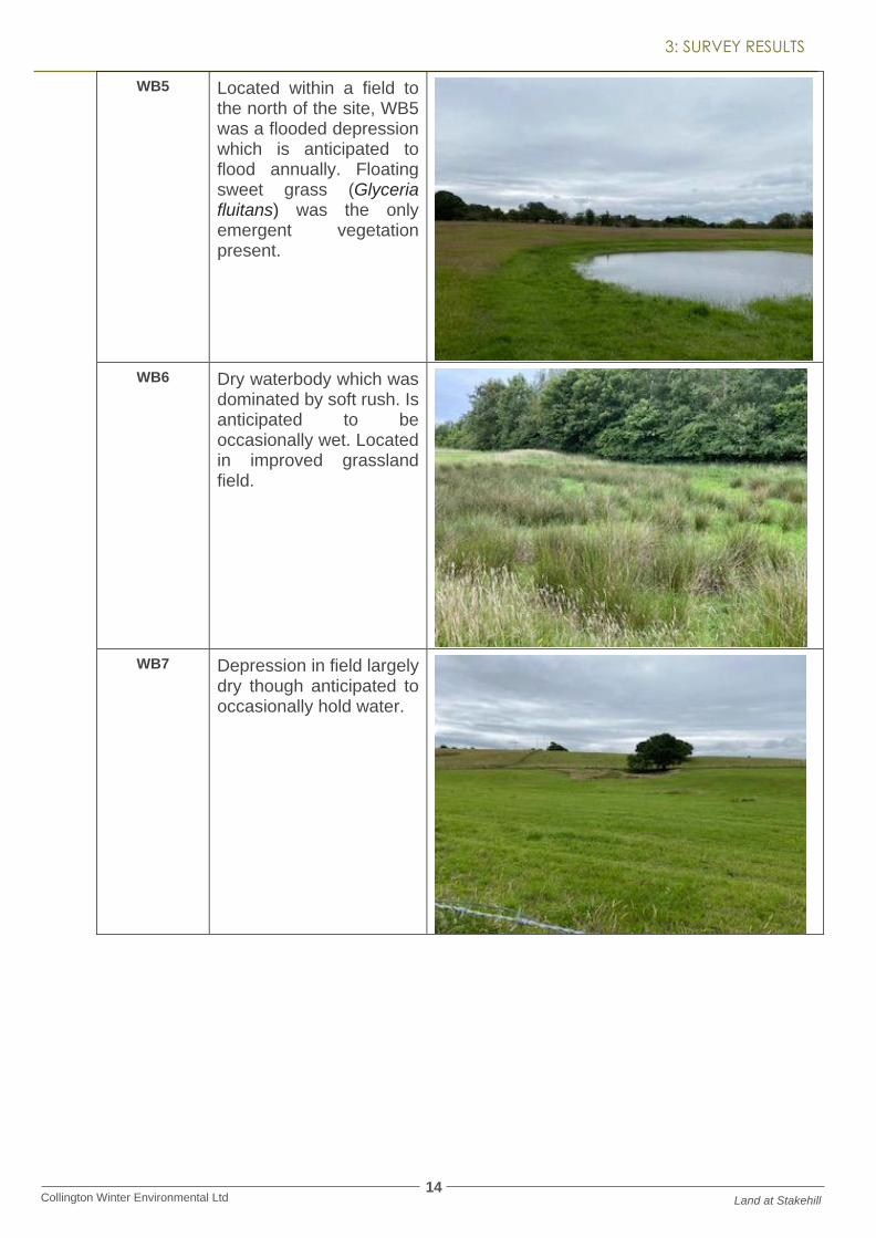
WB5 Located within a field to the north of the site, WB5 was a flooded depression which is anticipated to flood annually. Floating sweet grass (Glyceria fluitans) was the only emergent vegetation present.
WB6 Dry waterbody which was dominated by soft rush. Is anticipated to be occasionally wet. Located in improved grassland field.
WB7 Depression in field largely dry though anticipated to occasionally hold water.

15 Collington Winter Environmental Ltd Land at Stakehill
3: SURVEY RESULTS
WB8 Large waterbody within improved grassland field, used by cows. No emergent vegetation visible. Small stands of rush were present on the banks. Permanent waterbody.
WB9 No access to this field, unknow if waterbody remains present. The feature is visible on aerial mapping.
No photo available.
WB10 Unknown waterbody located in “Black Pits”. No access to this area.
No photo available.
WB11 Waterlogged feature within improved grassland field. Being used by mallards (Anas platyrhynchos) at the time of survey. Broad leaved dock and grasses were present in the water, indicating it is not a permanent feature.
16 Collington Winter Environmental Ltd Land at Stakehill
3: SURVEY RESULTS
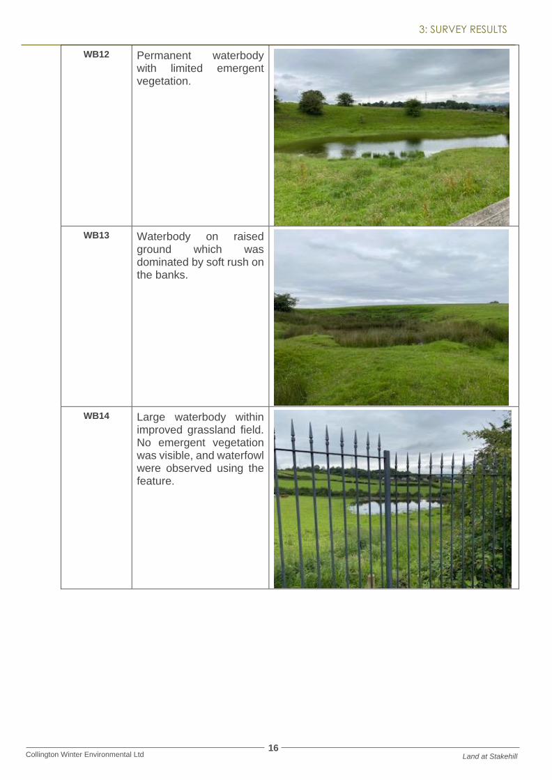
WB12 Permanent waterbody with limited emergent vegetation.
WB13 Waterbody on raised ground which was dominated by soft rush on the banks.
WB14 Large waterbody within improved grassland field. No emergent vegetation was visible, and waterfowl were observed using the feature.

17 Collington Winter Environmental Ltd Land at Stakehill
3: SURVEY RESULTS
WB15 Small wet depression within an improved grassland field. No emergent marginal vegetation was observed. No direct access was available.
WATER COURSES
3.3.8. An intermittently wet ditch runs across the site from east to west, eventually adjoining the Rochdale Canal. The stream could not be accessed in its entirety, though is known to hold some water at the eastern and western extremes.
3.3.9. At the western extreme near the canal, the stream was present in a wooded channel and heavily shaded by hawthorn trees on a steep bank. Anthropogenic debris was present within the stream at this location including an oil keg. No emergent marginal vegetation could be observed at this location.
3.3.10. At the eastern extreme, the stream became a wet ditch which traversed through marshy grassland. Here it was dominated by grasses with occasional hawthorn. Very little water was observed.
3.3.11. The Rochdale Canal SSSI and SAC is located to the adjacent west of the site and extends along much of the western and south western site boundary. The canal is well used by boats and pedestrians/ cyclists and is maintained by the Canal and Rivers Trust. The canal in this location was found to be between 8- 10 m in width with less vegetation to the north than to the south. A series of locks were in place. For much of the extent of the canal the banks were found to be comprised of either concrete or brick with limited marginal vegetation. The vegetation present was largely comprised of greater reedmace (Typha latifolia).
3.3.12. The River Irk is present to the south west of the site boundary. The river is separated from the site by a steep woodland bank which forms part of Chadderton Hall Park. The river was found to be well used by the public in this location and heavily colonised by Himalayan balsam (Impatiens glandulifera).

18 Collington Winter Environmental Ltd Land at Stakehill
3: SURVEY RESULTS
Figure 3.3 The Rochdale Canal SSSI and SAC
Figure 3.4 The River Irk within Chadderton Hall Park adjacent to the south of the site
HEDGEROWS
3.3.13. Many hedgerows were located within the site boundary, all of which were found to comprise species poor native hedgerows comprised predominantly of hawthorn with an understorey of common nettle and rosebay willowherb. Hedgerows, particularly those associated with the southern half of the site, typically also contained Himalayan balsam.

19 Collington Winter Environmental Ltd Land at Stakehill
3: SURVEY RESULTS
3.3.14. Please refer to the Phase 1 Habitat Plan for locations of the hedgerows.
Figure 3.5 Example Species Poor Hedgerow on site.
TREELINES
3.3.15. Many of the access roads across the site were bordered by treelines. Please refer to Table 3.2 for details of the treelines on site.
TREELINE REFERENCE
DESCRIPTION PHOTOGRAPH
TL1 and TL2 TL1 and TL2 border a dirt access track to the south west of the site. The trees were found to be mature and semi mature and with limited management. Species present included sycamore (Acer pseudoplatanus), hawthorn and holly (Ilex aquifolium) with Himalayan balsam and bramble (Rubus fruticosus) understory.

20 Collington Winter Environmental Ltd Land at Stakehill
3: SURVEY RESULTS
TL 3 and TL4 Extending towards the south of the site, these treelines were much the same as TL1 and TL2, with the addition of ash saplings in the understory. Some trees were found to have bat roosting potential.
TL5 and TL6 Located on the access road to Lower Acres Farm, these treelines bordered the track. The species present included ash, hawthorn and sycamore which was more managed than previous treelines. Common nettle and hogweed (Heracleum sphondylium) were present in the understorey as well as grasses.
TL7 TL7 was a young ash treeline located on the northern side of the access track. The trees were immature.

21 Collington Winter Environmental Ltd Land at Stakehill
3: SURVEY RESULTS
TL8 Treeline alongside Acres Farm, comprised of willow, conifer, cherry (Prunus sp.) and hawthorn. A wet ditch was located within the treeline which was dominated by bramble and Himalayan balsam.
TL9 Short gappy hawthorn tree line along road.
TL10 and TL11
Treeline bordering the track which runs along the northern boundary of the site, separating the site from Stakehill Industrial Estate. The treeline was dominated by hawthorn with elder, holly, beech and oak also present. The treeline was mature and well established. Himalayan balsam, common nettle, bramble and rosebay willowherb were all present in the understorey.
OTHER BOUNDARY FEATURES
3.3.16. Many of the improved grassland fields used for livestock grazing were separated by pole and
22 Collington Winter Environmental Ltd Land at Stakehill
3: SURVEY RESULTS
wire fences.
3.3.17. A railway line borders the site and demarcates the western boundary of the site. The railway line is located on a small raised bank which is colonised by tall ruderal vegetation which included broad leaved dock and willowherb.
WOODLAND
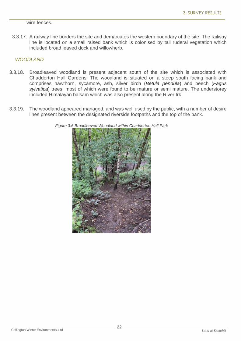
3.3.18. Broadleaved woodland is present adjacent south of the site which is associated with Chadderton Hall Gardens. The woodland is situated on a steep south facing bank and comprises hawthorn, sycamore, ash, silver birch (Betula pendula) and beech (Fagus sylvatica) trees, most of which were found to be mature or semi mature. The understorey included Himalayan balsam which was also present along the River Irk.
3.3.19. The woodland appeared managed, and was well used by the public, with a number of desire lines present between the designated riverside footpaths and the top of the bank.
Figure 3.6 Broadleaved Woodland within Chadderton Hall Park

23 Collington Winter Environmental Ltd Land at Stakehill
3: SURVEY RESULTS
3.4. SPECIES
AMPHIBIANS
3.4.1. Several waterbodies are located within, and immediately adjacent to the site. Consultation with GMEU revealed no positive records of great crested newts within the 2 km search area, however several records of great crested newt absence were present to the east of the A627 (M). The absence records will have been submitted on Natural England Licence return forms, where great crested newt surveys were undertaken though none were present.
3.4.2. Consultation with Magic Map (accessed 16th July 2020) revealed only one great crested newt (Triturus cristatus) Natural England License located within the local area. The licence appears to be associated with Junction 19 of the M62 and is located approximately 3 km north of the site. The licence was valid until 2017.
3.4.3. The waterbodies present on site mean that the site has the potential to support great crested newts in their breeding phase. Habitat Suitability Index (Oldham, 2001) has been used on each waterbody that was accessed to give an indication of their suitability to support great crested newts. Please refer to Table 3.3. for results of the HSI assessment.
Table 3.1 Habitat Suitability Assessment
HSI SCORE COMMENTS
WB1 0.54 Below Average
WB2 0.56 Below Average
WB3 0.51 Below Average
WB4 0.57 Below Average
WB5 0.54 Below Average
WB6 0.62 Average Note waterbody was dry at the time of survey so HIS assessment undertaken using best estimate of waterbody features when it holds water.
WB7 N/A Not accessible to undertake assessment
WB8 0.63 Average
WB9 N/A Not accessible to undertake assessment
WB10 N/A Not accessible to undertake assessment
WB11 0.49 Poor
WB12 0.69 Average
WB13 0.79 Good Full access couldn’t be gained to the waterbody so surveyed from a distance at fence line. Therefore, assumptions made as to water quality.
WB14 0.62 Average Full access not available so waterbody viewed from the PROW. Assumptions made on water quality and macrophyte cover.
WB15 0.41 Poor Full access not available so viewed from PROW. Assumptions made on water quality and macrophyte cover.

24 Collington Winter Environmental Ltd Land at Stakehill
3: SURVEY RESULTS
3.4.4. The Habitat Suitability Assessment reveals that several of the waterbodies have the potential to support great crested newts in their breeding phase. It is also anticipated that many of the waterbodies will be able to support common amphibians such as common frog and common toad.
3.4.5. Terrestrial habitats throughout much of the site are of low quality for great crested newts, being of improved grassland which lacks the structure to provide cover and resting places for the species. However, the hedgerows and some areas of tall ruderal could provide limited terrestrial opportunities for the species.
3.4.6. The site is linked to the wider landscape via the railway line, canal and motorway features. However, great crested newts typically only travel 250 m from their breeding ponds.
3.4.7. The presence of great crested newts on site can not be discounted at this stage. However, further great crested newt surveys will be undertaken to provide further clarity at an application stage. It is considered that if the species are present on site, suitable mitigation can be provided through any future development proposals.
BIRDS
3.4.8. Consultation with GMEU provided records of a number of Section 41 species located within the 2 km search area which included bullfinch (Pyrrhula pyrrhula), curlew (Numenius arquata), dunnock (Prunella modularis), grasshopper warbler (Locustella naevia), grey partridge (Perdix perdix), house sparrow (Passer domesticus), lapwing (Vanellus vanellus), lesser redpoll (Acanthis cabaret), linnet (Linaria cannabina), reed bunting (Emberiza schoeniclus), skylark ( Alauda arvensis), song thrush (Turdus philomelos), starling (Sturnus vulgaris) and willow tit (Poecile montanus). Other notable species recorded on the data search included kingfisher (Alcedo atthis), little ringed plover (Charadrius dubius) and peregrine falcon (Falco peregrinus).
3.4.9. Barn owl (Tyto alba) were noted within the data search, with several records located within farm buildings at Healds Green, as well as buildings to the north of the site boundary along Stakehill Lane. The site was found to provide suitable foraging opportunities for barn owl, and some of the farm buildings could have roosting value. Further surveys for barn owl will be undertaken as the application progresses and any mitigation required could be included within development proposals.
3.4.10. The habitats on site are anticipated to provide suitable habitats for farmland birds and passerine species. In addition, some of the field parcels (in particular those being left for silage) were observed to have skylark present and it is unknown if they were nesting in the vicinity.
3.4.11. The canal, river and stream could all also provide value for kingfisher.
3.4.12. The site provides suitable habitats for passerine species, through the hedgerows and treelines.
3.4.13. Opportunities for waterfowl were also present within the waterbodies, with mallard ducks and Canada geese observed on site.

25 Collington Winter Environmental Ltd Land at Stakehill
3: SURVEY RESULTS
BATS
3.4.14. Consultation with GMEU provided numerous bat records within the 2 km search area. Many of the records were associated with surrounding residential areas. Numerous records were also present within Hopwood Woods to the north east of the site.
3.4.15. The closest record of a bat roost was located adjacent to the south east of the site boundary within buildings at Healds Green. This was a common pipistrelle (Pipistrellus pipistrellus) roost.
3.4.16. Other records included myotis sp, noctule (Nyctalus noctule), soprano pipistrelle (Pipistrellus pygmaeus) brown long eared (Plecotus auratus), daubenton’s (Myotis daubentoniid) and natterer’s bats (Myotis nattereri).
3.4.17. The site contains several features which could provide roosting opportunities for bats. The buildings on site were not fully surveyed due to access, however several of the buildings were of a condition which would support bat roosting potential. Further survey is required to determine if bats are present.
3.4.18. Trees within TL1 – TL6, TL8 and TL9 contained trees which were mature and provide bat roosting potential, and the treelines are expected to be used by commuting and foraging bats within the local area. The hedgerows on site, though species poor, are anticipated to also provide commuting habitats for bats.
3.4.19. Other significant commuting features for bats within the site comprise the railway line. Though this feature is relatively unvegetated, it does create a significant linear feature running north to south through the site, and it is expected bats will utilise this. The motorway to the east of the site is treelined and expected to facilitate wildlife commuting from the local area.
3.4.20. The Rochdale Canal and River Irk are expected to be valuable resources for bats within the wider landscape, acting as both linear commuting corridors, and foraging/ drinking opportunities for bats. The presence of these watercourses, as well as large waterbodies on and around site, make the presence of species such as daubenton’s more likely.
3.4.21. The site is assessed as having high value for bats as per guidance set out in Collins (2016). Further survey is recommended at the planning application stage which would determine the level of mitigation which can be provided within development proposals.
BADGER
3.4.22. GMEU provided records of badger within the 2 km search radius. Records of badger are confidential and are therefore not to be placed within the public domain.
3.4.23. No signs of badger (Meles meles) were identified during the updated walkover of the site. However, full access to the site was not available, and therefore some suitable habitats (such as hedgerows and field margins) could not be fully inspected for signs of badger.
3.4.24. Suitable locations for sett building and foraging were located, and badger could commute around the site. The site is well linked to the wider landscape through the canal, railway and motorway corridors, and it is anticipated the species are present locally.

26 Collington Winter Environmental Ltd Land at Stakehill
3: SURVEY RESULTS
REPTILES
3.4.25. GMEU provided records of grass snake (Natrix natrix) and slow worm (Anguis fragilis) within Tandle Hill Park, approximately 700 m north east of the site boundary, separated from the site by the A627 (M).
3.4.26. The habitats on site were found to be sub optimal for the species, with the majority of the site being comprised of improved grassland fields which lack the structure to support the species group. The hedgerows and tree lines may provide some value, however basking opportunities were found to be limited.
3.4.27. The site is well connected for the species group, via the railway, canal and river corridor. However, there is limited motivation for reptiles to commute to the site, given the limited opportunities present for the species group.
3.4.28. Given the habitats present, the species group are reasonably discounted from the assessment.
WATER VOLE AND OTTER
3.4.29. Consultation identified records of water vole (Arvicola amphibious) within the Rochdale Canal SSSI and SAC to the north west of Stakehill Industrial Estate. Other records were also present to the north of Hopwood Woods LNR.
3.4.30. The stream present within the site has unknown value for water vole. At the eastern extent, it was found to be largely dry, shallow and dominated by grasses and therefore unsuitable for water vole. At the western extreme, the stream comprised steep wooded banks, though no marginal vegetation was present. It is unknown what the habitats in the middle comprised.
3.4.31. The Rochdale Canal SSSI and SAC is located adjacent west of the site. In general, the canal appeared sub optimal for the species, being highly used and lacking marginal vegetation particularly towards the north. As the canal extended south, it became more natural and as such some opportunities for water vole could be present. Water vole are known to utilise canals, even where banks are block or concrete and as such their presence can’t be discounted.
3.4.32. The River Irk is present to the south west of the site boundary and runs through Chadderton Hall Park. The river in this area was well used by the public and subject to anthropogenic disturbance. The banks were relatively shallow and chocked by Himalayan balsam. It was assessed that habitats on this section of the River Irk were sub optimal for the species, though detailed survey has not taken place.
3.4.33. The waterbodies on site were not found to provide optimal habitats for the species. However, a detailed inspection has not taken place and not all waterbodies were accessed.
3.4.34. No records of otter (Lutra lutra) were obtained during the data search, however this does not confirm absence of the species.

27 Collington Winter Environmental Ltd Land at Stakehill
3: SURVEY RESULTS
3.4.35. Both the River Irk and Rochdale Canal could be used by otter, and both provided suitable habitats for resting, foraging and commuting for the species. The site itself provided limited opportunities for otter, and the stream that runs through the site does not provide any suitable features for otter.
WHITE CLAWED CRAYFISH
3.4.36. Consultation identified a single record of white clawed crayfish (Austropotamobius pallipes) with the Rochdale Canal SSSI and SAC, located adjacent to Slattocks.
3.4.37. The stretch of the Rochdale Canal adjacent to the site could have value for the species, as well as The River Irk to the south which was found to comprise stony substrate which could support the species.
3.4.38. The stream which extends through the site has unknown value for white clawed crayfish as a full inspection could not be undertaken. A full assessment will be undertaken at the next stage of the planning process to inform any mitigation required which can be accommodated within development proposals.
OTHER SPECIES
3.4.39. The site could support European hedgehog (Erinaceus europaeus) and it is anticipated the species will be present within the local area due to the residential nature of habitats to the south. The treelines and hedgerows would in particular be of value for the species.
3.4.40. Brown hare (Lepus europaeus) typically require open grassland fields with some areas of longer grassland. The site is considered broadly suitable for brown hare, though none were observed during the survey. No records of brown hare were identified during consultation with GMEU.
3.4.41. The site was found to support low numbers of common butterfly during the site survey, and it is anticipated it will support common and widespread invertebrate species based on the habitats present. The waterbodies could support notable species.
3.4.42. No notable species of flora were located during the site survey and based on the habitats present their presence would be unlikely.
3.4.43. Himalayan balsam, which is listed on Schedule 9 of the Wildlife and Countryside Act 1981 was located throughout the site.

28 Collington Winter Environmental Ltd Land at Stakehill
4: RECOMMENDATIONS AND MITIGATION
4 RECOMMENDATIONS AND MITIGATION
4.1. HABITATS
4.1.1. The majority of habitats present within the site were found to be common and widespread, typifying the agricultural landscape. The improved grassland fields were found to be of general low value due to intensive grazing. The hedgerows, waterbodies and off-site woodland were found to have the highest value for wildlife.
4.1.2. Detailed landscaping proposals were unavailable at the time of writing; however, a proposed arrangement was provided. It is understood that several of the hedgerows present within the site will be removed, as well as loss of several waterbodies. The off-site woodland to the south associated with Chadderton Hall Park is to be protected via a buffer, as well as the treeline to the north of the site. A buffer is also proposed from the Rochdale Canal at the south west of the site.
4.1.3. A significant buffer around the boundary of the site is proposed, the full detail of which is to be agreed post allocation, however any buffer has the potential to support and enhance wildlife through the inclusion of appropriate landscaping.
HEDGEROWS
4.1.4. The hedgerows on site were typically found to be species poor and managed. The loss of these hedgerows could create a loss in linear commuting features for wildlife, as well as loss of nesting habitat. It is recommended that any hedgerows to be removed for development are replanted elsewhere on site (such as within landscaped areas), on the same aspect and direction to maintain commuting links. The positioning of replacement hedgerows will be determined by further protected species surveys detailed in the sections below. It is anticipated that sufficient mitigation can be included within the site to mitigate for hedgerow loss, and therefore this should not prevent the site being allocated.
4.1.5. Hedgerow replanting should comprise species rich hedgerows, with a minimum of seven species present. Ideally, trees should be planted within the hedgerows every 10-20 m to further increase the value for biodiversity. As hedgerows take time to establish, if possible, some hedgerows should be planted in soft landscaping areas at the outset of development, to allow time to develop during construction.
WATERBODIES AND WATERCOURSES
4.1.6. Waterbodies to be removed may require specific species mitigation as detailed below which would determine replacement waterbody specification and location. However, at a minimum it is expected that an equivalent number of waterbodies would need to be provided as those removed. It is anticipated that some of these waterbodies could be SUDS features which are enhanced for wildlife. Many of the waterbodies currently available on site are trampled by livestock and provide negligible emergent vegetation for wildlife to utilise. Providing new waterbodies designed for wildlife would be expected to create higher value for wildlife. Further specification on waterbody design would be provided after protected species surveys have been undertaken at the planning application stage.
4.1.7. Rochdale Canal is located adjacent to the site in the south western corner. The canal is

29 Collington Winter Environmental Ltd Land at Stakehill
4: RECOMMENDATIONS AND MITIGATION
designated in part for the presence of floating water plantain, and therefore efforts are required to ensure no negative impacts on this feature. The proposed arrangement demonstrates a buffer between development and the canal which will protect the feature from development.
4.1.8. It is recommended that at the planning application stage, a Construction Environmental Management Plan (CEMP) be produced to detail protection measures for the watercourse and outline best practice working methods. This would be expected to broadly include:
• Induction for all contractors as to working methods to protect the watercourse.
• Understanding of any potential run off from the site and methods to prevent silt or pollutants entering the watercourse.
• Pollution prevention measures including machine refuelling and storage of materials.
• Signage and fencing to demarcate the buffer area.
• Monitoring of the works and emergency protocols in case of spillage.
• Prevention of dust deposition should be considered.
4.1.9. The Rochdale Canal is a SSSI and SAC. Consultation with Magic Map identified that the site is within the Impact Risk Zone for the SSSI, and Natural England require consultation on all commercial developments of this nature within the risk zone. It is anticipated a Habitat Regulations Assessment may be required at the planning application stage, and Natural England should be consulted for a scoping opinion. However, at this stage we do not consider there to be any matters from an ecological perspective that should prevent the site from being allocated. It is anticipated that sufficient protection measures and buffers could be provided as detailed above.
4.1.10. Chadderton Hall Park is located adjacent to the southern boundary of the site, and a landscaped buffer is proposed in this area. A broadleaved woodland separates the site from the River Irk. The following protection measures should be adhered to during construction, and a CEMP should provide further detail of these measures at the planning application stage.
• Signage and fencing of the buffer area (minimum 10-15 m) to ensure no unauthorised working or storage of materials.
• The woodland is located on a steep south facing bank, it is therefore important no run off from the site is allowed to enter the woodland and run down to the river. Protection measures should be employed.
• Monitoring of the woodland and river for signs of pollution, and remedial measures if required.
• Prevention of dust deposition in the woodland and watercourse should be considered.
4.1.11. Any trees and hedges to be retained through the works will be appropriately protected through Root Protection Area Fencing.
4.1.12. Himalayan balsam was found throughout the site. This species is listed on Schedule 9 of The Wildlife and Countryside Act 1981 and therefore should be removed from the site by a qualified contractor prior to any works commencing. It is the developer’s obligation to ensure the species does not spread off site.
30 Collington Winter Environmental Ltd Land at Stakehill
4: RECOMMENDATIONS AND MITIGATION
4.2. SPECIES
4.3. AMPHIBIANS
4.3.1. The site contains a number of waterbodies that have been assessed for their suitability to support great crested newts. Further surveys will be undertaken at the planning application stage to determine presence/ absence of the species.
4.3.2. If great crested newts are found to be absent, specific mitigation may not be required. However, the waterbodies are anticipated to support common amphibians, and other notable species such as common toad, and as such the following should be followed:
• All site contractors should be inducted as to the presence of amphibians on site, and best practice methods of relocating common amphibians, as well as location of relocation.
• Any vegetation should be first strimmed to 150 mm and left overnight to allow any amphibians to disperse unharmed.
• Waterbodies to be removed should ideally be drained down in the Autumn when amphibians are not present breeding.
4.3.3. To mitigate for the loss of waterbodies within the site, it is recommended that a series of new water bodies are provided. An indicative masterplan from the Harris Partnership has been provided which supports the inclusion of waterbodies in line with ecological guidance. These will be enhanced specifically to target great crested newts and common amphibians and will broadly follow guidance set out in Froglife – Just add Water Publication (2009).
4.3.4. Terrestrial habitat should be created surrounding each new pond, including grassland and scrub. Commuting links will be created between ponds through grassland areas and woodland blocks. This will allow the species group to colonise new ponds and widen their population range.
4.3.5. The boundary buffer proposed within the site is proposed to be planted to provide terrestrial habitat for wildlife. This boundary will maintain commuting links to the wider landscape.
4.3.6. Further specific mitigation may be required if the site is found to contain great crested newts. This can be provided within the scheme, with sufficient space available to provide new habitats for great crested newts within the landscaping areas of the site. Details of further mitigation required for the species would be detailed after further surveys have been undertaken.
4.4. BIRDS
4.4.1. The site supports farmland agricultural habitats, which were found to have the potential to support ground nesting and passerine bird species. Due to the size of the site, scale of the habitats to be lost to development, and local presence of notable species, it is recommended that a breeding bird survey be undertaken to determine the species of bird present and how they utilise the site. This will inform any specific mitigation required.
4.4.2. Breeding bird surveys will be undertaken at the relevant stage in the planning application between April – June.

31 Collington Winter Environmental Ltd Land at Stakehill
4: RECOMMENDATIONS AND MITIGATION
4.4.3. The surveys comprise a walked transect through the site, listening to bird song and observing any bird territorial behaviour. The results of this survey would determine specific mitigation required.
4.4.4. In general, mitigation for birds within the site will comprise the provision of new habitats suitable for nesting, foraging and commuting and these will be located within the proposed soft landscaping areas. It is recommended that replacement hedgerow, tree and grassland be provided as well as bird boxes throughout the development.
4.4.5. New waterbodies are to be proposed within the landscaping which will provide new habitats for waterfowl such as mallard ducks and any other wetland bird species which could be present locally. New waterbody design would
4.4.6. An inspection of the buildings present within the site which are proposed for demolition should be undertaken to search for signs of barn owl. This can be undertaken in line with the inspection recommended for roosting bats. If barn owl are located, alternative habitat provision will be required.
4.4.7. During site clearance, any vegetation removal should be undertaken outside the breeding bird survey season (March – September inclusive). If this is unavoidable, a suitably qualified ecologist will first undertake a nesting bird check prior to clearance. If any nests, or nests in construction are located, works must cease immediately, and a suitable buffer set out around the nest. The buffer should be appropriately fenced and signed to avoid works in the area. This must be retained until the young have fledged. Nesting bird checks are valid for 24 hours, and as such any vegetation should be cleared immediately after the area has been cleared by the ecologist.
4.5. BADGER
4.5.1. No evidence of badger was found within the site; however, the local area was assessed as having suitability for the species and therefore a precautionary approach will be undertaken.
4.5.2. Post development, soft landscaping of the site should be designed to create habitats for badger, with hedgerows, grassland, scrub and fruiting trees. Linear commuting routes designed for other wildlife would also benefit badger, and it is anticipated the boundary landscape features of the site will be of benefit for the species.
4.5.3. Sensitive lighting should be deployed at the boundary features.
4.6. BATS
4.6.1. The site is assessed as providing high value for foraging and commuting bats, mainly based on the linear habitat features on and adjacent to the site. Development proposals indicate the removal of a number of hedgerows, waterbodies and stream through the centre of the site.
4.6.2. In line with guidance set out in Collins (2016), bat activity surveys be undertaken, at the appropriate stage in the planning application, within the site to determine the use of the site by bats, the species assemblage, numbers and features of highest importance. This will determine specific mitigation within the site.
32 Collington Winter Environmental Ltd Land at Stakehill
4: RECOMMENDATIONS AND MITIGATION
4.6.3. Bat activity surveys should be undertaken between May- October and comprise a walked transect around the site, paying specific attention to features which could be of high importance to bats (waterbodies, hedgerows, canal and river). Surveyors will use handheld bat detectors to record bat activity.
4.6.4. As per best practice guidance for habitats with high value for bats, it is recommended two surveys per month be undertaken on the site. However, it is proposed that a static detector be used in place of one survey per month. The static detectors will be left at features of importance for 5 consecutive nights per month and the data analysed.
4.6.5. During the walkover survey, full access was not available, and therefore the buildings on site which would be lost to development were not surveyed for bat roosting potential. Some of the buildings when observed from a distance appeared to be of an age and condition which could support roosting bats.
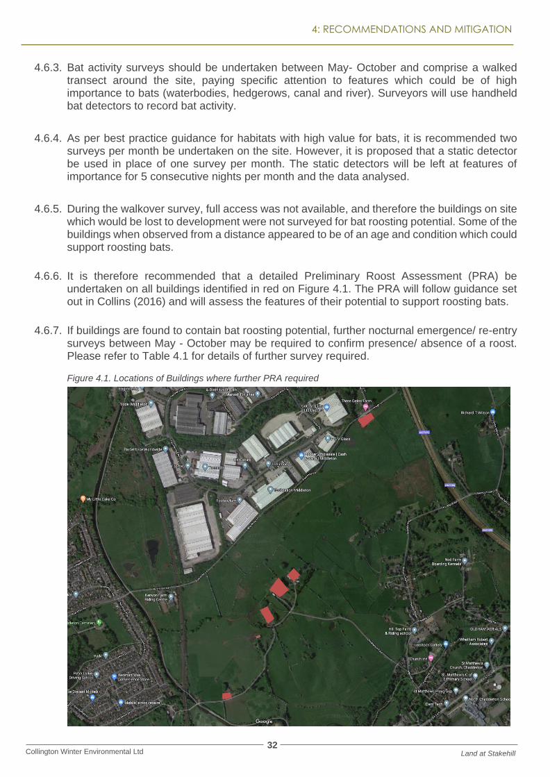
4.6.6. It is therefore recommended that a detailed Preliminary Roost Assessment (PRA) be undertaken on all buildings identified in red on Figure 4.1. The PRA will follow guidance set out in Collins (2016) and will assess the features of their potential to support roosting bats.
4.6.7. If buildings are found to contain bat roosting potential, further nocturnal emergence/ re-entry surveys between May - October may be required to confirm presence/ absence of a roost. Please refer to Table 4.1 for details of further survey required.
Figure 4.1. Locations of Buildings where further PRA required

33 Collington Winter Environmental Ltd Land at Stakehill
4: RECOMMENDATIONS AND MITIGATION
Table 4.1 Further Survey Required on Buildings
BAT ROOSTING POTENTIAL
FURTHER SURVEY REQUIRED
Negligible No further survey
Low 1 dusk/ dawn survey/ Precautionary Working Methods
Moderate 2 dusk/ dawn surveys
High 3 dusk/ dawn surveys
4.6.8. If bats are located roosting within any buildings, a Natural England Mitigation Licence would be required to allow development to proceed. This would entail specific mitigation dependent on the size, type and species of bat roosts present.
4.6.9. Trees with bat roosting potential were located within TL1 – TL6, TL8, TL10 and TL11. In addition, the woodland adjacent south of the site associated with Chadderton Hall Park was found to contain bat roosting potential.
4.6.10. Those trees within the treelines which require removal will require further survey. It is recommended this be undertaken close to the time site clearance will commence (as tree condition can change). An ecologist should undertake an updated inspection of the trees to be lost and further surveys could be required as set out in Table 4.2.
Table 4.2 Further Survey Required on Trees
BAT ROOSTING POTENTIAL
FURTHER SURVEY REQUIRED
Negligible No further survey required
Low Soft Fell tree (cut into sections (avoiding any potential roosting features, and lay on the ground overnight before chipping)
Moderate Climbed aerial inspection to determine if bats are present or 2 dusk/ dawn emergence surveys between May – October.
High Climbed aerial inspection to determine if bats are present or 3 dusk/ dawn emergence surveys.
4.6.11. As above, if roosting bats are located within a tree, a Natural England Mitigation Licence would be required to enable the tree to be felled.
4.6.12. Proposed construction lighting is to follow the protocols outlined in the Institute for Lighting Engineers document “Guidance for the Reduction of Obtrusive Lighting” (2005) and BCT’s “Bats and Artificial Lighting in the UK” (2018) to minimise disturbance and sky-glow off site.
4.6.13. No lighting during construction is to be aimed towards boundary features, offsite watercourse or railway line.
4.6.14. Lighting is to be pre-fixed to the buildings to ensure that unmitigated impacts of lighting on the surrounding areas is diminished.
▪ Warm white tones are preferable to blue toned lights (3000k)

34 Collington Winter Environmental Ltd Land at Stakehill
4: RECOMMENDATIONS AND MITIGATION
▪ LED light will be used where applicable as they produce less UV.
▪ Lights will be downward facing and positioned to avoid light spill skywards.
4.6.15. Replacement hedgerows and waterbodies should be provided to create new habitats for bats post development. Woodland blocks could be provided in addition, which when established, could create new roosting habitats for bats.
4.6.16. A series of bat boxes should be installed post development to provide immediate roosting locations for bats. If any roosting bats are located within the site during further surveys, specific mitigation may be required regarding bat boxes.
4.7. WATER VOLE AND OTTER
4.7.1. The Rochdale Canal and River Irk are located adjacent to the south west of the site. These features have the potential to support otter and water vole given the habitats present.
4.7.2. A buffer is proposed between the development and these features, however at this stage it is unclear if any impacts on the watercourses will be present. This would include the provision of outfalls into the features, any run off from the site, change in water levels or other anthropogenic disturbance.
4.7.3. It is therefore recommended, if the above impacts can’t be discounted, that a full water vole and otter survey of the Rochdale Canal and the River Irk is undertaken. This would include a walkover of the watercourses directly adjacent to the site, and approximately 500 m upstream and downstream to provide full data of any otter or water vole which could be present. The survey should be undertaken between April – September.
4.7.4. It is deemed that both watercourses are accessible by bankside, though a boat may be required if this is not found to be the case during the survey.
4.7.5. The stream which runs through the site could not be fully inspected during this survey. It is recommended that the feature be fully surveyed for potential to support otter and water vole.
4.8. WHITE CLAWED CRAYFISH
4.8.1. Records of white clawed crayfish are present within the Rochdale Canal to the north, and therefore could be present further south, or within the stream within the site.
4.8.2. If impacts are likely on the canal and River Irk, it is recommended that a white clawed crayfish survey be undertaken on the features to confirm presence or absence in these locations. It is not deemed a survey would be necessary if it can be demonstrated that no impacts on the watercourses would be present (such as pollution, change in water levels, dust deposition during construction, and no outfalls into the watercourses are proposed).
4.8.3. The stream which extends through the site requires further inspection to determine if it provides any suitable habitat for the species. It is anticipated to only hold water at the western extent and is deemed unlikely to support the water quality and habitat requirements to support the species.
35 Collington Winter Environmental Ltd Land at Stakehill
4: RECOMMENDATIONS AND MITIGATION
4.9. OTHER SPECIES
4.9.1. The site was found to have value for hedgehog, and it is possible the species are present within the treelines and hedgerows throughout the site.
4.9.2. To ensure no hedgehog are harmed during development, it is recommended that all hedgerows to be removed are first searched by hand to check for hedgehog. This method should also be used for any dense areas of vegetation. Any hedgehogs located should be carefully removed from the development area and relocated to a safe location.
4.9.3. The site was also assessed as having some value for brown hare which are a notable species. To ensure no hare are injured during development it is recommended that an ecologist conducts a walkover of any grassland fields with a longer sward height to check for young hare. If any are located works should cease in that area until the hare have relocated. Any fields being strimmed should be done so in a directional manner, allowing any mammals the chance to escape.
4.9.4. Connection to the wider landscape should be maintained within the proposed development, and it is anticipated that this can be achieved through the enhanced buffers around the boundaries of the site.

36 Collington Winter Environmental Ltd Land at Stakehill
5: SUMMARY
5 SUMMARY
5.1. WILDLIFE ENHANCEMENTS
5.1.1. The proposed development has scope for a range of enhancements to benefit wildlife. These include:
• Provision of native fruiting and flowering plants throughout the development.
• Enhanced planted buffer zones round the boundaries of the site. It is anticipated these could be comprised of grassland areas, wildlife ponds, scrub and woodland planting to create structural diversity.
• Provision of a series of wildlife ponds and enhanced SUDS features.
• Installation of bat and bird boxes throughout the site.
• Installation of hedgehog houses.
5.2. CONCLUSION
5.2.1. Based on the initial ecological walkover of the site and discussions with Russells LDP regarding mitigation and enhancements which can be included in the site design, it is not considered any ecological matters are present within the site which would prevent the site from being allocated.
5.2.2. Relevant mitigation for all species could be provided on site. Russells LDP are a considerate developer and have welcomed ecological input into potential site design.

37 Collington Winter Ltd Environmental Ltd Land at Stakehill
5: SUMMARY
6 BIBLIOGRAPHY
• Bat Conservation Trust (2018). Bats and Artificial Lighting in the UK: Bats and the Built Environment Series.
• Chartered Institute of Ecology and Environmental Management (2018). Guidelines for Preliminary Ecological Appraisal.
• CIEEM (2018). Guidelines for Ecological Impact Assessment in the UK and Ireland: Terrestrial, Freshwater, Coastal and Marine.
• Collins, J. (ed.) (2016). Bat Surveys for Professional Ecologists: Good Practice Guidelines, 3rd edition. The Bat Conservation Trust, London.
• Environment Alliance (2007). PPG5: Pollution Prevention Guidelines; Works and Maintenance In or Near Water; PPG5.
• English Nature (2001). Great Crested Newt Mitigation Guidelines.
• Froglife (2001). Great Crested Newt Conservation Handbook.
• Froglife (2009). Just Add Water: How to Build a Wildlife Pond. Sixth Edition.
• Institute of Lighting Engineers (2005). Guidance Notes for the Reduction of Obtrusive Light.
• JNCC (2010). Handbook for Phase 1 habitat survey: A technique for environmental audit. English Field Unit, Nature Conservancy Council.
• Mitchell-Jones (2004). Bat Mitigation Guidelines: Working Today for Natura Tomorrow. English Nature.
• Mitchell-Jones and McLeish (2004). Third Edition Bat Workers’ Manual.
• Oldham, R. S., Keeble J., Swan, M. J. S. & Jeffcote, M. (2000). Evaluating the suitability of habitat for the Great Crested Newt (Triturus cristatus). Herpetological Journal 10 (4), 143–155.
• Wildlife and Countryside Act (2010) Schedule 9 of the Wildlife and Countryside Act 1981

5: SUMMARY

5: SUMMARY
40 Collington Winter Ltd Environmental Ltd Land at Stakehill
5: SUMMARY
APPENDIX – FURTHER SURVEYS
7.1.1. Further Surveys for the species present or potentially present on site have been detailed above. Potential mitigation has also been outlined, though this would be confirmed by the results of further surveys.
7.1.2. This is summarised within Table 5.1 below.
Table 5.1 Further Species Surveys Required
SPECIES FURTHER SURVEY REQUIRED TIMESCALE
Amphibians Environmental DNA on all on site waterbodies and waterbodies present within 250 m of the site boundary. If eDNA results are positive, further population size assessment would be required.
15th April – 30th June Mid-March – end of June
Birds Breeding bird surveys which comprise a walked transect through the site. Five surveys are recommended. Barn owl survey of buildings to be demolished. Vegetation to be cleared outside of the breeding bird season (March – September inclusive) or a nesting bird check undertaken no more than 24 hours prior to the clearance.
April – June March - September March - September
Badger Updated Walkover prior to commencement of site clearance.
Any time of year
Bats Bat transect surveys of the site including the use of a static detector. A minimum of one survey per month is required plus the use of the static detector. Preliminary Roost Assessment (PRA) on buildings to be demolished. If buildings are found to have bat roosting potential, bat emergence surveys will be required. Trees with bat roosting potential to be felled require an updated inspection prior to clearing. A climbed inspection or further emergence surveys may be required.
May – October Any time of year May – October May - October
Otter and Water Vole
If impacts on the watercourses can’t be discounted, a full otter and water vole survey should be undertaken on the features and 500 m upstream and downstream. Survey will also be required on stream through the site.
April - September
White clawed crayfish
Inspection of stream to assess habitat suitability. Survey of River and Canal (if impacts can’t be discounted)
Any time of year. Mid July – Mid September

41 Collington Winter Ltd Environmental Ltd Land at Stakehill
5: SUMMARY
Brown Hare Walkover of grassland fields with longer grassland sward prior to clearance to check for any young hare.
Any time of year
Hedgehog Check any hedgerows, treelines or dense vegetation by hand prior to clearance.
Any time of year

Collingtonwinter environmental