land at usworth, washington - sunderland.gov.uk · people’s quality of life. ... • cm7:...
TRANSCRIPT

1
Land at Usworth, Washington Planning and Development Brief
May 2018
Contents
Introduction 1
Section One: Planning and Design Guidance 2 The Site 3 Planning Policy Context 5 Site Constraints 7 Planning and Design Principles 8
Section Two: Tender Process and Submission Requirements 14 Additional Information 15 Tender Process 18
Appendix One: Abnormal Policy 21
Appendix Two: Topography plan 25
1
Sunderland City Council is seeking to dispose of its freehold interest in 8.4 ha of surplus land at Usworth, Washington, Sunderland, Tyne and Wear. The site offers an opportunity to provide new residential development of high quality, family accommodation within the desirable location of Usworth, Washington. The currently vacant site is located approximately three miles from Washington Town Centre and 8 miles from Sunderland City Centre. The site extends to approximately 8.4 hectares.
This Planning and Urban Design Brief has been prepared to support the disposal of the Council’s land interest and to ensure development achieves the highest possible planning and urban design standards.
The brief identifi es the key planning and design issues most relevant to this site and indicates the planning and urban design considerations that will be used to assess submitted proposals.
Applicants should therefore consider the advice offered as part of this brief and clearly demonstrate through their submissions how their proposals meet these requirements.
Requirements for the comprehensive development of the site are set out in Section One of this document.
The disposal will be conducted through a two stage process, set out below.
Stage one:Developers are now invited to submit planning and design proposals for consideration in accordance with the requirements set out in this brief.
Stage two:Those developers whose submissions in the opinion of the Council are satisfactory, and in the case of redevelopment proposals comply with the requirements of the brief, will be invited to submit a fi nancial offer (see pg 20).
The successful applicant will be required to submit their proposals for pre-application stage two advice.
Introduction

2
Section One: Planning and design requirements
3
Location and DescriptionThe site is located in the north of Washington in the sought after area of Usworth and within close proximity to South Tyneside and Gateshead.
The site was previously occupied by Usworth Comprehensive School until its demolition in 2007. The school buildings were located to the south of the site with the remaining area used as school playing fi elds and athletics track. Following the closure of the school part of the site was developed to provide Sunderland College Washington Campus which lies directly to the west.
The site is located within a predominately residential area and has good access to local facilities. Washington Town Centre, with all local amenities including shopping and leisure facilities, health centre and local transport hub, lies 3 miles to the south. Sunderland City Centre is 8 miles to the south-east and Newcastle 8 miles to the north west.
The site is a brownfi eld/greenfi eld mix. A mature woodland belt is located to the west of the site which acts as a noise buffer for the A195, Mature tree planting is also located on the northern edge and surrounding the redundant athletics track.
The site is relatively fl at in nature except for two instances; in the south west the land rises from the existing area of hard standing to Essex Drive and along the western edge there is slight elevational changes between Heworth Road and the site.
The Site
view toward south west of site View to the east of site
Site location
Washington Town Centre
Concord Local Centre
Nissan
A1231
A182
A1
A194
(M)
A195
To Sunderland
To Gateshead/ South Tyneside
The site
4
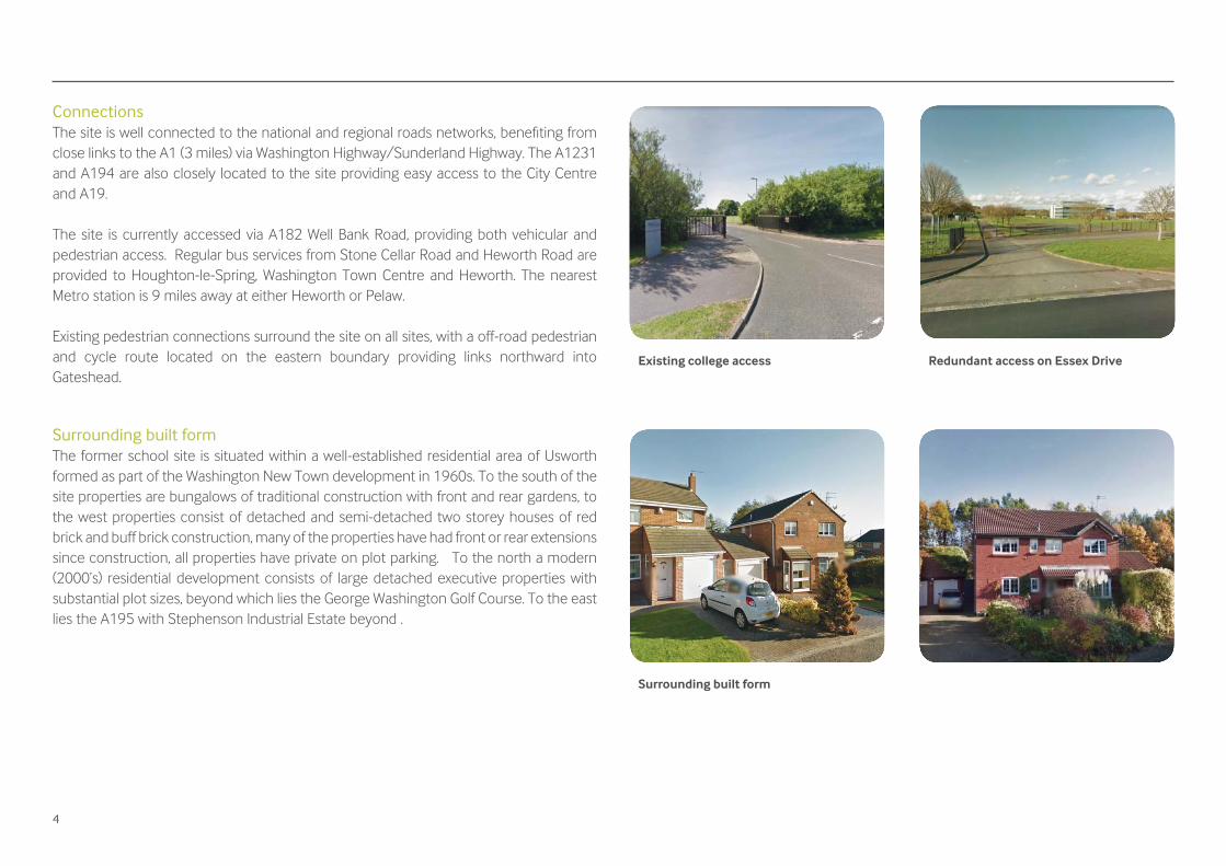
ConnectionsThe site is well connected to the national and regional roads networks, benefi ting from close links to the A1 (3 miles) via Washington Highway/Sunderland Highway. The A1231 and A194 are also closely located to the site providing easy access to the City Centre and A19.
The site is currently accessed via A182 Well Bank Road, providing both vehicular and pedestrian access. Regular bus services from Stone Cellar Road and Heworth Road are provided to Houghton-le-Spring, Washington Town Centre and Heworth. The nearest Metro station is 9 miles away at either Heworth or Pelaw.
Existing pedestrian connections surround the site on all sites, with a off-road pedestrian and cycle route located on the eastern boundary providing links northward into Gateshead.
Surrounding built formThe former school site is situated within a well-established residential area of Usworth formed as part of the Washington New Town development in 1960s. To the south of the site properties are bungalows of traditional construction with front and rear gardens, to the west properties consist of detached and semi-detached two storey houses of red brick and buff brick construction, many of the properties have had front or rear extensions since construction, all properties have private on plot parking. To the north a modern (2000’s) residential development consists of large detached executive properties with substantial plot sizes, beyond which lies the George Washington Golf Course. To the east lies the A195 with Stephenson Industrial Estate beyond .
Existing college access
Surrounding built form
Redundant access on Essex Drive
5
National Planning Policy FrameworkThe National Planning Policy Framework (NPPF) and the National Planning Policy Guidance (NPPG) set out national policy guidance in relation to key planning principles. At the heart of the NPPF is the presumption in favour of sustainable development, however, the NPPF also establishes the following principles relevant to this site and to which development proposals must adhere:
• Seek positive improvements in the quality of the built environment as well as in people’s quality of life.
• Encourage the effective use of land by reusing land that has been previously developed.
• Deliver a wide choice of high quality homes, widen opportunities for home ownership and create sustainable, inclusive and mixed communities
• Respond to local character and history, and refl ect the identity of local surroundings and materials, whilst not preventing or discouraging appropriate innovation;
• Address the connections between people and places and the integration of new development into the natural, built and historic environment.
• Establish a strong sense of place, using streetscapes and buildings to create attractive and comfortable places to live, work and visit;
• Create safe and accessible environments where suitable access can be achieved by all.
• Seek to secure high quality design and a good standard of amenity for all existing and future occupants of land and buildings.
• Create visually attractive places as a result of good architecture and appropriate landscaping.
• Function well and add to the overall quality of the area, not just for the short term but over the lifetime of the development;
• Support the transition to a low carbon future• Take account of landform, layout, building orientation, massing and landscaping
to minimise energy consumption• The desirability of new development making a positive contribution to local
character and distinctiveness. • Preventing both new and existing development from contributing to or being
put at unacceptable risk from, or being adversely affected by unacceptable levels of soil, air, water or noise pollution or land instability.
• Minimise impacts on and provide net gains in biodiversity where possible.• Encourage opportunities to incorporate biodiversity in and around
developments.
Local Adopted Planning Policy & Guidance
Unitary Development Plan The council’s saved Unitary Development Plan (UDP) contains the most up-to-date and relevant development policies for the city and will be a major infl uencing factor in the redevelopment of this site. The policies range from site specifi c planning policies or more general city wide policies relevant to all developments within the city. The policies applicable to this site are:• H4: New housing• H7: Executive housing• H16: Affordable housing• H21: Open space in residential areas• L7: Provision of open space• B2: Scale, massing, layout and setting• B3: Development on open space• CN17: Retention of trees• CN18: Nature conservation• T14: Highways• T22: Parking
Draft Core Strategy and Development Management PoliciesThe NPPF states that decision takers may give weight to relevant policies in emerging local plans where they are at an advanced stage. Therefore the following policies should be taken into consideration for the development of this site:• S2: Principles of sustainable development• H1: Sustainable neighbourhoods• H3: Housing mix• H4: Affordable housing
Planning policy context
6
• E1: Urban design• E2: Public realm• E7: Biodiversity and geodiversity• E8: Woodland, hedgerows and trees• E9: Greenspace• E17: Quality of life and amenity• E18: Noise sensitive development• E19: Contaminated land• CM1: Climate change• CM4: Floodrisk and water management• CM5: Surface water management• CM7: Disposal of foul water• CM8: Sustainable design and construction• CC5: Local road network• CC6: New development and transport
Development proposals will be considered alongside the NPPF, the UDP and the council’s emerging Core Strategy in informing the development of this site.
Supplementary Planning DocumentsTo supplement the above policies, a number of Supplementary Planning Documents have been produced to provide greater clarity on the expectations and aspirations of the council, and should be used to help inform the development process. The documents considered most relevant to this site are:
Residential Design Guide SPDThe council’s adopted Residential Design Guide aims to deliver high quality sustainable development. The document identifi es the principles upon which good urban design is based and identifi es key criteria against which proposals will be assessed.
The SPD also sets out the minimum residential amenity spacing standards for new development, these can be found in Section 10 and must be adhered to within all development proposals.
Design and Access Statements SPDThe city council and central government are committed to achieving the highest possible standard of design in new developments. This document outlines key principles that will inform the design process and suggests a structure for supporting information to be included in a Design and Access Statement.
Other GuidanceNationalTo complement the above policies, the council also endorses the use of a number of national guidance documents to help deliver the highest standards in urban design. It is recommended that these are also given due regard when proposals for a scheme are being developed. The documents considered most relevant to this site include:
• Building for Life 12• Secured by Design• Manual for Streets
LocalSunderland Strategic Housing Market Assessment (SHMA)The Sunderland Strategic Housing Market Assessment provides an assessment of housing need across Sunderland including types of housing, locality of housing and affordable housing need. The SHMA identifi es a clear demand for the provision of larger 3+ bedroom detached and bungalows within Washington, to refl ect the aspirations of higher income, economically active households and a need for properties with physical adaptations to support householders with physical disabilities or learning diffi culties.
7
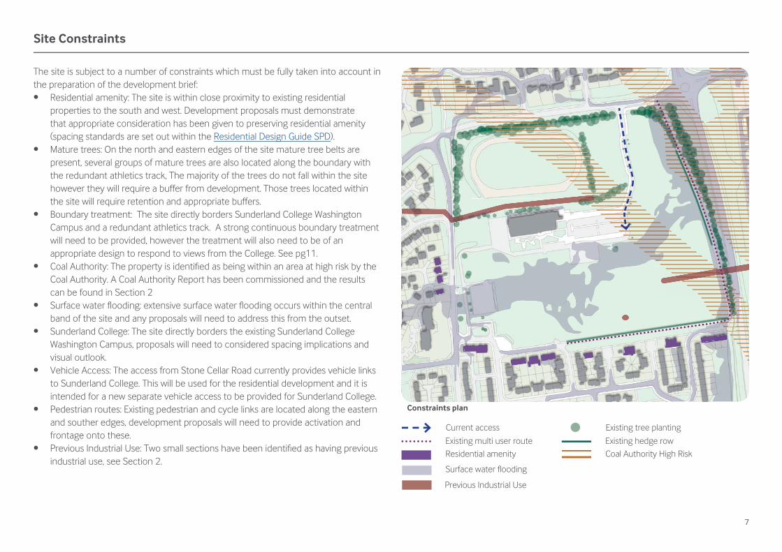
The site is subject to a number of constraints which must be fully taken into account in the preparation of the development brief:• Residential amenity: The site is within close proximity to existing residential
properties to the south and west. Development proposals must demonstrate that appropriate consideration has been given to preserving residential amenity (spacing standards are set out within the Residential Design Guide SPD).
• Mature trees: On the north and eastern edges of the site mature tree belts are present, several groups of mature trees are also located along the boundary with the redundant athletics track, The majority of the trees do not fall within the site however they will require a buffer from development. Those trees located within the site will require retention and appropriate buffers.
• Boundary treatment: The site directly borders Sunderland College Washington Campus and a redundant athletics track. A strong continuous boundary treatment will need to be provided, however the treatment will also need to be of an appropriate design to respond to views from the College. See pg11.
• Coal Authority: The property is identifi ed as being within an area at high risk by the Coal Authority. A Coal Authority Report has been commissioned and the results can be found in Section 2
• Surface water fl ooding: extensive surface water fl ooding occurs within the central band of the site and any proposals will need to address this from the outset.
• Sunderland College: The site directly borders the existing Sunderland College Washington Campus, proposals will need to considered spacing implications and visual outlook.
• Vehicle Access: The access from Stone Cellar Road currently provides vehicle links to Sunderland College. This will be used for the residential development and it is intended for a new separate vehicle access to be provided for Sunderland College.
• Pedestrian routes: Existing pedestrian and cycle links are located along the eastern and souther edges, development proposals will need to provide activation and frontage onto these.
• Previous Industrial Use: Two small sections have been identifi ed as having previous industrial use, see Section 2.
Current access
Existing multi user routeResidential amenity
Previous Industrial Use
Surface water fl ooding
Site Constraints
Constraints plan
Existing tree planting
Existing hedge rowCoal Authority High Risk
8
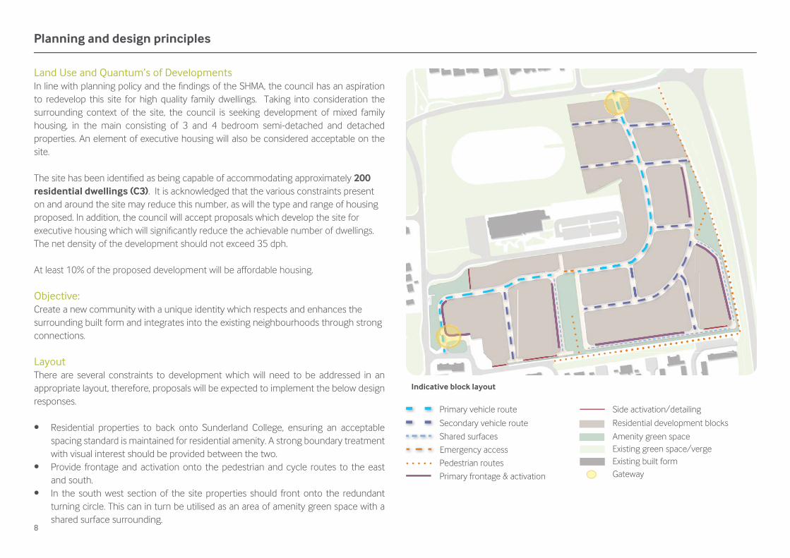
Land Use and Quantum’s of DevelopmentsIn line with planning policy and the fi ndings of the SHMA, the council has an aspiration to redevelop this site for high quality family dwellings. Taking into consideration the surrounding context of the site, the council is seeking development of mixed family housing, in the main consisting of 3 and 4 bedroom semi-detached and detached properties. An element of executive housing will also be considered acceptable on the site.
The site has been identifi ed as being capable of accommodating approximately 200 residential dwellings (C3). It is acknowledged that the various constraints present on and around the site may reduce this number, as will the type and range of housing proposed. In addition, the council will accept proposals which develop the site for executive housing which will signifi cantly reduce the achievable number of dwellings. The net density of the development should not exceed 35 dph.
At least 10% of the proposed development will be affordable housing.
Objective:Create a new community with a unique identity which respects and enhances the surrounding built form and integrates into the existing neighbourhoods through strong connections.
LayoutThere are several constraints to development which will need to be addressed in an appropriate layout, therefore, proposals will be expected to implement the below design responses.
• Residential properties to back onto Sunderland College, ensuring an acceptable spacing standard is maintained for residential amenity. A strong boundary treatment with visual interest should be provided between the two.
• Provide frontage and activation onto the pedestrian and cycle routes to the east and south.
• In the south west section of the site properties should front onto the redundant turning circle. This can in turn be utilised as an area of amenity green space with a shared surface surrounding.
Planning and design principles
Indicative block layout
Primary vehicle route
Secondary vehicle route
Shared surfaces
Pedestrian routes
Primary frontage & activation
Side activation/detailing
Residential development blocks
Amenity green spaceExisting green space/vergeExisting built formGateway
Emergency access
9
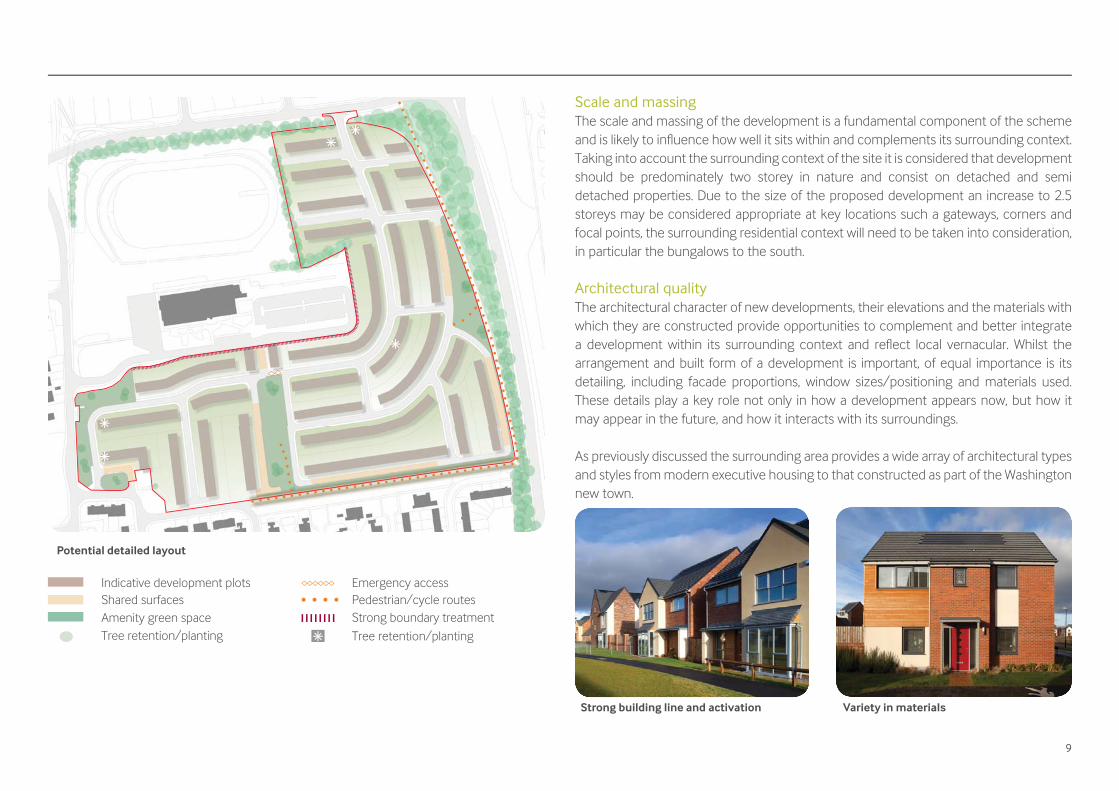
Scale and massingThe scale and massing of the development is a fundamental component of the scheme and is likely to infl uence how well it sits within and complements its surrounding context. Taking into account the surrounding context of the site it is considered that development should be predominately two storey in nature and consist on detached and semi detached properties. Due to the size of the proposed development an increase to 2.5 storeys may be considered appropriate at key locations such a gateways, corners and focal points, the surrounding residential context will need to be taken into consideration, in particular the bungalows to the south.
Architectural qualityThe architectural character of new developments, their elevations and the materials with which they are constructed provide opportunities to complement and better integrate a development within its surrounding context and refl ect local vernacular. Whilst the arrangement and built form of a development is important, of equal importance is its detailing, including facade proportions, window sizes/positioning and materials used. These details play a key role not only in how a development appears now, but how it may appear in the future, and how it interacts with its surroundings.
As previously discussed the surrounding area provides a wide array of architectural types and styles from modern executive housing to that constructed as part of the Washington new town.
Strong building line and activation Variety in materials
Potential detailed layout
Tree retention/planting
Pedestrian/cycle routesStrong boundary treatment
Shared surfacesAmenity green spaceTree retention/planting
Indicative development plots Emergency access

10
In line with design best practice, proposals for the site should use a modern architectural design which creates a unique character whilst complementing its surroundings through the use of detailing, scale and materials.
The large scale nature of the development the inclusion of character areas should be sought to create a varied built form and add interest. This should be achieved through the inclusion of range of building types, frontages, materials, green spaces and a route hierarchy
Building types and frontagesThe building types and frontages provided within a development will determine how well streets and spaces are animated and defi ned.
The site will provide a large scale development and as such the inclusion of a range of character areas and building types will be necessary to create a legible and varied development, these will include:
• Landmark Buildings - used to defi ne key gateways and focal points, the architectural style differs from other house types to ensure the properties stand out.
• Corner Turning - Inclusion of dual aspect frontage with fenestration and detailing present on all elevations which present onto public realm.
There should be an aim to establish continuous frontages to streets and introduce a varied sense of street enclosure that in turn should maximise the overlooking and natural surveillance of the public realm, in particular the existing pedestrian/cycle routes bordering the site.
Proposals which feature large blank, inactive elevations which front onto areas of public realm will be resisted, as will those which offer a poor or weak relationship with public realm at ground level.
MaterialsThe choice of materials to be used should also be a key consideration in the design process. Materials which require signifi cant levels of maintenance, which are not durable, and which are likely to age/weather badly should be avoided. Only materials which are developed to the highest possible specifi cation and are durable to the changeable climate of the UK should be used. A varied pallet of materials should be provided to create a range of house types.
Amenity Open Space, landscaping and the public realmAmenity opens space should be provided throughout the development and will be of a size and designed to encourage social interaction and form usable spaces which provide areas for informal activity and play. The minimum provision of amenity open space provided within the development will be determined by policy H21 of the adopted UDP.
Proposals for SUDs should not impact on the provision of amenity greenspace within the site. Proposals which do not provide adequate levels of usable space will not be considered appropriate.
The suitability of any proposed scheme is highly dependant on the quality of any landscaping works associated with the development, both in terms of improving the aesthetic value of the setting of the site, but also as a meaningful mitigation tool to protect the amenity of those within and around the development.
Public realm Amenity open space
11
The council envisages proposals to provide easily maintained hard and soft landscaping treatment to all public areas within the site. There should also be a legible environment established that is easy to move around, including gateways, landmarks and identifi able nodes through a sequence of high quality and connected public realm spaces, focal points and routes.
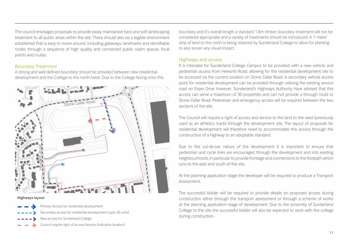
Boundary TreatmentA strong and well defined boundary should be provided between new residential development and the College to the north/west. Due to the College facing onto this
boundary and it’s overall length a standard 1.8m timber boundary treatment will not be considered appropriate and a variety of treatments should be introduced. A 1 meter strip of land to the north is being retained by Sunderland College to allow for planting to also lessen any visual impact.
Highways and accessIt is intended for Sunderland College Campus to be provided with a new vehicle and pedestrian access from Heworth Road, allowing for the residential development site to be accessed via the current location on Stone Cellar Road. A secondary vehicle access point for residential development can be provided through utilising the existing service road on Essex Drive however, Sunderland’s Highways Authority have advised that this access can serve a maximum of 30 properties and can not provide a through route to Stone Cellar Road. Pedestrian and emergency access will be required between the two sections of the site.
The Council will require a right of access and service to the land to the west (previously used as an athletics track) through the development site. The layout of proposals for residential development will therefore need to accommodate this access through the construction of a highway to an adoptable standard.
Due to the cul-de-sac nature of the development it is important to ensure that pedestrian and cycle links are encouraged through the development and into existing neighbourhoods, in particular to provide frontage and connections to the footpath which runs to the east and south of the site.
At the planning application stage the developer will be required to produce a Transport Assessment.
The successful bidder will be required to provide details on proposed access during construction either through the transport assessment or through a scheme of works at the planning application stage of development. Due to the proximity of Sunderland College to the site the successful bidder will also be expected to work with the college during construction.
Highways layout
Stone Cellar Road
Hew
orth
Roa
d
Primary Access for residential development
Secondary access for residential development (upto 30 units)
New access for Sunderland College.
Council require right of access/service (indicative location)

12
ParkingParking must be well designed and integrated into the development and contribute to the overall quality of the public realm. Proposals should create an environment which is not dominated by car parking and follow the principles set out within the Residential Design Guide SPD (excluding spacing standards 10G). Parking should be provided at a rate of: • One space per property up to 3 bedrooms• Two spaces per property 4 bedroom +• One visitor parking space per three properties.
Parking for visitors should be evenly distributed throughout the development with each space being in reasonable proximity to the group of dwellings it is intended to serve.
There is an aim to provide parking which will add to the overall quality and character of the development. Developments should avoid the dominant use of integrated garages and areas of hard-standing for parked vehicles which front the street in order to create a high quality public realm, creating a safer pedestrian environment.
SustainabilitySustainability in its widest sense should be fundamental to any development proposals. The site has the potential to demonstrate Sunderland City Council’s commitment to sustainable, low carbon building. It is therefore particularly important that the principles
behind eco-friendly, low carbon development are fully explored and integrated into the development. The design should be informed by a commitment to sustainability and energy conservation issues, making prudent and effi cient use of natural resources and materials.
Sustainable Urban DrainageDevelopment proposals will have to ensure the integration of SUDs to manage surface water drainage. The drainage requirements of the site should be informed by a detailed assessment of the existing drainage regime in the area and a site Flood Risk Assessment. SUDs for greenfi eld discharge rates should be incorporated in the earliest stages of the site design. Arrangements must be put in place for the whole life management and maintenance of the SUDs.
EcologyDue to the current partial greenfi eld nature of the site a Preliminary Ecological Appraisal (PEA) will be required to be submitted at the pre-application stage of the development.
It should be noted that surveys can only be carried out during certain months and planning applications cannot be validated or determined without the appropriate survey information and assessment report. For instance bat surveys can only be undertaken between May and August.
Archaeological The site lies immediately adjacent to Great Usworth medieval village which dates back to at least 1183 AD.
A previous archaeological desk based assessment produced in 2007 concluded that the site was probably agricultural land during the medieval and post medieval periods. The site was not developed until High Usworth School was built in 1967. Therefore there is a possibility that some evidence of the medieval village and prehistoric remains surviving on the site.
Sustainable Urban Drainage Parking alternatives

13
A geophysical survey would usually be recommended, however the site has been levelled to create school playing fi elds and geophysics is unlikely to be successful. Instead archaeological evaluation trial trenching and a watching brief will be required.
S106 ContributionsPlayA fi nancial contribution of £701 per dwelling will be required to be made to the City Council for the provision of new play facilities or the improvement / maintenance of existing play facilities where appropriate.
Affordable Housing10% affordable housing will be required on site, of which 75% affordable rent and 25% intermediate housing.
EducationContributions will also be sought towards education and increasing capacity within the area.
EcologyDeveloper contributions towards biodiversity enhancement measures in the wider area will also be sought; in-keeping with local and national policy to improve green infrastructure networks and ensure a net gain in biodiversity. The above contributions are subject to increase / indexation / change and are not exhaustive.

14
Section Two: Tender process and submission requirements

15
Additional information
Ground conditions Phase one site investigations have been carried out, the full report is available on request, please contact Louise Whitaker on (0191) 561 2633. The conclusions of the report are provided below.
Contamination and remediationThe risk of signifi cant contamination being present is considered to be moderate. The highest risk areas are considered to be the area of the former Usworth Comprehensive School, area of fi lled ground to the north and the extent of the former open cast site. Potential remediation may include capping in areas of gardens or soft landscaping and gas protection measures may be required.
FoundationsA preliminary assessment of the likely ground conditions within the development area suggests that subject to proposed site levels and any requirement for injection grouting of shallow worked coal seams, conventional shallow spread or trench fi ll foundations should generally be suitable for low rise housing, in large parts of the site, bearing within minimum medium strength glacial clay. In areas of potential deep fi ll (former opencast, school, athletics track fi ll area) deep foundations such as vibro stone columns or piles may be better suited to transmit structural loads to a competent bearing stratum.
Development proposals will need to take into consideration the possible presence of the opencast high wall which may present a sterile area to development due to the complex technical issues for foundations within such areas.
Foundation depth in cohesive soils should be determined by reference to NHBC guidance, with appropriate deepening near trees and hedges. As the site was formerly developed, all new foundations must extend below the depth of historical foundations.
Floor SlabsGround bearing fl oor slabs may be feasible for a large number of properties subject to the thickness of the made ground, the potential for soil swelling associated with trees and the ground gas regime. In areas where made ground is greater than 600mm thick, in areas where soil swelling could occur or where gas protection measures are required, then suspended fl oor slabs will be required.
MiningBased on a review of published information, it is concluded that there is a low to moderate risk of the site being affected by shallow unrecorded coal mining in the Usworth Seam. It is recommended that a rotary drilling investigation is carried out to confi rm the geology with respect to shallow (<30m) coal seams. Trial trenching and deeper boreholes should be undertaken to confi rm the location of the former opencast highwall and depth to the base of the workings.
16
Hazardous GasThere is considered to be a moderate risk from ground gas arising from made ground, shallow underground coal mining and the former opencast workings. The site lies within an area in which radon protection measures are not required.
Sustainable Urban Drainage Systems (SUDS) FeasibilityThe superfi cial deposits beneath the site are shown to comprise low permeability glacial till. Infi ltration coeffi cients for these soil types are typically low. Therefore, at this stage soakaway drainage is not considered appropriate for new developments. However, it is considered that if potentially good infi ltration media is identifi ed during the intrusive investigation infi ltration testing should be undertaken.
Recommendations for Ground InvestigationIn order to establish the environmental risk based on the fi ndings the following works are recommended:• Intrusive ground investigation in the form of trial pits to assess shallow ground
conditions, and obtain samples for laboratory analysis;• Mini percussive boreholes to assess shallow ground conditions, perform insitu
testing and sampling across the site and to confi rm areas of potential deeper made ground;
• Installation of gas monitoring standpipes and monitoring for a minimum of 6 visits over a three-month period;
• Rotary investigation to determine presence and potential risk of shallow unrecorded mine workings;
• Cable percussive boreholes and trial trenching to locate the extents of the former opencast workings;
• Laboratory chemical testing of soils to confi rm or otherwise the fi ndings of the Conceptual Site Model and enable a generic quantitative risk assessment to be carried out;
• Factual and interpretative reporting, providing recommendations for the existing site and any future development.
ServicesThe bidders should make their own enquiries about the availability of services.
TenureThe council owns the freehold interest in the site under title TY480008. The site will be made available with vacant possession.
Brief terms of salePurchase PriceThe Gross Offer will be subject to any reduction to refl ect abnormal building costs that may be agreed in accordance with the Abnormal Costs Schedule attached Appendix 1 of this brief. Any known costs including S106 and issues identifi ed within the phase one Site Investigations will not be considered as abnormals and should be accounted for before the Gross Offer.
ConditionsThe sale will be conditional on:• Contract exchanged within 8 weeks of instructing solicitors. Sunderland City
Council will withdraw from sale if not achieved. • Pre-application stage two permission• Planning permission • Surveys and investigations satisfactory to the buyer • Agreement of abnormal costs • Proof of funds.
The council reserves the right to withdraw from the sale
Obligation to develop (call option)If the development of the site has not begun within 12 months of the date of completion (identifi ed within the bid submission) the council shall have the option to buy back the land at the purchase price. Any costs incurred by the developer will be at their own risk.
17
FeesThe purchaser will be responsible for the payment of the council’s surveyor’s fees of 2.5% + VAT of the gross offer in addition to the council’s legal fees the higher of 0.5% + VAT of the gross offer or £2,050 + VAT. Fees will be payable on the exchange of contracts and will not be refunded in the event the sale does not proceed to completion.
A 10% refundable deposit will also be payable at the exchange of contracts. The deposit will be refundable in the event the conditions can not be satisfi ed, provided that the developer has used reasonable endeavours to satisfy the conditions.
PlanningPre-application Pre-application discussions are an opportunity for the Councils key stakeholders and developers to work together to consider a proposed scheme in detail and give advice on any issues that may affect the proposal.
The council have already sought pre-application stage one advice from Development Management for the development of the site. The preferred developer will be expected to submit their proposal for pre-application stage two advice.
Further advice on the pre-app process can be obtained from: https://www.sunderland.gov.uk/planningadvice
Complementary Council ServicesBuilding Control It is assumed that the purchaser will use the councils Building Control service subject toa competitive quote being provided by the council for this function.
As the Planning and Building Control teams operate as a unifi ed service, the use of the councils Building Control services will help to provide a seamless passage through the regulatory process. SCC Building Control offer a bespoke service to clients, offering free Building Regulation pre-submission advice to developers on design and compliance with Building Regulations. This can avoid costly delays in the programme and errors on site. Building controls fees are extremely competitive.
Contact the Building Control Team on (0191) 561 1550 for further advice and to speak to a surveyor.
Developer servicesThe Infrastructure Commercial Services (ICS) section within Sunderland City Council offers design services relating to all developments with a highways element. This can include the creation of new highway or the modifi cation of existing highway which would be covered under Section 38 & 278 of the Highways Act 1980.
The ICS section can guarantee adoptable designs fi rst time for all highway layouts and provide the latest adoptable construction criteria. Furthermore should SCCs Highways Operations section be contracted to carry the construction works then a Bond of Surety will not be required in relation to the required Highways Agreement.
For further details contact the ICS section on 0191 561 7969.
18
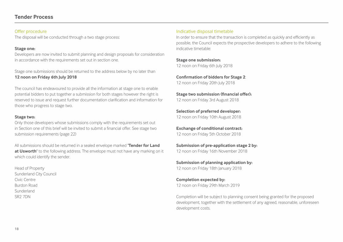
Tender Process
Offer procedureThe disposal will be conducted through a two stage process:
Stage one:Developers are now invited to submit planning and design proposals for consideration in accordance with the requirements set out in section one.
Stage one submissions should be returned to the address below by no later than 12 noon on Friday 6th July 2018
The council has endeavoured to provide all the information at stage one to enable potential bidders to put together a submission for both stages however the right is reserved to issue and request further documentation clarifi cation and information for those who progress to stage two.
Stage two:Only those developers whose submissions comply with the requirements set out in Section one of this brief will be invited to submit a fi nancial offer. See stage two submission requirements (page 22)
All submissions should be returned in a sealed envelope marked ‘Tender for Land at Usworth’ to the following address. The envelope must not have any marking on it which could identify the sender.
Head of Property Sunderland City Council Civic Centre Burdon Road Sunderland SR2 7DN
Indicative disposal timetableIn order to ensure that the transaction is completed as quickly and effi ciently as possible, the Council expects the prospective developers to adhere to the following indicative timetable:
Stage one submission:12 noon on Friday 6th July 2018
Confi rmation of bidders for Stage 2:12 noon on Friday 20th July 2018
Stage two submission (fi nancial offer):12 noon on Friday 3rd August 2018
Selection of preferred developer:12 noon on Friday 10th August 2018
Exchange of conditional contract:12 noon on Friday 5th October 2018
Submission of pre-application stage 2 by:12 noon on Friday 16th November 2018
Submission of planning application by:12 noon on Friday 18th January 2018
Completion expected by:12 noon on Friday 29th March 2019
Completion will be subject to planning consent being granted for the proposed development, together with the settlement of any agreed, reasonable, unforeseen development costs.
19
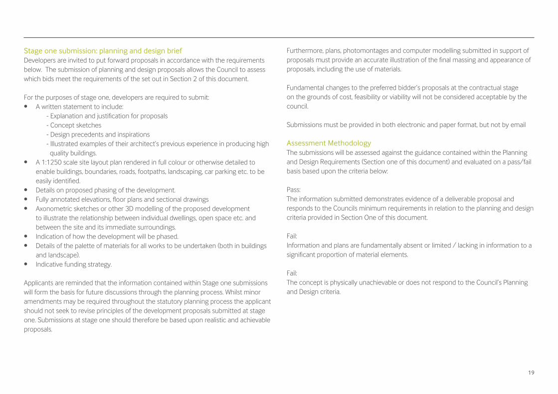
Stage one submission: planning and design briefDevelopers are invited to put forward proposals in accordance with the requirements below. The submission of planning and design proposals allows the Council to assess which bids meet the requirements of the set out in Section 2 of this document.
For the purposes of stage one, developers are required to submit:• A written statement to include:
- Explanation and justifi cation for proposals- Concept sketches- Design precedents and inspirations- Illustrated examples of their architect’s previous experience in producing high quality buildings.
• A 1:1250 scale site layout plan rendered in full colour or otherwise detailed to enable buildings, boundaries, roads, footpaths, landscaping, car parking etc. to be easily identifi ed.
• Details on proposed phasing of the development.• Fully annotated elevations, fl oor plans and sectional drawings• Axonometric sketches or other 3D modelling of the proposed development
to illustrate the relationship between individual dwellings, open space etc. and between the site and its immediate surroundings.
• Indication of how the development will be phased.• Details of the palette of materials for all works to be undertaken (both in buildings
and landscape).• Indicative funding strategy.
Applicants are reminded that the information contained within Stage one submissions will form the basis for future discussions through the planning process. Whilst minor amendments may be required throughout the statutory planning process the applicant should not seek to revise principles of the development proposals submitted at stage one. Submissions at stage one should therefore be based upon realistic and achievable proposals.
Furthermore, plans, photomontages and computer modelling submitted in support of proposals must provide an accurate illustration of the fi nal massing and appearance of proposals, including the use of materials.
Fundamental changes to the preferred bidder’s proposals at the contractual stage on the grounds of cost, feasibility or viability will not be considered acceptable by the council.
Submissions must be provided in both electronic and paper format, but not by email
Assessment MethodologyThe submissions will be assessed against the guidance contained within the Planning and Design Requirements (Section one of this document) and evaluated on a pass/fail basis based upon the criteria below:
Pass: The information submitted demonstrates evidence of a deliverable proposal and responds to the Councils minimum requirements in relation to the planning and design criteria provided in Section One of this document.
Fail:Information and plans are fundamentally absent or limited / lacking in information to a signifi cant proportion of material elements.
Fail:The concept is physically unachievable or does not respond to the Council’s Planning and Design criteria.
20
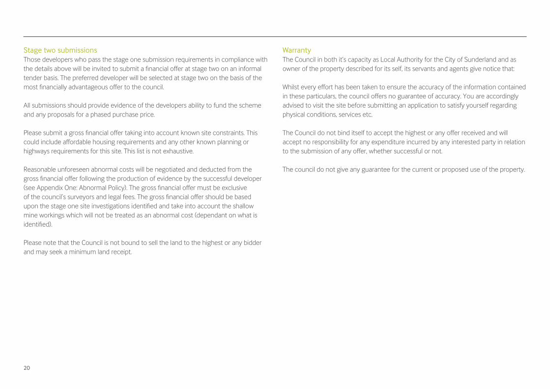
Stage two submissionsThose developers who pass the stage one submission requirements in compliance with the details above will be invited to submit a fi nancial offer at stage two on an informal tender basis. The preferred developer will be selected at stage two on the basis of the most fi nancially advantageous offer to the council.
All submissions should provide evidence of the developers ability to fund the scheme and any proposals for a phased purchase price.
Please submit a gross fi nancial offer taking into account known site constraints. This could include affordable housing requirements and any other known planning or highways requirements for this site. This list is not exhaustive.
Reasonable unforeseen abnormal costs will be negotiated and deducted from the gross fi nancial offer following the production of evidence by the successful developer (see Appendix One: Abnormal Policy). The gross fi nancial offer must be exclusive of the council’s surveyors and legal fees. The gross fi nancial offer should be based upon the stage one site investigations identifi ed and take into account the shallow mine workings which will not be treated as an abnormal cost (dependant on what is identifi ed).
Please note that the Council is not bound to sell the land to the highest or any bidder and may seek a minimum land receipt.
WarrantyThe Council in both it’s capacity as Local Authority for the City of Sunderland and as owner of the property described for its self, its servants and agents give notice that:
Whilst every effort has been taken to ensure the accuracy of the information contained in these particulars, the council offers no guarantee of accuracy. You are accordingly advised to visit the site before submitting an application to satisfy yourself regarding physical conditions, services etc.
The Council do not bind itself to accept the highest or any offer received and will accept no responsibility for any expenditure incurred by any interested party in relation to the submission of any offer, whether successful or not.
The council do not give any guarantee for the current or proposed use of the property.

21
Appendix One: Abnormal policy
22
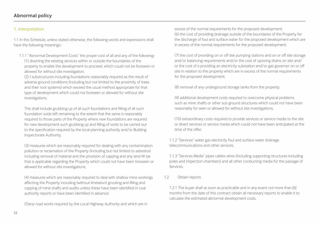
1. Interpretation
1.1 In this Schedule, unless stated otherwise, the following words and expressions shall have the following meanings:-
1.1.1 “Abnormal Development Costs” the proper cost of all and any of the following:-(1) diverting the existing services within or outside the boundaries of the property to enable the development to proceed, which could not be foreseen or allowed for without site investigation;(2) ) substructures including foundations reasonably required as the result of adverse ground conditions (including but not limited to the proximity of trees and their root systems) which exceed the usual method appropriate for that type of development which could not foreseen or allowed for without site investigations.
This shall include grubbing up of all such foundations and fi lling of all such foundation voids left remaining to the extent that the same is reasonably required to those parts of the Property where new foundations are required for new development such grubbing up and fi lling of voids to be carried out to the specifi cation required by the local planning authority and/or Building Inspectorate Authority;
(3) measures which are reasonably required for dealing with any contamination pollution or reclamation of the Property (including but not limited to asbestos) including removal of material and the provision of capping and any land fi ll tax that is applicable regarding the Property which could not have been foreseen or allowed for without site investigations;
(4) measures which are reasonably required to deal with shallow mine workings affecting the Property including (without limitation) grouting and fi lling and capping of mine shafts and audits unless these have been identifi ed in coal authority reports or have been identifi ed in advance;
(5)any road works required by the Local Highway Authority and which are in
excess of the normal requirements for the proposed development;(6) the cost of providing drainage outside of the boundaries of the Property for the discharge of foul and surface water for the proposed development which are in excess of the normal requirements for the proposed development;
(7) the cost of providing on or off site pumping stations and on or off site storage and/or balancing requirements and/or the cost of upsizing drains on site and/or the cost of a providing an electricity substation and/or gas governor on or off site in relation to the property which are in excess of the normal requirements for the proposed development;
(8) removal of any underground storage tanks from the property;
(9) additional development costs required to overcome physical problems such as mine shafts or other sub ground structures which could not have been reasonably for seen or allowed for without site investigations;
(10) extraordinary costs required to provide services or service media to the site or divert services or service media which could not have been anticipated at the time of the offer;
1.1.2 “Services” water gas electricity foul and surface water drainage telecommunications and other services.
1.1.3 “Services Media” pipes cables wires (including supporting structures including poles and inspection chambers) and all other conducting media for the passage of Services.
1.2 Obtain reports
1.2.1 The buyer shall as soon as practicable and in any event not more than [6] months from the date of this contract obtain all necessary reports to enable it to calculate the estimated abnormal development costs.
Abnormal policy

23
1.2.2 The Seller (if demanded hereafter by the Buyer) hereby grants a licence to the Buyer and its contractors to enter onto the Property with or without vehicles and machinery to carry out the Investigations on the following conditions:-
1.2.2.1 the Buyer shall give reasonable notice in writing to the Seller before entering the Property of at least 10 Working Days including details of the nature of the investigations to be carried out on the Property and the identity of the contractors carrying these out.
1.2.2.2 the Buyer and its contractors shall use the main entrance as specifi ed by the Seller for access to and egress from the Property and shall keep the Property secure and safe for members of the public at all times.
1.2.2.3 the Buyer and its contractors shall fi ll in bore holes and excavations as soon as practicable and leave the Property in the same state and condition as at the date of this Contract.
1.2.2.4 the Buyer and its contractors shall not allow any unnecessary damage to the Property and shall take all reasonable steps to identify and avoid damage to or disruption of Services or Services Media.
1.2.2.5 the Buyer and its contractors shall clear up immediately any earth or other materials deposited on the highway by its vehicles plant and machinery.
1.2.2.6 the Buyer and its contractors shall observe any further conditions which the Seller may attach to this Licence at its absolute discretion and without prejudice to the foregoing the seller may require that a method statement be supplied and approved before any or all of the investigations commence.
1.2.2.7 the Buyer shall keep the Seller fully indemnifi ed against all actions, claims, demands and proceedings taken or made against the Seller and all costs, damages, expenses, liabilities and losses incurred by the Seller as a consequence of the Investigations or other activities of the Buyer on the Property.
1.3 Agreement of Abnormal Development Costs
1.3.1 The Buyer shall within ten Working Days of receiving the last of any necessary reports serve a notice (“the Costs Notice”) on the Seller (with copies of the Reports) detailing the estimated amount of the Abnormal Development Costs and requesting that the Seller shall advise the Buyer whether this estimated amount is agreed.
1.3.2 The Seller shall consider the Buyer’s estimate of the Abnormal Development Costs and advise the Buyer whether this estimate is agreed within the period of 20 Working Days following service of the Costs Notice on the Seller. The estimate shall not be treated as agreed unless and until the Seller’s Conveyancer confi rms in writing that the relevant committee cabinet or offi cer acting in accordance with delegated powers of the Seller has approved the revised Purchase Price refl ecting the amount of the Abnormal Development Costs.
1.4 Failure to agree Abnormal Development Costs
1.4.1 If the Seller disagrees with the Buyer’s estimate of the Abnormal Development Costs then (save where the costs condition has been waived by the Buyer pursuant to clause 1.5.4 of this Agreement) unless the parties are able to agree the Abnormal Development Costs within a further period of twenty working days together with such further period stipulated by the Seller as necessary to satisfy the Seller’s internal procedures either party may elect to rescind this Agreement by written notice to that effect on the other (but without prejudice to the rights of either party in respect of any antecedent breach).
1.4.2 If the Seller fails to serve a notice within the relevant period set out in paragraph 1.3.2 then the Seller shall be deemed to disagree with the buyers estimate of abnormal development costs and the provisions of paragraph 1.4.1 shall apply.

24
1.5 General Obligations
1.5.1 The Buyer agrees that it shall at all times operate an open book policy in relation to the calculation of the Abnormal Development Costs both with regard to the Seller and any independent consultant appointed by the Seller to advise on the information supplied in the Costs Notice. The Seller will not be obliged to sell the site if the abnormal costs go below an acceptable minimum land value
1.5.2 Without prejudice to the generality of paragraph 1.5.1 the Buyer shall provide such information required by the Seller or by such independent consultant appointed by the Seller which they regard as necessary to determine the accuracy or acceptability of the estimated amount of the Abnormal Development Costs.
1.5.3 The Buyer and the Seller mutually agree that they shall deal with each other in the utmost good faith with regard to this Schedule.
1.5.4 Notwithstanding any other provision within this Schedule, the buyer shall at all times be entitled to waive the costs condition of this contract and in the event of such waiver the purchase price shall be deemed to be the gross offer as defi ned by the conditional contract and not be reduced by any purported Abnormal Development Costs.

25
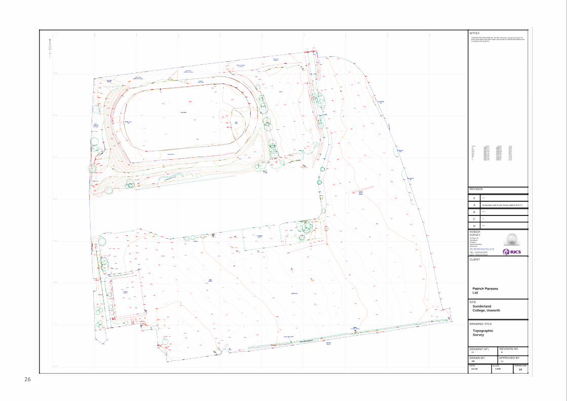
Appendix Two: Topography plan
26
surfacemanhole 300mm
w-e
remnantcricketwicket
sportspitches
sports pitches
rough grass
steeple-chase
grass
GULGULL
LPLPLLLPLPLPLPLPLPLLLPLPLPLPLPLPLPLPLPLP
MHMH
MHMH
MHMH
MHMH
MHMHILILMHMHMHMMHMM
558600N558600N 5555
558650N558650N 5555
558700N558700N 5555
558750N558750N 5555
558800N558800N 5555
558850N558850N 5555
558900N558900N 5555
558950N558950N 5555
559000N559000N 5595590430500E430500E
430550E430550E
430600E430600E
430650E430650E
430700E430700E
430750E430750E
430800E430800E
430850E430850E
430900E430900E
430950E430950E
57.4057.405557.4657.4657 4657 46555
58.8758.87555858555
59.3959.3959 3959 3955559.4259.4259 4259 4255559.4859.4855555
60.1960.196060 19196060 1919100 110 16666
55.7755.7755
55.8855.8855 8855 8855 8855 88
56.3856.385556.5556.5555
7756.0756.07
55.3955.3955
55.6855.6855
55.9655.96
8989898955.855.855 855 8888855
55.5055.5055
55.6855.6855
55.9355.9355
56.1256.12
55.7855.7855
55.6055.6055
55.4855.4855
55.7655.7655
55.9255.9255.9255
56.0556.0555
55.8355.8355
55.7255.7255 7255 7255
55.5155.5155
55.7855.7855
55.9355.9355
56.0456.0455
56.2656.2655 56.0956.0956556 0565555
55.9755.9755
56.1556.1555
56.2656.2655
56.3756.3755
56.1556.1555
55.9055.9055
55.8655.8655
55.8655.8655
55.9355.9355
55.9755.975555.9655.9655
56.2356.235
56.2456.2455
56.2756.2755
56.1856.1855
6.076.07555555
56.3756.3755
56.4556.4555
56.5256.5255
56.7256.7255
56.8056.8055
57.0757.0755
57.0957.0955
57.0757.0755
56.8956.895
.818156.56.55
56.7256.7255
57.1657.1655
57.3257.3255
57.3357.3355
57.3157.3155
57.2457.2455
57.3457.3455
57.2757.2755
57.5357.5355
57.5057.5055
57.5557.555557.5257.52225555552222555252222222222222
57.4857.4855
57.4557.455557.4757.47
57.3557.355557.3357.3333333355 57.3557.3555.3555.35
333333333333
57.3357.3355
57.5157.5155
57.6057.6055555
57.6857.6855
57.8357.8355
58.0058.0055
57.9757.9755
57.8457.8455
57.6657.6655
626257.657.65557.7457.7455
57.8157.81.817.8155
58.0358.0355
58.1758.1755
58.3558.3555
58.5858.5855
58.4158.41585855
58.2858.2855
58.0858.0858 0858 0855
57.8757.8755
57.5557.55MHMHMHMHMHMHMH
58.0658.0655
58.2858.2855
58.4258.4255
58.5758.5755
58.7058.7055
58.7858.78
58.9358.9355
58.8558.8555
58.7758.7755
58.5758.5755
58.4858.4855
58.4258.4258.4258.4242255
58.2258.2255
222258.2258.2255
58.5058.5055
58.7858.7855
58.9458.9455
59.0359.033355
59.2559.2555
59.0459.0455
58.9158.915555555555
58.7658.7655
58.618.6158.58.55
58.6258.6255
58.7358.7355
58.8758.8755
58.9858.9855
58.8958.8955
59.2659.2655
60.5960.5966
9.049.04595999
59.1459.1455
59.1759.1759.1759.1755
59.2259.2255
59.1859.1855
59.0959.0955
59.1059.1055
59.0459.0455
59.0859.0855
59.0359.0355
59.0959.0955
59.1359.1355
59.0759.0755
59.0759.0755
59.0459.0455
58.9658.9655
59.0459.0455
57.5857.585557.7557.7555
57.8457.84
57.6757.6755 57.4957.4955
57.1857.1855
58.4858.4855
58.5258.525558.4858.4855
111
57.0
57.00
LL
6.6.
7.817.81
57555
626
58.658.6
88
5858
424222
2222
58.0 58.0
LPLP
59.059.0
59.059.0
LPLPLPLP
59.059.0
59.0
59.0
33
55
77
56.0
56.0
5656.0.0
59.0
59.0
59595959
surfacesurfacemmmanhole 300mmmanhole 300mmmm
w-ew-eMHMHMHMHMHMHMH
ntntremnaremna 56.0
560
56.0
560
560
560
560
cricketcricket
5555555
wicketwicket
sportssportspitchespitches
sports pitchessports pitches
rough grassrough grass
steeple-chasesteeple-chase
grassgrass
PAPER SIZESCALE
APPROVED BYDRAWN BY
DRAWING NO.
DATE
SITE
REVISION NO.
CLIENT
C
D
A
B
REVISION
0
NOTES
Patrick ParsonsLtd
SunderlandCollege, Usworth
TopographicSurvey
>> A
AR >>
4-2-18 1:500 A0
N
DRAWING TITLE
>>
Annotation and Cover levels added 30-5-17
>>
>>
>>
ROBSONSURVEY20 Piper RdOvinghamPrudhoeNorthumberlandNE42 6AY
TEL: 01661832997FAX: 01661832997
info @robsonsurvey.co.uk@ y
COORDINATES ARE BASED ON Stn RS1 observed on OS grid and datum.Allsurvey observations have been taken using a scale of 1.00000 and therefore hAveno mapping scale projection.
Station Easting Northing LevelR2 430807.121 558824.407 59.741R3 430807.117 558824.411 59.741R100 430552.632 558699.729 61.895R101 430807.124 558824.418 59.740R102 430817.265 558969.667 58.414R103 430812.179 558788.535 59.423RS1 430603.420 558715.472 58.769RS2 430813.597 558792.119 57.309RV 430807.125 558824.401 59.738T1 430798.368 558866.911 57.304T2 430829.252 558830.215 56.246

For further details and copies in large print and other languages please contact:
Louise Whitaker - Valuation Surveyor
Sunderland City CouncilCivic CentreBurdon RoadSunderlandSR2 7DN
Tel: (0191) 561 2633email: [email protected]