land categories and the land management framework
TRANSCRIPT

Want to know more? We’re here to help
Find us online: lls.nsw.gov.au. You'll find other land management
resources including fact sheets Call us:1300 795 299 and ask for an officer to advise you on land
managementEmail us: [email protected] us: drop into your nearest Local
Land Services office
Land categories and the Land Management Framework
This fact sheet provides guidance for landholders about land categorisation under the Land Management Framework and what that means for native vegetation management. Rural land in NSW is categorised into three main categories: Category 1 (exempt land), Category 2 (regulated land) and Excluded land. There are different native vegetation management options for each category. A native vegetation regulatory map is maintained by the Department of Planning, Industry and Environment.
What do the categories mean?Category 1 - Exempt land is land where native vegetation can be cleared without approval from Local Land Services.Category 2 land is divided into:Category 2 - Regulated land is Category 2 land that is not Vulnerable or Sensitive regulated land. You may need authorisation from Local Land Services to clear native vegetation from rural zoned land in this category.Category 2 - Vulnerable regulated land is land where clearing of native vegetation may not be permitted under the Land Management (Native Vegetation) Code 2018, and a limited range of allowable activities are permitted.Category 2 - Sensitive regulated land is land where clearing is not permitted under the Land Management Code (Native Vegetation) Code 2018, and a limited range of allowable activities is permittedExcluded land is land where the Land Management (Native Vegeation) Code 2018 and allowable activities do not apply.Each land category is determined by various criteria as outlined in the Local Land Services Act 2013 (see Table 1 on page 2)
Can land categories change? You can apply for a review of the categories covering your land and it may be possible in certain circumstances to re-categorise: • if land has been cleared in accordance with a Property
Vegetation Plan (PVP), or development consent or approval, or
• after receiving a Code certificate under the Continuing Use, Equity and Farm Plan parts of the Land Management (Native Vegetation) Code 2018 or
• if land identified as Old Growth or Rainforest has been assessed as not meeting the criteria for those communities.
Rural zoned land in this fact sheet refers to zones RU1, RU2, RU3, RU4 and RU6
Land categories and the Land Management Framework
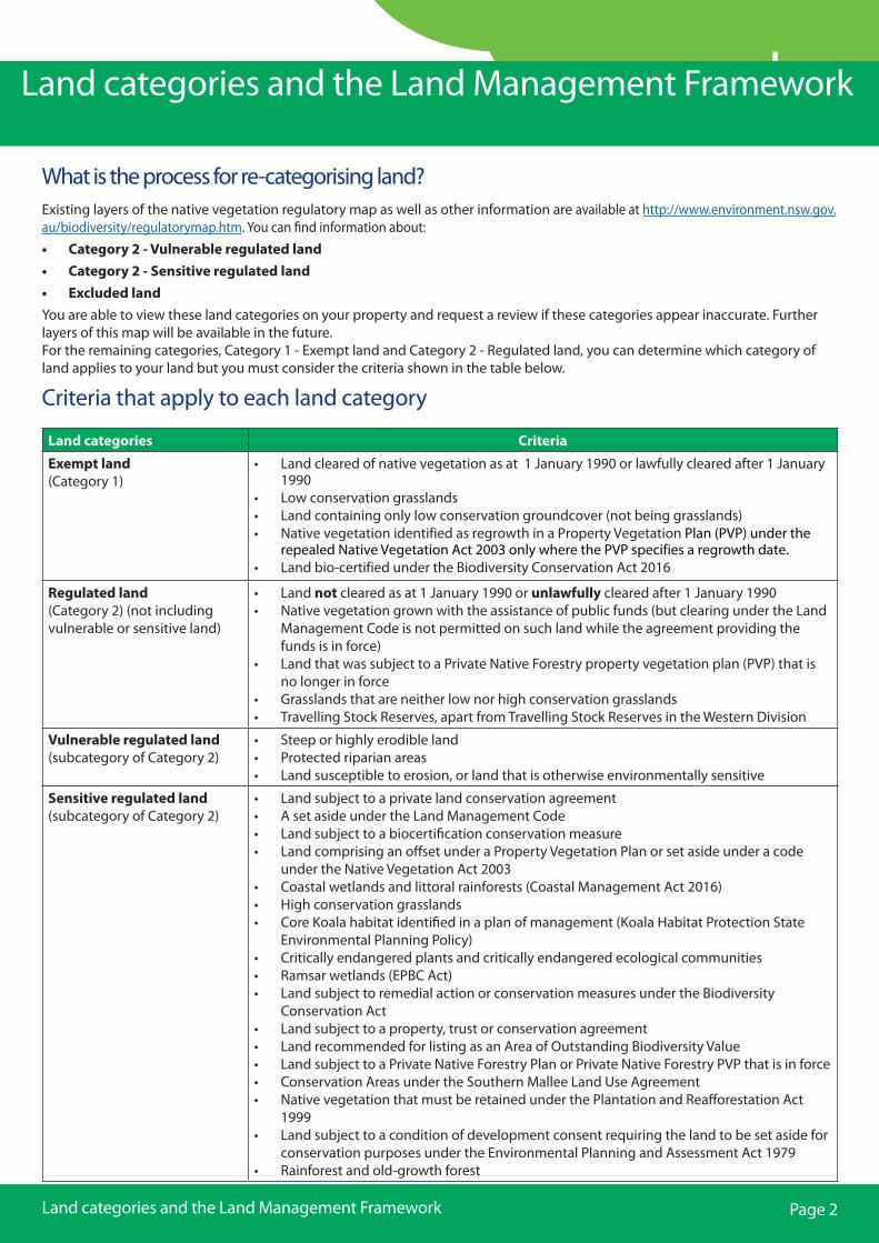
Land categories Criteria
Exempt land (Category 1)
• Land cleared of native vegetation as at 1 January 1990 or lawfully cleared after 1 January 1990
• Low conservation grasslands• Land containing only low conservation groundcover (not being grasslands)• Native vegetation identified as regrowth in a Property Vegetation Plan (PVP) under the
repealed Native Vegetation Act 2003 only where the PVP specifies a regrowth date.• Land bio-certified under the Biodiversity Conservation Act 2016
Regulated land (Category 2) (not including vulnerable or sensitive land)
• Land not cleared as at 1 January 1990 or unlawfully cleared after 1 January 1990• Native vegetation grown with the assistance of public funds (but clearing under the Land
Management Code is not permitted on such land while the agreement providing thefunds is in force)
• Land that was subject to a Private Native Forestry property vegetation plan (PVP) that isno longer in force
• Grasslands that are neither low nor high conservation grasslands• Travelling Stock Reserves, apart from Travelling Stock Reserves in the Western Division
Vulnerable regulated land (subcategory of Category 2)
• Steep or highly erodible land• Protected riparian areas• Land susceptible to erosion, or land that is otherwise environmentally sensitive
Sensitive regulated land (subcategory of Category 2)
• Land subject to a private land conservation agreement• A set aside under the Land Management Code• Land subject to a biocertification conservation measure• Land comprising an offset under a Property Vegetation Plan or set aside under a code
under the Native Vegetation Act 2003• Coastal wetlands and littoral rainforests (Coastal Management Act 2016)• High conservation grasslands• Core Koala habitat identified in a plan of management (Koala Habitat Protection State
Environmental Planning Policy)• Critically endangered plants and critically endangered ecological communities• Ramsar wetlands (EPBC Act)• Land subject to remedial action or conservation measures under the Biodiversity
Conservation Act• Land subject to a property, trust or conservation agreement• Land recommended for listing as an Area of Outstanding Biodiversity Value• Land subject to a Private Native Forestry Plan or Private Native Forestry PVP that is in force• Conservation Areas under the Southern Mallee Land Use Agreement• Native vegetation that must be retained under the Plantation and Reafforestation Act
1999• Land subject to a condition of development consent requiring the land to be set aside for
conservation purposes under the Environmental Planning and Assessment Act 1979• Rainforest and old-growth forest
Land categories and the Land Management Framework
Criteria that apply to each land category
Page 2
Land categories and the Land Management Framework
What is the process for re-categorising land? Existing layers of the native vegetation regulatory map as well as other information are available at http://www.environment.nsw.gov.au/biodiversity/regulatorymap.htm. You can find information about: • Category 2 - Vulnerable regulated land• Category 2 - Sensitive regulated land• Excluded landYou are able to view these land categories on your property and request a review if these categories appear inaccurate. Further layers of this map will be available in the future.For the remaining categories, Category 1 - Exempt land and Category 2 - Regulated land, you can determine which category of land applies to your land but you must consider the criteria shown in the table below.