land surface imaging (lsi) virtual constellation constellation... · – highest priority: the...
TRANSCRIPT
The 24th CEOS Plenary – Rio de Janeiro, Brazil 12-15 October, 2010
Land Surface Imaging (LSI)
Virtual Constellation
Co-Leads: U.S. Geological Survey (USGS),
Indian Space Research Organization (ISRO), and the
Instituto Nacional de Pesquisas Espaciais (INPE)
Presented by: Tom Holm, USGS
(LSI Co-Chair)
Agenda Item 14.3
2 The 24th CEOS Plenary – Rio de Janeiro, Brazil 12-15 October, 2010
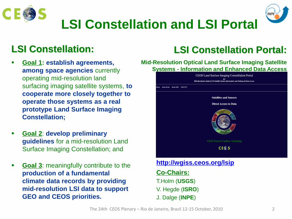
LSI Constellation Portal:
Mid-Resolution Optical Land Surface Imaging Satellite
Systems - Information and Enhanced Data Access
http://wgiss.ceos.org/lsip
LSI Constellation:
Goal 1: establish agreements,
among space agencies currently
operating mid-resolution land
surfacing imaging satellite systems, to
cooperate more closely together to
operate those systems as a real
prototype Land Surface Imaging
Constellation;
Goal 2: develop preliminary
guidelines for a mid-resolution Land
Surface Imaging Constellation; and
Goal 3: meaningfully contribute to the
production of a fundamental
climate data records by providing
mid-resolution LSI data to support
GEO and CEOS priorities.
LSI Constellation and LSI Portal
Co-Chairs:
T.Holm (USGS)
V. Hegde (ISRO)
J. Dalge (INPE)

3 The 24th CEOS Plenary – Rio de Janeiro, Brazil 12-15 October, 2010
Accomplishments and/or Milestones • LSI Portal Enhancements
• LSI Mid-Resolution Optical Guidelines Document
• LSI Freeware Tools
• Support to the GEO Forest Carbon Tracking Task
Current Challenges • GEO FCT
• Potential Data Gap Solutions
• Achieving Constellation Objectives
Requests of CEOS • CEOS Space Agency Data Support to GEO Task AG-07-03: Global
Agricultural Monitoring System of Systems
Presentation Outline

4 The 24th CEOS Plenary – Rio de Janeiro, Brazil 12-15 October, 2010
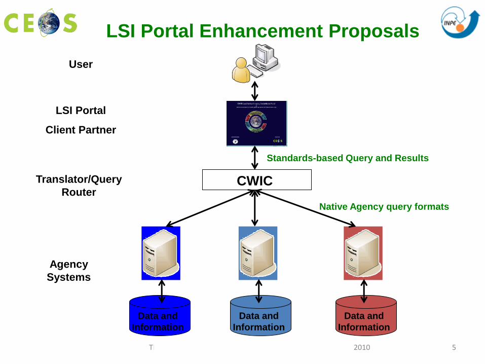
• Expand functionality to include cross-system,
granule-level, search and data retrieval
– Highest priority: The addition of a prototype map-based query
and direct data download capability to the Portal using CWIC as
the interface to the member data systems.
– CWIC will provide an access point for major CEOS agency
catalog systems.
– CWIC will distribute inventory/product searches to the CEOS
agency inventory systems using the agency systems native
protocol.
– Need support for a java programmer to support SIT demo in
2011
LSI Portal Enhancement
5 The 24th CEOS Plenary – Rio de Janeiro, Brazil 12-15 October, 2010
Data and
Information
User
Agency
Systems
Data and
Information
Data and
Information
LSI Portal
Client Partner
Standards-based Query and Results
CWIC
Native Agency query formats
Translator/Query
Router
LSI Portal Enhancement Proposals

6 The 24th CEOS Plenary – Rio de Janeiro, Brazil 12-15 October, 2010
• Addition of new data types or descriptive
information (Second priority)
– Link to Working Group on CAL/VAL portal and others. Value
of having more synergy at the LSI portal level with WGISS and
WGCV, especially as multisource/multisensory applications are
developed. Additional information on calibration coefficients and
spectral response functions (or links to relevant information such
as mission web pages and cal/val sites) would be valuable and
a unique asset to the LSI portal or links to WGCV subgroup on
Infrared and Visible Optical Sensors.
– Expanding the data set, sensor, and platform information as
well as links to order/access systems for other optical land
imaging systems such as MODIS.
LSI Portal Enhancement (continued)

7 The 24th CEOS Plenary – Rio de Janeiro, Brazil 12-15 October, 2010
LSI Portal Publication
• The CEOS- Land Surface Imaging Constellation Portal for GEOSS: A resource for land surface imaging system information and data access.
By Thomas Holm, U.S. Geological Survey; Kevin Gallo, National Oceanic and Atmospheric Administration, and G. Bryan Bailey U.S. Geological Survey (retired).
Posted on May 3rd, 2010 in Articles, Earth Observation, GEOSS/ICEO News, Technology
http://www.earthzine.org/

8 The 24th CEOS Plenary – Rio de Janeiro, Brazil 12-15 October, 2010
• In 2008, the LSI Constellation initiated an effort to define guidelines that define a set of ideal or optimal guidelines for mid-resolution optical mission, instrument, and data policy characteristics.
– It is recognized that no single mission or ground segment would be expected to meet all of these guidelines. Instead, the overall virtual constellation of LSI would together achieve these goals through the combination of their specific subset of specialties and foci.
• Guidelines to be based on the needs of the land imaging user communities (vegetation, solid earth, water, geo-hazards).
• Systems Engineering Office has been supporting the LSI Constellation
– Multiple iterations worked with LSI Co-Chairs
– An assessment of the currently flying instruments and their spectral band coverage is in progress to determine what is already being measured
LSI Mid-Resolution Optical Guidelines

9 The 24th CEOS Plenary – Rio de Janeiro, Brazil 12-15 October, 2010
• Use 1: A CEOS agency has an
instrument already built that they
feel will benefit the LSI Community.
They go to the guidelines
document to learn about where
they would fit with other LSI
instruments and to determine if
they are filling a needed niche.
• Use 2: A CEOS agency would like
to build an instrument to achieve
LSI goals. The instrument design
team goes to the guidelines
document to see what the
instrument characteristics should
be.
• Therefore address
questions such as:
– Who are the users?
– What kinds of instruments?
– What kinds of
measurements?
– What SBAs are related?
– What spectral bands are of
interest?
– What are current missions?
– What are the future
missions?
– What are the guideline
values for measurements?
LSI Mid-Resolution Optical Guidelines

10 The 24th CEOS Plenary – Rio de Janeiro, Brazil 12-15 October, 2010
• The document includes:
– Measurements, User Communities, and SBA’s
– Measurements and Instrument Types
– Measurements and Spectral Bands
– Mid-Resolution Optical Missions
– Missions and Measurements
– Measurement Guidelines
– Measurement Expected Performance
– Systems Analyses
LSI Mid-Resolution Optical Guidelines

11 The 24th CEOS Plenary – Rio de Janeiro, Brazil 12-15 October, 2010
Next Steps
• Draft discussed at Montreal LSI Study Team Workshop, Friday
afternoon, 17 September 2010
• Community review of document by 1 October 2010
• sent to WGISS and WGCV for comment
• Updated draft of document in-work
• Comments from community review being addressed
• Analysis and updates ready for SIT-26 in March 2011
CEOS SEO Points of Contact:
Jennifer Keyes ([email protected])
Brian Killough ([email protected] )
LSI Mid-Resolution Optical Guidelines

12 The 24th CEOS Plenary – Rio de Janeiro, Brazil 12-15 October, 2010
Complete development of freeware
– INPE is developing two different orthorectification tools
– Both tools will be made available as freeware software.
1. Command line tool (windows and linux):
– Two geometrical models: Rigorous Mathematical Model and RPCs
(Rational Polynomial Coefficients)
– already implemented and tested
– documentation (installation and users' manuals) in English are
being revised
– definition of website link for download still pending
LSI Freeware Tools (INPE)
13 The 24th CEOS Plenary – Rio de Janeiro, Brazil 12-15 October, 2010
2. SPRING GIS plug-in (windows and linux)
• Geometrical model: RPCs
• still under development
• to be released with next SPRING version by the end of 2010
• Current version of SPRING: Spring 5.1.6 (www.dpi.inpe.br/spring)
• SPRING: Freeware GIS and remote sensing image
processing system (English, French, Spanish,
Portuguese)
LSI Freeware Tools
14 The 24th CEOS Plenary – Rio de Janeiro, Brazil 12-15 October, 2010
GEO Forest Carbon Tracking
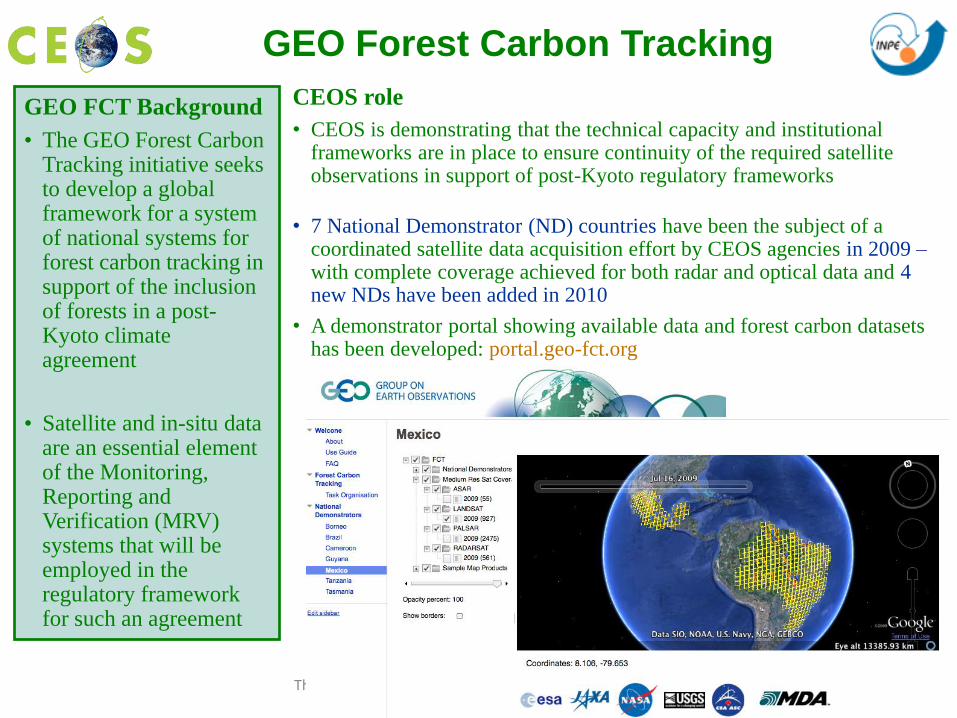
GEO FCT Background
• The GEO Forest Carbon Tracking initiative seeks to develop a global framework for a system of national systems for forest carbon tracking in support of the inclusion of forests in a post-Kyoto climate agreement
• Satellite and in-situ data are an essential element of the Monitoring, Reporting and Verification (MRV) systems that will be employed in the regulatory framework for such an agreement
CEOS role
• CEOS is demonstrating that the technical capacity and institutional frameworks are in place to ensure continuity of the required satellite observations in support of post-Kyoto regulatory frameworks
• 7 National Demonstrator (ND) countries have been the subject of a coordinated satellite data acquisition effort by CEOS agencies in 2009 – with complete coverage achieved for both radar and optical data and 4 new NDs have been added in 2010
• A demonstrator portal showing available data and forest carbon datasets has been developed: portal.geo-fct.org
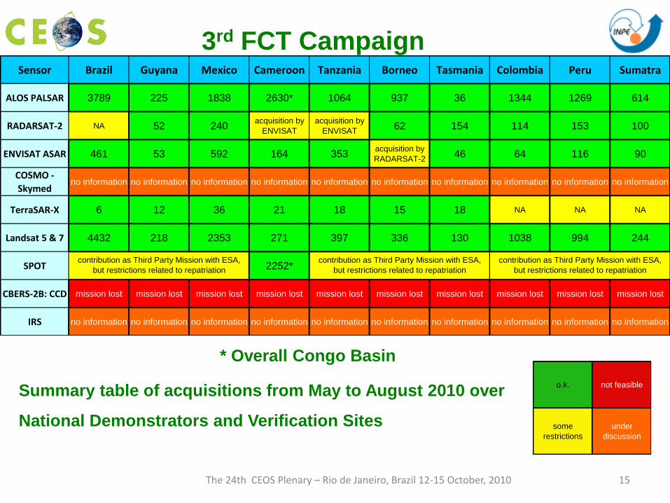
15 The 24th CEOS Plenary – Rio de Janeiro, Brazil 12-15 October, 2010
* Overall Congo Basin
Summary table of acquisitions from May to August 2010 over
National Demonstrators and Verification Sites
o.k. not feasible
some
restrictions
under
discussion
3rd FCT Campaign Sensor Brazil Guyana Mexico Cameroon Tanzania Borneo Tasmania Colombia Peru Sumatra
ALOS PALSAR 3789 225 1838 2630* 1064 937 36 1344 1269 614
RADARSAT-2 NA 52 240acquisition by
ENVISAT
acquisition by
ENVISAT62 154 114 153 100
ENVISAT ASAR 461 53 592 164 353acquisition by
RADARSAT-246 64 116 90
COSMO -
Skymedno information no information no information no information no information no information no information no information no information no information
TerraSAR-X 6 12 36 21 18 15 18 NA NA NA
Landsat 5 & 7 4432 218 2353 271 397 336 130 1038 994 244
SPOT 2252*
CBERS-2B: CCD mission lost mission lost mission lost mission lost mission lost mission lost mission lost mission lost mission lost mission lost
IRS no information no information no information no information no information no information no information no information no information no information
contribution as Third Party Mission with ESA,
but restrictions related to repatriation
contribution as Third Party Mission with ESA,
but restrictions related to repatriation
contribution as Third Party Mission with ESA,
but restrictions related to repatriation

16 The 24th CEOS Plenary – Rio de Janeiro, Brazil 12-15 October, 2010
Current Challenges
• Acquisition strategy for GEO FCT involves a continuation of
and an expanded demonstration mode in 2011 and 2012
– Full Commitment from All CEOS LSI Member Agencies needed
• GEO FCT Gap filling strategy for land imaging data if Landsat 5
and 7 fail prior to LDCM launch.
• Can LSI achieve Objective 1 “…land surfacing imaging satellite
systems, to cooperate more closely together to operate those
systems as a real prototype Land Surface Imaging Constellation.”
– Can the planned “core data systems” operate as a virtual constellation?
• Will Space Agencies adjust acquisition strategies?
• Will future missions adjust sensor/mission plans?
– Will free and open data access policies be adopted by more CEOS
members?

17 The 24th CEOS Plenary – Rio de Janeiro, Brazil 12-15 October, 2010
Requests of CEOS Space Agency Data Support
GEO Task AG-07-03 - Agriculture
• Global Agricultural Monitoring System of Systems, jointly led by Canada, the European Commission, and the United States.
• Provides a much-needed framework for a concerted international effort to improve global agricultural monitoring capabilities and enhance food security through the use of remote sensing data.
• The implementation of the GEO Task AG-07-03 requires free, open, and timely access to satellite data and products for global agriculture monitoring.

18 The 24th CEOS Plenary – Rio de Janeiro, Brazil 12-15 October, 2010
JECAM China (3 sites); JECAM Canada; JECAM Argentina; JECAM Brazil;
JECAM Ethiopia, JECAM Mexico, JECAM Europe-Flevoland, JECAM Ukraine
Establishment of Joint Experiments on Crop
Assessment and Monitoring (JECAM)

19 The 24th CEOS Plenary – Rio de Janeiro, Brazil 12-15 October, 2010
• Request for CEOS Space Agency Data Support to
GEO Task AG-07-03: Global Agricultural Monitoring
System of Systems – Joint Experiments on Crop Assessment and Monitoring (JECAM)
– Letter of request sent on 9 September 2010 by LSI Co-Chairs to LSI
• Seeking CEOS Plenary endorsement
Establishment of Joint Experiments on Crop
Assessment and Monitoring (JECAM)