Land Use and Land Cover Change Detection in Tiruchirappalli District Using Remote Sensing and GIS
8
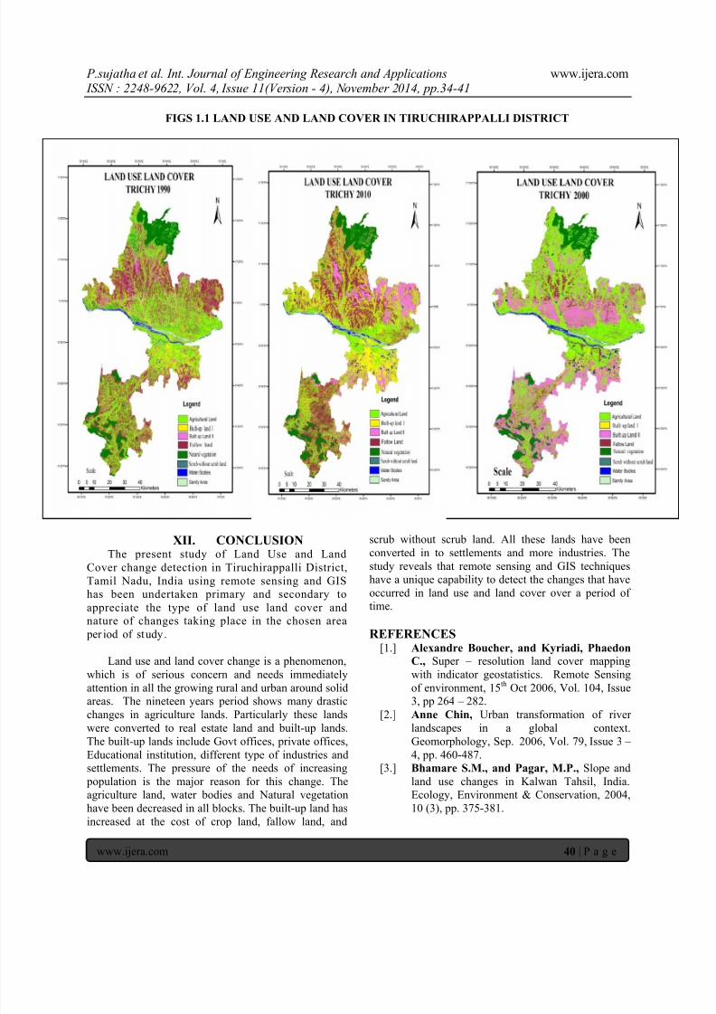
P.sujathaet al. Int. Journal of Engineering Research and Applications www.ijera.com ISSN : 2248-962 2, Vol. 4, Issue 11(Ver sion - 4), N ovember 2 014, pp.34-41 www.ijera.com 34 | Page Land Use and Land Cover Change Detection in Tiruchirappall i District Using Remote Sensing and GIS P.sujatha and Dr.R.Baskaran, N.Hajeeranbeevi Dept of Earth sciences, Tamil University, Thanjavur ABSTRACT Land use and land cover is dominant role in the part of urbanization. As the rapid urbanization led various activities in a region and these changes generally takes place in the agricultural land and caused decrease of arable land .The satellite imageries LANDSAT 5TM (1990), LANDSAT 7ETM (2000) AND LISS 111 (2010) data’s are used. The scales are 1:50,000. 1990, 2000 and 2010 covering a period of 19 years the aerial distribution of the land use and land cover changes has been observed. The changes were identified ,in which the decrease of Agricultural land, Natural vegetation , Scrub la nd and Water body and increase of Built up land, Fallow land, River sand and Without scrub land. The land use and land cover maps are prepared by using GIS software to evaluate the changes and it is showed strong variation. Key words: Land use and land cover changes in Tiruchirappalli district and GIS. I.INTRODUCTION Land is the basic resources of human society. It is the most significant among the natural resources of the country and most of its inhabitants depend on agriculture for their livelihood. Land is being used by people for various purposes. The basic requirement of human society is food. Farmers produce food from the land. The second important basic need of the people is home. It takes a very higher priority in its demand of land. Land use / Land cover exhibits the physical and economical situation of any region. Land use / Land cover determines the standard of living of the people and the natural resources found in a region. The development of human race started to develop from when man started to convert the land cover region to land use. Land use and land cover changes degrade and have an instant impact on the global carbon cycle. The global cycle can add or remove carbon di- oxide from the atmosphere, contributing to climate changes which lead to global warming. The information on land use/land cover patterns, their spatial distribution and changes over a time scale are prerequisite for making development plans. Tiruchirappalli district is an important region in the State and had been a Centre of activities for many historical events from the days of the early Cholas. Rock Fort, Thayumana Swamy, Pillaiyar Temple, Teppakulam, the Nawab’s palace, the Nadir Shah Mosque, Sri Rangam Temple, Thiruvanai Koil, Subramanyaswami Temple, Upper Anicut and Grand Anicut are some of the important monuments and temples reflecting the history, culture and traditions of the district. Tiruchirappalli district is one of the important districts in Tamil Nadu and had a population of 27 lakhs as per 2011 census. In terms of urbanization level, according to the composition of urban and rural population, Tiruchirappalli district ranked 10 th among the other districts in Tamil Nadu. II.STUDY AREA Tiruchirappalli district is located at the Central part of Tamil Nadu surrounded by Perambalur district in the north, Pudukottai district in the south, Karur and Dindigul districts in the west and Thanjavur district in the east. It lies between 10 o 10’ and 11 o 20’ of the Northern latitudes and 78 o 10’ and 79 o 0' of Eastern latitudes in the centre part of the Tamil Nadu. The general slope of the district is towards east. It has a number of detached hills, among which Pachamalai Hill is an important one, which has a peak up to 1015m, located at Sengattupatti Rain Forest. Tiruchirappalli district comprised of eight taluks viz. Thuraiyur, Lalgudi, Musri, Tiruchirappalli, Thottiyam Manachanallur, Srirengam and Manapparai, which included 14 blocks, 408 Village Panchayats and 1590 Villages. This district consists of four municipalities namely Ponmalai, Srirangam, Thuraiyur and Manapparai. Tiruchirappalli is the only Municipal Corporation which is also the Head Quarters of the District. RESEARCH ARTICLE OPEN ACCESS