land use and planning policies - slo | city
TRANSCRIPT

3.8 LAND USE AND PLANNING
Avila Ranch Development Project 3.8-1 Final EIR
3.8 LAND USE AND PLANNING
This section describes existing and proposed land uses at the Avila Ranch Development Project (Project) site and vicinity, and analyzes potential impacts that may result from land use and planning conflicts. It also evaluates Project consistency with adopted goals and policies of the City of San Luis Obispo’s (City’s) General Plan and Land Use and Circulation Elements (LUCE), as well as the Airport Land Use Plan (ALUP) for the San Luis Obispo County Regional Airport (Airport) and Airport Area Specific Plan (AASP). Airport operations and physical safety hazards associated with the Project site in terms of both the ALUP and LUCE safety standards are also discussed in Section 3.6, Hazards and Hazardous Materials.
Information for this section was gathered from the LUCE Update EIR and Chevron Tank Farm Remediation and Development Project EIR. Additional sources of information are the City’s General Plan Safety Element, AASP, ALUP, the Airport Land Use Compatibility Report (Johnson Aviation 2014), associated City Council Agenda Reports (City of San Luis Obispo 2014c), as well as the Applicant-prepared Avila Ranch Development Plan (Development Plan) and the Airport Land Use Commission’s (ALUC) Pre-Application, and related staff reports and studies.
3.8.1 LUCE Update EIR
The LUCE Update EIR previously analyzed land use impacts related to the adoption of the 2014 LUCE, including those at the Project site. The LUCE Update EIR assessed development of the Project site with up to 700 housing units and 25,000 square feet (sf) of non-residential development and identified potential land use conflicts with adjacent and nearby uses, including the Airport, agricultural, industrial and manufacturing uses. The LUCE Update EIR concluded that potential land use conflicts at the site could feasibly be reduced to less than significant with implementation of LUCE policies intended to ensure compatibility of new development with existing land uses (City of San Luis Obispo 2014a).
Because of the proximity of the Airport to planned residential growth areas in the southern part of the City, a key issue addressed in the LUCE Update EIR was consistency of future development under the LUCE with the ALUP and the potential risks or hazards associated with development near the Airport. The LUCE Update EIR associated technical studies and Council Agenda Reports provided substantial evidence that the development of the Project site under proposed LUCE land use designations would be consistent with ALUP safety and noise standards. The LUCE Update EIR found that development of the Project site would

3.8 LAND USE AND PLANNING
3.8-2 Avila Ranch Development Project Final EIR
result in less than significant impacts to land use. Each specific plan project is required to be reviewed by the ALUC.
3.8.2 Environmental Setting
3.8.2.1 Surrounding Land Uses
The Project site is located at the southern boundary of the City and is generally bounded by Buckley Road to the south, agricultural lands to the east, light industrial and warehouse uses off of Suburban Road to the north, and Vachell Lane to the west. The Project site is surrounded by a mix of incorporated City and unincorporated County lands, with urban uses within the City to the north and west and rural and agricultural uses within the County of San Luis Obispo (County) to the south and east. Allowable land uses on nearby properties are governed by both the City and County General Plans, as well as zoning ordinances, which must be consistent with the General Plan.
The northern and central areas of the Project site lie within the City’s urban area delineated by the Urban Reserve Line (URL), which includes the urban areas of the City as well as a limited portion of unincorporated area within the County.1 The City URL defines an unincorporated extension of the City where residents of these areas share City infrastructure and government-operated facilities and services, such as schools, libraries, and parks, and also contribute to the local economy. The URL encompasses approximately 2,300 acres beyond the existing City limit (City of San Luis Obispo & County of San Luis Obispo 2013). The Project site is within the City limits (with the exception of some road improvements that remain in the County) and partially within the URL (refer to Figure 1-1).
1 The URL represents the boundary of the City’s urban reserve, containing the area around the City where
urban development may eventually occur.

3.8 LAND USE AND PLANNING
Avila Ranch Development Project 3.8-3 Final EIR
Within the City, light industrial and open storage uses border the Project site along Vachell Lane to the west, with residential uses including the Los Verdes residential neighborhood located approximately 0.3 mile further west between U.S. Highway 101 and South Higuera Street on Los Osos Valley Road. These neighborhoods are designated for residential uses and zoned Residential Planned Development (R-1-PD) and provide single family homes within planned developments.
The area to the north of the Project site is bordered by a mix of developed and undeveloped lands planned for light industrial, business park, and open space uses. Lands within the City north of the eastern portion of the Project site along Short Street, Earthwood Lane, and Horizon Lane are designated as Service and Manufacturing. This area provides existing industrial and office buildings and open storage yards occupied by businesses such as Hanson Aggregates, Running and Tennis Warehouse, Lockheed Martin, Caltrans, and Ernie Ball, Inc. (refer to Figure 3.8-1).
The Chevron Tank Farm property northeast of the Project site is designated for recreation under the County Land Use Element and for conservation/open space with some business park and service commercial under the City’s AASP. The Chevron Tank Farm property is predominantly vacant, with remnants of its previous use as a petroleum storage and distribution facility. The Chevron Tank Farm property is undergoing remediation and restoration, including demolition of existing buildings, major grading, and habitat restoration. Future development under the AASP would include up to 800,000 sf of business park and service commercial uses, with the majority of the site reserved for habitat
City lands to the west and north of the Project site provide a mix of light industrial, manufacturing, and warehouse land uses, including Ken’s Body Shop.
The Chevron Tank Farm property located northeast of the Project site, is the site of a former major oil storage facility that is undergoing cleanup and remediation and is planned to be developed with a business park and public open space.

3.8 LAND USE AND PLANNING
3.8-4 Avila Ranch Development Project Final EIR
restoration and open space, and approximately 15 acres for recreational use (City of San Luis Obispo & County of San Luis Obispo 2013).
Unincorporated County lands immediately abutting the site to the south and east are generally rural agricultural. Properties to the south of Buckley Road and east along Esperanza Lane are zoned for agricultural uses and currently consist of a mix of row crops and livestock grazing (refer to Figure 3.8-1). The nearest unincorporated lands with residential uses are approximately 1.5 miles to the east of the Project site near the intersection of Buckley Road and Broad Street.
City General Plan land use designations in the Project vicinity include Business Park to the west of the site, Services and Manufacturing to the northwest of the site, Open Space to the northeast of the site, and Agriculture to the east of the site. The site itself is designated as Avila Ranch Specific Plan. To implement the General Plan, the existing zoning in the Project vicinity allows a wide range of commercial, business, industrial/manufacturing, and agricultural or open space uses (Table 3.8-1; Figure 3.8-1).
Table 3.8-1. Existing City and County Zoning Districts within Project Vicinity
Location Zoning District Example of Potential Uses City Conservation/Open Space-Specific Plan (C/OS) Open Space, Park
Business Park-Specific Plan (BP-SP) Research and development, Light manufacturing, Business services
Service-Commercial (C-S-SP) Storage, transportation, wholesaling, light manufacturing uses
Residential Planned Development (R-1-PD) (R-2-PD)
R-1: Low density residential R-2: Medium density residential
Manufacturing (M-SP) Assembly, fabrication, wholesaling, storage
County Recreation (REC) Clubs, sports assembly, rural camping, public parks
Residential Suburban (RS) Private Residences with acreage
Agriculture (AG) Agricultural processing, animal facilities, crops and grazing
Commercial Service (CS) Light manufacturing uses, transportation, warehouse
Note: Only C/OS and BP-SP occur on the Project site. Source: (City of San Luis Obispo 2014b, 2015).

3.8 LAND USE AND PLANNING
Avila Ranch Development Project 3.8-5 Final EIR
Figure 3.8-1. Zoning Designations
The San Luis Obispo County Regional Airport (Airport) lies 0.6 mile east of the Project site. The nearest runway, Runway 7-25, is approximately 0.7 mile to the east of the Project site. The Airport provides commuter, charter, and private aviation service to the area. As of 2005, business aviation accounted for approximately 5 percent of aviation operations, with the majority of aviation operations being general aviation, including flight training and leisure flying. The split of general aviation operations at the Airport averaged 60 percent itinerant and 40 percent local, and military operations accounted for less than one percent of total operations. Enplaned air cargo at the Airport was growing at an average annual rate of 2.4 percent.
The Project site falls within the jurisdiction of both the ALUC’s ALUP, adopted in 1973 and updated in 2005, as well as Airport Overlay Zones (AOZs) addressed in Chapter 7 of the City’s 2014 LUCE Update (see Section 3.8.3, Regulatory Setting for details related to the LUCE AOZs). The County ALUC is responsible for oversight of development subject to the ALUP to ensure safety and land use compatibility with Airport operations, while the City retains ultimate land use jurisdiction over potential development of the Project site.

3.8 LAND USE AND PLANNING
3.8-6 Avila Ranch Development Project Final EIR
3.8.2.2 Project Site
The 150-acre Project site is currently vacant, but has historically been used for agriculture with cultivated row crops and grazing. The Project site is designated as “Avila Ranch Specific Plan (SP)” within the City’s LUCE Land Use Diagram, a designation that permits consideration of future development under an adopted specific plan. The LUCE also identifies the site as Special Focus Area, SP-4 in Section 8.1.6 of the LUCE, with specific policy guidance for development of the Project site (see Section 3.8.2, Regulatory Setting). Performance standards for the Project site as envisioned by the LUCE would allow up to 700 residential homes and 25,000 sf of Neighborhood Commercial space as part of the specific plan. Moreover, the inclusion of parks, creek and open space improvements, and dedications of on- and offsite agricultural lands are a part of the LUCE’s identified performance standards for the Project.
The Project site is within the adopted AASP boundaries. Although the Project generally follows the development pattern envisioned under the LUCE, the land use map for the AASP does not reflect this pattern, nor do related circulation and infrastructure maps. For these reasons, an amendment to the AASP would be needed to accommodate the proposed Project.
Table 3.8-2. LUCE Performance Standards for the Project Site
Type Designations Allowed Minimum 1 Maximum Residential Low Density Residential
Medium Density Residential Medium-High Density Residential High Density Residential
500 units 700 units3
Commercial Neighborhood Commercial 15,000 sf 25,000 sf
Open Space/ Agriculture Open Space Agriculture
50% site coverage 2
1 There can be a reduction in the minimum requirement based on specific physical and/or environmental constraints. 2 Up to 1/3 of the open space may be provided offsite or through in-lieu fees consistent with the AASP. 3 Density bonus program for affordable housing would allow additional units, consistent with existing City policies. Source: (City of San Luis Obispo 2014a)
The City’s URL runs through the southern portion of the Project site, with 35 acres bordering Buckley Road located outside the URL. The 115 acres of lands within the URL are zoned BP-SP – “Business Park-Specific Plan.” BP-SP-zoned lands are intended for research and development, light manufacturing, and business services that are compatible with airport operations. The remaining 35 acres outside the URL are zoned C/OS –

3.8 LAND USE AND PLANNING
Avila Ranch Development Project 3.8-7 Final EIR
“Conservation/Open Space Specific Plan Area.” Lands zoned C/OS are intended to protect natural resources (including agricultural lands) and are suitable for park and open space uses.
The Project site is located approximately 0.61 nautical mile west of the end of Runaway 7-25 of the Airport, a secondary runway that accommodates roughly three percent of Airport departure traffic (City of San Luis Obispo 2014d). As such, the Project site is subject to policies of the ALUP as well as LUCE AOZ policies including 7.16, 7.17, and 7.12. Both the ALUP and the LUCE identify the site as falling within aviation-related safety areas that restrict allowable types and intensity of development, although the aerial extent and degree of restrictions imposed by the safety standards in these two planning documents vary significantly. ALUP Safety Areas S-1B and S-1C substantially restrict allowable residential densities on 42 acres in the eastern and northern areas of the Project site while LUCE AOZs do not. Section 3.8.3, Regulatory Setting below provides a detailed assessment of both ALUP and LUCE standards as they apply to the Project site.
3.8.3 Regulatory Setting
This section summarizes relevant federal, state, regional, and local land use plans and regulations. Evaluation of the proposed Project’s consistency with specific goals, policies, and requirements from relevant land use plans is provided below in Section 3.8.4, Consistency with Plans and Policies.
3.8.3.1 Federal
Federal Aviation Administration (FAA), Federal Aviation Regulation, Part 77 Objects Affecting Navigable Airspace
A Notice of Proposed Construction or Alteration (Form 7460-1) may be required by the FAA. The FAA Airport Design Guide, Advisory Circular (AC) 150/5300-13, contains guidance pertaining to land uses within the runway protection zone (RPZ). As part of FAA
The Project site is located west and in line with Runway 7-25 of the Airport, of which, Runway 25 supports 3% of aircraft departures. Runway 11-29 supports 100% of arrivals and 97% of departures. Shown is an arrival of a small passenger aircraft about to touch down on Runway 11-29.

3.8 LAND USE AND PLANNING
3.8-8 Avila Ranch Development Project Final EIR
grant assurances, if an airport sponsor receives federal funds for an airport, it is required that use of land adjacent to or in the immediate vicinity of the airport be restricted to activities and purposes compatible with normal airport operations.
3.8.3.2 State
Government Code Section 63450
State law (Government Code Section 63450) authorizes cities to adopt specific plans for implementation of their general plans in a defined area. All specific plans must comply with Sections 6540-65457 of the Government Code. These provisions require that a specific plan be consistent with the adopted general plan and, in turn that all subsequent subdivisions and development, public works projects, and zoning regulations must be consistent with the specific plan. Specific plans are required to include distribution, location and types of uses, development, and improvements to public facilities and infrastructure. Tailored regulations, conditions, programs, standards, and guidelines help implement the vision for long-range development of the specific plan area.
Caltrans’ California Airport Land Use Planning Handbook
The California Department of Transportation, Division of Aeronautics, administers much of the California State Aeronautics Act (SSA) pursuant to Public Utilities Code (PUC), Section 21001 et seq., which aims “to protect the public interest in aeronautics and aeronautical progress.” Caltrans’ California Airport Land Use Planning Handbook (Caltrans Airport Handbook 2002, updated in 2011) establishes guidance on land use planning in the vicinity of airports in California. The Caltrans Airport Land Use Planning Handbook (Handbook) also outlines the legal authority (and limitations thereof) possessed by an ALUC when establishing noise and safety corridors around airports that potentially restrict land use development. The intent of the Handbook is to make recommendations for an ALUC for establishing land use development policies based upon FAA regulations, rather than specifying precise statutes or means of interpreting FAA regulations. The purpose of the Handbook is to provide guidance for conducting airport land use compatibility planning as required by Article 3.5, Airport Land Use Commissions, PUC Sections 21670 – 21679.5 (Caltrans 2011). Article 3.5 outlines the statutory requirements for ALUCs, including the preparation of an Airport Land Use Compatibility Plan (ALUCP). Article 3.5 mandates that the Division of Aeronautics create a Handbook that contains the identification of essential elements for the preparation of an ALUCP (PUC Sections 21674.5 and 21674.7). The Handbook also outlines the legal authority (and

3.8 LAND USE AND PLANNING
Avila Ranch Development Project 3.8-9 Final EIR
limitations thereof) possessed by an ALUC when establishing noise and safety corridors around airports that potentially restrict land use development. This Handbook is intended to (1) provide information to ALUCs, their staffs, airport proprietors, cities, counties, consultants, and the public, (2) to identify the requirements and procedures for preparing effective compatibility planning documents, and (3) define exemptions where applicable. The intent of the Caltrans Airport Handbook is to make recommendations for an ALUC for establishing land use development policies based upon FAA regulations, rather than specifying precise statutes or means of interpreting FAA regulations. Each ALUC has the final authority to establish safety and noise zones, policies and regulations based on the input from the Handbook, local conditions, and special exceptions.
For the purposes of safety and noise hazards assessment, Public Resources Code Section 21096 and CEQA Guidelines Section 15154 prescribe that the Handbook is to be used to assist in determining the potential for airport and safety issues as discussed in Section 3.6, Hazards and Hazardous Materials, including aspects of the Project’s conformity with local land use plans and regulations.
3.8.3.3 Regional
Regional Transportation Plan/Sustainable Communities Strategy
The 2014 Regional Transportation Plan/ Sustainable Communities Strategy (RTP) is the region’s long-term vision for the transportation system. As required by state and federal law, the San Luis Obispo Council of Government (SLOCOG) prepares, updates and adopts the RTP every four years. The RTP facilitates the compliance with the state mandate for communities to coordinate with state and regional agencies in order to achieve consistency with regional air quality and greenhouse gas (GHG) emission targets (Senate Bill 375).
Airport Land Use Plan for the San Luis Obispo County Regional Airport
The ALUP for the San Luis Obispo County Regional Airport was adopted in December 1973, most recently amended in 2005, and is currently being updated by the County ALUC. The ALUP provides guidance for the establishment of compatible land use within the Airport Land Use Planning Area (ALUPA). The ALUP contains policies and guidelines which address public safety and noise exposure within the ALUPA and provides land use guidance based upon established safety and noise corridors. Its policies affect areas under both City and County jurisdiction. The ALUP is a key governing land use document regarding safety and noise related restrictions on land use surrounding the Airport. As such,
3.8 LAND USE AND PLANNING
3.8-10 Avila Ranch Development Project Final EIR
the ALUP is utilized to assess the compatibility of a proposed project with adopted plans and policies.
The existing ALUP Safety Area “analog” maps have recently been reinterpreted to a more precise GIS format that will be compatible with local mapping accuracy standards for viewing and consistency with ALUP Safety Areas. The maps and the location of safety zones and noise contours used for the Project have been reviewed by the ALUC.
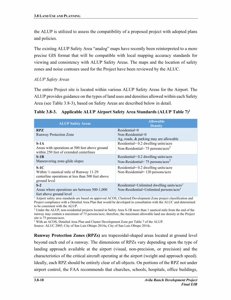
ALUP Safety Areas
The entire Project site is located within various ALUP Safety Areas for the Airport. The ALUP provides guidance on the types of land uses and densities allowed within each Safety Area (see Table 3.8-3), based on Safety Areas are described below in detail.
Table 3.8-3. Applicable ALUP Airport Safety Area Standards (ALUP Table 7)1
ALUP Safety Areas Allowable Density
RPZ Runway Protection Zone
Residential=0 Non-Residential=0 Ag, roads, & parking may are allowable
S-1A Areas with operations at 500 feet above ground within 250 feet of extended centerlines
Residential= 0.2 dwelling units/acre Non-Residential= 75 persons/acre2
S-1B Maneuvering zone-glide slopes
Residential= 0.2 dwelling units/acre Non-Residential= 75 persons/acre2
S-1C Within ½ nautical mile of Runway 11-29 centerline operations at less than 500 feet above ground level
Residential= 0.2 dwelling units/acre Non-Residential= 120 persons/acre
S-2 Areas where operations are between 500-1,000 feet above ground level
Residential=Unlimited dwelling units/acre3 Non-Residential=Unlimited persons/acre3
1 Airport safety area standards are based on approved ACOS, Clustered Development Zone project classification and Project compliance with a Detailed Area Plan that would be developed in consultation with the ALUC and determined to be consistent with the ALUP. 2 Under the ALUP, non-residential projects located in Safety Area S-1B more than 1 nautical mile from the end of the runway may contain a maximum of 75 persons/acre; therefore, the maximum allowable land use density at the Project site is 75 persons/acre. 3 With an ACOS, Detailed Area Plan and Cluster Development Zone per Table 7 of the ALUP. Source: ALUC 2005; City of San Luis Obispo 2014a; City of San Luis Obispo 2014c.
Runway Protection Zones (RPZs) are trapezoidal-shaped areas located at ground level beyond each end of a runway. The dimensions of RPZs vary depending upon the type of landing approach available at the airport (visual, non-precision, or precision) and the characteristics of the critical aircraft operating at the airport (weight and approach speed). Ideally, each RPZ should be entirely clear of all objects. On portions of the RPZ not under airport control, the FAA recommends that churches, schools, hospitals, office buildings,

3.8 LAND USE AND PLANNING
Avila Ranch Development Project 3.8-11 Final EIR
shopping centers, and other places of public assembly such as recreational facilities, as well as fuel storage facilities, be prohibited. Vehicle parking is considered acceptable only on the outer edges of RPZs (outside the extended object-free area).
ALUP Safety Area S-1 is the area within the vicinity of which aircraft operate frequently or in conditions of reduced visibility at altitudes less than 500 feet above ground level (AGL). Safety Area S-1 is further divided into the following zones, each with different hazards and development limitations.
ALUP Safety Area S-1A includes the area within 500 feet on either side of the extended runway centerline and within 500 feet of an existing or planned runway end. This is an area with frequent or low visibility aircraft operations at less than 500 feet above ground level, which are located within 250 feet of extended runway centerlines and within 3,000 feet of a runway end. No part of the Project site is within this Area.
ALUP Safety Area S-1B is comprised of those portions of Safety Area S-1 which are not included in Safety Area S-1A, but are within probable gliding distance for aircraft on expected approach or departure courses. This Safety Area also includes State-defined sideline Safety Areas, inner turning zones and outer safety zones for both Runway 11-29 and Runway 7-25. Aviation safety hazards to be particularly considered in this area include mechanical failures, fuel exhaustion, deviation from glideslope or minimum descent altitude (MDA) during instrument flight rules (IFR) operations (due to pilot error or equipment malfunction), loss of control during short approach procedures, stall/spin incidents during engine-out maneuvers in multi-engine aircraft, loss of control during “go around” or missed approach procedures, and midair collisions. Approximately 34.9 acres of the Project site is within this area, which would be comprised of the Neighborhood Park, Town Center, and the backyards of a number of R-1 low density residential units, and up to seven R-3 townhome units in the northwest corner of ALUP Safety Area S-1B.
Airport Safety Area S-1C is comprised of those portions of Safety Area S-1 which are not included in Safety Areas S-1A or S-1B, but are adjacent to Runway 11-29 (within 0.5 nautical mile [nm]) frequent or low-visibility aircraft operations at less than 500 feet above ground level. Aviation safety hazards to be considered in this area include mechanical failures, deviation from localized runaway approach during IFR operations (due to pilot error or equipment malfunction), stall/spin incidents during engine-out maneuvers in multi-engine aircraft, loss of control

3.8 LAND USE AND PLANNING
3.8-12 Avila Ranch Development Project Final EIR
during “go around” or missed approach procedures, and loss of visual references by aircraft performing circle-to-land procedures. The outer border of Safety Area S-1C is rectangular in shape. Approximately 7.6 acres of the Project site are in this area. Open Space is proposed for this Safety Area.
ALUP Safety Area S-2 represents the area within the vicinity of the Project where aircrafts operate frequently or in conditions of reduced visibility at altitudes between 501 and 1,000 feet above ground level (AGL). Aviation safety hazards identified in the ALUP include mechanical failures, fuel exhaustion, loss of control during turns from downwind to base legs or from base to final legs of the traffic pattern, stall/spin incidents during engine‐out maneuvers in twin engine aircraft, and midair collisions. Because aircraft in Safety Area S‐2 are at greater altitude and are less densely concentrated than in other portions of the ALUPA, the overall level of aviation safety risk is considered to be lower than that in Area S‐1 or the RPZs (ALUC 2005). Approximately 107.5 acres of the Project site are within Safety Area S-2, which would be comprised of all but seven of the 720 residential units in the Project.
ALUP Safety Policies
The ALUC reviews proposed projects within the ALUPA to determine consistency with the ALUP. A proposed general plan, general plan amendment, specific plan, specific plan amendment, zoning ordinance, zoning ordinance amendment, building regulation modification, or individual development proposal may be determined to be inconsistent with the ALUP by the ALUC. For the proposed Project, the key issue relates to residential densities, with the ALUP generally requiring progressively lower allowable residential land use densities, and related reductions in future population exposed to potential hazards, the closer a property lies to the end of a runway (refer to Table 3.8-3). Key policies used to review a project or local action for consistency with the ALUP include:
Policy S-1: Would permit or lack sufficient provisions to prohibit structures and other obstacles within the RPZs for any runway at the Airport, as depicted in ALUP Figure 4.
Policy S-2: Would permit or fail to adequately prohibit any future residential or nonresidential development or redevelopment which would create, within the site to be developed or redeveloped, a density greater than specified in ALUP Table 7 or any mixed-use development or redevelopment which would create, within the

3.8 LAND USE AND PLANNING
Avila Ranch Development Project 3.8-13 Final EIR
site to be developed or redeveloped, densities greater than illustrated in ALUP Table 7.
Policy S-3: Would permit or fail to adequately prohibit any future development project which specifies, entails, or would result in a greater building coverage than permitted by ALUP Table 7.
Policy S-4: Would permit or fail to adequately prohibit high intensity land uses or special land use functions (impaired egress uses or unusually hazardous uses), except that, when conditions specified by ALUP Table 7 for density adjustments have been determined to be met by the ALUC, high intensity land and/or special function uses may be allowed in ALUP Safety Area S-2.
Developmental Intensity
As it pertains to ALUP Policy S-4, increases in allowable residential and non-residential densities may be allowed with inclusion of an approved Airport Compatible Open Space Plan (ACOS), Clustered Development Zone (CDZ) and/or Detailed Area Plan, as described below. Table 7 of the ALUP specifies permissible development intensities in the respective safety zones under different planning conditions.
• Airport Compatible Open Space Plan
On July 21, 2004, the ALUC voted to amend the ALUP with inclusion of the City’s ACOS. The ACOS establishes open spaces in the areas around the Airport that can serve as reserve spaces (for aircraft emergency situations). By maintaining reserve spaces that keep certain land adjacent to the Airport free and clear from obstruction or from buildings and uses where people congregate, the ACOS improves airport safety while allowing for more intense development of urban areas. The areas identified as reserve space in the ACOS include land that is close to the Airport, in line with the main Airport runway, or along an over-flight area where aircraft typically operate at lower altitudes. Identification of these areas in the ACOS plan adds Airport safety to the list of reasons why these lands should not be developed (City of San Luis Obispo & County of San Luis Obispo 2013). The Project includes an approximately 120 foot by 1,200 foot ACOS Reserve Area on the north side of Buckley Road between the east Project boundary and Jesperson Road.

3.8 LAND USE AND PLANNING
3.8-14 Avila Ranch Development Project Final EIR
• Clustered Development Zone
A CDZ may include any part or all of the area encompassed by an ACOS, and the geographic extent of each CDZ will be determined and specified by the responsible local agency. In order to be approved by the ALUC, an ACOS that proposes to establish one or more CDZs must be provided for the establishment, protection, and maintenance in perpetuity of the following percentages of each proposed CDZ as Reserve Space:
o in ALUP Airport Safety Area S-1C ...35% of the gross area of the CDZ o in ALUP Airport Safety Area S-2 ......25% of the gross area of the CDZ
• Detailed Area Plan
The AASP is the Detailed Area Plan. The Project’s Development Plan also qualifies as a Detailed Area Plan. The development of a Detailed Area Plan is a process which affords local agencies an opportunity to work with the ALUC in planning for development that meets local needs with respect to density while, by virtue of an increased level of specificity, protects the public against undue aviation safety hazards.
Applicability of ALUP to Project Site
As the Project site lies within the ALUPA, the Project is subject to the ALUP’s restrictions in building height, allowable uses, and population densities in the interest of safety and airport hazards. The Project site is located within ALUP Safety Areas S-1B, S-1C, and S-2 and the 55 A-weighted decibels (dBA) CNEL and 65 dB single-event noise contours. The ALUP designates approximately 34.9 acres of the Project site in Safety Area S-1B, 7.6 acres of the site in Safety Area S-1C, and 107.5 acres of the site in Safety Area S-2 (refer to Table 3.8-4). These regulations limit residential development on the Project site within the 42.5 acres that are currently mapped under the ALUP as being within Safety Areas S-1B and S-1C to a total of 9 units (0.2 units/ acre), with the remaining roughly 107.5 acres of the site that fall within Safety Area 2 unrestricted in terms of residential densities (refer to Tables 3.8-3 and 3.8-4).

3.8 LAND USE AND PLANNING
Avila Ranch Development Project 3.8-15 Final EIR
Table 3.8-4. Acreage of Project Site within ALUP Airport Safety Areas
ALUP: Airport Safety Areas Project Site Designation
(acres) RPZ Runway Protection Zone 0 S-1A Areas with operations at 500 feet above ground within 250 feet of extended centerlines 0 S-1B Maneuvering zone-glide slopes 34.9 S-1C Within ½ nautical mile of operations at less than 500 feet above ground level 7.6 S-2 Areas where operations are between 500-1,000 feet above ground level 107.5
Source: ALUC 2005.
The ALUP 55 dB CNEL and 65 dB single-event noise contours intersect the northeastern corner of the Project site. Both of the noise contours are wholly contained within the S-1C Safety Area and/or are outside of the URL. As addressed in Section 3.9, Noise, the ALUP contains advisory restrictions on land use and development related to noise levels generated by Airport operations, including with exposures of 55 dBA CNEL.
3.8.3.4 Local
City of San Luis Obispo General Plan
In accordance with California state law, the City adopted a General Plan to guide development within the City. The General Plan expresses the City’s development goals, state public policy in regards to future land uses, provides the basis for local government decision making, and informs citizens and decision-makers of policies pertaining to development. The purpose of the General Plan is to identify the appropriate location of land uses, as well as basic design and function of circulation, open space, and infrastructure policies, as well as public service needs. The City’s General Plan consists of eight state-mandated and optional elements: Land Use and Circulation Element (2014); Housing Element (2015); Noise Element (1996); Safety Element (2014); Conservation and Open Space Element (2006); Parks and Recreation Element (2001); and, Water and Wastewater Element (2014). Project consistency with specific policies from the General Plan are analyzed below in Section 3.8.4, Consistency with Plans and Policies and within specific EIR sections.

3.8 LAND USE AND PLANNING
3.8-16 Avila Ranch Development Project Final EIR
Land Use and Circulation Element
The LUCE was adopted on December 9, 2014 and is the land use planning document that governs existing and future land uses and establishes goals, policies, and development criteria for land uses and circulation in the City. The LUCE identifies the Project site as Special Focus Area, SP-4, with the following requirements:
Policy 8.1.6 Purpose. The Project area will be developed as primarily a residential neighborhood development with supporting neighborhood commercial, park, recreation facilities, and open space/resource protection. Within the Project, emphasis should be on providing a complete range of housing types and afford abilities. The specific plan for this area should consider and address the following land use and design issues:
a) Provision of a variety of housing types and affordability levels.
b) Modification of the AASP to either exclude this area or designate it as a special planning area within the AASP.
c) Provision of buffers along Buckley Road and along eastern edge of property from adjacent agricultural uses.
d) Provision of open space buffers along northern and western boundaries to separate this development from adjacent service and manufacturing uses.
e) Provision of open space buffers and protections for creek and wildlife corridor that runs through property.
f) Safety and noise parameters described in this General Plan and the purposes of the State Aeronautics Act; or other applicable regulations relative to the San Luis Obispo County Regional Airport.
g) Participation in enhancement to Buckley Road and enhancement of connection of Buckley Road to South Higuera Street.
h) Appropriate internal and external pedestrian, bicycle, and transit connections to the City’s circulation network.
i) Implementation of the City’s Bicycle Transportation Plan including connections to the Bob Jones Trail.
j) Water and wastewater infrastructure needs as detailed in the City’s Water and Wastewater Master Plans. This may include funding and/or construction of a wastewater lift station.
k) Fire protection and impacts to emergency response times.
l) Architectural design that relates to the pastoral character of the area and preserves view of agrarian landscapes.
m) Provision of a neighborhood park.
3.8 LAND USE AND PLANNING
Avila Ranch Development Project 3.8-17 Final EIR
LUCE Chapter 7, Airport Area
Regulations in Chapter 7 of the LUCE, titled Airport Area, apply to all uses, activities, and existing and proposed development on properties within ALUP Safety Areas S-1B, S-1C, and S-2 designated in the ALUP. The LUCE requires that new development and land uses within the RPZs and ALUP Safety Area S-1A shall be consistent with provisions of the ALUP. LUCE policies relating to airport land use are listed below.
7.3. Airport Land Use Plan. Land use density and intensity shall carefully balance noise impacts and the progression in the degree of reduced safety risk further away from the runways, using guidance from the ALUP, State Aeronautics Act, and California Airport Land Use Planning Handbook guidelines. The City shall use the Airport Master Plan forecasts of aviation activity as a reasonably foreseeable projection of ultimate aviation activity sufficient for long-term land use planning purposes. Prospective buyers of property subject to airport influence should be so informed.
7.4. Airport Safety Zones. Density and allowed uses within the Airport Safety Zones shall be consistent with the ALUP unless the City overrides a determination of inconsistency in accordance with Section 21676 and 21676.5 et. seq. of the Public Utilities Code. If the City overrides a determination, all land uses shall be consistent with the State Aeronautics Act and guidance provided in the California Airport Land Use Planning Handbook guidelines, City policies, and noise standards as substantiated by the San Luis Obispo County Airport Master Plan activity forecasts as used for noise planning purposes.
7.5. Airport Noise Compatibility. The City shall use the aircraft noise analysis prepared for the Airport Master Plan EIR as an accurate mapping of the long term noise impact of the airport’s aviation activity that is tied to the ultimate facilities development depicted in the FAA-approved Airport Layout Plan. The City shall use the 60 dB CNEL aircraft noise contour (FAA and State aircraft noise planning standard) as the threshold for new urban residential areas. Interiors of new residential structures shall be constructed to meet a maximum 45 dB CNEL.
7.12. County Airport Land Use Plan. The City shall continue to work with the ALUC to strive to achieve consistency between the ALUP and the City’s General Plan. If consistency cannot be achieved, the City shall preserve and maintain as a plausible alternative its constitutional land use authority to overrule the ALUC with

3.8 LAND USE AND PLANNING
3.8-18 Avila Ranch Development Project Final EIR
regard to adopting General Plan policies that are consistent with the purposes of the California Airport Land Use Planning Handbook, State Aeronautics Act, and State Law. Applicable sections of the Zoning Regulations and Specific Plans shall be amended accordingly.
7.16. Airport Overlay Zone. The City shall create an AOZ to reflect the boundaries of the ALUP within the City limits. The purpose of the AOZs are to codify airport compatibility criteria in areas for which the City may override the ALUP determination to ensure compliance with the requirements of the California State Aeronautics Act (Cal. Pub. Utilities Code, Section 21670, et. seq.), which establishes statewide requirements for airport land use compatibility planning, guidance from the California Airport Land Use Planning Handbook, which is published by the California Department of Transportation Division of Aeronautics to support and amplify the State Aeronautics Act requirements, and other related federal and state requirements relating to airport land use compatibility planning. Implementation of the compatibility policies was intended to be accomplished through the Zoning Regulations.
7.17. Airport Land Use and Zoning Code. The City shall update its Zoning Regulations to address allowable uses and development standards for areas in which the City may override a determination of inconsistency. Zoning Regulations shall be consistent with the requirements of the State Aeronautics Act, use guidance from the Caltrans Airport Handbook, and comply with related state and federal requirements relating to airport land use compatibility. These development standards will include, but are not limited to, intensity and density limitations, identification of prohibited uses, infill development, height limitations, obstructions and other hazards to flight, noise insulation requirements, buyer awareness measures, nonconforming uses, and reconstruction. The process for airport compatibility criteria reviews by the City shall be consistent with these development standards.
LUCE Airport Overlay Zone
Subsequent to adoption of the LUCE, in 2015, the City adopted changes to its Zoning Regulations to implement LUCE Chapter 7, Airport Area policies; particularly GIS based mapping and adoption of AOZs to address aviation safety areas. AOZ dimensions and maximum allowable densities are based on the recommendations made by the ALUC Compatibility Report. This report employed guidelines for established airport safety areas

3.8 LAND USE AND PLANNING
Avila Ranch Development Project 3.8-19 Final EIR
set forth by the Caltrans Airport Handbook, which provides recommendations, based on runway length, for the size and configuration of aviation safety areas. Approximately 5 acres of the Project site lies within AOZ-4, 142 acres lies within AOZ-6, and 3 acres lies outside the AOZs entirely (see Tables 3.8-5 and 3.8-6).
Table 3.8-5. LUCE AOZ Standards
City's Airport Overlay Zones Allowable Densities AOZ-1 Runway Protection Zone
Residential= 0 Non-Residential=0 Ag, roads, & parking may be allowable
AOZ-2 Inner Approach/Departure Zone
Residential=0 Non-Residential= 60-80 persons/acre
AOZ-3 Inner Turning Zone
Residential= Infill to average of surrounding density Non-Residential= 100-150 persons/acre
AO-4 Outer Approach/ Departure Zone
Residential=Infill to average of surrounding density Non-Residential=150-200 persons/acre
AOZ-5 Sideline Zone
Residential=Infill to average of surrounding Non-Residential= 100-150 persons/acre
AOZ-6 Traffic Pattern Zone
No Limitations
Outside AOZ No Limitations Source: ALUC 2014. Table 3.8-6. Acreage of Project Site within LUCE-defined AOZ
City's Airport Overlay Zone Project Site Acreage Project Site Designation AOZ-1 Runway Protection Zone 0
--
AOZ-2 Inner Approach/Departure Zone 0
--
AOZ-3 Inner Turning Zone 0
--
AO-4 Outer Approach/ Departure Zone 5
Open space, Neighborhood Park.
AOZ-5 Sideline Zone 0
--
AOZ-6 Traffic Pattern Zone
142
Low density residential, medium density residential, medium-high density residential, high density residential, open space, pocket park, neighborhood park, town center.
Outside AOZ 3 Medium density residential, pocket park. Source: (ALUC 2014).
Compatibility
Compatibility issues between City goals and policies in the General Plan and the ALUP have persisted over the course of many years, leading to differences in priorities and planning approaches for lands surrounding the Airport. When the City last updated its Land Use Element in 1994, the ALUC was then preparing an update of the ALUP. When the

3.8 LAND USE AND PLANNING
3.8-20 Avila Ranch Development Project Final EIR
City completed an update of its Safety Element in 2000, the ALUP update was still underway, inhibiting coordination between the City and ALUC. The current ALUP update is scheduled to be completed in 2017. As discussed in Sections 3.8.2.2 and 3.8.3 above, differing land use priorities, staggered land use planning document update schedules, and differences in mapping techniques and interpretation of the Caltrans Airport Handbook have led to different conclusions and recommendations for restrictions on land use development surrounding the Airport, including the Project site.
As discussed above, the ALUP was originally adopted in 1973 and was last updated in 2005. Analysis performed as part of the LUCE update indicated that the mapping of the ALUP Safety Areas appears to be inaccurate and as such, that these areas may not reflect guidance set forth in the Caltrans Airport Handbook.
The LUCE Update EIR and associated technical studies provided detailed analysis of safety hazards and noise concerns associated with the current and future operation of the Airport in relation to planned growth in the southern areas of the City. The Airport Land Use Compatibility Report findings were used to inform the City of potential airport safety hazards presented by the LUCE Update, and provided recommendations to support airport policy amendments that would increase compatibility between the LUCE and the ALUP, if the ALUP update also incorporated these same policies.
As discussed above, for the Project site, the LUCE, associated technical studies, and subsequent updates to the City’s Zoning Regulations found that only the eastern five acres of the site would fall within AOZ-4, Outer Approach/ Departure Zone, a potentially restrictive AOZ that would effectively limit density in this five-acre area to that equivalent to the average of surrounding uses. The majority of the Project site (142 acres) was found to fall within AOZ-6, Traffic Pattern Zone, or lie outside of any AOZ (3 acres), with no associated restrictions in residential density. In contrast, the ALUP identifies 57 acres in the northern and eastern reaches of the site as falling within ALUP Safety Areas S-1B and S-1C, which severely restrict residential densities to 0.2 units/ acre, with the remaining roughly 93 acres of the site that fall within ALUP Safety Area S-2, which is not restricted for residential development. This difference between City and ALUP findings is due to a fundamental difference in policy, and, as a result, the agencies use different criteria to determine the boundaries of the safety zones.
In its findings for approval of the LUCE and to override the ALUP, the City noted that the ALUP is outdated and appear to contain inaccuracies. The City also noted that such changes in information and technology necessitate periodic updates to plans such as the

3.8 LAND USE AND PLANNING
Avila Ranch Development Project 3.8-21 Final EIR
ALUP to reflect such new information. The need for changes increase the importance of the City working with the ALUC to ensure that the ALUP reflects the Airport Master Plan and the physical changes to the airport runways that have been constructed in recent years (City of San Luis Obispo 2014c).
In summary, the main issue concerning the compatibility between the LUCE and ALUP is the inconsistency of allowable densities located within the ALUP Safety Areas and those set forth in City AOZs. For the Project site, the City’s adopted land use designations and AOZs do not restrict residential density over 145 acres of the Project site, while the ALUP severely limits densities over 57 acres of the site. As noted above, the City has found that such restrictions are not warranted given actual operations of the Airport and the ALUC has acknowledged potential inaccuracies in mapping in the 2005 ALUP. These issues as they apply to the Project site are discussed further under Impacts LU-1 and LU-2 in Section 3.8.5.3 below.
City of San Luis Obispo’s Right to Overrule
In a circumstance where the ALUC makes a determination of inconsistency with the ALUP for a proposed project, the City can overrule the ALUC determination of inconsistency as allowed under Section 21676.5 et. seq. of the Public Utilities Code. As directed by the LUCE, should an overrule action be taken, development shall be consistent with LUCE policies and standards that reflect direction in the State Aeronautics Act, FAA regulations concerning obstructions and notification, and guidance provided in the Caltrans Airport Handbook. As stated in City Resolution 10585, in December 2014, the City Council exercised the power to overrule the ALUC determination of inconsistency of the then-proposed LUCE land use designations for land surrounding the Airport with the ALUP, and found that land use designations set forth under the LUCE were consistent with sound airport planning (City of San Luis Obispo 2014c).
While the City overruled the ALUC’s determination that the 2014 LUCE Update was inconsistent with the ALUP, the action to overrule relates specifically to the LUCE Update, and not to Specific Plan areas designed by the LUCE only. Therefore, potential development projects that fall under the jurisdiction of the ALUP, including allowable development on the Project site, would still be subject to ALUP consistency review by the ALUC and potential for any follow on review and potential action by the City.

3.8 LAND USE AND PLANNING
3.8-22 Avila Ranch Development Project Final EIR
Conservation and Open Space Element
The City’s adopted Conservation and Open Space (COS) Element contains goals and policies pertaining to the preservation of open space and agricultural areas, protection of scenic corridors, and the conservation of creeks and other natural resources. For the Project site, issues of particular concern include protection and restoration of Tank Farm Creek, as well as preservation of agricultural resources.
Housing Element
The City’s Housing Element includes goals, strategies, policies, and detailed programs to secure adequate and affordable housing to its citizens. It serves as a community guide and decision-making document to meet housing needs, preserve and enhance neighborhoods, and increase affordable housing opportunities for very-low, low, and moderate income persons and households. The Housing Element describes the City’s demographic, economic, and housing stock to assist in addressing projected housing needs.
Additional General Plan Elements
The proposed Project must also be consistent with the policies of several other General Plan Elements, particularly policies associated with noise impacts addressed in the Noise Element, site access and the adequacy of bicycle facilities addressed in the Circulation Element, and establishment of neighborhood parks discussed in the Parks and Recreation Element (refer to Table 3.8-7).
City of San Luis Obispo Zoning Regulations
San Luis Obispo’s Zoning Regulations define 15 zoning districts in three categories: residential, non‐residential, and overlay. The residential zones include: low‐density residential, medium‐density residential, medium‐high‐density residential, and high‐density residential. The non‐residential zones include: conservation/open space, office, public facility, neighborhood commercial, retail commercial, community commercial, Downtown commercial, tourist commercial, service commercial, manufacturing, and business-park. The overlay zones include: planned development, specific plan, historic, mixed‐use, and special considerations.
Airport Area Specific Plan
The Project site is within the AASP’s 1,500-acre planning area. The AASP is a land use program with policies, goals, guidelines, and infrastructure financing strategies for future

3.8 LAND USE AND PLANNING
Avila Ranch Development Project 3.8-23 Final EIR
development that ensure land use compatibility within the AASP planning area. The Project site was annexed into the City in 2008 after the adoption of the AASP in 2005, and was designated as Business Park, which is the same designation the County applied to the site prior to its annexation to the City. The AASP was most recently amended in 2014 to address changes to the Chevron Tank Farm property to the northeast of the Project site. As part of this Project, the AASP would be amended to implement the 2014 LUCE, and to accommodate the proposed Project. The amendment would also ensure the Project’s consistency with the AASP’s programs, policies, and guidelines. As with other specific plans in the City, the amended AASP would provide the development regulations equivalent to zoning. While the AASP covers an area greater in size than that of the Project, the amendments to the AASP are intended to specifically cover the proposed Project site. The proposed AASP amendment does not include land use changes other than those for the Project, except to the extent that the existing AASP fee schedule will need to be modified, and this could affect parts of the AASP outside the Project site.
City of San Luis Obispo Community Design Guidelines
The City’s Community Design Guidelines, revised in 2010, includes numerous principles related to site planning, building design, street orientation, and creek side development. Section 3.1, Aesthetics and Visual Resources, analyzes the proposed Project’s physical impacts related to principles outlined in these guidelines.
3.8.4 Consistency with Plans and Policies
This section summarizes relevant adopted goals and policies, and evaluates the proposed Project’s consistency with guidelines and requirements established therein. The following discussion of General Plan policies and preliminary determinations regarding Project consistency with these policies is presented for informational purposes. Section 15125(d) of the State CEQA Guidelines requires that an EIR “shall discuss any inconsistencies between the proposed Project and applicable general plans and regional plans.” In this case, the adopted plans most relevant to the proposed Project include the City’s General Plan and the ALUC’s ALUP. Table 3.8-7 discusses preliminary determination of the Project’s consistency with applicable policies from the General Plan and standards from the ALUP. Detailed analysis of the consistency of the Project with the ALUP is provided in Appendix N. Where potential policy inconsistencies are identified, to the extent feasible, the EIR identifies mitigation measures to improve Project consistency with these policies. The City will make the final decision regarding Project consistency.

3.8 LAND USE AND PLANNING
3.8-24 Avila Ranch Development Project Final EIR
General Plan Consistency
Table 3.8-7 summarizes the proposed Project’s consistency with policies established under the City’s General Plan. For reference, the Applicant also prepared a separate General Plan conformity analysis containing additional policies, located in Appendix N.
Table 3.8-7. General Plan Policy Consistency Summary
Policy/Goal Summary Consistency Finding Discussion
Land Use Element 1.4 – Urban Edges Character
The City shall maintain a clear boundary between San Luis Obispo's urban development and surrounding open land. Development just inside the boundary shall provide measures to avoid a stark-appearing edge between buildings in the City and adjacent open land.
Consistent Although development of the site would result in creation of residential development at the edge of the City’s urban area, the Project would include a 300-foot wide open space buffer, including a landscaped berm, along Buckley Road to soften the transition from urban to rural area. The urban edges for the Project are outside of the URL and will be preserved with conservation easements. Along the Buckley Road frontage, the western third of the Project is buffered by Tank Farm Creek. The middle third between Tank Farm Creek and Jesperson will be buffered by landscaping and a terra-formed sound wall berm and fence, and the eastern third will have substantial open space inside the URL.
1.5 – Jobs/Housing Relationship
The gap between housing demand (due to more jobs and college enrollment) and supply should not increase.
Consistent The proposed Project would create 720 residential dwelling units and would help maintain the current jobs/housing ratio of 1.5. Currently, the City is job rich and lacks adequate housing for the local labor force. The Project would help to meet this housing demand.
1.7.1 – Urban Reserve
The City shall maintain an urban reserve line containing the area around the city where urban development might occur
Consistent Development of all residential and commercial units exists within the URL as envisioned by this policy.

3.8 LAND USE AND PLANNING
Avila Ranch Development Project 3.8-25 Final EIR
Table 3.8-7. General Plan Policy Consistency Summary (Continued)
Policy/Goal Summary Consistency Finding Discussion
1.8.1 – Open Space Protection
Within the City's planning area and outside the urban reserve line, undeveloped land should be kept open. Prime agricultural land, productive agricultural land, and potentially productive agricultural land should be protected for farming. Scenic lands, sensitive wildlife habitat, and undeveloped prime agricultural land should be permanently protected as open space.
Consistent with Mitigation
In accordance with the LUCE EIR, the Applicant must dedicate open space land or, in lieu of fees for newly annexed land at a ratio of no less than 1:1. The Project will dedicate 15 acres of open space within in the URL and would be required to provide for permanent conservation of approximately 71 acres of offsite agricultural lands.
1.8.3 – Commercial uses in the Greenbelt
The City shall not allow commercial development within the greenbelt area unless it is clearly incidental to and supportive of agriculture or other open space uses.
Consistent The Project is within the URL and therefore supportive of agriculture and open space use as a greenbelt.
1.8.5 – Building Design and Siting
All new buildings and structures should be subordinate to and in harmony with the surrounding landscape. The City should encourage County adoption of regulations prohibiting new structures on ridge lines or in other visually prominent or environmentally sensitive locations, and allowing transfer of development rights from one parcel to another in order to facilitate this policy.
Consistent The proposed Project site design provides setbacks for the riparian corridors and the Buckley frontage. Buildings do not back on to these facilities except where necessary for noise mitigation requirements.
1.8.6 – Wildlife Habitat
The City shall ensure that continuous wildlife habitat- including corridors free of human disruption are preserved, and, where necessary, created.
Consistent with Mitigation
Project development would result in elimination of portions of the Tank Farm Creek riparian corridor. However, the proposed Project would include overall restoration of Tank Farm Creek’s riparian corridor subject to further design review by the City. The realignment of Tank Farm Creek will re-connect the wildlife corridors from the East Fork of San Luis Creek to the Chevron open space. The area will be re-vegetated where necessary to provide added foraging habitat

3.8 LAND USE AND PLANNING
3.8-26 Avila Ranch Development Project Final EIR
Table 3.8-7. General Plan Policy Consistency Summary (Continued)
Policy/Goal Summary Consistency Finding Discussion
and protection. MM BIO-2a would require creek setbacks of at least 35 feet to protect riparian habitat and preserve the existing corridor. See Section 3.4, Biological Resources, and Section 3.7, Hydrology and Water Quality.
1.9.1 – Agricultural Protection
The City shall support preservation of economically viable agricultural operations and land within the urban reserve and city limits. The City should provide for the continuation of farming through steps such as provision of appropriate general plan designations and zoning.
Consistent with Mitigation
The City has considered the viability of agricultural operations on the Project site through past planning efforts, such as the LUCE Update and AASP. Though the site has historically been cultivated with barley, wheat, safflower, and beans, agricultural productivity is limited by availability of irrigation water and soil type. By acknowledging the Project site’s limited productivity, the LUCE Update and AASP designated the area for urban development with requirements for conservation and replacement of prime agricultural land. Accordingly, the Project would result in the conversion of 81.2 acres of prime agricultural land to non-agricultural use (78.2 acres within the Project site and 3 acres within the Buckley Road Extension site). As required under LUCE Policy 8.6.3, the Applicant must dedicate open space land or, pay in lieu of fees for acquisition of agricultural land at a ratio of no less than 1:1. The Project will dedicate 10 acres of prime soils onsite for agricultural operations and would be required to conserve an additional 71 acres of farmland for offsite agricultural conservation. See Section 3.2, Agricultural Resources for additional information regarding the viability of agriculture onsite.

3.8 LAND USE AND PLANNING
Avila Ranch Development Project 3.8-27 Final EIR
Table 3.8-7. General Plan Policy Consistency Summary (Continued)
Policy/Goal Summary Consistency Finding Discussion
1.9.2 – Prime Agricultural Land
The City may allow development on prime agricultural land if the development contributes to the protection of agricultural land in the urban reserve or greenbelt.
Consistent with Mitigation
The City has considered the protection of agricultural resources on the Project site through past planning efforts, such as the LUCE Update and AASP. Though the site has historically been cultivated with barley, wheat, safflower, and beans, agricultural productivity is limited by availability of irrigation water and soil type. By acknowledging the Project site’s limited productivity, the LUCE Update and AASP designated the area for urban development with requirements for conservation and replacement of prime agricultural land. Accordingly, the Project would result in the conversion of 78.2 acres of prime agricultural land to non-agricultural use (78.2 acres within the Project site and 3 acres within the Buckley Road Extension property). As required under LUCE Policy 8.6.3, the Applicant must dedicate open space land or, pay in lieu of fees for acquisition of agricultural land at a ratio of no less than 1:1. The Project will dedicate 10 acres of prime soils onsite and would be required to conserve an additional 71 acres of farmland for offsite agricultural conservation. See Section 3.2, Agricultural Resources for additional information regarding agricultural land protection in the urban reserve/greenbelt.
1.10.2 – Means of Protection
The City shall require that open space is to be preserved either by dedication of permanent easements or transfer of fee ownership to the City, the County, or a responsible,
Consistent The urban edges for the Project are outside of the URL and will be preserved with conservation easements or restrictive covenants, which will be held by conservation groups.

3.8 LAND USE AND PLANNING
3.8-28 Avila Ranch Development Project Final EIR
Table 3.8-7. General Plan Policy Consistency Summary (Continued)
Policy/Goal Summary Consistency Finding Discussion
nonprofit conservation organization.
1.10.3 – Public Access
Areas preserved for open space should include public trail access, controlled to protect the natural resources, to assure reasonable security and privacy of dwellings, and to allow continuing agricultural operations. Public access through production agricultural land will not be considered, unless the owner agrees.
Consistent The Project’s land use plan and circulation plan includes public streets that side onto the Tank Farm Creek open space, and connect to a multi-use trail that provides public access along the entire reach of Tank Farm Creek. See Policy 3.3.2.
1.10.4 – Design Standards
The City shall require cluster development to: A. Be screened from public views by land forms or vegetation, but not at the expense of habitat. If the visually screened locations contain sensitive habitats or unique resources as defined in the Conservation and Open Space Element, development should be avoided in those areas and instead designed to cluster in the form of vernacular farm building complexes, to blend into the traditional agricultural working landscape. B. Be located on other than prime agricultural/and be situated to allow continued agricultural use. C. Prohibit building sites and roads within stream corridors and other wetlands, on ridge lines, rock outcrops, or visually prominent or steep hillsides, or other sensitive habitats or unique resources as defined in the Conservation and Open Space Element. D. Preserve historic or archaeological resources.
Consistent with Mitigation
The City has considered clustered development to conserve resources on the Project site through past planning efforts, such as the LUCE Update and AASP. Though the site has historically been cultivated with barley, wheat, safflower, and beans, agricultural productivity is limited by availability of irrigation water and soil type. By acknowledging the Project site’s limited productivity, the LUCE Update and AASP designated the area for urban development with requirements for clustering development to preserve open spaces and agricultural resources. The Project would result in the conversion of 78.2 acres of prime agricultural land to non-agricultural use (78.2 acres within the Project site and 3 acres within the Buckley Road Extension property). As required under LUCE Policy 8.6.3, the Applicant must dedicate open space land or, pay in lieu of fees for acquisition of agricultural land at a ratio of no less than 1:1. The Project will dedicate 10 acres of prime soils onsite and would be required to conserve an additional 71 acres of

3.8 LAND USE AND PLANNING
Avila Ranch Development Project 3.8-29 Final EIR
Table 3.8-7. General Plan Policy Consistency Summary (Continued)
Policy/Goal Summary Consistency Finding Discussion
farmland for offsite agricultural conservation. See Section 3.2, Agricultural Resources. Additionally, the Tank Farm Creek riparian corridor will contain wetland setbacks per amended AASP Program 6.3.7 and Policy 3.3.3 (see Section 3.4, Biological Resources). There are no known historic or archeological resources on the Project site (see Section 3.5, Cultural Resources).
1.13.8 A – Open Space
The City shall require that each annexation help secure permanent protection for areas designated open space, and for the habitat types and wildlife corridors within the annexation area that are identified in the COS Element.
Consistent The Project is already located within the City and does not include an annexation. The Project would include provision of 55.3 acres of open space, including lands along Tank Farm Creek.
1.13.10 – Solid Waste Capacity
The City shall require that adequate solid waste disposal capacity exists before granting any discretionary land use approval which would increase solid waste generation.
Consistent There is adequate capacity at the Cold Canyon Landfill to support the Project. See Section 3.13, Utilities.
2.3.7 – Natural Features
The City shall require residential developments to preserve and incorporate as amenities natural site features, such as land forms, views, creeks, wetlands, wildlife habitats, wildlife corridors, and plants.
Consistent with Mitigation
Project development would result in substantial changes to onsite natural drainage patterns and elimination of portions of the Tank Farm Creek riparian corridor. In addition, areas of Project development would occur within designation City creek setbacks. However, the proposed Project would include overall restoration and enhancement of Tank Farm Creek’s riparian corridor subject to further design review by the City. See Section 3.4, Biological Resources, and Section 3.7, Hydrology and Water Quality.
2.3.8 – Parking The City shall discourage the development of large parking lots and require parking lots be screened from street views. In
Consistent The Project includes a 75-space parking lot to accommodate Town Center parking. Design guidelines would ensure proper

3.8 LAND USE AND PLANNING
3.8-30 Avila Ranch Development Project Final EIR
Table 3.8-7. General Plan Policy Consistency Summary (Continued)
Policy/Goal Summary Consistency Finding Discussion
general, parking should not be located between buildings and public streets.
screening of residential parking places (see Project Appendix F).
2.3.11 – Residential Project Objectives
Residential projects should provide: -Privacy, for occupants and neighbors of the project. -Pleasant views from and toward the project. -Security and safety. -Noise and visual separation from adjacent roads and commercial uses. -Buffers from hazardous materials transport routes, as recommended by the City Fire Department.
Consistent The Project would comply with providing Residential Project Objectives via adherence and implementation of policies and design guidelines. Refer to Section 3.1, Aesthetics and Visual Resources, 3.9, Noise, and 3.7, Hazards and Hazardous Materials.
3.3.1 – New or expanded areas of Neighborhood Commercial use
The City shall provide for new or expanded areas of neighborhood commercial uses that: A. Are created within, or extended into, nonresidential areas adjacent to residential neighborhoods. B. Provide uses to serve nearby residents, not the whole City. C. Have access from arterial streets, and not increase traffic on residential streets. D. Have safe and pleasant pedestrian access from the surrounding service area, as well as good internal circulation. E. Are designed to be pedestrian-oriented, and architecturally compatible with the adjacent neighborhoods being served.
Consistent The Project would include 15,000 sf of neighborhood commercial in the form of a “Town Center”. The Town Center may serve as a place for a convenience store, community gathering place, a transit hub, and a location for occasional community events and gatherings. Community members would be able to access the Town Center via community and regional roadways, bicycle paths, pedestrian linkages, and transit.
6.6.1 – Creek and Wetlands Management Objectives
Maintain and restore natural conditions and habitats; minimize flooding damage; recognize sections of creeks which are in largely natural areas and manage for maximum ecological value.
Potentially Consistent with Mitigation
Project development would result in substantial changes to onsite natural drainage patterns and elimination of portions of the Tank Farm creek riparian corridor. In addition, areas of Project development would

3.8 LAND USE AND PLANNING
Avila Ranch Development Project 3.8-31 Final EIR
Table 3.8-7. General Plan Policy Consistency Summary (Continued)
Policy/Goal Summary Consistency Finding Discussion
occur within designated City creek setbacks. However, the Project would include overall restoration and enhancement of Tank Farm Creek’s riparian corridor subject to further design review by the City. Refer to Section 3.4, Biological Resources and Section 3.7, Hydrology and Water Quality.
6.6.3 – Amenities and Access
New development adjacent to creeks must respect the natural environment and incorporate the natural features as project amenities, providing doing so does not diminish natural values.
Consistent with Mitigation
Project development would result in substantial changes to onsite natural drainage patterns and elimination of portions of the Tank Farm Creek riparian corridor. In addition, areas of Project development would occur within designated City creek setbacks. However, the proposed Project would include overall restoration and enhancement of Tank Farm Creek’s riparian corridor subject to further design review by the City. The proposed Project would include a Class I pedestrian/bicycle path along the west bank of Tank Farm Creek that connects to the Town Center and other roadway linkages.
6.7 – Creeks and Flooding Programs
Requires drainage improvements and other Project enhancements to reduce potential flooding of creek channels. *Maybe not applicable with undeveloped parcel.
Consistent with Mitigation
The proposed Project would include major drainage improvements and substantial alteration to the existing Tank Farm Creek floodplain and associated changes to on- and offsite drainage patterns. Refer to Section 3.4, Biological Resources, and Section 3.7, Hydrology and Water Quality.
7.3 – Airport Land Use Plan
Land use density and intensity shall carefully balance noise impacts and the progression in the degree of reduced safety risk further away from the runways.
Consistent Project land use and development densities would be consistent with the 55 dB CNEL noise contour and City AOZ designed to reduce safety risks, with development located from 3,500 feet to over 6,000

3.8 LAND USE AND PLANNING
3.8-32 Avila Ranch Development Project Final EIR
Table 3.8-7. General Plan Policy Consistency Summary (Continued)
Policy/Goal Summary Consistency Finding Discussion
feet from the end of the airport runway.
7.4 – Airport Overlay Zones
Density and allowed uses within the ALUP Safety Areas shall be consistent with the ALUP unless the City overrides a determination of inconsistency where all land uses are consistent with the AOZs.
Consistent Project land use densities would be consistent with the LUCE policies, ALUP policies and regulations and City AOZs, as well
7.5 – Airport Noise Compatibility
The City shall use the 60 dB CNEL aircraft noise contour (FAA and State aircraft noise planning standard) as the threshold for new urban residential areas. Interiors of new residential structures shall be constructed to meet a maximum 45 dB CNEL.
Consistent Project development would be located outside of the 60 dB noise contour and interior noise levels would be reduced to less than 45 dB through application of standard California Building Code requirements. See Section 3.9, Noise.
8.1.6 – SP-4, Avila Ranch Specific Plan Area
This area will be developed as primarily a residential neighborhood development with supporting neighborhood commercial, park, recreation facilities, and open space/resource protection. Within the Project, emphasis should be on providing a complete range of housing types and afford abilities.
Consistent The Project would consist primarily of new residential neighborhoods with a variety of housing types and affordability levels along with supporting open space, park and commercial areas. See Section 3.10, Population and Housing.
Conservation and Open Space Element
2.2.1 – Atmospheric Change
City actions shall seek to minimize undesirable climate changes and deterioration of the atmosphere’s protective functions that result from the release of carbon dioxide and other substances.
Consistent with Mitigation
Development of 720 new residential units near the southern edge of the City would result in substantial GHG generation during construction and operation. Although bicycle and pedestrian amenities and local-serving commercial uses would be provided, the site’s distance from Downtown and lack of high frequency transit routes would present challenges for minimization of long-term GHG generation. See Section 3.3, Air Quality and Greenhouse Gas Emissions.

3.8 LAND USE AND PLANNING
Avila Ranch Development Project 3.8-33 Final EIR
Table 3.8-7. General Plan Policy Consistency Summary (Continued)
Policy/Goal Summary Consistency Finding Discussion
2.2.4 – Promote walking, biking, and use of public transit use to reduce dependency on motor vehicles
City actions shall seek to reduce dependency on gasoline- or diesel-powered motor vehicles and to encourage walking, biking, and public transit use.
Consistent Although the Project would provide bicycle and pedestrian facilities and new development would be located in close proximity to commercial and industrial employment centers in the City’s southern reaches, The site’s distance from Downtown and lack of high frequency transit routes may present challenges for minimization of long-term GHG generation. However, the Project would provide bicycle and pedestrian facilities, as well as transit improvements that would promote the use of alternative methods of transportation, therefore reducing future GHG emissions. Further, new development would be located in close proximity to commercial and industrial employment centers within the City’s southern reaches, promoting walkability and reducing motor vehicle use.
9.2.1 – Views to and from public places, including scenic roadways
Preserve and improve views of important scenic resources from public places...including streets and roads.
Consistent Project development would substantially alter and potentially adversely impact views along Buckley Road. However, inclusion of a 300-foot wide open space buffer and landscape berm would help minimize visual intrusion. This change would not be significant and would therefore be consistent with City policy. See Section 3.1, Aesthetics and Visual Resources.
9.3.6 – View blockage along scenic highways
Determine that view blockage along scenic roadways is a significant impact.
Consistent Although Buckley Road is identified as a scenic corridor, inclusion of a 300-foot wide open space buffer along Buckley Road would prevent view blockage. See Section 3.1, Aesthetics and Visual Resources.

3.8 LAND USE AND PLANNING
3.8-34 Avila Ranch Development Project Final EIR
Table 3.8-7. General Plan Policy Consistency Summary (Continued)
Policy/Goal Summary Consistency Finding Discussion
4.3.4 – Use of Energy Efficient, Renewable Energy Resources 4.3.6 – Energy Efficiency and Green Building in New Development 4.6.8 – Energy Efficient Project Design
Promotes use of cost effective, renewable, non-depleting energy sources, wherever possible, in new construction projects; encourages energy-efficient LEED-certified “green buildings”; emphasize use of solar exposure and shading.
Consistent The Project is proposed to be compliant with the U.S. Green Building Council’s Leadership in Energy and Environmental Design for Neighborhood Development (“LEED-ND”) “Silver” certification and San Luis Obispo County’s Green Build “Emerald” certification rating.
5.5.8 – Recycling Facilities in New Development
Requires facilities in new developments to accommodate and encourage recycling.
Consistent The Project would create additional sources for generation of solid waste. Project Design Guidelines would ensure recycling facilities are provided.
7.3.1 – Protect Listed Species
City will comply with State and Federal requirements for listed species; City will protect listed species through its actions on…development applications.
Potentially Consistent with Mitigation
The Project would potentially impact several listed species through habitat development and/or habitat degradation, but would be subject to feasible mitigation. See Section 3.4 Biological Resources.
7.3.3 – Wildlife Habitat and Corridors
Continuous wildlife habitat, including corridors free of human disruption, shall be preserved and where necessary, created by interconnecting open spaces, wildlife habitat, and corridors.
Consistent with Mitigation
The Project would convert 81.2 acres of open agricultural (78.2 acres within the Project site and 3 acres within the Buckley Road Extension property), which currently permit relatively free wildlife passage to urban development. Development of the Project would inhibit or eliminate such passage. While the Project would dedicate 55.3 acres as open space, including the Tank Farm Creek riparian corridor, the Tank Farm creek corridor would be relatively narrow, particularly through the central reaches of the site (e.g., 125 feet wide). This corridor would be bordered by adjacent homes and roads, traversed by a Class I paved bicycle path, and crossed by two bike bridges, with associated noise, light, and disturbances. The relatively

3.8 LAND USE AND PLANNING
Avila Ranch Development Project 3.8-35 Final EIR
Table 3.8-7. General Plan Policy Consistency Summary (Continued)
Policy/Goal Summary Consistency Finding Discussion
narrow width of this corridor and proximity of development would potentially interfere with wildlife passage and limit its value as a wildlife corridor. Mitigation proposed in Section 3.4, Biological Resources would address this policy.
7.7.6 – Replace Invasive, Non-Native Vegetation with Native Vegetation
The City and private development will protect and enhance habitat by removing invasive, non-native vegetation and by replanting it with native California plant species.
Consistent The Project would include habitat restoration efforts that would involve removal of non-native species and planting of native vegetation. See Section 3.4, Biological Resources.
7.7.7 – Preserve Ecotones
Ensure that “ecotones,” or natural transitions along the edges of different habitat types, are preserved and enhanced.
Consistent The Project site currently supports limited ecotones as it primarily consists of open agricultural fields, which border native habitats along Tank Farm Creek. While the Project includes general proposals for habitat restoration along the creek corridor, it is unclear if these would include creation of different habitat types to meet the intent of this policy. Mitigation proposed in Section 3.4, Biological Resources, would address this policy.
7.7.8 – Protect Wildlife Corridors
Condition development permits in accordance with applicable mitigation measures to ensure that important corridors for wildlife movement and dispersal are protected.
Consistent While the Project would dedicate 55.3 acres as open space, including the Tank Farm Creek riparian corridor, the Tank Farm Creek corridor would be relatively narrow, particularly through the central reaches of the site (e.g., 125 feet wide). This corridor would be bordered by adjacent homes and roads, traversed by a Class I paved bicycle path, and crossed by two bike bridges, with associated noise, light, and disturbances. The relatively narrow width of this corridor and proximity of development would potentially interfere with wildlife passage and limit its value as a wildlife corridor. Mitigation proposed in Section

3.8 LAND USE AND PLANNING
3.8-36 Avila Ranch Development Project Final EIR
Table 3.8-7. General Plan Policy Consistency Summary (Continued)
Policy/Goal Summary Consistency Finding Discussion
3.4, Biological Resources, would address this policy.
7.7.9 – Creek Setbacks
Maintain creek setbacks to include appropriate separation from the physical top of bank, the appropriate floodway, native riparian plants, or wildlife habitat and space for paths.
Consistent with Mitigation
Project development including the proposed Class I bicycle path, fill associated with development pads, and new roads would intrude into the minimum required creek setbacks with secondary consequences for protection of habitats, water quality, and wildlife movement. City policy requires a minimum setback of 20 feet from the top of bank or from the edge of the predominant pattern of riparian vegetation, whichever is farther from the creek flow line. Mitigation proposed in Section 3.4, Biological Resources, would address this policy.
8.2.2A – Open Space within the Urban Area
Identifies creek corridors as a valuable resource for dedication as Permanent Open Space.
Consistent The Project would dedicate 55.3 acres as open space, a limited portion of which would include open space along the Tank Farm Creek riparian corridor.
8.2.2D – Open Space within the Urban Area
Identifies undeveloped land not intended for urban uses as a valuable resource for dedication as Permanent Open Space.
Consistent The Project would dedicate 55.3 acres as open space, including the Tank Farm Creek riparian corridor, and 35 acres outside the URL as open space.
8.2.2H – Open Space within the Urban Area
Identifies prime agricultural soils as a valuable resource for dedication as Permanent Open Space.
Potentially Consistent
The Project would dedicate 55.3 acres as open space, including the Tank Farm Creek riparian corridor, and 35 acres outside the URL as open space. There are 14 acres of Prime Farmland, 12 acres of which run along the Buckley Road frontage outside the URL. See Section 3.2, Agricultural Resources.
8.3.2A – Open Space Buffers
Requires buffers between urban development and creek corridors.
Consistent Project development, including the proposed Class I bicycle path, fill associated with building pads and new roads would intrude into the minimum City required creek

3.8 LAND USE AND PLANNING
Avila Ranch Development Project 3.8-37 Final EIR
Table 3.8-7. General Plan Policy Consistency Summary (Continued)
Policy/Goal Summary Consistency Finding Discussion
setbacks, with secondary consequences for protection of habitats, water quality, and wildlife movements. Mitigation required in Section 3.4, Biological Resources, would address this policy.
8.6.3 – Required Mitigation
Farmland requires mitigation to permanently protect an equal area of equal quality.
Consistent In accordance with the AASP EIR and LUCE Update EIR, the Applicant must dedicate open space land or in lieu of fees for newly annexed land at a ratio no less than 1:1. The Project would dedicate 71 acres as conserved agricultural lands. See Section 3.2, Agricultural Resources.
8.7.2 – Enhance and Restore Open Space
Enhance and restore open space by removing invasive, non-native species, re-establishing native riparian vegetation, eliminating sources of water pollutants, removing trash and debris contaminants, and securing alternative funding.
Consistent The Project would include habitat restoration efforts that would involve significant removal of non-native species and planting of native vegetation. See Section 3.4, Biological Resources.
10.2.2 H – Ahwahnee Water Principles
Encourages principles/policies for reduced water demand, runoff, and flooding.
Consistent While the Project would create an additional long-term demand on City water supplies, the Project would include state of the art water conservation measures that would meet LEED-ND Silver and San Luis Obispo Emerald Green standards, including use of recycled water and onsite flood water retention. See Section 3.13, Utilities.
Housing Element
3.2 – Goal 2: Affordability
Requires that affordable housing production shall be accommodated to meet the City’s new housing construction objectives.
Consistent The Project would result in 720 residential units, 105 units of which qualify as affordable. Project-proposed housing would accommodate residents that live and work in the City as well as residents of very low-income levels.
3.2 – Goal 4: Mixed Income Housing
Preserve and accommodate existing and new mixed-income
Consistent The Project would result in 720 residential units, 105 units of
3.8 LAND USE AND PLANNING
3.8-38 Avila Ranch Development Project Final EIR
Table 3.8-7. General Plan Policy Consistency Summary (Continued)
Policy/Goal Summary Consistency Finding Discussion
neighborhoods and seek to prevent neighborhoods or housing types that are segregated by economic status.
which qualify as affordable. Project-proposed housing would accommodate residents that live and work in the City as well as residents of very low-income levels.
3.2 – Goal 6: Housing Production
Outlines strategies for the City to plan for new housing to meet a full range of community housing needs.
Consistent The Project would result in 720 residential units, 105 units of which qualify as affordable. Project proposed housing would accommodate residents that live and work in the City as well as residents of very-low income levels.
3.2 – Goal 10: Local Preference
Maximize affordable housing opportunities for those who work in the City of San Luis Obispo.
Consistent The Project would result in 720 residential units, 105 units of which qualify as affordable. Project-proposed housing would accommodate residents that live and work in the City.
3.2 – Goal 11: Suitability
Develop and retain housing on sites that are suitable for that purpose.
Consistent The Project site is considered a Special Plan Area established in the LUCE to accommodate new housing.
Noise Element
1.4 – New Transportation Noise Sources
Noise created by new transportation noise sources shall be mitigated to not exceed City-specified indoor and outdoor maximum noise exposure levels.
Consistent The Project would not increase transportation noise beyond acceptable levels. See Section 3.9, Noise.
1.3 – New Development Design and Transportation Noise Sources
New noise-sensitive development shall be located and designed to meet the maximum outdoor and indoor noise exposure to city specified levels.
Consistent Project exterior and interior noise levels would remain acceptable. See Section 3.9, Noise.
1.10 – Existing and Cumulative Impacts
The City shall consider mitigation where existing or cumulative increases in noise levels significantly impact noise-sensitive land uses, including rerouting traffic, noise barriers, reducing traffic speed, retrofitting buildings, and exaction of fees.
Consistent While the Project would contribute to short-term construction noise impacts and long-term operational noise impacts, the Project would not significantly contribute to existing and cumulative noise impacts. See Section 3.9, Noise.

3.8 LAND USE AND PLANNING
Avila Ranch Development Project 3.8-39 Final EIR
Table 3.8-7. General Plan Policy Consistency Summary (Continued)
Policy/Goal Summary Consistency Finding Discussion
Safety Element
2.1 – Flood Hazard Avoidance and Reduction
C. No new building or fill should encroach beyond, or extend over, the top-of-bank of any creek. E. Within new development areas, such as the potential expansion areas shown in Figure 2 of the Land Use Element, substantial displacement of flood waters should be avoided by: 1. Keeping a substantial amount of flood-prone land in the vicinity as open space; 2. Enlarging man-made bottlenecks, such as culverts, which contribute to flood waters backing up from them; 3. Accommodating in such places uses which have relatively low ratios of building coverage to site area, for which shallow flooding of parking and landscape areas would cause minimum damage. 4. Requiring new buildings to be constructed above the 100-year flood level. F. Creek alterations shall be considered only if there is no practical alternative, consistent with the Conservation and Open Space Element. G. Development close to creeks shall be designed to avoid damage due to future creek bank erosion. Property owners shall be responsible for protecting their developments from damage caused by future bank loss due to flood flows.
Consistent with Mitigation
The proposed Project would include substantial alteration to the existing Tank Farm Creek floodplain and associated changes to on- and offsite drainage patterns. Refer to Section 3.4, Biological Resources, and Section 3.7, Hydrology and Water Quality.
3.0 – Adequate Fire Service
Development shall be approved only when adequate fire suppression services and facilities are available or will be made available concurrent with development, considering the
Consistent The Project site is marginally outside the acceptable 4-minute response time for fire protection services. However, installation of the Project’s proposed Interim Fire Station would

3.8 LAND USE AND PLANNING
3.8-40 Avila Ranch Development Project Final EIR
Table 3.8-7. General Plan Policy Consistency Summary (Continued)
Policy/Goal Summary Consistency Finding Discussion
setting, type, intensity, and form of the proposed development.
provide coverage to the Project site, until the City’s fifth fire station is constructed and operational, ensuring that the Project is consistent with City policy for adequate fire service. See Section 3.11, Public Services.
5.2 – Minimizing Hazardous Materials
People’s exposure to hazardous substances should be minimized.
Consistent with Mitigation
The Project would implement standard good housekeeping measures, best management practices (BMPs), site maintenance, and security precautions, as well as compliance with standards and regulations. See Section 3.6, Hazards and Hazardous Materials.
7.0 – Policy S: Airport Land Use Plan
Development should be permitted only if it is consistent with the San Luis Obispo County Airport ALUP.
Potentially Consistent
The Project is in conformance with the ALUP, Handbook, AOZ standards, and LUCE airport safety policies, and further evaluated below in Impacts LU 1 and LU 2.
9.3 A – Response Performance Standards
The City will evaluate fire-flow capacities and identify deficiencies through testing and modeling of the water system. For identified deficiencies, the Utilities Department will propose remedies to meet recommended service levels based on Insurance Service Organization ratings and other objective criteria.
Consistent The Project will provide adequate water flow per adopted City standards. See Section 3.13, Utilities, and Impact LU-3 below.
Water and Wastewater Management Element (WWME)
2.1.7 – Annexation Criteria
Allows annexation of areas outside City limits if they are infill areas with access to existing City wastewater service.
Consistent The Project would be located within City limits and the City’s URL with access to existing City services. Wastewater disposal is evaluated in Section 3.13, Utilities.
B 2.2.2 – Service Capacity
The City's wastewater collection system and Water Reclamation Facility shall support population and related
Potentially Consistent
There is adequate capacity at the City’s Water Resource Recovery Facility (WRRF) to accommodate dry-weather wastewater flows generated by

3.8 LAND USE AND PLANNING
Avila Ranch Development Project 3.8-41 Final EIR
Table 3.8-7. General Plan Policy Consistency Summary (Continued)
Policy/Goal Summary Consistency Finding Discussion
service demands consistent with the General Plan.
the Project; however, under wet-weather conditions, peak wastewater flows may exceed the WRRF capacity. See Section 3.13, Utilities, and Impact LU-3 below.
B 2.2.3 – Wastewater Service for New Development
New development will only be permitted if adequate capacity is available within the wastewater collection system and/or Water Reclamation Facility.
Potentially Consistent
There is adequate capacity at the City’s WRRF to accommodate dry-weather wastewater flows generated by the Project; however, under wet-weather conditions, peak wastewater flows may exceed the WRRF capacity. See Section 3.13, Utilities, and Impact LU-3 below.
Circulation Element
3.1.7 – Transit Service Access
New development should be designed to facilitate access to transit service.
Potentially Consistent
The Project would include installation of bus stops and facilitation of the extension of bus service the Project site. However, the site is outside of areas that receive high frequency transit service. Issue evaluated in Section 3.12, Transportation and Traffic.
4.1.4 – New Development
The City shall require that new development provide bikeways, secure bicycle storage, parking facilities and showers consistent with City plans and development standards. When evaluating transportation impacts, the City shall use a Multimodal Level of Service analysis.
Potentially Inconsistent Consistent with Mitigation
The Project would provide dedicated bikeways and would be required to provide bicycle parking per City of San Luis Obispo Municipal Code Section 17.16.060, which mandates that bicycle parking be equal to 15 percent of vehicle parking provided. However, an important gap in the planed regional Class II bicycle lane along west bound Buckley Road could cause impacts to cyclists and inconsistencies with the BTP. See Section 3.12, Transportation and Traffic.
5.1.2 – Sidewalks and Paths
The City should complete a continuous pedestrian network connecting residential areas with major activity centers as well as trails leading into City and County open spaces.
Consistent with Mitigation
The Project would include fully developed pedestrian facilities within the Project site; however, access to the shopping center to the north would be along roadways that may not be fully developed

3.8 LAND USE AND PLANNING
3.8-42 Avila Ranch Development Project Final EIR
Table 3.8-7. General Plan Policy Consistency Summary (Continued)
Policy/Goal Summary Consistency Finding Discussion
with pedestrian amenities. This issue would be addressed with required mitigation. See Section 3.12, Transportation and Traffic.
5.1.4 – Pedestrian Access
New or renovated commercial and government public buildings shall provide convenient pedestrian access from nearby sidewalks and pedestrian paths, separate from driveways and vehicle entrances.
Consistent Sidewalks and pedestrian pathways separate from driveways and/or vehicle entrances are provided to the proposed Town Center. See Section 3.12, Transportation and Traffic.
15.1.2 – Development along Scenic Routes
The City will preserve and improve views of important scenic resources from streets and roads. Development along scenic roadways should not block views or detract from the quality of views.
Consistent While the Project would change visual character of the area, the Project would preserve important views through inclusion of a 300-foot setback for new development from Buckley Road. See Section 3.1, Aesthetics and Visual Resources.
Parks and Recreation Element
3.13.1 – Parks System
The City shall develop and maintain a park system at a rate of 10 acres of parkland per 1,000 residents. Five acres shall be dedicated as a neighborhood park. The remaining five acres required under the 10 acres per 1,000 residents in the residential annexation policy may be located anywhere within the City’s park system as deemed appropriate.
Consistent A 9.80-acre neighborhood park would be located to the east of the Town Center, and within 0.5 mile from most proposed residential neighborhoods. Additionally, seven mini-parks and one pocket park would be created on irregular-shaped tracts of land near residential areas to serve the local population. These parks would serve residential areas farther from the neighborhood park. Community gardens would be located on 1.30 acres of the planned open space east of the neighborhood park.
3.15 – Neighborhood Parks
- San Luis Obispo residents shall have access to a neighborhood park within 0.5 to 1.0 mile walking distance of their residence. -All residential annexation areas shall provide developed neighborhood parks at the rate
Consistent A 9.80-acre neighborhood park would be located to the east of the Town Center, and within 0.5 mile from most proposed residential neighborhoods. Additionally, seven mini-parks and one pocket park would be created on irregular-shaped

3.8 LAND USE AND PLANNING
Avila Ranch Development Project 3.8-43 Final EIR
Table 3.8-7. General Plan Policy Consistency Summary (Continued)
Policy/Goal Summary Consistency Finding Discussion
of five acres per 1,000 residents. -In neighborhoods where existing parks do not adequately serve residents, mini-parks may be considered.
tracks of land near residential areas to serve the local population. These parks would serve residential areas farther from the neighborhood park. Community gardens would be located on 1.30 acres of the planned open space east of the neighborhood park.
Sources: City of San Luis Obispo 1996, 2006, 2014b, 2015.
ALUP Consistency
Table 3.8-8 summarizes Project consistency with the ALUP. ALUP consistency is also further discussed in Impact LU-2.
Table 3.8-8. ALUP Consistency Summary
Project Component Consistency Finding Discussion 55 dB CNEL Aviation Noise Contour Open Space Consistent Dedicated open space area is an acceptable use under the
ALUP 55 dB CNEL Aviation Noise Contour. Issue evaluated in Section 3.9, Noise. Proposed uses in the 55 dB CNEL contour are open space, agriculture and community gardens.
Safety Area S-1B Neighborhood Park Consistent Park space is an acceptable land use under ALUP Safety
Area S-1B. Residential Consistent Up to seven residential units are permitted in the 35-acre
S-1B area. These will be clustered in the northwest portion of the zone. This is consistent.
Town Center Consistent Retail and commercial uses are allowed under ALUP Safety Area S-1B.
Open Space Consistent Dedicated open space area and agricultural operations are acceptable land uses under ALUP Safety Area S-1B.
Safety Area S-1C Open Space Consistent Dedicated open space area is an acceptable land use
under ALUP Safety Area S-1C. Safety Area S-2 Residential Uses Consistent There are 713 residential units proposed within this
Safety Area; however, there are no density restrictions within Safety Area S-2. See Impact LU-2 for further discussion.
Park and Open Space Consistent Dedicated open space area is an acceptable land use under ALUP Safety Area S-2.

3.8 LAND USE AND PLANNING
3.8-44 Avila Ranch Development Project Final EIR
AASP Consistency
Table 3.8-9 summarizes Project consistency with the AASP. AASP consistency is also further discussed in Impact LU-2.
Table 3.8-9. AASP Consistency Summary
Policy/Goal Consistency Finding Discussion
Policy 3.2.1 Riparian Vegetation. Establish healthy, continuous riparian vegetation along (1) East Branch of San Luis Obispo Creek from Broad Street to Santa Fe Road, (2) Acacia Creek from the northern planning area boundary to the confluence with East Branch of San Luis Obispo Creek, (3) Orcutt Creek from the planning area northern boundary to its confluence with Acacia Creek, and (4) Tank Farm Creek from the planning area’s northern boundary to its southern boundary.
Potentially Consistent
A continuous riparian corridor would be established under the Project from the northeastern boundary to the southwestern corner, establishing a consistent riparian zone. However, the proposed limited setbacks of development from the riparian corridor would be inconstant with City policy. Increased setbacks and development reconfiguration would ensure consistency. .
Policy 3.2.4 Wetlands and Buffer Areas. Designate for open space use wetlands and their associated buffer areas.
Consistent The Project includes open space buffers between wetland areas and proposed development areas, primarily on either side of Tank Farm Creek and in the southeast region of the Project site. However, Project development would also result in the permanent loss of habitats within the Project site including protected wetlands and riparian areas associated with Tank Farm Creek. These impacts would be mitigated by MM AG-1a, MM HYD-4a, MM HYD-4b, MM BIO-1a, MM BIO-1b, MM BIO-2a through -2j, and MM BIO-6 implementing a Biological Mitigation Plan, Best Management Practices, and Environmental Monitor to oversee, replace, restore, create, and protect, among other actions, existing and future wetlands associated with the Project site and maintain high-quality wildlife habitat. Coordination with the Regional Water Quality Control Board (RWQCB), City Fire Department (SLOFD), and CDFW is included.
Policy 3.2.5 Restoring Marginal or Degraded Wetlands. When reviewing plans to restore marginal or degraded wetlands, require (1) techniques for isolation, stabilizing, or removing petroleum contamination of soil and groundwater that minimize disturbance of existing wetland and other surface resource values, (2) configuration of the ground surface to retain
Consistent Please refer to Policy 3.2.4 discussion above.

3.8 LAND USE AND PLANNING
Avila Ranch Development Project 3.8-45 Final EIR
Table 3.8-9. AASP Consistency Summary (Continued)
Policy/Goal Consistency Finding Discussion
wetland characteristics, (3) removal of invasive, non-native plants, (4) introduction of native plants, (5) methods approved by the RWQCB, and the SLOFD and (6) will not create a significant attraction for large birds in consideration of airport safety.
Policy 3.2.6 Expansion of Wetlands. Where suitable buffers can be provided, expand wetlands into areas within the wetlands complex that are conducive to wetlands, but that do not initially meet the definition of wetlands. However, any expansion or changes to wetlands must take into account the potential increase in airport safety hazards as a result of bird strikes.
Consistent Please refer to Policy 3.2.4 discussion above.
Policy 3.2.8 Professional Direction of Wetland Work. Assure that all wetlands restoration, enhancement, and creation will be under the direction of qualified professionals. Seek the cooperation of trustee agencies, such as the California Department of Fish and Wildlife (CDFW), and obtain any necessary approvals from these agencies.
Consistent Please refer to Policy 3.2.4 discussion above.
Policy 3.2.9 Design of Detention Areas. Design onsite drainage detention areas within the Airport Area to support wetlands characteristics, so they will be visually attractive elements of the landscape and components in a system of wildlife habitat, in addition to flood control facilities.
Consistent Please refer to Policy 3.2.4 discussion above.
Policy 3.2.10: Recreational Use of Wetlands Complex. Recreational use of the wetlands complex and buffer areas should be limited to non-intrusive observation and study. The type and extent of public access should be restricted in order to maintain high-quality wildlife habitat.
Consistent Please refer to Policy 3.2.4 discussion above.
Policy 3.2.11 Impacts from Run-Off. Minimize the water-quality impacts associated with run-off from rooftops and paved areas, due to contaminants, temperature changes, velocity changes, and sediment by providing dispersed surface drainage across areas with suitable soil and vegetation whenever feasible, instead of
Consistent Please refer to Policy 3.2.4 discussion above.

3.8 LAND USE AND PLANNING
3.8-46 Avila Ranch Development Project Final EIR
Table 3.8-9. AASP Consistency Summary (Continued)
Policy/Goal Consistency Finding Discussion
piped or other concentrated drainage from roofs and paved areas directly to creeks. Policy 3.2.15 Continuous Open Space Corridors. Provide continuous open space corridors linking open space resources within the Airport Area to resources outside of the Airport Area.
Consistent Please refer to Policy 3.2.4 discussion above.
Policy 3.2.16 Continuous Wetlands. Development in the Airport Area should not isolate or further fragment wetlands, uplands or their associated habitat areas.
Partially Consistent with Mitigation
Wetland and open space areas are primarily retained along Tank Farm Creek and created in the northeastern and southern regions of the Project site. Wetlands may be affected by the proposed Jespersen Road extension resulting in fragmentation of the existing wetland. MM BIO-2B, Biological Mitigation Plan, would mitigate the Congdon Tarplant and impacts to isolated wetlands by requiring a Bio Mitigation Plan which requires habitat replacement. Impacts and proposed mitigation measures for wetlands are detailed further in Section 3.4, Biological Resources.
Policy 3.2.18 Mitigate Loss of Ag and Open Space Land. To mitigate the loss of agricultural and open land in the Airport Area, development shall help protect agricultural and open space lands to the south and east by securing protected areas at least equal to the area of new development, where on-site protection is not available.
Partially Consistent with Mitigation
The Project would result in the conversion of 71 acres of prime farmland and is therefore subject to mitigation under Policy 1.9.2. Proposed mitigation measure MM AG-1 would satisfy the criteria of Policy 1.9.2, therefore making the Project consistent with this policy after mitigation. However, implementation of MM AG-1 would not fully mitigate such impacts since the lost agricultural land could not be replaced or recreated. Further discussion of these impacts and their determination can be found under the discussion of Impact AG-1 in Section 3.2, Agricultural Resources.
Policy 3.2.20 Acquire Land South of Airport. Utilize locally-generated acquisition funding, as well as outside grant support, to acquire fee or easement interest in lands south of the airport in the following order of priority: Buckley Road Area. Agricultural lands on
either side of Buckley Road between Vachell Lane and Broad Street should receive the highest priority in conservation
Partially Consistent
Please refer to Policy 3.2.18 discussion above. Acquisition of agricultural lands south of the airport would be permitted under proposed mitigation.

3.8 LAND USE AND PLANNING
Avila Ranch Development Project 3.8-47 Final EIR
Table 3.8-9. AASP Consistency Summary (Continued)
Policy/Goal Consistency Finding Discussion
funding. There is ongoing, incremental conversion of lands from agriculture to other uses, as well as ongoing small-scale subdivision of rural properties. There are relatively few large properties in this area. Easements to secure development rights and maintain scenic character would be the primary focus of this effort, and easement acquisition is the preferred strategy.
Other Lands. Areas such as the ranches and woodland areas south of the Airport may also be targeted for fee or easement acquisition; however, these areas are not considered as vulnerable to land use changes as the aforementioned areas.
Program 3.3.7. Creek Restoration Standards. The City will work with CDFW and responsible federal agencies to establish standards for grading, stabilization, and revegetation of all creek channels in the Airport Area. The standards will cover plant species, planting densities, and long-term maintenance requirements and responsibilities.
Consistent Please refer to Policy 3.2.4 discussion above.
Goal 4.1.9 Airport Operations. Airport Area land uses and development, including Airport Compatible Open Space (ACOS), should be compatible with the long-term operation of the airport, and enhancing the viability of the airport as a regional transportation facility.
Consistent Due to the location and density allotments designed by the Project, implementation of the Project would be consistent with airport standards for established airport safety areas and noise buffers. Impacts to safety, noise, and hazards are further discussed within Sections 3.6, Hazards and Hazardous Materials, 3.9, Noise, 3.12, Transportation and Traffic.
Policy 4.3.3 Airport Land Use Plan Consistency. Airport Area development must be consistent with the standards and requirements of the ALUP and/or Public Utilities Code Sections 21670-21679.5.
Consistent The Project would be consistent with all ALUP noise contour and safety area policies, as detailed above in Table 3.8-8.
Program 6.3.G Development Review Requirements. In order to mitigate air, noise and traffic impacts associated with development of the AASP, ensure private development participation in the implementation of the plan by requiring the construction of on-street bicycle lanes as part of development
Consistent The Project includes on-street bicycle lanes, off-street paths, bus stops, intersections, and other street and transit facility improvements throughout the Project site consistent with City standards and standards within the AASP. Specific impacts to air, noise, and traffic are further discussed in Sections 3.3, Air Quality and

3.8 LAND USE AND PLANNING
3.8-48 Avila Ranch Development Project Final EIR
Table 3.8-9. AASP Consistency Summary (Continued)
Policy/Goal Consistency Finding Discussion
street frontage improvements, and require development to dedicate and construct off-street paths where their alignments are within private property. Require development adjacent to bus stops to construct turnouts and bus stops (including shelters) conforming to the bus stop standards in SLO Transit’s Short Range Transit Plan. Project may be required to construct intersection and other street improvements in proportion to their development size and location.
Greenhouse Gas Emissions, 3.9, Noise, and 3.12, Transportation and Traffic.
Program 6.3.I Class I and Class II Bicycle Lanes. Class I bicycle paths and Class II bicycle lanes shall be constructed, signed and marked to meet or exceed the minimum standards established by the Caltrans Highway Design Manual and the City of San Luis Obispo design standards. Class I paths should be a minimum of 12 feet in width with 2-foot shoulders, except in hillside areas where grading would cause visual impacts or along creeks where space is limited. Class II bicycle lanes shall be designed in accordance with the City Bicycle Plan and should be 6 to 7 feet in width.
Consistent The Project includes Class I and II bicycle facilities that meet the design standards within the Caltrans Highway Design Manual as well as City standards. Further, with implementation of MM TRANS-11, the Project would be consistent with the City’s Bicycle Transportation Plan (BTP). See Section 3.12, Transportation and Traffic.
Program 6.3.L Transit Facility Requirements. As part of the development review process, the City will require new development to provide for transit facilities along or adjacent to the project frontage.
Consistent Please refer to Program 6.3.G discussion above.
Goal 6.4.3. Improve Buckley Road to arterial standards while maintaining a street character consistent with the area’s rural setting.
Consistent Please refer to Program 6.3.G discussion above.
Standard 6.4.3.1. Buckley Road shall be extended as a two-lane rural arterial from its currently western terminus at Vachell Lane to South Higuera Street. Timing of extension will be based on achieving traffic volumes and conditions that justify the improvements or when the intervening properties between Vachell Lane and South Higuera Street are redeveloped. Setbacks shall be provided on both sides of the road to allow for
Consistent The Project includes extending Buckley Road from the intersection with Vachell Lane west to South Higuera Street, per Standard 6.4.3.1 recommendations. Traffic volume and use impacts of this extension are detailed in Section 3.12, Transportation and Traffic.
3.8 LAND USE AND PLANNING
Avila Ranch Development Project 3.8-49 Final EIR
Table 3.8-9. AASP Consistency Summary (Continued)
Policy/Goal Consistency Finding Discussion
expansion to a four-lane roadway if future traffic volumes and conditions justify additional lanes. Standard 6.4.3.2. Buckley Road shall be design to minimize impact to adjacent creeks and open space where possible. Setbacks shall be provided on both sides of the road to allow for expansion to a four-lane roadway if future traffic volumes and conditions justify additional lanes.
Consistent Setbacks from Tank Farm Creek and preserved wetland areas are included in the Project. Additionally, traffic volume and circulation impacts of the extension are detailed in Section 3.12, Transportation and Traffic.
Standard 6.4.3.3. On the north side of Buckley Road in undeveloped areas, outside of the 20-foot graded shoulder, there shall be a 12-foot wide multi-use path.
Consistent The Project includes a multi-use path on the north side of Buckley Road in undeveloped areas.
Standard 6.4.4.1. Commercial and industrial collectors without center turn lanes shall have a minimum of two 13-foot travel lanes and two 6-foot bicycle lanes. Each side of the road will have 7-foot tree-lined parkways between the curb and a 5-foot wide sidewalk unless an alternative cross section is approved by the Director of Public Works.
Consistent The Project would include parkway, curb, tree, and sidewalk minimums and adherence to standards as approved by the City Department of Public Works.
Policy 7.1.1. Encourage BMPs. The City will encourage Best Management Practices for drainage when reviewing all development proposals. The use of bio-swales for conveying storm water on-site through open channels is particularly encouraged for their efficacy and natural, aesthetic quality.
Consistent Please refer to Policy 3.2.4 discussion above.
Policy 7.1.2. Creek Corridor Enhancement. As part of the development review process for sites that are crossed by one or more creek corridors, the City will require creek corridor enhancement consisting of: • Removal of non-native vegetation. • Removal of obstructions that impede
storm flows and that are detrimental to aquatic species.
• Establish additional riparian vegetation.
Consistent Please refer to Policy 3.2.4 discussion above.

3.8 LAND USE AND PLANNING
3.8-50 Avila Ranch Development Project Final EIR
Table 3.8-9. AASP Consistency Summary (Continued)
Policy/Goal Consistency Finding Discussion
Policy 7.1.3. Offsite Improvements Permissible. When detention requirements cannot be fully met onsite, offsite improvements of creek corridors is permissible, consistent with the requirements of the City’s Waterways Management Plan and Drainage Design Manual.
Consistent Please refer to Policy 3.2.4 discussion above.
Policy 7.1.4. Porous Paving Encouraged. The use of porous paving to facilitate rainwater percolation is encouraged. As a condition of project approval, the City will require parking lots and paved outdoor storage areas, where practical, to use one or more of the following measures to reduce surface water runoff and aid in groundwater recharge: porous paving; ample landscaped areas that receive surface drainage and that are maintained to facilitate percolation; drainage detention basins with soils that facilitate percolation.
Consistent The Project would result in adverse impacts to water quality due to polluted runoff during construction activities, however implementation of MM BIO-2a and MM HYD-2a through -2c would limit these impacts. Further discussion is contained in Impact HYD-2 of Section 3.7, Hydrology and Water Quality.
Policy 7.1.5. Onsite Detention Basins and Creek Corridors. Detention basins will be owned by the subdivider, a property owners’ association, or a major nonresidential parcel owner, and will be maintained by an owners’ association or a special district. Ownership and maintenance of minor waterways will be the same, with a City easement for open space and, where trails occur, public access.
Consistent Please refer to Policy 3.2.4 discussion above.
Policy 7.9.1: Adequate Fire Suppression Services and Facilities. The City shall provide adequate fire suppression services and facilities to the Airport Area, consistent with the Safety Element of the General Plan, by completing area transportation improvements, co-locating City fire services with existing CALFIRE facilities located on Broad Street, and/or establishing a permanent facility within the Airport Area.
Consistent An Interim Fire Station would be implemented by the Project at the intersection of Earthwood Lane and Venture Drive within the Airport Area during Phase 3, and would be subject to the City’s approval and consistent with the General Plan’s Safety Element and San Luis Obispo Fire Department Master Plan (2016). This fire station would remain operational until establishment of the City’s fifth fire station to serve the southern region of the City. Additional discussion of this item is contained within Section 3.11, Public Services.
Policy 7.9.3 Interim Safety Improvements. Until a permanent facility is developed that enables the City to achieve its response travel time objectives, new development in
Consistent Please refer to Policy 7.9.1 discussion above.

3.8 LAND USE AND PLANNING
Avila Ranch Development Project 3.8-51 Final EIR
Table 3.8-9. AASP Consistency Summary (Continued)
Policy/Goal Consistency Finding Discussion
the Airport Area may be required to finance other improvements that will contribute to alleviating current deficiencies, as identified in the San Luis Obispo Fire Department Master Plan (2009). This policy will be implemented on a case by case basis through conditions of approval when project specific fire and life safety impacts are identified. The Avila Ranch Project may provide an interim fire and/or emergency response substation at the intersection of Earthwood Lane and Venture Drive. Such facilities shall be to the satisfaction of the City Fire Chief.
3.8.5 Environmental Impact Analysis
3.8.5.1 Thresholds of Significance
With respect to land use, Appendix G of the CEQA Guidelines states that a project would have a significant impact on the environment if it would:
a) Conflict with any applicable land use plan, policy, or regulation of an agency with jurisdiction over the project (including, but not limited to, the general plan, specific plan, local coastal program, or zoning ordinance) adopted for the purpose of avoiding or mitigating an environmental effect;
b) Physically divide an established community; or,
c) Conflict with any applicable habitat community plan or natural community conservation plan.
3.8.5.2 Impact Assessment Methodology
Information for this analysis was provided by the City of San Luis Obispo General Plan LUCE and Safety Element, AASP, ALUP, and Project site information on file with the City. The Airport Land Use Compatibility Report, prepared by Johnson Aviation in 2014, was consulted for information regarding compatibility with the Airport. Additionally, information for this section was gathered from recent EIRs, such as the LUCE Update EIR and Chevron Tank Farm Remediation and Development Project EIR prepared for the adjacent property.
With regards to threshold ‘a’, the proposed Project’s potential consistency with relevant General Plan policies and programs is evaluated in Section 3.8.4, Consistency with Plans

3.8 LAND USE AND PLANNING
3.8-52 Avila Ranch Development Project Final EIR
and Policies. Associated land use impact analysis is also provided in Impacts LU-1 and LU-2, as well as within individual resource sections of this EIR. Only those elements of the Project that have the potential to conflict with a stated goal, policy, or program are highlighted in this section.
As it pertains to threshold ‘b’ within the thresholds of significance, the Project would not physically divide an established community, based on the lack of residential land uses within the Project site as the site is bordered by existing agricultural and industrial land. Similarly as it pertains to threshold ‘c’, the Project would not conflict with a habitat community plan or natural community plan as none apply to the Project site or immediate vicinity.
The land use consistency analysis considers whether the Project would be consistent with regional and local plans, policies, and regulations applicable to the Project. In accordance with CEQA and the purpose of this EIR, this discussion primarily focuses on those goals and policies that relate to avoiding or mitigating environmental impacts, and an assessment of whether any inconsistency with these standards creates a significant physical impact on the environment. CEQA Guidelines Section 15125(d) requires that an EIR discuss inconsistencies with applicable plans that the decision-makers should address. By law, the project should be consistent with every policy and objective in a planning document. However, a project is considered consistent with the provisions of the identified regional and local plans if it is compatible with and will further the objectives and policies of the plans.
3.8.5.3 Project Impacts and Mitigation Measures
This section discusses the land use impacts associated with the construction and operation of the Project. Land use impacts associated with the Project are summarized in Table 3.8-10.

3.8 LAND USE AND PLANNING
Avila Ranch Development Project 3.8-53 Final EIR
Table 3.8-10. Summary of Project Impacts
Land Use Impacts Mitigation Measures Residual Significance LU-1. Project development would include residential uses located within the LUCE-defined Airport Overlay Zones (AOZs) that would be consistent with AOZ density and use restrictions and that would not interfere with airport operations or create safety impacts under recognized state and federal guidance for airport operations and safety.
None required Less than Significant
LU-2. The proposed Project would include development within ALUP Safety Areas S-1B, S-1C, and S-2; however, the Project would be potentially consistent with the ALUP.
None required Less than Significant
LU-3. The proposed Project would be potentially inconsistent with several adopted City policies in the General Plan designed to protect biological resources and agricultural resources and ensure provision of adequate utilities and public services.
MM AG-1 MM BIO-2a – j
MM PS-2 MM TRANS-2a – f
MM TRANS-4 MM TRANS-11 MM TRANS-12
Significant and Unavoidable but
Mitigable
Impact LU-1 Project residential uses proposed within the LUCE-defined Airport
Overlay Zones (AOZs) would be consistent with AOZ density and use restrictions and would not interfere with airport operations or create safety impacts under recognized state and federal guidance for airport operations and safety (Less than Significant).
Project development would result in construction of 720 new units with an associated increase of 1,649 new residents and a small commercial Town Center with employees and patrons in the vicinity of the approaches to Runway 7-25, crosswind departures from Runway 11-29, departures from Runway 7-25, and within LUCE AOZs.
The Project site is located in LUCE AOZ-4 and -6. Approximately five acres of the 150-acre Project site (3.4 percent) are located in AOZ 4, 142 acres (94.6 percent) are located in the AOZ-6, and three acres (2 percent) are located outside the AOZs altogether. Only AOZ-4 (Outer Approach/ Departure Zone) provides for restrictions on residential density. The portion of the Project site within AOZ-4 would be maintained as open space and no residential units or Neighborhood Commercial space would be located within AOZ-4. All residential units would be located in AOZ-6 or outside the AOZs, both of which have no limitations on development intensity for either residential or non-residential uses (Table 3.8-11).

3.8 LAND USE AND PLANNING
3.8-54 Avila Ranch Development Project Final EIR
Table 3.8-11. Residential Units Proposed within AOZs
City's Airport Overlay Zone in Project Site Allowable Densities
Project Site Designation
(acres)
Proposed Residential
Units in Zone
AOZ-4 Outer Approach/ Departure Zone
Residential = Infill to average of surrounding density Non-Residential = 150-200 persons/acre 5 0
AOZ-6 Traffic Pattern Zone
No Limitations 142 712
Outside AOZ No Limitations 3 8
Source: ALUC 2014.
AOZ-4: No residential units are proposed in AOZ-4. Although no units are proposed within this AOZ, it is permissible for residential units to infill to average surrounding density. This is consistent with the allowable residential density of AOZ-4 within the Project site.
AOZ-6: A total of 712 residential units and the Town Center are proposed in AOZ-6. This is allowable in AOZ-6, which has an unlimited allowable density. This is consistent with the allowable residential and non-residential densities of AOZ-6 within the Project site.
Outside AOZ Limits: A total of 8 residential units proposed outside AOZ boundaries. With no density limitations outside the AOZs, residential units in this area are consistent with the zoning code.
The City’s AOZs are designed to address airport operational safety issues and avoid potential for airport related hazards, consistent with applicable state and federal guidelines and standards. The AOZs address land use densities and development standards within the City, consistent with the City’s local land use authority. The AOZs do not replace or usurp the ALUC’s authority. Rather, due to documented potential inaccuracies with existing ALUP Safety Area maps and differences in policy approach to Airport planning between the City and the ALUC, the AOZs have been applied to areas within the City limits to clarify the accurate extent of safety zones based on the Caltrans Airport Handbook.
The AOZs are proposed for areas within the City and are designed to provide development standards that address airport safety consistent with the City’s local authority. As part of the LUCE Update EIR, the City previously found that development of up to 700 units on the Project site would be consistent with direction in the State Aeronautics Act, the FAA regulations, and guidance provided in the Caltrans Airport Handbook. Proposed Project

3.8 LAND USE AND PLANNING
Avila Ranch Development Project 3.8-55 Final EIR
development location and density is generally consistent with that envisioned under the LUCE and is not anticipated to result in any significant airport related risks or safety hazards risks (refer to Impact HAZ-3). Based on the location, type, and density of development included in the Project, the Project would be consistent with the City’s AOZs, land use compatibility impacts with the LUCE Airport polices, and associated AOZs, and impacts would be less than significant.
Impact LU-2 The proposed Project would include development within ALUP Safety Areas S-1B, S-1C, and S-2; however, the Project would be potentially consistent with the ALUP (Less than Significant).
Project development would result in construction of seven units within ALUP Safety Areas S-1B and no units located in Safety Area S-1C, which would not conflict with allowable density permitted under the ALUP (Table 3.8-12). The majority of proposed Project development (713 units) would fall within Safety Area S-2, which does not restrict residential density and would therefore be consistent with provisions of the ALUP. As stated in ALUP safety policies, each ALUP Safety Area has density restrictions based on the proposed land use. Based on the location and density allotments designed by the Project, implementation of the Project would be consistent with ALUP standards for the current ALUP Safety Areas.
Table 3.8-12. ALUP Airport Safety Area Standards for Residential Densities1
1 Airport safety zone standards are based on Clustered Development Zone project classification and Project compliance with a Detailed Area Plan that would be developed in consultation with ALUC and determined to be consistent with ALUP. 2 Maximum density of residential land is unlimited with approved ACOS, and Clustered Development Zone (CDZ) and Development Area Plan. Source: ALUC 2005.
ALUP Safety Area
Project Site Designation
(approximate acres)
Maximum Land Use Density –
Residential (units/acre)
Maximum Allowable Units in Safety Area on Project site
Proposed Residential Units within
Safety Airport Safety Area
Consistent with ALUP
S-1B 34.9 0.2 7 R-3: 7 Total: 7
Yes
S-1C 7.6 0.2 1.5 Total : 0 Yes
S-2 107.5 unlimited unlimited R-1: 105 R-2: 305 R-3: 178 R-4 : 125 Total: 713
Yes

3.8 LAND USE AND PLANNING
3.8-56 Avila Ranch Development Project Final EIR
ALUP Safety Area S-1B: A total of 7 R-3 residential units are proposed in ALUP Safety Area S-1B. This is consistent with the allowable residential density of ALUP Safety Area S1-B within the Project site.
Not included in the 7 unit total are 16 R-1 lots located on the boundary of ALUP Safety Area S-1B. The Project Design Guidelines include measures to avoid land use impacts associated with ALUP Safety Area S-1B. These measures include a minimum 45-foot rear yard for any R-1 units that back onto the ‘Town Center’ properties due to ALUP Safety Area requirements (see Appendix F). This setback would ensure no R-1 residential structures would be constructed within ALUP Safety Area S-1B.
Also proposed within ALUP Safety Area S-1B, is the 15,000-sf Town Center. The allowable non-residential density within ALUP Safety Area S-1B is 75 people/acre. With a total of 34.9 acres of the Project within ALUP Safety Area S-1B, up to 2,617 people would be allowed within ALUP Safety Area S-1B at any given time. Increased density of people within this ALUP Safety Area S-1B would most likely result from people utilizing the Neighborhood Commercial area for either goods or services or from residents utilizing the Neighborhood Park for recreation. Adjacent to the Town Center is the proposed parking lot which provides 75 parking spaces. Capacity (persons/per acre) of ALUP Safety Area S-1B could theoretically be reached assuming the full utilization of the parking lot, coupled civilian occupation of the Town Center area for shopping and work purposes, and residents recreating at the park. With such occupation, it would still be highly unlikely that there would be an exceedance of 2,617 persons in ALUP Safety Area S-1B at any given time.
ALUP Safety Area S-1C: No residential units are proposed in ALUP Safety Area S-1C. This is consistent with the allowable residential density of ALUP Safety Area S-1C within the Project site.
ALUP Safety Area S-2: A total of 713 residential units are proposed in ALUP Safety Area S-2. This is within the allowable density of unlimited units and is consistent with the allowable residential density of ALUP Safety Area S-2 within the Project site.
The Project is potentially consistent with the 2005 ALUP and the City’s AOZs, as described in Impact LU-1. As noted in Section 3.6, Hazards and Hazardous Materials, it is also consistent with Caltrans Airport Land Use Planning Handbook’s safety and noise

3.8 LAND USE AND PLANNING
Avila Ranch Development Project 3.8-57 Final EIR
standards. The reasons for this the discrepancy in approach to safety zone mapping appear largely related to the use of different criteria to determine the extent of safety zones and policy differences.
Additionally, the Project involves a Development Plan, includes a Reservation Area for emergency landings, and clusters development in conformance with the ALUP; therefore it qualifies as a Detailed Area Plan and a Clustered Development Zone project and will be reviewed as such under the ALUP.
The ALUC, during a hearing held on December 21, 2016, determined that the Project, as well as the Mitigated Project Alternative, were in conformance with the ALUP (ALUC 2016).The ALUC will review the Project for consistency with ALUP Airport Safety Areas and determine the Project’s consistency with the ALUP. If the ALUC finds that the Project is inconsistent with the ALUP, the City has the authority to exercise an override action of the ALUC under California Public Utilities Code Section 21676.5. The LUCE Update EIR concluded that any potential impacts could be reduced to a less than significant level with the implementation of the existing and proposed LUCE policies.
In conclusion, the Project would be consistent with the LUCE AOZs, which the City has found represents the actual extent of airport-related safety hazard zones consistent with direction in the State Aeronautics Act, the FAA regulations, guidance provided in the Handbook, and the ALUP; therefore, no resultant substantial physical airport-related safety hazards would occur as result of Project implementation, consistent with ALUP policies. While the Project would still be subject to review by the ALUC for consistency with the ALUP, based on the analysis provided above and substantial evidence in the record provided by the LUCE Update EIR and 2014 Airport Land Use Compatibility Report, airport land use planning impacts to future residents and commercial Town Center employees or patrons would be less than significant.
Impact LU-3 The proposed Project would potentially be inconsistent with several adopted City General Plan policies designed to protect biological and agricultural resources and ensure provision of adequate utilities and public services (Significant and Unavoidable but Mitigable).
Consistent with the scope and purpose of this EIR, this discussion primarily focuses on those goals and policies that relate to avoiding or mitigating environmental impacts, and an assessment of whether any inconsistency with these standards creates a significant physical impact on the environment. Discussion of each applicable General Plan policy is

3.8 LAND USE AND PLANNING
3.8-58 Avila Ranch Development Project Final EIR
provided in Table 3.8-7 in Section 3.8.4, Consistency with Plans and Policies. After a review for consistency, it is found that the Project is potentially inconsistent with several policies designed to protect agricultural resources and biological resources and ensure provision of adequate public services as further summarized below.
Agricultural Resources
Policy 1.8.1, Open Space Protection, states that prime agricultural land, productive agricultural land, and potentially productive agricultural land shall be protected for farming. To the contrary, Policy 1.9.2, Prime Agricultural Land, allows development on prime agricultural land if the development contributes to the protection of agricultural land within the City URL. Implementation of Mitigation Measure AG-1a, as required by COS Policy 8.6.3 (C) and AASP Policy 3.2.18, would require that the Applicant establish an offsite agricultural conservation easement or pay in-lieu fees to a designated fund dedicated to acquiring and preserving agricultural land. The Project would result in the conversion of 71 acres of prime farmland and is therefore subject to mitigation under Policy 1.9.2. Proposed mitigation measure Mitigation Measure AG-1 would satisfy the criteria of Policy 1.9.2, therefore making the Project consistent with this policy after mitigation. However, implementation of Mitigation Measure AG-1 would not fully mitigate such impacts since the lost agricultural land could not be replaced or recreated.
Further discussion of these impacts and their determination can be found under the discussion of Impact AG-1 in Section 3.2, Agricultural Resources. With the implementation of Mitigation Measure AG-1 addressed under Impact AG-1, impacts associated with the policies addressing conversion of prime farmland soils to nonagricultural uses would be significant and unavoidable but mitigable.
Biological Resources
The proposed Project would include several design elements that would be built in close proximity to the riparian habitat and wildlife corridor along Tank Farm Creek, potentially impacting sensitive habitats and disrupting wildlife movement due to construction activities and future disturbances for increased noise, activities, and lighting, etc. In particular, fill slopes along up to 2,000 feet of Tank Farm Creek would intrude to areas within 20 feet of the creek bank and potentially within the riparian canopy. Similarly, over 2,800 feet of the proposed paved Tank Farm Creek Class I bicycle path with a disturbance area of 20 feet in width would be located in close proximity to the top of the creek bank.

3.8 LAND USE AND PLANNING
Avila Ranch Development Project 3.8-59 Final EIR
Setbacks are defined in terms of the distances from the top of bank or edge of riparian drip line, whichever is farther from the creek, that development is permitted to occur. COS Element, Policy 7.7.9--Creek Setbacks, states that the City shall maintain creek setbacks to include appropriate separation from the physical top of bank, the appropriate floodway, native riparian plants or wildlife habitat, and space for paths. Additionally, COS Policy 7.7.9 indicates that if there is no practicable alternative, the City may permit a prohibited feature to encroach into a setback to allow reasonable development of a parcel. The City Zoning Regulations prohibit the following activities from occurring within a setback area: paving, parking lots; and, in nonresidential zones, areas used for storing or working on vehicles, equipment, or materials. Section 17.16.025 of the City Zoning Regulations, Creek Setbacks, further establishes setback distances for different classes of creeks. Development plans and construction that conflict with local policies and ordinances protecting sensitive resources, however, are considered a significant impact under CEQA.
In addition, the General Plan contains policies and objectives that protect creeks, wildlife corridors, and listed species, such as LU Policy 6.6.1, which aims to maintain and restore natural habitats and manage for maximum ecological value; COS Policy 7.3.3, which aims to preserve continuous wildlife habitat; and COS Policy 7.7.8, which aims to ensure protection of wildlife corridors from development. The Project would be potentially consistent with these policies as the Project would dedicate 55.3 acres as open space, including the Tank Farm Creek riparian corridor. However, Project development would result in substantial changes to onsite open space, elimination of portions of the Tank Farm Creek riparian corridor, and development that encroaches into the Tank Farm Creek wildlife corridor. Areas of Project development would occur within designated City creek setbacks. The relatively narrow width of this corridor and proximity of development would potentially interfere with wildlife passage and limit its value as a wildlife corridor. This has the potential to be inconsistent with LU Policy 6.6.1, and COS Policies 7.3.3 and 7.7.8. However, mitigation measures required by Section 3.4, Biological Resources would help to achieve consistency with these policies. Further discussion of these impacts and their determination can be found under the discussion of Impact BIO-2 in Section 3.4, Biological Resources. With the implementation of MM BIO-2a through 2j addressed under Impact BIO-2, impacts associated with the setbacks to the creek would be significant but mitigable.

3.8 LAND USE AND PLANNING
3.8-60 Avila Ranch Development Project Final EIR
Public Services
Policy 9.3A, Response Performance Standards, states that fire protection service must be able to provide a travel time under 4 minutes; however, as described in Section 3.11, Public Services, the Project site is outside the 4-minute response time. However, with construction of the Interim Fire Station at 50 percent of Project buildout, which would remain operational until construction and operation of the City’s fifth fire station for the southern portion of the City, the Project would be consistent with Policy 9.3A. Additionally, the Project would be consistent with AASP policy sections 77.9.1, 7.9.3, and 7.9.4 as detailed in Table 3.10-9. As such, impacts would be significant but mitigable. See Section 3.11, Public Services, for additional analysis. Additionally, while the San Luis Obispo County Unified School District recognizes that one to two schools may be needed in order to serve the population resulting from the LUCE Update, the General Plan does not contain policies that specifically address school capacity or school facilities.
Transportation and Traffic
The Project includes a number of transportation and circulation improvements, including onsite collector and local roadways, offsite roadway improvements, Class I and II bicycle facilities, and the expansion of transit lines. As described in Section 3.12, Transportation and Traffic, Project-generated traffic has the potential to exceed maximum volume thresholds within the Circulation Element for Horizon Lane, Earthwood Lane, and Suburban Road. With Earthwood Lane being the only access to Suburban Road, traffic volumes using this road are forecast to exceed Circulation Element thresholds with the addition of the Project’s Phase 4 traffic. However, implementation of MM TRANS-2a through 2f and MM TRANS-4 would mitigate this impact. Further, Policy 4.1.4 of the City’s Circulation Element requires new development to provide bikeway connections to the greater transportation network; however, bicycle network connections between the Project and the greater network are incomplete. Implementation of MM TRANS-11, which requires the completion of the Buckley Road Class II bicycle lane, would make the Project consistent with this policy. Lastly, the proposed Project would increase transit demand in the area and introduce new residential areas that are not within 0.25 mile of a bus route, as required by Circulation Element Policy 3.1.6 Service Standards. With implementation of MM TRANS-12, the Applicant would be required to coordinate with SLO Transit, prior to occupancy of the site, to ensure that the new bus stops are adequately served to be in accordance with Policy 3.1.6, Service Standards. Therefore, the Project would be

3.8 LAND USE AND PLANNING
Avila Ranch Development Project 3.8-61 Final EIR
consistent with General Plan transportation and traffic policies after the implementation of mitigation and impacts would be significant but mitigable.
Utilities
As described in Section 3.13, Utilities, the WRRF would have sufficient remaining capacity to accommodate the estimated 0.08 million gallons per day (MGD) that would be generated by the Project during dry-weather conditions. However, during wet-weather conditions, the Project would potentially exacerbate the existing deficiency of the WRRF to process and treat peak flows that can exceed 20 MGD under existing conditions. This would be potentially inconsistent with WWME Policy B 2.2.2, Service Capacity, and B 2.2.3, Wastewater Service for New Development. While peaks in wastewater flow may result in permit violations and release of effluent to San Luis Creek, the Project’s contribution of 0.08 MGD to this existing issue is nominal. Additionally, the pending WRRF upgrades would increase capacity to handle both wet-weather and dry-weather flow. As a result, the Project’s impact to the WRRF during wet-weather conditions would be less than significant. To limit effects of wastewater generation, new development is required to pay a development impact fee to the City for the connection to a public sewer. As the Project would require the connection to the City collection system for the Project, the Applicant would be subject to development impact fees implemented by the City for utility services that would offset any impacts to capacity at the City’s WRRF. Therefore, the Project would be consistent with these policies and impacts would be less than significant.
Mitigation Measures
MM AG-1, MM BIO-2a through 2j, MM PS-2, MM TRANS-2a through 2f, MM TRANS-4, MM TRANS-11, and MM TRANS-12 shall apply.
Residual Impact
With the implementation of proposed mitigation measures regarding potential impacts to agricultural resources, biological resources, and utilities, plan consistency impacts would be less than significant. Implementation of mitigation measure MM AG-1 would result in the dedication of an agricultural easement or payment of in-lieu fees that would offset the loss of prime soils within the Project site, consistent with LU Policy 8.6.3. This would protect agricultural lands consistent with LU Policies 1.8.1 and 1.9.2.
3.8 LAND USE AND PLANNING
3.8-62 Avila Ranch Development Project Final EIR
Implementation of Mitigation Measures BIO-2a through 2j would minimize impacts to Tank Farm Creek and the associated wildlife corridor by moving the Class I bicycle path outside of the creek setback and improving restoration efforts along the riparian corridor. These measures would allow the Project to achieve consistency with policies that protect wildlife corridors and Tank Farm Creek.
Implementation of Mitigation Measure PS-2 would offset the Project’s contribution to increased demand on fire protection services. Further, once the Interim Fire Station is operational within the Project site, the Project would be consistent with Policy 9.3A, Response Performance Standards.
Lastly, implementation of mitigation measures within Section 3.12, Transportation and Traffic would result in Project consistency with General Plan Circulation policies and standards, and would result in less than significant residual impacts.
3.8.5.4 Cumulative Impacts
The Project would include mainly residential development with some neighborhood commercial and park and open space uses, and would increase residential land uses within the City. However, such uses are consistent with the intent of the goals and policies established within the City’s General Plan and Zoning Regulations after implementation of mitigation, and would not cumulatively contribute to the loss of open space or agricultural land beyond what is already anticipated in the City’s LUCE Update and EIR. Implementation of the proposed Project in conjunction with other pending/future projects listed in Table 3.0-1, would increase the number of new housing units and commercial developments. This includes approximately 1,335 additional residential units and several commercial projects. The proposed Project, in combination with pending/future developments, is aligned with the City’s plans for build-out around 2057, as foreseen in the LUCE (refer to Section 3.10, Population and Housing). All pending/future projects would be required to adhere to City developments regulations and General Plan policies in order to retain character of the City and mitigate environmental impacts where feasible. In addition, all pending and future projects would be reviewed for consistency with the City General Plan and all other applicable regulatory land use actions prior to approval.
Further, the Project is potentially inconsistent with ALUP development standards for Safety Areas, but as described in Impact LU-2, is not expected to result in airport-related safety hazards. As such, it is not expected to cumulatively contribute to potential airport noise and/or safety issues. Mitigation would be incorporated to ensure the proposed project

3.8 LAND USE AND PLANNING
Avila Ranch Development Project 3.8-63 Final EIR
provides acceptable levels of accessible open space, and that the project complies with all applicable zoning development standards. Consequently, implementation of the proposed project is not expected to cumulatively impact land use.
Therefore, cumulative impacts to land use caused by the development of the proposed Project, in combination with other pending/future projects, would be less than significant.

This page intentionally left blank.