land use reutilization in gcr – an approach to the management
TRANSCRIPT
193
PART THREE
LAND USE REUTILIZATION IN GCR – AN APPROACH TO THE MANAGEMENT
METHODOLOGY
“Improving suburbs and creating pockets of charm may be a step
in the right direction, but what about improving the whole thing?”
Richard Register, urban ecologist and founder of Ecocity builders.
The purpose of this part is to review the existing conditions of GCR and
to identify the urgency for its land use reutilization projects and then to review
the proposed GCR latest strategic urban development master plan and to define
the role of its land use reutilization projects and its management approach.
This part comprise of two chapters, it starts in the chapter seven by
reviewing and discussing GCR existing conditions covering its administrative
divisions, its nature characteristics, physical characteristics, socio-economic
characteristics, region strengths and weaknesses, and finally find out the land
use reutilization urgency.
Chapter eight reviews the latest proposed GCR strategic urban
development master plan, its Vision, Mission and organizational objectives and
then discusses the role of land use reutilization in that master plan and the
management approach of its different types of land use reutilization projects.
CHAPTER 7
GCR – EXISTING CONDITIONS AND LAND USE REUTILIZATION URGENCY
“…The city of Cairo has been more than twenty-five centuries in
the making. It took the efforts of many unlikely characters over
time to turn a small residential cluster on the west bank of the Nile
into the mammoth metropolis we know today…”
Al Sayyad, Nezar, (2011). Cairo: histories of a city, p.1
This chapter is concerned with collected information on the Greater
Cairo Region (GCR) to draw its profile which is a picture for the region, its
strengths and weaknesses,
accordingly to explore
influences during managing
its land use reutilization
projects. The information
covers its administrative
divisions, its natural,
physical, and socio-
economical characteristics.
Afterwards the chapter
discusses the region's
problems from different
aspects pertaining to land use
distribution, and then tries to
investigate the urgency of
some land use reutilization
projects within the region’s
urban space.
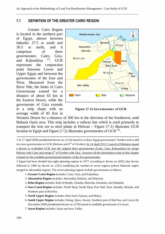
Figure (7-1) GCR location in Egypt
An Approach to the Methodology of Land Use Reutilization Management - Case Study of GCR
____________________________________________________________________________
196
7.1 DEFINITION OF THE GREATER CAIRO REGION
Greater Cairo Region
is located in the northern part
of Egypt, almost between
latitudes 27.5 at south and
30.5 at north, and it
comprises of three
governorates: Cairo, Giza,
and Kalyoubiya )1(. GCR
represents the conjunction
point between Lower and
Upper Egypt and between the
governorates of the East and
West. Measured from the
River Nile, the limits of Cairo
Governorate extend for a
distance of about 65 km in
the Eastern Desert, while the
governorate of Giza extends
in a strip shape with an
average width of 85 Km in
Western Desert for a distance of 300 km in the direction of the Southwest, until
Baharia Oasis area. This strip includes a railway line which is used primarily to
transport the iron ore to steel plants in Helwan – Figure (7-1) illustrates GCR
location in Egypt and Figure (7-2) illustrates governorates of GCR )2(.
ــــــــــــــــــ ـــ ـــــــــــ ــــــــــ ــــــــــــــ ــــــــ ــــــــــ ـــــــــــ ـــ ــــــــــــــــــ ـــ ـــــــــــ ــــــــــــــــــــــــ ـــ ـــــــــــ ــــــــــ ـــــــــــ ـــــ1 In 17 April 2008 presidential decree no. (114) issued to re-draw Egypt governorates’ borders and to add
two new governorates to GCR (Helwan and 6th of October). In 14 April 2011 Council of Ministers issued
a decree to re-divided GCR into the original three governorates (Cairo, Giza, Kalyoubiya) by merge
Helwan with Cairo and merge 6th of October with Giza , however all the information exists in this chapter
is based on the available governmental statistics of the five governorates.
2 Egypt had been divided into eight planning regions in 1977 according to decree no (495), that decree
followed in 1986 by decree no. (181) modifying the number to seven regions (where Matrouh region
merged to Alexandria region). The seven planning regions include governorates as follows:
1- Greater Cairo Region includes: Cairo, Giza, and Kalyobiya.
2- Alexandria Region includes: Alexandria, Beheira, and Matrouh.
3- Delta Region includes: Kafr el-Sheikh, Gharbia, Monufia, Damietta, and Dakahlia.
4- Suez Canal Region includes: North Sinai, South Sinai, Port Said, Suez, Ismailia, Sharqia, and
Northern part of Red Sea.
5- North Upper Region includes: Beni Suef, Faiyum, and Minya.
6- South Upper Region includes: Sohag, Qena, Aswan, Southern part of Red Sea, and Luxor (In
December 2009 presidential decree no. (378) issued to establish governorate of Luxor).
7- Asyut Region includes: Asyut and new Valley.
Figure (7-2) Governorates of GCR
Chapter 7 – GCR: existing conditions and land use reutilization urgency
__________________________________________________________________________
197
The total area of GCR is about 37000 km2 with urban agglomeration of about
650 km2 and Total population of about 20 million inhabitants represent 25% of
the total population in Egypt (as per 2010 CAPMAS estimates). Giza
Governorate represents about 80% of GCR area, since it includes vast tracts of
desert lands. Agricultural areas of great economic importance located in
Governorate of Kalyobia and utmost northern part of Giza.
7.1.1 REASONS OF SELECTING GCR
There are many reasons led to select GCR to be the case study of
testing the methodology of land use reutilization management which could be
categorized under the following two groups.
7.1.1.1 ECONOMIC AND CULTURAL IMPORTANCE OF GCR
GCR is the prime engine of economic growth and the main center of
the concentration of population in Egypt where it accommodates about 25% of
the total Egyptian population, mostly comprised of the central government
services with all of their major types and bureaucrats. GCR also accommodates
the main centers of industrial entities and a large business, as well as services
and commercial activities, which earn the region of its great importance.
The focus of the economic and cultural developments in the region is
clear. The magnitude of the cultural activities makes it the backbone of
intellectual, scientific and technical life in Egypt as a whole. GCR accomodates
the National Culture Center (Opera House), most of the large museums and the
vast majority of scientific research centers, as well as the major universities:
Cairo University, Ain Shams, Helwan, Al-Azhar, the American University and
most of the new private sector universities. The region also accommodates the
largest international airport in Egypt and one of the most important in the
Middle East and North Africa.
7.1.1.2 GCR LAND USE TRANSFORMATION PROCESSES
From urban planning point of view, GCR can not be considered
homogeneous region but it represents a comprehensive picture of the economic
and social diversity. GCR could be divided into several planning units in many
ways depending on the purpose of division. In terms of the administrative
divisions, the main ones are the three governorates. In terms of the land use,
the divisions are the main urban blocks with different uses in the center of the
region, surrounded by agricultural lands in the form of a crescent, opened in

An Approach to the Methodology of Land Use Reutilization Management - Case Study of GCR
____________________________________________________________________________
198
the southeast, and then surrounded by vast areas of desert land. But, if the goal
is to study the urban clusters, it is possible to divide the region into sections of
rapid and slow growth, or sections of planned areas and slum areas and so on.
What distinguishes GCR from other regions of Egypt beside its
economic importance is its largest urban block which may be found in all
countries of both the Middle East and Africa. This is linked to its both rapid
urban sprawl and urban transformation processes which led to much
inappropriate land uses calling for urgent and sometimes complicated land use
reutilization projects at different levels. That is why GCR has been considered
as the ideal region in Egypt to examine the methodology of managing land use
reutilization.
7.2 NATURAL CHARACTERISTICS OF GCR
Natural characteristics of GCR comprises of the study of the
followings:
7.2.1 GEOLOGICAL CHARACTERISTICS )1(
The sedimentary soil of Nile covers large areas of the agricultural lands
of GCR, the area of the Nile basin in various widths and depths starting from
12 km at Cairo Governorate area and it increases at the areas of Giza and
Kalyobia Governorates.
The rocks which occur in GCR at different locations are as follows:
• Layers of sandstone, limestone and clay, localized around both sides of the
Nile Valley, in the form of longitudinal strips at the eastern side of the
Nile Valley and adjacent to the agricultural lands from Khanka at the
North up to Al-Koraimat at the South, with widths average 5 km to 15 km.
Small areas of these rocks exist intermittently in the Eastern GCR at Wadi
Al Jufrah North of the Suez Road. At the Western side of the Nile Valley
it covers large areas between Giza - Oases Road and Cairo - Alexandria
desert Road. It also exists in the form of strips between the north-east of
Lake Qarun and Giza.
• Sandy Limestone, sand and gravel localized in the East extended from
Katameya Heights up to 10th
of Ramadan City and beyond GCR’s Eastern
ــــــــــــــــــ ـــ ـــــــــــ ــــــــــ ــــــــــــــ ــــــــ ــــــــــ ـــــــــــ ـــ ــــــــــــــــــ ـــ ـــــــــــ ــــــــــــــــــــــــ ـــ ـــــــــــ ــــــــــ ـــــــــــ ـــــ1 Ministry of planning, Egypt, (1997). The National Project for the development of GCR, P. 5
Chapter 7 – GCR: existing conditions and land use reutilization urgency
__________________________________________________________________________
199
borders. Both Cairo – Suez and Cairo – Ismaelia Roads are passing
through this configuration.
• White sandy limestone and clay are localized in the West, where they
extend for more than 200 km with about 40 km width. Most of it is
localized between Giza – Oasis Road and the Northern GCR borders.
• Basalt is localized at the East of GCR at Mount of Al Jufrah, tat he 32nd
Km of the Cairo - Suez Road, South of 10th
of Ramadan City and in Abu
Zaabal to the Northeast of Cairo, where the main basalt quarries exist. In
the West, It is found in the form of an arc expanded from north of Fayoum
up to Abu Rawash to the west of Giza and Imbaba, near Cairo -
Alexandria desert road. It also exists near Bahariya Oasis. The basalt
exists at those areas in the form of thick mattresses up to more than 50
meters.
• Composition of Red Mountain rocks consists of gravel, coarse grained
sand and sandstone containing iron filaments. One of the main areas of
this configuration is localized in Red Mountain area at the East of Cairo
(now known as the Green Mountain), and in the Petrified Forest at Maadi
– Katameya road.
• Rocks of Eocene Age exist in the Eastern part of GCR, in a strip shape,
from Eastern Border up to the Nile Valley bounded by Maadi – Sokhna
Road from the Northern side. This strip includes Katameya Mount, Wadi
Degla, Mokatam Mountain, Torah, and Helwan. In the Western area there
is in the western plateau of the Nile Valley in Al-Ahram and Al-Ayat. The
bulk of these rocks exist in the Bahariya Oasis forming the plateau around
the oases.
Seismic zones: There are two seismic belts crossing GCR, the first one starts
from Northeast to Southwest up to Bahariya oasis. The second one (red sea
Built) starts from Northwest and to Southeast. There is a third belt that may
affect the GCR which is Gulf of Aqaba belt.
Many Basalt and Limestone Quarries are located in different places at GCR;
some of them occurred during urban sprawl and urban transformation
processes, along with some basic industrials areas which located in
inappropriate locations and causing urban problems which call for land use
reutilization projects.
7.2.2 TOPOGRAPHIC CHARACTERISTICS )1(
ـــــــــــــ ـــ ــــــــــــــــــ ـــ ـــــــــــ ــــــــــــــــــ ـــــــــــ ـــ ــــــــــــــــــ ـــ ـــــــــــ ــــــــــ ــــــــــــــ ـــ ـــــــــــ ــــــــــ ـــــــــــ ـــ ــــــــــ1 Ministry of planning, Egypt, (1997). The National Project for the development of GCR, P. 3
An Approach to the Methodology of Land Use Reutilization Management - Case Study of GCR
____________________________________________________________________________
200
Topography of GCR terrain is characterized by its variations in heights.
In the river valley, the height rate is not exceeding 20 meters above sea level,
while in the Eastern periphery is approaching 500 meters above sea level. In
the West side, the height exceeds 200 meters above sea level at Abu Rawash
Plateau, which overlooks the river valley from the West. The Plateau of the
Bahariya Oasis has levels more than 200 meters. Plains extend between those
hills and plateaus, where the elevation is less than 200 meters.
GCR Topographic terrain could be classified into two morphological units as
follows:
Alluvial Plains and Water-Bodies:
Alluvial plains represent an area of about 1560 km 2 (less than 5% of
GCR), which include the recent alluvial plains where floodplain of the River
Nile exists. These areas include the agricultural lands, hence the rural activities
and some scattered urbanization which are causing the erosion of the
agricultural land.
The River Nile crosses the floodplain from the South to the North
which is characterized by its islands and structures like bridges, locks and
dams. In some parts of this floodplain, especially in the area of Cairo City,
there are sedimentations of the ancient civilization’s land layers, which exceed
a thickness of ten meters. In addition to the recent alluvial plains, there are the
ancient ones which are comprised of gravel and sand and border the floodplain
from both, the East and West and rises gradually for more than 50 meters. In
general, these alluvial plains represent both, the agricultural expansion and
urban sprawl.
Hills and Plateaus:
Hills and Plateaus occur at the Eastern part of the Governorate
of Giza, south of Cairo and also marked the areas around the Bahariya Oasis in
the far Southwest. The surfaces of these hills and plateaus are relatively plain
and have the elevations of more than 300 meters above sea level, in some
locations. Many of those hills and Plateaus have deep cliffs faces, such as
Mokattam Hill, Plateau of Pyramids, Plateau of Abu Rawash and at Bahariya
Oasis.
Most of the urbanized areas in GCR are concentrated near the river Nile, which
cause the erosion of the agricultural land and at the same time makes GCR a
more urbanized area with one of the highest population densities all over the
world. This causes many urban problems which call for land use reutilization
projects.
Chapter 7 – GCR: existing conditions and land use reutilization urgency
__________________________________________________________________________
201
7.2.3 HYDRO-GEOLOGICAL CHARACTERISTICS )1(
One of the largest and highest hills in Egypt is located at the Southern
side of GCR; with its height more than 600 meters above sea level. Main storm
water drainage line, separating the basins of the Red Sea and the River Nile,
passes through these hills from South to North. During rainstorms, the hill
receive water with an amount of up to 10 mm per day (or 35 million m3 / day)
which may continue for more than one day and may be repeated once every
four or five years. Floods occur during rainstorms and run through storm water
drains; like Wadi Degla and Wadi Houf which causes threats for some GCR
areas. Minor storm water drains exist near Giza Pyramids.
Within land use reutilization projects when settling new land uses, storm water
drainage should be considered either by landscape treatment or by avoiding.
7.2.4 CLIMATIC CHARACTERISTICS )2(
GCR climatic conditions are homogeneous to a large extent. It
represents a compromise between the North Coast and the Delta Climate on
one side and the Nile Valley Climate on the other. The lowest winter daily
mean temperature in GCR is (13.6°C) in January, while the maximum daily
mean temperature is (28.4°C) in July. The most stable season is the summer,
particularly the month of August and September. The maximum feeling of high
temperature is in May, concurrent with the hot and dusty local winds of
Khamaseen.
The maximum relative humidity occurs in December and January,
while falling to the lowest in May, linked with the wind of Khamaseen. The
prevailing wind in GCR blowS from North direction. It turns to the North-West
in the months of July and August, and turns to the North-East in the fall and
winter. The amount of annual rainfall in GCR is averaged between 22 mm and
25 mm, where the rainy season starts in October, and reaches the maximum in
the month of December. Then it starts to decline until the month of May, and
rainfall disappears completely during the summer four months from June to
September.
7.3 INFRASTRUCTURAL CHARACTERISTICS OF GCR
ـــــــــــــ ـــ ــــــــــــــــــ ـــ ـــــــــــ ــــــــــــــــــ ـــــــــــ ـــ ــــــــــــــــــ ـــ ـــــــــــ ــــــــــ ــــــــــــــ ـــ ـــــــــــ ــــــــــ ـــــــــــ ـــ ــــــــــ1 Ministry of Planning, Egypt, (1997). The National Project for the Development of GCR, P. 9
2 Ministry of Planning, Egypt, (1997). The National Project for the development of GCR, P. 10

An Approach to the Methodology of Land Use Reutilization Management - Case Study of GCR
____________________________________________________________________________
202
The infrastructural characteristics include different types of
constructions which represent the backbone of the region.
7.3.1 ROADS AND TRANSPORTATION
o Roads Network
The main axes of road networks at the GCR national level could be listed as
follows:
• Axis of Cairo - Alexandria desert Road.
• Axis of Qanater and Khatatba and Tawfeqia Road.
• Axis of Cairo - Alexandria Agricultural Road.
• Axis of Cairo - Ismailia Agricultural Road.
• Axis of Hykestep – Belbeis Road.
• Axis of Cairo - Ismailia Desert Road.
• Axis of Cairo - Suez Road.
• Axis of Maadi - Katameya - Ain Sokhna.
• Axis of the Upper Egypt Road East of the Nile.
• Axis of the Upper Egypt Road West of the Nile.
• Axis of Cairo – Fayoum Road.
• Axis of Cairo - Assiut Desert Road.
GCR has a large group of regional roads which link its different areas. Most
important of these regional roads could be described as follows:
• Ring Road which surrounds GCR main agglomeration area and crosses
the Nile at Munib and Maadi in the South and at Warraq in the North.
• Axis of the Nile Corniche Road, which runs through the region from
North to South, and considered the Northern Entrance from Alexandria
Agricultural Road and extends until the beginning of Upper Egypt Road
in the South.
• Axis of 26 July, Freeway linking Lebanon Square at Mohandiseen
District with Cairo - Alexandria Desert Road with a length of 15 km. It
has 3 lanes in each direction and 30 bridges across the canals and
secondary roads.
• Axis of Al-Haram (Pyramid) Road and Faisal Road at Giza which link
the West of the region at the entrances of Alexandria Desert Road,
Fayoum Road and Assiut Desert Road with the East of Region through
Salah Salem and Al Orouba Roads up to Cairo International Airport
ending by Ismailia Desert Road.
• Axis of Autostrad Road which connects the South and North of the
region, starting at the city of May 15 May through Maadi, Basateen,
Nasr City, intersecting with Suez Desert Road, intersecting with Al
Orouba Road then Gisr Al Suez and finally Ismaelia Desert Road.
Chapter 7 – GCR: existing conditions and land use reutilization urgency
__________________________________________________________________________
203
• Axis of West of Nile which extends from Al-Khatatba on the borders of
the region with Beheira Governorate in the North down to South at
Upper Egypt Road through Imbaba and whole Giza.
In addition to the national and regional trunk roads, there are many local roads
connecting the different zones and districts in the region. Many Bridges are
connecting GCR governorates together, across the river Nile which had been
constructed at different times and have different specifications and conditions.
Most important of these bridges are; Giza Bridge - Bridge El Malek Al Saleh -
University Bridge - Bridge of Kasr El Nil - 6 of October Bridge – 15 May
Bridge - Imbaba Bridge - Marazeek Bridge - Qanater Bridge – Roud Al Farag
Bridge.
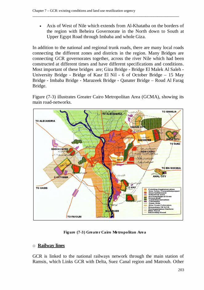
Figure (7-3) illustrates Greater Cairo Metropolitan Area (GCMA), showing its
main road-networks.
o Railway lines
GCR is linked to the national railways network through the main station of
Ramsis, which Links GCR with Delta, Suez Canal region and Matrouh. Other
Figure (7-3) Greater Cairo Metropolitan Area
An Approach to the Methodology of Land Use Reutilization Management - Case Study of GCR
____________________________________________________________________________
204
links with different locations of Upper Egypt are available by Giza Railway
Station. Both Ramsis and Giza Railway Stations are linked together by railway
line across the Nile through Imbaba Bridge.
In addition to the previous lines, there are other lines which are located to the
west of the Nile (Imbaba - Itai Al-Baroud and Ithad – Mirgham) which has
been constructed to reach Alexandria without crossing the Nile.
There is also a commercial railway-line with a length of about 300 Km which
is used primarily to transport iron ore from Oasis to steel plants in Helwan, this
line is crossing the Nile through Al-Marazeek
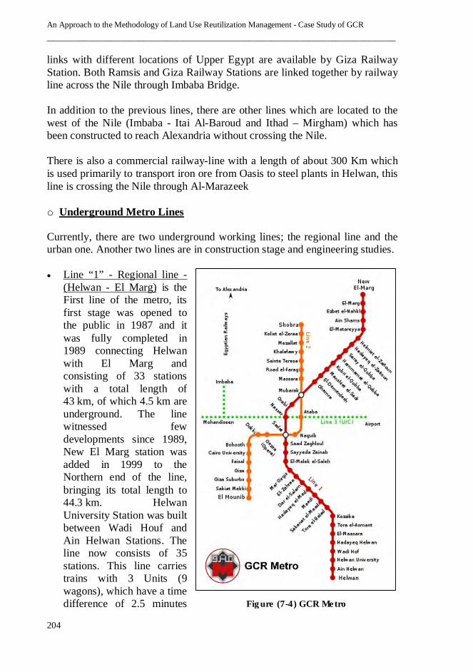
o Underground Metro Lines
Currently, there are two underground working lines; the regional line and the
urban one. Another two lines are in construction stage and engineering studies.
• Line “1” - Regional line -
(Helwan - El Marg) is the
First line of the metro, its
first stage was opened to
the public in 1987 and it
was fully completed in
1989 connecting Helwan
with El Marg and
consisting of 33 stations
with a total length of
43 km, of which 4.5 km are
underground. The line
witnessed few
developments since 1989,
New El Marg station was
added in 1999 to the
Northern end of the line,
bringing its total length to
44.3 km. Helwan
University Station was built
between Wadi Houf and
Ain Helwan Stations. The
line now consists of 35
stations. This line carries
trains with 3 Units (9
wagons), which have a time
difference of 2.5 minutes Figure (7-4) GCR Metro

Chapter 7 – GCR: existing conditions and land use reutilization urgency
__________________________________________________________________________
205
and a maximum speed of 100 km/h. The line can carry 60,000 Passengers
per hour in each direction.
• Line “2” - Urban line - (Shobra El Kheima - El Mounib) is the second line
of the metro connecting Shoubra El Kheima with Cairo University, with an
extension to Giza. It is the first line in history to have a tunnel going under
the Nile. The tunnel under the Nile is 8.35 m in internal diameter Extending
21.5 kilometres with 20 stations. The main difference between Lines 1 and
2 is that Line 1 uses an overhead line while Line 2 uses the third-rail
system. The construction of the line was finished in October 2000 and was
later extended to El Mounib.
• Line “3” (Imbaba / Mohandiseen - Cairo Int'l Airport) is currently under
construction and extends from the northwest of GCR at Imbaba to the
northeast at Heliopolis and will eventually also serve Cairo International
Airport. The line crosses under the two branches of the River Nile, as does
Line 2. The total length of the line is approximately 33 kilometres most of
which is in bored tunnel and will be implemented in four phases. The
implementation of Line No. 3 will start with Attaba to Abbasia section, the
first phase has a completion date set at October 2011, followed by the
second phase from Abbasia to Heliopolis which are the most urgent
sections for the transportation needs and planned to be finished in October
2013. Third phase will connect Attaba Square with Sphinx Square and has
the finishing date of October 2015. The fourth phase will connect Sphinx
Square with Lebanon Square and has the finishing date of October 2017.
• Line “4” (October-Oasis Highway - Mubarak Police Academy) is under
preparing its engineering studies, it is planned to run from Haram District
reaching the New Cairo District literally connecting GCMA from West to
East.
Figure (7-4) illustrates GCR metro network )1(.
o River Transportation
The River Nile Runs through GCR from the south to the north, it has had a
major role in the past and still plays a role in the transport of goods to Cairo. It
is currently being used also by river bus network paths to transport passengers,
in addition to the use of the cruise. Some ports like Ain Al-Sira and Helwan
play a role in the carriage of raw materials and products, especially from Upper
Egypt.
ـــــــــــــ ـــ ــــــــــــــــــ ـــ ـــــــــــ ــــــــــــــــــ ـــــــــــ ـــ ــــــــــــــــــ ـــ ـــــــــــ ــــــــــ ــــــــــــــ ـــ ـــــــــــ ــــــــــ ـــــــــــ ـــ ــــــــــ1 http://en.wikipedia.org/wiki/Cairo_metro
An Approach to the Methodology of Land Use Reutilization Management - Case Study of GCR
____________________________________________________________________________
206
o Air Transportation
GCR include Cairo International Airport located to the North-East of Cairo
City around 15 km from the business area of the city. It is the second busiest
airport in Africa after OR Tambo International Airport in South Africa. Over
65 airlines use Cairo airport (including charter airlines) and 9 cargo airlines. It
has the potential to be a major hub with its positioning between Africa, the
Middle East and Europe (especially with facilities for the Airbus A380, the
largest passenger airliner in the world). In 2009, the airport served about 15
million passengers. The airport has three terminals, with the third (and largest)
opened in 2009, a third parallel runway is currently under construction and will
replace the current crossing runway once it goes into operation.
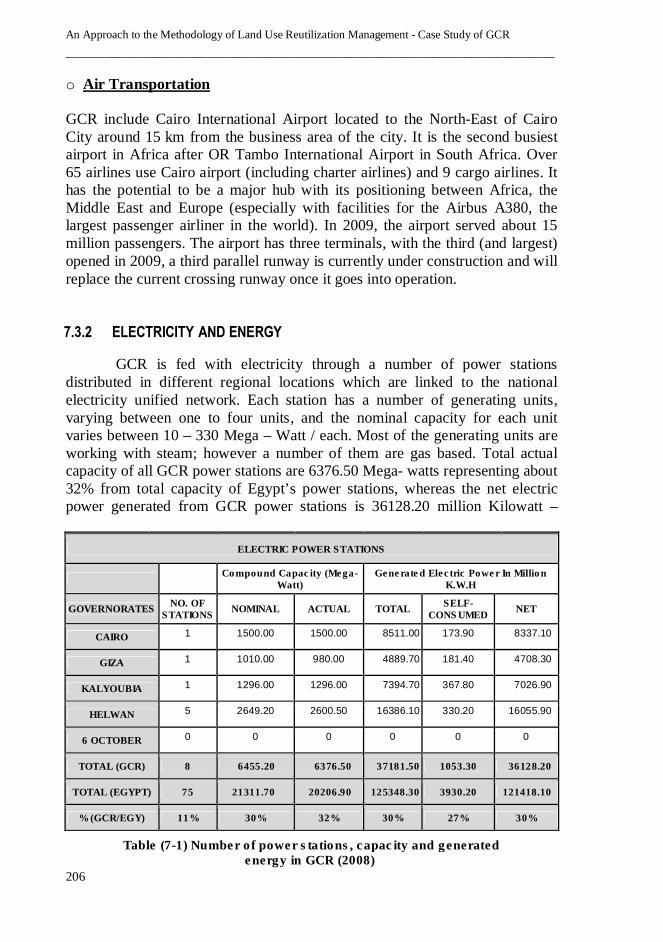
7.3.2 ELECTRICITY AND ENERGY
GCR is fed with electricity through a number of power stations
distributed in different regional locations which are linked to the national
electricity unified network. Each station has a number of generating units,
varying between one to four units, and the nominal capacity for each unit
varies between 10 – 330 Mega – Watt / each. Most of the generating units are
working with steam; however a number of them are gas based. Total actual
capacity of all GCR power stations are 6376.50 Mega- watts representing about
32% from total capacity of Egypt’s power stations, whereas the net electric
power generated from GCR power stations is 36128.20 million Kilowatt –
ELECTRIC POWER STATIONS
Compound Capacity (Mega-
Watt) Generated Electric Power In Million
K.W.H
GOVERNORATES NO. OF
STATIONS NOMINAL ACTUAL TOTAL
SELF-CONSUMED
NET
CAIRO 1 1500.00 1500.00 8511.00 173.90 8337.10
GIZA 1 1010.00 980.00 4889.70 181.40 4708.30
KALYOUBIA 1 1296.00 1296.00 7394.70 367.80 7026.90
HELWAN 5 2649.20 2600.50 16386.10 330.20 16055.90
6 OCTOBER 0 0 0 0 0 0
TOTAL (GCR) 8 6455.20 6376.50 37181.50 1053.30 36128.20
TOTAL (EGYPT) 75 21311.70 20206.90 125348.30 3930.20 121418.10
% (GCR/EGY) 11% 30% 32% 30% 27% 30%
Table (7-1) Number of power stations, capacity and generated energy in GCR (2008)

Chapter 7 – GCR: existing conditions and land use reutilization urgency
__________________________________________________________________________
207
hours representing about
30% from the total net
electric power generated
at the level of whole
Egypt. Table (7-1)
illustrate the number of
power stations, their
capacities and generated
energy in GCR in 2008,
whereas Table (7-2) and
Figure (7-5) illustrate the
electric capacity in GCR
distributed by kinds of
usage in 2008 )1(.
ـــــــــــــ ـــ ــــــــــــــــــ ـــ ـــــــــــ ــــــــــــــــــ ـــــــــــ ـــ ــــــــــــــــــ ـــ ـــــــــــ ــــــــــ ــــــــــــــ ـــ ـــــــــــ ــــــــــ ـــــــــــ ـــ ــــــــــ1 Central Agency for Public Mobilization and Statistics, 2008
Industry
Agriculture, Irrigation
and Drainage
Transport-ation
Houses, Trade and
Service Establish-
ments
Governmental Authorities
Other Public Purposes
Total
GCR 9307 320 59 16411 2560 2582 31237
EGY 37506 4228 825 42562 5874 15749 106744
% (G/E) 25% 8% 7% 39% 44% 16% 29%
Industry Houses
Trade And Service
Establish-ments
Hotel Service –
Private Hospitals
Other Total
N.
Gas
L.
Gas
N.
Gas
L.
Gas
N.
Gas
L.
Gas
N.
Gas
L.
Gas
N.
Gas
L.
Gas
N.
Gas
L.
Gas
GCR 598867 6708 650453 762349 0 159372 0 432 7815029 2846 9077363 931707
EGY 1796955 10439 841581 3421328 0 452461 0 6586 25994851 2906 28633387 3893720
% 33% 64% 77% 22% 0% 35% 0% 7% 30% 98% 32% 24%
Table (7-2) (1)
Electric capacity (Million K.W.H) in GCR distributed by kinds of usage (2008)
Figure (7-5) (1)
Electric capacity in GCR / Egypt
Table (7-3) (1)
Amount of sold gas (by ton) and its usage in GCR and Egypt
An Approach to the Methodology of Land Use Reutilization Management - Case Study of GCR
____________________________________________________________________________
208
Natural and liquid gases represent two of the most used types of energy
for different purposes in GCR in particular and Egypt in general. The amount
of natural gas used for different purposes in GCR represent about 32% from
total amount used in whole Egypt, whereas the used liquid gas in GCR
represent about 24% from total amount used in whole Egypt. These figures are
clear indicators of the level of services provided in GCR, comparing with the
rest of Egypt’s regions – Table (7-3) illustrates the amount of sold gas and its
usage in GCR and Egypt.
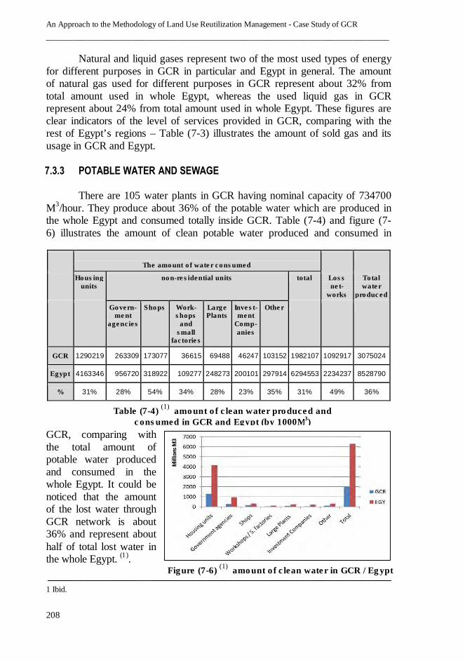
7.3.3 POTABLE WATER AND SEWAGE
There are 105 water plants in GCR having nominal capacity of 734700
M3/hour. They produce about 36% of the potable water which are produced in
the whole Egypt and consumed totally inside GCR. Table (7-4) and figure (7-
6) illustrates the amount of clean potable water produced and consumed in
GCR, comparing with
the total amount of
potable water produced
and consumed in the
whole Egypt. It could be
noticed that the amount
of the lost water through
GCR network is about
36% and represent about
half of total lost water in
the whole Egypt. )1(.
ــــــــــــــــــ ـــ ـــــــــــ ــــــــــ ــــــــــــــ ــــــــ ــــــــــ ـــــــــــ ـــ ــــــــــــــــــ ـــ ـــــــــــ ــــــــــــــــــــــــ ـــ ـــــــــــ ــــــــــ ـــــــــــ ـــــ1 Ibid.
The amount of water consumed
Housing units
non-residential units total Loss net-
works
Total water
produced
Govern-ment
agencies
Shops Work-shops
and small
factories
Large Plants
Invest-ment
Comp-anies
Other
GCR 1290219 263309 173077 36615 69488 46247 103152 1982107 1092917 3075024
Egypt 4163346 956720 318922 109277 248273 200101 297914 6294553 2234237 8528790
% 31% 28% 54% 34% 28% 23% 35% 31% 49% 36%
Table (7-4) (1)
amount of clean water produced and
consumed in GCR and Egypt (by 1000M3)
Figure (7-6) (1)
amount of clean water in GCR / Egypt

Chapter 7 – GCR: existing conditions and land use reutilization urgency
__________________________________________________________________________
209
GCR accounts for almost one third of the capacity of sewage treatment
plants at the level of whole Egypt – table (7-5) illustrates the capacities and
discharge of sewage treatment plants in GCR (by governorate) in relation with
total capacities and discharge in Egypt.
7.3.4 COMUNICATION TECHNOLOGIES
Egypt has long been the cultural and informational centre of the Arab
World; GCR is the largest centre of publishing and broadcasting in Egypt,
Middle East and North Africa. In addition to the traditional communication
technologies like press, mail, landline telephones, radio and TV, GCR is the
national center of introducing the new communication technologies in Egypt
which could be summarized as follows:
• Cellular Communications have been launched in Egypt initially through
public sector in 1997. In 1998, it has been transferred to a new founded
private sector company, as the first private cellular communication
provider. Currently, based in GCR, there are three providers allowing for
several communication services such as 3.5G and 3.75G services.
• Broadband Internet Access was introduced commercially in 2000 as
ADSL. The service was initially offered in big cities such as Cairo, Giza
and gradually spread to cover more Governorates of Egypt. In 2007,
WiMax (Worldwide Interoperability for Microwave Access) technology
has been followed by cellular communication providers who provide fixed
and fully mobile Internet access technology.
• Broadcast Satellite Technologies are introduced by the Egyptian Satellite
Company “Nilesat” established in 1996 through series of Egyptian
communications satellites and their associated ground control stations and
Governorates No. of
stations
Designed capacity (100 M3/
Hour)
Actual capacity
Actual discharge (1000m3)
CAIRO 126 40776 25167 2152972
GIZA 26 9238 5731 453132
KALYOUBIA 55 12473 9305 324725
HELWAN 4 6560 3585 98787
6-Oct 17 3410 1176 100800
GCR 228 72457 44964 3130416
Egypt 949 204997 125306 9781034
% (GCR/EGY) 24% 35% 36% 32%
Table (7-5) Capacities / discharge of Sewage treatment plants in GCR and Egypt (by 1000M
3)
An Approach to the Methodology of Land Use Reutilization Management - Case Study of GCR
____________________________________________________________________________
210
up linking facilities. The company has two ground stations, a primary one
in 6th
of October City and a secondary one in Alexandria.
• Intelligent Buildings and Smart Homes are recently exist in some GCR
new communities through distinguished business and residential complexes
owned and operated by private sector investors who construct stand alone
ICT (information and communications technology) infrastructure for each
complex to provide computerized control system and intelligent network of
electronic devices, to monitor, control and integrate the mechanical and
lighting systems in both building level and whole complex level.
7.4 SOCIO-ECONOMICAL CHARACTERISTICS OF GCR
Management of land use reutilization projects require deep
understanding of the socio-economical characteristics pertaining to all
stakeholders may affect on or affected by these types of projects, as many of
these characteristics are governing elements in several 3PM processes. This
section studies and analyzes the socio-economical characteristics of GCR.
7.4.1 POPULATION CHARACTERISTICS
GCR population is 18,448,076 as per 2006 census (the estimated
population in January 2010 according to the natural increase and the final
results of 2006 as per CAPMAS is 19,622,652), it represents about 25% of the
total population of Egypt– table (7-6) illustrate the population of GCR, its
current and former governorates and percentage from Egypt’s whole
population.
EGYPT GCR Cairo Giza Kalyobiya Helwan 6-Oct
Population (2006 census)
72,798,031 18,448,076 6,758,581 3,143,486 4,251,672 1,713,278 2,581,059
Population (Jan. 2010 Estimates)
77,775,247 19,622,652 7,137,218 3,326,444 4,546,564 1,831,505 2,780,921
% (population 2010 / Egypt population 2010)
- 25.2% 9.2% 4.3% 5.8% 2.4% 3.6%
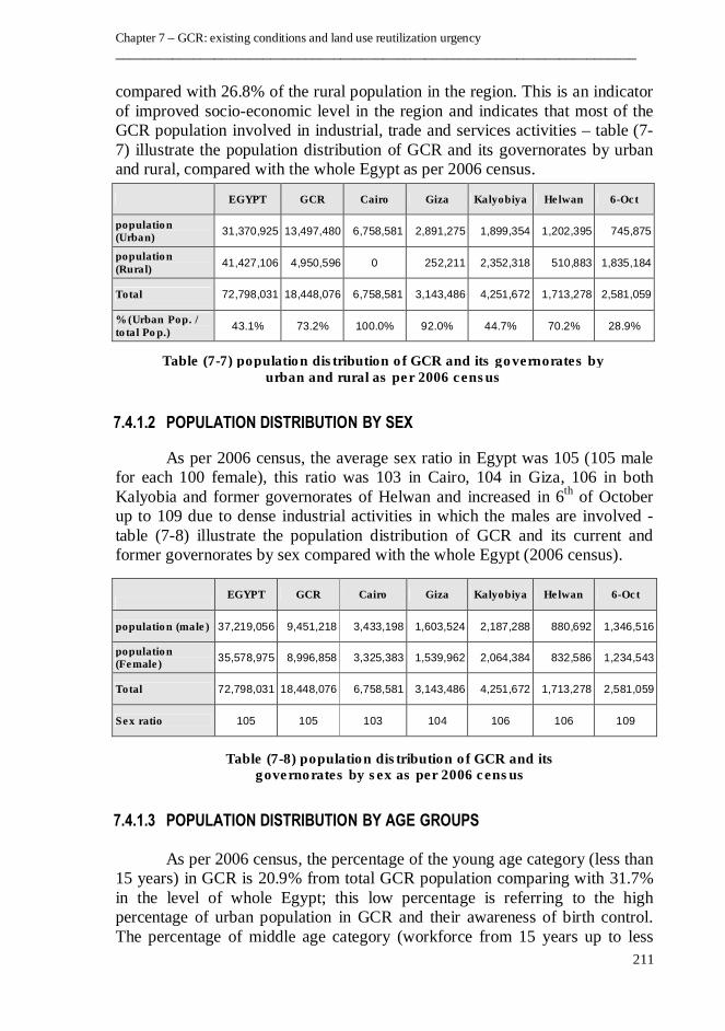
7.4.1.1 URBAN AND RURAL POPULATION DISTRIBUTION
As per 2006 census, the urban population percentage in Egypt is 43.1%;
this percentage is extremely increased in the level of GCR to reach 73.2%
Table (7-6) population of GCR and its governorates in 2006 and 2010
Chapter 7 – GCR: existing conditions and land use reutilization urgency
__________________________________________________________________________
211
compared with 26.8% of the rural population in the region. This is an indicator
of improved socio-economic level in the region and indicates that most of the
GCR population involved in industrial, trade and services activities – table (7-
7) illustrate the population distribution of GCR and its governorates by urban
and rural, compared with the whole Egypt as per 2006 census.
7.4.1.2 POPULATION DISTRIBUTION BY SEX
As per 2006 census, the average sex ratio in Egypt was 105 (105 male
for each 100 female), this ratio was 103 in Cairo, 104 in Giza, 106 in both
Kalyobia and former governorates of Helwan and increased in 6th
of October
up to 109 due to dense industrial activities in which the males are involved -
table (7-8) illustrate the population distribution of GCR and its current and
former governorates by sex compared with the whole Egypt (2006 census).
7.4.1.3 POPULATION DISTRIBUTION BY AGE GROUPS
As per 2006 census, the percentage of the young age category (less than
15 years) in GCR is 20.9% from total GCR population comparing with 31.7%
in the level of whole Egypt; this low percentage is referring to the high
percentage of urban population in GCR and their awareness of birth control.
The percentage of middle age category (workforce from 15 years up to less
EGYPT GCR Cairo Giza Kalyobiya Helwan 6-Oct
population (Urban)
31,370,925 13,497,480 6,758,581 2,891,275 1,899,354 1,202,395 745,875
population (Rural)
41,427,106 4,950,596 0 252,211 2,352,318 510,883 1,835,184
Total 72,798,031 18,448,076 6,758,581 3,143,486 4,251,672 1,713,278 2,581,059
% (Urban Pop. / total Pop.)
43.1% 73.2% 100.0% 92.0% 44.7% 70.2% 28.9%
EGYPT GCR Cairo Giza Kalyobiya Helwan 6-Oct
population (male) 37,219,056 9,451,218 3,433,198 1,603,524 2,187,288 880,692 1,346,516
population (Female)
35,578,975 8,996,858 3,325,383 1,539,962 2,064,384 832,586 1,234,543
Total 72,798,031 18,448,076 6,758,581 3,143,486 4,251,672 1,713,278 2,581,059
Sex ratio 105 105 103 104 106 106 109
Table (7-7) population distribution of GCR and its governorates by urban and rural as per 2006 census
Table (7-8) population distribution of GCR and its governorates by sex as per 2006 census

An Approach to the Methodology of Land Use Reutilization Management - Case Study of GCR
____________________________________________________________________________
212
than 60 years) in GCR is 62.6% from total GCR population which is almost the
same of Egypt. The percentage of older people category in GCR is 6.1% which
is also the same for Egypt - figure (7-7) illustrate the age structure diagram per
10 years (population pyramid) for GCR population as per 2006 census.
7.4.1.4 POPULATION ANNUAL GROWTH AND POPULATION DENSITY
As per CAPMAS estimates, the rate of annual population growth in
Egypt (2009 – 2010) was 2.21%, where it was less for GCR (1.98%) which
was differing from governorate to another; 1.41% for Cairo, 1.50% for Giza,
2.15% for Kalyobiya, 2.27% for Helwan, and 3.53% for 6th
of October. GCR
gross population density was 504 People / Km2 (as per 2006 census), where the
net population density (by counting only GCR urban block area) was about
42000 people / Km2
which is considered as one of the highest, all over the
world.
7.4.1.5 INTERNAL IMMIGRATION
GCR is the most attractive region for internal immigration, whereas (as
per 2010 CAPMAS estimates) its population’s annual growth rate was 1.98%
and its natural population increase rate (percentage of births minus deaths) was
1.92%, which means that the net immigration rate was 0.06%. In 2010 and at
the level of internal immigration among GCR governorates, Cairo governorate
became population exporter mainly to the former governorates of Helwan and
6th of October, where Cairo’s population annual growth rate in 2010 was
1.41% and its natural population increase rate was 1.89% which means that
Cairo average of net immigration rate was (- 0.48%). The main reasons for that
are the available facilities and labour force in the former two governorates
represented in existing of modern mixed use communities and existing of
several job vacancies in both production and service sectors.
Figure (7-7) Population Pyramid of GCR in 2006

Chapter 7 – GCR: existing conditions and land use reutilization urgency
__________________________________________________________________________
213
7.4.2 HUMAN DEVELOPMENT SERVICES
Studies and analysis of human development services are completing the whole
picture of the Socio-economic characteristics of the region and its residents.
Usually the main significant two items are education and health-care.
7.4.2.1 EDUCATION SERVICES
Education service studies include the education indicators for number of
schools, classrooms, classroom density, and its sufficiency comparing with the
common planning rates )1(. In the level of region, studies include the number of
universities, number of academic staff and enrolled students – Tables (7-9), (7-
10) )2( illustrate some important figures and rates related to education services.
GCR Cairo Giza Kalyobiya Helwan 6-Oct
No. of Schools 8,412 3,238 1,187 1,745 1,045 1,197
No. of Classes 96,859 36,584 15,464 21,414 10,733 12,664
No. of students 4,035,858 1,386,385 686,822 944,855 422,592 595,204
Class density 42 38 44 44 39 47
GCR Cairo Giza Kalyobiya Helwan 6-Oct
Governmental universities
No. of Universities 6 2 1 1 2 0
No. of Staff 36,452 18,595 10,608 3,002 4,247 0
No. of students 993,317 535,608 293,425 59,428 104,856 0
Private sector universities
No. of Universities 10 1 0 0 5 4
No. of Staff 3,524 137 0 0 1,108 2,279
No. of students 48,552 1,130 0 0 13,523 33,899
H. education Rate 5400 college student / 100,000 people (for GCR)
ـــــــــــــ ـــ ــــــــــــــــــ ـــ ـــــــــــ ــــــــــــــــــ ـــــــــــ ـــ ــــــــــــــــــ ـــ ـــــــــــ ــــــــــ ــــــــــــــ ـــ ـــــــــــ ــــــــــ ـــــــــــ ـــ ــــــــــ1 Common rates of education services in USA and European countries are averaging between 16 to 25
student / class for schools and between 700 to 4000 student / 100,000 people for universities.
2 Governmental universities include Al-Azhar university and Mubarak Police Academy.
private universities include: The modern university for technology & information (Cairo) - American
university, Misr international university, British university, French university, The Egyptian-Russian
university (Helwan) - 6 October University, October Modern Science & Arts University, Misr
Technology &Science University, El-Ahram Canadian University (6th of October) – CAPMAS (2009)
Table (7-10) No. of GCR universities, Staff and students - governmental and private (2008-2009)
Table (7-9) No. of schools, classes, students and class density in GCR (2008-2009)
An Approach to the Methodology of Land Use Reutilization Management - Case Study of GCR
____________________________________________________________________________
214
Generally, the followings could be noted from previous tables:
Most of the GCR governmental classes of pre-university education
suffering from high density comparing with the common rates used in USA
and European countries (almost double), which shows the need to provide
more classes and to be considered within re-land use projects. The rate of
higher education students to GCR total population is actually higher than the
rate of USA and Europe; this may refer to the centralization of the large
number of governmental universities and most of the private universities in
GCR, however this rate should be seen with the level of education quality,
university facilities and researches offered by each university.
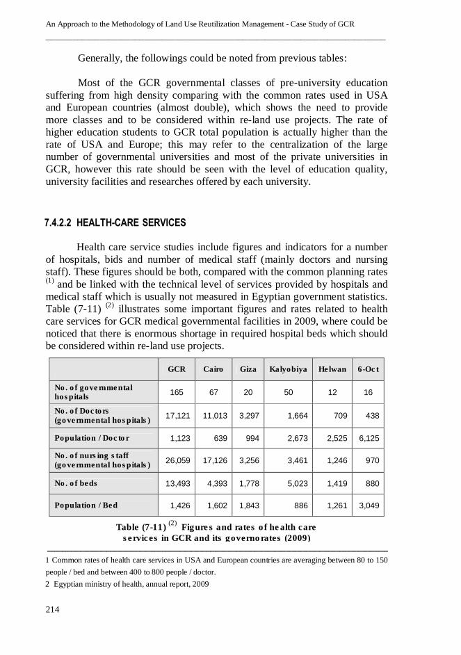
7.4.2.2 HEALTH-CARE SERVICES
Health care service studies include figures and indicators for a number
of hospitals, bids and number of medical staff (mainly doctors and nursing
staff). These figures should be both, compared with the common planning rates )1( and be linked with the technical level of services provided by hospitals and
medical staff which is usually not measured in Egyptian government statistics.
Table (7-11) )2( illustrates some important figures and rates related to health
care services for GCR medical governmental facilities in 2009, where could be
noticed that there is enormous shortage in required hospital beds which should
be considered within re-land use projects.
ــــــــــــــــــ ـــ ـــــــــــ ــــــــــ ــــــــــــــ ــــــــ ــــــــــ ـــــــــــ ـــ ــــــــــــــــــ ـــ ـــــــــــ ــــــــــــــــــــــــ ـــ ـــــــــــ ــــــــــ ـــــــــــ ـــــ1 Common rates of health care services in USA and European countries are averaging between 80 to 150
people / bed and between 400 to 800 people / doctor.
2 Egyptian ministry of health, annual report, 2009
GCR Cairo Giza Kalyobiya Helwan 6-Oct
No. of governmental hospitals
165 67 20 50 12 16
No. of Doctors (governmental hospitals)
17,121 11,013 3,297 1,664 709 438
Population / Doctor 1,123 639 994 2,673 2,525 6,125
No. of nursing staff (governmental hospitals)
26,059 17,126 3,256 3,461 1,246 970
No. of beds 13,493 4,393 1,778 5,023 1,419 880
Population / Bed 1,426 1,602 1,843 886 1,261 3,049
Table (7-11) (2)
Figures and rates of health care
services in GCR and its governorates (2009)
Chapter 7 – GCR: existing conditions and land use reutilization urgency
__________________________________________________________________________
215
7.4.3 LABOUR FORCE AND UNEMPLOYMENT RATE
GCR has an effective labour force of about 5,744,000 people (15 years
old and over) represents about 23% of the total labour force in Egypt as of
2008 statistics done by CAPMAS. GCR unemployment rate is equal to 9.14%
which is not far from the national rate of 8.69%. This large unemployment rate
should be seen and dealt with during several processes of re-land use projects
by providing job opportunities either during planning or execution stages.
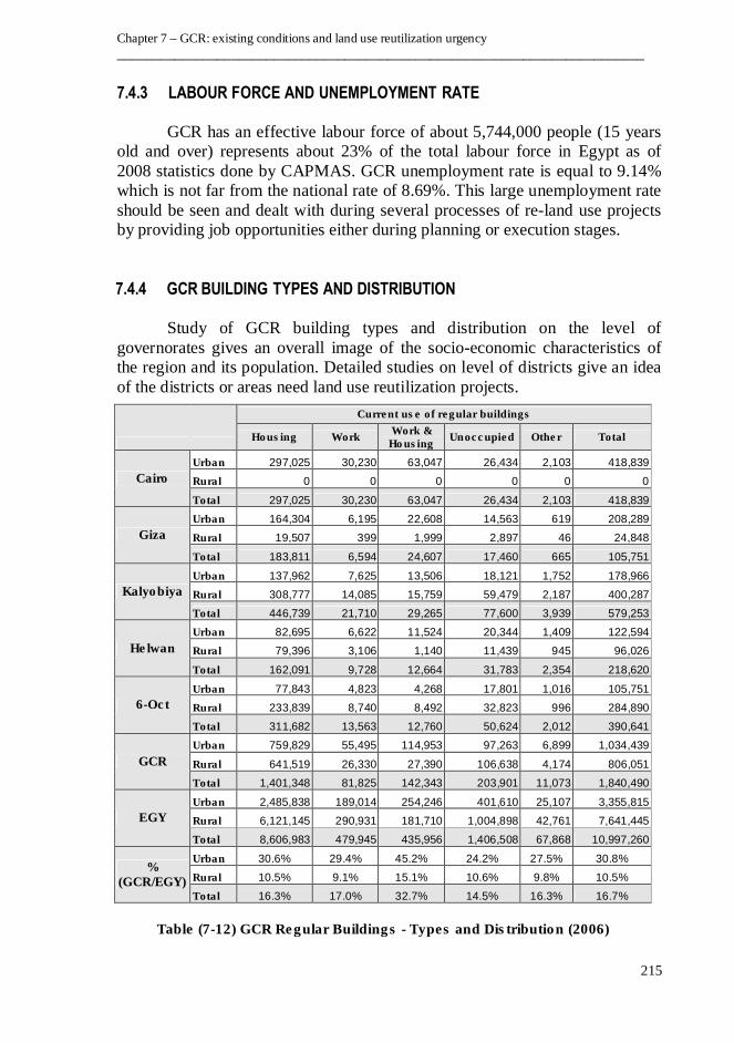
7.4.4 GCR BUILDING TYPES AND DISTRIBUTION
Study of GCR building types and distribution on the level of
governorates gives an overall image of the socio-economic characteristics of
the region and its population. Detailed studies on level of districts give an idea
of the districts or areas need land use reutilization projects.
Current use of regular buildings
Housing Work Work & Housing
Unoccupied Other Total
Cairo
Urban 297,025 30,230 63,047 26,434 2,103 418,839
Rural 0 0 0 0 0 0
Total 297,025 30,230 63,047 26,434 2,103 418,839
Giza
Urban 164,304 6,195 22,608 14,563 619 208,289
Rural 19,507 399 1,999 2,897 46 24,848
Total 183,811 6,594 24,607 17,460 665 105,751
Kalyobiya
Urban 137,962 7,625 13,506 18,121 1,752 178,966
Rural 308,777 14,085 15,759 59,479 2,187 400,287
Total 446,739 21,710 29,265 77,600 3,939 579,253
Helwan
Urban 82,695 6,622 11,524 20,344 1,409 122,594
Rural 79,396 3,106 1,140 11,439 945 96,026
Total 162,091 9,728 12,664 31,783 2,354 218,620
6-Oct
Urban 77,843 4,823 4,268 17,801 1,016 105,751
Rural 233,839 8,740 8,492 32,823 996 284,890
Total 311,682 13,563 12,760 50,624 2,012 390,641
GCR
Urban 759,829 55,495 114,953 97,263 6,899 1,034,439
Rural 641,519 26,330 27,390 106,638 4,174 806,051
Total 1,401,348 81,825 142,343 203,901 11,073 1,840,490
EGY
Urban 2,485,838 189,014 254,246 401,610 25,107 3,355,815
Rural 6,121,145 290,931 181,710 1,004,898 42,761 7,641,445
Total 8,606,983 479,945 435,956 1,406,508 67,868 10,997,260
% (GCR/EGY)
Urban 30.6% 29.4% 45.2% 24.2% 27.5% 30.8%
Rural 10.5% 9.1% 15.1% 10.6% 9.8% 10.5%
Total 16.3% 17.0% 32.7% 14.5% 16.3% 16.7%
Table (7-12) GCR Regular Buildings - Types and Distribution (2006)

An Approach to the Methodology of Land Use Reutilization Management - Case Study of GCR
____________________________________________________________________________
216
Table (7-12) illustrates some important figures and rates related to building
types and distribution at GCR as per 2006 census by CAPMAS. Some facts
could be extracted from that table as follows:
• GCR residential buildings represent 76% of total GCR buildings.
• GCR urban buildings represent 30% of total urban buildings in Egypt.
• GCR urban residential buildings represent 31% of total urban residential
buildings in Egypt.
• GCR urban business buildings represent 30% of total urban business
buildings in Egypt.
• GCR urban mixed use buildings represent 45% of total urban mixed use
buildings in Egypt.
7.5 ADMINISTRATIVE SYSTEMS AND LEGISLATIONS RELEVANT TO LAND
USE REUTILIZATION PROJECTS
There are a set of laws and regulations which may, by different levels
of affect on the land-use reutilization processes and their management
approach in GCR. The most significant laws and regulations which should be
considered during the land-use reutilization management are:
• Law of Building No. 119 of 2008 and its regulations, especially its first part
of urban planning and its articles related to planning and urban development
at different levels (national – regional – local), founding of Supreme Council
for Planning and Urban Development, preparing the strategic master plan
and detailed master plan, dealing with unplanned areas and re-planning areas.
• Law of local administration system no. 43 of 1979; in respect of
organizational structure of local administration entities, its units, duties,
financial resources and budget.
• Law of expropriation of property for public interest no. 10 of 1990; in respect
of identifying public interest projects, compensation estimates and
procedures during land use reutilization projects.
• Law of cemeteries no. 5 of 1966 and its regulations regarding the procedures
of stop-using cemeteries, relocation of human remains, and reuse of cemetery
lands. Especially that GCR includes many inhabited cemetery lands inside
the urban space and causing several urban problems.
• Law of the protection of monuments no. 117 of 1983; especially regarding
identification of historic buildings, dealing with them, and protection /
maintenance procedures.

Chapter 7 – GCR: existing conditions and land use reutilization urgency
__________________________________________________________________________
217
7.6 MAIN CHALLENGES OF THE GREATER CAIRO REGION
The main challenges facing GCR in general and its metropolitan area
(Greater Cairo Metropolitan Area “GCMA”) in particular could be concluded
from the preceding discussion in this chapter, are the followings:
• The inefficiency of some of its physical elements, especially infrastructure
and public services in some areas, compared with the region’s vast
agglomeration and rapid population growth.
• Mismatching between housing supply and demand, causing the problem of
informal settlements which are currently one of the defining characteristics
of GCR urban environment.
• Lack of employment opportunities.
• Environmental pollution, including air, noise and visual pollutions.
• Severe traffic congestions.
• Complexity of the institutional arrangements which fragment the
responsibilities and constrain of efficient service delivery mechanism.
7.7 URGENCY OF LAND USE REUTILIZATION MANAGEMENT IN GCR
A large number of GCR problems are related to the inappropriate land
uses which become existed in different areas of the region, as there are many
urban land-uses not matching with any proposed development approach for the
region. Many planned urban land uses had been located at certain times outside
the region’s urban space, such as several industrial and handicraft zones,
airports, military barracks and cemeteries. Many of those urban land uses have
become inconvenient – by the effect of land use transformation processes – not
only located inside the region’s urban space but also in many cases at the core
of its cities. Other old urban areas had been planned, based on that days
dominant planning criteria, but as a result of continuous urban transformation
processes produced by several social, economical, and political variables, those
areas were become dilapidated and in need of extra services and adequate
infrastructure. They call for urgent rehabilitation or in some cases relocation.
Many slums had been originated by attaching to the planned areas for different
purposes and widely expanded away from the governmental monitoring,
causing serious problems.
As a result of all those cases, relocation of urban usages become
necessary, accordingly the urgency of land use reutilization projects came out
and considered by the Egyptian Government during the preparation of GCR
strategic urban development master plan – as will be discussed minutely in the
next chapter. Within next chapters, the thesis will try to use 3PM / OPM
approach to conclude a specific, comprehensive and integrated management
An Approach to the Methodology of Land Use Reutilization Management - Case Study of GCR
____________________________________________________________________________
218
methodology for land use reutilization projects which will be executed within
the proposed GCR strategic urban development master plan.
7.8 EPILOGUE
• GCR comprises three governorates (Cairo, Giza, and Kalyoubiya) with a
total area of 37000 km2 and an urban agglomeration of about 650 km2
and total population of about 20 million inhabitants, representing 25% of
the total population in Egypt.
• GCR has been selected as the case study of testing the methodology of
land use reutilization management due to its economic importance, rapid
urban sprawl and urban transformation process which led to inappropriate
land uses and calling for urgent land use reutilization projects.
• GCR geological characteristics marked by the existence of various
distributed rocks species. Rock quarries occurred during urban sprawl
and urban transformation processes, along with some basic industrials
areas which located in inappropriate locations and causing urban
problems which call for land use reutilization projects. GCR is also
penetrated by two seismic belts.
• Topography of GCR terrain is characterized by its heights variation.
Starting at Nile Valley with height rate not exceeding 20 meters above
sea level, up to the Eastern periphery, with a height of about 500 meters.
Most of the urbanized areas are concentrated near the river Nile, which
causes the erosion of the agricultural lands and makes GCR as most
urbanized region.
• Main storm water drainage lines in GCR, separating both the Red Sea
basin and River Nile basin pass through 600 meters hill at the Southern
side of the region. Floods are formed during rainstorms and run through
those drains like Wadi Degla and Wadi Houf. Those drains should be
considered either by landscape treatment or avoiding within land use
reutilization projects.
• GCR climatic conditions are homogeneous and represent a compromise
between the North Coast climate and the Delta climate on one side and
the Nile Valley climate on the other.
• The main regional roads which connect Upper and Lower Egypt pass
through GCR. This is in addition to many arterial roads, bridges, and
local roads connecting the different zones and districts in the region.
Chapter 7 – GCR: existing conditions and land use reutilization urgency
__________________________________________________________________________
219
• GCR is linked to the national railways network through the main station
of Ramsis, and is the only region which has two underground metro
working lines and two under construction.
• Nile passenger transportation is available in GCR through river bus
network and cruise. Some ports like Ain Al-Sira and Helwan play a role
in the carriage of raw materials and products. GCR include the second
busiest airport in Africa “Cairo International Airport”.
• GCR is fed with electricity through eight number of steam / gas power
stations which are linked to the national electricity unified network and
with a capacity of 6376.50 Mega- watts, representing 32% from total
capacity of Egypt’s power stations. Natural and liquid gases are widely
used in GCR, representing about 32% from the total amount used in the
whole Egypt
• There are 105 water plants in GCR having nominal capacity of 734700
M3/hour and they produce about 36% of the potable water, produced in
whole Egypt. GCR accounts for almost one third of the capacity of
sewage treatment plants at the level of whole Egypt.
• GCR is the largest centre of communication in Egypt, Middle East and
North Africa. In addition to the traditional communication technologies,
it is the national center of introducing the new communication
technologies including cellular communications, broadband internet
access, broadcast satellite technologies, and intelligent buildings.
• GCR’s population is about 20 Million (25% of Egypt’s population) with
annual population growth rate of 1.98%. About 73% of them are urban
population comparing with 43% urban population in Egypt which is an
indicator of improved socio-economic level and involvement in
industrial, trade and services activities.
• GCR’s average sex ratio is 105 (same as Egypt’s ratio), GCR has a
powerful workforce (63% of the total Egyptian population with
unemployment rate of 9.14%). GCR is the most attractive region for the
internal immigration in Egypt, with a net immigration rate of 0.06%.
• Most of the GCR governmental classes of pre-university education
suffering from high density and need more classes which should be
considered within re-land use projects. Due to the centralization of large
number of universities, the rate of higher education students is higher
than the international rate (this is regardless of the education quality and
facilities).
An Approach to the Methodology of Land Use Reutilization Management - Case Study of GCR
____________________________________________________________________________
220
• There is enormous shortage in required hospital beds in GCR which
should be seriously considered within re-land use projects.
• GCR residential buildings represent 76% of the total GCR buildings.
GCR has 45% of the total mixed use buildings in the country, and has
30% of the total urban business buildings.
• There are a set of laws and regulations which affect the land use
reutilization processes and their management; such as: Law of Building
No. 119 of 2008, Law of Local Administration System no. 43 of 1979,
Law of Expropriation of Property for public interest No. 10 of 1990, Law
of Cemeteries No. 5 of 1966, and Law of Monuments Protection No. 117
of 1983.
• The main challenges facing GCR are: the inefficiency of infrastructure
and public services, mismatching between housing supply and demand,
unemployment, environmental pollution, severe traffic congestion, and
complexity of institutional arrangements.
• Relocation of some GCR urban usages become necessary, accordingly
the urgency of land use reutilization projects came out and considered by
the Egyptian Government during the preparation of GCR Strategic Urban
Development Master Plan.
CHAPTER 8
GCR STRATEGIC MASTER PLAN – VISION, MISSION, AND ORGANIZATIONAL
STRATEGIC OBJECTIVES TOWARDS LAND USE REUTILIZATION PROJECTS
“Strategic spatial planning activity takes place primarily at the
level of the region, the city and neighbourhood or rural settlement.
Even when the focus of attention is the project rather than
strategies, planning systems tend to stress how a project fits into a
wider area.”
Healey, Patsy, (1997). Making strategic spatial plans, p.6
This chapter discusses GCR Proposed Strategic Master Plan (GCR -
PSMP) in accordance with available information to date, its vision, mission,
organizational strategy, goals and objectives which have been defined by the
Egyptian Government, represented by the General Organization for Physical
Planning (GOPP) )1(. Finally, the chapter will discuss, both, the role of the
land-use reutilization in GCR and the management approach to different types
of land use reutilization projects.
8.1 GOVERNMENTAL APPROACH TO GCR STRATEGIC MASTER PLAN
As with most of the mega-cities and as discussed in previous chapter,
GCR's cities are considered the prime engine of economic growth and the main
population center in Egypt. As a large urban agglomeration, GCR is the most
attractive region in the country and the main destination for internal migration
whether from the rural areas or the other smaller towns. As a result, the urban
agglomeration has expanded very fast in the last four decades. It, currently,
ــــــــ ــــــــــــــ ـــ ـــــــــــ ــــــــــ ـــــــــــ ـــ ـــــــــــــــــــــ ـــ ــــــــــــــــــ ـــ ـــــــــــ ــــــــــــــــــــ ـــــــــــ ـــ ــــــــــــــــــ ـــ ـــــــــــ ــ1 GCR proposed strategic urban development master plan has been presented in not published reports which have been
prepared by GOPP in cooperation with Japan International Cooperation Agency (JICA) in 2007. Due to not existence
of approved strategic master plan for GCR, the thesis will use the proposed strategic master plan and its outputs to
demonstrate the implementation of OMP methodology to achieve its proposed strategic objectives. the formulated
methodology will be applicable for implementation to any future GCR strategic urban development master plan.
An Approach to the Methodology of Land Use Reutilization Management - Case Study of GCR
____________________________________________________________________________
222
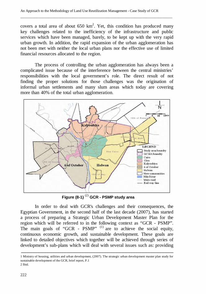
covers a total area of about 650 km2. Yet, this condition has produced many
key challenges related to the inefficiency of the infrastructure and public
services which have been managed, barely, to be kept up with the very rapid
urban growth. In addition, the rapid expansion of the urban agglomeration has
not been met with neither the local urban plans nor the effective use of limited
financial resources allocated to the region.
The process of controlling the urban agglomeration has always been a
complicated issue because of the interference between the central ministries’
responsibilities with the local government’s role. The direct result of not
finding the proper solutions for those challenges was the origination of
informal urban settlements and many slum areas which today are covering
more than 40% of the total urban agglomeration.
In order to deal with GCR's challenges and their consequences, the
Egyptian Government, in the second half of the last decade (2007), has started
a process of preparing a Strategic Urban Development Master Plan for the
region which will be referred to in the following context as “GCR - PSMP”.
The main goals of “GCR - PSMP” )1( are to achieve the social equity,
continuous economic growth, and sustainable development. These goals are
linked to detailed objectives which together will be achieved through series of
development’s sub-plans which will deal with several issues such as: providing
ــــــ ــــــــــــــ ــــــــــ ــــــــــــــ ــــــــــ ـــــــــــ ـــ ــــــــــــــــــ ـــ ـــــــــــ ــــــــــ ــــــــــــــ ــــــــــ ــــــــــ ـــــــــــ ـــ ــــــــــــــــــ ـــ ـــــ1 Ministry of housing, utilities and urban development, (2007). The strategic urban development master plan study for
sustainable development of the GCR, brief report, P.1
2 Ibid.
Figure (8-1) (2)
GCR - PSMP study area
Chapter 8 – GCR Strategic Master Plan – Vision, Mission, and organizational strategic objectives towards
land use reutilization
____________________________________________________________________________
223
well-balanced urban development, providing decent housing alternatives,
developing more urban facilities and public services, considering the
economical approach and the required huge investments. All these
development’s sub-plans will be implemented within “GCR - PSMP” by
determining and managing a set of portfolios, programs, and projects. Figure
(8-1) illustrates the boundaries of GCR - PSMP’s study area (Greater Cairo
Metropolitan Area “GCMA”) with an extent of 4367 Km2.
8.2 GCR - PSMP : VISION AND MISSION
As described in Chapter Three, the vision is long-term view,
concentrating on the future, where the Mission provides the details of what
shall be done to achieve the Vision. GCR - PSMP vision and mission have
been defined by GOPP as follows )1(:
GCR - PSMP VISION: Enhance the rank of Cairo as a "Global City" to be
prime urban destination in the Arab World and Middle East.
GCR - PSMP MISSION: Restore Cairo to be a better city for all the people to
live in, a prosperous metropolis with strong and diverse economic activities,
well-balanced urban developments, environmentally more friendly and well
planned city.
8.3 GCR - PSMP : ORGANIZATIONAL STRATEGY AND OBJECTIVES
The long term goal of GCR - PSMP is to contribute to sustainable urban
development of the GCR and increase its competitiveness through achieving a
number of impacts, such as, strengthening the global linkages and integration
between the existing urban built-up area and the new urban communities,
defining the economic role and the competitive economic clusters of the region
to leverage their potentials, increasing the efficiency of managing the region,
and consolidating the active participation of key stakeholders in the decision
making and planning process through a strategic planning approach. The time
horizon for the plan is the year 2050 but will start with a short/medium-term
action plan involving the following key activities )2(:
• Develop upgrading plans for the existing slums and illegal settlements within
the region and surround them with newly planned areas to prevent their
illegal expansion.
ــــــــ ــــــــــــــ ـــ ـــــــــــ ــــــــــ ـــــــــــ ـــ ـــــــــــــــــــــ ـــ ــــــــــــــــــ ـــ ـــــــــــ ــــــــــــــــــــ ـــــــــــ ـــ ــــــــــــــــــ ـــ ـــــــــــ ــ1 Ministry of housing, utilities and urban development, (2007). Existing situation and proposed land use of the Greater
Cairo Region, 1St seminar report, P. 2
2 Ibid., P. 16

An Approach to the Methodology of Land Use Reutilization Management - Case Study of GCR
____________________________________________________________________________
224
• Transfer the Ministries and Governmental buildings from the old inner city
center to a new governmental center at the peripheries of the region.
• Relocate of the polluting land-uses outside the inner city.
• Developing a new strategic plan for traffic and transportation.
• Developing a new master plan for the infrastructure.
• Developing an integrated Local Economic Development Strategy to improve
the region's competitiveness.
• Revitalization of Historical Centers within the region.
The Egyptian Government represented by GOOP who has built GCR - PSMP’s
organizational strategy to define how the vision and mission will be achieved.
Consequently, GCR - PSMP’s organizational strategy has defined the
objectives which OPM methodology could deal with through performing a set
of prioritized portfolios, programs and projects to attain. GCR - PSMP’s
organizational strategy has been categorized under five main themes where
each theme contains some objectives as follows )1(:
• Living in Cairo.
• Working in Cairo.
• Connecting in Cairo.
• Managing the natural environment.
• Designing a sustainable city.
8.3.1 LIVING IN CAIRO
The following two main objectives are linked to “Living in Cairo” as one of the
themes of GCR - PSMP’s organizational strategies.
• Providing housing supply for various household groups.
• Improving the living environment of slum areas.
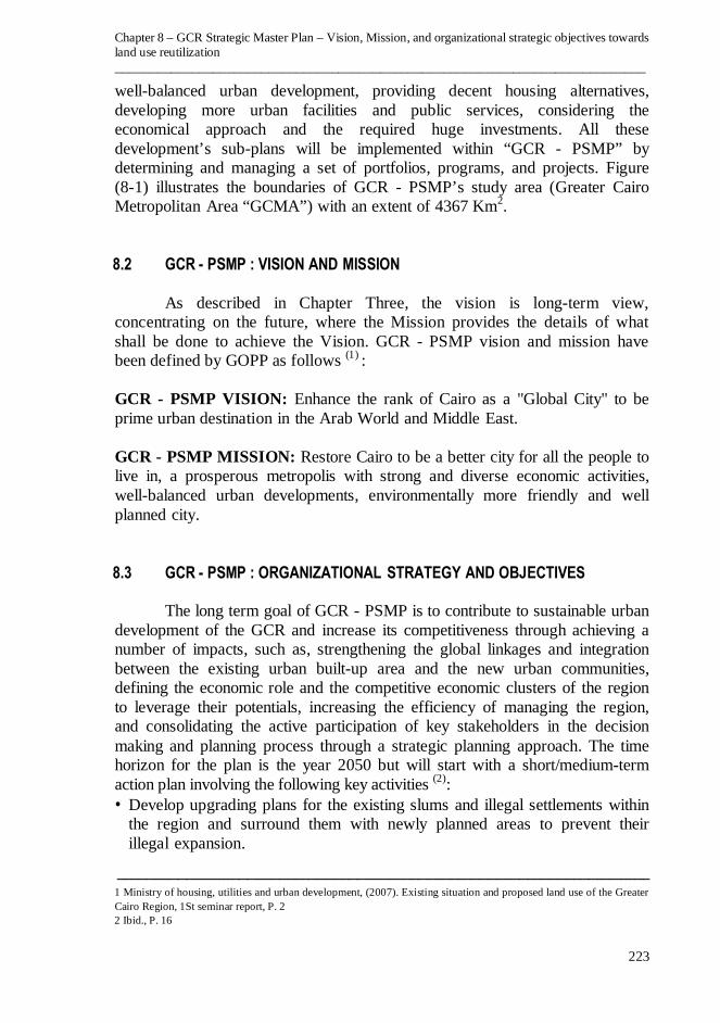
Accordingly, and based on GCR - PSMP studies of existing conditions
which show that about 70% of the total housing demand are from low income
group and suggest that mobilizing of unused housing units and adjusting
housing supply by different income groups, four pilot areas were selected for
the improvement purpose of the slum areas – as illustrated in figure (8-2) )2(.
Area (A) : adjacent to proposed relocated factories in Shobra Al-Khemah.
Area (B) : adjacent to proposed redevelopment area at north of Giza City.
Area (C) : adjacent to tourist zone at Pyramids Area.
Area (D) : within the cemetery zone at the East of Cairo.
ــــــ ــــــــــــــ ــــــــــ ــــــــــــــ ــــــــــ ـــــــــــ ـــ ــــــــــــــــــ ـــ ـــــــــــ ــــــــــ ــــــــــــــ ــــــــــ ــــــــــ ـــــــــــ ـــ ــــــــــــــــــ ـــ ـــــ1 Ibid., P. 12-15
2 Ibid., P. 13
Chapter 8 – GCR Strategic Master Plan – Vision, Mission, and organizational strategic objectives towards
land use reutilization
____________________________________________________________________________
225
8.3.2 WORKING IN CAIRO.
The following three main objectives are linked to “working in Cairo” as one of
the themes of GCR - PSMP’s organizational strategies.
1
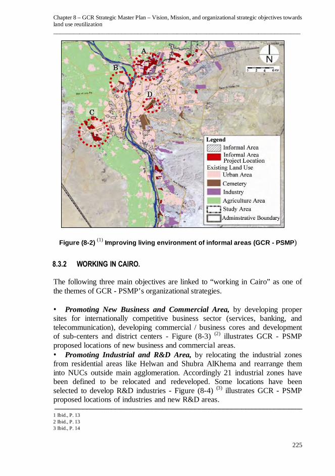
• Promoting New Business and Commercial Area, by developing proper
sites for internationally competitive business sector (services, banking, and
telecommunication), developing commercial / business cores and development
of sub-centers and district centers - Figure (8-3) )2( illustrates GCR - PSMP
proposed locations of new business and commercial areas.
• Promoting Industrial and R&D Area, by relocating the industrial zones
from residential areas like Helwan and Shubra AlKhema and rearrange them
into NUCs outside main agglomeration. Accordingly 21 industrial zones have
been defined to be relocated and redeveloped. Some locations have been
selected to develop R&D industries - Figure (8-4) )3( illustrates GCR - PSMP
proposed locations of industries and new R&D areas. ــــــــ ــــــــــــــ ـــ ـــــــــــ ــــــــــ ـــــــــــ ـــ ـــــــــــــــــــــ ـــ ــــــــــــــــــ ـــ ـــــــــــ ــــــــــــــــــــ ـــــــــــ ـــ ــــــــــــــــــ ـــ ـــــــــــ ــ
1 Ibid., P. 13
2 Ibid., P. 13
3 Ibid., P. 14
Figure (8-2) (1)
Improving living environment of informal areas (GCR - PSMP)
An Approach to the Methodology of Land Use Reutilization Management - Case Study of GCR
____________________________________________________________________________
226
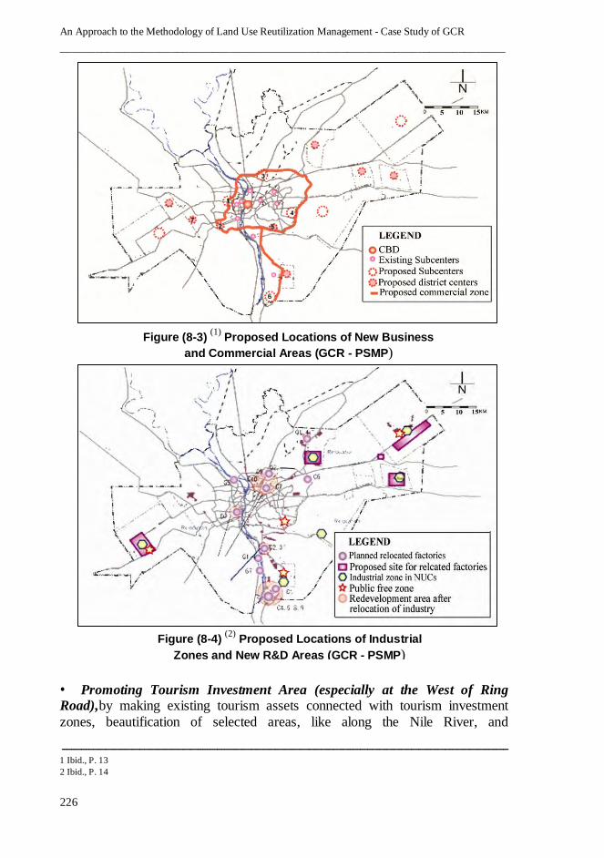
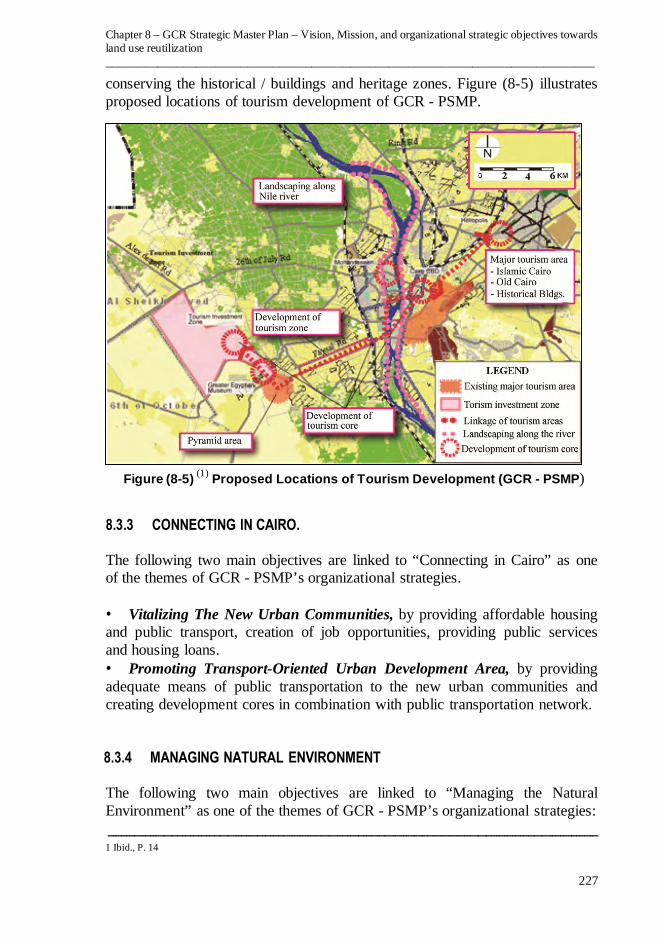
• Promoting Tourism Investment Area (especially at the West of Ring Road),1by making existing tourism assets connected with tourism investment
zones, beautification of selected areas, like along the Nile River, and
ــــــ ــــــــــــــ ــــــــــ ــــــــــــــ ــــــــــ ـــــــــــ ـــ ــــــــــــــــــ ـــ ـــــــــــ ــــــــــ ــــــــــــــ ــــــــــ ــــــــــ ـــــــــــ ـــ ــــــــــــــــــ ـــ ـــــ1 Ibid., P. 13
2 Ibid., P. 14
Figure (8-4) (2)
Proposed Locations of Industrial
Zones and New R&D Areas (GCR - PSMP)
Figure (8-3) (1)
Proposed Locations of New Business
and Commercial Areas (GCR - PSMP)
Chapter 8 – GCR Strategic Master Plan – Vision, Mission, and organizational strategic objectives towards
land use reutilization
____________________________________________________________________________
227
conserving the historical / buildings and heritage zones. Figure (8-5) 1illustrates
proposed locations of tourism development of GCR - PSMP.
8.3.3 CONNECTING IN CAIRO.
The following two main objectives are linked to “Connecting in Cairo” as one
of the themes of GCR - PSMP’s organizational strategies.
• Vitalizing The New Urban Communities, by providing affordable housing
and public transport, creation of job opportunities, providing public services
and housing loans.
• Promoting Transport-Oriented Urban Development Area, by providing
adequate means of public transportation to the new urban communities and
creating development cores in combination with public transportation network.
8.3.4 MANAGING NATURAL ENVIRONMENT
The following two main objectives are linked to “Managing the Natural
Environment” as one of the themes of GCR - PSMP’s organizational strategies:
ــــــــ ــــــــــــــ ـــ ـــــــــــ ــــــــــ ـــــــــــ ـــ ـــــــــــــــــــــ ـــ ــــــــــــــــــ ـــ ـــــــــــ ــــــــــــــــــــ ـــــــــــ ـــ ــــــــــــــــــ ـــ ـــــــــــ ــ1 Ibid., P. 14
Figure (8-5) (1)
Proposed Locations of Tourism Development (GCR - PSMP)
An Approach to the Methodology of Land Use Reutilization Management - Case Study of GCR
____________________________________________________________________________
228
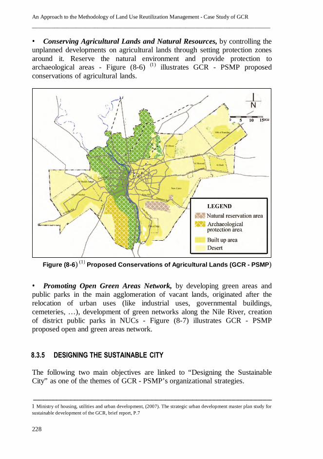
• Conserving Agricultural Lands and Natural Resources, by controlling the
unplanned developments on agricultural lands through setting protection zones
around it. Reserve the natural environment and provide protection to
archaeological areas - Figure (8-6) )1( illustrates GCR - PSMP proposed
conservations of agricultural lands.
• Promoting Open Green Areas Network, by developing green areas and
public parks in the main agglomeration of vacant lands, originated after the
relocation of urban uses (like industrial uses, governmental buildings,
cemeteries, …), development of green networks along the Nile River, creation
of district public parks in NUCs - Figure (8-7) illustrates GCR - PSMP
proposed open and green areas network.
8.3.5 DESIGNING THE SUSTAINABLE CITY
The following two main objectives are linked to “Designing the Sustainable
City” as one of the themes of GCR - PSMP’s organizational strategies.
ــــــ ــــــــــــــ ــــــــــ ــــــــــــــ ــــــــــ ـــــــــــ ـــ ــــــــــــــــــ ـــ ـــــــــــ ــــــــــ ــــــــــــــ ــــــــــ ــــــــــ ـــــــــــ ـــ ــــــــــــــــــ ـــ ـــــ1 Ministry of housing, utilities and urban development, (2007). The strategic urban development master plan study for
sustainable development of the GCR, brief report, P.7
Figure (8-6) (1)
Proposed Conservations of Agricultural Lands (GCR - PSMP)

Chapter 8 – GCR Strategic Master Plan – Vision, Mission, and organizational strategic objectives towards
land use reutilization
____________________________________________________________________________
229
1
ــــــــ ــــــــــــــ ـــ ـــــــــــ ــــــــــ ـــــــــــ ـــ ـــــــــــــــــــــ ـــ ــــــــــــــــــ ـــ ـــــــــــ ــــــــــــــــــــ ـــــــــــ ـــ ــــــــــــــــــ ـــ ـــــــــــ ــ1 Ministry of housing, utilities and urban development, (2007). Existing situation and proposed land use of the Greater
Cairo Region, 1St seminar report, P. 15
2 Ministry of housing, utilities and urban development, (2007). The strategic urban development master plan study for
sustainable development of the GCR, brief report, P.6
Figure (8-7) (1)
Proposed Open and Green Areas Network (GCR - PSMP)
Figure (8-8) (2)
Existing and Future Urban Development Area (GCR - PSMP)
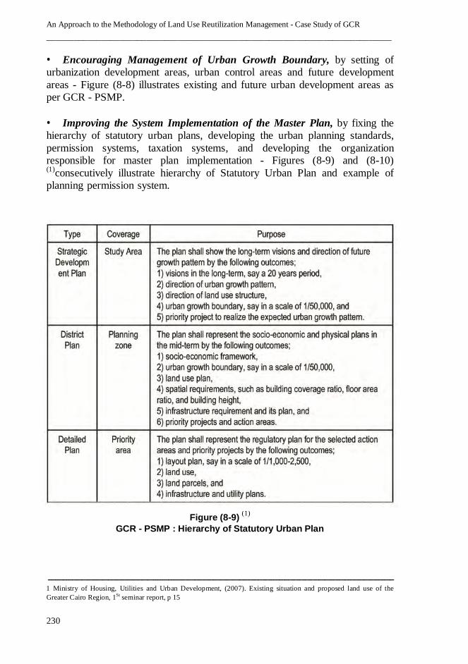
An Approach to the Methodology of Land Use Reutilization Management - Case Study of GCR
____________________________________________________________________________
230
• Encouraging Management of Urban Growth Boundary, by setting of
urbanization development areas, urban control areas and future development
areas - Figure (8-8) illustrates existing and future urban development areas as
per GCR - PSMP.
• Improving the System Implementation of the Master Plan, by fixing the
hierarchy of statutory urban plans, developing the urban planning standards,
permission systems, taxation systems, and developing the organization
responsible for master plan implementation - Figures (8-9) and (8-10) )1(consecutively illustrate hierarchy of Statutory Urban Plan and example of
planning permission system.
ــــــ ــــــــــــــ ــــــــــ ــــــــــــــ ــــــــــ ـــــــــــ ـــ ــــــــــــــــــ ـــ ـــــــــــ ــــــــــ ــــــــــــــ ــــــــــ ــــــــــ ـــــــــــ ـــ ــــــــــــــــــ ـــ ـــــ1 Ministry of Housing, Utilities and Urban Development, (2007). Existing situation and proposed land use of the
Greater Cairo Region, 1St seminar report, p 15
Figure (8-9) (1)
GCR - PSMP : Hierarchy of Statutory Urban Plan
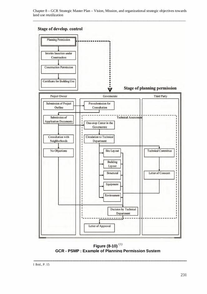
Chapter 8 – GCR Strategic Master Plan – Vision, Mission, and organizational strategic objectives towards
land use reutilization
____________________________________________________________________________
231
1
ــــــــ ــــــــــــــ ـــ ـــــــــــ ــــــــــ ـــــــــــ ـــ ـــــــــــــــــــــ ـــ ــــــــــــــــــ ـــ ـــــــــــ ــــــــــــــــــــ ـــــــــــ ـــ ــــــــــــــــــ ـــ ـــــــــــ ــ1 Ibid., P. 15
Figure (8-10) (1)
GCR - PSMP : Example of Planning Permission System
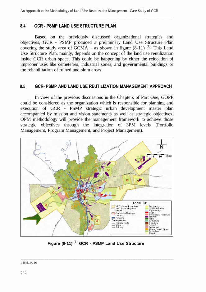
An Approach to the Methodology of Land Use Reutilization Management - Case Study of GCR
____________________________________________________________________________
232
8.4 GCR - PSMP LAND USE STRUCTURE PLAN
Based on the previously discussed organizational strategies and
objectives, GCR - PSMP produced a preliminary Land Use Structure Plan
covering the study area of GCMA – as shown in figure (8-11) )1(. This Land
Use Structure Plan, mainly, depends on the concept of the land use reutilization
inside GCR urban space. This could be happening by either the relocation of
improper uses like cemeteries, industrial zones, and governmental buildings or
the rehabilitation of ruined and slum areas.
8.5 GCR- PSMP AND LAND USE REUTILIZATION MANAGEMENT APPROACH
In view of the previous discussions in the Chapters of Part One, GOPP
could be considered as the organization which is responsible for planning and
execution of GCR - PSMP strategic urban development master plan
accompanied by mission and vision statements as well as strategic objectives.
OPM methodology will provide the management framework to achieve those
strategic objectives through the integration of 3PM levels (Portfolio
Management, Program Management, and Project Management).
ــــــ ــــــــــــــ ــــــــــ ــــــــــــــ ــــــــــ ـــــــــــ ـــ ــــــــــــــــــ ـــ ـــــــــــ ــــــــــ ــــــــــــــ ــــــــــ ــــــــــ ـــــــــــ ـــ ــــــــــــــــــ ـــ ـــــ1 Ibid., P. 16
Figure (8-11) (1)
GCR - PSMP Land Use Structure
Chapter 8 – GCR Strategic Master Plan – Vision, Mission, and organizational strategic objectives towards
land use reutilization
____________________________________________________________________________
233
The portfolio, the higher level of 3PM, links the organizational strategy
to a set of prioritized programs and projects, addresses the relevant internal and
external business drivers’ references as objectives in GCR - PSMP. The
ultimate goal of linking portfolio management with organizational strategy is to
establish a balanced, executable plan which will help GOPP to achieve GCR -
PSMP objectives.
GCR - PSMP has defined, tentatively, 52 programs and projects which
need to be managed to achieve the determined objectives. Figures (8-12) )1( and
(8-13) )2( illustrate GCR - PSMP programs & projects defined by GOPP. The
thesis will classify those programs and projects based on their interrelationship
with land use reutilization processes into three groups, as follows:
• Programs & Projects with direct relation to the land use reutilization
processes “12 programs and projects shown in figures (8-12) and (8-13)
with beige background color”.
• Programs & Projects with indirect relation to the land use reutilization
processes “10 programs and projects shown in figures (8-12) and (8-13)
with yellow background color”.
• Programs & Projects with no relation to the land use reutilization processes
“shown in figures (8-12) and (8-13) with white background color”.
Accordingly, 22 programs and projects, out of total 52 GCR - PSMP
programs and projects, are related directly or indirectly to the land use
reutilization activities. Based on this relative importance, the thesis will
hypothesize the existence of stand-alone portfolio of GCR land use
reutilization which include those 22 programs and projects within 3PM context
and hence will examine how they could be managed by integral manner using
OPM methodology.
ــــــــ ــــــــــــــ ـــ ـــــــــــ ــــــــــ ـــــــــــ ـــ ـــــــــــــــــــــ ـــ ــــــــــــــــــ ـــ ـــــــــــ ــــــــــــــــــــ ـــــــــــ ـــ ــــــــــــــــــ ـــ ـــــــــــ ــ1 Ministry of housing, utilities and urban development, (2007). Existing situation and proposed land use of the Greater
Cairo Region, 1St seminar report, P. 16
2 Ibid., P. 16
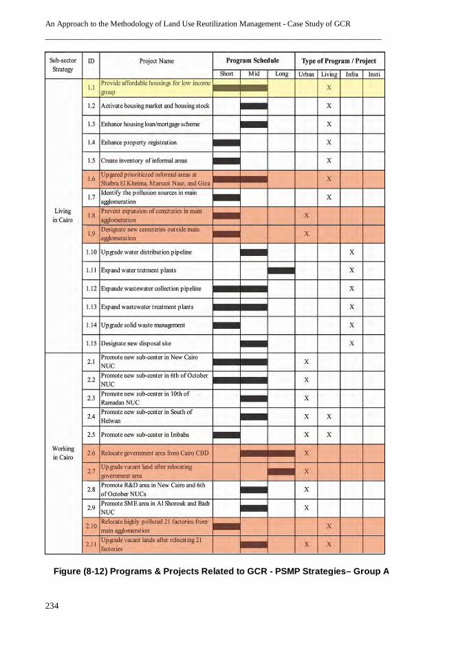
An Approach to the Methodology of Land Use Reutilization Management - Case Study of GCR
____________________________________________________________________________
234
Figure (8-12) Programs & Projects Related to GCR - PSMP Strategies– Group A
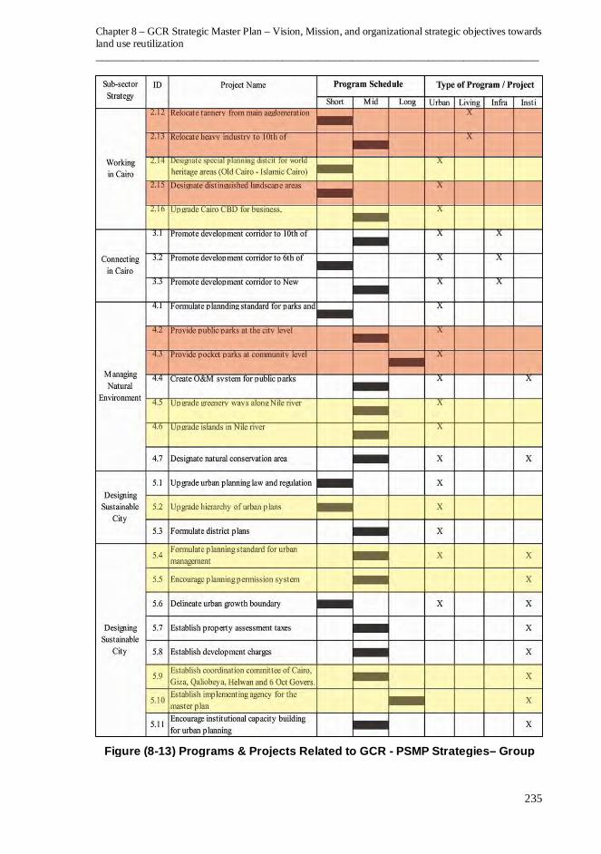
Chapter 8 – GCR Strategic Master Plan – Vision, Mission, and organizational strategic objectives towards
land use reutilization
____________________________________________________________________________
235
Figure (8-13) Programs & Projects Related to GCR - PSMP Strategies– Group B

An Approach to the Methodology of Land Use Reutilization Management - Case Study of GCR
____________________________________________________________________________
236
In general, GCR - PSMP programs and projects could be classified
under a number of portfolios which could be managed in an integrated context
of analogous programs and projects, the thesis would propose those portfolios
as follows:
• The Portfolio of GCR land use reutilization.
• The Portfolio of developing GCR services, utilities and infrastructure.
• The Portfolio of developing NUCs and development corridors.
• The Portfolio of human development of GCR residents.
• The Portfolio of building science and technology national base in GCR.
• The Portfolio of developing GCR natural and economic resources.
In particular, the thesis will deal with the proposed portfolio of GCR
land use reutilization and will consider the 22 programs and projects which are
defined by GOPP in GCR - PSMP. The thesis will propose a number of
programs under the portfolio of GCR land use reutilization, as follows:
• The Program of land use reutilization of cemeteries inside GCR urban
space.
• The Program of land use reutilization of ruined / slum areas.
• The Program of land use reutilization of ministries and governmental
buildings.
• The Program of land use reutilization of industrial zones inside GCR urban
space.
• The Program of land use reutilization of transportation and traffic uses.
• The Program of land use reutilization of miscellaneous uses.
Each program will include a number of related projects. For example:
the program of land use reutilization of cemeteries involves the relocation of
the cemeteries which are inside GCR urban space, including 1400 Acres of
cemetery along Salah Salem Road and many other cemeteries in different
locations. Two new locations have been assigned by the Egyptian Government
to relocate the old cemeteries to establish new ones. The first location, with
area of about 5000 Acre (21 million m2), is set along the Oasis Road in 6
th of
October City and has a capacity of three hundred thousand cemeteries. The
second location, with area of about 12000 Acres (50.4 million m2), is set along
the Katamia – Ain Sokhna Road in Helwan City and has a capacity of 700
thousand tombs.
Chapter 8 – GCR Strategic Master Plan – Vision, Mission, and organizational strategic objectives towards
land use reutilization
____________________________________________________________________________
237
The program of land use reutilization of cemeteries inside GCR urban
space may include the following projects:
• The Project of land use reutilization of the cemeteries between Autostrade
and Salah Salem Roads.
• The Project of land use reutilization of the cemeteries at West side of Salah
Salem Road.
• The Project of land use reutilization of Shubra Cemeteries.
• The Project of land use reutilization of Al-Waily District Cemeteries.
• The Project of land use reutilization of Al-Gamalia District Cemeteries.
• The Project of land use reutilization of Al-Darb Al-Ahmar District
Cemeteries.
• The Project of land use reutilization of Al-Khalifa District Cemeteries.
• The Project of land use reutilization of Al-Sayeda Zainab District
Cemeteries.
• The Project of land use reutilization of Masr Al-Kadema District
Cemeteries.
8.6 EPILOGUE
• In order to deal with GCR challenges and their consequences, the
Egyptian Government has recently started a process of preparing a
Proposed Strategic Master Plan for the region (GCR - PSMP).
• GCR - PSMP Vision is to enhance the rank of Cairo as a "Global City" to
be prime urban destination in the Arab World and Middle East.
• GCR - PSMP Mission is to restore Cairo to be a better city for all the
people to live in, a prosperous metropolis with strong and diverse
economic activities, well-balanced urban developments, environmentally
more friendly and well planned city.
• GCR - PSMP Organizational Strategy consists of five main themes:
living in Cairo, working in Cairo, connecting in Cairo, managing the
natural environment, designing a new sustainable city.
• The theme of “Living in Cairo” has two main objectives: providing
housing supply for various household groups, and improving the living
environment of slum areas.
• The theme of “Working in Cairo” has three main objectives: promoting
new business and commercial area, promoting industrial and R&D area,
and promoting tourism investment area (especially at the west of the ring
road).

An Approach to the Methodology of Land Use Reutilization Management - Case Study of GCR
____________________________________________________________________________
238
• The theme of “Connecting in Cairo” has two main objectives: vitalizing
the new urban communities, and promoting transport-oriented urban
development area.
• The theme of “Managing Natural Environment” has two main objectives:
conserving agricultural lands and natural resources, and promoting open
and green area network.
• The theme of “Designing a Sustainable City” has two main objectives:
encouraging management of urban growth boundary, and improving of
the implementation system of the master plan.
• GCR - PSMP has produced a preliminary land use structure plan which
depends on the concept of land use reutilization inside GCR urban space.
• GCR - PSMP has defined, tentatively, 52 programs and projects which
need to be managed to achieve the determined objectives which could be
classified, based on their interrelationship with land use reutilization, into
three groups as follows: direct relation, indirect relation, no relation.
• 22 programs and projects out of total 52 GCR - PSMP Programs and
Projects are related directly or indirectly to land use reutilization
activities. The thesis will hypothesize the existence of stand-alone
portfolio of GCR land use reutilization which includes these 22 programs
and portfolios within 3PM context and will examine how they could be
managed by integral manner, using OPM methodology.
• The thesis proposes six programs which are included under the portfolio
of GCR land use reutilization.
• Each program will include a number of related projects.