landscape planning paper 2015
DESCRIPTION
This publication documents the work elaborated by 42 international students from Denmark and the world. For 8 weeks they have worked with the transformation of a territory we have called Zydhavn. With Zydhavn the aim is to envision, plan and to design for a future urban territory of Sydhavn in the south-western part of Copenhagen. Like some strange world – a very long experimental garden the Zydhavn projects connect: Sjælør Boulevard, Vestre Kikegård, Karens Minde, the allotment gardens on both sides of the railway tracks and Tippen by the waters of Kalvebodløbet. The Landscape design course is part of the masters program at The University of Copenhagen.TRANSCRIPT

d e pa rt m e n t o f g e o s c i e n c e s a n d n at u r a l re s o u rc e m a n ag e m e n tu n i ve r s i t y o f co pe n h ag e n
Landscape Planning Studio 2015
ZYDHAVNA territory in Sydhavn

The Studio 2015
Teaching team Editorial team
Layout
Special thanks to:
Peter Lundsgaard Hansen – course responsible and workspace curatorEllen M. BraaeTorben E. Dam Jens Linnet Martin Lysholm Hjerl Carsten Johansen (ModelLab)
Sofie BrinckerPeter Lundsgaard Hansen
Sofie BrinckerJette Alsing Larsen
GEORG BOYES FONDThanks to Georg Boyes Fond for the grant to support the fieldwork in France, Belgium and Germany.
THE MUNICIPALITY OF COPENHAGENThanks to Emilie Flak Barkved for talking to us in the studio
COLLEAUGESWe are grateful for the stimulating walks, talks, lectures and discussions with our fellow colleagues from landscape architecture offices and from The University of Copenhagen. Lastly a speciel thanks to Belgian Landscape architech Koen Hauspy and the office LAND landschapsarchitecten for all the help.
Andrews, Sophie Louise
Blicher, Mette
Broberg, Troels Sindballe
Bulath, Johanna Eszter
Burr, Maria Skytt
Bøye, Cecilie
Carstensen, Mira Theil
Dehlsen, Mie Højmose
Drummond, Clare
Fallah, Muzdah
Frelin, Ander Oskar
Friis, Isabella Lindeschouw
Haslev, Ditte
Hesselholdt, Jesper
Holm, Jens Hansen
Hopps, Inge Borregaard Pedersen
Husum, Hanna Grimsrud
Jakobsen, Pernille Sidelmann
Jensen, Cathrine Tankmar Juhl
Jessen, Naja
Jolly, Leo
Kalsi, Sheila
Krebs, Michala Kaja
Larsen, Trine
Lassen, Rasmus Bundgaard
Madsen, Troels Øgaard
Møller, Frederikke Fossum Thurø
Nordow, Mia
O’Connell, Gerard William
Palmgren-Salomonsson, Jon
Pedersen, Hans Bruun
Rasmussen, Nichlas Claus
Rousting, Nicolai Bülow
Sanfridsson, Karin Johanna
Schmidt-Petersen, Kit
Silvano, Leonor
Skajaa, Julie
Steengaard, Annabell Wallin
Sørensen, Marianne Grønkjær
Vandendungen, Mark
Vehabovic, Amra
Østergaard, Nanna Maj Stubbe
l a n d s c a p e p l a n n i n g 2 0 1 5 • pa g e 2u n i v e r s i t y o f c o p e n h a g e n

INTROThis publication documents the work elaborated by 42 international students from Denmark and the world. For 8 weeks they have worked with the trans-formation of a territory we have called Zydhavn. With Zydhavn the aim is to envision, plan and to design for a future urban territory of Sydhavn in the south-western part of Copenhagen. Like some strange world – a very long ex-perimental garden the Zydhavn projects connect: Sjælør Boulevard, Vestre Kikegård, Karens Minde, the allotment gardens on both sides of the railway tracks and Tippen by the waters of Kalvebodløbet. The Landscape design course is part of the masters program at The University of Copenhagen.


Table of Contents
Introduction
Group projects
Colophon
Intro
Table of Contents
Zydhavn
The way we work I
The way we work II
The way we work III
The way we work IV
Karens Minde ParkenGroup 1
Connecting WatersGroup 2
Concrete SymphonyGroup 3
Zydhavnen Join[t]Group 4
Sydhavn BoulelifeGroup 5
Linking LandscapesGroup 6
Stepping into SydhavnenGroup 7
ZYD WAYGroup 8
The Green LineGroup 9
The Zydhavn WayGroup 10
2
3
5
6
9
12
13
14
20
22
24
26
28
30
32
34
36
38
l a n d s c a p e p l a n n i n g 2 0 1 5 • pa g e 5u n i v e r s i t y o f c o p e n h a g e n
By Peter Lundsgaard Hansen
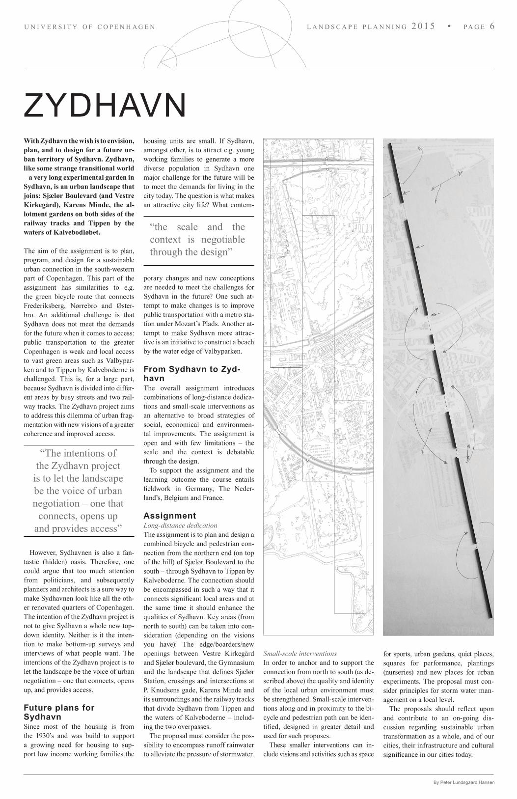
ZYDHAVNWith Zydhavn the wish is to envision, plan, and to design for a future ur-ban territory of Sydhavn. Zydhavn, like some strange transitional world – a very long experimental garden in Sydhavn, is an urban landscape that joins: Sjælør Boulevard (and Vestre Kirkegård), Karens Minde, the al-lotment gardens on both sides of the railway tracks and Tippen by the waters of Kalvebodløbet.
The aim of the assignment is to plan, program, and design for a sustainable urban connection in the south-western part of Copenhagen. This part of the assignment has similarities to e.g. the green bicycle route that connects Frede riksberg, Nørrebro and Øster-bro. An additional challenge is that Sydhavn does not meet the demands for the future when it comes to access: public transportation to the greater Copenhagen is weak and local access to vast green areas such as Valbypar-ken and to Tippen by Kalveboderne is challenged. This is, for a large part, because Sydhavn is divided into differ-ent areas by busy streets and two rail-way tracks. The Zydhavn project aims to address this dilemma of urban frag-mentation with new visions of a greater coherence and improved access.
However, Sydhavnen is also a fan-tastic (hidden) oasis. Therefore, one could argue that too much attention from politicians, and subsequently planners and architects is a sure way to make Sydhavnen look like all the oth-er renovated quarters of Copenhagen. The intention of the Zydhavn project is not to give Sydhavn a whole new top-down identity. Neither is it the inten-tion to make bottom-up surveys and interviews of what people want. The intentions of the Zydhavn project is to let the landscape be the voice of urban negotiation – one that connects, opens up, and provides access.
Future plans for SydhavnSince most of the housing is from the 1930’s and was build to support a growing need for housing to sup-port low income working families the
housing units are small. If Sydhavn, amongst other, is to attract e.g. young working families to generate a more diverse population in Sydhavn one major challenge for the future will be to meet the demands for living in the city today. The question is what makes an attractive city life? What contem-
porary changes and new conceptions are needed to meet the challenges for Sydhavn in the future? One such at-tempt to make changes is to improve public transportation with a metro sta-tion under Mozart’s Plads. Another at-tempt to make Sydhavn more attrac-tive is an initiative to construct a beach by the water edge of Valbyparken.
From Sydhavn to ZydhavnThe overall assignment introduces combinations of long-distance dedica-tions and small-scale interventions as an alternative to broad strategies of social, economical and environmen-tal improvements. The assignment is open and with few limitations – the scale and the context is debatable through the design.
To support the assignment and the learning outcome the course entails fieldwork in Germany, The Neder-land’s, Belgium and France.
AssignmentLong-distance dedicationThe assignment is to plan and design a combined bicycle and pedestrian con-nection from the northern end (on top of the hill) of Sjælør Boulevard to the south – through Sydhavn to Tippen by Kalveboderne. The connection should be encompassed in such a way that it connects significant local areas and at the same time it should enhance the qualities of Sydhavn. Key areas (from north to south) can be taken into con-sideration (depending on the visions you have): The edge/boarders/new openings between Vestre Kirkegård and Sjælør boulevard, the Gymnasium and the landscape that defines Sjælør Station, crossings and intersections at P. Knudsens gade, Karens Minde and its surroundings and the railway tracks that divide Sydhavn from Tippen and the waters of Kalveboderne – includ-ing the two overpasses.
The proposal must consider the pos-sibility to encompass runoff rainwater to alleviate the pressure of stormwater.
Small-scale interventionsIn order to anchor and to support the connection from north to south (as de-scribed above) the quality and identity of the local urban environment must be strengthened. Small-scale interven-tions along and in proximity to the bi-cycle and pedestrian path can be iden-tified, designed in greater detail and used for such proposes.
These smaller interventions can in-clude visions and activities such as space
“The intentions of the Zydhavn project
is to let the landscape be the voice of urban negotiation – one that
connects, opens up and provides access”
“the scale and the context is negotiable through the design”
for sports, urban gardens, quiet places, squares for performance, plantings (nurseries) and new places for urban experiments. The proposal must con-sider principles for storm water man-agement on a local level.
The proposals should reflect upon and contribute to an on-going dis-cussion regarding sustainable urban transformation as a whole, and of our cities, their infrastructure and cultural significance in our cities today.
l a n d s c a p e p l a n n i n g 2 0 1 5 • pa g e 6u n i v e r s i t y o f c o p e n h a g e n
l a n d s c a p e p l a n n i n g 2 0 1 5 • pa g e 7u n i v e r s i t y o f c o p e n h a g e n


The way we work is by repeating the same model and drawings through-out the course. We do this while we talk, travel, listen, read, draw and evaluate. We have a workspace – the campfire – where we sample, collect, exhibit and where we share ideas. The theory behind the way we work is based on the reality of our studios where collective design is common practice. This challenges communica-tion and the sharing of ideas among designers within the design process. In order to create meaningful conver-sations we have created a workspace – the campfire – where we collect, sample, build, draw, refer, project and discuss to strengthen the ability to see, respectively and by mutual interac-tion.
The campfire workspace is an exhi-bition architecture we curate for en-hancing creative consciousness among the design actors. It enables our abil-ity to see by means of its display of an exhibition-like space and it helps us navigate in the design process. Fi-nally the method connects the design progress to conscious scriptwriting of spatial form.
When we work with models and drawings they never exactly look alike. This is because they are feeding off of each other (through us) – one al-ways making the other adjust a little.
The methodWe use Google earth, maps, film and other representative medias to recreate the territory of Zydhavn. We will build analogue models (we will build them in our Model Lab) of Zydhavn and of reference studies when we travel. Dur-ing the building of the models, we will rate qualities of the urban landscape and the possibilities of new develop-ment as qualified as possible.The big model (the context model) will have a hole where we test and develop our ideas. The hole determines part of the project site.
During our work with the design we use the walls and floors of the school to exhibit our work in progress. The exhibition wall is where we meet our imaginary client and where we let go of our fear of showing all the mistakes we have to make before we are satis-fied with the result.
The way we work I
The workspace when we travel – in this case – in Kasterlee, Belgium.
Vertical projection, models, and hand drawings are combined when we work in the studio.
When we work in the studio we feed off models so to speak, because the movement we create makes us able to engage in our work. It is similar to that of working with a crimescene. In plan-ning we call the motive; issues (pro-blem formulation) and the scene of the crime; the site.
The observations we make when we work we document, evaluate, and talk about. When we work in the campfire workspace new observations can look like little mistakes because they of-ten show themselves in a drawing or a model as something that just doesn’t fit in the big picture. So look out for them!
Besides working digital we work with two types of different models. Simple modelsThere is a substantial advantages in building simple physical models. The
investigative and inquisitive models have a central role in the process of analysis and design. They empower the sharing of ideas, concepts and pro-gramming. We repeat the simple mod-el again and again.
Abstract modelThe first (and often the last) model we work with when we engage and try to understand our own work or other works of landscape architecture is even more simple. The model is abstract and we carry it with us in a model box. We can build this type of model anywhere.
Big modelIn order to strengthen and qualify the way we discuss and evaluate our work in the context of a greater urban landscape we use a big model to test our arguments by putting our simple
concept models in a big context model. We then repeat the process while we work on our digital plans, visualiza-tions, sections, text and so forth.
Vertical projectionThe duct tape zone in Versailles is one place where we work with vertical projection. This allows us to project digital drawings, film medial, histori-cal maps onto the floor of the studio, the Big Model or onto a light table. We then work directly on the floor, the model or the table. When we are satis-fied whit what we have, we can take a picture of the plan and go back to work outside the duct tape zone.
To read more about the way we workwww.fusion-journal.com/issue/003-fusion-the-studio/the-simple-model-method-creating-steep-learning-curves-in-academic-design-studio/
“Models and drawings they never exactly
look alike. This is be-cause they are feeding
off of each other”
By Peter Lundsgaard Hansen
l a n d s c a p e p l a n n i n g 2 0 1 5 • pa g e 9u n i v e r s i t y o f c o p e n h a g e n

By the way we combine drawings and models we aim to provide a platform for students, supervisors and other involved actors for the exchange of ideas and experi-ence – individually and in groups – and for a solution focusing strategy. Lastly, the method facilitates a key aim of the design studios: to increase the student’s ability to translate physical form (the model being a non-verbal agent) into a spoken language (creating an explicit awareness).
l a n d s c a p e p l a n n i n g 2 0 1 5 • pa g e 1 0u n i v e r s i t y o f c o p e n h a g e n

We can take the duct tape zone with us wherever we go while we make new observations. Working with the models is democratic in the sense that every student and supervisor can rearrange and rebuild collectively in an on-going dialogue but also without suffocating personal artistic expression and integrity. The ability to see and recognize spatial and structural quality becomes as important as being able to create.
l a n d s c a p e p l a n n i n g 2 0 1 5 • pa g e 11u n i v e r s i t y o f c o p e n h a g e n

The way we work II
THE STUDIOTHE CAMPFIRE WORKSPACE
Students
THE WALLPRESENTATIONS & EXHIBITIONS
Supervisors
THE PAPERDESIGN PROGRAM
Sofie Brincker
THE BIG MODELSUPERVISION
Peter Lundsgaard Hansen
l a n d s c a p e p l a n n i n g 2 0 1 5 • pa g e 1 2u n i v e r s i t y o f c o p e n h a g e n

The way we work III Selected references, studio 2015
Wadi Youth Hostel, Kasterlle, Belgium. B. Secchi 2007-13
Rabotpark. M. Desvigne 2002-2007
Louvre Lens, Museum Park.C. Mosbach 2005-13
Parc Henri-Matisse, Lille. Gilles Clément 1989-1992
Middelheim Museum Park, Antwerp. M. Desvigne 1998-2000
University Park, Århus
Qiao Yuan Park, ChinaRed Ribbon Park, China
Storbyhaven, Valby
Jellingestenen, Monument Park
Stegastein Viewpoint, Norway
Sohlbergplassen, Norway
Cykelslangen, Fisketorvet
Serralves Park, Portugal
Patio de Los vanjos, Spain
Lovejoy foundation, USA
Trollstiegen, Norway
Vietnam Vet. Memorial, USA
Vesterled, DenmarkBagel Garden, USA
Yongning River Park, China
The Jews of Europe Memorial Park, Berlin
Rosenborg Castle Garden, Copenhagen
Thorvalsens Plads, Copenhagen
Sønder Boulevard, Copenhagen
Paley Park, New York
Südgelände Park, Berlin
Highline, New York
Landschaftpark Duisburg Nord, Germany
Hersted Høje, Denmark
Alnap, Sweeden
Islands Brygge, Copenhagen
Moses Bridge
Novatis Campus Park, Switzerland
Louvre Lens, M. Desvigne
Harness Lagooning, Harnes. Francois-Xavier Mousquet 2005
Spoor Noord, Antwerp. Secchi and Viganò 2008/9
Haute Deule River Bank, Willow Avenue. Bruel - Delmar 2005-16
Landschaftpark Duisburg-Nord. Latz + Partner 1990-
Islands Brygge, Copenhagen. Poul Jensen and Annelise Bramsnæs 1984-2004
Stormwater Park, Gladsaxe. Steen Bisgaard 2013-2014
Nørrebro Park. Steen Høyer/ GBH Landscape architects 2005-2007
Albertslund South. Fællestegnestuen 1963-68
Kalvebod Waves. JDS Architects 2010-2013
Hellerup Beach Park. G.N. Brandt 1912-18 (2004)
l a n d s c a p e p l a n n i n g 2 0 1 5 • pa g e 1 3u n i v e r s i t y o f c o p e n h a g e n

The studio Versailles and the design workspace.
The duct tape zone in Versailles is where we work with vertical projection. This allows us to project digital drawings, film medial, historical maps onto the floor of the studio, the Big Model or onto a light table. We then work directly on the floor, the model, or the table. When we are satisfied, we can take a picture of the plan and go back to work outside the duct tape zone.
Landscape architecture students in the city of Steel - Frederiksværk
Landscape Planning 2013
STEELSCAPEPROCESS DIARY
The unique historical site that de-
to Arresø and Roskilde Fjord, the -
hind the main pedestrian street and the canal has drawn attention to teachers and researchers from The University of Copenhagen. Consequently the University has organized a planning laboratory in Frederiksværk. The student projects will be a supplement to the competition that takes place later this year.
Until the end of June 60-65 stu-dents from Denmark and the world will be working intensively with a transformation of Frederiksværk.
The overall design question is how Frederiksværk can be trans-formed within the following themes;
1. The connection between the water and the urban environment. Sustainable landscapes.
2. The urban spaces and their mutual relations. Climate and rec-reational space.
3. Access and identity. -
tion.The aim is to work with both
innovative and traditional solu-tions in a design for a sustainable urban process in Frederiksværk. Throughout the course at team of Landscape architects, teachers and researchers from The University of Copenhagen will follow and sup-port their work.
The studio entail travel, res-hearch and work into a wide range of exemplaty sites in Barce-lona, Spain.
This paper will work as the stu-
dents dairy, where they each week upload their work, to share with orthers and to show the overall process of their work. One spread corresponds to one week of group work. In the end, this paper will show how the students have gone from analysing and a con-cept in week one, to having a com-plete masterplan and design pro-posal in the end of their journey throgh Frederiksværk.
Landscape architecture students in the city of
Steel - Frederiksværk
Landscape Planning 2013 STEELSCAPEPROCESS DIARY
The unique historical site that de-to Arresø and Roskilde Fjord, the -
hind the main pedestrian street and the canal has drawn attention to teachers and researchers from The University of Copenhagen. Consequently the University has organized a planning laboratory in Frederiksværk. The student projects will be a supplement to the competition that takes place later this year.
Until the end of June 60-65 stu-dents from Denmark and the world will be working intensively with a transformation of Frederiksværk.
The overall design question is how Frederiksværk can be trans-formed within the following themes;
1. The connection between the water and the urban environment. Sustainable landscapes.2. The urban spaces and their
mutual relations. Climate and rec-reational space.3. Access and identity. -
tion.The aim is to work with both
innovative and traditional solu-tions in a design for a sustainable urban process in Frederiksværk. Throughout the course at team of Landscape architects, teachers and researchers from The University of Copenhagen will follow and sup-port their work.The studio entail travel, res-
hearch and work into a wide range of exemplaty sites in Barce-lona, Spain.This paper will work as the stu-
dents dairy, where they each week upload their work, to share with orthers and to show the overall process of their work. One spread corresponds to one week of group work. In the end, this paper will show how the students have gone from analysing and a con-cept in week one, to having a com-plete masterplan and design pro-posal in the end of their journey throgh Frederiksværk.
Landscape architecture students in the city of Steel - Frederiksværk
Landscape Planning 2013
STEELSCAPEPROCESS DIARY
The unique historical site that de-
to Arresø and Roskilde Fjord, the -
hind the main pedestrian street and the canal has drawn attention to teachers and researchers from The University of Copenhagen. Consequently the University has organized a planning laboratory in Frederiksværk. The student projects will be a supplement to the competition that takes place later this year.
Until the end of June 60-65 stu-dents from Denmark and the world will be working intensively with a transformation of Frederiksværk.
The overall design question is how Frederiksværk can be trans-formed within the following themes;
1. The connection between the water and the urban environment. Sustainable landscapes.
2. The urban spaces and their mutual relations. Climate and rec-reational space.
3. Access and identity. -
tion.The aim is to work with both
innovative and traditional solu-tions in a design for a sustainable urban process in Frederiksværk. Throughout the course at team of Landscape architects, teachers and researchers from The University of Copenhagen will follow and sup-port their work.
The studio entail travel, res-hearch and work into a wide range of exemplaty sites in Barce-lona, Spain.
This paper will work as the stu-
dents dairy, where they each week upload their work, to share with orthers and to show the overall process of their work. One spread corresponds to one week of group work. In the end, this paper will show how the students have gone from analysing and a con-cept in week one, to having a com-plete masterplan and design pro-posal in the end of their journey throgh Frederiksværk.
Landscape architecture students in the city of
Steel - Frederiksværk
Landscape Planning 2013 STEELSCAPEPROCESS DIARY
The unique historical site that de-to Arresø and Roskilde Fjord, the -
hind the main pedestrian street and the canal has drawn attention to teachers and researchers from The University of Copenhagen. Consequently the University has organized a planning laboratory in Frederiksværk. The student projects will be a supplement to the competition that takes place later this year.
Until the end of June 60-65 stu-dents from Denmark and the world will be working intensively with a transformation of Frederiksværk.
The overall design question is how Frederiksværk can be trans-formed within the following themes;
1. The connection between the water and the urban environment. Sustainable landscapes.2. The urban spaces and their
mutual relations. Climate and rec-reational space.3. Access and identity. -
tion.The aim is to work with both
innovative and traditional solu-tions in a design for a sustainable urban process in Frederiksværk. Throughout the course at team of Landscape architects, teachers and researchers from The University of Copenhagen will follow and sup-port their work.The studio entail travel, res-
hearch and work into a wide range of exemplaty sites in Barce-lona, Spain.This paper will work as the stu-
dents dairy, where they each week upload their work, to share with orthers and to show the overall process of their work. One spread corresponds to one week of group work. In the end, this paper will show how the students have gone from analysing and a con-cept in week one, to having a com-plete masterplan and design pro-posal in the end of their journey throgh Frederiksværk.
By Peter Lundsgaard Hansen
The way we work IV
Enter
Duct tape - The campfire workspace
ladder 1
3 stuffed birds
brick, stone & wood
collums
studio kitchen
tables
table on wheels
Vertical projector
plantmodelbox
projection on floor
Verticalprojection is
fordesign
tableladder 1
The Big Model
The Big Model
The campfireIn the studio a ladder across a duct tape boarder (on the floor) indicates a special workspace. This is where the Big Model is. This 3x5 m2 square is on the floor of Versailles, Model Lab and Skallingen and is the experimental territory of Zydhavn
In this zone we can mix and experi-ment with matter that normally seem non compatible – e.g. fitting a stuffed bird, some bricks and a digital plan or film together and find new and unexpected observations in our work. From what we find we can then go back to our work out-
side the workspace and incorporate new ways of seeing into our design.
With the duct tape we can take the workspace with us when we need to. Here we collect and sample books, digi-tal drawings and film projected from the ceiling down onto the models we make,
Group
studio
Group
studio
Group
studio
Benc
h
Horizontalprojection is
ofdesign
paper presentations, stuffed animals, 1:1 examples of pavement stone and soil types, movies, etc.
We use the campfire for presentations, talks, and exhibitions – also called de-sign conversations.
ladder 2
scale models on a wire
ladder 2
models on a wire
l a n d s c a p e p l a n n i n g 2 0 1 5 • pa g e 1 4u n i v e r s i t y o f c o p e n h a g e n


The workspace in the forest of Kasterlee in Belgium. May 8, 2015. Building scale models of reference projects, exhibition, and presentation.
The workspace in Versailles changes from day to day – depending on what we collect and sample, the phase of the design, and on the design conversations.
The workspace on a concrete floor in Kasterlee in Belgium. May 8, 2015. Building simple models of the overall landscape plan of Zydhavn. Applying new knowledge from reference studies and making new observations. Exhibition and presentation.
l a n d s c a p e p l a n n i n g 2 0 1 5 • pa g e 1 6u n i v e r s i t y o f c o p e n h a g e n

Landscape architecture students in the city of Steel - Frederiksværk
Landscape Planning 2013
STEELSCAPEPROCESS DIARY
The unique historical site that de-
to Arresø and Roskilde Fjord, the -
hind the main pedestrian street and the canal has drawn attention to teachers and researchers from The University of Copenhagen. Consequently the University has organized a planning laboratory in Frederiksværk. The student projects will be a supplement to the competition that takes place later this year.
Until the end of June 60-65 stu-dents from Denmark and the world will be working intensively with a transformation of Frederiksværk.
The overall design question is how Frederiksværk can be trans-formed within the following themes;
1. The connection between the water and the urban environment. Sustainable landscapes.
2. The urban spaces and their mutual relations. Climate and rec-reational space.
3. Access and identity. -
tion.The aim is to work with both
innovative and traditional solu-tions in a design for a sustainable urban process in Frederiksværk. Throughout the course at team of Landscape architects, teachers and researchers from The University of Copenhagen will follow and sup-port their work.
The studio entail travel, res-hearch and work into a wide range of exemplaty sites in Barce-lona, Spain.
This paper will work as the stu-
dents dairy, where they each week upload their work, to share with orthers and to show the overall process of their work. One spread corresponds to one week of group work. In the end, this paper will show how the students have gone from analysing and a con-cept in week one, to having a com-plete masterplan and design pro-posal in the end of their journey throgh Frederiksværk.
Landscape architecture students in the city of
Steel - Frederiksværk
Landscape Planning 2013 STEELSCAPEPROCESS DIARY
The unique historical site that de-to Arresø and Roskilde Fjord, the -
hind the main pedestrian street and the canal has drawn attention to teachers and researchers from The University of Copenhagen. Consequently the University has organized a planning laboratory in Frederiksværk. The student projects will be a supplement to the competition that takes place later this year.
Until the end of June 60-65 stu-dents from Denmark and the world will be working intensively with a transformation of Frederiksværk.
The overall design question is how Frederiksværk can be trans-formed within the following themes;
1. The connection between the water and the urban environment. Sustainable landscapes.2. The urban spaces and their
mutual relations. Climate and rec-reational space.3. Access and identity. -
tion.The aim is to work with both
innovative and traditional solu-tions in a design for a sustainable urban process in Frederiksværk. Throughout the course at team of Landscape architects, teachers and researchers from The University of Copenhagen will follow and sup-port their work.The studio entail travel, res-
hearch and work into a wide range of exemplaty sites in Barce-lona, Spain.This paper will work as the stu-
dents dairy, where they each week upload their work, to share with orthers and to show the overall process of their work. One spread corresponds to one week of group work. In the end, this paper will show how the students have gone from analysing and a con-
cept in week one, to having a com-plete masterplan and design pro-posal in the end of their journey throgh Frederiksværk.
Ladder
Collums
CollumsCollums
Collums
The studio, Copenhagen.
The pine forest, Belgium.
The youth hostel, Belgium.
Model box
Landscape architecture students in the city of Steel - Frederiksværk
Landscape Planning 2013
STEELSCAPEPROCESS DIARY
The unique historical site that de-
to Arresø and Roskilde Fjord, the -
hind the main pedestrian street and the canal has drawn attention to teachers and researchers from The University of Copenhagen. Consequently the University has organized a planning laboratory in Frederiksværk. The student projects will be a supplement to the competition that takes place later this year.
Until the end of June 60-65 stu-dents from Denmark and the world will be working intensively with a transformation of Frederiksværk.
The overall design question is how Frederiksværk can be trans-formed within the following themes;
1. The connection between the water and the urban environment. Sustainable landscapes.
2. The urban spaces and their mutual relations. Climate and rec-reational space.
3. Access and identity. -
tion.The aim is to work with both
innovative and traditional solu-tions in a design for a sustainable urban process in Frederiksværk. Throughout the course at team of Landscape architects, teachers and researchers from The University of Copenhagen will follow and sup-port their work.
The studio entail travel, res-hearch and work into a wide range of exemplaty sites in Barce-lona, Spain.
This paper will work as the stu-
dents dairy, where they each week upload their work, to share with orthers and to show the overall process of their work. One spread corresponds to one week of group work. In the end, this paper will show how the students have gone from analysing and a con-cept in week one, to having a com-plete masterplan and design pro-posal in the end of their journey throgh Frederiksværk.
Landscape architecture students in the city of
Steel - Frederiksværk
Landscape Planning 2013 STEELSCAPEPROCESS DIARY
The unique historical site that de-to Arresø and Roskilde Fjord, the -
hind the main pedestrian street and the canal has drawn attention to teachers and researchers from The University of Copenhagen. Consequently the University has organized a planning laboratory in Frederiksværk. The student projects will be a supplement to the competition that takes place later this year.
Until the end of June 60-65 stu-dents from Denmark and the world will be working intensively with a transformation of Frederiksværk.
The overall design question is how Frederiksværk can be trans-formed within the following themes;
1. The connection between the water and the urban environment. Sustainable landscapes.2. The urban spaces and their
mutual relations. Climate and rec-reational space.3. Access and identity. -
tion.The aim is to work with both
innovative and traditional solu-tions in a design for a sustainable urban process in Frederiksværk. Throughout the course at team of Landscape architects, teachers and researchers from The University of Copenhagen will follow and sup-port their work.The studio entail travel, res-
hearch and work into a wide range of exemplaty sites in Barce-lona, Spain.This paper will work as the stu-
dents dairy, where they each week upload their work, to share with orthers and to show the overall process of their work. One spread corresponds to one week of group work. In the end, this paper will show how the students have gone from analysing and a con-
cept in week one, to having a com-plete masterplan and design pro-posal in the end of their journey throgh Frederiksværk.
Fallen pine branch
Pine
Pine
Pine
Landscape architecture students in the city of Steel - Frederiksværk
Landscape Planning 2013
STEELSCAPEPROCESS DIARY
The unique historical site that de-
to Arresø and Roskilde Fjord, the -
hind the main pedestrian street and the canal has drawn attention to teachers and researchers from The University of Copenhagen. Consequently the University has organized a planning laboratory in Frederiksværk. The student projects will be a supplement to the competition that takes place later this year.
Until the end of June 60-65 stu-dents from Denmark and the world will be working intensively with a transformation of Frederiksværk.
The overall design question is how Frederiksværk can be trans-formed within the following themes;
1. The connection between the water and the urban environment. Sustainable landscapes.
2. The urban spaces and their mutual relations. Climate and rec-reational space.
3. Access and identity. -
tion.The aim is to work with both
innovative and traditional solu-tions in a design for a sustainable urban process in Frederiksværk. Throughout the course at team of Landscape architects, teachers and researchers from The University of Copenhagen will follow and sup-port their work.
The studio entail travel, res-hearch and work into a wide range of exemplaty sites in Barce-lona, Spain.
This paper will work as the stu-
dents dairy, where they each week upload their work, to share with orthers and to show the overall process of their work. One spread corresponds to one week of group work. In the end, this paper will show how the students have gone from analysing and a con-cept in week one, to having a com-plete masterplan and design pro-posal in the end of their journey throgh Frederiksværk.
Landscape architecture students in the city of
Steel - Frederiksværk
Landscape Planning 2013 STEELSCAPEPROCESS DIARY
The unique historical site that de-to Arresø and Roskilde Fjord, the -
hind the main pedestrian street and the canal has drawn attention to teachers and researchers from The University of Copenhagen. Consequently the University has organized a planning laboratory in Frederiksværk. The student projects will be a supplement to the competition that takes place later this year.
Until the end of June 60-65 stu-dents from Denmark and the world will be working intensively with a transformation of Frederiksværk.
The overall design question is how Frederiksværk can be trans-formed within the following themes;
1. The connection between the water and the urban environment. Sustainable landscapes.2. The urban spaces and their
mutual relations. Climate and rec-reational space.3. Access and identity. -
tion.The aim is to work with both
innovative and traditional solu-tions in a design for a sustainable urban process in Frederiksværk. Throughout the course at team of Landscape architects, teachers and researchers from The University of Copenhagen will follow and sup-port their work.The studio entail travel, res-
hearch and work into a wide range of exemplaty sites in Barce-lona, Spain.This paper will work as the stu-
dents dairy, where they each week upload their work, to share with orthers and to show the overall process of their work. One spread corresponds to one week of group work. In the end, this paper will show how the students have gone from analysing and a con-
cept in week one, to having a com-plete masterplan and design pro-posal in the end of their journey throgh Frederiksværk.
concrete floor
Wooden pillar Wooden pillar
Wooden pillar
l a n d s c a p e p l a n n i n g 2 0 1 5 • pa g e 1 7u n i v e r s i t y o f c o p e n h a g e n


surrounding dense bush plantation is cut down and the canopies are raised to open up the area. Wagnersvej is closed off and makes the park feel as an entity, from Ellbjergsvej to Karens Minde.
An elevated boardwalk (illu. 1) of white concrete slabs runs along the western side of the park. The boardwalk slide between the trees and offer an interesting walk through the park. The existing trees are complemented with new trees planted in a mass to create a green volume. The boardwalk together with the trees creates the northern line through the park.
The middle section along the park is a recreational area that will function as a rainwater basin after a cloudburst. The terrain differs with rectangular grass platforms in different levels, creating a subtle spatial differentiation
Karens Minde Parken
Illu. 1: We are looking south along Karens Minde Parken. The park will be the new recreative meeting spot for the citizens and visitors of Sydhavnen. The boardwalk through the park functions as an informal path, leading people to the new heart of Sydhavnen. Along the way you can enjoy dense tree plantation, high grasses and maybe a small amount of collected rainwater running along as you walk.
Section A: 1:1000 Karens Minde Parken along Sjælør Boulevard.
Diagram 1: Karens Minde reaches with simply elements, the northern and the southern part of Sydhavnen making this area the new meeting place and cultural heart.
This proposal emphasize two new lines in Sydhavn. Both extending from the revived Karens Minde Park, celebrating the culture centre as the local hub. The northern stretch reaches out to the inner city and the southern stretch links the nature area Tippen to both Sydhavn and the rest of Copenhagen. The landscape design along the whole stretch focuses on urban greening, stormwater management and creat-ing recreative spaces.
Sydhavn is an area not very well known to many Copenhageners, despite of the close proximity to the city centre. But when you look into Sydhavn, you realize how many qualities the area holds; this is not Vesterbro, this is not Valby, this is Sydhavn! When you are there it becomes clear that
it is a neighbourhood with its own typology, attitude and history. The main challenge is that the many areas of different composition in Sydhavn are not as well connected as they could be, divided by crossing infrastructures and differentiation in city structure.
Karens Minde Parken The heart of Karens Minde Parken is the beautiful culture house. The multifunctional platform surrounding the building of Karens Minde serves as a stage for events, and supports the everyday life attached to the café and library. To further enhance the use and create visual connection, a part of the
that can support varying use. The rainwater will follow the deeper spots in the landscape, filling up the levels gradually and end up south off Karens Minde.
Sjælør BoulevardThe northern stretch reaches out to the city of Copenhagen transforming Sjælør Boulevard into a street for city
“This is not Vester-bro, this is not Valby,
this is Sydhavn”
Group 1: By Mie Højmose Dehlsen, Oskar Frelin, Frederikke Fossum Thurø Møller & Mia Nordow
l a n d s c a p e p l a n n i n g 2 0 1 5 • pa g e 2 0u n i v e r s i t y o f c o p e n h a g e n

1:1500 plan of Karens Minde Parken at Karens Minde.
Section B: Terrain change for storm water management in Karens Minde Parken
Group 1: By Mie Højmose Dehlsen, Oskar Frelin, Frederikke Fossum Thurø Møller, , Mia Nordow
Sjælør Boulevard
Sjælør Station
Karens Minde Parken
Thomas Koppels Allé
Sydhavns Tippen
Vestre Kirkegård
Valby Parken
The wasted cut
Ellebjergvej
A
B
City ring 2
Mozarts Plads
O2 Roundabout
1:10000
75 m
N
300 m
life with a smooth edge towards Ves-tre Kirkegård. Along the Boulevard, a long channel will run between the street and the cemetery for rainwater management, with infiltration, reten-tion and overflow. The new vegetation of the boulevard is expanded a few meters into the cemetery creating an interesting green path for pedestrians and bicyclists. Extra plantings enhance the entrances to the cemetery both cre-ating a visual experience and shielding off the car traffic. At entrances for pe-destrians white concrete slabs create pocket parks elevated across the chan-nel. This is the same material used in Karens Minde Parken, which will cre-ate a design connection between the park and the stretch. The border to the cemetery is an authentic wooden fence with a variable frequency of space be-tween the planks creating a various experience that shields off mourning cemetery visitors and marks the en-trances.
Tippen The Southern stretch reaches out to the nature area of Sydhavns Tippen, making both going to and utilizing the area more attractive. Where Ka-rens Minde Parken stops at south, the wooden fence start, following Thom-as Koppels Alle to the end to secure a uniform experience along the road despite the different functions behind it. At the entrance to Tippen over the railway you get the first view of the ocean, as the vegetation is removed along Lorterenden, creating a corridor with a dense plantation enhancing the back of the clearing. From the end of Lorterenden, the edge consist of small joint islands of concrete slabs placed in selected areas close to the ocean, creating viewpoints and easily acces-sible resting areas. The stretch end at Tippen with The Wasted Cut, a cut through the soil pile giving visitors the opportunity of experiencing what Sydhavns Tippen is really made of.
N
l a n d s c a p e p l a n n i n g 2 0 1 5 • pa g e 2 1u n i v e r s i t y o f c o p e n h a g e n

Connecting Waters
Fig. 1. Visualization - A view of the new Village Square in front of Karens Minde. The pavement links the the culture house, stables and pavilion, while the vegetation hooks on the surrounding green area. The square connects the Village Pond with the Village Green creating coherence and linking different activities in the area.
Water is present everywhere you go in Sydhavnen, from the strict lines of Sjælør Boulevard, through the busy station area of Sjælør station, across the village and marsh of Ka-rens Minde, passing the lagooning area on the other side of the train tracks into the sea by the vast green area of Tippen.
ConceptThe design creates an urban connec-tion by working with coherence in the fragmented area of Sydhavnen. A water stream leads you through Sydhavnen, creating a link between
Group 2: By Leonor Silvano, Marianne Grønkjær Sørensen, Pernille Sidelmann Jakobsen, Jens Hansen Holm
some of the most significant local ar-eas, as well as leading the way for a bicycle- and a pedestrian path. An overall grid strategy for vegetation enhances the coherence and creates a recognizable element throughout the stretch.
Sydhavnen is divided into The Boule-vard, The Village and The Tip, and in each area the water stream strengthens the local identities, while at the same time handling stormwater.
InterventionsCollecting water from the adjacent ar-eas, Sjælør Boulevard becomes a blue and green entrance to Sydhavnen. By gathering bicycles and pedestrians on a broad green stretch in the middle of the boulevard, the users are shielded off from traffic by green buffers of grasses, wild flowers and trees.
As a part of the boulevard, Skt. Annæ Gymnasium and its surround-ings are now linked up with the con-nection through Sydhavnen, which provides safe and beautiful transport to and from the school. As well as be-ing a place for the students, the square
marks the renewed entrance to Vestre Kirkegård. The grid in the vegetation divides the spaces to separate parked cars from students using the square, as well as mark the entrance clearly. In the square, water retention is incorpo-rated to show the blue element as well as relieving the stream in case of big rain events.
As the centre of public transporta-tion in Sydhavnen, the Square around Sjælør Station is a central place. The square is linked with the boulevard as it spreads out on both sides. The grid vegetation is used to densify the open space around the station, as well as
Fig. 3. Skt. Annæ GymnaisumFig. 2. Concept diagram Fig. 4. Sjællør Station Square Fig. 5. Karens Minde
Bikelane
Transport
Path
Path
Recreation
Purification
The
Tip
Water management
The
Villa
geTh
e Bo
ulev
ard
Vegetation
Vestre Kirkegård
Vestre Kirkegård
Sjælør Boulevard
Gymnasium
Sjælør st.
1
2
3
1 2 3
StablesRiding Court Village Green Community Gardens
Fig. 6. Section 1:400 - Karens Minde looking towards the south
“water stream stregth-ens the local identities”
l a n d s c a p e p l a n n i n g 2 0 1 5 • pa g e 2 2u n i v e r s i t y o f c o p e n h a g e n

Fig. 7. Plan 1:1500 - Karens Minde - The vegetation has been restructured, keep-ing old trees, dencifying edges and creating new spaces using the grid structure.
Group 2: By Leonor Silvano, Marianne Grønkjær Sørensen, Pernille Sidelmann Jakobsen, Jens Hansen Holm
to mark a new corner entrance to the cemetery. By the station, the square is slightly lowered in order to store and infiltrate rainwater.
Karens Minde Karens Minde is the recreational and cultural center of Sydhavnen. This is enhanced by using water as a rec-reational attraction where people can gather. The water runs into a village pond at Karens Minde and further south, into a larger marsh area. The Square in front of Karens Minde pro-vides the opportunity for casual en-counters, while the The Village Green
becomes a space for larger gatherings for the entire community. In the South the dense forest leads you on towards The Tip.
The TipAt The Tip the run off water is puri-fied by a biological and ecological la-gooning system. The lagooning treat-ment method cleanses wastewater by leading it through several ponds with different purifying functions.With the lagooning system, the water welcomes you and leads you through The Tip. Over time, trees used in the grid will be replanted here.
Fig. 8. Visualization - View down the new Sjælør Boulevard. Pedestrians and bicycles follow the water in the center of the boulevard.
PavilionVillage pond
The
Boul
evar
dTh
e Vi
llage
Th
e Ti
p
Fig. 9. Plan 1:10.000 N
N
Karens Minde
Café
Village SquarePavilion
Lawn
Kindergarden
Stable
Riding Court
Llamas
Village Green
Vestre KirkegårdSjælør Boulevard
Skt. Annæ Gymnasium
Sjælør st.
Karens Minde
Marsh area
Forest
Bridge
Lagooning system
Tippen
Allotment gardens
Valby Parken
Allotment gardens
Village Green
School
New cemetery entrance
New cemetery entrance
New station square
New cemetery entrance
Parking
Tall grasses
Tall grasses
Tall grasses
Tall grasses
Wild flowers
Village PondBicycle path
Community Garden
l a n d s c a p e p l a n n i n g 2 0 1 5 • pa g e 2 3u n i v e r s i t y o f c o p e n h a g e n

Concrete Symphony
“Concrete Symphony” aims to unify Sydhavn into a coherent and attractive neighborhood, from Vigerslev Allé in the north to Sydhavns Tippen in the south, while enhancing the unique qualities of the distinct areas within the neighborhood. Concrete elements are the main component used to maintain a consistent aesthetic and materiality. The elements create a recognizable visual experience while preserving the essence of Sydhavn.
The project is based on a north-south separated bike and pedestrian connection running through 4 distinct areas of Sydhavn: Sjælør Boulevard, the Passage, Karens Minde and Tippen. The connection is structured by concrete elements performing 3 functions: marking entrances, defining space, and north-south guidance. The concrete elements relate to the context of the 4 areas, their needs and potentials. East-west connections are highlighted by trees which densify where they meet the north-south axis.
Group 3: By Inge Hopps, Leo Jolly, Cathrine Juhl, Rasmus Bundgaard Lassen, & Nanna Østergaard
Visual 1. The concrete wall defines the border between Sjælør Boulevard and the cemetery. Gaps between the concrete elements allow different views into the green cemetery. The pavement is structured according to the rhythm of the wall and is framed by rain gardens running between the pedestrian area and the bike path.
Symphony: [ˈsɪmfəni] a work usually
consisting of multiple distinct sections, often four, and characterized by a harmonious com-bination of elements.
Design principles
Use of concrete elements
in nor th-south axis
Use of trees in
east-west axis
Guidance Trees densify at Sjælør Boulevard
Defining space Entrance
Project layers
S trainO2
Mozarts PladsMetro (2023)
Sjælør St.
S + Regional trainVigerslev Allé
Cargo railway
Bike and pedestrian connection
East-west path
1. Infrastructure
Rain gardens
Retention basin
Retention basin
Natural infiltration
5. Stormwater management3. Focal points
Cemetery
Karens Minde
The Passage
Tippen
4. Concrete emphasizes north-south axis
Define space
Guidance
Guidance
Entrance
Entrances
2. Trees emphasize east-west axis
New trees
New trees
Clearings in existing vegetation - new views
l a n d s c a p e p l a n n i n g 2 0 1 5 • pa g e 2 4u n i v e r s i t y o f c o p e n h a g e n

Group 3: By Inge Hopps, Leo Jolly, Cathrine Juhl, Rasmus Bundgaard Lassen, & Nanna Østergaard
The Wall
The Culture Centre
The Passage
Tippen
Visual 2. The wall is staggered according to a grid system, allowing for variation. and The sloping terrain creates a gradual height increase, relative to the pedestrians. These contrast the monotony of the long boulevard and increase legibility.
Ring Road 2 (O2) is a barrier on the north-south axis. Concrete elements in the bunkers capture attention in the busy intersection and lead pedestrians onward. The continuation of Sjælør Boulevard between Ring Road 2 and Karens Minde is arranged into activity
areas made up of staggered squares. This formation allows for free move-ment and reorganizes the recreational functions, including a ball court and a dog park. The arrangement of the activity areas also creates a long view towards Karens Minde.
Karens Minde is currently an active community center. We define the area on all sides with concrete entrances. The building is surrounded by a gravel surface, bordered by a concrete curb. The northern and southern edge of the surface is strengthened by a plantation of apple trees. These interventions
provide structure, while preserving and organizing the existing qualities. The northern corner of Karens Minde will be a meadow stormwater retention area that using the existing depression in the terrain. Paths are metal grate boardwalks which allow vegetation to grow through.
Tippen is an urban wilderness area with views over Kalveboderne and Amager Nature Park. Concrete elements are used to highlight main pathways and interesting views. The square bridge on the southern most tip functions as an attraction for visitors and creates an experience over the
water. Two openings in the vegetation create long views to the water from the middle of Tippen. The openings will be maintained by sheep, keeping the vegetation sparse and the view clear. The rest of Tippen will be fenced off from sheep so that the forest succession process can continue undisturbed.
concrete elements guiding through the bunker
activity zones:ballcourt, dogpark, playground
The wall creates clear definition of the border between the cemetery and Sjælør Boulevard. It is made of 3 sizes of concrete elements, 0,5, 5, 15 meters long. The wall elements are staggered to frame different views into the cemetery and thereby vary the experience. The wall starts at Vigerselv Alle and ends at Sjælør Station with paved plazas, which also create entrances. There are three new
entrances to the cemetery along Sjælør Boulevard marked by cobblestone paving and changes in the wall structure. Rain gardens run along the wall between the pavement and the bike path, and can manage 10 year rain events. The plaza at Sjælør Station has a retention basin to cope with stormwater from the cemetery during large rain events.
Plan 1:10.000
N
Entrance plaza
Entrances
Rain gardens
Wall
Entrance plaza with retention basin
retention area(meadow)
gravel
plantation
concrete elements (entrances)
metal boardwalk
Visual 3. An entrance to Karens Minde and the metal boardwalk across the meadow.
O2
l a n d s c a p e p l a n n i n g 2 0 1 5 • pa g e 2 5u n i v e r s i t y o f c o p e n h a g e n

Zydhavnen Join[t]
View from the north of Karens Minde. The variety of experiences at Karens Minde are linked in a path. A new wetland adds to the identity and mitigates flooding problems.
Group 4: By Annabell, Hanna, Jesper, Troels
?!
Zydhavnen Join[t] seeks to make a north-south connection through the Copenhagens district of Sydhavnen, by defining and linking the diverse ar-eas, making their different qualities apparent and connected into a joint Zydhavnen. In Zydhavnen, two main issues are identified: the apparent flooding issues, and the lack of con-nectivity throughout the fragmented project area. Through three key ar-eas, stormwater is managed and con-nectivity is improved, spanning from the urban Sjælør Boulevard towards the sea surrounding Tippen.
Water & ConnectivityThe element of water plays a prominent role throughout the project. Water is often perceived through the challenges of flooding, but through sustainable urban drainage system (SUDS) aesthetic qualities are added to the project. Management of stormwater is included in the solution, either through a swale or dry basins, giving a green connection throughout the area.
Problem Potential Zydhavnen Joint
Concept diagram: Fragmented qualities and their interaction with water
Flooding and disconnected
Flooding and diffuse
No destination
SUDS and access to paths
SUDS and define
Water as quality but no access
Swale and access
A defined centre
Access to water
Karens Minde has a diffused relation to its surroundings and is difficult to define. In order to organize the area, a gravel circle is superimposed onto the main direction connections. It in-tersects the boardwalk and paths to improve multi- directional traffic. As well as defining the culture house, it leads people through the variety of ex-periences Karens Minde has to offer,
Defining the centre
Softening the BoulevardThe fence toward the cemetery is replaced by a swale. The swale acts as a SUDS, and is a soft barrier towards the cemetery. In a rhythm along the boulevard, existing path systems will be accessible through automated bridges, crossing the swale and giving access during daytime.
“The variety of Syd-havnen is gathered
by the design of Zydhavnen join[t]”
l a n d s c a p e p l a n n i n g 2 0 1 5 • pa g e 2 6u n i v e r s i t y o f c o p e n h a g e n

Group 4: By Annabell, Hanna, Jesper, Troels
KFUM scout
Detail plan: Karens Minde // 1:1 500 illustrating the defining path system and dry basin
Dry basin
Sjælør Boulevard
Bike path
Thomas K
oppels Allé - A
sphalt road to Tippen
Gravel path to Tippen
P
Wagnersvej
Closed for cars
Horses
Hedge
Grass
Steppingstones
Gravel
Pavilion
Public square
Stage
Library
Barn
Rabbit Hotel
Lamas
Café
A-A’ // Swale and tree as barrier to cemetery
B-B’ // Infiltration basin and new entrance to the cemetery by Vennersplads
C-C’ // New wall sharpens cemetery edge
D-D’ // Wetland handling stormwater at KM E-E’ // Wetland and shrubs in transit to Tippen
F-F’ // Access to the sea gives Tippen a destination, surrounded by water.
1:1 000
1:2 000
Zydhavnen masterplan // 1:11 000 The path through Zydhavnen
SAG
Vennersplads with infiltration basin
Swale
Valbygårdsvej
Newentrance
Newentrance
Newentrance
Newentrance
Newentrance
Newentrance
Entrance
KM: Karens MindeSAG: Sct. Annæ GymnasiumKG: Københavns Åbne Gymnasium
PathSjælørBoulevard
KG
Valbyparken
Tippen
Beach
Pontoon
Path
Kayak hotel
Lookout tower
Pontoon
N
Vista
DefiningKarens MindeCultural centre
Dry basin
Wetland
Path
P
Enhanced N-S connection
Ellebjergvej // O2
Mozartsvej
P. Knudsens G
ade // O2
Vestre Kirkegård
Valby Vigerslev Allé
North Chapel
Carlsbergbyen
Allotment gardens
Soppebassin
Mozarts Plads
Ellebjerg school
(2022)
Sjælør S
Dronning IngridsRetirement homes
Car and bike parking w/ retention basins
Wall
underpinning its importance as cul-tural centre of Zydhavnen.
In order to highlight the main con-nection a boardwalk cuts through the circle. The existing grass fields are turned into dry basins, which holds stormwater during heavy rain events, as well as facilitating public gather-ings and festivities when needed.
Recreation by the waterTowards the south lies Tippen. The main quality is the potential to connect to the water, as well as being in the nature, proximate to the city. These recreational qualities are enhanced, strengthening Tippen as a recreational destination.
By fencing in sheep into specific areas of Tippen, the vegetation is man-aged and vistas created - hinting at a destination in the distance.
In the bay, the terrain has been al-tered to a gentle slope, creating a beach. At headlands, pontoons reach-es out into the water. This way, you can arrive by kayak to Tippen, or use it as departure spot for kite surfing in Soppebasin.
Finally, a lookout tower is erected at the end of Tippen, overlooking the city and sea. In total Tippen has become a recreational destination, whether it is sought to relax close to water or use its qualities for play and exercise, onshore or offshore.
AA’
BB’
CC’
D
E
F
D’
E’
F’
Sluse-holmen
l a n d s c a p e p l a n n i n g 2 0 1 5 • pa g e 2 7u n i v e r s i t y o f c o p e n h a g e n

“An interesting pathway that urges
to slow down.”
The City & the Wetland The area around Karens Minde will be a green metropolitan center which encourage to activity and community. To further enhance the quality of Ka-rens Minde a frame is created around it. The frame will enhance the coher-ence of the area as it links to the wall at Sjælør Boulevard.
The Wetland is one out of three stormwater solutions. The Wetland will delay the water and create a re- creational and fun outdoor destination.
Sydhavnstippen The slow path continues all the way to the nature area at Sydhavnstippen, where it melts into the existing path structures. The special qualities at Sydhavnstippen will be preserved and strengthened. Inside large sandstone frames, nature can grow wild. In this way the interventions connect the area to the rest of Sydhavn, but as an al-tered natural version.
rect line, but the line will adapt to the various elements and become changing and interesting.
A Slow Boulevard Sjælør Boulevard is the key to solve the main accessibility issues at Sydhavn.
The edge to the cemetery will be broken down and built up in a new way. A sandstone wall that varies in height will create the new edge to the cemetery, where it flows into the terrain. The wall is interrupt-ed by large groups of grid planted trees. These tree volumes create the overall rhythm of the boulevard. Between the wall and the road is a park-like area with free move-ment for bikes and pedestrians. The plantings and structural elements are designed to stimulate a sensory experience. The different concepts are illustrated in the conceptual dia-grams and deepened in sections a-f.
A north-south connection interlaced with diverse physical interventions presents the solution to the accessi-bility challenges in Sydhavn. Physi-cal interventions will break up the long-distance route and turn it into an interesting pathway that urges to slow down. The new connection is a diverse way in line with the diver-sity of the neighborhood. Soft move-ment will be emphasized along with an important focus on creating hab-itats for life in different scales.
The vision of Sydhavn Boulelife is to make a strong coherent neighborhood, where qualities, both existing and new ones, are emphasized by strong con-nections and high accessibility.
From the Top to the Tip An image of a wave has been used to visualize the transformation. A wave that flushes up, covers the area and leaves traces behind when retiring.
The traces show the direction to ‘the Tip’ and to the ‘wild nature’. The trac-es become spatial continuing elements that bind the area together. The move-ment from the top of Sjælør Boulevard to Sydhavnstippen will follow a di-
Sydhavn Boulelife
Visualization on how a wall can frame the cemetery in a way that keeps the movement possibilities fluid. Fluid movement of both human and nature.
Group 5: By Cecilie Bøye, Nicolai Bülow Rousting, Sophie Andrews, Trine Larsen
Conceptual diagrams:
Infrastructure Slow way InterventionsGreenery Water
l a n d s c a p e p l a n n i n g 2 0 1 5 • pa g e 2 8u n i v e r s i t y o f c o p e n h a g e n

A
B
B
Q
P
Q
B
B
B
B
P
A
A
B
B
Q
B
Q
P
B
B
AB
B
Q B B A B B Q P B A Q B A P B Q B B P B B A BB
A: Acer campestre B: Betula pendulaP: Populus tremula Q: Quercus robur
Year 1 Year 10
Year 1 Year 10
Group 5: By Cecilie Bøye, Nicolai Bülow Rousting, Sophie Andrews, Trine Larsen
Planting principles for the grassland mounds and ‘the riverbed’. The species are selected based on their characteristics and growth conditions.
The tree grids planting principles, showing example of development and thin-ning from year 1 to year 10.
Detail plan of The Grey Yard 1:1000.
The Green EndThe result of the new structure will be a coherent and greener Sydhavn with urban spaces of high quality.
The connection will become a green wedge, which allows soft traffic to drift around easily and at the same time the wedge supports biodiversity to spread into the city.
The green wedge is supported by se-lected grassland species, wetland spe-cies and tree plantings. The plantings and the new connected structure will create foundation for a rich flora and fauna.
Sydhavn Boulelife will be a neigh-borhood to a variety of life in different scale.
Sections a-f showing the progress from the top of Sjælør Boulevard to Sydhavnstippen:
a - The large groups of trees mark pedestrian crossings and paths to the cemetery.
b - Once in a while the ter-rain breaks through the wall and float out into the pedestrian area.
c - The bike path continues in between the residential areas, where it connects the northern area with the connections from inner Copenhagen.
d - The area around Ka-rens Minde will be a green metropolitan center.
e - The Wetland will delay the water and create a rec-reational and fun outdoor destination.
f - A hill will be built to create a viewpoint over Tippen, so visitors are able to get an overview and be intrigued to go ex-plore the area.
a
b
c
e
f
Masterplan.
Vestre Kirkegård
The Grey Yard
Sjælør St.
Karens Minde
Ground School
Sydhavnstippen
Wetland
Sjælør Boulevard
Skt. Annæ
Vestre Kirkegård
Bikepath
Wall
Interventions
Bikepath
‘Riverbed’
Graves
Tree grids
l a n d s c a p e p l a n n i n g 2 0 1 5 • pa g e 2 9u n i v e r s i t y o f c o p e n h a g e n

When traveling through Zydhavn from the northern part of Sjælør Boulevard to the southern part of Tippen today you can experience various areas with strong identities. However the missing link is a guid-ing connection between these areas. Therefore we propose a pathway with a wave design reminiscent of the topography in Tippen (fig. 01) which travels 3.5 kilometers from north to south to experience ur-ban, rural and natural lifestyles. We focus on connecting specific fo-cal points along the way with visual reach, materials and rainwater as guiding elements (fig. 04, 05) to lead people from an urban setting to the wild nature and the waterfront at Tippen.
allows the cemetery to remain sepa-rate from the road. We will remove the existing metal fence and in its place, plant a new line of poplar trees, which follow the terrain and provide a semi-transparent barrier.
Sjælør stationThe area around the station and the corner of the cemetery on the west side of Sjælør Boulevard does not welcome pedestrians. Due to the surrounding car traffic it’s not a pleasant place to be and crossing the road is unsafe.
Coloring the pavement of the road, bike path and sidewalk will encour-age the slowing of traffic and make it safer for people to cross the road. The empty green area south of the station is the perfect place to build a skatepark for the young people in the area. Fi-nally, a high platform at the corner of the cemetery opposite the station will make it possible to see all the way down to Tippen and thereby create a visual connection, while also provid-ing a pleasant place to stay and rest. (Fig. 07)
Linking Landscapes
Fig. 01. Visualization illustrating the path along Sjælør Boulevard next to Vestre kirkegård for both pedestrians and cyclists. Linking the points of interest together. The shape of the path, realized in wood and concrete, mimics the wavy terrain at Tippen.
Group 6: By Ditte Haslev, Clare Drummond, Naja Jessen, Jon Palmgren
Approaching the SiteIn our analysis of Zydhavn, we iden-tified six areas where problems with physical and/or visual access were es-pecially apparent. These areas became the locations of our six design inter-ventions.
Sjælør BoulevardThe Boulevard has an intensive long north-to-south line with impermeable border on both sides;on the west side of the street, an unattractive metal fence separates the sidewalk and Ves-tre Kirkegård. The other side of the road consists of large, mostly private buildings. With no points of interest or places to rest along this part of the road, the journey is dull, and the en-trance to the cemetery is not visible.
Redefining the entrance to the cem-etery with a wide set of steps will make it more visually accessible and will present a place for people to rest and socialize across the road from the local high school. Building the steps into the sloping terrain between Sjælør Boulevard and Vestre Kirkegård also
“...we identified six areas where problems with physical and/or visual access were
especially apparent”Fig. 06. Concept diagram highlighting the solutions to the six different points of interest.
Fig. 02 Fig. 03 Fig. 04 Fig. 05
S
Rede�ning entrance to Vestre Kirkegård
Connecting the area aroundSjælør station
Creating waterfront interaction
Adding an anchorpoint to Tippen
De�ning the area of Karens Minde
Rearranging intersection
CHALLENGES SOLUTIONSCONNECTING WITH WATER
Naturalwater
Collecting water
Channelwater
CONNECTING THROUGH VARIOUS ELEMENTS
Relating through materials
Establishing visual reach
Addressing local context
Entrance to Vestre Kirkegård
Sjælør station
The waterfront
The beginning of Tippen
Karens Minde
Intersection
CONNECTING THROUGH POINTS OF INTEREST
Valbyparken
Traintracks
O2 Holbækmotorvejen
EXISTING CONNECTIONS
O2
Sluseholmen
CarlsbergbyenValby
Missing link
Roads
l a n d s c a p e p l a n n i n g 2 0 1 5 • pa g e 3 0u n i v e r s i t y o f c o p e n h a g e n

Group 6: By Ditte Haslev, Clare Drummond, Naja Jessen, Jon Palmgren
IntersectionThe intersection south of the station needs to be reorganized so that cyclists and pedestrians can easily navigate through car traffic. Two old bunkers surrounded by overgrown vegetation absorb some of the noise south of the intersection; however, they also hide the green area behind.
The proposed solution is a circular bikepath for cyclists which extends
through green areas in the corners of the intersection. Lowering the terrain beside the bunkers will give place for rainwater collection. The vegetation in between will be cleared to provide a view to Karens Minde (Fig. 08).
Karens MindeThe area of Karens Minde has a strong identity. However, two things need to be more clearly defined: first, the boundaries of the community, and sec-ond, a pathway through it. This area is also plagued with unwanted flooding.
A new cobblestone square becomes a meeting point that connects the ar-eas public buildings while a concrete path cuts through, turning the culture
house into a node between the urban and natural parts of Zydhavn. A new pond will collect rainwater solving the water issue.
TippenThe southernmost part of the site is a nature preserve known as Tippen. The main issue facing this place is a lack of an anchorpoint or sense of arrival. A tower in the beginning of Tippen
will provide a good orientation point for any visit to these natural lands. It will give people a chance to admire the view of Tippen, and also to look back at the similar tower at Sjælør Sta-tion.
The waterfrontFinally, at the end of Tippen, there is no opportunity to interact with the wa-ter, due to the difference in elevation between land and sea.
Another wide set of steps here pro-vides visitors a place to rest and enjoy the surrounding environment. These steps fit into the slope from land to sea and create opportunities for people to interact with and enjoy the water.
Fig. 09. Visualization showing the steps at Tippen encouraging people to interact with the waterfront and creates a visual link to the stairs at the entrance to Vestre Kirkegård near the high schools at Sjælør Boulevard
Fig. 08. Visualization illustrating the circular bikepath in the intersection from the southern part, where a watermirror together with stepping stones have been added to increase the sculptural value of the bunkers.
Fig. 07. Diagramatic section emphasising the visual connection between the tower at Sjælør station and the tower at Tippen.
l a n d s c a p e p l a n n i n g 2 0 1 5 • pa g e 3 1u n i v e r s i t y o f c o p e n h a g e n
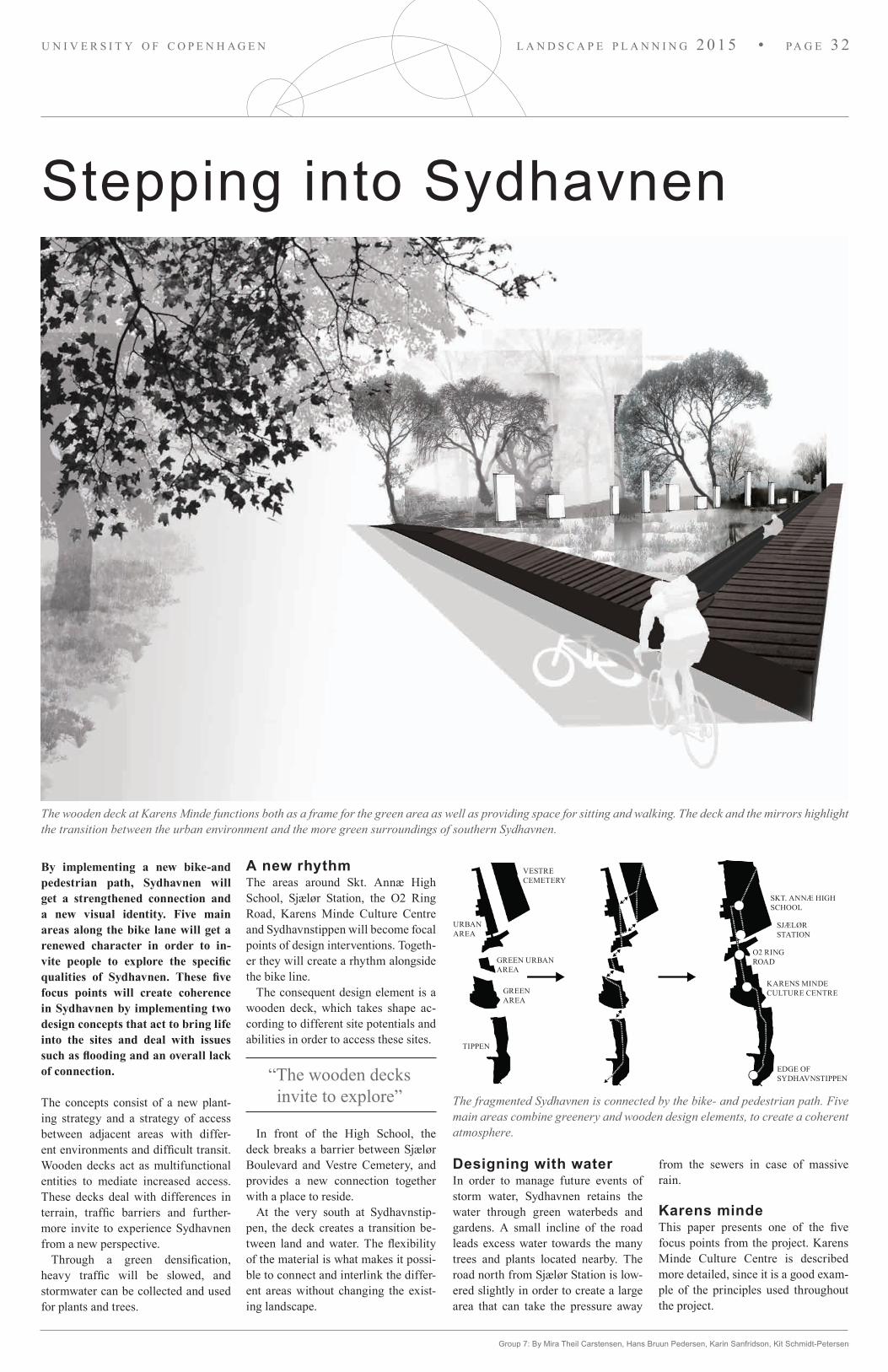
Stepping into Sydhavnen
The wooden deck at Karens Minde functions both as a frame for the green area as well as providing space for sitting and walking. The deck and the mirrors highlight the transition between the urban environment and the more green surroundings of southern Sydhavnen.
By implementing a new bike-and pedestrian path, Sydhavnen will get a strengthened connection and a new visual identity. Five main areas along the bike lane will get a renewed character in order to in-vite people to explore the specific qualities of Sydhavnen. These five focus points will create coherence in Sydhavnen by implementing two design concepts that act to bring life into the sites and deal with issues such as flooding and an overall lack of connection.
The concepts consist of a new plant-ing strategy and a strategy of access between adjacent areas with differ-ent environments and difficult transit. Wooden decks act as multifunctional entities to mediate increased access. These decks deal with differences in terrain, traffic barriers and further-more invite to experience Sydhavnen from a new perspective.
Through a green densification, heavy traffic will be slowed, and stormwater can be collected and used for plants and trees.
Group 7: By Mira Theil Carstensen, Hans Bruun Pedersen, Karin Sanfridson, Kit Schmidt-Petersen
A new rhythmThe areas around Skt. Annæ High School, Sjælør Station, the O2 Ring Road, Karens Minde Culture Centre and Sydhavnstippen will become focal points of design interventions. Togeth-er they will create a rhythm alongside the bike line.
The consequent design element is a wooden deck, which takes shape ac-cording to different site potentials and abilities in order to access these sites.
In front of the High School, the deck breaks a barrier between Sjælør Boulevard and Vestre Cemetery, and provides a new connection together with a place to reside.
At the very south at Sydhavnstip-pen, the deck creates a transition be-tween land and water. The flexibility of the material is what makes it possi-ble to connect and interlink the differ-ent areas without changing the exist-ing landscape.
“The wooden decks invite to explore” The fragmented Sydhavnen is connected by the bike- and pedestrian path. Five
main areas combine greenery and wooden design elements, to create a coherent atmosphere.
Designing with waterIn order to manage future events of storm water, Sydhavnen retains the water through green waterbeds and gardens. A small incline of the road leads excess water towards the many trees and plants located nearby. The road north from Sjælør Station is low-ered slightly in order to create a large area that can take the pressure away
from the sewers in case of massive rain.
Karens mindeThis paper presents one of the five focus points from the project. Karens Minde Culture Centre is described more detailed, since it is a good exam-ple of the principles used throughout the project.
VESTRE CEMETERY
URBAN AREA
GREEN URBAN AREA
TIPPEN
GREEN AREA
SKT. ANNÆ HIGH SCHOOL
SJÆLØR STATION
O2 RING ROAD
KARENS MINDECULTURE CENTRE
EDGE OFSYDHAVNSTIPPEN
l a n d s c a p e p l a n n i n g 2 0 1 5 • pa g e 3 2u n i v e r s i t y o f c o p e n h a g e n

Group 7: By Mira Theil Carstensen, Hans Bruun Pedersen, Karin Sanfridson, Kit Schmidt-Petersen
Section showing the transition into the Karens Minde area, which is emphasized by the wooden deck and the row of mirrors.
The triangular corner of Karens Minde is highlighted by the wooden deck, reaching down towards the lower areas potentially containing rain water.
Entering the greenKarens Minde Culture Centre is encir-cled by a green area in the middle of an urban context. A wooden deck runs along the edge of the northern corner, creating a smooth entrance to the area.
The deck frames a lower lying area, which serves as a site of water reten-tion that collects excess water in the area during heavy rains. The deck al-lows for access close to the water sur-face by two steps down towards the area creating an enclosed space facing Karens Minde.
The deck continues south in a large stretch of steps creating an interlink-ing transition between the urban and the green landscape. The deck reaches down towards the sidewalk in both ends for an easy access to the deck.
Back when the area was used for ag-riculture there was an extensive ditch for drainage stretching from Karens Minde down towards the channel. The story of this ditch is highlighted in Karens Minde by mirrors in different heights reflecting the contrast between the urban and the green landscape. The mirrors disguise the urban envi-ronment from inside Karens Minde and from the outside they highlight the transition between the urban and the green environment with the sub-stantial vegetation rising up above the mirrors.
A fragmented deck continues south-west of Karens Minde highlighting traces of the past with a new ditch alongside, which collects excess water from the area.
1:10 000
1:500
1:300
BIK
E PA
TH
HIS
TOR
ICA
L PA
TH
ENTRANCE
VESTRECEMETERY
SKT. ANNÆ HIGH SCHOOL
STATION DECK
ExISTING TREES
NEW TREES
WATER MANAGEMENT
WO
OD
EN D
ECK
BIKE PATH
BIKE PA
TH
ROA
DBIK
E PATH
PATH
PATH
ROAD
STREET LIGHTSSJÆLØR STATION
O2 RING ROAD
ILLUMINATED PATH
SYDHAVNSTIPPEN
BUNKER DECKRO
W O
F M
IRRO
RS
DECK POND KARENS MINDEBIKEPATH
ROAD
WOODEN DECK
RAINWATER MANAGEMENT
THINNING OF VEGETATION
KARENS MINDE CULTURE CENTRE
RAINWATER MANAGEMENT
BIK
E PA
TH
SCHOOL DECK:DECK
PEDESTRIAN AND BIKE TRAFFIC
CAR TRAFFIC AND PLANTINGS
KARENS MINDEDECK:DECK
PEDESTRIAN AND BIKE TRAFFIC
CAR TRAFFIC AND PLANTINGS
Plan of Sydhavnen including the concepts for three of the five focal points.
WATERFRONT DECK:DECK
PEDESTRIAN TRAFFIC
l a n d s c a p e p l a n n i n g 2 0 1 5 • pa g e 3 3u n i v e r s i t y o f c o p e n h a g e n

The northern corner of the cemetery towards the intersection of Vigerslev Allé and Sjælør Boulevard, a large open space emphasises on the beginning of the new bike path and creates a key entrance for the cemetery (1).
Sydhavnen is an area with several strong identities. The area, extend-ing from the northern top of Sjælør Boulevard to Tippen in south, con-sists of three different neighbour-hoods – each with a different char-acter and atmosphere. The new bike path, Zyd Way, will connect these three neighbourhoods and create a coherency in the area as well as en-hance the different existing quali-ties.
The three neighbourhoods of Syd-havnen are Vestre Kirkegård in the north, the urban area with Karens Minde in the middle and the pastoral landscape in south known as Tippen. Vestre Kirkegård represents a rigid structural composition with sym-metrical placed elements. The urban area and Karens Minde is character-ised by three story blocks with smaller intimate urban spaces in between and Karens Minde with several functions and activities such as a culture house, horses, petting zoo, a dancing hall etc. In this neighbourhood, the rigid com-
Group 8: By By Amra Vehabovic, Maria Skytt Burr, Sheila Kalsi, Gerard O’Connell
position gradually dissolves towards Karens Minde. At Tippen the rigid composition, created by the housing area and road structure disappears and the pastoral landscape with its curvy paths and clumps of trees extends to the meeting between land and sea.
The Greater PerspectiveCopenhagen has a number of existing green, two-way bike paths, which cre-ate easy access and connection for cy-clists between the different parts of the city. Zyd Way which runs from the top of Sjælør Boulevard to Tippen in the south will cross and link these existing bike paths and become an important part in the larger infrastructure.
ConceptThe main focus of the project is to con-nect the three neighbourhoods with a bike path through the area that corre-lates the different identities and char-acters of the neighbourhoods as well as it creates a coherent experience along the course of the path. The connec-tion is supported by the use of materi-
Green bike connections in Cph in relation to Zyd Way
Karens Minde Culture House (2)
Structural compositions of Sydhavnen
ZYD WAY
Vestre Kirkegård
Urban area and Karens Minde
Tippen
North entrance (1)
Tippen (3)
l a n d s c a p e p l a n n i n g 2 0 1 5 • pa g e 3 4u n i v e r s i t y o f c o p e n h a g e n

Tippen viewpoint framed by birch trees (3)
Group 8: By By Amra Vehabovic, Maria Skytt Burr, Sheila Kalsi, Gerard O’Connell
als that are present through the whole area. Black corten steel, concrete and red ironwood are used as construction materials for surfaces and furniture. Additionally, the bike path connects the recreational areas of Sydhavnen such as Vestre Kirkegård and Karens Minde. The edge of the recreational areas will be redefined and opened up towards the bike path to emphasise the green areas and their qualities to the surrounding residential areas.
Design In the Vestre Kirkegård neighbour-hood, a two-way bike path is placed along the new cemetery wall. The wall consists of long stretches of strictly cut beech hedges, which are broken up around three new key entrances and three secondary entrances. The key entrances are placed at the larger bike connections that link Sjælør Boulevard and the east side of Vestre Cemetery. At the entrances, the hedge is replaced by black corten steel, and pavement changes. At the corners of the ceme-tery towards the road, two larger open squares emphasise the beginning and end of the cemetery. The beginning of the urban area with Karens Minde is highlighted by an entrance through the existing bunkers with a black corten steel wall that leads cyclists into the urban area. South of the bunkers, the
two-way bike path is placed along the green space with the large, old trees in between the three story housing blocks. Here the pedestrians are able to cross the greening and walk under the canopies on concrete paths that cut through a rain garden, which is created in the existing small depression in the terrain in the middle of the greening. A new entrance for the culture house in Karens Minde has been created, which turns the building to face the bike path and open up to the surround-ing neighbourhood. Thomas Koppels Allé on the east side of Karens Minde has been redesigned to a shared open street plan to slow car traffic. Thomas Koppels Allé gains a stronger identity and leads the bike traffic easily to-wards Tippen.
At Tippen, the paved path ends and the existing gravel path takes over. Along the flowing paths of Tippen, small scale interventions have been placed in spots with great spatial qualities. These consists of a canoe pontoon to allow access to the water, small viewing shelters which build on the existing amenity of Tippen. The interventions are highlighted by clus-ters of planted birch trees. Their white stems and loose canopies will create a unique atmosphere around the in-terventions and guide users towards them.
New main entrance to Karens Minde Culture House (2)
Plan 1:10.000
N
Vestre Kirkegård
North entrance (1)
Bike path
Swale
Entrance by high school
South entrance
Roundabout
Bunker entrance
Storm water retention basin
Hedges/ secondary path
Open plan street scape
Paved path
Gravel path
Pontoon
Tippen view point (3)
Rain garden
Karens Minde Culture House (2)
Karens Minde
Tippen
l a n d s c a p e p l a n n i n g 2 0 1 5 • pa g e 3 5u n i v e r s i t y o f c o p e n h a g e n

The Green Line
Fig. 1. The Green Line creates a direct connection from Vigerslev Alle to Tippen handling storm water issues. When the straight line deviates the ditch becomes rain gardens for water retention. Volumes of canopies and a distinct brick paving create the atmosphere of the rain gardens. The use of the brick bear witness to a tradition of Sydhavnen being born in the period of industrialization.
The Green Line provides a strong connection in the project area Zyd- havn. It consists of a coherent pe-destrian and bike route and a ditch along the area, holding and lead-ing local storm water. The concept proposes a strengthened physical and visual connection from north to south interrupted by deviating spots for water retention and urban renewal. Hence, The Green Line contributes to a more sustainable Zydhavn.
The project site of Zydhavn stretches from Sjælør Boulevard to Tippen. Along this stretch the connection is in-terrupted by roads and railway tracks, creating transitional areas. These are-as have the potential of improving and enhancing connectivity through small scale urban interventions.
Group 9: Mette Blicher, Troels Sindballe, Janka Bulath & Isabella Friis
Sydhavnen also struggles with the consequences of climate change lead-ing to problems with storm water just as many other urban areas.
Sjælør Boulevard has a high im-portance of guiding traffic towards Karens Minde and Tippen, as well as the neighbouring areas of Valby and Sydhavn including other recrea-tional sites such as Valbyparken and Vestre Kirkegård. Though, the route appears fragmented and the different passages are not experienced unified which weakens the coherency. Sjælør Boulevard functions as the backbone of Zydhavn, but the structure and ac-cess needs to be improved. In order to restore the structure and exploit the potentials of the backbone a green line is defined.
Flow
Retention
Flow
Retention
Flow
Retention
Bridge to Søndermarken
Skt Annæ Rain Garden
Sjælør Rain Garden
Roundabout
Gate to Karens Minde
Karens Rain Garden
Rain Forest
Bridge to Tippen
Gate to the sea
Way to Søndermarken
Way to the city center
Planned entrance to the cemetery
Train stationWay to the city center
Karens Minde
Way to Tippen
Way to the city center
Valbyparken
Tippen
Connections Water Flow Concept
Access to Vestre Kirkegård Sjælør Boulevard
Skt. Annæ Gymnasium
A2A1Skt. Annæ Rain Garden Section Skt. Annæ Rain Garden 1:350
Transition
Transition
Transition to Karens Minde
Transition to the sea
l a n d s c a p e p l a n n i n g 2 0 1 5 • pa g e 3 6u n i v e r s i t y o f c o p e n h a g e n

The Green LineThe Green Line is a lush ditch accom-panied by a pedestrian and bicycle path that enhances the stretch from Sjælør Boulevard to Tippen. At specif-ic spots it creates new spaces with the intention of combining water retention with recreation, interaction and stay. Rain GardensThe terrain slopes down towards Sjælør Boulevard on both sides of the road. Therefore it is logical to continue leading the water south towards reten-tion areas along the way. The straight green line guides the water flow and when the line deviates the water is re-tained. The water retention areas with low-ered ground level are rain gardens that appear at the deviations of the Green Line. In dry periods the rain Gardens
1:11.000 plan: the concept of the Green Line
The Rain Forest
Bridge to Tippen
Karens Rain Garden
Sjælør Rain Garden
Skt. Annæ Rain Garden
New entrance and pathway
Bridge to Søndermarken
Vestre Kirkegård
A1A2
Skt. Annæ Gymnasium
Sjælør st.
Karens Minde
Mozarts Plads
Valbyparken
Tippen
Roundabout
Storm water retention areas
New plantings
Rainwater ditch and pathways
Pavement that connects to the other side of the boulevard
provides spaces for recreation. The Rain Gardens are easily recognazable by the high volume of plantations and by the distinct brick paving expansion to their surroundings.
TransitionsTo solve the fragmentation of the con-nection throughout the site The Green Line includes a new bridge to Søn-dermarken and an improved bridge to Tippen.
The transitions between different parts of Zydhavn are enhanced by gates that lead the movement further on. The gates are inspired by the cor-ten steel gates in Vestre Kirkegård.
The Green Line embraces the water throughout Zydhavnen shaping vari-ous spaces on its way and ends at the transition to the sea.
Visualization 3; Tippen. The cleared path follows the edge of the Green Line out to the ocean. The transition to the coastline is marked with a gate.
Visualization 2. The storm water ditch. A view along the path of the ditch go-ing towards the roundabout and the opening to Karens Minde. The gate in the horizon provides a clear transition to the green surroundings of Karens Minde.
A2
Lowered pathway
B1B2
Gate
Section Tippen 1:350
Group 9: Mette Blicher, Troels Sindballe, Janka Bulath & Isabella Friis
B1
B2
l a n d s c a p e p l a n n i n g 2 0 1 5 • pa g e 3 7u n i v e r s i t y o f c o p e n h a g e n

The Zydhavn Way
Visualisation of Karens Minde Square: Showing the concrete slabs at the sqaure and the green islands with vegetation and trees. High grass will work as a frame of the square where public events, markets, theatre etc. can get people together in the heart of Sydhavnen.
Four Areas: Throughout analysis of the urban spaces and structures, four differ-ent areas with strong characters is selected to emphasise and embrace.
The overall concept seeks to add new dimensions to the existing surroundings by place based interventions. The aim is to strengthen the existing forms and creating recognisability and accessibility across the area. This is done by defining the existing forms and establishing new interventions as a contrary to the current conditions. Rigid ordered areas are infiltrated by flowing organic forms, while more natural areas see straight aligned alterations. Each place refers to one another, guiding people through the entire area.
Four AreasTo overcome the issues of connectivity and the lack of public life in Sydhavnen, more public spaces designed for people to occupy and enjoy throughout the day or night are needed. In order to accomplish this, four specific sites have been pointed out as significant places each having different experiences and architectural languages. The first two areas are along Sjælør Boulevard with strict built forms and vegetation.
Group 10: By J. Skajaa, M. VandenDungen, M. Krebs, M. Fallah, N. Rasmussen
The third is Karens Minde and its romantic landscape with organic forms and suburban atmosphere. Tippen is the fourth site with the fairly open landscape and haphazard placed vegetation. Every chosen place is getting a physical structure, a volume, and a connected bicycle route. Using the volume of trees and the surfaces to emphasise the current built structures and forms, a new physical layer will be added to tie the surrounding built forms and existing vegetation together. This way we aim to create coherent places in human scale, whilst the identifiable forms and structures will guide people through the entire project.
Stormwater ManagementThe topography of Sydhavnen makes stormwater from a large area run towards the harbour area in the south. The water ends up in people’s basements causing significant damages to property. Therefore, our aim is to develop a comprehensive plan for the cloudbursts in Sydhavnen, which treats the rain water locally, without changing its natural direction
southwards. The plan ensures synergy between the rain water and the development of green recreational qualities. It provides coherence between the public areas, greenery, squares and roads. The goal is to create a green vein extending from Sjælør Boulevard to Karens Minde in order to reduce the risk of flooding.
AccessibilityThe design establishes specific connections to its surroundings allowing for greater movement of people across and through the areas. Each place flows more coherently and seamlessly into the next, providing easy entrances throughout the project.
Existing structures Stormwater Bicycle Route Intervention areas
l a n d s c a p e p l a n n i n g 2 0 1 5 • pa g e 3 8u n i v e r s i t y o f c o p e n h a g e n

Concept master plan approx. 1:10000: Establishing a north-south connection through redesigned nodes and a bikelane.
Group 10: By J. Skajaa, M. VandenDungen, M. Krebs, M. Fallah, N. Rasmussen
2 // Mozarts Kile In this area we want to enhance the existing slight organic shape of the terrain to better counter the strict structures created by the building edges and the trees. The idea is to make the surface ground deeper emphasising its swirling form. The swale is designed to deal with rain water. Platforms of concrete walk-overs ensure easy access across. By clearing bushes in-between the bunkers the entrance is more welcoming, but still reduces noise.
Section: Karens Minde Park: Showing the water detention area, the bike lane leading people through the area and the new public square.
Detail Plan 1:2000 Karens Minde Park: In the west appears water management with a wood deck, the newly built bike path and in the middle the square.
1 // Sjælør Boulevard The idea of this area is to break up the strict built structure with intersecting organic shaped surfaces and trees. The road profile is changed to create more sidewalk space to reduce the large scale feeling. Bike traffic is united in a two-way bike lane on the churchyard side, ensuring undisturbed public life on the functional side. The road has four strategically placed “spots” in relation to functions, connections and churchyard entrances. The edge to Vestre Kirkegård is defined by a brick wall.
3 // Karens Minde ParkThe public space square in Karens Minde Park is a place where people can interact socially in a pleasant nature like environment. The square is the main object, which is designed and oriented to unify the surrounding buildings, while playing with the flowing organic forms in the area. Additionally, the park allows visitors to interact with water, which is an active part of the design. The aim with the design in this area is to make Karens Minde Park a place where visitors can interact with nature.
4 // BioBæltet Bio-Bæltet has been designed to make visitors contemplate the relationship between natural landscape and artificial intervetions. The idea is to make a system of rules and a direction, in a place where no such thing exist. Islands of trees, placed in a tight grid form, to tell the history of the man-made area as an old dump. The gravel path system is designed to lead the visitor around the area, without compromising the desire one might have of exploring the area on their own.
1
2
3
4
Cafe corner
High grass
Concrete slabs
Urban gardens
Horse paddock
Bike path
Wood deck
Park
Detention area
Detention area
Wagners vejSjæ
lør B
oule
vard
Thomas koppel A
llé
NN
Connection to CPH.Concept diagrams
Brick Wall
NW Entrance
W Entrance
SW Entrance
Sankt Annæ Square
Bike Lane
Station
Bunker
Ditch
Bike Lane
Water detention
Karens Minde
Square
Swamp
Bike Lane
Wood Deck
Island of Trees
Existing Trees
Sydhavn Beach 2016
Valby Parken
Tippen
Vestre Kirkegård
Forest
l a n d s c a p e p l a n n i n g 2 0 1 5 • pa g e 3 9u n i v e r s i t y o f c o p e n h a g e n

Do you want to de s ign the c i t i e s o f tomor row?
d e pa rt m e n t o f g e o s c i e n c e s a n d n at u r a l re s o u rc e m a n ag e m e n tu n i ve r s i t y o f co pe n h ag e n
www.studies.ku.dk