landschaft, pueblo and altepetl: a consideration of ... · very often, the landscape paintings made...
TRANSCRIPT

Full Terms & Conditions of access and use can be found athttp://www.tandfonline.com/action/journalInformation?journalCode=rjcg20
Download by: [University of Veracruzana] Date: 22 October 2015, At: 07:25
Journal of Cultural Geography
ISSN: 0887-3631 (Print) 1940-6320 (Online) Journal homepage: http://www.tandfonline.com/loi/rjcg20
Landschaft, pueblo and altepetl: a consideration oflandscape in sixteenth-century Central Mexico
Federico Fernández-Christlieb
To cite this article: Federico Fernández-Christlieb (2015) Landschaft, pueblo and altepetl: aconsideration of landscape in sixteenth-century Central Mexico, Journal of Cultural Geography,32:3, 331-361, DOI: 10.1080/08873631.2015.1041307
To link to this article: http://dx.doi.org/10.1080/08873631.2015.1041307
Published online: 29 Jun 2015.
Submit your article to this journal
Article views: 71
View related articles
View Crossmark data

Landschaft, pueblo and altepetl: a consideration of landscapein sixteenth-century Central Mexico
Federico Fernández-Christlieb*
Institute of Geography, National Autonomous University of Mexico, Mexico D.F.,Mexico
In 1521, the Spanish conquistadors defeated the Nahuas of CentralMexico. Spain was ruled at the time by the House of Habsburg, and itsadministrators became familiar with the German concept of Landschaft.By 1570, they used this concept to prepare and launch a survey of theindigenous communities which called themselves—and their lands—altepetl. The purpose of this paper is to show to what extent the termsLandschaft and altepetl are equivalent since modern scholars havedescribed both as organized “communities” subject to a customary“law” and possessing a specific piece of “land”. The main obstacle forthis comparison is that in the sixteenth century the Spaniards did not havea word equivalent to landscape, and they used words like pueblo, pagoand pintura instead, depending on the context. This paper describes thegeneral characteristics of the altepetl in Central Mexico and focuses on itsrepresentation by analysing some maps made after the conquest in thearea of Cholula, current State of Puebla. The comparison of Landschaft,pueblo and altepetl in historical context is pertinent for culturalgeographers since it was during the sixteenth century that the conceptof landscape, as we know it today, was taking shape.
Keywords: landscape; Landschaft; Mexico; paisaje; altepetl; Cholula
Introduction
When the conquistadors arrived in Central Mexico in 1519, the concept ofLandschaft (German for landscape) was already in use in Germanic languagesin Europe (Olwig 2002). That same year Charles I, the Flemish king ofCastile, was elected as the Holy Roman Emperor, and thus Spain became apart of a predominantly Germanic empire (Kamen 2003; Carrasco 2005;Espinosa 2009). In the years that followed, through the process of conquest ofthe Aztec Empire, the Spaniards learned that the landscapes they encounteredwere called altepetl and they translated this term as pueblo (town, people)since they did not yet have in Castilian a synonym of Landschaft.1 As a
*Federico Fernández-Christlieb is a Professor of Geography in the Instituto deGeografia at the Universidad Nacional Autónoma de México (UNAM), Circuitoexterior Ciudad Universitaria, México D.F. 04510, Mexico. Email: [email protected]
Journal of Cultural Geography, 2015
Vol. 32, No. 3, 331–361, http://dx.doi.org/10.1080/08873631.2015.1041307
© 2015 JCG Press, Oklahoma State University
Dow
nloa
ded
by [
Uni
vers
ity o
f V
erac
ruza
na]
at 0
7:25
22
Oct
ober
201
5

cultural geographer of Mexico, I am interested in the origin of the conceptpaisaje (Spanish for landscape) and the uses this term had in Central Mexicoas early as I can excavate in the sources. The Spanish language wasintroduced to Mexico in the sixteenth century at the same time that theconcept “landscape” was taking shape in Europe, both in Germanic and inRomance languages. The equivalent terms for landscape like Landschaft (inGerman) and paysage (in French) were coined in the sixteenth centurywhereas the Spanish term paisaje appeared only in the eighteenth century(Corominas 1983).
If Spaniards did not use the word paisaje, what kind of concepts were theyusing in Mesoamerica at the historical moment when they were dramaticallytransforming the landscape? Furthermore, if the Nahua people of CentralMexico had equivalent concepts to denote landscape, what did they call theircommunities, territories and environment, and how did they represent them?I used a combination of three approaches to address these questions.
First, I examined the definition of landscape in Germanic and Romancelanguages in the sixteenth century. Then I compared the definition ofLandschaft given by the geographer Kenneth Olwig (1996, 2002) with theindigenous term altepetl, studied by several scholars who have specialized inCentral Mexico. The purpose of this comparison was to examine the extent towhich the German concept is equivalent to the Nahua concept in the sixteenthcentury given that an altepetl has also been described as an organizedcommunity whose members were tied to the land by a customary law and whohave an interaction with the environment (Licate 1980; Gibson 1983). Thecomparison focuses on the moment of the conquest and the decades after it forwhich information is available. This paper presents for the first time acomparison between the sixteenth-century German and Nahua concepts.
The third approach involved analysing some representations of specificaltepetl. A graphic representation is fundamental to complete the notion oflandscape because such representations help to reflect and retain memories ofthe community, manifest power and hierarchy, and provide information aboutsome of the land-use rules and habits (Duncan 1990; Gruffund 2003;O’Connor and Kroefges 2008). This is part of the aesthetic aspect of theconcept (Berque 2000; Cosgrove 2002; Donadieu 2006).
These approaches necessitate that I study colonial Nahua maps, firstbecause pre-Hispanic maps are extremely rare (many were destroyed by theEuropeans), and second because colonial ones show the process of hybrid-ization that was also taking place on the lands of New Spain. I selected thecase of Cholula, so the final part of this article will be devoted to the study ofseveral representations of that altepetl and some of its immediate neighbours.The selection of Cholula, in the Atoyac River valley (Figure 1), is justifiedbecause it has been continuously inhabited for the last 3000 years (Carrascoand Sessions 2010), and the evolution of the term altepetl is inherent to thisplace; that is to say Cholula is one of the sites where the concept altepetlmay have been invented (McCafferty 2008). In order to better understand the
332 F. Fernández-Christlieb
Dow
nloa
ded
by [
Uni
vers
ity o
f V
erac
ruza
na]
at 0
7:25
22
Oct
ober
201
5

Figure 1. Map of the Basin of Atoyac River and main places named in the article. Map by Luis Fernando Gopar Merino, 2013.
Journalof
Cultural
Geography
333
Dow
nloa
ded
by [
Uni
vers
ity o
f V
erac
ruza
na]
at 0
7:25
22
Oct
ober
201
5

altepetl of Cholula, I made several site visits so that I could comparethe features of the landscape represented in the ancient maps with thelandscape today. These site visits also allowed me to interact with localresidents which provides great insight into the landscape being studied, as mycolleagues and I have found in other places in Central Mexico (Fernández-Christlieb et al. 2006; Chávez-Peón-Herrero et al. 2010).2 Scholars whopreviously did fieldwork in the area (Bonfil-Batalla 1988; Reyes-García 2000;Kobayashi 2012) observed that Nahua culture is still strong in Cholula’swards, neighbouring towns and traditional institutions; consequently, some ofthe traditional organization of space is still visible today. Nevertheless, it isimportant to evaluate the information carefully and not assume that theinhabitants today behave like the inhabitants 500 years ago (Knab-H 2012).
The German concept of Landschaft was certainly less clear for theSpanish-speaking first conquistadors than for the King himself. From themoment the Habsburgs acquired complete control of the Empire in 1521(Lovet 1986; Carrasco 2005; Espinosa 2009), decision-makers—in Spain aswell as in the Americas—had to understand the kind of information that theHabsburgs required in order to imagine the Landschaften of New Spain.Landschaft was a concept that would facilitate the description of lands and theunderstanding of indigenous communities; it would be useful for planning thecolonial administration. For that purpose, the Spanish administrators based inMadrid launched surveys and obtained descriptions and representations of theindigenous as well as Spanish settlements in Central Mexico though the taskwas huge and they never completed it. This article argues that Landschaft andaltepetl could be considered as synonyms although there was no direct contactbetween the German and the Nahua languages except perhaps for the group ofGerman colonists that negotiated an agreement with the Spanish Crown before1546 to cultivate woad (Isatis tinctoria) some 200 km east of the area we arestudying (García-Martínez 2005).
Pueblo, Pago and Pintura: terms integrated in “Landschaft”Anglophone cultural geographers have amply studied the concepts oflandscape and Landschaft (Relph 1981; Cosgrove 1984; Duncan 1990; Tilley1994; Haber 1995; Mitchell 2007; Jackson 2008; Sauer 2008) while Frenchgeographers have explained paysage quite sufficiently (Avocat 1982; Berque1984; Berque 1990; Roger 1997; Claval 2003, 2012). Nevertheless, culturalgeographers have given less attention to the equivalent terms in Spanish.3 Theoriginal term Landschaft that is crucial to this discussion has beenreconstructed by Kenneth Olwig who started by contesting the general ideathat landscape was a notion used to refer to a “restricted territory” or the“appearance of a land as we perceive it” (Olwig 1996, pp. 630–631).Furthermore, his latest book dismantles the broadly accepted assertion that theconcept of landscape and the words for it in both Romance and Germaniclanguages emerged around the turn of the sixteenth century to denote
334 F. Fernández-Christlieb
Dow
nloa
ded
by [
Uni
vers
ity o
f V
erac
ruza
na]
at 0
7:25
22
Oct
ober
201
5

“a painting whose primary subject matter was natural scenery” (Olwig 2002,pp. xxiv–xxv). Olwig states rather that the concept of Landschaft was used inEurope before the sixteenth century to refer to a political community whosemembers were united by legal bonds. So the elements “community”, “law”and “land” (land in its two meanings as “territory” and as “environment”) arepresent in the original German definition of landscape. In this section,I identify the terms that Spaniards used to refer to the same elements found byOlwig within the word Landschaft. These terms are: pueblo (people), pago(country) and pintura (painting). As a brief introduction, pueblo was asynonym of “community”, pago a synonym of “land” and pintura was therepresentation of the land as well as a legal instrument to claim it.
Before being reduced to a scene in a painting, landscape was a richconcept vital to the social organization of Germanic Europe. Landschap inFlemish and Dutch, landskab in Danish, landskap in Swedish and Landschaftin German were concepts designating a community organized politically overthe base of customary law (Olwig 2002). As a consequence of living togetherfor generations in the same place, the place itself would be assimilated legallyby the members of the community, and even the boundaries of the place couldbe fixed by them and recognized by others as a territory. Thus, community,law and land were part of the original definition of Landschaft; later the landcould be represented in a canvas also named Landschaft. Retaining only thislast part of the definition—painting as Landschaft—misses the richness of ahistorical concept that has long been central to geography.
Very often, the landscape paintings made by Flemish and Dutch paintersconsist of representations of the habits of the people living in a place, theireconomic activities and the organization of labour and social life. In thesepaintings, it is possible to identify farming lands and urban areas, preservedwoods and clearings, roads and castles, and the boundary of communalterritory. The observer of the painting could also read in it some of the rulesthat tied the community together. Olwig says that Landschaft was conceivedas a combination of community, justice, nature and environmental equity(Olwig 1996). He illustrates his analysis with Pieter Brueghel’s 1565 paintingcalled Haymaking (Olwig 2002). There are mostly cultural features of theplace painted although it is also possible to distinguish also natural elementslike the shape of the hills on the horizon and the location of the river. Thisinteraction of people and nature captures the etymology of the word composedby the elements Land (land, soil, country, environment) and shaffen (to create,to transform) (Haber 1995; Jackson 2008).
The evolution of the idea of Landschaft from medieval times up to theRenaissance coincides with the Reconquista, that is the struggle of theSpanish kingdoms to expel the Arab and Berber Muslims from the IberianPeninsula. The historian Henri Kamen (2003) has explained how the successof the last stage of the Reconquista was assured by the support of theChristian countries that saw that war in terms of a European crusade. Funds,soldiers and war techniques arrived from different corners of Europe,
Journal of Cultural Geography 335
Dow
nloa
ded
by [
Uni
vers
ity o
f V
erac
ruza
na]
at 0
7:25
22
Oct
ober
201
5
including the decisive help of Flemish artillery. After the unification of Spainin 1469 and the expulsion of Muslims in 1492, Charles of Habsburg becameking of Spain in 1516. Born and educated in Flanders, Charles I learnedSpanish later and united an important number of realms including parts ofcurrent Germany, Austria, Hungary, Italy, Belgium and the Netherlands. Aspreviously noted, he became the Holy Roman Emperor Charles V. He broughthis own bankers from the Netherlands to Spain as well as the knowledge toadminister the kingdom more efficiently.4 According to Kamen, “everything… demonstrates the prior position occupied by the Netherlands in the mindsof the early Habsburg rulers of Spain” (Kamen 2003, p. 78).
Graphic techniques useful to administer the lands of the kingdom, likecartography and painting, were well developed in Flanders (Links 1972; Kagan2000). Some works were launched under the reign of Charles V to produce abetter cartography of Spain, like the Atlas de El Escorial in 1539 or theMapa deEsquivel in 1555 (Crespo-Sanz 2005, 2009). In addition, Philip II, son of CharlesV, fostered the activity of Landschaft painters within the Iberian Peninsula inorder to create a graphic record of the territories controlled by his crown (Brown1972; Kagan 2008). Another term used for this type of painting was “vistas”(views). The Flemish landscape painter Anton van den Wingaerde arrived at theSpanish court commissioned to describe the cities of the realm on the IberianPeninsula. He toured Spain for some years from 1561 and drew a collection ofmore than 60 vistas of the most important towns and cities (Haverkamp-Begemann 1969; Galera-i-Monegal 1998). In these Landschaft drawings, it ispossible to discern some of the activities of the people and their imprints on theland. The Spanish term, la ciudad (the city), referred to both the members of thecommunity and their activities. Ciudad was defined before the Renaissance as a“group of persons united by social bonds”. This is the definition provided by themost important source of Spanish laws for medieval time: Las siete partidas byIsidoro de Sevilla. This author explains that the city or civitas is formed by the“citizens [cives], that is the inhabitants of the urban [urbs]. The urban refers tothe material fabric of the city while the civitas refers, not to its stones, but to itspeople” (Sevilla 1994, p. 227).5 This definition is also applicable to smallersettlements called pueblos (towns). The etymology of pueblo derives from Latinpopulus meaning the ensemble of citizens (Corominas 1983). Pueblo was theword used in the sixteenth century to denote the gathering of all men incommunity (Alfonso-X 1974). Like the concept ciudad, pueblo also signified theensemble of streets, churches, squares, houses and all the material elements ofthe town.6 So these medieval conceptions of ciudad and pueblo may underlie thefuture notion of landscape in the sense that “community” and “land” make uppart of the same entity.
Wingaerdes’ drawings were not the only initiative conducted by KingPhilip II to record the geography of territories and peoples controlled by theSpanish Crown. The decade of 1570 was intense for cosmographers,cartographers and chroniclers working on the production of data to give amore accurate idea of the realm that at the time covered important parts of the
336 F. Fernández-Christlieb
Dow
nloa
ded
by [
Uni
vers
ity o
f V
erac
ruza
na]
at 0
7:25
22
Oct
ober
201
5

Americas, including the Antilles. For the purpose of this article, I focus onthe surveys, known as relaciones that were organized in Spain as well as inthe Americas. Juan López de Velasco, the chronicler-cosmographer of thecourt of Philip II, launched one survey in Spain and another in Central Mexicoalmost simultaneously (Portuondo 2009). The first is known as RelacionesTopográficas de Felipe II (Blázquez-Garbajosa 1983; García-Guerra andVicioso-Rodríguez 1993), and the second is known as Relaciones Geográficasdel siglo XVI (Cline 1972; Mundy 1996). Both consisted of some50 questions—about history, demography, laws, economic activities andphysical geography. In Central Mexico, the survey had to be answered by theSpanish councils or priests with information provided by local elders (Acuña1986, p. 13 and 17). These surveys are good examples of the Habsburgintention to obtain high-quality reports in order to better control the newterritories.
By reading the responses to the Relaciones Geográficas (RG) of CentralMexico, one can gain a very good idea of the Landschaften of the placescalled pueblos and their surroundings. For example, questions 1, 2, 9, 13 and14 are about the history of the community (meaning of the place name,founder of the town, ancient ceremonies, ancient rulers, old habits); questions5, 13, 17, 23, 26, 31, 32 and 37 are about the structure and function of thecommunity (population, language, illness, remedies, buildings, agriculture,etc.). Questions 7, 8, 11, 15, 33 and 34–36 are about the customary laws (localand Spanish authorities, religious authorities, hierarchy of towns, governance,taxes, territorial borders and regional enemies). Finally, the theme of the landis also subject to the inquiry: questions 4, 6, 8, 26, 27, 29 and 30 ask about theterritory (extension and limits, altitude, positions of the sun, animals, plants,mines, quarries, salt mines, woods, waters, soil, etc.), and questions 3, 4,19–22 and 49 ask about the environment (water springs, rivers, lakes,volcanoes, hills, caves, forests, skies) (Acuña 1986).
As noted previously, in Spanish, pueblo means “people” as well as “town”(Real Academia Española 1992). There was another word in Spanish used todenote a community, a place of human habitation and environmentalinteraction: pago. Isidoro de Sevilla (1994) defined it as a group andconcentration of many people in a single place, and other sources of theearly seventeenth century stated that pago implied for its settlers theobligation to pay (pagar) rent to the landlords (Covarrubias-Orozco 1979).In New Spain, often the word pago referred to a specific piece of land withinthe territory of a pueblo (Martínez 1984; AGN 1617). In all Romancelanguages, pago (or pagus in Latin) is the origin of the modern word for“country”: país in Spanish, paese in Italian, pays in French and pais inPortuguese. País was sometimes used in New Spain to describe the relief atthe local scale and the characteristics of the landforms (Acosta 2003). Thesame root was used to coin paisaje (landscape) in Spanish but that onlyhappened in the early eighteenth century (Corominas 1983). In other Romancelanguages, landscape does have earlier equivalents: paesaggio in Italian,
Journal of Cultural Geography 337
Dow
nloa
ded
by [
Uni
vers
ity o
f V
erac
ruza
na]
at 0
7:25
22
Oct
ober
201
5

paysage in French and paisagem in Portuguese (Avocat 1982; Cosgrove 1984;Roger 1997; Cortelazzo and Zolli 1999).
By the time the Spaniards were fighting the Muslims to expel them fromEurope, pago had come to mean the space where one was born or where aperson is rooted, and by extension place, town and region. That is exactly themeaning that pago still has in some parts of Argentina, Uruguay and Peru(Real Academia Española 1992). Pago was also used to mean an “agriculturaldistrict” and a small “town or village” as opposed to a “city” (Corominas1983; Ramírez-Ruiz 2006). During the Reconquista, pago had rural connota-tions and its inhabitants were known as paganos (pagans) (Alonso 1986). Asthe Spanish troops advanced across the Iberian Peninsula, the process ofChristianisation was relatively fast in cities, but in smaller towns and in thecountryside the people put up greater resistance and often remained outsidethe wave of acculturation. For this reason, living in the countryside, that isbeing a peasant, became synonymous with being a pagan. The same word wasused for both notions in Spanish (pagano), French (païan), Portuguese(pagão), Italian (pagano) and Catalan (payén), and they became differentconcepts only later (Corominas and Pascual 1981).
The Flemish administration of Spain took advantage of the process ofChristianisation in Mesoamerica to ask for better information about the placesdiscovered. The authorities of New Spain were instructed to make representa-tions on paper of all the pagos or pueblos found in New Spain. Thechronicler-cosmographer López de Velasco asked the authorities of CentralMexico for a painting to illustrate the answers of the RG questionnaire.Question number 10 explicitly requests a pintura (Acuña 1986). The termpintura comes from “pictura or fictura (fiction), an image that represents thefigure of something and which once seen leads the mind to remember it”(Ramírez-Ruiz 2006, p. 206). Covarrubias in his dictionary published in 1611defines pintar (to paint) as “imitating natural or artificial things in severalcolours on a flat surface” (Covarrubias-Orozco 1979, p. 589). The 1737dictionary still defines país as: “the painting in which villas, places, fortresses,country houses and fields are painted” (Real Academia de la Historia 1737,vol. 5, p. 81). In this definition, painting and country are synonyms. It is likelythat, under the influence of the Dutch and Flemish Landschaft painters whotook on the task of representing pueblos, the understanding of pintura andpago came to include urban elements.
As we see, in the sixteenth century, the German Landschaft wasfunctionally equivalent to the Spanish words pueblo-pago-pintura combined,but on the other hand Augustin Berque maintains that whatever the languageis, if there is no word to express landscape, then the landscape does not exist(Berque 2000). Arguably, since Castilian speakers could express the conceptwith three established terms, a single equivalent to Landshaft was not entirelynecessary and was slower to evolve. In any case, the elements defining theGerman notion of landscape by the end of the sixteenth century were:(1) community, (2) law and (3) land. In the next part of this article, I will
338 F. Fernández-Christlieb
Dow
nloa
ded
by [
Uni
vers
ity o
f V
erac
ruza
na]
at 0
7:25
22
Oct
ober
201
5
compare these elements with the concept altepetl used by the indigenouspeoples of Central Mexico.
Altepetl as Landschaft
When the Spaniards arrived in Nahua lands, they were informed by theirtranslators that the societies they interacted with were called altepetl. InNahuatl, the main language spoken in Central Mexico, the word altepetlreferred to a highly organised and corporate community established in aterritory (Licate 1980; Lockhart 1992; Noguez 2001; García-Martínez 2005;Florescano 2009). As indicated, the Spaniards translated altepetl as “pueblo”(town or people) because it denoted both the buildings and the population;primary sources provide us with some other translations for altepetl: “housesof water”, “mountain of water” (Sahagún 1999) and “king” (Molina 2001).Historians have translated altepetl also as “ethnic state” (Lockhart 1992),“city-state” (Hicks 2012), “community” and “polity, kingdom, province”(Marcus 2000). The roots of the word are: atl (water) and tepetl (mountain)(Bernal-García and García-Zambrano 2006). I would argue that, from theperspective of cultural geography, the Spanish concept that best encompassesthe full meaning of altepetl is paisaje.
Describing the full territorial and environmental complexity of the altepetlin pre-Hispanic times is beyond the scope of this paper. Instead, I point out thegeneral features of the landscape of an altepetl after the conquest insofar as itis possible to contrast them with the three mentioned elements that make partof the definition of Landschaft: community, law and land.
Altepetl as community
The bonds between the members of the altepetl were not evident to theSpaniards since the groups of houses where the people lived were oftenscattered over the land and sometimes interspersed with other altepetl’sgroups of houses (Lockhart 1992). We know that every altepetl was a well-organized community ruled by a chief known as tlatoani and composed ofwards, calpolli (Gibson 1983; García-Martínez 2001; Florescano 2009). Thefamilies within a calpolli had the same ethnic origin, a patron god whoprotected them, and its members were specialized in a particular activityuseful for the whole altepetl. The population of the altepetl was divided intwo different social groups: the pipiltin (nobles) and the macehualtin(common persons) (Lockhart 1992; Hicks 2012). All of the altepetl had pre-Hispanic histories of alliances and confrontations. Many of them were part oflarger communities known as hueyaltepetl (great altepetl or confederation),and within these alliances specific calpolli established links with a calpolli ofthe other altepetl through marriage (Licate 1981). The ruler of the hueyaltepetlwas called hueytlatoani (great tlatoani) (Lockhart 1992). Spaniards putthemselves on the top of the hierarchy, but they respected the indigenous
Journal of Cultural Geography 339
Dow
nloa
ded
by [
Uni
vers
ity o
f V
erac
ruza
na]
at 0
7:25
22
Oct
ober
201
5

social and territorial organization because that was the way in which theycould control the local population, taxing and evangelizing them. TheSpaniards made an alliance with the noble social group as far as that wasconvenient. The altepetl or the hueyaltepetl was then called pueblo (town) andsometimes ciudad (city, when the Spanish authorities considered that it hadthe merits). The hueytlatoani was called cacique or señor (lord), and the wordcalpolli was translated as barrio (ward) (Marcus 2000).
Altepetl as law
Before the conquest, the relationships between all members of the altepetl andhueyaltepetl were regulated by customary law (Noguez 2001). Every altepetlhad clear community commitments like paying tribute, organizing festivitiesand providing a labour force such as peasants or builders. In order toaccomplish these collective tasks, there was a rotation system in which onealtepetl organized a celebration one year, for example, and another altepetlorganized it the next year, and the third year the celebration was organized byanother one and so on: until all altepetl had taken their turn and the cyclestarted again (Lockhart 1992). Following the rotation system, every altepetlalso had the right to provide the ruler for the confederation, so the centre ofthe hueyaltepetl used to move physically from one place to another dependingon which altepetl the current hueytlatoani came from (García-Martínez 2005).Rotation is the best example of how customary law was essential to thealtepetl.
When the Spaniards arrived, they identified the place where the ruler wasat that time as the number one place of the territorial hierarchy; therefore, theynamed that altepetl “cabecera” (head-town) and the rest of the altepetlforming the hueyaltepetl “sujetos” (subject-towns) (Gerhard 1977; Gibson1983). They did not fully understand the rotation system and ignored it forgovernment purposes and generally only kept it for religious and socialfestivities. From that time on, land possession was carefully regulated by theSpanish authorities. It is important to note that even if the Spaniardsmisunderstood the legal richness of the concept altepetl, they used this Nahuainstitution as the basis of new land regulations, particularly with respect topueblo boundaries. As a result of this, many municipalities today still have thesame limits as the original altepetl.
Altepetl as land
By the beginning of the sixteenth century, there were more than 300 altepetlin Central Mexico (García-Martínez 2001). Most of the altepetl weremythically or historically linked to a particular environment defined by thepresence of hills and water sources (López-Austin 1989; Albores and Broda1997; López-Austin 1999; López-Austin and López-Luján 2009). CentralMexico is a region in which three great mountain ranges converge and where
340 F. Fernández-Christlieb
Dow
nloa
ded
by [
Uni
vers
ity o
f V
erac
ruza
na]
at 0
7:25
22
Oct
ober
201
5

there are summits over 5000 metres above sea level. There are also largeplateaus and valleys with gentle slopes at high altitudes and an abundance ofwater which rises in small springs and forms streams which flow into shallowlakes. Hunting, gathering and lake fishing were good sources of food. Withintheir lands or not far from them, indigenous communities had easy access to abroad variety of fauna and flora.
In pre-Hispanic times, the land of the altepetl was called altepetlalli, andits pictorial record was preserved by the authorities of the altepetl orhueyaltepetl. The land of every calpolli was called calpollalli, and itscartographic records, including the names of the possessors, were kept bythe calpoleque (office-holders of the calpolli) (Lockhart 1992). Every altepetlhad three public buildings in its territory: a tecpan (palace), a teocalli (temple,pyramid) and a tianquiztli (market) (Lockhart 1992; Noguez 2001). Thepopulation used to live in small groups of two or three family housesdistributed around a patio where they had access to its little agricultural field(Escalante 2004). Ownership of the land was corporate but every altepetl hadland enough to cultivate, obtain wood, hunt and gather.
The connection the Nahua communities felt to their land is articulated inmyth. Each community had its own explanation of their creation andestablishment, and they all share an account of an arduous migration andsearch for the lands they now occupy. These myths place emphasis on thecommon physical features of the landscape of origin (e.g., Aztlan,Chicomoztoc) and the landscape they settled in (e.g. basin of Mexico,Cholula). Ritually, the newcomers would walk around the land to possess it(García-Zambrano 2006). That walking tour imitated the movements of thesun through the day and through the year, and in some cases that motiondetermined the order in which the altepetl and calpolli’s commitments andrights rotated. This ritual reconnaissance of the territory was often repeatedannually, in some cases up to the present day, to mark certain festivities andreaffirm the community boundaries.
The altepetl’s space was not divided into rural and urban. The conceptsurban and rural were clearly imported from Europe. Spanish chroniclers saidthat Nahuas lived scattered “like beasts on the fields” (Solórzano y Pereyra1930), so they promoted their civilization by concentrating them in new towns(Ramírez-Ruiz and Fernández-Christlieb 2006).7 This urban development wasalso a consequence of the mortality rate caused by the epidemics in CentralMexico (Gerhard 1977; Torre-Villar 1995). The process of gathering thesurviving indigenous population in grid-pattern towns is well documented(Sartor 1992; Chanfón-Olmos 1997; Fernández-Christlieb and Urquijo-Torres2006), and it dramatically transformed the Mexican landscape. AnotherEuropean idea introduced to Mexico that also transformed the landscapewas that of marking boundaries for the altepetl and protecting them fromtrespassers. That is one of the ways in which indigenous land also became“territory” as Europeans understood it. Moreover, with the introduction ofEuropean livestock, the landscapes changed radically in some parts of Central
Journal of Cultural Geography 341
Dow
nloa
ded
by [
Uni
vers
ity o
f V
erac
ruza
na]
at 0
7:25
22
Oct
ober
201
5
Mexico because it became necessary to set walls, fences, railings andenclosures to keep cattle, goats and pigs. Some valleys of Central Mexicowere transformed from forested areas with subsistence agriculture to openprairie with extensive livestock rearing (Crosby 1976, 2007; Melville 1997).
The Nahua concept of the cosmos in the sixteenth century was of amountain full of water, which also contained all the elements needed for life:seeds and plants to gather, animals to hunt, and wood and stone for buildingand warmth (López-Austin 1989; López-Austin 1999; Sahagún 1999; Brodaand Báez-Jorge 2001; López-Austin and López-Luján 2009). This ideal wasperceived to be recreated or reflected in an altepetl, and each one was alwaysassociated with one or more mountains. The position occupied by the physicalobjects of the altepetl was carefully selected. Pyramids were always orientatedtowards a particular spot in the landscape such as a peak, a ravine, a volcano,a solstice or a constellation in the night sky (Broda et al. 1991). All thesenatural features played a role in their idea of the cosmos and simultaneouslywere horizon markers of their local agricultural calendar (Staller 2008). Whenthe Spaniards arrived, they did not notice the importance of the orientation ofpyramids, and they frequently used these buildings as quarries to obtain stonesto build chapels and churches. The altepetl of Cholula is a clear example ofpyramids that were used as quarries and also an example of church building.There are nearly a hundred churches and chapels in Cholula dating fromcolonial times (Kubler 1968). Jack Licate (1981) has documented how thefoundation of new towns funded by Europeans modified the landscape ofsome altepetl of the Cholula area basin. Their graphic representation changedas well. The next section of this article gives an example of the indigenousrepresentations of an altepetl and its colonial transformation.
Cholula and the representations of the altepetl
Well before the Landschaft painters produced systematic representations ofspecific landscapes in Europe, the Nahua communities had cartographicrecords of altepetl lands in Central Mexico. When, in 1577, Philip II’scosmographer-chronicler sent the request to the Spanish administrators toproduce pinturas to illustrate his RG questionnaire, there were no Flemishpainters in New Spain to represent the landscape and population’s activitiesaccording to the Western, Renaissance-influenced aesthetic (Toussaint 1948;Kubler 1984).8 So, the Spanish had to place their trust in the skills of thetlacuilo (scribe, painter) and in the long-standing tradition of Mesoamericanpictography. The tlacuilo was the person responsible for preparing paper andinks, and for painting the documents of his altepetl (Lockhart 1992; Molina2001). It seems that every altepetl had its own tlacuilo who knew the history,traditions, rules, environment, topography and signs for representing thelandscape. These were often the painters to whom the order was given torepresent the pago or pueblo exactly as it was, but actually what they did wasrepresent the altepetl as they understood it after the Spanish conquest. In the
342 F. Fernández-Christlieb
Dow
nloa
ded
by [
Uni
vers
ity o
f V
erac
ruza
na]
at 0
7:25
22
Oct
ober
201
5

tlacuilo’s pinturas, one can know the story of lineages that have governed thecommunity; the amount each calpolli paid as a tribute; the main hills, cavesand water sources; the boundaries of its territory; and some other features ofthe geography of the altepetl including the place where the people hadmigrated from (Galarza 1991; Mundy 1996; Russo 2005; Ramírez-Ruiz 2006).
I will briefly analyse three colonial documents produced in the Cholulaarea in order to demonstrate how some of the characteristics of Landschaftwere explicit in these Nahua representations. The first document includes theplates 4 and 5 of the Historia Tolteca-Chichimeca (4HTCh and 5HTCh) madebetween 1545 and 1563. This is the best known document related to the
Figure 2. Glyph of Cholula from plate 4 of the Historia Tolteca-Chichimeca(4HTCh) 1545–1563. The frog on top of the hill represents the water jumping. Thereeds on the left indicate that it is a populated city. Bibliothèque numérique Gallica,folio 25. Courtesy Bibliothèque nationale de France.
Journal of Cultural Geography 343
Dow
nloa
ded
by [
Uni
vers
ity o
f V
erac
ruza
na]
at 0
7:25
22
Oct
ober
201
5

Figure 3. Map of the Relación Geográfica de Cholula (RG), 1581. The representation of Tlachihualtepetl as glyph of Cholula is indicated by (T)and head towns of the hueyaltepetl are numbered (1, 2, 3, 4, 5 and 6). Courtesy Nettie Lee Benson Latin American Collection, University of TexasLibraries, the University of Texas at Austin.
344F.
Fernández-C
hristlieb
Dow
nloa
ded
by [
Uni
vers
ity o
f V
erac
ruza
na]
at 0
7:25
22
Oct
ober
201
5

Figure 4. Mapa de Cuauhtinchan número 2 (MC2). The map is a representation of the story of how the inhabitants of Cuauhtinchan obtained theirlands in the twelfth century painted by a local scribe about 1580. Reproduction authorized by Instituto Nacional de Antropología e Historia,Biblioteca INAH, Mexico.
Journalof
Cultural
Geography
345
Dow
nloa
ded
by [
Uni
vers
ity o
f V
erac
ruza
na]
at 0
7:25
22
Oct
ober
201
5

ancient history of Cholula. The second is the Relaciones Geográficas map ofCholula dated 1581 (RG), and the third is the Map of Cuauhtinchan 2 (MC2)made around 1580; Cuauhtinchan was an altepetl 25 km east of Cholula.I chose these representations because they express quite clearly the notions of“community”, “law” and “land”, and support the definition of Landschaftprovided by Olwig. The early conquistadors burnt almost every indigenousdocument they found in the area of Cholula. According to GonzálezHermosillo (2012), only four other illustrations made by tlacuiloque (pluralfor tlacuilo) are well known: the Manuscrito del aperreamiento (Boornazian-Diel 2012), the map of Chalchiapan (Deylen 2003), the Lienzo deCuauhtlantzinco (Wood 2012) and the Códice de Cholula (González-Hermosillo and Reyes-García 2002). Nevertheless, the three documents I
Figure 5. Chicomoztoc, the hill of the seven caves from plate 5 of the HistoriaTolteca-Chichimeca, 1545–1563 (5HTCh). Bibliothèque numérique Gallica, folio 29.Courtesy Bibliothèque nationale de France.
346 F. Fernández-Christlieb
Dow
nloa
ded
by [
Uni
vers
ity o
f V
erac
ruza
na]
at 0
7:25
22
Oct
ober
201
5
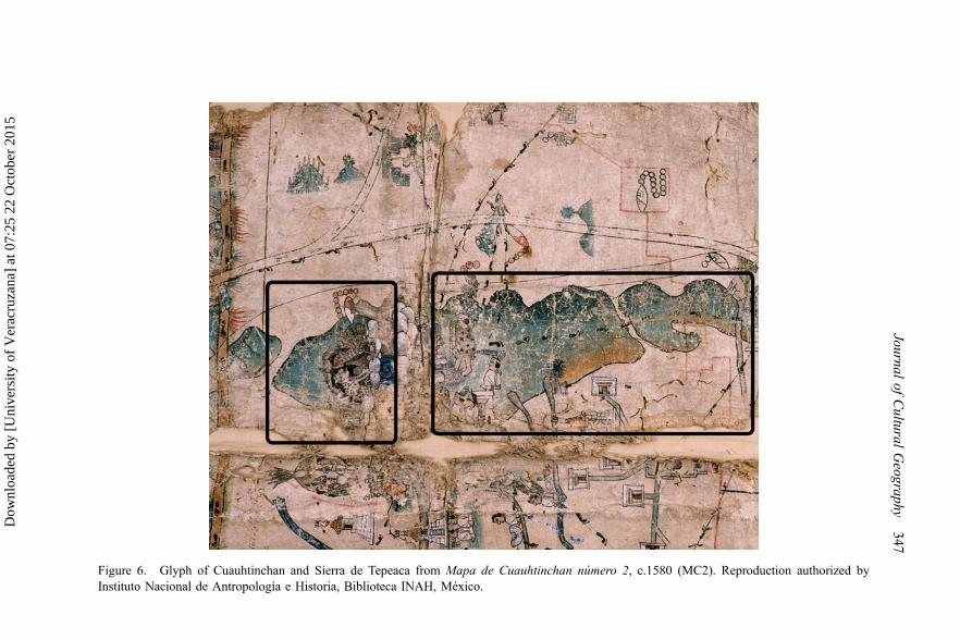
Figure 6. Glyph of Cuauhtinchan and Sierra de Tepeaca from Mapa de Cuauhtinchan número 2, c.1580 (MC2). Reproduction authorized byInstituto Nacional de Antropología e Historia, Biblioteca INAH, México.
Journalof
Cultural
Geography
347
Dow
nloa
ded
by [
Uni
vers
ity o
f V
erac
ruza
na]
at 0
7:25
22
Oct
ober
201
5
have chosen are better sources to discuss landscape. Georgina Enfield (2001)has studied the sixteenth-century lawsuits supported by maps representinglands in Michoacán, and a future work like hers for Cholula would be veryuseful.
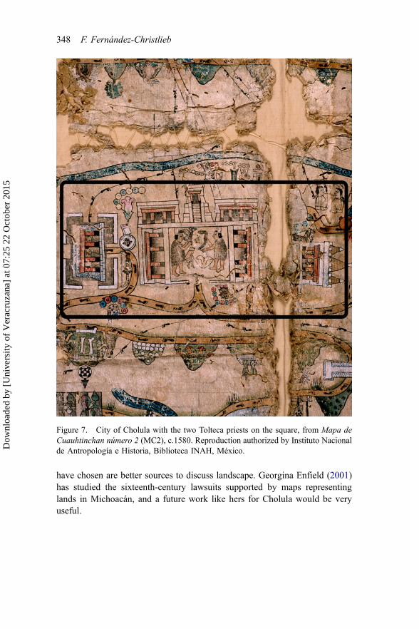
Figure 7. City of Cholula with the two Tolteca priests on the square, from Mapa deCuauhtinchan número 2 (MC2), c.1580. Reproduction authorized by Instituto Nacionalde Antropología e Historia, Biblioteca INAH, México.
348 F. Fernández-Christlieb
Dow
nloa
ded
by [
Uni
vers
ity o
f V
erac
ruza
na]
at 0
7:25
22
Oct
ober
201
5
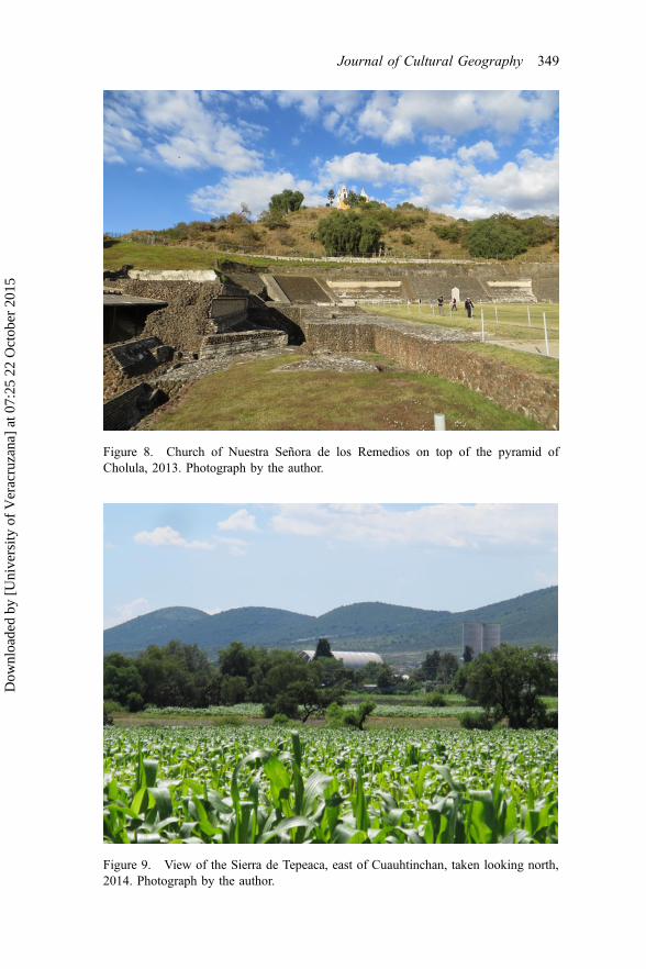
Figure 8. Church of Nuestra Señora de los Remedios on top of the pyramid ofCholula, 2013. Photograph by the author.
Figure 9. View of the Sierra de Tepeaca, east of Cuauhtinchan, taken looking north,2014. Photograph by the author.
Journal of Cultural Geography 349
Dow
nloa
ded
by [
Uni
vers
ity o
f V
erac
ruza
na]
at 0
7:25
22
Oct
ober
201
5

Representation of community
The glyph of altepetl ultimately represents the community (Mundy 1996). Inthe case of Cholula, the glyph painted in 4HTCh (Figure 2) has a frog on topof a hill: it is “the place where the water jumps” (Bernal-García 2006, p. 252),probably named after one of the water sources that still exists at the site(Carrasco and Sessions 2010). It also has a bunch of tules (reeds) that evokethe time when Cholula was ruled by the Toltecs and the name of the city wasTollan-Chollolan (Leibsohn 2009). Reeds also represent a populated city;Cholula was one of the largest concentrations of people in pre-Hispanic times(Cortés 1970; Díaz del Castillo 1998). The glyph of Cholula in RG (Figure 3)took the image of the tules from that tradition in order to design the glyph in adifferent way: the hill surrounded by reeds with a trumpet on the summit. Thetrumpet reminds us of the sound produced by snail shells that Spaniards foundburied on top of the main pyramid of Cholula after the destruction of thetemple that existed there. On the painting, the Cholula pyramid is alsothe glyph; I mark it with a “T” in Figure 3. The aim of RG is to explain theorganization of the surviving communities of Cholula’s confederation after the1519 war and the epidemics of 1540 and 1576 (Kubler 1968; Rojas 1985;Kubler 1968).
The most important role that this kind of map plays for the community isto provide its members with an identity based in history, in myth, or both. TheMC2 (Figure 4) is the chronicle of two Toltec priests (bottom of Figure 2)travelling from Cholula to Chicomoztoc, the hill of the seven caves (Figure 5),a sort of cosmic mountain-womb where the seven legendary Nahua tribeswere born (Carrasco and Sessions 2010). The priests went there to ask theChichimec warriors for help to defeat the Olmeca-Xicalanca that governedCholula in the twelfth century. I indicate the journey of the priests with adotted line in Figure 4, and in Figure 5 it shows them entering the sevencaves. Then some Chichimecs migrated, enduring many painful ordeals, to thearea of Cholula. This amazing scene is represented in the left half of the MC2,and unfortunately I cannot dedicate space in this paper to describe it, but seeCarrasco and Sessions (2010). Once the Chichimecs helped the Toltecs todefeat their enemies in Cholula, they obtained lands in the same valley as areward (Yoneda 2008; Boone 2010); in that land the Chichimecs founded thealtepetl of Cuauhtinchan (Boone 2010) (Figure 6). As we see, part of thenarrative happened in real places and another part happened in mythologicalplaces: both parts constitute the sacred geography of the communities ofCholula and Cuauhtinchan to strengthen their identities (Montero-García2008). These identities were based in a specific territory and were protectedby customary law.
Representation of the law
In RG, the rotation of communal commitments and power is stated bynumbering every head town that forms part of the colonial hueyaltepetl of
350 F. Fernández-Christlieb
Dow
nloa
ded
by [
Uni
vers
ity o
f V
erac
ruza
na]
at 0
7:25
22
Oct
ober
201
5

Cholula. I have marked them with a larger number in Figure 3, because thereproduction is hard to decipher. These communities are: San MiguelTianguisnahuac (1), Santiago Mixquitla (2), San Juan Calvario Texpolco (3),Santa María Xixitla (4), San Pablo Tecama (5) and San Andrés Colomochco(6) (Kobayashi 2012). Every head town represents one altepetl, and each oneof them is symbolized by a little mountain with a number written on the top ofthe glyph corresponding to the turn in the order of succession (Mundy 1996).In addition, the region of Cholula played an important jurisdictional role inpre-Hispanic times. Cholula was the city to which rulers of many otheraltepetl came to celebrate trials and solve their legal disputes.
Cholula’s authorities were traditionally invested as judges (Rojas 1985).They were used to reading and writing these kinds of pinturas. After theconquest, the indigenous representations were used in trials and in landdisputes (Enfield 2001). The maps I am analysing are good examples of thejuridical cartography of the area (Boone 2010). The Historia ToltecaChichimeca (4HTCh and 5HTCh) is a document elaborated for Alfonso deCastañeda, lord of Cuauhtinchan, to demand that the Spanish authoritiesrecognise the pre-Hispanic boundaries of his altepetl (Leibsohn 2009). Theintention of MC2 is from the Chichimec perspective to remind the Spaniardsthat Cholula formally gave them their lands where they founded Cuauhtinchanin the twelfth century (Bernal-García 2006; Yoneda 2008).
Representation of the land
MC2 depicts the territory claimed by Cuauhtinchan; the boundary isrepresented as a path with human footprints. I highlighted this path with ablack line in Figure 4, but examples of footprints are more visible and moreextensive in Figures 6 and 7. The territory claimed by Cuauhtinchan coveredan extended portion of current State of Puebla up to the limits with Veracruz(east), Tlaxcala (north) and Guerrero (south). Two of the highest peaks ofCentral Mexico are included as limits: Pico de Orizaba and La Malinche. Allalong the border, the map describes the neighbouring altepetl, eachrepresented as a small hill. This map also depicts the landscape of the AtoyacRiver valley including the highest volcanoes on the western horizon:Popocatepetl and Iztaccihuatl. Showing the main peaks of the landscapegave Cuauhtinchan prestige. These volcanoes are marked in Figures 1 and 4.The most important city of the valley is also represented: Cholula (Figure 7).It is a religious and commercial regional centre where many roads and pathsconverge (Carrasco and Sessions 2010). In addition, no other city isrepresented in MC2 with such magnificent buildings. One of them is theTemple of Quetzalcóatl that in sixteenth century had more relevance than thehigh pyramid of Cholula itself (Lind 2008). When Spaniards conqueredCholula, they built the Monastery of San Gabriel over the ruins of the Templeof Quetzalcóatl (as seen in the centre of RG map, Figure 3). So MC2 is like atopographic map oriented to the north. In MC2, we can read the history of the
Journal of Cultural Geography 351
Dow
nloa
ded
by [
Uni
vers
ity o
f V
erac
ruza
na]
at 0
7:25
22
Oct
ober
201
5

community of Cuauhtinchan, and some of the political organization andthe boundaries they claimed according to that history. We can also read theenvironment and the most visible landforms.
The case of RG is different. It is not a topographic representation of theterritory but a scheme of communities forming the altepetl of Cholula in 1581.The six hills painted in the RG map are not “views” as Landschaft painterswould have understood them: they are glyphs of communities representingpieces of land, and all of them have in common that they are settled over flatland. The area where Cholula was founded is an alluvial plain with no hills.The horizon with the volcanoes is far away; the distance from Popocatepetl toPico de Orizaba is 150 km. One exception occurs in the centre of the city, butthat hill is an artificial one. Its name is Tlachihualtepetl (shown as a mountain-glyph in Figure 2 and marked with a “T” in Figure 3) that means “mountainmade by hand” (Solís et al. 2006). Indeed the glyph clearly represents a hillmade with bricks in another sixteenth-century map: the Códice de Cholula(González-Hermosillo and Reyes-García 2002). This is one of the largestpyramids ever built in human history, but at the time the Spaniards arrived thepyramid had lost its importance, and today it looks like a natural hill(Uruñuela y Ladrón de Guevara et al. 2009) (Figure 8).
As previously mentioned, the mountainous landscapes of Central Mexicowere the environmental basis of the Nahua cosmovision (Broda andBáez-Jorge 2001; López-Austin and López-Luján 2009). MC2 representsone of the core locations, Cholula and the surrounding area, where thiscosmovision was probably conceived (McCafferty 2008). In MC2, commu-nities and mountains are represented as stylized hills. The community ofCuauhtinchan, for instance, is represented as a stylized mountain in a range ofhills, that is at the same time the glyph (with a jaguar and an eagle in themouth of a cave in Figure 6) of the community whose territory is depicted inthe right half of MC2 (Figure 4). In one of the field trips to the region, I foundthat the silhouette of that range of hills, located towards the east of the moderntown of Cuauhtinchan, is astonishingly similar to the one represented in theMC2 (Figure 9). Some parts of MC2 are really like vistas of the landscapewhile others are more like pre-Hispanic codices.
Cholula is represented as the most urbanized spot on the map (Figure 7).The relationship between the Popocatepetl volcano and the city of Cholula inthe landscape was special. In the MC2, the only volcano with a smoke plumeis Popocatepetl, and in the pre-Hispanic landscape the other mountain thatused to emit smoke was the Tlachihualtepetl, the pyramid that had a templeon its summit where priests often performed sacrifices and rituals using fireand copal (resin). The Sierra Nevada mountain range in which Popocatepetl isthe most conspicuous peak is the regional source of water (Delgado-Granados2002), and it was worshiped as the main food provider as well. The pyramidof Cholula is the projection of the volcano (López-Austin and López-Luján2009). Through the year, the sun as seen from the top of that pyramid hidesbehind the Popocatepetl, and the pyramid is the last spot of the entire valley
352 F. Fernández-Christlieb
Dow
nloa
ded
by [
Uni
vers
ity o
f V
erac
ruza
na]
at 0
7:25
22
Oct
ober
201
5

illuminated by the sun (Carrasco and Sessions 2010). According to asixteenth-century source, the environment was perceived to focus on thepyramid as the theatre of many religious festivities (Durán 2002). Still todaythe pyramid and the church of Nuestra Señora de los Remedios built on top ofit is the object of many celebrations each year, attracting hundreds ofthousands of pilgrims (Knab-H 2012). The pyramid faces the volcano andthey appear to have a permanent dialogue, establishing a bond between natureand culture.
Conclusion
The concept of landscape emerged in some different European languagessimultaneously and coincides with the encounter between Western andMesoamerican cultures in the sixteenth century. The exception was Castilian,the language of the conquistadors and the consequent question this paper triedto answer was: what concepts were the Spaniards using to denote landscape?Many documents show that they used pueblo instead, which is not an exactsynonym. Nevertheless, I conclude that pueblo had a broader meaning thansimply “town” or “people” for the Habsburg’s bureaucrats who prepared theRG questionnaire in Spain. This questionnaire was conceived by chronicler-cosmographer López de Velasco under the supervision of Philippe II, and theking’s notion of Landschaft (as community, law and land) helped form thebasis of its 50 questions. The Crown wanted to know detailed informationabout the pueblos as communities, as subjects of law and as pieces of land. Onthe ground however, the interrogators had a narrower notion of pueblo, sothey supplemented it with words such as pago or país and some others (tierra,término, asiento) that I could not analyse in this paper. I also demonstrated therelevance of pintura as the representation of the Landschaft. On the one hand,we see that all the aspects of the German definition are present in practice, buton the other hand there is a lack of a proper term to capture the fullness of theconcept in Spanish.
The second question inquired about whether the Nahua had equivalentconcepts to landscape. This paper offers the notion of altepetl as an acceptablesynonym of Landschaft at least after the conquest. I have argued this bycomparing altepetl with the key elements of Landschaft defined by KennethOlwig: community, law and land. I supported this statement by analysing notonly the way the Nahua used the concept altepetl but also the way theyrepresented the three elements in paintings. The paintings I show allow me toconfirm the equivalence of the German and Nahua concepts after theconquest.
Geographers interested in paisaje may find here an examination of thebackground of the concept before it was coined. So far, research into theSpanish term has been guided by French discussions (Maderuelo 2006)ignoring the enormous field for research in the sixteenth century when theSpanish were transforming the landscape of the New World. Furthermore,
Journal of Cultural Geography 353
Dow
nloa
ded
by [
Uni
vers
ity o
f V
erac
ruza
na]
at 0
7:25
22
Oct
ober
201
5

scholars now have new elements to compare the definitions in Europeanlanguages with equivalent notions in Indigenous tongues. Of course, this isnot the first time that a geographer has stated that in other traditional culturesthe notion of landscape existed before the sixteenth century. Augustin Berquehas shown us how the Chinese used this concept long before the Europeansand, by a striking coincidence, the Chinese term Suonging also meant “water-mountain” (Berque 1995), just like altepetl.
AcknowledgmentsThis article is part of a broader research sponsored by the National AutonomousUniversity of Mexico’s (UNAM) D.G.A.P.A., in four different stages: research at theUniversity of Texas at Austin (2006), sabbatical at the University of Sussex (2008–2009), research project Saberes locales y manejo de la diversidad ecogeográfica enáreas rurales de tradición indígena funded through UNAM’s Center of Research onEnvironmental Geography (2008–2011), and research project Paisaje y conflicto encomunidades de tradición indígena funded by PAPIIT (IN302115). Luis FernandoGopar Merino produced the map of the Cholula area for this article and drew theFigures 3, 4, 6 and 7. Javier Pérez Siller kept a photographic record of the sun’s transit.Thanks to Alejandro Velázquez for his remarks and to Dora Napolitano for hercomments and supervision of my English version. Very important amendments havebeen suggested by the reviewers and editors of JCG. Many thanks to Raquel Urroz forher discussions, the readings and images provided. I am particularly grateful toMarcelo Ramírez who invited me to do research on this subject many years ago andwho shared with me his latest investigations for this paper. Thanks also to UNAM’sInstitute of Geography, UNAM’s School in Canada and UNAM’s Centre of MexicanStudies in Paris.
Notes
1. Some linguistic clarifications are in order. I use “Castilian” and “Spanish” assynonyms in terms of language although in the sixteenth century they were not yetthe same. I use the German term Landschaft (plural: Landschaften) as a gloss for thevarious equivalents in Germanic languages, such as Landschap, which is theequivalent term in Flemish. Finally, “Nahuatl” is the language of the Aztecs orMexicas; “Nahua” is the adjective and the name of its ethnic group (plural:“Nahuas”).
2. For this case study, I visited Cholula, Cuauhtinchan, Tepeaca and other neighbour-ing towns several times between 2012 and 2014. I met with local people to learnabout their views and the place names of the surrounding landscape. I amparticularly grateful to Señora Verónica and Señora Clotilde in Tepeaca and toErasmo Velázquez in Cuauhtinchan.
3. There are geographers who have analysed the modern Spanish concept of paisaje(Bolós 1992; García-Romero and Muñoz-Jiménez 2002) but none of them go as faras the sixteenth century to examine the roots of the term and the background fromwhich it was conceived. A good analysis has been written by Javier Maderuelo(2006) from a pictorial point of view.
4. Historians have explained that Flemish and Dutch influences over the Spanishadministration started long before the Habsburgs gained power (Jago 1981; Lovet1986; Espinosa 2009). Nevertheless, when Charles arrived for his first visit to Spain
354 F. Fernández-Christlieb
Dow
nloa
ded
by [
Uni
vers
ity o
f V
erac
ruza
na]
at 0
7:25
22
Oct
ober
201
5

in 1517, he was impressed by the “Spanish rusticity” (Nader 1988, p. 301). After hebecame Holy Roman Emperor, he and later his son Philip II had to negotiatepermanently with the courts, the Church and the Spanish elites.
5. All translations were made by the author.6. The word pueblo had and still has these two meanings in Spanish: “town” and
“people”. One example from our case study is this: in the text of the RG of Cholulaof 1581, Gabriel de Rojas, the Spanish Authority in Cholula writes that “HernandoCortés … al tiempo que venía a descubrir la ciudad de México, llegó a este pueblo ”[Hernando Cortes … when he came to discover the city of Mexico, arrived at thistown (emphasis added)] (Rojas 1985, p. 125) and a few paragraphs later “a esteídolo … le hacían una fiesta general cada año, donde concurría todo el pueblo”[… they prepared a festivity to this idol each year, which all the people attended(emphasis added)] (p. 132).
7. Cities like Tenochtitlan, Cholula or Huexotzingo were famous for their size anddemography in pre-Columbian times, but they were rather exceptional. Most of theindigenous population used to live scattered on rural lands (Ramírez-Ruiz 2006).
8. There were Flemish painters in Mexico, some of them painting in indigenoustowns: Simon Pereyns arrived in 1566 and Adrian Suster arrived in 1573, but noneof them represented landscapes (Toussaint 1948; Kubler 1984). In 1571, Philip IIsent to New Spain a Portuguese cosmographer called Francisco Domínguez torepresent cities and towns, but there is no evidence of his work (Mundy 1996).
References
Acosta, J.D., 2003. Historia natural y moral de las Indias. Madrid: Dastin.Acuña, R., ed., 1986. Relaciones Geográficas del siglo XVI: Tlaxcala. México: UNAM.AGN, 1617. Diligencias sobre un sitio de estancia para ganado menor en tierras de
Ecatzingo Y S. Miguel Atataco que pidió por merced el casique D. Pedro Alvarado,Tierras, vol. 2677, exp. 6.
Albores, B. and Broda, J., 1997. Graniceros: cosmovisión y meteorología indígenas deMesoamérica. México: UNAM/El Colegio Mexiquense.
Alfonso-X, 1974. Las siete partidas del sabio rey don Alfonso. Madrid: Andrea dePortonaris/Boletin oficial del Estado.
Alonso, M., 1986. Diccionario medieval español. Salamanca: Universidad Pontificiade Salamanca.
Avocat, C., 1982. Approche du Paysage. Revue de Géographie de Lyon, 1982 (4),333–342.
Bernal-García, M.-E., 2006. Tu agua, tu cerro, tu flor: orígenes y metamorfosisconceptuales del altepetl de Cholula, siglos XII y XVI. In: F. Fernández-Christlieband A.J. García-Zambrano, eds. Territorialidad y paisaje en el altepetl del siglo XVI.Mexico: Fondo de Cultura Económica/Instituto de Geografía, UNAM, 231–349.
Bernal-García, M.-E. and García-Zambrano, A.-J., 2006. El altepetl colonial y susantecedentes prehispánicos: contexto teórico-historiográfico. In: F. Fernández-Christlieb and A.-J. García-Zambrano, eds. Territorialidad y paisaje en el altepetldel siglo XVI. México: Fondo de Cultura Económica/Instituto de Geografía, UNAM,31–113.
Berque, A., 1984. Paysage-empreinte, paysage-matrice: éléments de problématiquepour une géographie culturelle. L’espace géographique, 19 (1), 334.
Journal of Cultural Geography 355
Dow
nloa
ded
by [
Uni
vers
ity o
f V
erac
ruza
na]
at 0
7:25
22
Oct
ober
201
5

Berque, A., 1990. Médiance, de milieux en paysages. Montpellier: GéographiquesReclus.
Berque, A., 1995. Les raisons du paysage: de la Chine antique aux environnements desynthèse. Paris: Hazan.
Berque, A., 2000. Écoumène, introduction à l'étude des milieux humains. Paris: Belin.Blázquez-Garbajosa, A., 1983. La población de la provincia de Guadalajara a la luz de
la Relaciones topográficas de Felipe II (1575–1581). Wad-Al-Hayara: revista deestudios de Guadalajara, 10, 117–136.
Bolós, M.D., 1992. Manual de la ciencia del paisaje: teoría, métodos y aplicaciones.Barcelona: Masson.
Bonfil-Batalla, G., 1988. Cholula: la ciudad sagrada en la era industrial. Puebla:Universidad Autónoma de Puebla.
Boone, E.H., 2010. La casa del Águila. In: D. Carrasco and S. Sessions, eds. Cueva,ciudad y nido de Águila: una travesía interpretativa por el mapa de Cuauhtinchannúm. 2. Alburquerque: University of New Mexico Press, 27–47.
Boornazian-Diel, L., 2012. El manuscrito del aperreamiento. Castigos abominables.Arqueología Mexicana, 71–73.
Broda, J. and Báez-Jorge, F., 2001. Cosmovisión, ritual e identidad de los pueblosindígenas de México. Mexico: Fondo de Cultura Económica.
Broda, J., Iwaniszewski, S., and Maupomé, L., eds., 1991. Arqueoastronomía yetnoastronomía en Mesoamérica. Mexico: Instituto de Investigaciones Histór-icas UNAM.
Brown, C., 1972. Dutch townscape painting. London: National Gallery.Carrasco, D. and Sessions, S., 2010. “Lugar del Medio,” laberinto y circunvalación. El
papel peripatético de Cholula en el Mapa de Cuauhtinchan núm. 2. In: D. Carrascoand S. Sessions, eds. Cueva, ciudad y nido de Águila: una travesía interpretativapor el mapa de Cuauhtinchan núm. 2. Alburquerque: University of New MexicoPress, 427–453.
Carrasco, R., 2005. Charles Quint. Paris: Ellipses.Chanfón-Olmos, C., 1997. Historia de la arquitectura y del urbanismo en México.
México: Facultad de Arquitectura UNAM.Chávez-Peón-Herrero, A.E., Garza-Merodio, G., and Fernández-Christlieb, F., 2010.
Pintura de Atlatlauca, 1588. In: F. Roque de Oliveira and H. Mendoza-Vargas, eds.Mapas de metade do mundo: a cartografia e a costrucao dos territoriosamericanos, seculos XVI a XIX. Lisboa/México: Universidade de Lisboa/UNAM,131–148.
Claval, P., 2003. La géographie culturelle: une nouvelle approche des sociétés et desmilieux. Paris: Armand Colin.
Claval, P., 2012. De la terre aux hommes: la géographie comme vision du monde.Paris: Armand Colin.
Cline, H.F. 1972. The Relaciones Geograficas of the Spanish Indies, 1577–1648. In:R. Wauchope, ed. The handbook of Middle American Indians. Austin: University ofTexas Press, 183–242.
Corominas, J., 1983. Breve diccionario etimológico de la lengua castellana. Madrid:Gredos.
Corominas, J. and Pascual, J.A., 1981. Diccionario crítico etimológico castellano ehispánico. Madrid: Gredos.
Cortelazzo, M. and Zolli, P., 1999. Il nuovo dizionario etimologico della linguaItaliana. Bologna: Zanichelli.
356 F. Fernández-Christlieb
Dow
nloa
ded
by [
Uni
vers
ity o
f V
erac
ruza
na]
at 0
7:25
22
Oct
ober
201
5

Cortés, H. 1970. Cartas de Relación. México: Porrúa.Cosgrove, D., 2002. Observando la naturaleza: el paisaje y el sentido europeo de la
vista. Boletín de la A.G.E., 34, 63–89.Cosgrove, D.E., 1984. Social formation and symbolic landscape. London:
Croom Helm.Covarrubias-Orozco, S.D., 1979. Tesoro de la lengua castellana, o española. Madrid:
Clásicos Tavera.Crespo-Sanz, A., 2005. Un mapa olvidado: el Atlas de El Escorial. Catastro, 55,
59–89.Crespo-Sanz, A., 2009. El Atlas de El Escorial. Ciudades, Universidad de Valladolid,
12, 251–264.Crosby, A.W., 1976. Virgin soil epidemics as a factor in the aboriginal depopulation in
America. The William and Mary Quarterly, 33 (2), 289–299.Crosby, A.W., 2007. Ecological imperialism: the biological expansion of Europe, 900–
1900. Cambridge: Cambridge University Press.Delgado-Granados, H., 2002. Los volcanes de México. Mexico: Universidad Nacional
Autónoma de México.Deylen, W.V., 2003. Ländliches Wirtschaftsleben im spätkolonialen Mexiko. Eine
mikrohistorische Studie in einem multiethnischen Distrikt: Cholula 1750–1810.Hamburg: Hamburg University Press.
Díaz del Castillo, B., 1998. Historia verdadera de la conquista de la Nueva España.México: Porrúa.
Donadieu, P., 2006. La sociedad paisajista. La Plata: Universidad de La Plata.Duncan, J.S., 1990. The city as a text: the politics of landscape interpretation in the
Kandyan kingdom. Cambridge: Cambridge University Press.Durán, D., 2002. Historia de las Indias de Nueva España e Islas de Tierra Firme
(Tomo II). México: Consejo Nacional para la Cultura y las Artes.Enfield, G.H., 2001. Pinturas, land and lawsuits: maps in Colonial Mexican legal
documents. Imago Mundi, 53, 7–27.Escalante, P., 2004. La ciudad, la gente y las costumbres. In: P. Gonzalbo-Aizpuru, ed.
Historia de la vida cotidiana en México I: Mesoamérica y los ámbitos indígenas dela Nueva España. Mexico: Fondo de Cultura Económica/El Colegio de México,199–230.
Espinosa, A., 2009. The empire of the cities: Emperor Charles V, the Comunero Revolt,and the transformation of the Spanish System. Leiden: Koninklijke Brill NV.
Fernández-Christlieb, F., et al., 2006. El altepetl de Metztitlán y su señorío colonialtemprano. In: F. Fernández-Christlieb and A.J. García-Zambrano, eds. Territoriali-dad y paisaje en el altepetl del siglo XVI. Mexico: Fondo de Cultura Económica/Instituto de Geografía UNAM, 479–530.
Fernández-Christlieb, F. and Urquijo-Torres, P.S., 2006. Los espacios del pueblo deindios tras el porceso de congregación, 1550–1625. Investigaciones Geográficas,Boletín del Instituto de Geografía, UNAM, 60, 145–158.
Florescano, E. 2009. Los orígenes del poder en Mesoamérica. México: Fondo deCultura Económica/Arqueología Mexicana.
Galarza, J., 1991. Lienzos o mapas aztecas. Manuscritos pictóricos mexicanos decontenido cartográfico. Chicomoztoc, 1991, 5–27.
Galera-I-Monegal, M., 1998. Antoon van den Wijngaerde, pintor de ciudades y dehechos de armas en la Europa del Quinientos. Cartobibliografía razonada de los
Journal of Cultural Geography 357
Dow
nloa
ded
by [
Uni
vers
ity o
f V
erac
ruza
na]
at 0
7:25
22
Oct
ober
201
5

dibujos y grabados, y ensayo de reconstrucción documental de la obra pictórica.Barcelona: Fundación Carlos de Amberes/Institut Cartogràfic de Catalunya.
García-Guerra, M.E. and Vicioso-Rodríguez, M.D.L.Á., 1993. Relaciones topográficasde Felipe II: Madrid, 4 volúmenes. Madrid: Consejería de Cooperación/Comunidadde Madrid.
García-Martínez, B., 2001. Community kingdoms: Central Mexico (Nahua). In:D. Carrasco, ed. The Oxford encyclopedia of Mesoamerican cultures. Oxford:Oxford University Press, 238–239.
García-Martínez, B., 2005. Los pueblos de la Sierra. El poder y el espacio entre losindios del norte de Puebla hasta 1700. Mexico: El Colegio de México.
García-Romero, A. and Muñoz-Jiménez, J., 2002. El paisaje en el ámbito de lageografía. México: Instituto de Geografía UNAM.
García-Zambrano, A.J., 2006. Pasaje mítico y paisaje fundacional en las migracionesmesoamericanas. Cuernavaca: Universidad Autónoma del Estado de Morelos.
Gerhard, P., 1977. Congregaciones de indios en la Nueva España antes de 1570.México: Historia Mexicana, 26, 347–395.
Gibson, C., 1983. The Aztecs under Spanish rule: a history of the Indians of the Valleyof Mexico 1519–1810. Stanford, CA: Stanford University Press.
González-Hermosillo, F. and Reyes-García, L., 2002. El códice de Cholula: laexaltación testimonial de un linaje indio. Puebla: INAH/CIESAS/Porrúa.
González-Hermosillo, F., 2012. Códice de Cholula. Arqueología Mexicana, 115 (1),66–70.
Gruffund, P., 2003. Building sites: cultural geographies of architecture and place-making. In: A. Blunt, ed. Cultural geography in practice. London: Arnold,238–254.
Haber, W., 1995. Concept, origin and meaning of landscape. In: B.V. Droste, ed.Cultural landscapes of universal value. Stuttgart: Gustav Fischer and UNESCO,38–41.
Haverkamp-Begemann, E., 1969. The Spanish views of Anton van den Wyngaerde.Master Drawings, 7, 375–399 & 438–450.
Hicks, F., 2012. Governing smaller communities in Aztec Mexico. Ancient Mesoamer-ica, 23 (1), 47–56.
Jackson, J.B., 2008. The word itself. In: T.S. Oakes and P.L. Price, eds. The culturalgeography reader. London: Routledge, 153–158.
Jago, C., 1981. Habsburg absolutism and the Cortes of Castile. The AmericanHistorical Review, 86 (2), 307–326.
Kagan, R.L., 2000. Urban images of the Hispanic world 1493–1793. New Haven, CT:Yale University Press.
Kagan, R.L., 2008. Las ciudades del siglo de oro: las vistas españolas de Anton vanden Wingaerde. Madrid: Ediciones El Viso.
Kamen, H., 2003. Spain’s road to empire: the making of a world power 1492–1763.London: Penguin Books.
Knab-H, T.J., 2012. Reinventing the millennial myth: the great pyramid of Cholula andthe virgin of the remedies. In: S. Sugiyama, S. Kabata, T. Taniguchi, and E. Niwa,eds. Constructing, deconstructing and reconstructing social identity: 2000 years ofmonumentality in Teotihuacan and Cholula, Mexico. Aichi: Cultural SymbiosisResearch Institute/Aichi Prefectural University, 107–118.
Kobayashi, T., 2012. History engraved on the urban landscape: formation of the sacredcity and construction of traditional festivals in Cholula, Mexico. In: S. Sugiyama, S.
358 F. Fernández-Christlieb
Dow
nloa
ded
by [
Uni
vers
ity o
f V
erac
ruza
na]
at 0
7:25
22
Oct
ober
201
5

Kabata, T. Taniguchi, and E. Niwa, eds. Constructing, deconstructing andreconstructing social identity: 2000 years of monumentality in Teotihuacan andCholula, Mexico. Aichi: Cultural Symbiosis Research Institute/Aichi PrefecturalUniversity, 119–132.
Kubler, G., 1968. La traza colonial de Cholula. Estudios de Histroria Novohispana, 2,1–30.
Kubler, G., 1984. Arquitectura mexicana del siglo XVI. México: Fondo de CulturaEconómica.
Leibsohn, D. 2009. Script and glyph: pre-Hispanic history, colonial bookmaking andthe Historia Tolteca-Chichimeca. Washington, DC: Dumbarton Oaks.
Licate, J.A., 1980. The forms of Aztec territorial organization. Geoscience and Man,XXI, 27–45.
Licate, J.A., 1981. Creation of Mexican landscape: territorial organization andsettlement in the eastern Puebla Basin, 1520–1605. Chicago: The University ofChicago Department of Geography.
Lind, M., 2008. La Gran Cuadra de la ciudad: el gobierno prehispánico de Cholula.Arqueología, 39, 65–76.
Links, J.G., 1972. Townscape painting and drawing. London: Batsford.Lockhart, J., 1992. The Nahuas after the conquest. A social and cultural history of the
Indians of Central Mexico, sixteenth through eighteenth centuries. Stanford, CA:Stanford University Press.
López-Austin, A., 1989. Cuerpo humano e ideología: las concepciones de los antiguosnahuas. México: UNAM.
López-Austin, A., 1999. Tamoanchan y Tlalocan. México: Fondo de CulturaEconómica.
López-Austin, A. and López-Luján, L., 2009. Monte sagrado: Templo Mayor. México:Instituto Nacional de Antropología e Historia/Instituto de Investigaciones Antropo-lógicas-UNAM.
Lovet, A.W., 1986. Early Habsburg Spain 1517–1598. New York, NY: OxfordUniversity Press.
Maderuelo, J., 2006. El paisaje: génesis de un concepto. Madrid: Abada editores.Marcus, J., 2000. Towards an archaeology of communities. In: M.A. Canuto and
J. Yaeger, eds. The archaeology of communities: a new world perspective. London:Routledge, 231–242.
Martínez, H., 1984. Tepeaca en el siglo XVI. Tenencia de la tierra y organización deun señorío. México: SEP/CIESAS.
McCafferty, G.G., 2008. Altepetl: Cholula’s great pyramid as “water-mountain.” In:L. Steinbrenner, B. Cripps, M. Georgopulos, and J. Carr, eds. Flowing through time:exploring archaeology through humans and their aquatic environment. Calgary:University of Calgary Press, 20–25.
Melville, E.G.K., 1997. A plague of sheep. Environmental consequences of theconquest of Mexico. Cambridge: Cambridge University Press.
Mitchell, D. 2007. Landscape. In: D. Atkinson, P. Jackson, D. Sibley, and N.Washbourne, eds. Cultural geography: a critical dictionary of key concepts.London: Tauris, 49–56.
Molina, A.D., 2001. Vocabulario en lengua castellana y mexicana y mexicana ycastellana. México: Porrúa.
Journal of Cultural Geography 359
Dow
nloa
ded
by [
Uni
vers
ity o
f V
erac
ruza
na]
at 0
7:25
22
Oct
ober
201
5

Montero-García, I.-A., 2008. Apuntes al Mapa de Cuauhtinchan II desde la geografíasimbólica. In: T. Tucker and A. Montero, eds. Mapa de Cuauhtinchan II: entre laciencia y lo sagrado. Puebla: Mesoamerican Research Foundation, 91–144.
Mundy, B., 1996. The mapping of the New Spain: Indigenous cartography and themaps of the Relaciones Geográficas. Chicago: University of Chicago Press.
Nader, H., 1988. Habsburg ceremony in Spain: the reality of the myth. HistoricalReflections/Réflexions Historiques, 15, 293–309.
Noguez, X., 2001. Altepetl. Oxford encyclopedia of Mesoamerican cultures. Oxford:Oxford University Press.
O’Connor, L. and Kroefges, P.C., 2008. The land remembers: landscape terms andplace names in lowland Chontal of Oaxaca, Mexico. Language Sciences, 30 (2),291–315.
Olwig, K.R., 1996. Recovering the substantive nature of landscape. Annals of theAssociation of American Geographers, 86 (4), 630–653.
Olwig, K.R., 2002. Landscape, nature, and the body politic. Madison: University ofWisconsin Press.
Portuondo, M.M., 2009. Secret science: Spanish cosmography and the new world.Chicago: University of Chicago Press.
Ramírez-Ruiz, M., 2006. Territorialidad, pintura y paisaje del Pueblo de Indios. In: F.Fernández-Christlieb and A.J. García-Zambrano, eds. Territorialidad y paisaje en elaltepetl del siglo XVI. Mexico: Fondo de Cultura Económica/Instituto de GeografíaUNAM, 168–227.
Ramírez-Ruiz, M. and Fernández-Christlieb, F., 2006. La policía de los indios y laurbanización del altepetl. In: F. Fernández-Christlieb and A.J. García-Zambrano,eds. Territorialidad y paisaje en el alteptl del siglo XVI. México: Fondo de CulturaEconómica/Instituto de Geografía UNAM, 114–167.
Real Academia de la Historia. 1737. Diccionario de la lengua castellana,en que seexplica el verdadero sentido de las voces, su naturaleza y calidad, con las phrases omodos de hablar, los proverbios o refranes, y otras cosas convenientes al uso de lalengua. Madrid: Colección Clásicos Tavera.
Real Academia Española. 1992. Diccionario de la lengua Española. Madrid: RealAcademia Española.
Relph, E., 1981. Rational landscape and humanistic geography. Totowa, NJ:Croom Helm.
Reyes-García, C., 2000. El Altepetl, origen y desarrollo: construcción de la identidadregional náhuatl. Zamora: El Colegio de Michoacán.
Roger, A., 1997. Court traité du paysage. Paris: Gallimard.Rojas, G.D., 1985. Relación Geográfica de Cholula. In: R. Acuña, ed. Relaciones
Geográficas del siglo XVI. Tlaxcala. México: UNAM, 125–145.Russo, A., 2005. El realismo circular: tierras, espacios y paisajes de la cartografía
novohispana, siglos XVI y XVII. México: Instituto de Investigaciones Estéti-cas UNAM.
Sahagún, B.D., 1999. Historia general de las cosas de la Nueva España. México:Porrúa.
Sartor, M., 1992. Arquitectura y urbanismo en Nueva España, siglo XVI. México:Azabache.
Sauer, C. 2008. The morphology of landscape. In: T.S. Oakes and P.L. Price, eds. Thecultural geography reader. New York, NY: Routledge, 96–104.
Sevilla, I.D., 1994. Etimologías. Madrid: Biblioteca de Autores Cristianos.
360 F. Fernández-Christlieb
Dow
nloa
ded
by [
Uni
vers
ity o
f V
erac
ruza
na]
at 0
7:25
22
Oct
ober
201
5

Solís, F., et al., 2006. Cholula: la gran pirámide. México: CONACULTA/INAH/Azabache.
Solórzano y Pereyra, J., 1930. Política indiana. Madrid/Buenos Aires: CompañíaIbero-Americana de Publicaciones.
Staller, J.E., ed., 2008. Pre-columbian landscapes of creation and origin. New York,NY: Springer.
Tilley, C., 1994. A phenomenology of landscape. Places, paths and monuments.Providence, RI: Berg.
Torre-Villar, E.D.L., 1995. Las congregaciones de los pueblos de indios. Faseterminal: aprobaciones y rectificaciones. México: Instituto de InvestigacionesHistóricas UNAM.
Toussaint, M., 1948. Arte colonial en México. Mexico: Imprenta Universitaria.Uruñuela y Ladrón de Guevara, G., Plunket-Nagoda, P., and Robles-Salmerón, A.,
2009. Art and architecture of an archetypal city. In: W.L. Flash and L. López-Luján,eds. The art of urbanism. How Mesoamerican kingdoms represented themselves inarchitecture and imagery. Washington, DC: Dumbarton Oaks Research Library,133–171.
Wood, S., 2012. Transcending conquest: Nahua views of Spanish Colonial Mexico.Norman: University of Oklahoma Press.
Yoneda, K., 2008. Proyecto los mapas de Cuauhtinchan. De la historia cartográfica a lacultura chichinmeca. In: T. Tucker and A. Montero, eds. Mapa de Cuauhtinchan IIentre la ciencia y lo sagrado. Puebla: Mesoamerican Research Foundation, 1–26.
Journal of Cultural Geography 361
Dow
nloa
ded
by [
Uni
vers
ity o
f V
erac
ruza
na]
at 0
7:25
22
Oct
ober
201
5