landslide susceptibility near highways is increased by 1 ... · pdf filehighways troncal de la...
TRANSCRIPT
Nat. Hazards Earth Syst. Sci., 15, 45–57, 2015
www.nat-hazards-earth-syst-sci.net/15/45/2015/
doi:10.5194/nhess-15-45-2015
© Author(s) 2015. CC Attribution 3.0 License.
Landslide susceptibility near highways is increased by 1 order
of magnitude in the Andes of southern Ecuador, Loja province
A. Brenning1,2, M. Schwinn3, A. P. Ruiz-Páez1,4, and J. Muenchow3
1Department of Geography and Environmental Management, University of Waterloo, Waterloo, Ontario, Canada2Department of Geography, University of Jena, Löbdergraben 32, 07737 Jena, Germany3Institute of Geography, University of Erlangen-Nuremberg, Kochstr. 4/4, 91054 Erlangen, Germany4Instituto de Geografía, Pontificia Universidad Católica de Chile, Santiago, Chile
Correspondence to: A. Brenning ([email protected])
Received: 21 January 2014 – Published in Nat. Hazards Earth Syst. Sci. Discuss.: 6 March 2014
Revised: 4 December 2014 – Accepted: 4 December 2014 – Published: 7 January 2015
Abstract. Mountain roads in developing countries are known
to increase landslide occurrence due to often inadequate
drainage systems and mechanical destabilization of hill-
slopes by undercutting and overloading. This study empir-
ically investigates landslide initiation frequency along two
paved interurban highways in the tropical Andes of southern
Ecuador across different climatic regimes. Generalized ad-
ditive models (GAM) and generalized linear models (GLM)
were used to analyze the relationship between mapped land-
slide initiation points and distance to highway while account-
ing for topographic, climatic, and geological predictors as
possible confounders. A spatial block bootstrap was used to
obtain nonparametric confidence intervals for the odds ratio
of landslide occurrence near the highways (25 m distance)
compared to a 200 m distance. The estimated odds ratio was
18–21, with lower 95 % confidence bounds > 13 in all anal-
yses. Spatial bootstrap estimation using the GAM supports
the higher odds ratio estimate of 21.2 (95 % confidence inter-
val: 15.5–25.3). The highway-related effects were observed
to fade at about 150 m distance. Road effects appear to be en-
hanced in geological units characterized by Holocene gravels
and Laramide andesite/basalt. Overall, landslide susceptibil-
ity was found to be more than 1 order of magnitude higher in
close proximity to paved interurban highways in the Andes
of southern Ecuador.
1 Introduction
Anthropogenic denudation has increased exponentially over
the last decades and now exceeds natural denudation by
several orders of magnitude (Cendrero et al., 2006). Ac-
cordingly, human activity has also become a major factor
in increasing landslide susceptibility. It affects the inten-
sity and frequency of landsliding globally through global
warming and enhanced precipitation (Crozier, 2010), and lo-
cally especially through land cover changes (Glade, 2003)
and constructions (Dikau et al., 1996). Deforestation and
roads in particular seem to enhance the likelihood of mass
movement occurrence (Glade, 2003; Goetz et al., 2011). In-
creased landslide activity in the vicinity of populated areas
and transportation infrastructure may lead to human catas-
trophes (Fassin and Vasquez, 2005) and vast economic dam-
age (Vranken et al., 2013). Tropical mountain ecosystems
are especially sensitive and respond quickly to any change
(Vanacker et al., 2007). In the Andes of southern Ecuador, ac-
celerated human pressure has increased sediment yield man-
ifold (Molina et al., 2008), and areas adjacent to highways
have proved to be most susceptible to landsliding (Muen-
chow et al., 2012).
Scientific research may, therefore, contribute to prevent-
ing such catastrophes by providing policy makers with maps
of high landslide potential and information regarding pos-
sible implications of construction along hillsides in high-
mountain areas. Inadequate design of drainage systems and
the mechanical destabilization by undercutting and overload-
ing are typical problems related to mountain roads in de-
Published by Copernicus Publications on behalf of the European Geosciences Union.
46 A. Brenning et al.: Landslide susceptibility near highways is increased by 1 order of magnitude in the Andes
veloping countries but which also affect unimproved roads
in developed countries (Sidle and Ochiai, 2006). Empirical–
statistical models of landslide susceptibility are an efficient
and effective means of identifying areas of high suscepti-
bility to landsliding, as well as quantitatively measuring the
increase in the odds of landslide occurrence that is associ-
ated with known or hypothesized risk factors such as high-
ways while accounting for environmental confounding fac-
tors (Brenning, 2012a). Among the challenges encountered
in the application of these models is the possible presence of
nonlinear relationships and the need to deal with spatial auto-
correlation, especially when trying to provide confidence in-
tervals for the estimated odds ratios (Brenning, 2012a, 2005;
Goetz et al., 2011; Vorpahl et al., 2012).
The objective of this study is to estimate the difference
in landslide susceptibility in close proximity versus greater
distance to paved interurban highways in the tropical An-
des of southern Ecuador along a climatic gradient. For this
purpose, data from a landslide inventory compiled within a
300 m corridor along these highways were analyzed using
generalized additive models (GAM) and generalized linear
models (GLM) in order to empirically estimate the effect of
highways on landslide initiation while accounting for possi-
ble topographic, climatic, and geological confounders. The
dependence of the relationship between highway distance
and landslide initiation on other environmental factors is fur-
ther examined.
2 Data and methods
2.1 Study area
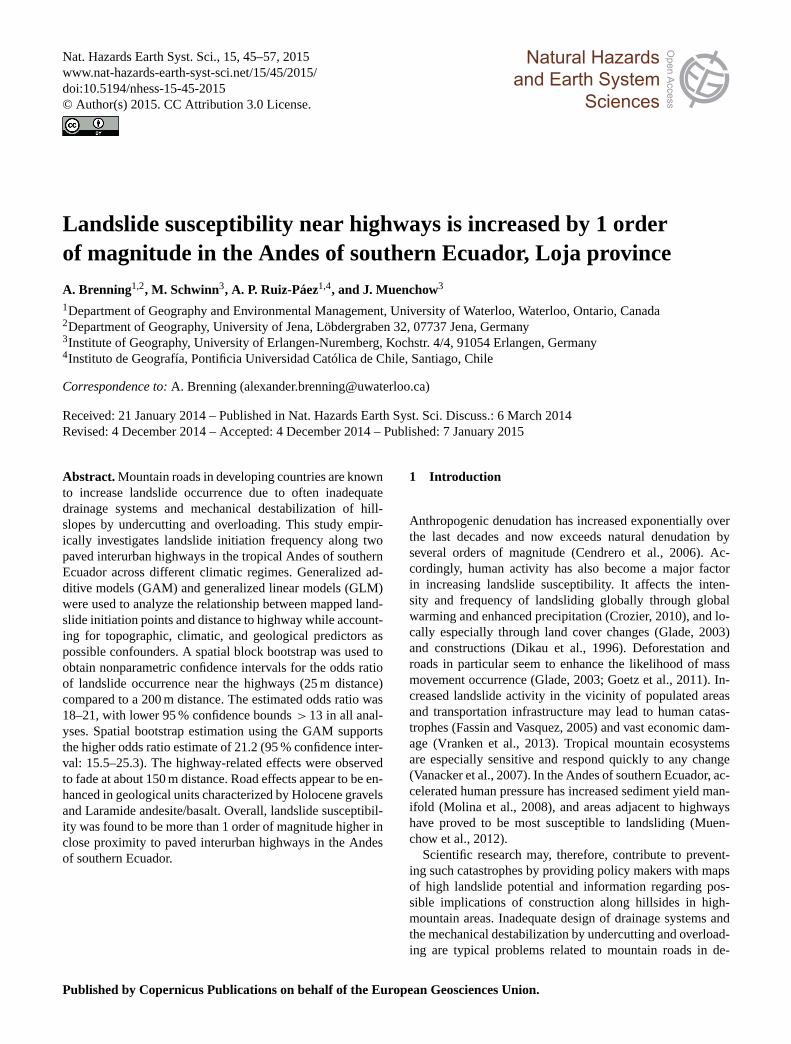
Our study area is the 300 m buffer on both sides of paved
interurban two-lane highways of the Loja and the Zamora-
Chinchipe provinces in southern Ecuador (highways Tron-
cal de la Sierra E35 and Transversal Sur E50 (Fig. 1). The
buffer zone comprises 88 km2 within a bounding box of
51 km× 47 km.
The Cordillera Real runs midway through the study area,
and as a climate divide it strongly shapes mean annual pre-
cipitation patterns within the study area (Beck et al., 2008).
Tropical easterlies are forced to ascend the eastern escarp-
ment which results in values> 6000 mm (Rollenbeck and
Bendix, 2011). After passing the main ridge, massive föhn
walls develop, which leads to dry conditions west of the main
divide. The area around Catamayo in particular is charac-
terized by a dry climate (< 400 mm rainfall per year; Rol-
lenbeck and Bendix, 2011). Vegetation patterns reflect this
strong climatic gradient. Tropical dry forest formations dom-
inate the west, and páramo formations and tropical mountain
and cloud forests the east (Muenchow et al., 2012; Peters et
al., 2010).
The area’s surficial geology is furthermore divided into
two main units, namely metamorphic rocks and sedimentary
Figure 1. Overview of the study area with mean annual precipita-
tion patterns (top panel), and its location in southern Ecuador (lower
left panel). Highways Troncal de la Sierra E35 and Transversal
Sur E50 extend in the north–south and east–west direction, respec-
tively. The numbers along the street refer to the corresponding geo-
logical unit (1: unconsolidated rocks; 2: sedimentary rocks; 3: vol-
canic rocks; 4: metamorphic rocks; 5: plutonic rocks). The area of
the detailed map (lower right panel) will be used as a sample area
for the visualization of a predictive map in Fig. 5. Precipitation data
are taken from the study of Rollenbeck and Bendix (2001).
rocks. The strike of the metamorphic rock is north–south
with a slight dip to the east. Moreover, the metamorphic
rocks exhibit an orthogonal joint set, and are frequently in-
terspersed with layers of highly weathered phyllite and clay
schist (Beck et al., 2008; Muenchow et al., 2012). Metamor-
phic rocks prevail in large parts of the study area along the
highways. The inter-Andean Sierra, in contrast, served as a
sediment trap, resulting in conglomeratic and sandstone for-
mations (Litherland et al., 1994; Beck et al., 2008). These
sedimentary rocks almost always exhibit a horizontal layer-
ing in conjunction with an orthogonal joint set (Muenchow
et al., 2012).
Land use is visible throughout the study area, with some
differentiation according to local climate (Beck et al., 2008).
Many hillslopes have been deforested and converted into pas-
Nat. Hazards Earth Syst. Sci., 15, 45–57, 2015 www.nat-hazards-earth-syst-sci.net/15/45/2015/
A. Brenning et al.: Landslide susceptibility near highways is increased by 1 order of magnitude in the Andes 47
ture, while the fertile valleys of the inter-Andean Sierra are
used to grow, for example, bananas, coffee, and sugar cane
(Pohle et al., 2013; Rodríguez et al., 2013). Podocarpus Na-
tional Park is a nearby major protected area; however, it only
overlaps with our study area locally in the surroundings of
the El Tiro pass (Fig. 1). The smaller Reserva Biológica San
Francisco (located in the surroundings of the Estación Cien-
tífica San Francisco in Fig. 1) is near the road but presents
land use and deforestation in proximity to the highway.
2.2 Data
All landslides occurring within a 300 m corridor along
the highways were mapped by M. Schwinn during several
months of field work in 2010 as well as from an orthorecti-
fied aerial photograph of the year 2000 (scale 1 : 5000, reso-
lution of orthoimage 1 m× 1 m; data source: E. Jordan and
L. Ungerechts, Düsseldorf). The following attributes were
recorded for all field-mapped landslides: type of movement
(classification is in accordance with Dikau et al., 1996), ma-
terial type (soil, debris, rock), and state of activity (Cruden
and Varnes, 1996). These classifications are available for
all landslides observed along the highways in the field
(843 movements) but not for the other slides within the 300 m
buffer. All movements were subsequently digitized as poly-
gons from the aerial photograph.
Landslide initiation points were manually digitized by se-
lecting a point in the central part of the uppermost portion
of each landslide polygon in order to represent its detach-
ment zone (Muenchow et al., 2012; Goetz et al., 2011). Over-
all, 2185 landslide initiation points are available within the
300 m buffer for this study. Since only 47 field-mapped land-
slides were not visible in the aerial photographs, and given
the high image resolution, we consider the inventory to be
complete for landslides> 100 m2 and to present no bias to-
ward areas that were examined more intensively in the field.
We used a photogrammetrically derived digital elevation
model (DEM; 10 m× 10 m resolution; data source: E. Jor-
dan and L. Ungerechts, Düsseldorf) to derive several terrain
attributes that serve as proxies for landslide-controlling pro-
cesses. SAGA GIS 2.1.0 and the RSAGA package for the sta-
tistical software R were used for all GIS operations (Conrad,
2006; Brenning, 2008; R Development Core Team, 2014).
Local slope angle (in ◦), plan and profile curvature (rad m−1;
positive values represent a convex shape), and slope aspect
were calculated based on local polynomial approximations
according to Zevenbergen and Thorne (1987). Sine and co-
sine transformations were applied to slope aspect in order to
express this circular variable using two independent variables
that represent north–south and east–west exposure compo-
nents (Brenning and Trombotto, 2006). Upslope contributing
area (in m2) and its average slope angle (in ◦; referred to as
catchment slope angle) were derived using the multiple-flow-
direction algorithm (Quinn et al., 1991), the former being
transformed logarithmically (to the base 10) to reduce skew-
ness. Upslope contributing area serves as a possible proxy
for soil moisture and soil depth, while catchment slope angle
may be interpreted as a proxy for destabilizing forces upslope
from a location. While the highways in the study area locally
modify hillslope geometry through undercutting, these local
slope modifications are not visible in the DEM or any of the
derived terrain attributes used here.
Rollenbeck and Bendix (2011) compiled a mean annual
precipitation raster for the study area. By blending weather
radar data and meteorological field observations, they recon-
structed both the altitudinal and the longitudinal precipitation
gradient apparent in the study area (Fig. 1). This is of great
value as rainfall is a common trigger of landslides in the area
(Muenchow et al., 2012), and previously published precip-
itation maps (National Weather Service INAHMI; Hijmans
et al., 2005) were strongly biased toward lower precipitation
levels and failed to represent the study area’s complex pre-
cipitation patterns.
The geological maps of Loja and Gonzanamá (scale:
1 : 100 000; data source: Mapa Geológico del Ecuador map
sheets 56 and 57 published by the Instituto Geográfico Mil-
itar of Ecuador, 1975) were digitized to provide informa-
tion on underlying bedrock types at a general level. Five
geological units are distinguished in this study: metamor-
phic rocks – phyllite, diorite, muscovite, gneiss, quartzite,
graphite (Zamora series, Variscan orogeny, Paleozoic); plu-
tonic rocks – granite (Variscan orogeny, Paleozoic); vol-
canic rocks – andesite, basalt (Laramide orogeny, Tahuin
series); sedimentary rocks – conglomerate, sandstone (ge-
ological formations Quillollaco, San Cayetano, Trigal, and
Loma Blanca; Oligocene to Pliocene); and unconsolidated
sediments – fluvial gravel (Holocene). Metamorphic rock is
the most abundant rock class in the study area and was there-
fore used as the reference class in the statistical analysis.
With regard to a possible tectonic influence, earthquakes can
be ruled out as a major triggering factor in our study area
(Muenchow et al., 2012).
Spatial data representing different land use and vegetation
types were not available. Areas that fall within urban settle-
ments (according to field observations in combination with
the available aerial photograph) were excluded from further
analyses. Grazing is common along the roads throughout the
study area. Urban and agricultural areas are mostly confined
to less inclined areas, and pristine areas to Podocarpus Na-
tional Park, which only overlaps with our road buffer in the
surroundings of the El Tiro pass (Fig. 1; Peters et al., 2010).
Euclidean distances to highways were calculated using
standard GIS operations. Given the positional accuracy of
highway geometry data relative to other thematic data, we
consider areas within up to 50 m of distance from highways
to be potentially directly influenced by changes in hillslope
geometry and hydrology due to highway construction and
maintenance, while areas between 200 and 300 m away from
the highways will serve as control areas that are not directly
or at least substantially less influenced by the highway.
www.nat-hazards-earth-syst-sci.net/15/45/2015/ Nat. Hazards Earth Syst. Sci., 15, 45–57, 2015
48 A. Brenning et al.: Landslide susceptibility near highways is increased by 1 order of magnitude in the Andes
2.3 Statistical analyses
In this study we follow the recommendations of Brenning
(2012a) and Goetz et al. (2011), who emphasize the suitabil-
ity of the GAM and the GLM or logistic regression model
for landslide susceptibility modeling compared to alternative
approaches such as weights of evidence or machine learning
techniques. A GAM and a GLM were therefore used to char-
acterize the empirical relationships between topographic, cli-
matic, and geological predictor variables as well as highway
distance and landslide occurrence in the study area. The lo-
gistic GLM, or logistic regression, linearly models the logit,
i.e., the logarithm of the odds of landslide occurrence,
logit(p)= log(odds(p))= log
(p
1−p
), (1)
as a function of l linear predictors x1, . . . , xL (Hosmer et al.,
2013):
logit(p)= α+β1x1+ . . .+βLxL. (2)
While the GLM is a well-established tool for landslide
susceptibility modeling (e.g., Ohlmacher and Davis, 2003;
Atkinson and Massari, 2011), linearity is unrealistic in many
environmental modeling situations, and it may limit predic-
tive performance. The GAM as a semi-parametric, nonlin-
ear extension of the GLM has therefore been proposed as a
more flexible alternative to the GLM (Goetz et al., 2011).
The GAM replaces (all or some of) the linear terms of the
GLM with nonlinear transformation functions si (Hastie and
Tibshirani, 1990):
logit(p)= α+ s1 (x1)+ . . .+ sL (xL) . (3)
The transformation functions are typically based on spline
smoothers whose flexibility can be adjusted using, for ex-
ample, the Akaike information criterion (AIC) or gener-
alized cross-validation (GCV) procedures (Wood and Au-
gustin, 2002; Hastie and Tibshirani, 1990).
In this study, the GAM and GLM are both used to pro-
vide alternative assessments of patterns of landslide occur-
rence and, in particular, the ratio of the odds of landslide oc-
currence in proximity of versus distance to the highways in
the study area. The GLM was fitted by iteratively weighted
least squares and confidence intervals obtained by profil-
ing. To test the null hypothesis that a coefficient equals 0
against the two-sided alternative, a χ2 likelihood ratio test
was used for quantitative predictors, and z tests for the in-
dicator variables representing geological units. The GAM
was fitted with spline-type variable transformations of two
equivalent degrees of freedom. The GAM implementation in
the “gam” package and GLM implementation in the “stats”
and “MASS” packages of R version 3.1.1 were used (Hastie,
2013; R Development Core Team, 2014; Venables and Rip-
ley, 2002).
In addition, GAM models that incorporate interaction
terms of distance to highway and other quantitative predic-
tors were fitted in order to explore a possible additional dif-
ferentiation of highway-related effects. The interaction term
was represented by a bivariate loess smoother based on first-
degree polynomials and using a span of 0.5 (Hastie, 2013).
These smoothers estimate, for any combination of values
of the two predictors involved, its contribution to the logit,
while accounting for the other predictors in the model. Since
the bivariate loess smoother implemented in the gam pack-
age uses an isotropic kernel, the variable interacting with dis-
tance to highway was linearly rescaled so that 95 % of its
values fell within a 0–300 value range that is comparable to
the range of values of the distance variable. Possible interac-
tions with geological units were examined by fitting separate
models for each geological class.
Since none of these GAM and GLM implementations ac-
count for possible spatial autocorrelation, confidence inter-
vals for GLM coefficients may be biased, and the GAM may
overfit to the training data (Atkinson and Massari, 2011;
Brenning, 2005). In order to obtain alternative estimates of
the effect size of distance to highway and its confidence in-
terval, a non-overlapping spatial block bootstrap was applied,
which accounts for spatial autocorrelation. The bootstrap is a
resampling-based estimation method that mimics the process
of drawing a new random sample from a population by draw-
ing (with replacement) from the available data set. This gen-
eral procedure needs to be modified in the case of dependent
data (Davison et al., 2003). To account for possible spatial
dependence, resampling in this study was performed at the
level of sub-regions or “blocks”, which were obtained by m-
means clustering (m= 100) of point coordinates. Bootstrap
resampling of m out of m blocks was repeated 1000 times.
A GAM and GLM were fitted for each bootstrap data set
in order to obtain odds ratios of landslide occurrence near
the highway (25 m distance) versus distant from the high-
way (200 m distance) while controlling for all other environ-
mental variables included in the model. Bootstrap mean and
percentile-based 95 % confidence intervals were obtained for
GAM and GLM.
While predictive modeling was not the primary goal of this
study, the predictive performance of the GAM and GLM was
assessed by spatial cross-validation estimation (Brenning,
2012a) using the “sperrorest” package (Brenning, 2012b). In
r-repeated k-fold spatial cross-validation, the study region
is partitioned into k (here: k= 10) disjoint sub-regions us-
ing k-means clustering of coordinates in this study (Ruß and
Brenning, 2010). One sub-region at a time serves as a test set,
the remaining (k− 1) sub-regions being used as the training
set. This is repeated for each partition and repeated r times
(here: r = 100) to obtain results that are independent of a
particular partitioning. The area under the receiver operating
characteristic (ROC) curve, or AUROC, was used to assess a
model’s ability to discriminate landslide initiation points ver-
Nat. Hazards Earth Syst. Sci., 15, 45–57, 2015 www.nat-hazards-earth-syst-sci.net/15/45/2015/
A. Brenning et al.: Landslide susceptibility near highways is increased by 1 order of magnitude in the Andes 49
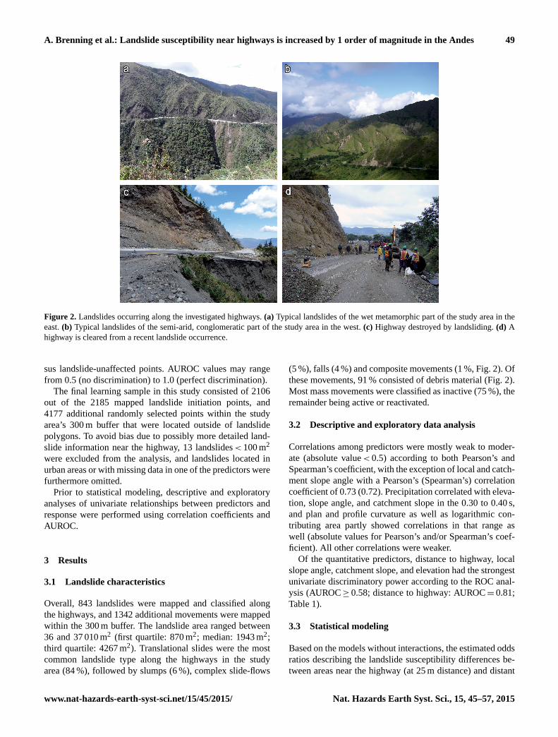
Figure 2. Landslides occurring along the investigated highways. (a) Typical landslides of the wet metamorphic part of the study area in the
east. (b) Typical landslides of the semi-arid, conglomeratic part of the study area in the west. (c) Highway destroyed by landsliding. (d) A
highway is cleared from a recent landslide occurrence.
sus landslide-unaffected points. AUROC values may range
from 0.5 (no discrimination) to 1.0 (perfect discrimination).
The final learning sample in this study consisted of 2106
out of the 2185 mapped landslide initiation points, and
4177 additional randomly selected points within the study
area’s 300 m buffer that were located outside of landslide
polygons. To avoid bias due to possibly more detailed land-
slide information near the highway, 13 landslides< 100 m2
were excluded from the analysis, and landslides located in
urban areas or with missing data in one of the predictors were
furthermore omitted.
Prior to statistical modeling, descriptive and exploratory
analyses of univariate relationships between predictors and
response were performed using correlation coefficients and
AUROC.
3 Results
3.1 Landslide characteristics
Overall, 843 landslides were mapped and classified along
the highways, and 1342 additional movements were mapped
within the 300 m buffer. The landslide area ranged between
36 and 37 010 m2 (first quartile: 870 m2; median: 1943 m2;
third quartile: 4267 m2). Translational slides were the most
common landslide type along the highways in the study
area (84 %), followed by slumps (6 %), complex slide-flows
(5 %), falls (4 %) and composite movements (1 %, Fig. 2). Of
these movements, 91 % consisted of debris material (Fig. 2).
Most mass movements were classified as inactive (75 %), the
remainder being active or reactivated.
3.2 Descriptive and exploratory data analysis
Correlations among predictors were mostly weak to moder-
ate (absolute value< 0.5) according to both Pearson’s and
Spearman’s coefficient, with the exception of local and catch-
ment slope angle with a Pearson’s (Spearman’s) correlation
coefficient of 0.73 (0.72). Precipitation correlated with eleva-
tion, slope angle, and catchment slope in the 0.30 to 0.40 s,
and plan and profile curvature as well as logarithmic con-
tributing area partly showed correlations in that range as
well (absolute values for Pearson’s and/or Spearman’s coef-
ficient). All other correlations were weaker.
Of the quantitative predictors, distance to highway, local
slope angle, catchment slope, and elevation had the strongest
univariate discriminatory power according to the ROC anal-
ysis (AUROC≥ 0.58; distance to highway: AUROC= 0.81;
Table 1).
3.3 Statistical modeling
Based on the models without interactions, the estimated odds
ratios describing the landslide susceptibility differences be-
tween areas near the highway (at 25 m distance) and distant
www.nat-hazards-earth-syst-sci.net/15/45/2015/ Nat. Hazards Earth Syst. Sci., 15, 45–57, 2015

50 A. Brenning et al.: Landslide susceptibility near highways is increased by 1 order of magnitude in the Andes
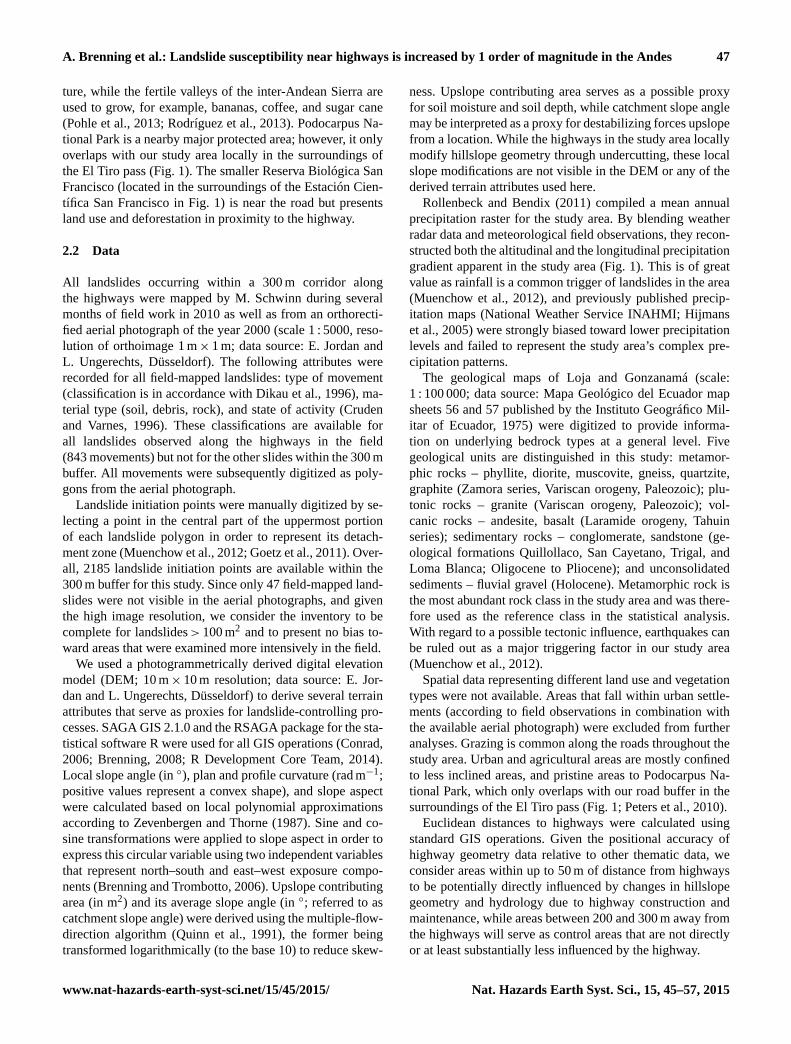
Figure 3. Transformation functions of the generalized additive model (GAM) without interaction term.
from it (at 200 m distance) while accounting for all other pre-
dictors were of the order of 18–21 according to all estimation
procedures, with lower 95 % confidence bounds> 13 (Ta-
ble 2). The GLM’s OR estimate was sensitive to the choice
of a distance value for the “distant from highway” category
because its assumed linear relationship tends to extend the
strong decrease in odds between 0 and 150–200 m distance
toward greater distances. Parametrically derived confidence
intervals from the GLM were substantially narrower than
spatial bootstrap confidence intervals (interval width 6.5 ver-
sus 12.9).
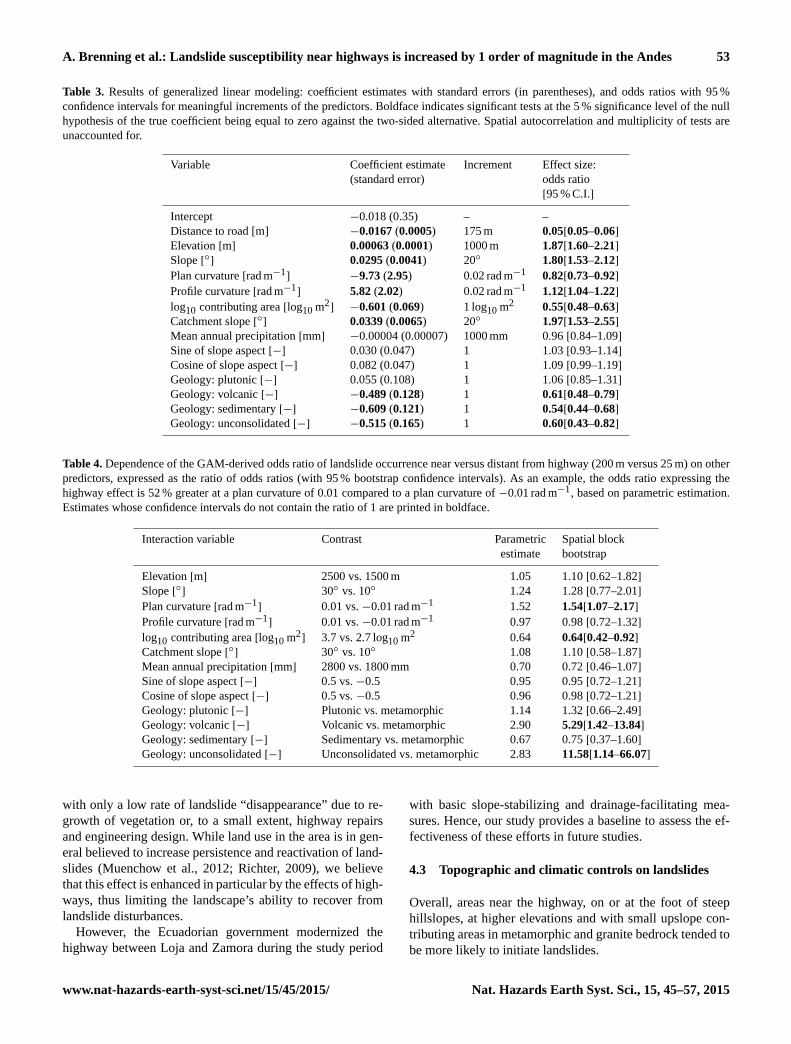
Estimated GLM coefficients and effect sizes for “meaning-
ful” increments indicate a predominance of distance to high-
way over other predictors (Table 3). Elevation, topographic
attributes (except slope aspect), and geology were additional
important predictors, each with an odds ratio of the order of 2
for meaningful increments in the predictor’s values. In con-
trast, mean annual precipitation was unrelated to landslide
initiation. The fitted GAM displayed nonlinear relationships,
especially for distance to highway and slope angle (Fig. 3).
Susceptibility to landslide initiation decreased steadily over
the first ∼ 150 m of distance to highway, where it started to
level off.
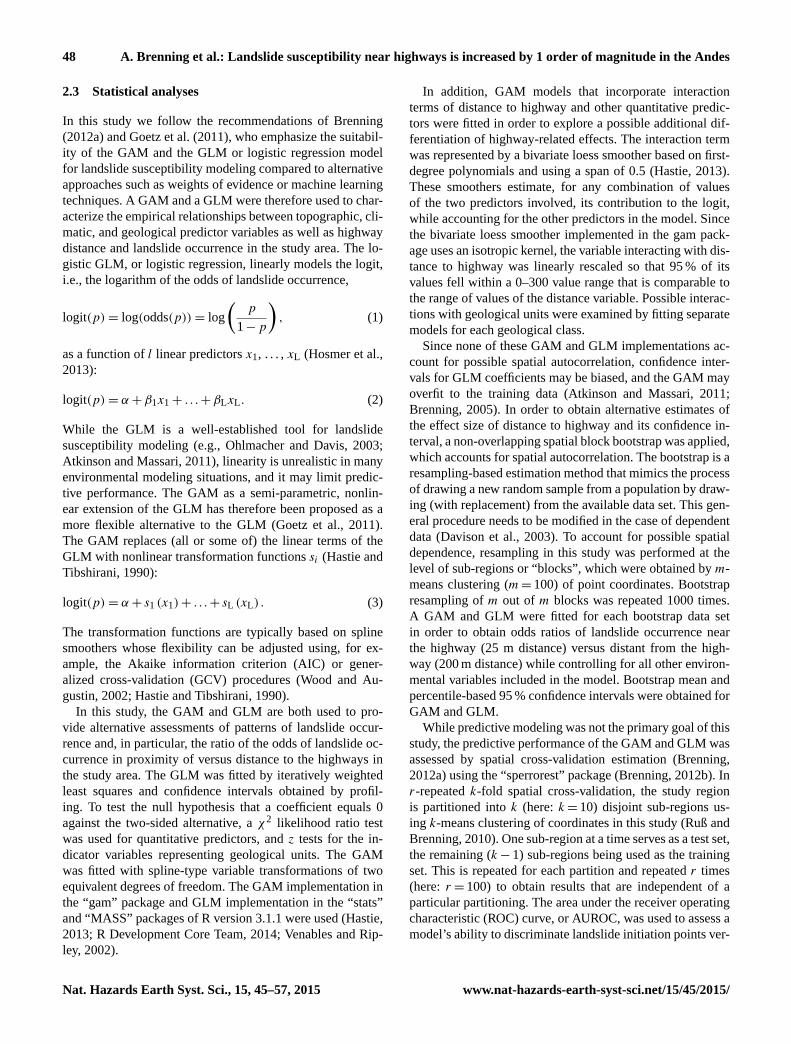
The explored nonlinear interaction terms of distance to
highway with each of the other quantitative predictors sug-
gest that highway-related effects on landslide initiation vary
by less than a factor of 2 depending on the values of in-
teracting variables, according to both bootstrap and para-
metric estimates (Table 4). However, with the exception of
the interaction with plan curvature and upslope contribut-
ing area, variations of this magnitude can be explained by
random sampling variability alone. According to these re-
sults, the highway-related odds ratio is 54 % greater on di-
vergent slopes (positive plan curvature) than on convergent
slopes (Fig. 4), and 56 % greater where the upslope con-
tributing area is 500 m2 compared to 5000 m2. Differences
in highway-related effects between the geological units seem
to be more pronounced. However, these are also subject to
Nat. Hazards Earth Syst. Sci., 15, 45–57, 2015 www.nat-hazards-earth-syst-sci.net/15/45/2015/

A. Brenning et al.: Landslide susceptibility near highways is increased by 1 order of magnitude in the Andes 51
Table 1. Descriptive statistics of the data set used for statistical modeling.
Non-landslides Landslides AUROC
median median
(1st/3rd quartile) (1st/3rd quartile)
Distance to road [m] 140 (70/215) 25 (10/55) 0.81
Elevation [m] 2211 (1672/2496) 2354 (1825/2561) 0.58
Slope [◦] 23.0 (14.1/31.6) 30.0 (20.4/37.8) 0.64
Plan curvature [rad m−1] 0.000 (−0.005/0.007) 0.001 (−0.006/0.009) 0.52
Profile curvature [rad m−1] 0.000 (−0.007/0.006) 0.000 (−0.009/0.010) 0.52
Log10 contributing area [log10 m2] 3.1 (2.8/3.6) 3.0 (2.7/3.4) 0.56
Catchment slope [◦] 23.8 (17.9/29.3) 27.6 (22.2/32.7) 0.63
Sine of slope aspect [−] 0.20 (−0.59/0.84) 0.24 (−0.45/0.78) 0.51
Cosine of slope aspect [−] −0.01 (−0.68/0.68) 0.18 (−0.68/0.83) 0.53
Mean annual precipitation [mm] 2286 (1797/2733) 2332 (1797/2829) 0.53
Geology:
– Metamorphic 2274∗ 1409∗ –
– Plutonic 542 301
– Volcanic 343 157
– Sedimentary 673 168
– Unconsolidated 345 71
∗ sample counts
Table 2. Estimated odds ratios and their 95 % confidence intervals
for landslide occurrence distant from roads (200 m distance) versus
near the road (25 m distance) using the GAM and GLM. Estimation
based on the spatial block bootstrap and the standard parametric
approach.
Parametric Spatial block
estimation bootstrap
GAM 21.2∗ 19.6 [15.5–25.3]
GLM 18.4 [15.5–22.0] 18.9 [13.7–26.6]
∗ Parametric confidence intervals not available for the GAM.
greater uncertainty due to smaller subsamples and substan-
tial differences between bootstrap and parametric estimates.
Highway-related effects appear to be enhanced – and possi-
bly strongly so – in units 13 (Laramide andesite and basalt)
and 2 (Holocene fluvial gravel; Table 4).
The GAM-derived landslide susceptibility map in Fig. 5
highlights highway-related effects as well as local topo-
graphic modifications. The overall ability of the GAM and
GLM models to discriminate landslide initiation points ver-
sus stable locations is very good, with slightly improved
performances for the GAM (spatial cross-validation AU-
ROC 0.853; training set estimation: 0.866) compared to the
GLM (0.838/0.850). Training set estimates of AUROC are
slightly higher and therefore overoptimistic.
4 Discussion
4.1 Highway-related landslide hazards: empirical
findings
Our results indicate that landslide hazard was strongly in-
creased in close proximity to mountain highways in the An-
des of southern Ecuador compared to control areas at∼ 150–
300 m distance. The estimated odds ratio of landslide initia-
tion at 25 m distance versus 200 m distance was 18–21, with
lower 95 % confidence bounds> 13 in all analyses while ac-
counting for several topographic, climatic, and geological
confounders, but without interaction terms. Spatial bootstrap
estimation using the GAM supports the higher odds ratio es-
timate of 21.2 (95 % confidence interval: 15.5–25.3). This
odds ratio furthermore appears to vary to some extent de-
pending on plan curvature, upslope contributing area, and
geological unit, according to the analysis of interactions.
The estimated increase in landslide hazard near roads – in-
terurban highways in a developing country – is comparable to
increases encountered in other studies in proximity to unim-
proved roads, largely harvest roads. Sidle and Ochiai (2006)
indicate an increase by 1 order of magnitude compared to
clearcuts and 2 orders of magnitude compared to undisturbed
forest land in humid temperate climates, while landslide oc-
currence near forest roads in the Oregon Coast Range was
only doubled to tripled (Miller and Burnett, 2007). In the
humid tropical mountains of Puerto Rico, landslide erosion
along highways was 5 times higher in proximity (< 85 m)
to highways compared to adjacent forests (Sidle and Ochiai,
2006; Larsen and Parks, 1997). In the humid Andes of south-
www.nat-hazards-earth-syst-sci.net/15/45/2015/ Nat. Hazards Earth Syst. Sci., 15, 45–57, 2015

52 A. Brenning et al.: Landslide susceptibility near highways is increased by 1 order of magnitude in the Andes
Figure 4. Odds ratio of landslide initiation versus distance to road
based on (a) GAMs with interaction between distance and plan cur-
vature, and (b) separate GAMs for the different geological units.
Odds ratios are relative to the odds at a distance of 200 m (black dot)
at a straight plan curvature and in geological unit 11, respectively.
Grey dashed line: GAM without interaction term for comparison.
ern Ecuador, in a smaller area that overlaps with a highway
segment of the present study, landslide-related material mo-
bilization rates in a human-influenced area were, on average,
more than twice as high as in the surrounding natural trop-
ical mountain rainforests (Muenchow et al., 2012). In addi-
tion, the mobilization rate in close proximity to the highway
was increased by a factor of 2–4 compared to the human-
influenced background, which was partly related to increased
landslide frequency but also larger (and deeper) landslides
near the highway (Muenchow et al., 2012). The present study
shows that comparable increases in landslide hazard in prox-
imity to an interurban highway in a developing country by at
least 1 order of magnitude can, overall, be generalized across
a variety of environmental conditions found in this study re-
gion. This contrasts with results from the Indian Himalayas,
where areas near a highway only showed an increase in land-
slide hazard of the order of 50 % (Das et al., 2012).
Our results furthermore suggest that highway effects ex-
tend up to a distance of ∼ 150 m from the highway. This dis-
tance seems to be greater than the influence distance of up to
100 m observed by Larsen and Parks (1997) for Puerto Rican
highways, or of up to 50 m for logging roads on Vancouver
Island (Goetz et al., 2014). Our observations suggest that this
Figure 5. Landslide susceptibility index maps for a portion of the
study area (Fig. 1) based on the GAM.
may be due to the growth of landslides as a consequence of
successive reactivation.
Nevertheless, the present findings also have limitations re-
lated to study design and data quality. In this study, we can
be confident that landslide inventory quality was constant
throughout the 300 m corridor along the highway regardless
of field-assisted mapping or mapping based on 1 m× 1 m
aerial photographs. A bias in estimates of highway effects
would have been introduced if landslide mapping based on
aerial photographs had been less complete than field-based
mapping, which was focused on areas near the road. This was
not the case in our study. Direct causal mechanisms related
to highway construction and design may furthermore be con-
founded, to a limited extent, with a possibly higher intensity
of land use in close proximity to the highways. However, we
do not have direct evidence that any of these possible effects
are of substantial concern in this particular study region.
4.2 Highway-related landslide hazards: causal
mechanisms
While a variety of causal mechanism can contribute to an
increase in landslide incidence near highways, it has been
pointed out that highways in developing countries are partic-
ularly vulnerable due to often poor engineering design (Sidle
and Ochiai, 2006; Sidle et al., 2006).
In addition to the effects that highways have by under-
cutting or mechanically overloading hillslopes, the lack of
a drainage system in this study area has to be pointed out as
an additional feature that may reduce slope stability.
Slides associated with the highway in our study area are
also more susceptible to reactivation than slides located at
greater distance from the road (Muenchow et al., 2012).
Since the highways of the study area have existed in their
present design since at least the beginning of the 1960s (Beck
et al., 2008), we suggest that the landslide population in prox-
imity to the highway has been growing for half a century,
Nat. Hazards Earth Syst. Sci., 15, 45–57, 2015 www.nat-hazards-earth-syst-sci.net/15/45/2015/
A. Brenning et al.: Landslide susceptibility near highways is increased by 1 order of magnitude in the Andes 53
Table 3. Results of generalized linear modeling: coefficient estimates with standard errors (in parentheses), and odds ratios with 95 %
confidence intervals for meaningful increments of the predictors. Boldface indicates significant tests at the 5 % significance level of the null
hypothesis of the true coefficient being equal to zero against the two-sided alternative. Spatial autocorrelation and multiplicity of tests are
unaccounted for.
Variable Coefficient estimate Increment Effect size:
(standard error) odds ratio
[95 % C.I.]
Intercept −0.018 (0.35) – –
Distance to road [m] −0.0167 (0.0005) 175 m 0.05[0.05–0.06]
Elevation [m] 0.00063 (0.0001) 1000 m 1.87[1.60–2.21]
Slope [◦] 0.0295 (0.0041) 20◦ 1.80[1.53–2.12]
Plan curvature [rad m−1] −9.73 (2.95) 0.02 rad m−1 0.82[0.73–0.92]
Profile curvature [rad m−1] 5.82 (2.02) 0.02 rad m−1 1.12[1.04–1.22]
log10 contributing area [log10 m2] −0.601 (0.069) 1 log10 m2 0.55[0.48–0.63]
Catchment slope [◦] 0.0339 (0.0065) 20◦ 1.97[1.53–2.55]
Mean annual precipitation [mm] −0.00004 (0.00007) 1000 mm 0.96 [0.84–1.09]
Sine of slope aspect [−] 0.030 (0.047) 1 1.03 [0.93–1.14]
Cosine of slope aspect [−] 0.082 (0.047) 1 1.09 [0.99–1.19]
Geology: plutonic [−] 0.055 (0.108) 1 1.06 [0.85–1.31]
Geology: volcanic [−] −0.489 (0.128) 1 0.61[0.48–0.79]
Geology: sedimentary [−] −0.609 (0.121) 1 0.54[0.44–0.68]
Geology: unconsolidated [−] −0.515 (0.165) 1 0.60[0.43–0.82]
Table 4. Dependence of the GAM-derived odds ratio of landslide occurrence near versus distant from highway (200 m versus 25 m) on other
predictors, expressed as the ratio of odds ratios (with 95 % bootstrap confidence intervals). As an example, the odds ratio expressing the
highway effect is 52 % greater at a plan curvature of 0.01 compared to a plan curvature of −0.01 rad m−1, based on parametric estimation.
Estimates whose confidence intervals do not contain the ratio of 1 are printed in boldface.
Interaction variable Contrast Parametric Spatial block
estimate bootstrap
Elevation [m] 2500 vs. 1500 m 1.05 1.10 [0.62–1.82]
Slope [◦] 30◦ vs. 10◦ 1.24 1.28 [0.77–2.01]
Plan curvature [rad m−1] 0.01 vs. −0.01 rad m−1 1.52 1.54[1.07–2.17]
Profile curvature [rad m−1] 0.01 vs. −0.01 rad m−1 0.97 0.98 [0.72–1.32]
log10 contributing area [log10 m2] 3.7 vs. 2.7 log10 m2 0.64 0.64[0.42–0.92]
Catchment slope [◦] 30◦ vs. 10◦ 1.08 1.10 [0.58–1.87]
Mean annual precipitation [mm] 2800 vs. 1800 mm 0.70 0.72 [0.46–1.07]
Sine of slope aspect [−] 0.5 vs. −0.5 0.95 0.95 [0.72–1.21]
Cosine of slope aspect [−] 0.5 vs. −0.5 0.96 0.98 [0.72–1.21]
Geology: plutonic [−] Plutonic vs. metamorphic 1.14 1.32 [0.66–2.49]
Geology: volcanic [−] Volcanic vs. metamorphic 2.90 5.29[1.42–13.84]
Geology: sedimentary [−] Sedimentary vs. metamorphic 0.67 0.75 [0.37–1.60]
Geology: unconsolidated [−] Unconsolidated vs. metamorphic 2.83 11.58[1.14–66.07]
with only a low rate of landslide “disappearance” due to re-
growth of vegetation or, to a small extent, highway repairs
and engineering design. While land use in the area is in gen-
eral believed to increase persistence and reactivation of land-
slides (Muenchow et al., 2012; Richter, 2009), we believe
that this effect is enhanced in particular by the effects of high-
ways, thus limiting the landscape’s ability to recover from
landslide disturbances.
However, the Ecuadorian government modernized the
highway between Loja and Zamora during the study period
with basic slope-stabilizing and drainage-facilitating mea-
sures. Hence, our study provides a baseline to assess the ef-
fectiveness of these efforts in future studies.
4.3 Topographic and climatic controls on landslides
Overall, areas near the highway, on or at the foot of steep
hillslopes, at higher elevations and with small upslope con-
tributing areas in metamorphic and granite bedrock tended to
be more likely to initiate landslides.
www.nat-hazards-earth-syst-sci.net/15/45/2015/ Nat. Hazards Earth Syst. Sci., 15, 45–57, 2015
54 A. Brenning et al.: Landslide susceptibility near highways is increased by 1 order of magnitude in the Andes
Generally, differences among geological units exerted
only a relatively minor influence on landslide occurrence.
The slightly increased susceptibility in the metamorphic ar-
eas might be due to interspersing layers of highly weath-
ered phyllites and clay schists and a slight dip to the east
(Beck et al., 2008; Litherland et al., 1994). Overall, how-
ever, geomechanical differences between the general geo-
logical units used here appear to result in very minor vari-
ations in landslide susceptibility relative to the overwhelm-
ing highway effect. Nevertheless, highway-related effects are
likely enhanced in the geological units that are comprised
of volcanic rocks (Laramide andesite and basalt) and uncon-
solidated material (Holocene fluvial gravel). The geological
units furthermore consist of a variety of subunits, which may
obscure more prominent differences among geomechanically
more distinct subunits.
As expected for this area (Muenchow et al., 2012; Vorpahl
et al., 2012, 2013; Richter, 2009), slope steepness was an
important predictor of slope failure in terms of both local
slope angle and mean slope angle of the upslope contributing
area. Steep upslope contributing areas may serve as a proxy
for mechanical destabilization due to overloading.
Landslides furthermore tended to occur in locations with
smaller upslope contributing areas, i.e., near the local ridges.
This may seem counterintuitive as hillslope hydrology would
suggest that soil saturation is more likely to occur at locations
with larger contributing areas (Montgomery and Dietrich,
1994). However, while landslide initiation points are mapped
in the uppermost portion of the observed landslide area, ad-
ditional locations further downslope from the observed ini-
tiation points may also be unstable but are not mapped as
initiation points. This may result in the observed tendency of
mapped landslide initiation points to exhibit smaller upslope
contributing areas. In addition, larger upslope contributing
areas> 1 ha often correspond to drainage channels, which
are less steep and are often associated with surface runoff.
Numerous studies have shown that precipitation (Guzzetti
et al., 2008), especially if exceeding certain thresholds
(Caine, 1980; Giannecchini, 2006; Jibson, 1989), is one of
the most common triggers of (shallow) landslides (Aleotti,
2004) in mountainous regions, including our study region
(Muenchow et al., 2012; Vorpahl et al., 2012). Accordingly,
the negligible influence of (mean annual) precipitation in our
landslide susceptibility models may come as a surprise, es-
pecially when considering that the majority of the mapped
landslides are shallow debris slides. However, despite the
enormous differences in mean annual precipitation across the
study area, this variable may not be a good proxy for the
frequency of potentially landslide-triggering extreme rainfall
events in this area since critical rainfall intensities occur even
in the drier parts up to once per year on average (Muenchow
et al., 2012). Mean annual precipitation may also be a proxy
for land use differences. In addition, the persistence of land-
slide scars in the landscape may blur the expected rainfall
effect since landslides in the drier area are thought to persist
longer than landslides in the more humid part, where faster
regrowth of vegetation occurs (Peters et al., 2010). Thus,
multi-temporal landslide inventories would be needed to ac-
count for these differences in persistence in the landscape.
Elevation was another important predictor, which may be a
proxy for altitudinal differences in vegetation and land use as
well as local trends in landslide-triggering rainfall events that
are not captured by the available precipitation data. However,
given the substantial shift in climatic regimes in the west–
east direction in our study area and the lack of detailed land
use and land cover data, separating these effects and their
possible interactions should be the object of future studies.
4.4 Statistical methodology
The approach of modeling landslide–environment relation-
ships using the GAM and estimating odds ratios using a spa-
tial bootstrap was preferred in this study over the use of the
simpler GLM, as well as over attempting to model spatial
autocorrelation in a parametric framework.
The GAM is able to account for nonlinear relationships
(e.g., Goetz et al., 2011), which may or may not be strong, but
which cannot be ruled out in advance in a heterogeneous en-
vironment. While the performance difference between GLM
and GAM appears to be small, the inability of the GLM to
represent nonlinear relationships may produce an important
local bias in predicted landslide susceptibility, for example
in close proximity to the road, where the distance decay is
greatest. The estimation of odds ratios with the GLM for
the nonlinear distance variable is furthermore more sensi-
tive to the choice of the control distance that is thought of
as being unaffected by the highway, e.g., 200 or 250 m dis-
tance. A logarithmic transformation of distance to highway
as performed by Muenchow et al. (2012), by contrast, may
obscure the transition between highway-influenced and un-
affected distances. The comfortable size of the present data
set also allowed us to fit this more flexible model type with-
out overfitting to the training data.
Spatial autocorrelation may violate the independence as-
sumption underlying GLMs and GAMs, which in turn would
invalidate statistical hypothesis tests and render confidence
intervals for model coefficients and derived odds ratios in-
valid (Dormann et al., 2007). Extensions of the GLM (Ven-
ables and Ripley, 2002) and GAM (Wood, 2006) that incor-
porate parametric representations of residual spatial autocor-
relation are, especially for large data sets, often computation-
ally very intensive, and results can depend on the particular
implementation as well as the choice of a specific approxima-
tion of the model’s likelihood function (Venables and Ripley,
2002). The spatial bootstrap, although itself subject to the
choice of a suitable spatial block size, was therefore selected
in this study as a nonparametric alternative that is transpar-
ent and can be combined with complex models such as the
GAM. The comparison of bootstrap and ML-based confi-
dence limits for the odds ratio of distance to highway in
Nat. Hazards Earth Syst. Sci., 15, 45–57, 2015 www.nat-hazards-earth-syst-sci.net/15/45/2015/

A. Brenning et al.: Landslide susceptibility near highways is increased by 1 order of magnitude in the Andes 55
the GLM suggests that a non-spatial parametric estimation
would substantially underestimate the margin of error (inter-
val width 6.5 versus 12.9; Table 2).
5 Conclusions
Landslide susceptibility was found to be increased by more
than 1 order of magnitude in close vicinity to paved interur-
ban highways in the Andes of southern Ecuador. This over-
whelming influence of highways, which fades at about 150 m
distance, persists along a strong climatic gradient as well as
throughout areas with metamorphic as well as sedimentary
rock types. Topographic factors are of secondary importance
(odds ratios< 2) in modifying highway effects, while road
influence appears to be enhanced in geological units with
Holocene gravel and Laramide andesite/basalt. Further re-
search is needed to determine the role that land use may play
in contributing to or modifying road-related effects.
Model predictions identifying locations that are most sus-
ceptible to landsliding can be instrumental in planning mit-
igation measures in a cost-effective way. The present study
may furthermore serve as a baseline for assessing the effec-
tiveness of resulting improvements to engineering design.
Acknowledgements. We are greatly indebted to the Zantner-Busch-
Stiftung for a travel grant awarded to M. Schwinn, and to the
German Research Foundation (DFG) for granting access to the
facilities of the ECSF research station. We furthermore acknowl-
edge support provided by the Department of Foreign Affairs, Trade
and Development Canada to A. P. Ruiz and a NSERC Discovery
Grant awarded to A. Brenning. We also thank Dr. E. Jordan and
L. Ungerechts for providing remote sensing data and M. Richter
(Erlangen) for his support. We are also grateful to A. Pradhan
and the anonymous reviewer for their comments, which greatly
improved our manuscript. Finally, we would like to warmly thank
Michael Krautblatter (Technische Universität München) for fruitful
and very helpful discussions on landslide properties.
Edited by: P. Tarolli
Reviewed by: A. Pradhan and another anonymous referee
References
Aleotti, P.: A warning system for rainfall-induced shallow failures,
Eng. Geol., 73, 247–265, 2004.
Atkinson, P. M. and Massari, R.: Autologistic modelling of suscep-
tibility to landsliding in the Central Apennines, Italy, Geomor-
phology, 130, 55–64, 2011.
Beck, E., Makeschin, F., Haubrich, F., Richter, M., Bendix, J., and
Valerezo, C.: The ecosystem (Reserva Biológica San Francisco),
in: Gradients in a Tropical Mountain Ecosystem of Ecuador,
edited by: Beck, E., Bendix, J., Kottke, I., Makeschin, F., and
Mosandl, R., Springer-11642/Dig. Serial 198, Springer, Berlin,
Heidelberg, 1–14, 2008.
Brenning, A.: Spatial prediction models for landslide hazards: re-
view, comparison and evaluation, Nat. Hazards Earth Syst. Sci.,
5, 853–862, doi:10.5194/nhess-5-853-2005, 2005.
Brenning, A.: Statistical geocomputing combining R and SAGA:
The example of landslide susceptibility analysis with generalized
additive models, SAGA – Seconds Out., Hamburger Beiträge
zur Physischen Geographie und Landschaftsökologie, 19, 23–32,
2008.
Brenning, A.: Improved spatial analysis and prediction of landslide
susceptibility: Practical recommendations, in: Landslides and
Engineered Slopes: Protecting Society through Improved Under-
standing, Proceedings of the 11th International and 2nd North
American Symposium on Landslides and Engineered Slopes,
Banff, Canada, 3–8 June 2012, edited by: Eberhardt, E., Froese,
C., Turner, A. K., and Leroueil, S., CRC Press, Balkema, Leiden,
789–794, 2012a.
Brenning, A.: Spatial cross-validation and bootstrap for the as-
sessment of prediction rules in remote sensing: The R pack-
age sperrorest, IEEE Int. Symp. Geosci. Remote S., 5372–5375,
doi:10.1109/IGARSS.2012.6352393, 2012b.
Brenning, A. and Trombotto, D.: Logistic regression modeling of
rock glacier and glacier distribution: Topographic and climatic
controls in the semi-arid Andes, Geomorphology, 81, 141–154,
2006.
Caine, N.: The rainfall intensity: duration control of shallow land-
slides and debris flows, Geogr. Ann. A, 62, 23–27, 1980.
Cendrero, A., Remondo, J., and Bonachea, J.: Sensitivity of land-
scape evolution and geomorphic processes to direct and indirect
human influence, Geogr. Fis. Din. Quat., 29, 125–138, 2006.
Conrad, O.: SAGA – program structure and current state of imple-
mentation, in: SAGA – Analysis and Modelling Applications,
edited by: Böhner, J., McCloy, K. R., and Strobl, J., Göttinger
Geographische Abhandlungen, Göttingen, 39-52, 2006.
Crozier, M. J.: Deciphering the effect of climate change on landslide
activity: A review, Geomorphology, 124, 260–267, 2010.
Cruden, D. M. and Varnes, D. J.: Landslide types and processes, in:
Landslides: Investigation and Mitigation, edited by: Turner, A.
K. and Schuster, R. L., National Academic Press, Washington,
D.C., 36–75, 1996.
Das, I., Stein, A., Kerle, N., and Dadhwal, V. K.: Landslide sus-
ceptibility mapping along road corridors in the Indian Himalayas
using Bayesian logistic regression models, Geomorphology, 179,
116–125, 2012.
Davison, A. C., Hinkley, D. V., and Young, G. A.: Recent develop-
ments in bootstrap methodology, Stat. Sci., 18, 141–157, 2003.
Dikau, R., Brunsden, D., Schrott, L., and Ibsen, M. L. (Eds.): Land-
slide Recognition: Identification, Movement and Causes, Wiley,
Chichester, 1996.
Dormann, C. F., McPherson, J. M., Araujo, M. B., Bivand, R., Bol-
liger, J., Carl, G., Davies, R. G., Hirzel, A., Jetz, W., Kissling, W.
D., Kuehn, I., Ohlemueller, R., Peres-Neto, P. R., Reineking, B.,
Schroeder, B., Schurr, F. M., and Wilson, R.: Methods to account
for spatial autocorrelation in the analysis of species distributional
data: a review, Ecography, 30, 609–628, 2007.
Fassin, D. and Vasquez, P.: Humanitarian exception as the rule: The
political theology of the 1999 Tragedia in Venezuela, Am. Eth-
nol., 32, 389–405, 2005.
www.nat-hazards-earth-syst-sci.net/15/45/2015/ Nat. Hazards Earth Syst. Sci., 15, 45–57, 2015

56 A. Brenning et al.: Landslide susceptibility near highways is increased by 1 order of magnitude in the Andes
Giannecchini, R.: Relationship between rainfall and shallow land-
slides in the southern Apuan Alps (Italy), Nat. Hazards Earth
Syst. Sci., 6, 357–364, doi:10.5194/nhess-6-357-2006, 2006.
Glade, T.: Landslide occurrence as a response to land use change:
a review of evidence from New Zealand, Catena, 51, 297–314,
2003.
Goetz, J. N., Guthrie, R. H., and Brenning, A.: Integrating physical
and empirical landslide susceptibility models using generalized
additive models, Geomorphology, 129, 376–386, 2011.
Goetz, J. N., Guthrie, R. H., and Brenning, A.: Forest harvesting
is associated with increased landslide activity during an extreme
rainstorm on Vancouver Island, Canada, Nat. Hazards Earth Syst.
Sci. Discuss., 2, 5525–5574, doi:10.5194/nhessd-2-5525-2014,
2014.
Guzzetti, F., Peruccacci, S., Rossi, M., and Stark, C. P.: The rainfall
intensity-duration control of shallow landslides and debris flows:
an update, Landslides, 5, 3–17, 2008.
Hastie, T.: gam: Generalized Additive Models, R package ver-
sion 1.08, http://CRAN.R-project.org/package=gam, last access:
29 August 2013.
Hastie, T. and Tibshirani, R.: Generalized additive models, Chap-
man and Hall, London, 1990.
Hijmans, R. J., Cameron, S. E., Parra, J. L., Jones, P. G., and Jarvis,
A.: Very high resolution interpolated climate surfaces for global
land areas, Int. J. Climatol., 25, 1965–1978, 2005.
Hosmer, D. W., Lemeshow, S., and Sturdivant, R.: Applied logis-
tic regression, 3rd Edn., Wiley Series in Probability and Statis-
tics 398, John Wiley & Sons, Inc., New York, 528 pp., 2013.
Jibson, R. W.: Debris flows in Southern Puerto Rico, in: Landslide
processes of the eastern United States and Puerto Rico, edited by:
Schultz, A. P. and Jibson, R. W., Geological Society of America
Special Paper 236, Geological Society of America, Boulder, CO,
29–55, 1989.
Larsen, M. C. and Parks, J. E.: How wide is a road? The association
of roads and mass-wasting in a forested montane environment,
Earth Surf. Proc. Land., 22, 835–848, 1997.
Litherland, M., Aspden, J. A., and Jemielita, R. A.: The meta-
morphic belts of Ecuador, British Geological Survey, Bath, UK,
1994.
Miller, D. J. and Burnett, K. M.: Effects of forest cover, topog-
raphy, and sampling extent on the measured density of shal-
low, translational landslides, Water Resour. Res., 43, W03433,
doi:10.1029/2005WR004807, 2007.
Molina, A., Govers, G., Poesen, J., Van Hemelryck, H., De Bievre,
B., and Vanacker, V.: Environmental factors controlling spatial
variation in sediment yield in a central Andean mountain area,
Geomorphology, 98, 176–186, 2008.
Montgomery, D. R. and Dietrich, W. E.: A physically-based model
for the topographic control on shallow landsliding, Water Resour.
Res., 30, 1153–1171, 1994.
Muenchow, J., Brenning, A., and Richter, M.: Geomorphic process
rates of landslides along a humidity gradient in the tropical An-
des, Geomorphology, 139, 271–284, 2012.
Ohlmacher, G. C. and Davis, J. C.: Using multiple logistic regres-
sion and GIS technology to predict landslide hazard in northeast
Kansas, USA, Eng. Geol., 69, 331–343, 2003.
Peters, T., Diertl, K.-H., Gawlik, J., Rankl, M., and Richter, M.: Vas-
cular plant diversity in natural and anthropogenic ecosystems in
the Andes of Southern Ecuador: Studies from the Rio San Fran-
cisco valley, Mt. Res. Dev., 30, 344–352, 2010.
Pohle, P., Gerique, A., López, M. F., and Spohner, R.: Current
provisioning ecosystem services for the local population: Land-
scape transformation, food production, and plant use, in: Ecosys-
tem services, biodiversity and environmental change in a tropi-
cal mountain ecosystem of South Ecuador, edited by: Beck, E.,
Bräuning, A., Makeschin, F., Mosandl, R., Scheu, S., and Wilcke,
W., Ecological Studies, Springer, Berlin, Heidelberg, 2013.
Quinn, P., Beven, K., Chevallier, P., and Planchon, O.: The predic-
tion of hillslope flow paths for distributed hydrological modelling
using digital terrain models, Hydrol. Process., 5, 59–79, 1991.
R Development Core Team: R: A language and environment
for statistical computing: http://www.R-project.org/, last access:
6 September 2014.
Richter, M.: To what extent do natural disturbances contribute to
Andean plant diversity? A theoretical outline from the wettest
and driest parts of the tropical Andes, Adv. Geosci., 22, 95–105,
doi:10.5194/adgeo-22-95-2009, 2009.
Rodríguez, F., Bräuning, A., Gerique, A., Behling, H., and Vol-
land, F.: Current cultural services: Landscape history, in: Ecosys-
tem services, biodiversity and environmental change in a tropi-
cal mountain ecosystem of South Ecuador, edited by: Beck, E.,
Bräuning, A., Makeschin, F., Mosandl, R., Scheu, S., and Wilcke,
W., Ecological Studies, Springer, Berlin, Heidelberg, 2013.
Rollenbeck, R. and Bendix, J.: Rainfall distribution in the Andes
of southern Ecuador derived from blending weather radar data
and meteorological field observations, Atmos. Res., 99, 277–289,
2011.
Ruß, G. and Brenning, A.: Data mining in precision agriculture:
Management of spatial information, Lect. Notes Comput. Sc.,
6178, 350–359, 2010.
Sidle, R. C. and Ochiai, H.: Landslides: Processes, prediction, and
land use, Water Resources Monograph, AGU, Washington, D.C.,
2006.
Sidle, R. C., Ziegler, A. D., Negishi, J. N., Nik, A. R., Siew, R.,
and Turkelboom, F.: Erosion processes in steep terrain – Truths,
myths, and uncertainties related to forest management in South-
east Asia, Forest Ecol. Manage., 224, 199–225, 2006.
Vanacker, V., Molina, A., Govers, G., Poesen, J., and Deckers, J.:
Spatial variation of suspended sediment concentrations in a trop-
ical Andean river system: The Paute River, southern Ecuador,
Geomorphology, 87, 53–67, 2007.
Venables, W. N. and Ripley, B. D.: Modern applied statistics with
S, 4th Edn., Springer, New York, 497 pp., 2002.
Vorpahl, P., Elsenbeer, H., Marker, M., and Schroder, B.: How
can statistical models help to determine driving factors of land-
slides?, Ecol. Model., 239, 27–39, 2012.
Vorpahl, P., Dislich, C., Elsenbeer, H., Marker, M., and Schroder,
B.: Biotic controls on shallow translational landslides, Earth
Surf. Proc. Land., 38, 198–212, 2013.
Vranken, L., Van Turnhout, P., Van den Eeckhaut, M., Vandekerck-
hove, L., and Poesen, J.: Economic valuation of landslide damage
in hilly regions: A case study from Flanders, Belgium, Sci. Total
Environ., 447, 323–336, 2013.
Wood, S. N.: Generalized additive models: An introduction with
R, Texts in statistical science, Chapman & Hall/CRC Press, Boca
Raton, 391 pp., 2006.
Nat. Hazards Earth Syst. Sci., 15, 45–57, 2015 www.nat-hazards-earth-syst-sci.net/15/45/2015/

A. Brenning et al.: Landslide susceptibility near highways is increased by 1 order of magnitude in the Andes 57
Wood, S. N. and Augustin, N. H.: GAMs with integrated model
selection using penalized regression splines and applications to
environmental modelling, Ecol. Model., 157, 157–177, 2002.
Zevenbergen, L. W. and Thorne, C. R.: Quantitative analysis of land
surface topography, Earth Surf. Proc. Land., 12, 47–56, 1987.
www.nat-hazards-earth-syst-sci.net/15/45/2015/ Nat. Hazards Earth Syst. Sci., 15, 45–57, 2015