langscape magazine is a - · pdf filelangscape magazine is an extension of the voice of...
TRANSCRIPT


Langscape Magazine is a Terralingua Publication
Terralingua thanks the Reva and David Logan Foundation and Kalliopeia Foundation
for their generous support.
Editor: Luisa MaffiEditorial Assistant: Coreen Boucher
Web Developer: Phil ReesGraphic Design: Imagine That Graphics
Printing: Contour Grafix
Learn about Terralingua: www.terralingua.orgReceive Langscape Magazine by subscribing or
by purchasing single copies. Details at www.terralinguaubuntu.org
Learn about Langscape Magazine: www.terralinguaubuntu.org/langscape/home.htm
ISSN 2371-3291 (print) ISSN 2371-3305 (digital)
© Terralingua 2017
Langscape Magazine is an extension of the voice of Terralingua. It supports our mission by educating the minds and hearts
about the importance and value of biocultural diversity.
We aim to promote a paradigm shift by illustrating biocultural diversity through scientific and traditional knowledge, within an appealing
sensory context of articles, stories, and art.
ABOUT THE COVER PHOTOS
Front: “Grandmother, How Do I Learn?”
by Rose Thater Braan-Imai (Tuscarora), 2016
Back: One Square Meter photographed in nature by sunset in Extremadura, Spain.
Photo: Ana Trejo, 2017
People Mapping
Planning and resource management in urban and rural development often fail to
meaningfully engage local inhabitants. That misses two important aspects: firstly, a narrative of places already exists and is embedded in local knowledge; secondly, people are experts on their own living spaces. In addition, spaces and related processes are socially and continuously produced and reproduced by dwellers—shaped by their uses, values, attributions of meaning, and the relationships they interweave in daily life. This is why locals should always inform and contribute to decision-making that has to do with changes in space and resource use. To encourage their direct involvement, it then becomes crucial to provide interactive tools that facilitate fruitful dialogue and yield reliable, communicative, reusable “participatory products.”
People map-making includes these characteristics, while also visualizing the dynamics between the physical and the social in relation to space and environment. It is a dialogical method for representing reality, adaptable to different contexts, conditions, and purposes; it facilitates collaboration among stakeholders; and it offers proactive modalities of inclusion, giving equal status to participants.
In this creative map-making process people, often supported by facilitators, collectively represent the space they inhabit on maps or 3D relief models, according to their life experience, local know-how, and sense of belonging. Analyzing different contexts and problematic issues, they uncover existing resources and potentials and find opportunities
for intervention and improvement. Through map-making, they reveal the invisible structure of their living spaces; they coproduce cultural–spatial knowledge in relation to their territories. That knowledge is essential for creating a base on which to build and a point of reference for all stakeholders involved in rural or urban planning and resource management.
Maps make it possible to capture, record, and optimize data and information; they are flexible living tools that allow for continuous updating and support. They stimulate exploration and provide a
holistic and systemic perspective that is essential for better strategies. Maps are tools for understanding places, building awareness, and representing and voicing issues of any kind. They reveal the diversity of contexts, uncover internal dynamics and social relations including power relations, contribute to triggering spatial imaginaries, benefit dialogue for negotiation, and support design for action. They are never a final outcome but rather in constant flux, and the process of their creation is as important as the result they embody.
As a tool for information gathering, representation, and dissemination, however, mapping always raises issues of data access and ownership. That is
Barbara Dovarch
“Through map-making, people reveal the invisible structure of
their living spaces; they coproduce cultural–spatial knowledge in relation to their territories.”
Visualizing Sense of Place for Decision Making
60 | langscape magazIne summer 2017

People mapping is a creative and serious gameLocal knowledge and everyday experience are needed to playThere are no losers or winners, but roles and positionsThere are no leaders or teachers; everyone is both expert and learnerThere are no hierarchies, the main rule is respectEvery voice can be widely expressed and carefully heardWe want to map to be on the mapTo make visible our invisible slumsTo get recognition of our rights and dignify our livesTo lobby for land titles and consolidate our settlements...To have a visual reference when we communicate, claim, contest, negotiateWe want to map to protect our territoriesThrough identifying vulnerabilities and potentialsWe want to preserve our environmental resourcesCultural diversity and natural ecosystemsIndigenous structures and traditional customsWe want to map to save our planetTo provide holistic perspective for better strategiesTo understand the effects of our own actionsTo mitigate the impacts of disastrous events…Before Nature revolts one more time against irresponsible humansWe want to increase our awareness and resilienceWe want to map to keep our identityPrior to coping with any change or transformation in our neighborhoodWe want to make visible its apparently disordered logics
Telling the narrative that characterizes our physical and social contextsThe related sense of belonging and spontaneous place-making practicesWe want to map to move around freelyWe want to identify spaces where to invent our intrepid gamesWe want to give our hand to our classmates while going to school by ourselves in busy morningsWe want to design our routes, our road signs, and even our ban signsWe want to be free and safe in our own citiesWe want to map to reach communities and governmentsTo provide a catalyst for interaction and facilitate platforms of dialogueTo give space to conflict while finding possible solutions togetherTo discuss and make decisions jointlyTo easily represent our shared designs and plansWhile making maps, people deconstruct their reality to build a new inspiring knowledgeDiversity is revealed, aspirations are unleashed, and possible futures become visibleLooking from a bird’s-eye view, the bonds between natural features and cultural values emergeA jam mapping session evolves, where the instruments are people’s voices…And the musics are pieces of Earth.
Mappers’ voices are those of slum dwellers in India, Kenya, Brazil, and the Philippines; inhabitants of peri-urban areas in Vietnam; Indigenous groups in Easter Island; local communities and government officials in Samoa and Nauru; neighbors in Spain; children in India and Italy.
We Want to MapBarbara Dovarch
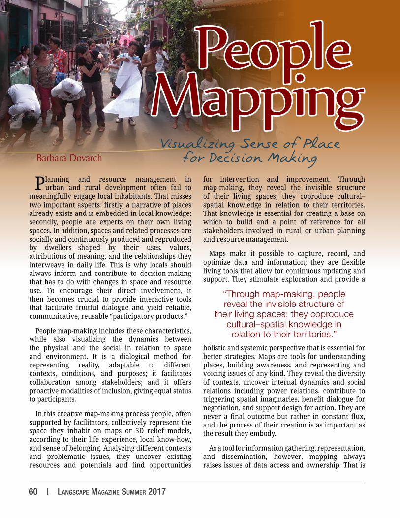
Previous page: Barangay Bagbaguin neighborhood, Valenzuela City, Great Manila. Community members and local university students measure the settlement’s roads.
Photo: Barbara Dovarch, 2013
Volume 6 Issue 1 | 61
why the practice of people mapping always needs to be consciously tied to specific circumstances and purposes and to be carried out in a deliberate manner by both facilitators and mappers.
Vietnam: Expertise Is with the Locals
“Now we have our maps… and therefore our plans for the future.”
—Vietnamese farmer
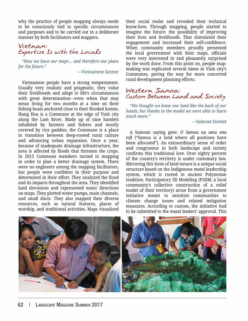
Vietnamese people have a strong temperament. Usually very realistic and pragmatic, they value their livelihoods and adapt to life’s circumstances with great determination—even when that may mean living for two months at a time on their fishing boats anchored close to their flooded homes. Hung Hoa is a Commune at the edge of Vinh city along the Lam River. Made up of nine hamlets inhabited by farmers and fishers and mostly covered by rice paddies, the Commune is a place in transition between deep-rooted rural culture and advancing urban expansion. Once a year, because of inadequate drainage infrastructure, the area is affected by floods that threaten the crops. In 2013 Commune members turned to mapping in order to plan a better drainage system. There were no engineers among the mapping facilitators, but people were confident in their purpose and determined in their effort. They analyzed the flood and its impacts throughout the area. They identified land elevations and represented water directions on maps. They plotted water pumps, main channels, and small ducts. They also mapped their diverse resources, such as natural features, places of worship, and traditional activities. Maps visualized
their social realm and revealed their technical know-how. Through mapping, people started to imagine the future: the possibility of improving their lives and livelihoods. That stimulated their engagement and increased their self-confidence. When community members proudly presented the local government with their maps, officials were very interested in and pleasantly surprised by the work done. From this point on, people map-making was replicated several times in Vinh city’s Communes, paving the way for more concerted rural development planning efforts.
Western Samoa: Custom Between Land and Society
“We thought we knew our land like the back of our hands, but thanks to the model we were able to learn much more.”
—Samoan farmer
A Samoan saying goes: O Samoa ua uma ona tofi (“Samoa is a land where all positions have been allocated”). An extraordinary sense of order and congruence in both landscape and society confirms this traditional lore. Over eighty percent of the country’s territory is under customary law. Mirroring this form of land tenure is a unique social structure based on the Indigenous matai leadership system, which is rooted in ancient Polynesian tradition. Participatory 3D Modeling (P3DM, a local community’s collective construction of a relief model of their territory) arose from a government initiative meant to sensitize communities to climate change issues and related mitigation measures. According to custom, the initiative had to be submitted to the matai leaders’ approval. This
62 | langscape magazIne summer 2017

was crucial, as land is in local people’s hands and resource management is strongly related to local culture. Strong social cohesion and the Samoan habit of working and making decisions collectively led to positive uptake. People realized that they play a central role in environmental protection and that changes in their behavior could increase their quality of life while reducing the risk of disasters, even when such changes might affect their cultural traditions. During mapping sessions in 2016, people discussed environmental issues and ways to manage them; youth learned Samoan proverbs from the matai; and elders identified toponyms, ancient place names related to Indigenous narratives and local history. Along with government officials, people organized to set up plant nurseries, implement agroforestry programs, and deal with waste disposal. P3DM provided an opportunity for communities and local authorities to come together, improve communication, and collaborate on sustainability issues, and has become an accepted practice in the country.
The Philippines: Planning is a Complex Process
“This is not a slum anymore, it is our neighborhood, and we want it to be properly represented on the map.”
—Barangay Bagbaguin dweller
People have lived in the Barangay Bagbaguin (Bagbaguin neighborhood) of Valenzuela City, in Greater Manila, for many years, building their own homes with bricks. In 2013, the community was in the process of collectively acquiring the land on which the settlement was built, but the government
requested that people first comply with the city’s official standards of safety and density. In particular, the only access road to the neighborhood had to be significantly widened. The purpose of people mapping here was to show the government what the community’s real conditions and needs were, as well as to demonstrate that planning is not just a matter of subdivision schemes based on technical standards, but rather a complex process that must adapt to different contexts and circumstances. Earlier on, the community had hired an engineer to map the settlement, but people quickly realized his map was inaccurate, as it did not respect the neighborhood’s architectural diversity in terms of its maze-like alleys and irregular housing typologies. That prompted 352 households to get together with great enthusiasm to create a proper map of their settlement. Once the map was finished, people went on to analyze the possibility of widening the road, respecting safety requirements while minimizing interventions on existing housing, and evaluated options for creating additional access points. The map was of great value when it came to devising alternative solutions and discussing proposals with Valenzuela City’s Mayor and municipal officers, as it allowed for constructive dialogue and supported fruitful negotiations between the two sides.
Nauru: Recovering Territorial Identity
“It is incredible: our island is just 21 sq km, and I did not know most of the things discussed and plotted on the model during these days…”
—Nauruan girl
The tiny Pacific island of Nauru is going through hard times, both socially and environmentally: land devastation from a century of uncontrolled phosphate mining, economic recession, failed investments, and increased vulnerability due to climate change. The island is so degraded that it risks becoming inhospitable for its inhabitants. Action is urgently
Previous page, left: Hung Hoa Commune, Vinh, Vietnam. Men, women, children, and elders mapping together. Photo: Barbara Dovarch, 2013
Previous page, right: Laulii-Falevao Site, Upolu, Samoa. Locals populating a 3D model of their territory with cultural and natural
features. Photo: Paulo Amerika, 2012
Left: Valenzuela City, Greater Manila. Community members evaluating an engineer’s map of their settlement. Photo: Barbara Dovarch, 2013
Volume 6 Issue 1 | 63

Barbara Dovarch hails from Sardinia, Italy. With a MSc in Building and Urban Design in Development from University College, London, she specializes in community-driven development processes in urban planning and natural resource management. As a PhD candidate at the University of Sassari, she focuses on community mapping and Participatory GIS.
Further ReadingAlcorn, J. (2000). Borders, rules and governance: Mapping to catalyze change in policy and management. Gatekeeper Series No. 91, iied. Retrieved from http://pubs.iied.org/pdfs/X180IIED.pdf
Corbett, J., Rambaldi, G., Kyem, P., Weiner, D., Olson, R., Muchemi, J., & Chambers, R. (2006). Overview: Mapping for change–the emergence of a new practice. Participatory Learning and Action, 54, 13–19. Retrieved from http://pubs.iied.org/pdfs/G02154.pdf
International Fund For Agricultural Development. (2009). Good Practices in Participatory Mapping. Retrieved from https://www.ifad.org/documents/10180/d1383979-4976-4c8e-ba5d-53419e37cbcc
Rambaldi, G., Kwaku Kyem, P. A., McCall, M., & Weiner, D. (2006). Participatory spatial information management and communication in developing countries. Electronic Journal on Information Systems in Developing Countries, 25, 1–9.
Suryanata, K., & Hershock, P. (2005). Mapping Communities: Ethics, Values, Practice. Honolulu, HI: East-West Center.
needed, through local awareness and capacity building, to rehabilitate the ravaged terrestrial and marine ecosystems. A P3DM process started in 2016 with the aim to encourage collaboration between government and communities in building local resilience. The first phase of the process revealed interesting dynamics, particularly regarding the way Nauruans are dealing with the current situation. Even if invited to focus on environmental features when populating the 3D model, islanders preferred to represent places related to local culture, myths and legends, historical events, and social life. When
it came to representing the large portion of land left barren by mining, surprisingly they chose to cover the entire area with green rather than light brown paint. That reveals how the representation of one’s territory is linked to local people’s roots, their sense of belonging, knowledge, uses of space, social dynamics, and power relations, and is influenced by the way people’s hopes, aspirations, and expectations shape their vision of the future. It seems that before Nauruans are able to address environmental issues they need to recover their cultural identity and be confident it is
safeguarded. Perhaps, too, they still need to build awareness of the current reality, while at the same time, the model may embody their dream of going back to the original Nauru—a pleasant Pacific island covered with a thriving tropical forest.
View additional photos at http:/ /www.terralinguaubuntu.org/Langscape/Volume_6/langscape-6-1-Dovarch
Above: Nauru. People populating a 3D model of their island. Photo: Barbara Dovarch, 2016
64 | langscape magazIne summer 2017
Terralingua n 1: the languages of the Earth, the many voices of the world’s diverse peoples. 2: the language of the Earth, the voice of Mother Nature. 3: an international non-governmental organization (NGO) that works to sustain the biocultural diversity of life – a precious
heritage to be cherished, protected, and nurtured for generations to come. ¶ From Italian terra ‘earth’ and lingua ‘language’
www.terralingua.org
T e r r a l i n g u aUNITY IN BIOCULTURAL DIVERSITY
laNGSCaPE MaGaZiNE VolUME 6, iSSUE 2, WiNtEr 2017
CALL FOR ABSTRACT SUBMISSIONSCOMING SOON
Sign up for Terralingua’s enews and receive the call for submissions this summer
www.terralinguaubuntu.org/enews Questions? Contact us through our website Or email [email protected]
KEEP THE PRESSES ROLLING!laNGSCaPE MaGaZiNE
is an entirely not-for-profit publication and is made possible by your subscriptions as well as by your
generous donations to Terralingua
Subscribe to Langscape Magazinewww.terralinguaubuntu.org/subscribe
Or Donate to Support Langscape Magazinewww.terralinguaubuntu.org/donate
Or Sponsor an Issue!www.terralinguaubuntu.org/Langscape/langscape-sponsorship
. n a t u r e . l a n g u a g e . c u l t u r e .

“Humans need to connect with life and living things. We begin to feel and empathize with each other and build relationships that can lead to enormous change, influence, and insight into not just
environmental issues but social issues as well. I am certain that just using scientific facts and figures we will not fully reconnect, but using stories, artwork, humble conversations, and the simple sharing of life
experiences, both past and present, will give us a chance.”—Jean Thomas