language : english - indoavis nusantaraindoavis.net/main/docs/proposal airnav fs-2013...
TRANSCRIPT

INDOAVIS AIR-NAVIGATION
MANUAL SERIES Edition - 2013
SUPPORTED By : APPI (ASSOSIASI PENDIDIKAN PENERBANG
INDONESIA)- Association Of Indonesia Aviation Training and
Education
PRODUCED PUBLISHING By : PT. INDOAVIS NUSANTARA
Type Of Document : PUBLIC (PROPOSAL)
Language : English

PT. INDOAVIS NUSANTARA
Terminal BldHalim Int’l Airport T 62.21.80880028, 91260023 F.8097242 e.info:indoavis.co.idhttp://www.indoavis.co.id
Doc Title DOC Code : (HAL)
Airnav Student Pilot IDT-II-0213Pg1
PT INDOAVIS NUSANTARA | INDOAVIS STUDENT PILOT AIRNAV MANUAL-2013 1
I. GENERAL DESCRIPTION
Aside from educating the Student on the proficiency to fly the aeroplane, a Flying School also teaches the Student Pilot in cruising and navigating the aircraft from one place to another, through educating the students, the Air Navigation Science which lean heavily on the Aeronautical Information. Understanding the needs and Aeronautical Information for Airman Students are inseparable from the task in the aviator educational curriculum. Without the correct and accurate information, it is impossible for a pilot candidate to follow and preform good and professional education. Therefore, to meet these needs, PT. Indoavis Nusantara, in collaboration with APPI (Association of Indonesian Aviation Training & Education) create a product that will continually be updated and evaluated in order to generate the will be, reliable and professional Indonesian Aviator Candidates , by equipping both the Instructors and Pilot student‟s with an Air Navigation Handbook domestically produced, which is named:
“INDOAVIS STUDENT PILOT AIRNAV MANUAL”
Indoavis Student Pilot Air Navigation Manual contains information needed by the prospective student pilots and instructors in understanding the information AIS (Aeronautical Information Services) required, in the training of flying and navigating from the beginning of Flight Preparations, Pre-flight, Flight Maneuver Approach / Landing until the parking stage. This manual is also prepared for pilot training in Visual (VFR) or instrument flights (IFR), including flight charts and the provision of flight charts for Cross Country (Route) Chart..
PRODUCT SPECIFICATION
Product Name : STUDENT PILOT AIRNAV MANUAL Product Type : BUKU- GUIDANCE MANUAL Produced by : PT. INDOAVIS NUSANTARA Supported by : Association Of Indonesia Aviation Training and
Education Production Year : 2011 / 2013 Number of Airport : Tailor made for each individual School Users : Instructors and Student Pilot Language : English
Cover / Ring : Black semi Leather Logo : Company Logo. Ring : 20 Hole Book Dimension : 19 x 23Cm Full Color (A5) Book Thickness : ± 10 Cm Copyright : Indoavis– 2013

PT. INDOAVIS NUSANTARA
Terminal BldHalim Int’l Airport T 62.21.80880028, 91260023 F.8097242 e.info:indoavis.co.idhttp://www.indoavis.co.id
Doc Title DOC Code : (HAL)
Airnav Student Pilot IDT-II-0213Pg2
PT INDOAVIS NUSANTARA | INDOAVIS STUDENT PILOT AIRNAV MANUAL-2013 2
II. BOOK CONTENT COMPONENTS
LIST OF CONTENT NOTES
1. SEC.I (GENERAL) 1. Introduction 2. Using Current Chart 3. Difference Chart Information 4. For Chart Errors, or For Change, Additions
Contain General Description of the book publication and the product
2. SEC.II (INTRODUCTION) A. INTRODUCTION
1. Chart Glossary 2. Abbreviation 3. Indonesian Airspace 4. Indonesian Communication 5. Indonesian Airport Classification 6. Basic VFR Weather Minimums 7. VFR Cruising Altitude
B. AERONAUTICAL CHART LEGEND 1. IFR En-route Chart Legend 2. VFR Chart Legend 3. Aerodrome Chart Legend 4. Instrument Chart Legend 5. SID/STAR Chart Legend
Contains instructions to students in understanding of each rule and policies that are used during flight training in the Indonesian Air Space. Also provides introduction of standard Chart symbols of Aviation Safety, applicable Internationally.
3. SEC.III (ICAO-RECOMMENDED) AIRPORT SIGNS AND RUNWAY MARKING
1. Visual Runway Marking 2. Runway Holding Position Marking 3. Aeronautical Ground Lighting 4. ICAO ATS Airspace Classification 5. Legend and Explanation ACN/PCN System 6. Load Classification of RWY & Aircraft Alight
Contain information on standard requirement and practices, applied in the international Organization (ICAO)
4. SEC.IV (TERMINAL CHART) A. STANDART PROCEDURE FLIGHT
1. STAR (Standard Instrument Arrival) Charts 2. SID (Standard Instrument Departure) Charts 3. TMA (Terminal Area Chart) 4. AD (Aerodrome Chart and Information) 5. AD-P (Aerodrome Parking and Taxi Charts) 6. IAP (Instrument Approach) Charts
B. LOCAL PROCEDURE TRAINING FLIGHT 1. Coverage Index Area Chart 2. Route Triangle Exercise 3. Training Area Chart 4. Airport Base Circuit Profile 5. In/Out Bound Procedure Chart
C. ROUTE CHART a. IFR High and Low Altitude En-route Chart
b. VFR Cross Country (Route) Chart
Contains information and charts of destination Airports and their facilities available, source are originated from the regulator/Government (AIP,AIP Amdt, Supp and NOTAMs) Local Flight training procedures is a Aeronautical Charts, used for student pilots training, that are published by schools known and acknowledged by the DGCA. In this case Indoavis design and publish the Charts using the correct cartography and Navigational Sciences formulas and parameters Air Rotes Charts ,using VFR and IFR facilities
The “STUDENT PILOT AIRNAV MANUAL” consist of 4 (Four) Sections in one Book and contained the followings:

PT. INDOAVIS NUSANTARA
Terminal BldHalim Int’l Airport T 62.21.80880028, 91260023 F.8097242 e.info:indoavis.co.idhttp://www.indoavis.co.id
Doc Title DOC Code : (HAL)
Airnav Student Pilot IDT-II-0213Pg3
PT INDOAVIS NUSANTARA | INDOAVIS STUDENT PILOT AIRNAV MANUAL-2013 3
III. CHART INFORMATIONs
VFR-CROSSCOUNTRY (ROUTE) CHART (V-CRC)
V-CRC or VFR Cross country (Route) Charts is a Visual Map of the Flight Path from a NAV AID Airport to another NAVAID Airport, displaying the real form of earth surface, and a complete topographical information. Aeronautical Information is displayed more dominant, with the airport facilities, Navigation Symbols, Airspace in each region and displays number of each elevation Grid ( GRID MORA ) The Chart sample to the left, indicate the route from the Budiarto Aerodrome (VOR BTO), to Tanjung Pinang (VOR/DME PKP), via Abeam BAKAHUNI (BAHEN), the route is coasting along the Sumatra coast line
CHART SPECIFICATION : Chart Scale : 1:1.000.000 / 1:500.000 Grid Distance : 60Nm / 30Nm Unit of Altitude : Feet („) Unit of Distance : Nautical Mile Contour Interval : 1000 feet / 500 feet Chart Dimension : 15 x 60 Cm (be adapted.)
Type of Paper : Gress 80Gr, Laminate Bearing : Magnetic bearing
VFR TRAINING AREA CHART (V-TAC)
The Training Area VFR Aeronautical Chart, is a map of navigation that is designed for the needs of students to familiarize with the training area, where the information covered in the training area is plotted under the provisions of the flight school and also the government safety , in this case, the Republic of Indonesia Flight Safety.
SPESIFIKASI PETA : Chart Scale : 1:250.000 Grid Distance : 15Nm Unit of Altitude : Feet („) Unit of Distance : Nautical Mile (Nm) Contour Interval : 1000 feet / 500 feet Chart Dimension : Adjusted Type of Paper : Gress 80Gr, Laminate. Type of Bearing : Magnetic bearing

PT. INDOAVIS NUSANTARA
Terminal BldHalim Int’l Airport T 62.21.80880028, 91260023 F.8097242 e.info:indoavis.co.idhttp://www.indoavis.co.id
Doc Title DOC Code : (HAL)
Airnav Student Pilot IDT-II-0213Pg4
PT INDOAVIS NUSANTARA | INDOAVIS STUDENT PILOT AIRNAV MANUAL-2013 4
TERMINALCHART
AERODROME (AD) CHART
Description of an aerodrome with its facilitation like Radio Communication, Runway, Taxiway, Apron and Aircraft Parking.
Grouping of Aerodrome Information:
- Runway Physical Characteristics - Declared Distance - Approach and Runway Lighting - Aerodrome Administration - Aerodrome Operation Hours - Meteorology Services - Handling Services and Facilities
- Rescue and Fire Fighting
Other Aerodrome Chart
- Aerodrome Parking Docking Chart
- Aerodrome Obstacle Chart
INSTRUMENT APPROACH (IAP) CHART
Instrument Approach Chart is a Landing Chart using the Airport Facilities such as:
- ILS (Instrument Landing Approach) Chart - VOR (VHF omnidirectional range) Chart - VOR/DME (Distance Measuring Equipment) Chart - NDB (Non Directional Beacon) Chart
ARRIVAL / DEPARTURE (SID/STAR) CHART
Standard Instrument Departure and/Arrival Chart is a chart which provide graphical view for aircraft arrival and departure, indicating the points as directed by the Air Traffic Control.
Below Indicates the 9(nine) Steps used with the Chart component (Terminal Chart) during Pilot’s daily flight activities.

PT. INDOAVIS NUSANTARA
Terminal BldHalim Int’l Airport T 62.21.80880028, 91260023 F.8097242 e.info:indoavis.co.idhttp://www.indoavis.co.id
Doc Title DOC Code : (HAL)
Airnav Student Pilot IDT-II-0213Pg5
PT INDOAVIS NUSANTARA | INDOAVIS STUDENT PILOT AIRNAV MANUAL-2013 5
VFR (TERMINAL AREA) CHART
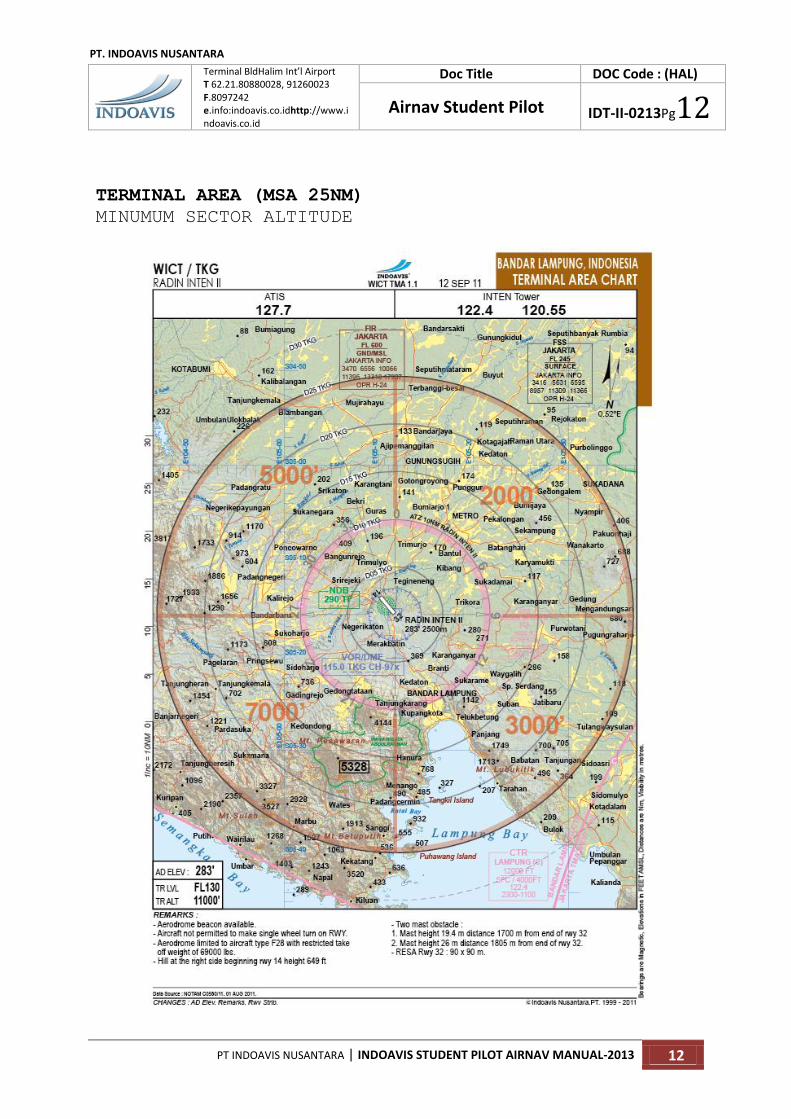
VFR Terminal Chart is a chart which provide graphical view to the Pilot within the Radius Area of 30Nm from the Aerodrome Navigational Equipment. This chart also provide visualization to the Pilots where the 25Nm MSA (Minimum Safety Altitude) are, and provided with Safe Flights Altitude. Chart Scale : 1In = 10Nm Grid Distance : 10 Menit Type of Altitude : Feet Type Of Distance : Nautical Mile Contour Interval : 250 feet / 120 feet Chart Dimension : A5 (21 x 25Cm) Paper Type : Gress 80Gr Bearing : Magnetic bearing
IV. BASIC REFERENCE STANDARDS Reference and the use of graphical data processing is using GIS software, reference parameters are based on ICAO documents. For Topographical datas, the SRTM is used. For Aeronautical data the source are from the AIP of each State, while for periodic changes, Indoavis is using the source data from the AIP Supplement, AIP Amendment and Permanent NOTAM data.
A. DATA REFERENCES
a. AIP (Aeronautical Information Publication) Indonesia, Malaysia, Singapore
b. AIP Supplement / AIP Amendment and NOTAM Perm
c. SRTM (Shuttle Radar Topography Mission)
d. RBI (Rupa Bumi Indonesia)
B. DOCUMENT REFERENCES a. ICAO-Annex 4 (Aeronautical Chart)
b. ICAO-Annex 15 (Aeronautical Information Services)
c. ICAO-Doc 8697 (Aeronautical Chart Manual)
d. ICAO-Doc 8126 (Aeronautical Information Services Manual)
e. ICAO-Doc 8400 (Procedure for Air Navigation Services)
f. ICAO-Doc 8168 (Air Navigation Services Aircraft Operation Flight Procedure)
g. ICAO-Doc 9674 (World Geodetic System -1984 (WGS 84) Manual
PT. INDOAVIS NUSANTARA Geo-informatics and Aeronautical Information Services
2nd Floor Terminal Building A-02/PK HalimPerdanaKusuma International Airport Jakarta (13610) INDONESIA
Phone : 62-21-808 80028, 62-21-912 600238 Fax : 62-21-8097242 W-site : http://www.indoavis.co.id :http://www.indoavis.net :http://www.indoavis.org Email : [email protected] / [email protected]
V. INFORMATION COUNTACT

PT. INDOAVIS NUSANTARA
Terminal BldHalim Int’l Airport T 62.21.80880028, 91260023 F.8097242 e.info:indoavis.co.idhttp://www.indoavis.co.id
Doc Title DOC Code : (HAL)
Airnav Student Pilot IDT-II-0213Pg6
PT INDOAVIS NUSANTARA | INDOAVIS STUDENT PILOT AIRNAV MANUAL-2013 6
DATA REQUIREMENTS
LIST OF FORM
To produce and publish the "STUDENT PILOT MANUAL AIRNAV"
product, Indoavis would need some data to be filled, and must
be completed, as stipulated below:
NO TITLE RESULT 1. NAMA OF FLYING
SCHOOL
2. AIRPORT BASE
OPERATION
3. OTHER AIRPORTS
3. TRAINING AREA
LOCATION
4. TYPES OF
AIRCRAFT
5. CROSS COUNTRY
ROUTE
1.
2.
3.
6. TRIANGEL
EXERCISE ROUTE
7. IN/OUTBOUND
LOCAL PROCEDURE
CHART
8. AIRPORT CIRCUIT
PROFILE
9. LOST POSITION
PROCEDURE
AND INFORMATION
CONTACTS
NOTES : ………………………………………………………………………..………………………………………………………………………… ………………………………………………………………..………………………………………………………………………………… ………………………………………………………………..………………………………………………………………………………… ………………………………………………………………..………………………………………………………………………………… ………………………………………………………………..…………………………………………………………………………………

PT. INDOAVIS NUSANTARA
Terminal BldHalim Int’l Airport T 62.21.80880028, 91260023 F.8097242 e.info:indoavis.co.idhttp://www.indoavis.co.id
Doc Title DOC Code : (HAL)
Airnav Student Pilot IDT-II-0213Pg7
PT INDOAVIS NUSANTARA | INDOAVIS STUDENT PILOT AIRNAV MANUAL-2013 7
SAMPLE OF PRODUCTs
Sub
Regulation
Information
BACK COVER
PT. INDOAVIS NUSANTARA
Terminal BldHalim Int’l Airport T 62.21.80880028, 91260023 F.8097242 e.info:indoavis.co.idhttp://www.indoavis.co.id
Doc Title DOC Code : (HAL)
Airnav Student Pilot IDT-II-0213Pg8
PT INDOAVIS NUSANTARA | INDOAVIS STUDENT PILOT AIRNAV MANUAL-2013 8
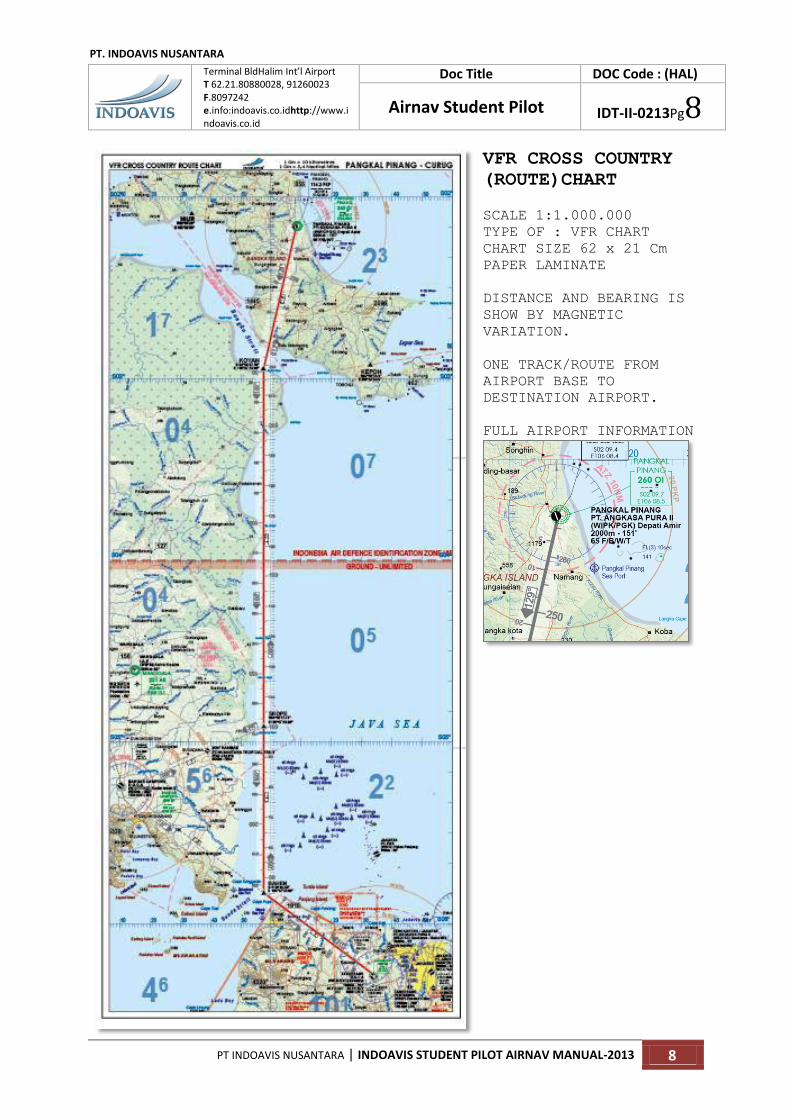
VFR CROSS COUNTRY
(ROUTE)CHART
SCALE 1:1.000.000
TYPE OF : VFR CHART
CHART SIZE 62 x 21 Cm
PAPER LAMINATE
DISTANCE AND BEARING IS
SHOW BY MAGNETIC
VARIATION.
ONE TRACK/ROUTE FROM
AIRPORT BASE TO
DESTINATION AIRPORT.
FULL AIRPORT INFORMATION

PT. INDOAVIS NUSANTARA
Terminal BldHalim Int’l Airport T 62.21.80880028, 91260023 F.8097242 e.info:indoavis.co.idhttp://www.indoavis.co.id
Doc Title DOC Code : (HAL)
Airnav Student Pilot IDT-II-0213Pg9
PT INDOAVIS NUSANTARA | INDOAVIS STUDENT PILOT AIRNAV MANUAL-2013 9
TRAINING AREA CHART
SCALE 1:250.000
TYPE OF: VFR CHART
CHART SIZE 50 x 21 Cm
PAPER LAMINATE
SAMPLE ONLY NOT FOR NAVIGATION USE.!

PT. INDOAVIS NUSANTARA
Terminal BldHalim Int’l Airport T 62.21.80880028, 91260023 F.8097242 e.info:indoavis.co.idhttp://www.indoavis.co.id
Doc Title DOC Code : (HAL)
Airnav Student Pilot IDT-II-0213Pg10
PT INDOAVIS NUSANTARA | INDOAVIS STUDENT PILOT AIRNAV MANUAL-2013 10
TERMINAL CHART (IAP)
Instrument Approach Chart
(ILS, VOR, VOR/DME, NDB)

PT. INDOAVIS NUSANTARA
Terminal BldHalim Int’l Airport T 62.21.80880028, 91260023 F.8097242 e.info:indoavis.co.idhttp://www.indoavis.co.id
Doc Title DOC Code : (HAL)
Airnav Student Pilot IDT-II-0213Pg11
PT INDOAVIS NUSANTARA | INDOAVIS STUDENT PILOT AIRNAV MANUAL-2013 11
SAMPLE ONLY NOT FOR NAVIGATION USE.!
TERMINAL CHART (SID – STAR)
ARRIVAL AND DEPARTURE CHART
SAMPLE ONLY NOT FOR NAVIGATION USE.!
PT. INDOAVIS NUSANTARA
Terminal BldHalim Int’l Airport T 62.21.80880028, 91260023 F.8097242 e.info:indoavis.co.idhttp://www.indoavis.co.id
Doc Title DOC Code : (HAL)
Airnav Student Pilot IDT-II-0213Pg12
PT INDOAVIS NUSANTARA | INDOAVIS STUDENT PILOT AIRNAV MANUAL-2013 12
TERMINAL AREA (MSA 25NM)
MINUMUM SECTOR ALTITUDE