late pliocene megafossils of the pico ...hcgeo004/newhall.pdflate pliocene megafossils of the pico...
TRANSCRIPT

LATE PLIOCENE MEGAFOSSILS OF THE PICO FORMATION, NEWHALL AREA,LOS ANGELES COUNTY, SOUTHERN CALIFORNIA
1
RICHARD L. SQUIRES2
ABSTRACT. Taxonomic composition and stratigraphic distribution of megafossils in the Pico Formation south of Newhall, northern LosAngeles County, Southern California, are described in detail. Eighty-three taxa, from 15 localities, were found: one brachiopod, 36bivalves, 40 gastropods, one scaphopod, one crab, one barnacle, one sea urchin, one shark, and one land plant. All are illustrated here. Thepectinid bivalve Argopecten invalidus (Hanna, 1924) is put into synonymy with A. subdolus (Hertlein, 1925) and A. callidus (Hertlein,1925). Rare specimens of the gastropods Calliostoma and Ocinebrina might be new species.
The mollusks, which are indicative of a late Pliocene age, lived in waters of inner sublittoral depths and normal marine salinity. Most ofthe 41 extant species indicate warm-temperate waters similar to those occurring today off the adjacent coast, although a few species, bothextant and extinct, indicate a southerly warmer water component. The fauna lived predominantly in, or on, soft sands, but a few lived onother shells or possibly on large rock clasts.
Geologic field mapping done as part of this present study revealed that the Pico Formation south of Newhall was deposited at the site wherea braided river entered the marine environment (i.e., braid delta). Initially, the river gravel and coarse sand interfingered with relatively deepoffshore silts, barren of megafauna, in the lower and middle parts of the formation. Eventually, the delta built up, and the resulting shoalingconditions in the upper part of the formation were conducive for the megafauna to live in, or immediately adjacent to, the deltaic shorefacefine sands. Storm waves raked the delta and concentrated the shells of the megafauna, along with cobbles of igneous and metamorphicbasement rocks, into channelized deposits. Postmortem transport distance was short, as evidenced by many paired-valved bivalve shells.
INTRODUCTION
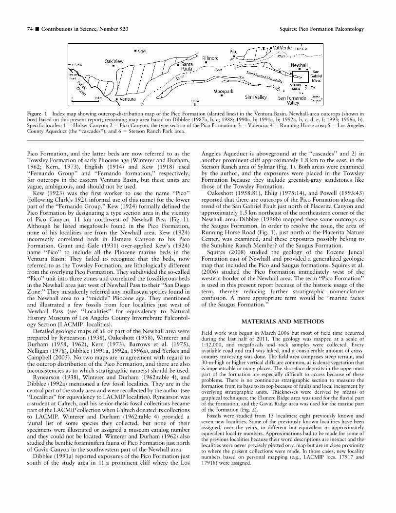
During the Pliocene, the Pico Formation was deposited for adistance of approximately 92 km along the axis of the VenturaBasin, which trends parallel to the present course of the modernSanta Clara River in Southern California (Fig. 1). The formationhas its broadest extent of outcrops in the Ventura area, and theoutcrop pattern narrows significantly eastward toward theNewhall area. The Pico Formation represents the youngestmarine deposits in the eastern Ventura Basin. Throughout mostof this basin, the Pico Formation is an offshore-marine sequenceconsisting of siltstone, mudstone, and claystone with some minoramounts of sandstone and conglomerate. Megafossils are sparse,but relatively deep-water benthic foraminifera are common. Tothe east, toward Val Verde and Valencia (Fig. 1), the formationbecomes increasingly sandier and conglomeratic, and shallow-marine gastropods and bivalves are locally common in the upperpart (Grant and Gale, 1931; Squires et al., 2006). The purposesof this present study are to 1) determine how far east the shallow-marine megafossiliferous beds continue beyond the Valencia areainto the stratigraphically and structurally complex Newhall area,2) tabulate and illustrate the taxonomic composition of themegafauna, and 3) establish its age, depositional environment,and zoogeographic implications.
All preexisting geologic maps (e.g., Winterer and Durham,1958, 1962; Dibblee, 1991a, 1992a) of the Newhall area areinconsistent in regard to 1) the differentiation of the PicoFormation from the other Neogene stratigraphic units in the area(i.e., Towsley Formation, Saugus Formation, and Sunshine RanchMember of the Saugus Formation), 2) the structural geology ofthe area, and 3) the depositional environments the PicoFormation. Also, no previous detailed megafossil investigations
were done. It was necessary, therefore, to do my own geologicmapping in order to understand the fundamental geologicrelationships of the easternmost Pico Formation in the VenturaBasin. The outcome is that the Pico Formation in the Newhallarea is recognized for the first time as having been deposited in abraid-delta environment. This study is important because itaffords the unusual opportunity to observe the complex inter-fingering between the fluvial and marine components of aTertiary-age, predominantly marine formation in SouthernCalifornia. The study area encompasses where the two environ-ments interfinger for a lateral distance of approximately 5 km,and the lateral-fluvial component extends eastward for anadditional 3 km (Fig. 2).
There might be a few small outcrops of the Pico formation justsouth and southeast of the study area in the San Fernando Valley(e.g., Lopez Canyon) (Chen, 1988) and, possibly, a fault-bounded, small outcrop approximately 22 km southeast ofNewhall (Berry et al., 2009) in Gold Creek, a tributary of BigTujunga Canyon.
PREVIOUS WORK
The earliest work on fossils from the study area was by Gabb(1869:49), who described a few species of Pliocene mollusks froman area originally referred to as Fremont Pass, later known as SanFernando Pass, and now known as Newhall Pass, located just northof the junction of U.S. Interstate 5 and California State Highway14. Ashley (1895:338) listed some mollusks from the same generalarea. None of his specimens were illustrated nor were they assigneda museum catalog number; they could not be located.
Eldridge and Arnold (1907:22) used the name ‘‘Fernando’’ foran enormous section of siliciclastics, largely of Pliocene age, thatcrops out over a considerable area of Southern California,including the study area. Instead of basing the section onlithology, they improperly based it on three megafossil zones(collectively of Pliocene age). They erroneously lumped fossilsfound in Newhall Pass and Elsmere Canyon, but they listed onlythe fossils from Elsmere Canyon. The former beds belong to the
1 URL: www.nhm.org/scholarlypublications2 Department of Geological Sciences, California State University,
18111 Nordhoff Street, Northridge, California, 91330-8266, USA;Research Associate, Invertebrate Paleontology, Natural History Museumof Los Angeles County, 900 Exposition Boulevard, Los Angeles,California, 90007, USA. E-mail: [email protected]
Contributions in Science, 520:73–93 21 December 2012
E Natural History Museum of Los Angeles County, 2012ISSN 0459-8113 (Print); 2165-1868 (Online)
Pico Formation, and the latter beds are now referred to as theTowsley Formation of early Pliocene age (Winterer and Durham,1962; Kern, 1973). English (1914) and Kew (1918) used‘‘Fernando Group’’ and ‘‘Fernando formation,’’ respectively,for outcrops in the eastern Ventura Basin, but these units arevague, ambiguous, and should not be used.
Kew (1923) was the first worker to use the name ‘‘Pico’’(following Clark’s 1921 informal use of this name) for the lowerpart of the ‘‘Fernando Group.’’ Kew (1924) formally defined thePico Formation by designating a type section area in the vicinityof Pico Canyon, 11 km northwest of Newhall Pass (Fig. 1).Although he listed megafossils found in the Pico Formation,none of his localities are from the Newhall area. Kew (1924)incorrectly correlated beds in Elsmere Canyon to his PicoFormation. Grant and Gale (1931) over-applied Kew’s (1924)name ‘‘Pico’’ to include all the Pliocene marine beds in theVentura Basin. They failed to recognize that the beds, nowreferred to as the Towsley Formation, are lithologically differentfrom the overlying Pico Formation. They subdivided the so-called‘‘Pico’’ unit into three zones and correlated the fossiliferous bedsin the Newhall area just west of Newhall Pass to their ‘‘San DiegoZone.’’ They mistakenly referred any molluscan species found inthe Newhall area to a ‘‘middle’’ Pliocene age. They mentionedand illustrated a few fossils from four localities just west ofNewhall Pass (see ‘‘Localities’’ for equivalency to NaturalHistory Museum of Los Angeles County Invertebrate Paleontol-ogy Section [LACMIP] localities).
Detailed geologic maps of all or part of the Newhall area wereprepared by Rynearson (1938), Oakeshott (1958), Winterer andDurham (1958, 1962), Kern (1973), Barrows et al. (1975),Nelligan (1978), Dibblee (1991a, 1992a, 1996a), and Yerkes andCampbell (2005). No two maps are in agreement with regard tothe outcrop distribution of the Pico Formation, and there are alsoinconsistencies as to which stratigraphic name(s) should be used.
Rynearson (1938), Winterer and Durham (1962:table 4), andDibblee (1992a) mentioned a few fossil localities. They are in thecentral part of the study area and were recollected by the author (see‘‘Localities’’ for equivalency to LACMIP localities). Rynearson wasa student at Caltech, and his senior-thesis fossil collections becamepart of the LACMIP collection when Caltech donated its collectionsto LACMIP. Winterer and Durham (1962:table 4) provided afaunal list of some species they collected, but none of theirspecimens were illustrated or assigned a museum catalog numberand they could not be located. Winterer and Durham (1962) alsostudied the benthic foraminifera fauna of Pico Formation just northof Gavin Canyon in the southwestern part of the Newhall area.
Dibblee (1991a) reported exposures of the Pico Formation justsouth of the study area in 1) a prominent cliff where the Los
Angeles Aqueduct is aboveground at the ‘‘cascades’’ and 2) inanother prominent cliff approximately 1.8 km to the east, in theStetson Ranch area of Sylmar (Fig. 1). Both areas were examinedby the author, and the exposures were placed in the TowsleyFormation because they include greenish-gray sandstones likethose of the Towsley Formation.
Oakeshott (1958:81), Ehlig (1975:14), and Powell (1993:43)reported that there are outcrops of the Pico Formation along thetrend of the San Gabriel Fault just north of Placerita Canyon andapproximately 1.5 km northeast of the northeastern corner of theNewhall area. Dibblee (1996b) mapped these same outcrops asthe Saugus Formation. In order to resolve the issue, the area ofRunning Horse Road (Fig. 1), just north of the Placerita NatureCenter, was examined, and these exposures possibly belong tothe Sunshine Ranch Member? of the Saugus Formation.
Squires (2008) studied the geology of the Eocene JuncalFormation east of Newhall and provided a generalized geologicmap that included the Pico and Saugus formations. Squires et al.(2006) studied the Pico Formation immediately west of thewestern border of the Newhall area. The term ‘‘Pico Formation’’is used in this present report because of the historic usage of theterm, thereby reducing further stratigraphic nomenclatureconfusion. A more appropriate term would be ‘‘marine faciesof the Saugus Formation.’’
MATERIALS AND METHODS
Field work was begun in March 2006 but most of field time occurredduring the last half of 2011. The geology was mapped at a scale of1:12,000, and megafossils and rock samples were collected. Everyavailable road and trail was hiked, and a considerable amount of cross-country traversing was done. The field area comprises steep terrain, and30-m-high or higher vertical cliffs are common, as is dense vegetation thatis impenetrable in many places. The shoreface deposits in the uppermostpart of the formation are especially difficult to access because of theseproblems. There is no continuous stratigraphic section to measure theformation from its base to its top because of faults and local incisement byoverlying stratigraphic units. Thicknesses were derived by means ofgraphical techniques: the Elsmere Ridge area was used for the fluvial partof the formation, and the Gavin Ridge area was used for the marine partof the formation (Fig. 2).
Fossils were studied from 15 localities: eight previously known andseven new localities. Some of the previously known localities have beenassigned, over the years, to different but equivalent or approximatelyequivalent locality numbers. Approximations had to be made for some ofthe previous localities because their word descriptions are inexact and thelocalities were never precisely plotted on a map but are in close proximityto where the present collections were made. In those cases, new localitynumbers based on personal mapping (e.g., LACMIP locs. 17917 and17918) were assigned.
Figure 1 Index map showing outcrop-distribution map of the Pico Formation (slanted lines) in the Ventura Basin. Newhall-area outcrops (shown inbox) based on this present report; remaining map area based on Dibblee (1987a, b, c; 1988; 1990a, b; 1991a, b; 1992a, b, c, d, e, f; 1993; 1996a, b).Specific locales: 1 5 Holser Canyon; 2 5 Pico Canyon, the type section of the Pico Formation; 3 5 Valencia; 4 5 Running Horse area; 5 5 Los AngelesCounty Aqueduct (the ‘‘cascades’’); and 6 5 Stetson Ranch Park area.
74 & Contributions in Science, Number 520 Squires: Pico Formation Paleontology

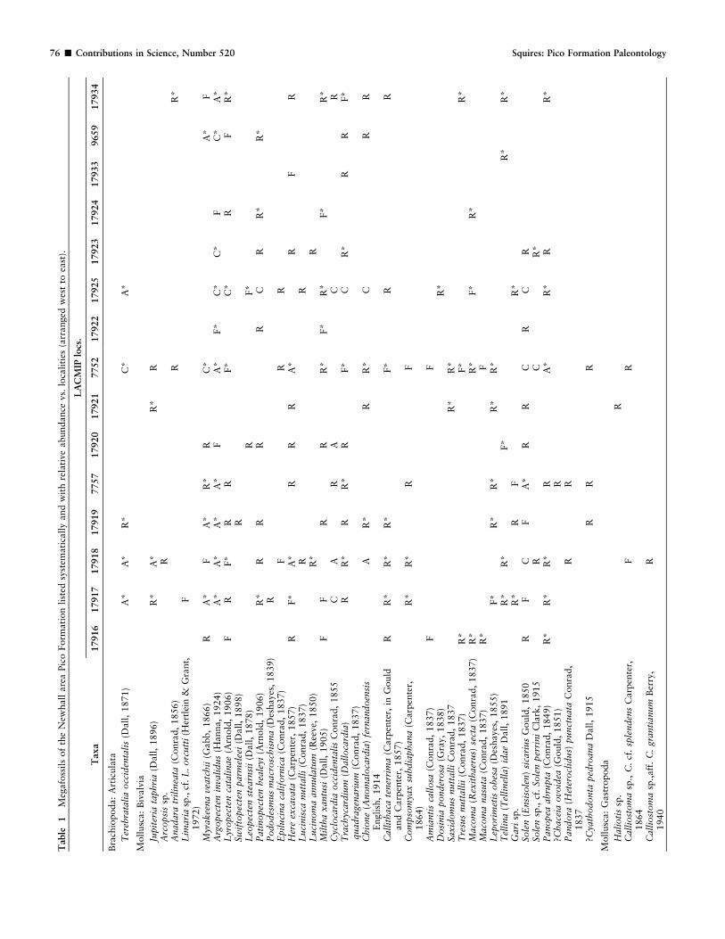
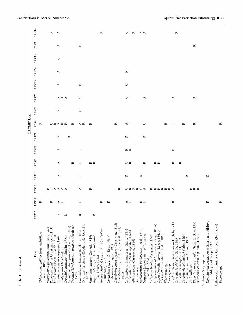
A total of 2020 specimens were studied, and approximately half ofthese specimens were personally collected. The figured specimens, as wellas all the other megafossils collected in the course of this study, weredeposited in the LACMIP collection.
Matrix was removed from the fossils by the use of hammer and chisel,and, for fine cleaning, a high-speed drill. A systematic treatment for eachmegafaunal species is not given here because no new information wasgleaned for most of the species collected during the present study.Previous synonymies, distinctive morphologic characters, and stratigraph-ic distributions, etc. are available for most of the species in works such asArnold (1903), Grant and Gale (1931), Hertlein and Grant (1972),Groves (1991), Davis (1998), and Squires et al. (2006). New informationis given here in the ‘‘Systematics’’ section for newly recognized synonymsof the pectinid Argopecten invalidus and for two potential new species ofgastropods. Figures of the taxa listed in Table 1 are included here in orderto verify this list, and the numerical order of these figures corresponds tothe systematic organization used for the faunal list.
ABBREVIATIONS: Abbreviations used for locality and/or catalognumbers are CAS (California Academy of Sciences, San Francisco;includes the Stanford University [SU] collection), and LACMIP (NaturalHistory Museum of Los Angeles County, Invertebrate PaleontologySection).
LOCALITIES
All are LACMIP localities in the Pico Formation of upperPliocene age, and located relative to the United States GeologicalSurvey Oat Mountain Quadrangle (7.5 minute), 1952 (photo-revised 1969), Los Angeles County, southern California.
7725. 118u319400W, 34u209350N. Elevation 549 m (1800 ft.),crest of spur at base of power-line tower, 703 m (2300 ft.) northand 703 m (2300 ft.) west of southeast corner of section 14.
Collectors: H.M. Rice (circa early 1930s) and R.L. Squires,October 1, 2011. 7752 [= 5547]. 118u319150W, 34u219080N.Elevation 427 m (1400 ft.), northeast of trailer park in north–south-trending canyon, on south section-line, 91 m (300 ft.) eastof northeast corner of section 14. Locality represents floatmaterial from a bed located a short distance to the north at thehead of a box canyon with inaccessible vertical cliffs. Collectors:H.M. Rice (circa early 1930s); L.G. Barnes and G. Campbell,April 1965; and R.L. Squires, October 9, November 13, andDecember 4, 2011. 7757. 118u329330W, 34u219150N. Elevation525 m (1725 ft.), on ridgeline, 290 m (950 ft.) north and 1036 m(3400 ft.) east of southwest corner of section 10. Collectors:H.M. Rice (circa early 1930s) and R.L. Squires, October 21,2011. 9659. 118u319140W, 34u209340N. Elevation 637 m(2090 ft.), on ridgeline, 655 m (2150 ft.) north and 381 m(1250 ft.) east of southwest corner of section 24. Collectors: G.A.Rynearson (1938) and R.L. Squires, September 4, 2011.Equivalent to loc. 212 of Grant and Gale (1931:102). 17916.118u329490W, 34u219330N. Elevation 434 m (1425 ft.), southside of disused road near south end of housing tract south ofCalgrove Blvd., 899 m (2950 ft.) north and 168 m (550 ft.) eastof southwest corner of section 10, T 3 N, R 16 W. Collector: R.L.Squires, October 21, 2011. 17917 [= 7761 and approximately7226 and 10339]. 118u32947.50W, 34u219300N. Elevation 480 m(1575 ft.), east side of power line road east of Gavin Canyon,747 m (2450 ft.) and 213 m (700 ft.) east of southwest corner ofsection 10, T 3 N, R 16 W. Collectors: H.M. Rice (circa early1930s); G.M. Dorwat, March 22, 1943; C.R. Stauffer, 1949; andR.L. Squires, October 21, 2011. 17918 [= 7760]. 118u329480W,34u219280N. Elevation 450 m (1475 ft.), north side of power line
Figure 2 Geologic map of the study area south of Newhall, northern Los Angeles County, California.
Contributions in Science, Number 520 Squires: Pico Formation Paleontology & 75
Table
1M
egaf
oss
ils
of
the
New
hall
are
aPic
oForm
ati
on
list
edsy
stem
ati
call
yand
wit
hre
lati
ve
abundance
vs.
loca
liti
es(a
rranged
wes
tto
east
).
Taxa
LA
CM
IPlo
cs.
17916
17917
17918
17919
7757
17920
17921
7752
17922
17925
17923
17924
17933
9659
17934
Bra
chio
poda:
Art
icula
ta
Ter
ebra
talia
occ
iden
tali
s(D
all,
1871)
A*
A*
R*
C*
A*
Moll
usc
a:
Biv
alv
ia
Jupit
eria
taphri
a(D
all,
1896)
R*
A*
R*
RA
rcopsi
ssp
.R
Anad
ara
tril
inea
ta(C
onra
d,
1856)
RR
*L
imar
iasp
.,cf
.L
.orc
utt
i(H
ertl
ein
&G
rant,
1972)
F
Myr
akee
na
veat
chii
(Gabb,
1866)
RA
*F
A*
R*
RC
*A
*F
Arg
opec
ten
inva
lidus
(Hanna,
1924)
A*
A*
A*
A*
FA
*F*
C*
C*
FC
*A
*L
yropec
ten
cata
linae
(Arn
old
,1906)
FR
F*
RR
F*
C*
RF
R*
Swif
topec
ten
par
mel
eei
(Dall,
1898)
RL
eopec
ten
stea
rnsi
i(D
all,
1878)
RF*
Pat
inopec
ten
hea
leyi
(Arn
old
,1906)
R*
RR
RR
CR
R*
R*
Pododes
mus
mac
rosc
his
ma
(Des
hayes
,1839)
RE
piluci
na
califo
rnic
a(C
onra
d,
1837)
FR
RH
ere
exca
vata
(Car
pen
ter,
1857)
RF*
A*
RR
RA
*R
FR
Luci
nis
canutt
alli
(Conra
d,
1837)
RR
Luci
nom
aan
nula
tum
(Ree
ve,
1850)
R*
RM
ilth
axan
tusi
(Dall,
1905)
FF
RR
R*
F*
R*
F*
R*
Cyc
loca
rdia
occ
iden
tali
sC
onra
d,
1855
CA
RA
CR
Tra
chyc
ardiu
m(D
allo
card
ia)
quad
rage
nar
ium
(Conra
d,
1837)
RR
*R
R*
RF*
CR
*R
RF*
Chio
ne
(Anom
aloca
rdia
)fe
rnan
doen
sis
Engli
sh,
1914
AR
*R
R*
CR
R
Cal
lith
aca
tener
rim
a(C
arpen
ter,
inG
ould
and
Carp
ente
r,1857)
RR
*R
*R
*F*
RR
Com
pso
mya
xsu
bdia
phan
a(C
arpen
ter,
1864)
R*
R*
RF
Am
ianti
sca
llosa
(Conra
d,
1837)
FF
Dosi
nia
ponder
osa
(Gra
y,
1838)
R*
Saxid
om
us
nutt
alli
Conra
d,
1837
R*
R*
Tre
sus
nutt
allii
(Conra
d,
1837)
R*
F*
R*
Mac
om
a(R
exit
hae
rus)
sect
a(C
onra
d,
1837)
R*
R*
F*
R*
Mac
om
anas
uta
(Conra
d,
1837)
R*
FL
epori
met
isobes
a(D
eshaye
s,1855)
F*
R*
R*
R*
R*
Tel
lina
(Tel
linel
la)
idae
Dall,
1891
R*
R*
F*
R*
R*
Gar
isp
.R
*R
FR
*So
len
(Ensi
sole
n)
sica
rius
Gould
,1850
RF
CF
A*
RR
CR
CR
Sole
nsp
.,cf
.So
len
per
rini
Cla
rk,
1915
RC
R*
Pan
opea
abru
pta
(Conra
d,
1849)
R*
R*
R*
RA
*R
*R
R*
?Chac
eia
ovo
idea
(Gould
,1851)
RP
andora
(Het
erocl
idus)
punct
uat
aC
onra
d,
1837
RR
?Cya
thodonta
ped
roan
aD
all
,1915
RR
R
Moll
usc
a:
Gast
ropoda
Hal
ioti
ssp
.R
Cal
liost
om
asp
.,C
.cf
.sp
lenden
sC
arp
ente
r,1864
FR
Cal
liost
om
asp
.,af
f.C
.gr
anti
anum
Ber
ry,
1940
R
76 & Contributions in Science, Number 520 Squires: Pico Formation Paleontology
Taxa
LA
CM
IPlo
cs.
17916
17917
17918
17919
7757
17920
17921
7752
17922
17925
17923
17924
17933
9659
17934
Chlo
rost
om
aga
llin
afo
rmm
ult
ifilosa
Ste
arn
s,1892
RF
Hom
oplo
ma
pau
cico
stat
um
?(D
all,
1871)
RP
om
aula
xgr
adat
aG
rant
and
Gal
e,1931
RF
CR
Lir
obit
tium
asper
um
(Gabb,
1861)
AR
Turr
itel
laco
oper
iC
arp
ente
r,1864
AA
AA
AA
FA
FA
AA
CA
A?C
alyp
trae
a(T
roch
ita)
sp.
FA
RR
Cre
pid
ula
acule
ata
(Gm
elin
,1791)
RA
RA
Gra
ndic
repid
ula
pri
nce
ps
(Conra
d,
1857)
RZ
onar
ia(N
eober
nay
a)sp
adic
ea(S
wain
son,
1823)
RR
Glo
ssau
lax
recl
usi
ana
(Des
hayes
,1839)
RF
AF
FF
AR
CR
RC
rypto
nat
ica
clau
sa(B
roder
ip&
Sow
erby,
1829)
R
Sinum
scopulo
sum
(Conra
d,
1849)
RR
RA
sper
isca
lasp
.,cf
.A
.m
inuti
cost
ata
(De
Boury
,1912)
RR
Am
aea
(Sca
lina)
sp.,
cf.
A.
(S.)
edw
ilso
ni
DuShane,
1977
RR
Cym
atiu
msp
.,cf
.C
.(R
etic
utr
iton)
elsm
eren
se(E
ngl
ish,
1914)
R
Oci
neb
rina
atro
purp
ure
a(C
arpen
ter,
1865)
RO
cineb
rina
sp.,
aff
.O
.fr
aser
i(O
ldro
yd,
1920)
R
Cal
ican
thar
us
hum
erosu
s(G
abb,
1869)
AC
RC
RR
AC
CR
CC
alic
anth
arus
fort
is(C
arp
ente
r,1864)
FR
RR
Ali
atu
ber
osa
(Car
pen
ter,
1864)
FR
Am
phis
sasp
.R
Bar
bar
ofu
sus
bar
bar
ensi
s(T
rask
,1855)
RC
RR
Nas
sari
us
(Dem
ondia
)ca
lifo
rnia
nus
(Conra
d,
1856)
FA
RR
CA
A
Cal
lian
axbae
tica
(Carp
ente
r,1864)
RC
alif
orn
iconusc
alif
orn
icus?
(Ree
ve,
1843a)
RR
Ophio
der
mel
lain
erm
is(R
eeve
,1843b)
RR
Cock
erel
laco
nra
dia
na
(Gabb,
1866)
RE
laeo
cym
asp
.R
RC
rass
ispir
asp
.R
Ter
ebra
(Str
iote
rebra
)m
arti
ni
Engli
sh,
1914
RA
RR
FR
RC
ance
llar
iaal
tisp
ira
Gabb,
1869
RC
ance
llar
iahem
phil
liD
all
,1909
RC
ance
llar
iatr
itonid
ea?
Gab
b,
1866
RC
ance
llar
iaham
lini
Cars
on,
1926
RT
urb
onil
lasp
.R
Ric
taxis
pai
nei
gran
dio
rG
rant
&G
ale
,1931
RR
RR
Act
eoci
na
culc
itel
la?
(Gould
,1853)
R
Moll
usc
a:
Sca
phopoda
Den
tali
um
neo
hex
agonum
Shar
pand
Pil
sbry
,in
Pil
sbry
and
Sharp
,1897
RR
Art
hro
poda:
Cru
stace
a:
Cir
riped
ia(b
arnacl
es)
Bal
anus?
sp.
RR
Table
1C
onti
nued
.Contributions in Science, Number 520 Squires: Pico Formation Paleontology & 77
road east of Gavin Canyon, 701 m (2300 ft.) north and 267 m(875 ft.) east of southwest corner of section 10, T 3 N, R 16 W.Collectors: G.M. Dorwat, March 22, 1943, and R.L. Squires,October 21, 2011. 17919. 118u329380W, 34u21916.50N. Eleva-tion 506 m (1660 ft.), on ridgeline just below ‘‘0’’ in ‘‘10,’’ 480 m(1575 ft.) north and 777 m (2550 ft.) east of southwest corner ofsection 10, T 3 N, R 16 W. Collector: R.L. Squires, November 7,2010, and October 21, 2011. 17920. 118u329300W, 34u219120N.Elevation 518 m (1700 ft.), on ridgeline 259 m (850 ft.) northand 419 m (1375 ft.) west of southeast corner of section 10, T 3N, R 16 W. Collector: R.L. Squires, December 10, 2011. 17921.118u329220W, 34u219,100N. Elevation 549 m (1800 ft.), onridgeline 152 m (500 ft.) north and 129 m (425 ft.) west ofsoutheast corner of section 10, T 3 N, R 16 W. Collector: R.L.Squires, December 10, 2011. 17922. 118u329140W, 34u219000N.Elevation 479 m (1570 ft.), on east side of power line road justeast of trailer park, 198 m (650 ft.) south and 122 m (400 ft.) eastof northwest corner of section 14. Collector: R.L. Squires,October 9, 2011. 17923. 118u319400W, 34u20935.50N. Elevation610 m (2000 ft.), 739 m (2425 ft.) north and 533 m (1750 ft.)west of southeast corner of section 14. Collector: R.L. Squires,September 4, 2011. Equivalent to southernmost loc. of Dibblee(1992a). 17924. 118u319380W, 34u209530N. Elevation 632 m(2075 ft.), on north–south-trending ridgeline, 1204 m (3950 ft.)north and 488 m (1600 ft.) west of southeast corner of section14. Collector: R.L. Squires, September 25, 2011. Equivalent toloc. 213 of Grant and Gale (1931:102) and to the northernmostloc. of both Rynearson (1938) and Dibblee (1992a). 17933.118u319160W, 34u209350N. Elevation 582 m (1910 ft.), smalloutcrop north side of road along ridgeline, 671 m (2200 ft.) northand 183 m (600 ft.) east of southwest corner of section 13.Collector: R.L. Squires, September 4, 2011. 17934 [= approx-imately 422, 4720, and 7797]. 118u309220W, 34u209150N.Elevation 552 m (1810 ft.), on east side of power line road justnorth of small concrete building, 30 m (100 ft.) north and 975 m(3200 ft.) east of southwest corner of section 13. Collectors: G.P.Kanakoff (date unknown), G.A. Rynearson (1938), and R.L.Squires, September 4, 2011. In vicinity of locs. 211 and 214 ofGrant and Gale (1931:102) and loc. F76 of Winterer andDurham (1962).
STRATIGRAPHY AND DEPOSITIONAL ENVIRONMENTS
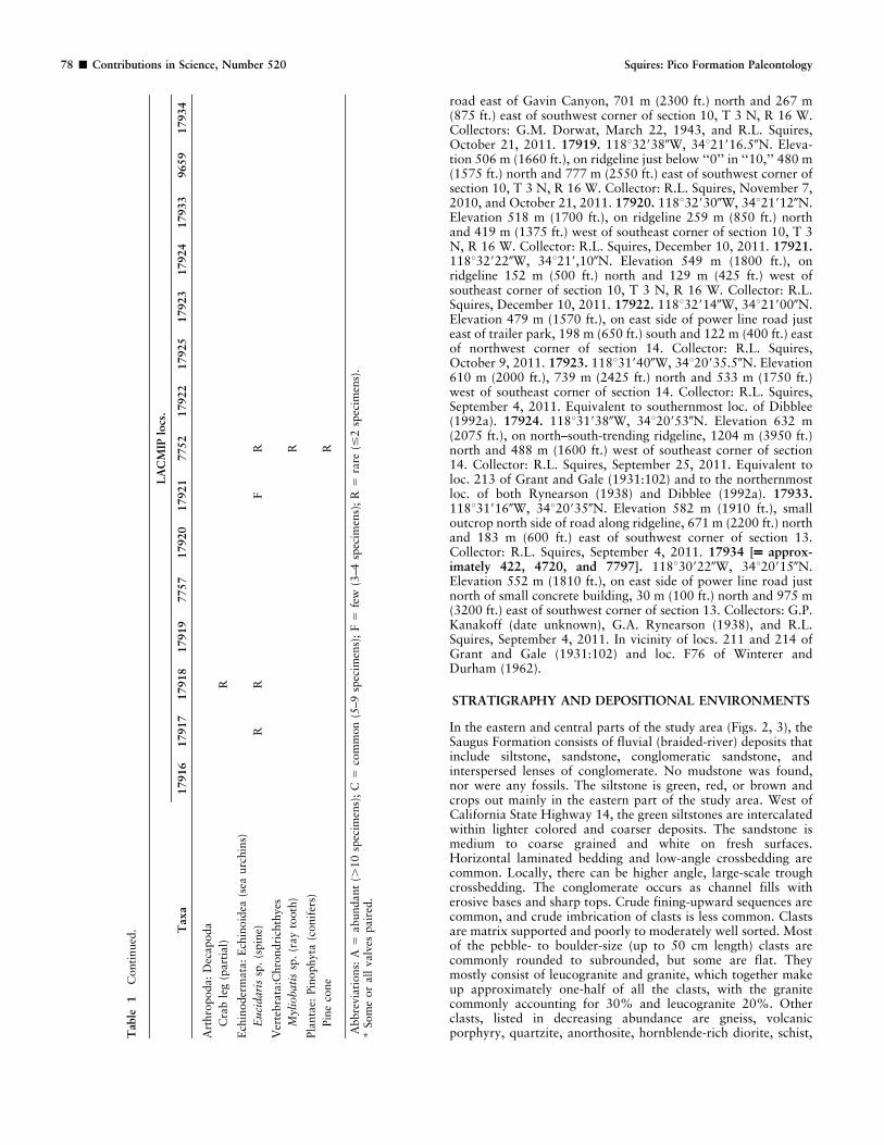
In the eastern and central parts of the study area (Figs. 2, 3), theSaugus Formation consists of fluvial (braided-river) deposits thatinclude siltstone, sandstone, conglomeratic sandstone, andinterspersed lenses of conglomerate. No mudstone was found,nor were any fossils. The siltstone is green, red, or brown andcrops out mainly in the eastern part of the study area. West ofCalifornia State Highway 14, the green siltstones are intercalatedwithin lighter colored and coarser deposits. The sandstone ismedium to coarse grained and white on fresh surfaces.Horizontal laminated bedding and low-angle crossbedding arecommon. Locally, there can be higher angle, large-scale troughcrossbedding. The conglomerate occurs as channel fills witherosive bases and sharp tops. Crude fining-upward sequences arecommon, and crude imbrication of clasts is less common. Clastsare matrix supported and poorly to moderately well sorted. Mostof the pebble- to boulder-size (up to 50 cm length) clasts arecommonly rounded to subrounded, but some are flat. Theymostly consist of leucogranite and granite, which together makeup approximately one-half of all the clasts, with the granitecommonly accounting for 30% and leucogranite 20%. Otherclasts, listed in decreasing abundance are gneiss, volcanicporphyry, quartzite, anorthosite, hornblende-rich diorite, schist,T
able
1C
onti
nued
. Taxa
LA
CM
IPlo
cs.
17916
17917
17918
17919
7757
17920
17921
7752
17922
17925
17923
17924
17933
9659
17934
Art
hro
poda:
Dec
apoda
Cra
ble
g(p
art
ial)
R
Ech
inoder
mata
:E
chin
oid
ea(s
eaurc
hin
s)
Euci
dar
issp
.(s
pin
e)R
RF
R
Ver
tebra
ta:C
hro
ndri
chth
yes
Myl
iobat
issp
.(r
ay
tooth
)R
Pla
nta
e:Pin
ophyta
(conif
ers)
Pin
eco
ne
R
Abbre
via
tions:
A5
abundant
(.10
spec
imen
s);
C5
com
mon
(5–9
spec
imen
s);
F5
few
(3–4
spec
imen
s);
R5
rare
(#2
spec
imen
s).
*Som
eor
all
valv
espair
ed.
78 & Contributions in Science, Number 520 Squires: Pico Formation Paleontology
and argillite. Up-section, the amount of conglomerate decreases.Beds in the Saugus Formation commonly weather brown ororange-brown, and, locally, are oil stained and weather gray,especially in lower Elsmere Canyon. The sandstone is white onfresh surfaces. Stratigraphic relationships of the Saugus Forma-tion with the underlying and overlying rocks are shown inFigure 3. The lower part of the Saugus Formation in the studyarea has many dark-colored deposits (e.g., dark brown, yellowbrown, green, and red) that eventually might prove to belong toOakeshott’s (1950) Sunshine Ranch stratigraphic unit, whosetype section is approximately 5.5 km south of the study area.
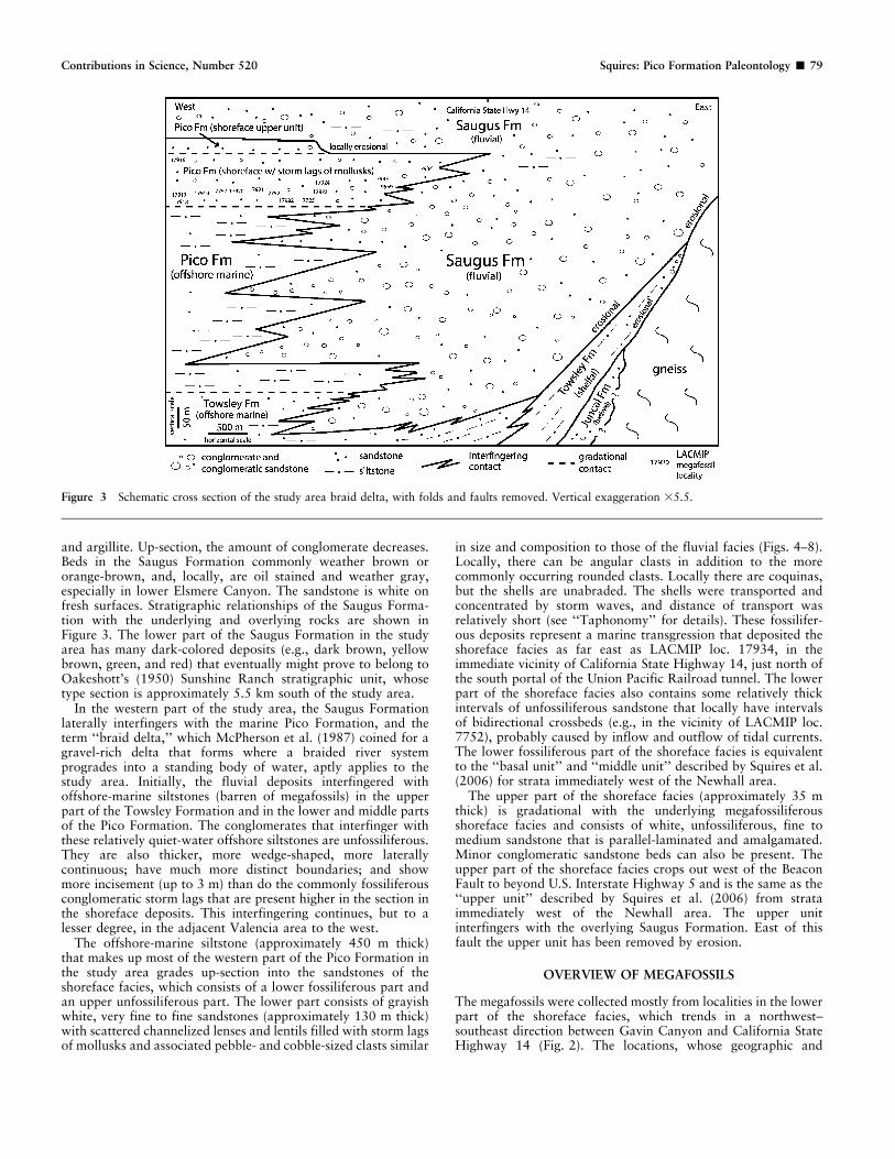
In the western part of the study area, the Saugus Formationlaterally interfingers with the marine Pico Formation, and theterm ‘‘braid delta,’’ which McPherson et al. (1987) coined for agravel-rich delta that forms where a braided river systemprogrades into a standing body of water, aptly applies to thestudy area. Initially, the fluvial deposits interfingered withoffshore-marine siltstones (barren of megafossils) in the upperpart of the Towsley Formation and in the lower and middle partsof the Pico Formation. The conglomerates that interfinger withthese relatively quiet-water offshore siltstones are unfossiliferous.They are also thicker, more wedge-shaped, more laterallycontinuous; have much more distinct boundaries; and showmore incisement (up to 3 m) than do the commonly fossiliferousconglomeratic storm lags that are present higher in the section inthe shoreface deposits. This interfingering continues, but to alesser degree, in the adjacent Valencia area to the west.
The offshore-marine siltstone (approximately 450 m thick)that makes up most of the western part of the Pico Formation inthe study area grades up-section into the sandstones of theshoreface facies, which consists of a lower fossiliferous part andan upper unfossiliferous part. The lower part consists of grayishwhite, very fine to fine sandstones (approximately 130 m thick)with scattered channelized lenses and lentils filled with storm lagsof mollusks and associated pebble- and cobble-sized clasts similar
in size and composition to those of the fluvial facies (Figs. 4–8).Locally, there can be angular clasts in addition to the morecommonly occurring rounded clasts. Locally there are coquinas,but the shells are unabraded. The shells were transported andconcentrated by storm waves, and distance of transport wasrelatively short (see ‘‘Taphonomy’’ for details). These fossilifer-ous deposits represent a marine transgression that deposited theshoreface facies as far east as LACMIP loc. 17934, in theimmediate vicinity of California State Highway 14, just north ofthe south portal of the Union Pacific Railroad tunnel. The lowerpart of the shoreface facies also contains some relatively thickintervals of unfossiliferous sandstone that locally have intervalsof bidirectional crossbeds (e.g., in the vicinity of LACMIP loc.7752), probably caused by inflow and outflow of tidal currents.The lower fossiliferous part of the shoreface facies is equivalentto the ‘‘basal unit’’ and ‘‘middle unit’’ described by Squires et al.(2006) for strata immediately west of the Newhall area.
The upper part of the shoreface facies (approximately 35 mthick) is gradational with the underlying megafossiliferousshoreface facies and consists of white, unfossiliferous, fine tomedium sandstone that is parallel-laminated and amalgamated.Minor conglomeratic sandstone beds can also be present. Theupper part of the shoreface facies crops out west of the BeaconFault to beyond U.S. Interstate Highway 5 and is the same as the‘‘upper unit’’ described by Squires et al. (2006) from strataimmediately west of the Newhall area. The upper unitinterfingers with the overlying Saugus Formation. East of thisfault the upper unit has been removed by erosion.
OVERVIEW OF MEGAFOSSILS
The megafossils were collected mostly from localities in the lowerpart of the shoreface facies, which trends in a northwest–southeast direction between Gavin Canyon and California StateHighway 14 (Fig. 2). The locations, whose geographic and
Figure 3 Schematic cross section of the study area braid delta, with folds and faults removed. Vertical exaggeration 35.5.
Contributions in Science, Number 520 Squires: Pico Formation Paleontology & 79
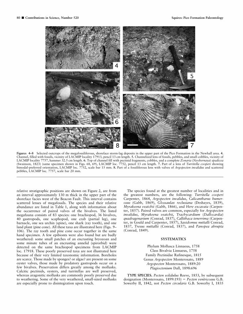
relative stratigraphic positions are shown on Figure 2, are froman interval approximately 130 m thick in the upper part of theshoreface facies west of the Beacon Fault. This interval containsscattered lenses of megafossils. The species and their relativeabundance are listed in Table 1, along with information aboutthe occurrence of paired valves of the bivalves. The listedmegafauna consists of 83 species: one brachiopod, 36 bivalves,40 gastropods, one scaphopod, one crab (partial leg), onebarnacle, one sea urchin (spine), one shark (ray tooth), and oneland plant (pine cone). All these taxa are illustrated here (Figs. 9–106). The ray tooth and pine cone occur together in the samehand specimen. A few epibionts were also found but are badlyweathered: some small patches of an encrusting bryozoan andsome minute tubes of an encrusting annelid (spirorbid) weredetected on the same brachiopod specimens from LACMIPloc. 17918. These poorly preserved taxa are not illustrated herebecause of their very limited taxonomic information. Boreholesare scarce. Those made by sponges? or algae? are present on someoyster valves, those made by predatory gastropods occur on afew bivalves. Preservation differs greatly among the mollusks.Calcitic pectinids, oysters, and turritellas are well preserved,whereas aragonitic mollusks are commonly poorly preserved dueto weathering. Some of the very weathered, small-sized mollusksare especially prone to disintegration upon touch.
The species found at the greatest number of localities and inthe greatest numbers, are the following: Turritella cooperiCarpenter, 1864, Argopecten invalidus, Calicantharus humer-osus (Gabb, 1869), Glossaulax reclusiana (Deshayes, 1839),Myrakeena veatchii (Gabb, 1866), and Here excavata (Carpen-ter, 1857). Paired valves are common, especially for Argopecteninvalidus, Myrakeena veatchii, Trachycardium (Dallocardia)quadragenarium (Conrad, 1837), Callithaca tenerrima (Carpen-ter, in Gould and Carpenter, 1857), Saxidomus nuttalli Conrad,1837, Tresus nuttallii (Conrad, 1837), and Panopea abrupta(Conrad, 1849).
SYSTEMATICS
Phylum Mollusca Linnaeus, 1758Class Bivalvia Linnaeus, 1758
Family Pectinidae Rafinesque, 1815Genus Argopecten Monterosato, 1889
Argopecten Monterosato, 1889:20Plagioctenium Dall, 1898:696
TYPE SPECIES. Pecten solidulus Reeve, 1853, by subsequentdesignation (Monterosato, 1899:193) 5 Pecten ventricosus G.B.Sowerby II, 1842, not Pecten circularis G.B. Sowerby I, 1835
Figures 4–8 Selected outcrops of the megafossiliferous, shoreface storm-lag deposits in the upper part of the Pico Formation in the Newhall area. 4.Channel, filled with fossils, vicinity of LACMIP locality 17913, pencil 13 cm length. 5. Channelized lens of fossils, pebbles, and small cobbles, vicinity ofLACMIP locality 7757, hammer 32.5 cm length. 6. Top of channel fill with pectinid fragments, cobbles, and a complete Zonaria (Neobernaya) spadicea(Swainson, 1823) (same specimen shown in Figs. 68, 69), LACMIP loc. 7752, pencil 13 cm length. 7. Part of a lens of Turritella cooperi showingbimodal-preferred orientation, LACMIP loc. 7752, scale bar 15 mm. 8. Part of a fossiliferous lens with valves of Argopecten invalidus and scatteredpebbles, LACMIP loc. 7757, scale bar 20 mm.
80 & Contributions in Science, Number 520 Squires: Pico Formation Paleontology

(fide Waller, 1995); Holocene, southern California and Gulf ofCalifornia to Peru (Coan et al., 2000:235).
Argopecten invalidus (Hanna, 1924)
Figures 16–19
Pecten (Plagioctenium) cooperi Arnold, 1906:124, pl. 49, figs. 2–4. Not Pecten cooperi Smith, 1903.
Pecten invalidus Hanna, 1924:177, new name for P. cooperiArnold, 1906.
Pecten (Plagioctenium) subdolus Hertlein, 1925:20, pl. 5, figs. 2,4, 7.
Pecten (Plagioctenium) callidus Hertlein, 1925:22, pl. 5, figs. 1,3, 5, 6.
Pecten (Plagioctenium) invalidus Hanna. Jordan and Hertlein,1926:441; Minch et al., 1976:table 15.
Pecten (Aequipecten) purpuratus Lamarck variety subdolusHertlein. Grant and Gale, 1931:211, pl. 5, fig. 1 (west ofSan Fernando Pass).
Pecten (Aequipecten) purpuratus Lamarck variety callidusHertlein. Grant and Gale, 1931:211, pl. 5, fig. 4.
Pecten (Aequipecten) deserti Conrad variety invalidus Hanna.Grant and Gale, 1931:213–214, pl. 5, figs. 5a–c, 6a–c.
Aequipecten callidus (Hertlein). Wilson, 1955:tables 7, 8.Aequipecten subdolus (Hertlein). Wilson, 1955:table 8.Argopecten invalidus (Hanna). Vedder, 1960: table 151.1;
Moore, 1984:B37, pl. 10, fig. 5; Squires et al., 2006:11–12,figs. 15, 16.
Pecten (Argopecten) subdolus Hertlein. Moore, 1968:50, pl. 23,figs. a, b.
Chlamys (Argopecten) callida Hertlein. Hertlein and Grant,1972:198–199, pl. 32, figs. 9, 11.
Chlamys (Argopecten) invalida Hanna. Hertlein and Grant,1972:200–201, pl. 33, figs. 1, 3, 8.
Chlamys (Argopecten) subdola Hertlein. Hertlein and Grant,1972:201–202, pl. 30, figs. 7, 8; pl. 35, figs. 2, 5, 9.
Argopecten subdolus (Hertlein). Moore, 1984:B37–B38, pl. 10,figs. 3, 4.
Argopecten callidus (Hertlein). Moore, 1984:B38–B39, pl. 10,figs. 7, 9.
EMENDED DESCRIPTION. Shell medium size, up to height117 mm; specimens commonly approximately height 45–55 mm.Valves slightly longer than high on most specimens; smallerspecimens tend to be slightly longer than high, larger specimenstend to be slightly higher than long. Left valve more convex thanright valve on most specimens; valves nearly equally convex onfew specimens. Hinge line approximately half of disk length.Umbonal (apical angle) 100u–105u. Ribs 20–22 in number onboth valves, with lamellae in interspaces. Ribs become obsoleteon anteriormost and posteriormost parts of valves and tend toflatten out and become more convex in the later stages ofgrowth. Auricles with prominent radial riblets on both valves;riblets stronger on anterior auricles of both valves. Left valve:ribs narrower than on right valve; interspaces wider than ribsand wider than those on right valve; anterior auricle with verysmall notch; posterior auricle slightly truncated; anterior andposterior auricles, both auricles with seven to nine riblets. Rightvalve: ribs wider than on left valve; interspaces narrower thanribs and narrower than those on left valve; anterior auricle withsmall notch; five to seven flattish riblets, strongest onecoincident with notch area and variable in width and elevation;posterior auricle slightly truncate; six to seven (rarely more)radial riblets.
COMPARISON. Argopecten invalidus, A. callidus, and A.subdolus are conspecific based on a comparative study of actual
specimens of each ‘‘species’’ that shows they lack consistent,reliable morphologic differences separating them from oneanother. Their reported differences (see Hertlein, 1925; Hertleinand Grant, 1972) were based on whether or not the ribs are flat-topped, rounded, and on the depth of the interspaces. Thesedifferences, however, are attributable to how much weatheringthe specimens have experienced. In the study area, for example,specimens of A. invalidus at any one locality show variation inthe shape and depth of the ribs, with the variation clearlyattributable to the degree of weathering.
In addition to A. invalidus, A. callidus, and A. subdolus, Grantand Gale (1931:see pages 210, 211, 212, 214) reported threeother argopectinid species in the study area beds: A. percarus(Hertlein, 1925), A. mendenhalli (Arnold, 1906), and A. imposter(Hanna, 1924). Argopecten percarus differs from A. invalidus byhaving 24–25 ribs on the left valve and an umbonal angle of118u. Argopecten mendenhalli differs from A. invalidus byhaving a much longer hinge line, weak sculpture on the right-valve anterior auricle, obsolete sculpture on the left-valveanterior auricle. Argopecten imposter differs from A. invalidusby having weak grooves along the sides of the major ribs and aleft valve with narrower interspaces.
Argopecten invalidus is similar to A. deserti (Conrad, 1855)and the extant A. ventricosus (G.B. Sowerby II, 1842).Argopecten invalidus differs from A. deserti by having largersize, right-valve interspaces narrower than the ribs, left-valve ribsnarrower than those on the right valve, left-valve interspaceswider than the ribs, more ribs on the right-valve anterior auricle,and a shorter hinge line. Argopecten invalidus differs from A.ventricosus by having a larger maximum height (95 mm), less-inflated right valve, as well as narrower and generally more ribson the right-valve anterior auricle.
In the comparision of the above-mentioned argopectinids, onlythe ribs that extend continuously from the beak to the venterwere counted. Specimens with one or two weak, noncontinuousribs that are present on both the anteriormost and posteriormostsides of the specimens were not included. The largest specimen ofA. invalidus in the study area is 70 mm in height.
TYPE MATERIAL. Holotype of Pecten (Plagioctenium)cooperi Arnold, 1906: CAS 61855.01 [ex CAS/SU 8]; holotypeof Pecten (Plagioctenium) subdolus Hertlein, 1925: CAS61881.01 [ex CAS/SU 51]; holotype of Pecten (Plagioctenium)callidus Hertlein, 1925: CAS 61882.01 [ex CAS/SU 53].
TYPE LOCALITY. Of Pecten (Plagioctenium) cooperi: PacificBeach, San Diego, San Diego County, California; San DiegoFormation, Pliocene. Of Pecten (Plagioctenium) subdolus: CASloc. 61881 [ex SU loc. 115], San Diego County, California; SanDiego Formation, Pliocene. Of Pecten (Plagioctenium) callidus,CAS loc. 61882 [ex SU loc. 116], Cedros Island, Baja California,Mexico, Almejas Formation, Pliocene.
GEOLOGIC AGE. Early to late Pliocene.STRATIGRAPHIC DISTRIBUTION. LOWER PLIOCENE:
Almejas Formation, eastern Cedros Island and Tortugas Bay,Baja California Sur, Mexico (Hertlein, 1925; Jordan andHertlein, 1926; Minch et al., 1976); Tirabuzon Formation[formerly Gloria Formation], Baja California Sur, Mexico(Wilson, 1955). UPPER PLIOCENE: Pico Formation, HolserCanyon area, Los Angeles County, (Grant and Gale, 1931); PicoFormation, northern Simi Valley (especially Las Llajas Canyon),Ventura and Los Angeles counties, California (new information);and Valencia and Newhall areas, northern Los Angeles County,California (Grant and Gale, 1931; Squires et al., 2006; presentreport); Niguel Formation, San Juan Capistrano, Orange County,California (Vedder, 1960); San Diego Formation, lower member,San Diego County, California (Hertlein and Grant, 1972;
Contributions in Science, Number 520 Squires: Pico Formation Paleontology & 81

Figures 9–33 Brachiopod (first figure) and bivalves from upper Pliocene Pico Formation in the Newhall area. All specimens coated with ammoniumchloride. 9. Terebratalia occidentalis (Dall, 1871), hypotype LACMIP 14335, LACMIP loc. 17919, brachial valve, height 32.6 mm, 30.7. 10. Jupiteriataphria (Dall, 1896), hypotype LACMIP 14336, LACMIP loc. 17917, right valve, height 5.7 mm, 33. 11. Arcopsis sp., hypotype LACMIP 14337,LACMIP loc. 17917, partial left valve, height 6.8 mm, 33. 12. Anadara trilineata (Conrad, 1856), hypotype LACMIP 14338, LACMIP loc. 7752, partial
82 & Contributions in Science, Number 520 Squires: Pico Formation Paleontology
Demere, 1983); and Infierno Formation (Wilson, 1955), BajaCaliforna Sur, Mexico.
REMARKS. Argopecten invalidus is one of the most commonmegafossils in the study area, and its preservation is excellent.Specimens range from 3 mm to 67.6 mm in height. Although theycan be weathered, they are unabraded, many have their fragileauricles intact, and many specimens are paired valves (i.e.,Table 1).
Class Gastropoda Cuvier, 1797
Family Calliostomatidae Thiele, 1924
Genus Calliostoma Swainson, 1840
TYPE SPECIES. Trochus conulus Linnaeus, 1758, designatedby Herrmannsen, 1846; Holocene, Mediterranean Sea.
Calliostoma sp., aff. C. grantianum Berry, 1940
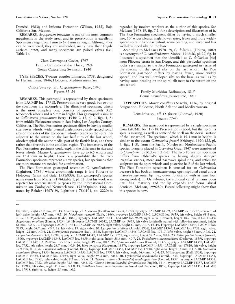
Figures 53–54
REMARKS. This gastropod is represented by three specimensfrom LACMIP loc. 17918. Preservation is very good, but two ofthe specimens are incomplete. The illustrated specimen, whichis the most complete one, consists of approximately 3.25teleoconch whorls and is 5 mm in height. This gastropod is similarto Calliostoma grantianum Berry (1940:12–13, pl. 2, figs. 4, 5)from middle Pleistocene strata in San Pedro, Los Angeles County,California. The Pico Formation specimens differ by having smallersize, fewer whorls, wider pleural angle, more closely spaced spiralribs on the sides of the teleoconch whorls, beads on the spiral ribadjacent to the suture on the last half turn of the last whorl,obsolete spiral ribs on the medial part of the flattish base, and threerather than five ribs in the umbilical region. The immaturity of thePico Formation specimens could explain the difference in size andfewer whorls. Mature C. grantianum have up to 6.5 whorls andare 15.4 mm in height. There is a possibility that the PicoFormation specimens represent a new species, but specimens thatare more mature are needed for confirmation.
The Pico Formation gastropod resembles C. canaliculatum(Lightfoot, 1786), whose chronologic range is late Pliocene toHolocene (Grant and Gale, 1931:833). This gastropod9s speciesname stems from Martyn (1784:table 1, pl. 32), but his work wasrejected for nomenclatural purposes by the International Com-mission on Zoological Nomenclature (1957:Opinion 456). Asnoted by Rehder (1967:19), Lightfoot (1786:101, no. 2220) is
regarded by modern workers as the author of this species. SeeMcLean (1978:19, fig. 7.2) for a description and illustration of it.The Pico Formation specimens differ by having a much smallersize, 10u wider pleural angle, lower spire, fewer and more widelyspaced spiral ribs on last whorl, some beading, and fewer and lesswell-developed ribs on the base.
According to McLean (1978:19), C. dolarium (Holten, 1802)is a synonym of C. canaliculatum. Moore (1968:56, pl. 27, fig. b)illustrated a specimen that she identified as C. doliarium [sic]from Pliocene strata in San Diego, and this particular specimenlooks very similar to the Pico Formation gastropod in terms ofthe spacing of the spiral ribs on the last whorl. The PicoFormation gastropod differs by having fewer, more widelyspaced, and less well-developed ribs on the base, as well as byhaving some beading on the spiral rib next to the suture on thelast whorl.
Family Muricidae Rafinesque, 1815
Genus Ocinebrina Jousseaume, 1880
TYPE SPECIES. Murex corallinus Scacchi, 1836, by originaldesignation; Holocene, North Atlantic and Mediterranean.
Ocinebrina sp., aff. O. fraseri (Oldroyd, 1920)
Figures 77–79
REMARKS. This gastropod is represented by a single specimenfrom LACMIP loc. 17918. Preservation is good, but the tip of itsspire is missing, as well as some of the shell on the dorsal surfaceof the last whorl. The specimen, which is 19.3 mm in height, issimilar to the extant Ocinebrina fraseri (Oldroyd, 1920:135, pl.4, figs. 1–3), from the Pacific Northwest. Northeastern Pacificspecies formerly placed in Ocenebra Gray, 1847 were transferredto Ocinebrina by McLean (1996). The Pico Formation specimendiffers from Oldroyd’s species by having slightly strongerirregular varices, more and narrower spiral ribs, and reticulatesculpture on the spire whorls and posterior half of the last whorl.The Pico Formation specimen is unusual for an Ocinebrinabecause it has both an immature-stage open siphonal canal and amature-stage outer lip (i.e., outer lip interior with at least fourstrong nodes). In Ocinebrina, the siphonal canal remains openuntil final maturity and the lip expands and forms labrialdenticles (McLean, 1996:80). Future collecting might show thatthis species is new.
r
left valve, height 23.2 mm, 31. 13. Limaria sp., cf. L. orcutii (Hertlein and Grant, 1972), hypotype LACMIP 14339, LACMIP loc. 17917, steinkern ofleft? valve, height 45.7 mm, 30.5. 14. Myrakeena veatchii (Gabb, 1866), hypotype LACMIP 14340, LACMIP loc. 9659, left valve, height 68.8 mm,30.5. 15. Myrakeena veatchii (Gabb, 1866), hypotype LACMIP 14341, LACMIP loc. 9659, right valve (juvenile), height 18.2 mm, 31.2. 16–19.Argopecten invalidus (Hanna, 1924). 16. Hypotype LACMIP 14342, LACMIP loc. 9659, left valve (originally paired with following specimen), height61 mm, 30.7. 17. Hypotype LACMIP 14343, LACMIP loc. 9659, right valve, height 60 mm, 30.7. 18–19. Hypotype LACMIP 14344, LACMIP loc.9659, height 66.7 mm, 30.7. 18. left valve. 19. right valve. 20. Lyropecten catalinae (Arnold, 1906), LACMIP 14345, LACMIP loc. 7752, right valve,height 122 mm, 30.4. 21. Swiftopecten parmeleei (Dall, 1898), hypotype LACMIP 14346, LACMIP loc. 17917, left? valve, height 53 mm, 30.6. 22.Leopecten stearnsii (Dall, 1878), hypotype LACMIP 14347, LACMIP loc. 7752, right valve, height 57.2 mm, 30.6. 23. Patinopecten healeyi (Arnold,1906), hypotype LACMIP 14348, LACMIP loc. 9659, right valve, height 58.6 mm, 30.7. 24. Pododesmus macroschisma (Deshayes, 1839), hypotypeLACMIP 14349, LACMIP loc. 17917, left valve, height 49 mm, 30.5. 25. Epilucina californica (Conrad, 1837), hypotype LACMIP 14350, LACMIPloc. 7752, left valve, height 26.7 mm, 30.9. 26. Here excavata (Carpenter, 1857), hypotype LACMIP 14351, LACMIP loc. 17920, left valve, height17.9 mm, 31.2. 27. Lucinisca nuttalli (Conrad, 1837), hypotype LACMIP 14352, LACMIP loc. 17918, right valve, height 14 mm, 31.7. 28. Lucinomaannulatum (Reeve, 1850), hypotype LACMIP 14353, LACMIP loc. 17917, left valve, height 56.4 mm, 30.4. 29. Miltha xantusi (Dall, 1905), hypotypeLACMIP 14354, LACMIP loc. 17934, right valve, height 98.3 mm, 30.2. 30. Cyclocardia occidentalis Conrad, 1855, hypotype LACMIP 14355,LACMIP loc. 7752, right valve, height 8.2 mm, 32.6. 31. Trachycardium (Dallocardia) quadragenarium (Conrad, 1837), hypotype LACMIP 14356,LACMIP loc. 7752, left valve, height 73.3 mm, 30.4. 32. Chione (Anomalocardia) fernandoensis English, 1914, hypotype LACMIP 14357, LACMIPloc. 17918, left valve, height 11.2 mm, 31.8. 33. Callithaca tenerrima (Carpenter, in Gould and Carpenter, 1857), hypotype LACMIP 14358, LACMIPloc. 17918, right valve, height 85 mm, 30.2.
Contributions in Science, Number 520 Squires: Pico Formation Paleontology & 83

Figures 34–72 Bivalves and gastropods from upper Pliocene Pico Formation in the Newhall area. All specimens coated with ammonium chloride. 34.Compsomyax subdiaphana (Carpenter, 1864), hypotype LACMIP 14359, LACMIP loc. 7757, right valve, height 30.6 mm, 307. 35. Amiantis callosa(Conrad, 1837), hypotype LACMIP 14360, LACMIP loc. 7752, left valve, height 47.5 mm, 30.5. 36. Dosinia ponderosa (Gray, 1838), hypotypeLACMIP 14362, LACMIP loc. 7725, left valve, height 101.7 mm, 30.3. 37. Saxidomus nuttalli Conrad, 1837, hypotype LACMIP 14361, LACMIP loc.
84 & Contributions in Science, Number 520 Squires: Pico Formation Paleontology
DISCUSSION
AGE
The chronologic ranges of the Newhall-area species that have theshortest ranges are depicted in Figure 107. Based on overlap ofthese ranges, these species indicate a late Pliocene age, which is inagreement with the age reported by Squires et al. (2006) for thePico Formation in the Valencia area. Their age was based onmollusks and benthic foraminifera, as well as on paleomagne-tic studies of the overlying Saugus Formation. Squires et al.(2006:fig. 23) provided a diagram showing the chronostrati-graphic framework for the Pliocene and Pleistocene and includedmagnetostratigraphy and various biostratigraphic zones/stages.Their figure, however, is out of date in terms of the age of thebase of the Pleistocene. In 2009, the International Commissionon Stratigraphy (see Gibbard et al., 2009) reported that thePliocene ranges from 5.33 to 2.58 Ma. The ‘‘early Pliocene’’(Zanciean Stage) ranges from 5.33 to 3.6 Ma, and the ‘‘latePliocene’’ (Piacenzian Stage) ranges from 3.6 to 2.58 Ma. The‘‘middle Pliocene’’ is no longer recognized.
A late Pliocene age for the Pico Formation in the Newhall areacontradicts a latest Miocene to earliest Pliocene age (5.5 6
0.4 Ma) reported by Berry et al. (2009:fig. 4) based on strontium-isotope studies of fragments of oyster and pectinid shells fromGavin Canyon. Weathered shells might account for the contra-dictory age report.
Presence of the gastropods Cancellaria hamlini Carson, 1926and Rictaxis painei grandior Grant and Gale (1931) in theNewhall area Pico Formation refines their poorly known geologicage. Carson (1926:51) reported C. hamlini only from strata ofearly Pliocene age in Elsmere Canyon, but Kern (1973), in hisdetailed study of the fauna there, did not detect this species.Grant and Gale (1931:444) reported R. p. grandior only fromundifferentiated Pliocene strata in Holser Canyon near ValVerde, Ventura County, California. These strata are part of an
almost continuous section of Pico Formation that extends fromNewhall Pass to Holser Canyon (Grant and Gale, 1931:33). Inconclusion, the geologic age of both of these gastropods is latePliocene.
The taxonomic composition of the megafauna of the PicoFormation in the Newhall area and adjacent Valencia area ismost similar to the upper Pliocene Niguel Formation at SanJuan Capistrano, Orange County, California (see Vedder, 1960;Stadum, 1984) and to the upper Pliocene lower member of theSan Diego Formation, San Diego County, California (seeDemere, 1983). There is also similarity to the megafauna of theupper Pliocene Cebada and Craciosa members of the CareagaSandstone, Santa Maria, Santa Barbara County (see Woodringand Bramlette, 1950).
DEPTH
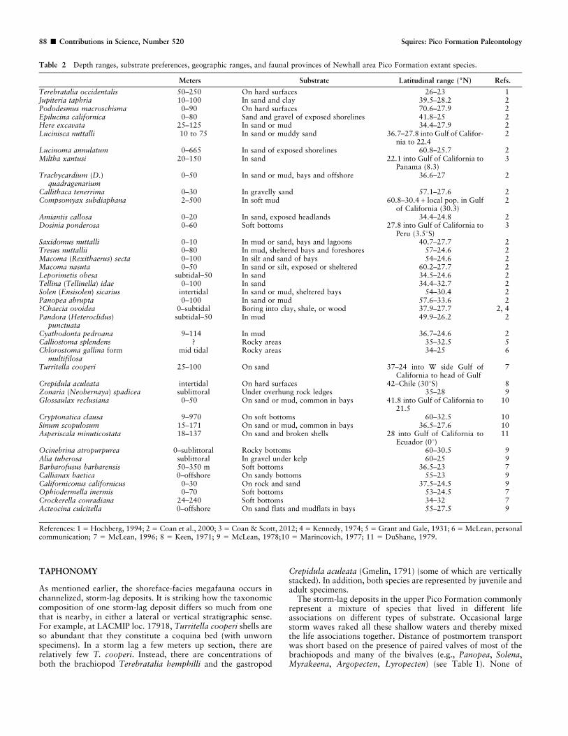
Table 2 provides the depth-range data for the 41 extant speciesfound in the Newhall area; the average depth range of thesespecies is 8 to 144 m. Using Valentine’s (1961:fig. 2) diagram ofthe classification of marine environments, the Newhall-areamegafauna lived predominantly in the inner sublittoral marineenvironment.
Winterer and Durham (1962) reported that based on benthicforaminifera, the marine facies on the north side of GavinCanyon shallowed up-section. The extant Epistominella pacifica(Cushman, 1927) is especially common in beds referred here tothe quiet-water, offshore-marine braid-delta siltstones of the PicoFormation. They reported that this species lives in waters thatrange in depth from 7 to 70 m. Up-section, in the lower part ofthe overlying shoreface sandstone, they found sparse benthicforaminifera, with the extant Nonion scaphum (Fichtel and Moll,1798) as the best-represented species. They reported that thisspecies lives in waters that range in depth from intertidal to 16 m.They found no benthic foraminifera in the stratigraphicallyhigher deposits in the Pico Formation.
r
17921, right valve, height 89.7 mm, 30.3. 38. Tresus nuttallii (Conrad, 1837), hypotype LACMIP 14370, LACMIP loc. 17918, right valve, height60 mm, 30.4. 39. Macoma (Rexithaerus) secta (Conrad, 1837), hypotype LACMIP 14364, LACMIP loc. 7752, left valve, height 54.5 mm, 30.4. 40.Macoma nasuta (Conrad, 1837), hypotype LACMIP 14365, LACMIP loc.17916, right valve, height 49.4 mm, 30.4. 41. Leporimetis obesa (Deshayes,1855), hypotype LACMIP 14366, LACMIP loc. 17921, right valve, height 33.3 mm, 30.7. 42. Tellina (Tellinella) idae Dall, 1891, hypotype LACMIP14363, LACMIP loc. 17920, external mold of right valve, height 24.3 mm, 30.7. 43. Gari sp., hypotype LACMIP 14367, LACMIP loc. 7757, internalmold of partial left valve, height 62.4 mm, 30.3. 44. Solen (Ensisolen) sicarius Gould, 1850, hypotype LACMIP 14368, LACMIP loc. 17917, left? valve,height 10.5 mm, 30.6. 45. Solen sp., cf. S. perrini Clark, 1915, hypotype LACMIP 14369, LACMIP loc. 17917, right? valve, height 32.6 mm, 30.3. 46.Panopea abrupta (Conrad, 1849), hypotype LACMIP 14371, LACMIP loc. 17917, left valve, height 65.6 mm, 30.3. 47. ?Chaceia ovoidea (Gould,1851), hypotype LACMIP 14372, LACMIP loc. 7757, right valve, height 42.9 mm, 30.4. 48. Pandora (Heteroclidus) punctuata Conrad, 1837, hypotypeLACMIP 14373, LACMIP loc. 7757, right-valve interior, height 10.1 mm, 31.6. 49. ?Cyathodonta pedroana Dall, 1915, hypotype LACMIP 14374,LACMIP loc. 7757, partial right valve, height 47.7 mm, 30.5. 50. Haliotis sp., hypotype LACMIP 14375, LACMIP loc. 17921, partial specimen, longestdimension 57 mm, 30.33. 51–52. Calliostoma sp., cf. splendens Carpenter, 1864, hypotype LACMIP 14376, LACMIP loc. 17918, height 6.7 mm, 33.3.51. apertural view. 52. umbilical view. 53–54. Calliostoma sp., aff. C. grantianum Berry, 1940, hypotype LACMIP 14377, LACMIP loc. 17918, height5 mm, 34.2. 53. apertural view. 54. umbilical view. 55–56. Chlorostoma gallina form multifilosa Stearns, 1892, hypotype LACMIP 14378, LACMIPloc. 7753, height 15.8 mm, 31.4. 55. apertural view. 56. umbilical view. 57–58. Homoploma paucicostatum? (Dall, 1871), hypotype LACMIP 14379,LACMIP loc. 17918, height 5.9 mm, 34. 57. apertural view. 58. ventral view. 59–60. Pomaulax gradata Grant and Gale, 1931, hypotype LACMIP14380, LACMIP loc. 7752, height 36.4 mm, 30.6. 59. apertural view. 60. umbilical view. 61. Operculum of ?Pomaulax gradata Grant and Gale, 1931,hypotype LACMIP 14381, LACMIP loc. 7752, interior view, longest dimension 17.5 mm, 31.3. 62. Lirobittium asperum (Gabb, 1861), hypotypeLACMIP 14382, LACMIP loc. 17918, apertural view of partial specimen, height 5.5 mm, 34.8. 63. Turritella cooperi Carpenter, 1864, hypotypeLACMIP 14383, LACMIP loc. 17917, apertural view, height 31.8, 31. 64. ?Calyptraea (Trochita) sp., hypotype LACMIP 14384, LACMIP loc. 17918,dorsal view, diameter 7.5 mm, 33. 65–66. Crepidula aculeata (Gmelin, 1791), LACMIP loc. 17918. 65. Hypotype LACMIP 14385, dorsal view, height16.7 mm, 31.4. 66. hypotype LACMIP 14386, two specimens vertically stacked, total height 26.9 mm, 30.5. 67. Grandicrepidula princeps (Conrad,1857), hypotype LACMIP 14387, LACMIP loc. 17921, dorsal view, height 56.4, 30.5. 68–69. Zonaria (Neobernaya) spadicea (Swainson, 1823),hypotype LACMIP 14388, LACMIP loc. 7752, height 40.1 mm, 30.6. 68. Apertural view. 69. dorsal view. 70. Glossaulax reclusiana (Deshayes, 1839),hypotype LACMIP 14389, LACMIP loc. 7752, apertural view, height 46.7 mm, 30.5. 71. Cryptonatica clausa (Broderip and Sowerby, 1829), hypotypeLACMIP 14390, LACMIP loc. 7752, apertural view, height 9.6 mm, 32.4. 72. Sinum scopulosum (Conrad, 1849), hypotype LACMIP 14391, LACMIPloc. 7757, abapertural view, height 19.6 mm, 30.8.
Contributions in Science, Number 520 Squires: Pico Formation Paleontology & 85
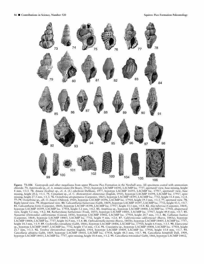
Figures 73–106 Gastropods and other megafauna from upper Pliocene Pico Formation in the Newhall area. All specimens coated with ammoniumchloride. 73. Asperiscala sp., cf. A. minuticostata (De Boury, 1912), hypotype LACMIP 14392, LACMIP loc. 7757, apertural? view, base missing, height8 mm, 33.3. 74. Amaea (Scalina) sp., cf. A. (S.) edwilsoni DuShane, 1977, hypotype LACMIP 14393, LACMIP loc. 17917, apertural? view, basemissing, height 20.2, 31.1. 75. Cymatium sp., cf. C. (Reticutriton) elsmerense (English, 1914), hypotype LACMIP 14394, LACMIP loc. 17917, spiremissing, height 27.5 mm, 31.3. 76. Ocinebrina atropurpurea (Carpenter, 1865), hypotype LACMIP 14395, LACMIP loc. 7752, height 11.4 mm, 32.4.77–79. Ocinebrina sp., aff. O. fraseri (Oldroyd, 1920), hypotype LACMIP 14396, LACMIP loc. 17918, height 19.3 mm, 31.3. 77. apertural view. 78.Right-lateral view. 79. Abapertural view. 80. Calicantharus humerosus (Gabb, 1869), hypotype LACMIP 14397, LACMIP loc. 7752, height 43.5, 30.7.81. Calicantharus fortis (Carpenter, 1864), hypotype LACMP 14398, LACMIP loc. 17917, height 33.1 mm, 30.8. 82. Alia tuberosa (Carpenter, 1864),hypotype LACMIP 14399, LACMIP loc. 17918, height 5.2 mm, 34.2. 83. Amphissa sp., hypotype LACMIP 14400, LACMIP loc. 17918, abaperturalview, height 5.2 mm, 34.2. 84. Barbarofusus barbarensis (Trask, 1855), hypotype LACMIP 14401, LACMIP loc. 17917, height 49.4 mm, 30.7. 85.Nassarius (Demondia) californianus (Conrad, 1856), hypotype LACMIP 14402, LACMIP loc. 17918, height 20.7 mm, 31.3. 86. Callianax baetica(Carpenter, 1864), hypotype LACMIP 14403, LACMIP loc. 7752, height 9 mm, 32.6. 87. Californiconus californicus? (Reeve, 1843a), hypotypeLACMIP 14404, LACMIP loc. 7757, height 16.9 mm, 31.4. 88. Ophiodermella inermis (Reeve, 1843b), hypotype LACMIP 14405, LACMIP loc. 7757,height 14.3 mm, 31.9. 89. Cockerella conradiana (Gabb, 1866), hypotype LACMIP 14406, LACMIP loc. 17918, height 6.4 mm, 33.5. 90. Elaeocymasp., hypotype LACMIP 14407, LACMIP loc. 7752, height 17.6 mm, 31.6. 91. Crassispira sp., hypotype LACMIP 14408, LACMIP loc. 17918, height21.7 mm, 31.3. 92. Terebra (Strioterebra) martini English, 1914, hypotype LACMIP 14409, LACMIP loc. 17918, height 15.8 mm, 31.7. 93.Cancellaria altispira Gabb, 1869, hypotype LACMIP 14410, LACMIP loc. 17934, height 44.3 mm, 30.7. 94. Cancellaria hemphilli Dall, 1909,hypotype LACMIP 14411, LACMIP loc. 7757, spire missing, height 18.4 mm, 31.2. 95. Cancellaria tritonidea? Gabb, 1866, hypotype LACMIP 14412,
86 & Contributions in Science, Number 520 Squires: Pico Formation Paleontology

SUBSTRATE
At least three substrate types are recognized for the study areadeposits: fine-grained offshore sediments, fine- to medium-grainedsandy deltaic sediments, and hard surfaces. The first type waslocated immediately seaward of the delta and essentially fringedthe delta; the second occurred on the delta complex itself; and thethird occurred in association with coarse debris on the delta. Thepresence of fine-grained offshore substrate is indicated by the veryabundant gastropod Turritella cooperi. Valentine and Mallory(1965) assigned this species to their Group III Pleistocene offshorefossil community, along with the bivalve Lucinoma annulatum(Reeve, 1850), another megafaunal element, but a rare one, of theNewhall Pico Formation assemblages. Although details are lackingabout how T. cooperi lives, it is probably like most species ofextant Turritella. Bandel (1976) reported that Turritella variegata(Linnaeus, 1758) from the Caribbean coast of Colombia lives as asuspension feeder shallowly buried in soft substrates. Largepopulations migrate only at the time of spawning once a year,and they crawl to more sandy bottoms or bottom covered withgravel where they can attach their spawn more firmly in coarsedebris than is possible in muddy environments. Allmon et al.(1992) reported that Turritella gonostoma Valenciennes, 1832,from the northern Gulf of California lives in depths less than 5 mand, in the winter, migrates into shallow water to reach nutrient-rich waters and to lay its eggs. It seems very likely that thespecimens of T. cooperi that dominate the fossil assemblages at
most localities in the Newhall area preferred to live in closeproximity to a river delta because the river would deliver nutrientson which it feeds. During the winter, individuals could migrate,from silty substrate to shallower water and sandy and gravellysubstrates, in order to lay their eggs.
The fine- to medium-grained sandy delta substrate is indicatedby paired-valved epifaunal bivalves (e.g., Argopecten, Lyropec-ten, Patinopecten), epifaunal gastropods (e.g., Glossaulax,Conus), and paired-valved infaunal bivalves (e.g., Trachycar-dium, Saxidomus, Tresus, Panopea). Hard-surface biotopes werevery localized. The Haliotis specimen and the Terebrataliaoccidentalis brachiopods most likely attached to shell debris orlarger rock clasts. The latter, in a few cases, provided hardsubstrate for encrusting bryozoan and spirorbid tubes. Someindividuals of the plicate oyster Myrakeena veatchii livedattached to each other, based on a cluster of specimens foundattached to each other at LACMIP loc. 9659, where a growthseries of this oyster was also found. The occurrence of the paired-valved single specimen of the pholadid ?Chaecia ovoidea (Gould,1851) is anomalous because this species normally bores into clayor shale (Coan et al., 2000). Kennedy (1974:39) reported that C.ovoidea has been known to bore into waterlogged wood, and thiscould explain its presence in the study area megafauna.
The above-mentioned three types of substrate are compatiblewith the findings derived from Table 2 showing that the majorityof the 41 extant species of the Pico Formation megafauna live in/on sand or mud; only a few live on hard surfaces (Table 2).
r
LACMIP loc. 7752, height 23.8 mm, 30.9. 96. Cancellaria hamlini Carson, 1926, hypotype LACMIP 14413, LACMIP loc. 17919, height 21.5 mm,30.9. 97. Turbonilla sp., hypotype LACMIP 14414, LACMIP loc. 17918, upper spire missing, height 6 mm, 33.1. 98. Rictaxis painei grandior Grantand Gale, 1931, hypotype LACMIP 14415, LACMIP loc. 7752, height 13.3 mm, 31.7. 99. Acteocina culcitella? (Gould, 1853), hypotype LACMIP14416, LACMIP loc. 7760, height 3 mm, 37.5. 100–101. Scaphopod Dentalium neohexagonum Sharp and Pilsbry, in Pilsbry and Sharp, 1897, LACMIPloc. 7752. 100. Hypotype LACMIP 14417, height 9.8 mm, 32.4. 101. Hypotype LACMIP 14418, diameter 2.3 mm, 33.7. 102. Barnacle Balanus? sp.,hypotype LACMIP 14419, LACMIP loc. 17917, side view, height 5.5 mm, 32. 103. Crab leg (partial), hypotype LACMIP 14420, LACMIP loc. 17918,height 10.2 mm, 32.2. 104. Echinoid spine Eucidaris sp., hypotype LACMIP 144421, LACMIP loc. 17917, height 4.2, 35.4. 105. Ray tooth Myliobatissp., hypotype LACMIP 14422, LACMIP loc. 7752, maximum dimension 25 mm, 30.9. 106. Pine cone, hypotype LACMIP 14423, LACMIP loc. 7752,cross-section, height 50 mm, 30.6.
Figure 107 Chronostratigraphic distribution of the study area species with the most constrained geologic ranges indicating a late Pliocene age.
Contributions in Science, Number 520 Squires: Pico Formation Paleontology & 87
TAPHONOMY
As mentioned earlier, the shoreface-facies megafauna occurs inchannelized, storm-lag deposits. It is striking how the taxonomiccomposition of one storm-lag deposit differs so much from onethat is nearby, in either a lateral or vertical stratigraphic sense.For example, at LACMIP loc. 17918, Turritella cooperi shells areso abundant that they constitute a coquina bed (with unwornspecimens). In a storm lag a few meters up section, there arerelatively few T. cooperi. Instead, there are concentrations ofboth the brachiopod Terebratalia hemphilli and the gastropod
Crepidula aculeata (Gmelin, 1791) (some of which are verticallystacked). In addition, both species are represented by juvenile andadult specimens.
The storm-lag deposits in the upper Pico Formation commonlyrepresent a mixture of species that lived in different lifeassociations on different types of substrate. Occasional largestorm waves raked all these shallow waters and thereby mixedthe life associations together. Distance of postmortem transportwas short based on the presence of paired valves of most of thebrachiopods and many of the bivalves (e.g., Panopea, Solena,Myrakeena, Argopecten, Lyropecten) (see Table 1). None of
Table 2 Depth ranges, substrate preferences, geographic ranges, and faunal provinces of Newhall area Pico Formation extant species.
Meters Substrate Latitudinal range (6N) Refs.
Terebratalia occidentalis 50–250 On hard surfaces 26–23 1Jupiteria taphria 10–100 In sand and clay 39.5–28.2 2Pododesmus macroschisma 0–90 On hard surfaces 70.6–27.9 2Epilucina californica 0–80 Sand and gravel of exposed shorelines 41.8–25 2Here excavata 25–125 In sand or mud 34.4–27.9 2Lucinisca nuttalli 10 to 75 In sand or muddy sand 36.7–27.8 into Gulf of Califor-
nia to 22.42
Lucinoma annulatum 0–665 In sand of exposed shorelines 60.8–25.7 2Miltha xantusi 20–150 In sand 22.1 into Gulf of California to
Panama (8.3)3
Trachycardium (D.)quadragenarium
0–50 In sand or mud, bays and offshore 36.6–27 2
Callithaca tenerrima 0–30 In gravelly sand 57.1–27.6 2Compsomyax subdiaphana 2–500 In soft mud 60.8–30.4 + local pop. in Gulf
of California (30.3)2
Amiantis callosa 0–20 In sand, exposed headlands 34.4–24.8 2Dosinia ponderosa 0–60 Soft bottoms 27.8 into Gulf of California to
Peru (3.5uS)3
Saxidomus nuttalli 0–10 In mud or sand, bays and lagoons 40.7–27.7 2Tresus nuttallii 0–80 In mud, sheltered bays and foreshores 57–24.6 2Macoma (Rexithaerus) secta 0–100 In silt and sand of bays 54–24.6 2Macoma nasuta 0–50 In sand or silt, exposed or sheltered 60.2–27.7 2Leporimetis obesa subtidal–50 In sand 34.5–24.6 2Tellina (Tellinella) idae 0–100 In sand 34.4–32.7 2Solen (Ensisolen) sicarius intertidal In sand or mud, sheltered bays 54–30.4 2Panopea abrupta 0–100 In sand or mud 57.6–33.6 2?Chaecia ovoidea 0–subtidal Boring into clay, shale, or wood 37.9–27.7 2, 4Pandora (Heteroclidus)
punctuatasubtidal–50 In mud 49.9–26.2 2
Cyathodonta pedroana 9–114 In mud 36.7–24.6 2Calliostoma splendens ? Rocky areas 35–32.5 5Chlorostoma gallina form
multifilosamid tidal Rocky areas 34–25 6
Turritella cooperi 25–100 On sand 37–24 into W side Gulf ofCalifornia to head of Gulf
7
Crepidula aculeata intertidal On hard surfaces 42–Chile (30uS) 8Zonaria (Neobernaya) spadicea sublittoral Under overhung rock ledges 35–28 9Glossaulax reclusiana 0–50 On sand or mud, common in bays 41.8 into Gulf of California to
21.510
Cryptonatica clausa 9–970 On soft bottoms 60–32.5 10Sinum scopulosum 15–171 On sand or mud, common in bays 36.5–27.6 10Asperiscala minuticostata 18–137 On sand and broken shells 28 into Gulf of California to
Ecuador (0u)11
Ocinebrina atropurpurea 0–sublittoral Rocky bottoms 60–30.5 9Alia tuberosa sublittoral In gravel under kelp 60–25 9Barbarofusus barbarensis 50–350 m Soft bottoms 36.5–23 7Callianax baetica 0–offshore On sandy bottoms 55–23 9Californiconus californicus 0–30 On rock and sand 37.5–24.5 9Ophiodermella inermis 0–70 Soft bottoms 53–24.5 7Crockerella conradiana 24–240 Soft bottoms 34–32 7Acteocina culcitella 0–offshore On sand flats and mudflats in bays 55–27.5 9
References: 1 5 Hochberg, 1994; 2 5 Coan et al., 2000; 3 5 Coan & Scott, 2012; 4 5 Kennedy, 1974; 5 5 Grant and Gale, 1931; 6 5 McLean, personalcommunication; 7 5 McLean, 1996; 8 5 Keen, 1971; 9 5 McLean, 1978;10 5 Marincovich, 1977; 11 5 DuShane, 1979.
88 & Contributions in Science, Number 520 Squires: Pico Formation Paleontology

these infaunal bivalves were found in their burrows. Thesespecimens were displaced from their burrows and transportedwhile alive. Additional evidence of short distance of transport isbased a scarcity of any obvious signs of abrasion. Some examplesare fragile protoconchs of some specimens of Calliostoma sp., aff.C. grantianum (Fig. 53), Nassarius (Demondia) californianus(Conrad, 1856) and Cancellaria hamlini Carson, 1926 (Fig. 96);delicate apical tips of many Turritella cooperi; delicate auricles ofthe pectinids, including those of juvenile Argopecten invalidus;thin varices of Asperiscala minuticostata? (De Boury, 1921); andfour sets of two vertically stacked specimens of Crepidulaaculeata at LACMIP loc. 17918. This is the first report ofvertical stacking of this species. An additional indicator of shortdistance of transport is the presence, at LACMIP loc. 9659, of agrowth series of the oyster Myrakeena veatchii. Specimens rangefrom 18.5 to 85 mm in height. The smallest specimen isillustrated (Fig. 15) because no juvenile specimen of this specieshas ever been illustrated.
Some of the lentils in the upper Pico Formation storm depositsconsist of dense concentrations of unworn, small-sized, mostlydisarticulated specimens of bivalves. There are also a few lensescontaining abundant Turritella cooperi that show preferred
bimodal distribution (Fig. 8) in the way their shells were orientedby shallow-marine wave movements. Occasional large stormwaves, which would be more common during the winter, wouldmove and concentrate the copious Turritella shells, as well asother offshore shells, in storm-lag deposits on the shoaling partsof the braid delta.
ZOOGEOGRAPHIC IMPLICATIONS
Squires et al. (2006) reported that the Pico Formation megafaunain the Valencia area just west of the Newhall area is mostlyindicative of warm-temperate conditions, with a few speciesindicative of warmer conditions. This present study corroboratesthese findings. Table 2 lists the latitudinal ranges of all the extantspecies found in the Pico Formation in the Newhall area, andFigure 108 shows that the zone of maximum overlap ofrepresentative extant species from this list is between 33.5uNand 31uN. This zone plots within the ‘‘Californian’’ molluscanprovince of Valentine (1966) and the warm-temperate, marine-climate zone of Hall (1964). There is, however, a warmer watercomponent (tropical) based on the presence of two extant speciesfound today considerably south of maximum overlap zone:
Figure 108 Latitudinal distribution of selected mollusks (see Table 2 for details) from the upper part of the Pico Formation, Newhall area vs. modernmolluscan provinces and marine climates. Dashed box shows zone of maximum overlap of mollusk distributions at 31uN to 33.5uN. Solid circle 5latitude of the study area (34u219N).
Contributions in Science, Number 520 Squires: Pico Formation Paleontology & 89
Miltha xantusi (Dall, 1905) and Dosinia ponderosa (Gray, 1838)live in the southern (tropical) part of the Gulf of California, aswell as much farther south (see Table 2 for references).
Two of the extinct mollusks from the Newhall area are warm-water indicators found only in fossil deposits of SouthernCalifornia and Baja California, Mexico. They are Argopecteninvalidus and Lyropecten catalinae (Arnold, 1906) [5 Lyropec-ten gallegosi (Jordan and Hertlein, 1926)]. Both are known(Minch et al., 1976) from as far south as the Pliocene AlmejasFormation just south of Bahia Tortugas on the VizcainoPeninsula, Baja California Sur, Mexico.
Another pectinid, Patinopecten healeyi (Arnold, 1906) whichis present at most of the localities in the study area, is alsosignificant in the interpretation of Neogene zoogeography. Thisspecies, like Lyropecten catalinae, is a giant pectinid (seeAddicott, 1974), because of having a size commonly greaterthan 90 mm. Patinopecten healeyi has an early to late Pliocenechronologic range (e.g., Addicott, 1974; Moore, 1979). Itreached its northernmost occurrence (Cape Mendocino innorthern California), but during the late Pliocene, the speciesranged farther south, with its southernmost occurrence in theAlmejas Formation in Baja California Sur (Moore, 1979:fig. 1)),along with the warm-water species Argopecten invalidus and L.catalinae.
The extinct epitoniid gastropod Amaea (Scalina) edwilsoniDuShane, 1977, tentatively identified from the Newhall area, hasbeen reported (DuShane, 1977) only from the Pliocene TirabuzonFormation [formerly Gloria Formation] (Wilson, 1955) nearSanta Rosalia on the Gulf of California, Baja Sur, Mexico.
ACKNOWLEDGMENTS
This study would have been greatly diminished in its scope without thepermission granted to me by the various land owners for access to theirproperty west of California State Highway 14. James H. McLean (LACMMalacology) shared his knowledge of vetigastropods, muricids, andturrids. Lindsey T. Groves (LACM Malacology) provided access todifficult-to-find literature and shared his knowledge of Pliocene mollusks.Brian J. Swanson, Pamela J. Irvine, and Jerome Treiman (all associatedwith the California Geological Survey, Los Angeles), shared theirknowledge of the Saugus Formation. Charles L. Powell, II (USGS, MenloPark) shared his knowledge of the fossils from Gold Creek in Big TujungaCanyon. The manuscript benefited considerably from critical reviews byL.T. Groves and C.L. Powell II.
LITERATURE CITED
Addicott, W.O. 1965. Some western American Cenozoic gastropods ofthe genus Nassarius. United States Geological Survey ProfessionalPaper 503-B:1–21.
———. 1974. Giant pectinids of the eastern north Pacific margin:Significance in Neogene zoogeography and chronostratigraphy.Journal of Paleontology 48(1):180–194.
Allmon, W.A., D.S. Jones, and N. Vaughan. 1992. Observations on thebiology of Turritella gonostoma Valenciennes (Prosobranchia:Turritellidae) from the Gulf of California. The Veliger 35(1):52–63.
Arnold, R. 1903. The paleontology and stratigraphy of the marinePliocene and Pleistocene of San Pedro, California. Memoirs of theCalifornia Academy of Sciences 3:1–420.
———. 1906. The Tertiary and Quaternary pectens of California. UnitedStates Geological Survey Professional Paper 47:1–264.
Ashley, G.H. 1895. The Neocene stratigraphy of the Santa Cruz Moun-tains of California. Proceedings of the California Academy ofSciences, ser. 2., 5:273–367. [Also issued as the Neocene of the SantaCruz Mountains. 1-Stratigraphy. Leland Stanford University Pub-lications, Geology and Paleontology 1:273–367].
Bandel, K. 1976. Observations on spawn, embryonic development andecology of some Caribbean lower Mesogastropda (Mollusca). TheVeliger 18(3):249–271.
Barrows, A.G., J.E. Kahle, R.B. Saul, and F.H. Weber, Jr. 1975. Geologicmap of the San Fernando Earthquake area. In San Fernando,California, earthquake of 9 February 1971, ed. G.B. Oakeshott, pl.2 5 map (in envelope), 1 sheet, scale 1:18,000. Sacramento:California Division of Mines and Geology Bulletin 196.
Berry, L.A., T.H. McCulloh, R.E. Denison, R.W. Morin, R.J. Enrico, J.A.Barron, and R.J. Fleck. 2009. Post-Miocene right separation on theSan Gabriel and Vasquez Creek faults, with supporting chrono-stratigraphy, western San Gabriel Mountains, California. UnitedStates Geological Survey Professional Paper 1759:1–44.
Berry, S.S. 1940. New Mollusca from the Pleistocene of San Pedro,California–I. Bulletins of American Paleontology 25(94A):149–164.
Boury, E.A.De. 1912–1913. Description de Scalidae nouveaux ou peuconnus. Journal de Conchyliologie 60(2):87–107.
Broderip, W.J., and G.B. Sowerby. 1829. Observations on new orinteresting Mollusca contained, for the most part, in the Museum ofthe Zoological Society. The Zoological Journal 4:359–379.
Carpenter, P.P. 1857. Report on the present state of our knowledge withregard to the Mollusca of the West Coast of North America. BritishAssociation for the Advancement of Science, Report 26(for1856):159–368.
———. 1864. Supplementary report on the present state of ourknowledge with regard to the Mollusca of the West Coast of NorthAmerica. British Association for the Advancement of Science,Report 33(for 1863):517–686.
———. 1865. Diagnoses specierum et varietatum novarum moluscorum,prope sinum pegetianum a Kennerlio, nuper decesso, collectorum.Proceedings of the Academy of Natural Sciences of Philadelphia17:54–64.
Carson, C.M. 1926. New molluscan species from the CalifornianPliocene. Bulletin of the Southern California Academy of Sciences25(2):49–62.
Chen, X. 1988. Depositional environments and paleogeography of thelower Saugus Formation, northern San Fernando Valley, LosAngeles County, California. unpublished M.S. thesis. Northridge:California State University, Northridge, 79 pp.
Clark, B.L. 1915. Fauna of the San Pablo Group of middle California.University of California Publications, Bulletin of the Department ofGeology 8(22):385–572.
———. 1921. The marine Tertiary of the West Coast of the United States:Its sequence, paleogeography, and the problems of correlation. TheJournal of Geology 29(7):583–614.
Coan, E.V., P.V. Scott, and F.R. Bernard. 2000. Bivalve seashells ofwestern North America. Marine bivalve mollusks from ArcticAlaska to Baja California. Santa Barbara Museum of NaturalHistory Monographs Number 2. Studies in Biodiversity Number 2,764 pp.
Coan, E.V., and P. Valentich-Scott. 2012. Bivalve seashells of tropicalwest America. Marine bivalve mollusks from Baja California tonorthern Peru. Santa Barbara Museum of Natural History Mono-graphs Number 6. Studies in Biodiversity Number 4, 1258 pp.
Conrad, T.A. 1837. Descriptions of marine shells from Upper California,collected by Thomas Nuttall, Esq. Journal of the Academy ofNatural Sciences Philadelphia 7(2):227–268.
———. 1849. Fossils from northwestern America. In Geology, ed. J.D.Dana. 723–728. Philadelphia, United States Exploring Expeditions,during the years 1838–1842, under the command of Charles Wilkes,U.S.N., vol. 10.
———. 1855. Descriptions of eighteen new Cretaceous and Tertiaryfossils. Proceedings of the Academy of Natural Sciences ofPhiladelphia 7:265–268.
———. 1856. Descriptions of three new genera, twenty-three new speciesmiddle Tertiary fossils from California, and one from Texas.Proceedings of the Academy of Natural Sciences of Philadelphia8:312–316.
———. 1857. Descriptions of the fossil shells [Williamson’s reconnais-sance in California]. United States Pacific Railroad ReportExploration (United States 33d Congress, 2d session, SenateExecutive Document 78 and House Executive Document 91),vol. 5, pt. 2, Appendix, article 2, pp. 317–329.
90 & Contributions in Science, Number 520 Squires: Pico Formation Paleontology
Cushman, J.A. 1927. Recent foraminifera from off the west coast ofAmerica. Bulletin of the Scripps Institution of Oceanography,Technical Series 1:119–188.
Cuvier, G. 1797. Tableau elementaire de l’histoire naturelle des animaux[des Mollusques]. Paris: Baudouin, 710 pp.
Dall, W.H. 1871. Notes on California Mollusca. Proceedings of theCalifornia Academy of Sciences 4(4):182–183.
———. 1878. Fossil mollusks from the later Tertiaries of California.Proceedings of the United States National Museum 1(8):10–16.
———. 1891. Scientific results of explorations by the U. S. FishCommission steamer ‘‘Albatross.’’ 20. On some new or interestingWest American shells obtained form the dredgings of the U. S. FishCommission steamer ‘‘Alabratross,’’ in 1888, and from othersources. Proceedings of the United States National Museum14(849):173–191.
———. 1896. Note on Leda caelata Hinds. Nautilus 10(6):70.———. 1898. Contributions to the Tertiary fauna of Florida, with
especial reference to the Miocene Silex-beds of Tampa and thePliocene bed of the Caloosahatchie River. Transactions of theWagner Free Institution of Science of Philadelphia 3(4):571–947.
———. 1905. Notes on Lucina (Miltha) childreni Gray and on a newspecies from the Gulf of California. Nautilus 18(10):110–112.
———. 1909. Contributions to the Tertiary paleontology of the Pacificcoast. 1. The Miocene of Astoria and Coos Bay, Oregon. UnitedStates Geological Survey Professional Paper 59:278.
———. 1915. A review of some bivalve shells of the group Anatinaceafrom the west coast of America. Proceedings of the United StatesNational Museum 49(216):441–456.
Davis, G.E. 1998. Systematic paleontology of a densely fossiliferous,upper Pliocene molluscan shell lens, 6th and Flower streets, LosAngeles, California, with commentary on the stratigraphic nomen-clature of the ‘‘Fernando Formation.’’ unpublished M.S. thesis.Northridge: California State University, Northridge, 235 pp.
Demere, T.A. 1983. The Neogene San Diego Basin: A review of themarine Pliocene San Diego Formation. In Cenozoic marinesedimentation, Pacific margin, U.S.A., ed. D.K. Larue and R.J.Steel, 187–195. Los Angeles: Pacific Section, Society of EconomicPaleontologists and Mineralogists, Book 28.
Deshayes, G.P. 1839–1841. Nouvelle especes de mollusques, provenantdes cotes de la Californie, du Mexique, du Kamtschatka et de laNouvell-Zelande. Revue Zoologique, par la Societe Cuvierienne2:356–361.
———. 1855. Descriptions of new shells from the collection of HughCuming, Esq. Proceedings of the Zoological Society of London (for1854):317–371.
Dibblee, T.W., Jr. 1987a. Geologic map of the White Ledge PeakQuadrangle, Santa Barbara and Ventura counties, California. TheDibblee Geological Foundation map DF-11, 1 sheet, scale 1:24,000.Santa Barbara, California.
Dibblee, T.W., Jr 1987b. Geologic map of the Matilija Quadrangle,Ventura County, California. The Dibblee Geological Foundationmap DF-12, 1 sheet, scale 1:24,000. Santa Barbara, California.
———. 1987c. Geologic map of the Ojai Quadrangle, Ventura County,California. The Dibblee Geological Foundation map DF-13, 1 sheet,scale 1:24,000. Santa Barbara, California.
———. 1988. Geologic map of the Ventura and Pitas Point quadrangles,Ventura County, California. The Dibblee Geological Foundationmap DF-21, 1 sheet, scale 1:24,000. Santa Barbara, California.
———. 1990a. Geologic map of the Santa Paula Peak Quadrangle,Ventura County, California. The Dibblee Geological Foundationmap DF-26, 1 sheet, scale 1:24,000. Santa Barbara, California.
———. 1990b. Geologic map of the Fillmore Quadrangle, VenturaCounty, California. The Dibblee Geological Foundation map DF-27, 1 sheet, scale 1:24,000. Santa Barbara, California.
———. 1991a. Geologic map of the San Fernando and Van Nuys (north1/2) quadrangles, Los Angeles County, California. The DibbleeGeological Foundation map DF-33, 1 sheet, scale 1:24,000. SantaBarbara, California.
———. 1991b. Geologic map of the Piru Quadrangle, Ventura County,California. The Dibblee Geological Foundation map DF-34, 1 sheet,scale 1:24,000. Santa Barbara, California.
———. 1992a. Geologic map of the Oat Mountain and Canoga Park(north 1/2) quadrangles, Los Angeles County, California. The
Dibblee Geological Foundation map DF-36, 1 sheet, scale1:24,000. Santa Barbara, California.
———. 1992b. Geologic map of the Santa Susana Quadrangle, Venturaand Los Angeles counties, California. The Dibblee GeologicalFoundation map DF-38, 1 sheet, scale 1:24,000. Santa Barbara,California.
———. 1992c. Geologic map of the Simi Quadrangle, Ventura County,California. The Dibblee Geological Foundation map DF-39, 1 sheet,scale 1:24,000. Santa Barbara, California.
———. 1992d. Geologic map of the Moorpark Quadrangle, VenturaCounty, California. The Dibblee Geological Foundation map DF-40, 1 sheet, scale 1:24,000. Santa Barbara, California.
———. 1992e. Geologic map of the Santa Paula Quadrangle, VenturaCounty, California. The Dibblee Geological Foundation map DF-41, 1 sheet, scale 1:24,000. Santa Barbara, California.
———. 1992f. Geologic map of the Saticoy Quadrangle, VenturaCounty, California. The Dibblee Geological Foundation map DF-42, 1 sheet, scale 1:24,000. Santa Barbara, California.
———. 1993. Geologic map of the Val Verde Quadrangle, Ventura andLos Angeles counties, California. The Dibblee Geological Founda-tion map DF-50, 1 sheet, scale 1:24,000. Santa Barbara, California.
———. 1996a. Geologic map of the Newhall quadrangle, Los AngelesCounty, California. The Dibble Geological Foundation map DF-56,1 sheet, scale 1:24,000. Santa Barbara, California.
———. 1996b. Geologic map of the Mint Canyon quadrangle, LosAngeles County, California. The Dibble Geological Foundation mapDF-57, 1 sheet, scale 1:24,000. Santa Barbara, California.
DuShane, H. 1977. A new species of Amaea (Scalina) from the Pliocene ofBaja California Sur, Mexico (Mollusca: Gastropoda). Journal ofPaleontology 51(5):953–958.
———. 1979. The family Epitoniidae (Mollusca: Gastropoda) in thenortheastern Pacific. The Veliger 22(2):91–134.
Ehlig, P.L. 1975. Geologic framework of the San Gabriel Mountains. InSan Fernando, California, Earthquake of 9 February 1971, ed. G.B.Oakeshott, 7–18. Sacramento: California Division of Mines andGeology Bulletin 196.
Eldridge, G.H., and R. Arnold. 1907. The Santa Clara Valley, PuenteHills, and Los Angeles oil districts, southern California. UnitedStates Geological Survey Bulletin 309:1–266.
English, W.A. 1914. The Fernando Group near Newhall, California.University of California Publications, Bulletin of the Department ofGeology 8(8):203–218.
Fichtel, L. von, and J.P.C. von Moll. 1798. Testacea microscopica,aliaque minuta ex generibus Argonauta et Nautilus. Vienna:Camesina, 123 pp.
Gabb, W.M. 1861. Descriptions of new species of American Tertiaryfossils and a new Carboniferous cephalopod from Texas. Proceed-ings of the Academy of Natural Sciences of Philadelphia (for1861):367–372.
———. 1866. Tertiary invertebrate fossils. In Cretaceous and Tertiaryfossils. Section 1, part 1, 1–38. Geological Survey of California,Paleontology, vol. 2.
———. 1869. Tertiary invertebrate fossils. In Cretaceous and Tertiaryfossils. Section 1, part 2, 39–63, pls. 14–18. Geological Survey ofCalifornia, Palaeontology, vol. 2.
Gibbard, P.L., M.J. Head, M.J.C. Walker., and the subcommission onQuaternary Stratigraphy. 2009. Formal ratification of the Quater-nary System/Period and the Pleistocene Series/Epoch with a base of2.58 Ma. Journal of Quaternary Science 25(2):96–102.
Gmelin, J.F. 1791. Systema naturae per regna tria naturae. Editiondecima tertia, aucta, reformata, vol. 1. Leipzig: G.E. Beer, pp.3021–3910.
Gould, A.A. 1850. Shells collected by the United States ExploringExpeditions under the command of Charles Wilkes. Proceedings ofthe Boston Society of Natural History 3:169–172, 214–219, 343–348.
———. 1851. Descriptions of new shells from California collected byMaj. William Rich and Lieut. T. P. Green, U.S.N. Proceedings of theBoston Society of Natural History 4:87–93.
———. 1853. Descriptions of shells form the Gulf of California and thePacific coasts of Mexico and California. Boston Journal of NaturalHistory 6(3):374–407.
Contributions in Science, Number 520 Squires: Pico Formation Paleontology & 91
Gould, A.A., and P.P. Carpenter. 1857. Description of shells from theGulf of California, and the Pacific coasts of Mexico and California.Part 2. Proceedings of the Zoological Society of London, pt.24(1856):198–208.
Grant, U.S., IV, and H.R. Gale. 1931. Catalogue of the marine Plioceneand Pleistocene Mollusca of California and adjacent regions.Memoirs of the San Diego Society of Natural History 1:1–1036.
Gray, J.E. 1838. Catalogue of the species of the genus Cytherea, ofLamarck, with the description of some new genera and species.Analyst 8:302–309.
———. 1847. A list of the genera of Recent Mollusca, their synonymaand types. Proceedings of the Zoological Society of London15:129–219.
Groves, L.T. 1991. Paleontology and biostratigraphy of the Plio-Pleistocene lower Saugus Formation, Santa Susana Mountains,southern California. unpublished M.S. thesis. Northridge: CaliforniaState University, Northridge, 383 pp.
Hall, C.A., Jr. 1964. Shallow-water marine climates and molluscanprovinces. Ecology 45(2):226–234.
Hanna, G.D. 1924. Rectifications of nomenclature. Proceedings of theCalifornia Academy of Sciences, ser. 4, 13(10):151–186.
Herrmannsen, A.N. 1846. Indicis generum malacozoorum primordia.Casellis [Kassel]: Theodor Fischer, vol. 1, pp. 1–232.
Hertlein, L.G. 1925. Pectens from the Tertiary of Lower California.Proceedings of the California Academy of Sciences, ser. 4,19(1):1–35.
Hertlein, L.G., and U.S. Grant IV. 1972. The geology and paleontology ofthe marine Pliocene of San Diego, California (Paleontology:Pelecypoda). San Diego Society of Natural History Memoir 2(Part2B):143–409.
Hochberg, F.G. 1994. The Brachiopoda. In Taxonomic atlas of thebenthic fauna of the Santa Maria Basin and western Santa BarbaraChannel, ed. J.A. Blake, P.H. Scott, and A. Lissner. Santa BarbaraMuseum of Natural History, vol. 14, Miscellaneous taxa, 1–47.
Holten, H.S. 1802. Enumeratio systematica conchyliorum beat. Copen-hagen: J. H. Chemnitzii, 88 pp.
International Commission on Zoological Nomenclature. 1957. Opinionsand declarations rendered by the International Commission onZoological Nomenclature 15:393–418 (Opinion 456).
Jordan, E.K., and L.G. Hertlein. 1926. Expedition to the RevillagigedoIslands, Mexico in 1925. VII, Contributions to the geology andpaleontology of the Tertiary of Cedros Island and adjacent parts ofLower California. Proceedings of the California Academy ofSciences, ser. 4, 15(14):409–464.
Jousseaume, F.P. 1880. Division methodique de la famille des Purpurides.Le Naturaliste 2:335–336.
Keen, A.M. 1971. Sea shells of tropical west America: Marine mollusksfrom Baja California to Peru, 2nd ed. Palo Alto, California: StanfordUniversity Press, 1064 pp.
Kennedy, G.L. 1974. West American Cenozoic Pholadidae (Mollusca:Bivalvia). San Diego Society of Natural History Memoir 8:1–127.
Kern, J.P. 1973. Early Pliocene marine climate and environment of theeastern Ventura Basin, southern California. University of CaliforniaPublications in Geological Sciences 96:1–117.
Kew, W.S.W. 1918. Structure and oil resources of the Simi Valley,southern California. United States Geological Survey Bulletin 691-M, 323–347.
———. 1923. Geologic formations of a part of Southern California andtheir correlation. Bulletin of the American Association of PetroleumGeologists 7:411–420.
———. 1924. Geology and oil resources of a part of Los Angeles andVentura counties. United States Geological Survey Bulletin753:1–202.
Lightfoot, J. 1786. A catalogue of the Portland Museum, lately theproperty of the Duchess Dowager of Portland, deceased: Which willbe sold by auction, etc. London: Skinner and Co., 44 pp.
Linnaeus, C. 1758. Systema naturae per regna tria naturae. Regnumanimale. Editio decima reformata, vol. 1. Stockholm: LaurentiusSalvius, 824 pp.
Marincovich, L., Jr. 1977. Cenozoic Naticidae (Mollusca: Gastropoda) ofthe northeastern Pacific. Bulletins of American Paleontology70(294):169–494.
Martyn, T. 1784. The universal conchologist exhibiting the figure ofevery known shell accurately drawn and painted after nature with anew systematic arrangement. London: self-published, vols. 1 and 2(xxxix + unpaginated text for 80 pls.).
McLean, J.H. 1978. Marine shells of Southern California. NaturalHistory Museum of Los Angeles County, Science Series 24:1–104.
———. 1996. The Prosobranchia. In Taxonomic atlas of the benthicfauna of the Santa Maria Basin and western Santa Barbara Channel,ed. P.H. Scott, J.A. Blake, and A. Lissner, Santa Barbara Museum ofNatural History, vol. 9, the Mollusca, part 2, the Gastropoda,1–160.
McPherson, J.G., G. Shanmugam, and R.J. Moiola. 1987. Fan-deltas andbraid deltas: Varieties of coarse-grained deltas. Geological Society ofAmerica Bulletin 99(3):331–340.
Minch, J.C., G. Gastil, W. Fink, J. Robinson, and A.H. James. 1976.Geology of the Vizcaino Peninsula. In Aspects of the geologic historyof the California continental borderland, ed. D.G. Howell, 136–195. Los Angeles: Pacific Section, American Association ofPetroleum Geologists, Miscellaneous Publication 24.
Minor, S.A., K.S. Kellogg, R.G. Stanley, L.D. Gurrola, E.A. Keller, andT.R. Brandt. 2009. Geologic map of the Santa Barbara coastal plainarea, Santa Barbara County, California. United States GeologicalSurvey Scientific Investigations Map 3001, 38 pp., 1 sheet, scale1:24,000.
Monterosato, T.A.De. 1889. Coquilles marines Marcocaines. Journal deConchyliologie 47:20–40, 112–121.
———. 1899. Revision de quelques Pecten des mers d’Europe. Journal deConchyliologie 47:182–193.
Moore, E.J. 1968. Fossil mollusks of San Diego County. San DiegoSociety of Natural History, Occasional Paper 15:1–76.
———. 1979. Sculptural variation of the Pliocene pelecypod Patinopec-ten healeyi (Arnold). United States Geological Survey ProfessionalPaper 1103:1–15.
———. 1984. Tertiary marine pelecypods of California and BajaCalifornia: Promeamussiidae and Pectinidae. United States Geolog-ical Survey Professional Paper 1228-B:B1–B111.
Nelligan, F.M. 1978. Geology of the Newhall area of the eastern Venturaand western Soledad basins, Los Angeles County, California.unpublished M.S. thesis. Athens: Ohio University, 117 pp.
Oakeshott, G.B. 1950. Geology of the Placerita oil field, Los AngelesCounty, California. California Journal of Mines and Geology46(1):43–82.
———. 1958. Geology and mineral deposits of San Fernando Quadran-gle, Los Angeles County, California. California Division of MinesBulletin 172:1–147.
Oldroyd, I.S. 1920. New species of west coast shells. The Nautilus33(4):135–136.
Pilsbry, H.A., and B. Sharp. 1897–1898. Scaphopoda. In Manual ofConchology, vol. 17, ed. G.W. Tryon (continued by H. A. Pilsbry),Philadelphia: Conchological Section of Academy of Natural Sciencesof Philadelphia, xxxii + 1–280.
Powell, C.L., II, and D. Stevens. 2000. Age and paleoenvironmentalsignificance of mega-invertebrates from the ‘‘San Pedro’’ Formationin the Coyote Hills, Fullerton and Buena Park, Orange County,Southern California. United States Geological Survey Open-FileReport 00-319:1–83.
Powell, C.L., II, L.H. Fisk, D.F. Maloney, and D.M. Haasl. 2010.Biostratigraphy of the San Joaquin Formation in Borrow-SourceArea B-17, Kettleman Hills Landfill, North Dome, Kettleman Hills,Kings County, California. United States Geological Survey Open-File Report 2010-1140:1–29.
Powell, R. 1993. Balanced palinspastic reconstruction of pre-lateCenozoic paleogeology, Southern California: Geologic and kine-matic constraints on evolution of the San Andreas Fault system. InThe San Andreas Fault System: Displacement, palinspastic recon-struction, and geologic evolution, ed. R.E. Powell, R.J. Weldon, II,and J.C. Matti, 1–106. Geological Society of America Memoir 178.
Rafinesque, C.S. 1815. Analyse de la nature ou tableau de l’univers et descorps organises. Palmero: Barravecchia, 214 pp.
Reeve, L.A. 1843a. Monograph of the genus Conus. In Conchologiaiconica, or illustrations of the shells of molluscous animals. London:self-published, vol. 1, unpaginated text explaining 47 pls. + pp. 1–6explaining 9 supplemental pls.
92 & Contributions in Science, Number 520 Squires: Pico Formation Paleontology

———. 1843b. Monograph of the genus Pleurotoma. In Conchologiaiconica, or illustrations of the shells of molluscous animals. London:self-published, vol. 1, unpaginated text explaining 40 pls.
———. 1850. Monograph of the genus Lucina. In Conchologia iconica,or illustrations of the shells of molluscous animals.. London: self-published, vol. 6, unpaginated text explaining 11 pls.
———. 1853. Monograph of the genus Pecten. In Conchologia iconica,or illustrations of the shells of molluscous animals. London: self-published, vol. 8, unpaginated text explaining 35 pls.
Rehder, H.A. 1967. Valid zoological names of the Portland Catalogue.Proceedings of the United States National Museum 121(359):1–51.
Rynearson, G.A. 1938. Geology of the Fernando Pass region. unpub-lished B.S. thesis. Pasadena: California Institute of Technology, 25pp.
Scacchi, A. 1836. Catalogus conchyliorum regni neapolitani quae usqueadhuc reperit. Naples: Fitiatre-Sebetti, 18.
Smith, E.A. 1903. Marine Mollusca. In The fauna and geography of theMaldive and Laccadive Archipelagoes, vol. 2, pt. 2, ed. J.S.Gardiner, 589–630. Cambridge, England: J. and C. F. Clay, atCambridge University.
Sowerby, G.B., I. 1835. Characters of new genera and species of Molluscaand Conchifera, collected by Mr. Cuming. Genus Pecten. Proceed-ings of the Zoological Society of London, (1835):109–110.
Sowerby, G.B., II. 1842. Monograph of the genus Pecten. In Thesaurusconchyliorum, or monographs of genera of shells, Vol. 1, 45–78.London: self-published.
Squires, R.L. 2008. Eocene megapaleontology, stratigraphy, and depo-sitional environments, Elsmere Canyon, Los Angeles County,Southern California. Contributions in Science, no. 517, 16 pp.Natural History Museum of Los Angeles County.
Squires, R.L., L.T. Groves, and J.T. Smith. 2006. New information onmolluscan paleontology and depositional environments on the upperPliocene Pico Formation, Valencia area, Los Angeles County,Southern California. Contributions in Science, no. 511, 24 pp.
Stadum, C.J. 1984. The fossils of the Niguel Formation of southeasternOrange County. Memoirs of the Natural History Foundation ofOrange County 1:76–83.
Stearns, R.E.C. 1892. Preliminary descriptions of new molluscan formsfrom West American regions. Nautilus 6(18):85–89.
Swainson, W. 1823. The characters of several rare and undescribed shells.The Philosophical Magazine and Journal 61:375–378.
———. 1840. A treatise on malacology. London: Longman et al., 419 pp.
Thiele, J. 1924. Revision des systems der Trochacea. Mitteilungen ausdem Zoologischen Museum in Berlin 11(1):47–74.
Trask, J.B. 1855. Descriptions of fossil shells from the Tertiary deposits ofSanta Barbara and San Pedro, California. Proceedings of theCalifornia Academy of Sciences 1:40–42.
Valenciennes, A. 1832. Coquilles univalves, etc. In Voyage aux regionsequinoxiales du nouveau continent, ed. F.H.A. von Humboldt andJ.A. Bonpland, 262–339. Paris,
Valentine, J.W. 1961. Paleoecologic molluscan geography of theCalifornian Pleistocene. University of California Publications inGeological Sciences 34(7):309–442.
———. 1966. Numerical analysis of marine molluscan ranges on theextratropical northeastern Pacific shelf. Limnology and Oceanog-raphy 11(2):98–211.
Valentine, J.W., and B. Mallory. 1965. Recurrent groups of bondedspecies in mixed death assemblages. Journal of Geology73(5):683–701.
Vedder, J.G. 1960. Previously unreported Pliocene Mollusca from thesoutheastern Los Angeles Basin. United States Geological SurveyProfessional Paper 400-B:B326–B328.
Waller, T.R. 1995. The misidentified holotype of Argopecten circularis(Bivalvia: Pectinidae). The Veliger 38(4):298–303.
Wilson, I.F. 1955. Geology and mineral deposits of the Boleo CopperDistrict Baja California, Mexico. United States Geological SurveyProfessional Paper 273:1–132.
Winterer, E.L., and D.L. Durham. 1958. Geologic map of a part of theVentura Basin, Los Angeles County, California. United StatesGeological Survey Oil and Gas Investigations, Map OM 196, 1sheet, scale 1:24,000..
———. 1962. Geology of southeastern Ventura Basin, Los AngelesCounty, California. United States Geological Survey ProfessionalPaper 334H:275–366.
Woodring, W.P., and M.N. Bramlette. 1950. Geology and paleontologyof the Santa Maria district, California. United States GeologicalSurvey Professional Paper 222:1–185.
Yerkes, R.F., and R.H. Campbell. 2005. Preliminary geologic map of theLos Angeles 309 3 609 Quadrangle, Southern California. UnitedStates Geological Survey Open-File Report 2005-1019, 2 sheets,scale 1:100,000 + explanation.
Received 22 May 2012; accepted 14 October 2012.
Contributions in Science, Number 520 Squires: Pico Formation Paleontology & 93