layout 1 (page 1)€¦ · akal trace , santa cruz 5 acres ... 11 coosal’s construction company...
TRANSCRIPT

28The Northern Range is thus affected by authorized high-income housing as much as byunauthorized settlements. There is need to highlight high-income housing and land developers asoften the attention falls on the poorer squatters who have more limited options. The associatedroad construction and the houses decrease the surface area for ground-water infiltration whileincreasing the pollution load on the surface and ground-water resources.
5.2.3.1.2 Agriculture and agricultural squatting
According to Faizool (2002), “Agriculture has traditionally been the mainstay of economic life inall the Northern Range Valleys, and has thrived well in the favourable conditions which existmainly in the valley floors and adjoining slopes, but its importance has diminishedsignificantly….” (Fig. 11). The fertile valleys in the western section (Diego Martin, Maraval, SantaCruz, and Maracas/St. Joseph) are now converted from agriculture into housing. The exceptionis Tucker Valley in Chaguaramas which is State-owned and used as a farm for producing seed forvarious crops. In the eastern section, some small-scale farming is still evident in the Lopinot andCaura valleys. The Northern Range valleys have not escaped the effects of the relative decline ofagriculture throughout the country as evidenced by abandoned or poorly maintained estates. Highlabour requirements for cultivating cocoa on hilly land and low product prices have combined tomake this crop no longer economically viable. This has been accompanied by pressure onlandowners to convert agricultural lands to housing, particularly in the valleys in the westernsection.
Fig. 11: Northern Range Agricultural Cover
Source: B. Ramlal and S. Surujdeo-Maharaj (unpublished; pers. commun., 2004)
At the same time, unauthorized agriculture on the upper slopes of these valleys is quite common,though in small pockets. While tree crops would be recommended in such terrain, subsistencefarmers favour short-term crops. The cut-and-burn method of cultivation used has severe adverseenvironmental effects. Soil conservation measures are not practised, leading to a decline in soilfertility due to topsoil erosion, which then triggers movement of farmers onto new parcels of land.Loss of topsoil also results in decreased ground-water recharge (Faizool 2002). Figure 11 indicatesan absence of large parcels of land in agriculture in the Northern Range. (The small parcels ofland under cultivation are not captured by the technology used.) Use of agrochemicals has beenlinked to fish kills in the Maraval, St. Ann's, Santa Cruz/San Juan rivers (EMA 1998b).

29A pattern of such small-scale, unauthorized, and inappropriate agricultural crops and practices isnow observed to be prevalent in the valleys and slopes of the eastern section of the NorthernRange, including within Forest Reserves. Manure which is used on agricultural land along thebanks of the Caura River has been linked to fish kills, while excessive and continuous discharge ofuntreated agricultural and livestock wastes fed directly into the Tacarigua and Aripo riverssometimes exceeds their capacity for biodegradation. This results in increased Biological OxygenDemand (BOD) and subsequent overall decrease in water quality, as has been seen in the ArimaRiver (EMA 1998b).
Agriculture in the Northern Range is subject to much of the local and international conditionsthat affect agriculture in the rest of the country. In an oil and natural gas based national economy,continued low wages to agriculture make the sector uncompetitive. Moreover, participation ofTrinidad and Tobago in the World Trade Organisation (WTO) and in the emerging Free TradeArea of the Americas, as well as in the CARICOM Single Market and Economy, will result in ourfarmers having to be in open competition with other farmers from many countries. Competitionwill arise from two contrasting situations: from low wage economies (such as India and China) andfrom economies (such as the United States and Canada) with advanced agricultural technologiesand well-educated farmers (and often highly subsidized agriculture). The country's agriculturalsector will require that modern technology is used, farms are of economic size in relation to thecrops or livestock being produced, terrain is selected to make them capable of some degree ofmechanization, and that a better educated farming population is created. Viability of small-scalefarms will require focus on high-priced crops, access to incentives where appropriate, andavailability of competent advice through adequate and effective extension services.Agriculture in the Northern Range will require additional specific measures: it should be confinedmainly to the remaining flat areas with medium-sized farms where possible, or on sloping land,where allowed, with strict soil conservation measures in place (Gumbs 1987, 1992, 1995).Infrastructure and irrigation will need to be provided, and subsidies as appropriate. Here it willbe necessary to observe WTO rules and this can be done by instituting measures to protect theenvironment (as is done in the United States and some European countries). Thus farmers couldbe offered incentives to institute soil conservation measures and to cultivate in a manner that issustainable. (An example of this is the production of watercress in the Heights of Aripo.) At thesame time, cultivation of herbaceous crops on steep slopes must be prohibited and farmersencouraged and assisted to move to forest gardening to support their livelihoods as well as conservesoil and protect the environment.
5.2.3.1.3 Timber harvesting (legal and illegal)
It is difficult to say exactly where and to what extent timber harvesting is currently occurring inthe Northern Range. According to EMA (1998a), no harvesting occurs in the upper, inaccessibleregions or the north-eastern regions of the Range, indicating that harvesting is more prevalent inthe lower, more accessible (and possibly westernmost) regions. The Forestry Division reports thatno timber is harvested from natural forests in Forest Reserves because over-exploitation in the pasthas resulted in depleted reserves (A. Ramnarine,18 pers. commun., 2004). However, in recent yearsthere has been a trend of old family-owned estates being sold and the commercial timber beingconsequently removed (A. Ramnarine, pers. commun., 2005). In addition, there are someunsubstantiated reports of timber being extracted from Government land (including ForestReserves) immediately adjacent to private estates that are being logged.
18Acting Conservator of Forests.

30
No. Quarry Location Acreage Ownership
1 Home Construction
Limited
Morne Coco
Road, P etit
Valley
72 Acres , 0 rods ,
15 perches
Privately owned
2 Seereeram Brothers
Limited
Cangreal Road,
Santa Cruz
10 Acres Leased from
Stollmeyer
3 Caribbean Asphalt
Pavers
Akal Trace ,
Santa Cruz
5 Acres Privately owned
4 Nabbie Quarry Cutucuphano
Road, Santa
Cruz
5 Acres Privately owned
5 Fujiko Caribbean
Limited
La Sagesse
Road, Santa
Cruz
10 Acres Leased from
Stollmeyer
6 San Antonio Quarry La Sagesse
Road, Santa
Cruz
12 Acres, 2 rods ,
20 perches
State
7 Bartholomew’s Quarry Cutucuphano
Road, Santa
Cruz
4 Acres , 2 rods,
20 perches
State
Table 3: Northern Range Quarries
Empirical observations suggest that much timber is still harvested illegally from Northern Rangeforests despite provisions requiring licences for such movements of timber under the Sawmills ActNo. 24 of 1999. It is suspected that high sales of portable sawmills over the past decade haveexacerbated the problem as sawn lumber can often be seen on small and medium-sized trucksleaving forested areas particularly on weekends and on public holidays. Despite the ForestryDivision's recent policy of not issuing licences for timber harvesting from the Northern Range (S.Faizool, pers. commun., 2003), trucks with logs are often seen traversing areas of the East-WestCorridor, and assumptions are made by public officials that such activity might be originatingfrom private lands in the Northern Range.
5.2.3.1.4 Quarrying
The increase in the wealth of the country has spawned a growing demand for constructionmaterial from quarries, and the Northern Range is the main source in the country of deposits ofblue limestone and other non-hydrocarbon construction materials (Faizool 2002). Table 3indicates the location and size of quarries in the Northern Range.
It is reported that 2,800 ha in the Valencia Forest Reserve and Wallerfield area was mined as at1996 (Comeau 1996). This is estimated to be about 1% of forested area in Trinidad and Tobago.
In 1993, WS Atkins Limited and A De B Consultants reported that the method of operations ofquarries in the Santa Cruz Watershed was dictated by business economics, to the exclusion of anyenvironmental considerations, and that this was aggravated by the poor level of control in theindustry. Studies have indicated that quarrying has impacted negatively on the water quality of theSanta Cruz/San Juan, Arima, and North Oropouche rivers (EMA 1999). Generally there isinadequate mitigation of the effects of quarry-floor runoff and effluent discharge that could leadto changes in sediment dynamics and river ecosystems (Alkins-Koo et al. 2004).
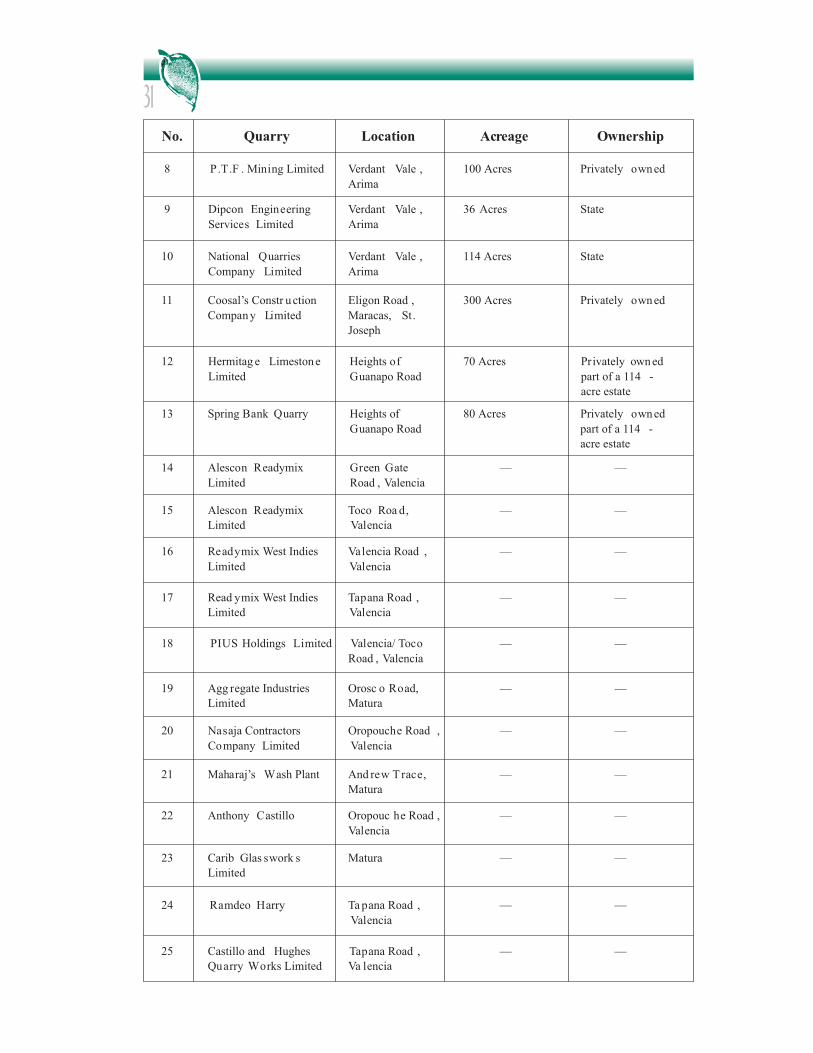
31No. Quarry Location Acreage Ownership
12 Hermitag e Limestone
Limited
Heights of
Guanapo Road
70 Acres Privately owned
part of a 114 -
acre estate
8 P.T.F . Mining Limited Verdant Vale ,
Arima
100 Acres Privately owned
9 Dipcon Engineering
Services Limited
Verdant Vale ,
Arima
36 Acres State
10 National Quarries
Company Limited
Verdant Vale ,
Arima
114 Acres State
11 Coosal’s Constr uction
Company Limited
Eligon Road ,
Maracas, St.
Joseph
300 Acres Privately owned
13 Spring Bank Quarry Heights of
Guanapo Road
80 Acres Privately owned
part of a 114 -
acre estate
14 Alescon Readymix
Limited
Green Gate
Road , Valencia
— —
15 Alescon Readymix
Limited
Toco Roa d,
Valencia
— —
16 Readymix West Indies
Limited
Valencia Road ,
Valencia
— —
17 Read ymix West Indies
Limited
Tapana Road ,
Valencia
— —
18 PIUS Holdings Limited Valencia/ Toco
Road , Valencia
— —
19 Agg regate Industries
Limited
Orosc o Road,
Matura
— —
20 Nasaja Contractors
Company Limited
Oropouche Road ,
Valencia
— —
21 Maharaj’s Wash Plant And rew Trace,
Matura
— —
22 Anthony Castillo Oropouc he Road ,
Valencia
— —
23 Carib Glas swork s
Limited
Matura — —
24 Ramdeo Harry Ta pana Road ,
Valencia
— —
25 Castillo and Hughes
Quarry Works Limited
Tapana Road ,
Va lencia
— —

32
5.2.3.1.5 Commercial/Industrial development
Industrial development, including smaller commercial and administrative activities, occurs onlyon the southern flanks of the Northern Range (Fig. 12), stretching from Chaguaramas to Arima.Some examples of industrial activities include boat building and repairs (Chaguaramas), paintmanufacture (Laventille, Beetham, Wrightson Road), dairy, bakery, soft drinks, and sweets (ElSoccorro, Champ Fleurs), and toiletries (Champ Fleurs; WRMU I, 2001). Industrial activity alongthe Eastern Main Road was identified as a potential source of freshwater pollution (EMA 1998b).
Fig. 12: Northern Range Residential, Commercial, and Municipal (brown);and Industrial (pink) Cover
Source: B. Ramlal and S. Surujdeo-Maharaj (unpublished; pers. commun., 2004)
No. Quarry Location Acreage Ownership
26 Coosal’s Construction
Service s Limited
Block 1 , Tapana
Road , Valencia
— —
27 Coosal’s Construction
Services
Ta pana Road ,
Va lencia
— —
28 Dipcon Engineering
Services Limited
Block 2 , Tapana
Road , Valencia
— —
29 The Ministry of
Agriculture , Land and
Marine Resources
Tapana Bra nch
Road , Valencia
— —
30 Ta pana Q uarry Ta pana Q uarry
Road , Valencia
— —
31 Margaret Yeates William Lane,
Va lencia
— —
32 Dar-ul-Islam Tattoo Trace,
Valencia
— —
33 Caribbean Minerals
Age ncy
Toco Main Road — —
Source: Ministry of Energy and Energy Industries (pers. commun., 2005)

33Agro-processing has impacted negatively on the Santa Cruz/San Juan, Arima, and the Tacariguarivers (EMA 1998b) in addition to the Maracas/St. Joseph River (Lucas 2003; Lucas and Alkins-Koo 2004). Runoff and leaking of underground fuel-storage tanks from service stations haveadversely affected the Santa Cruz/San Juan, Arima, and the North Oropouche rivers.Contamination of the Caroni River and some of its tributaries with industrial effluents (notablysynthetic organic chemicals) is documented (Moore and Karasek 1984). Industrial and othersources of heavy metals also contaminate water and sediments of these rivers at levels above theUnited States and Canadian standards (Mahabir 2003; Surujdeo-Maharaj et al. 2004).
5.2.3.2 Harvesting of Wildlife and Fish
Studies have shown that over-hunting has affected species such as the Pawi, howler monkey, ocelot,and wild hog (ENRP 1991). These will be discussed in more detail in Section 6.1.2.5, in Box 6(the Pawi), and in Annex 3. Over-exploitation of fisheries, birds, and crustaceans on the NorthCoast are of concern for the sustainability of the harvesting activities as well as the health of theecosystems. An assessment conducted by the Fisheries Division of the Ministry of Agriculture,Land and Marine Resources (MALMR) indicated that over-exploited species include carite,croaker, red and vermillion snappers, and yellow mouth grouper (WRA 2001). The nationalincrease in fish catch between 1986 and 1995 has been a result of developments in technology,such as the use of multi-purpose vessels and chilled storage, and has been compounded by the factthat fish stocks are open-access resources and are therefore available for the public to use at will(WRA 2001). Indiscriminate harvesting of oyster species regardless of size and sex has led to acollapse of the oyster industry; this trend may also be seen with mussels in the near future (WRA2001).
Factors involved in over-exploitation include:• Oversized fleet• Greater range of fishing vessels• Inappropriate gear• Open-access resource• Three types of fisheries within the same fishing grounds • Outdated legislation (Fisheries Act is 1916 with several amendments) • Little information on biology of most fish species • Focus on fisheries development rather than management• Increased near-shore pollution from land-based sources: industrial, domestic,
agricultural, and solid waste.The consequences for fisher folk have been increasing fishing effort, falling yields, and decliningfinancial returns. In addition, the coastal and marine environments are being degraded as a resultof the destruction of wetlands.
5.2.3.3 External Inputs
5.2.3.3.1 Land-based sources of pollution
Land-based sources of pollution pose a major threat to the Northern Range freshwater resourcesand thus to coastal environments, as the coastal zone receives water from rivers and drains and istherefore the ultimate sink for effluents generated from land-use activities. A 1998 study by WASAand IMA showed that the lower reaches of some rivers are contaminated by domestic, industrial,and agricultural wastes (WRA 2001). Other studies showed that some of the rivers popular forrecreational activities contain very high levels of faecal bacteria (Lawrence 2004). Pollution levels

34generally increase during the rainy season with increased surface runoff. A study conducted in2000 in the Chaguaramas area showed a higher level of pollutants (lead and chromium) in therainy season (Mohammed et al. 2000).
Pollution has impacted severely on the species composition and abundance in coastal areas (WRA2001). Pollutants affecting the coastal waters are derived from sewage resulting in eutrophicationand consequent dinoflagellate and algal blooms which produce toxins and deplete the oxygenconcentration of the water, respectively, causing fish kills; sediments from indiscriminate quarryingand agricultural activities which inhibit coral growth and smother seagrass beds; and solid wastewhich affects benthic and rocky-shore communities (Boodoosingh 1992). Toxic pollutants fromdomestic grey water, agricultural products, and industrial effluents, including the boat repair andmaintenance industry concentrated within the Chaguaramas Bay area, are also found within thecoastal zone.
Organic pollution in the form of sewage, livestock wastes, and fertilizers deteriorates the waterquality in popular recreational beaches. There has been a decrease in water quality in Maracas Bayfrom 1995 to 2001 as the western end of the beach (near to the mouth of the Maracas Bay River)is no longer suitable for swimming according to international standards, even in the dry season(Bullock and Moonesar 2001). The eastern section remains safe but only because the currents areflowing in a westerly direction (Bullock and Moonesar 2001).
The numerous bush fires which ravage terrestrial vegetation during the dry season continue to taketheir toll on coastal vegetation during the rainy season, as exposed soil runs off into the sea,smothering coastal systems like the seagrass beds. Deforestation on the Northern Range slopes hasalso led to increased sedimentation in rivers, especially during the rainy season and therefore in thecoastal waters (WRA 2001). The coastal waters polluted with solid waste become unappealing andmurky in appearance. The unseen pathogens in the waters pose potential health hazards to bathers,especially to the more vulnerable young and elderly groups.
5.2.3.3.2 Wastewater treatment
Many wastewater treatment plants in Trinidad are not meeting national effluent standards and aretherefore a major source of pollution (The Trinidad Guardian, 25/08/2003, p. 8). The wastewatersector is ultimately managed by WASA but the inadequate system is in part due to the avoidanceof responsibility by private housing/land developers. Thirteen of the 16 operating treatmentplants in the Northern Range are privately managed (Rodriguez-Atwell 2000) and an increase inprivate-sector stewardship can improve the system, but the returns on the financial investments arenot viable.
Chronic or incidental pollution with untreated sewage wastewater or domestic grey water increasesBOD and decreases dissolved oxygen, leading to eutrophication. While this may generate algalbiodiversity, the trade-off is that it may also lead to fish kills or ecosystem degradation and loss ofaesthetics.
It is expected that the Beetham waste-water treatment plant which has recently beenoperationalized will alleviate the problem of waste-water contamination in the Port-of-Spain area.Preliminary testing of the water exiting this plant indicates that the water may be of a good enoughquality to be used for the irrigation of agricultural lands, and this may help to meet Trinidad'swater demand more adequately in the future.

355.2.3.3.3 Solid-waste disposal
Large appliances and vehicles are commonly found in both forested areas and in ravines and rivers.In addition small operators of commercial enterprises (e.g., vendors) use these as alternatives toauthorized dump sites. There have also been incidents of dumping of heavy metal waste on riverbanks thus leading to potential contamination of surface and ground waters via leaching of solublecomponents.
From the discussion in Section 5, it is evident that a range of factors (economic, demographic,institutional, natural, behavioural, technological) operates and interplays to explain how theNorthern Range and its assets are being affected. The nature of the impacts has also beenidentified. The consequences of these impacts for the ecosystem and the services it provides, as wellas their relationship with our well-being, are explored in the following section.
6.1 Biodiversity
6.1.1 Links between Biological Diversity and Human Well-being
The Convention on Biological Diversity (CBD) defines biological diversity (or biodiversity) as 'thevariability among living organisms from all sources including, inter alia, terrestrial, marine andother aquatic ecosystems and the ecological complexes of which they are a part; this includesdiversity within species, between species and of ecosystems' (CBD 2001).
Humans benefit in many ways from the biodiversity of ecosystems-directly through theprovisioning of biological products (such as food and timber), and from the cultural servicesprovided by the aesthetic value of the ecosystem; and more indirectly and discreetly, from thesupporting services provided by the diversity of an ecosystem. An example of the supportingservice of biodiversity is where, in a terrestrial system, both the floral and faunal diversity help inthe process of soil formation and in the cycling of nutrients in the ecosystem. We might alsoconsider a river ecosystem in which the plant and animal species, and the interactions amongthem, help to maintain the water quality; the removal of certain species could have marked effectson the quality of the water in that freshwater ecosystem. Some species also serve as indicators ofpollution and their presence could be important to the monitoring and management for waterquality (e.g., Cladophora). Humans may not directly utilize all the products of the river, butwithout the diversity of these biological resources the quality of the water in the river may not besuitable as potable water for human use. In this way therefore, the elements of biodiversityunderpin the ability of ecosystems to provide their ecological services, which support life on earth(MA 2003).19
6.1.2 Links between Northern Range Biodiversity and Human Well-being
Generally, the biodiversity of the Northern Range is a cross-cutting factor which contributes tohuman well-being in four ways: through its provisioning, cultural, supporting, and regulatingservices. The benefits gained from the provisioning aspects of biodiversity are quantifiable and canbe economically valued; thus these links are fairly straightforward. The cultural services include thebenefits gained from the amenity value (recreation and eco-tourism) as well as the educational
6.0 Assessment of Northern Range Ecosystem Services
19Several published documents have already addressed the links between ecosystem services and biodiversity (e.g., Myers 1996) and have concluded thatbiodiversity is essential for sustaining ecological function. The current document does not seek to review this literature but rather focuses specifically onthe Northern Range.