le maps - zolinsoft.comzolinsoft.com/cis1730/murach.powerpoint.pdfs/chapter16slides.pdf · chapter...
TRANSCRIPT

Chapter 16
Murach's JavaScript and jQuery, C16 © 2012, Mike Murach & Associates, Inc. Slide 1
How to use the API for Google Maps

Objectives
Murach's JavaScript and jQuery, C16 © 2012, Mike Murach & Associates, Inc. Slide 2
Applied
1. Use the API for Google Maps to add a map to a web page that
includes markers and messages.
2. Use the API for Google Maps to provide driving directions
between two points on a map.
Knowledge
1. Describe the use of the Google Maps API in terms of classes,
constructors, objects, methods, and properties.
2. Describe the geocoding feature of Google Maps.
3. Describe the use of listeners with the Google Maps API.
4. Describe the way that driving directions are provided with the
Google Maps API.

Google URLs
Murach's JavaScript and jQuery, C16 © 2012, Mike Murach & Associates, Inc. Slide 3
The URL for the Google APIs Services Console
code.google.com/apis/console/
The base URL for the Google Maps API documentation (on one line)
developers.google.com/maps/documentation/javascript/
reference

The web page for the start of the API reference
Murach's JavaScript and jQuery, C16 © 2012, Mike Murach & Associates, Inc. Slide 4

How to get a key for the Google Maps API
Murach's JavaScript and jQuery, C16 © 2012, Mike Murach & Associates, Inc. Slide 5
1. Go to the URL for the APIs services console that’s shown above,
and log in.
2. If this is the first time you’ve used the Google APIs, you’ll be
redirected to a welcome screen where you can click a “Create
project” button. Then, click that button to go to the Console page.
3. Click on the Services link in the left sidebar.
4. Scroll down and enable the API v3 by changing its switch from
“off” to “on”.

The classes for adding a map to a web page
Murach's JavaScript and jQuery, C16 © 2012, Mike Murach & Associates, Inc. Slide 6
Map(element, options)
LatLng(latitude, longitude)
MapTypeId
The base URL for the Google Maps API reference (on one line)
developers.google.com/maps/documentation/javascript/
reference
The placeholders for specific classes #Map
#MapTypeId
#LatLng
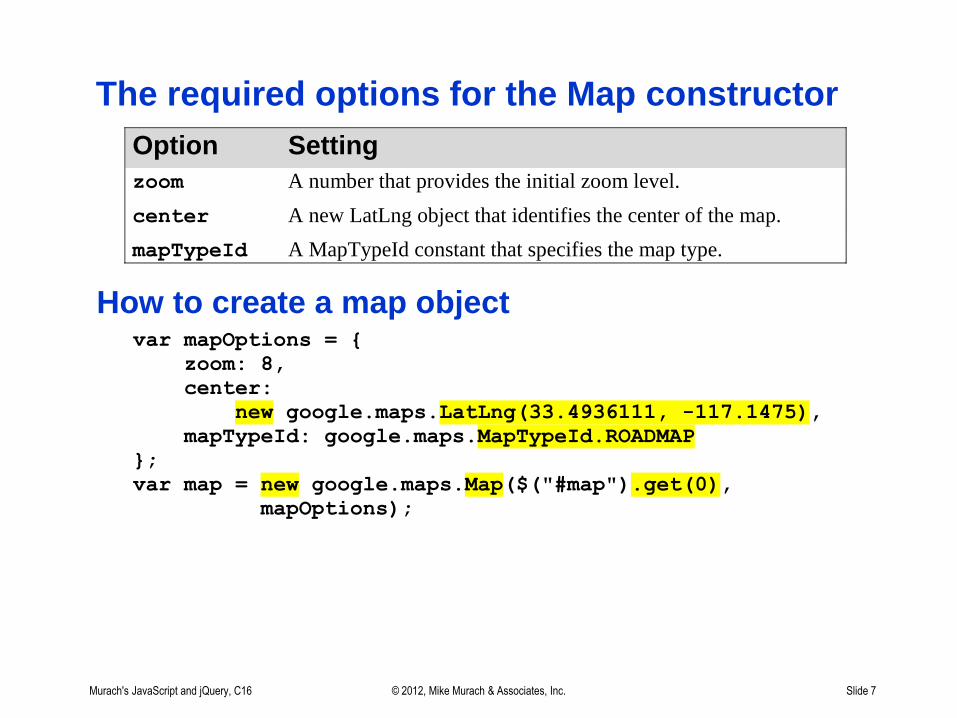
The required options for the Map constructor
Murach's JavaScript and jQuery, C16 © 2012, Mike Murach & Associates, Inc. Slide 7
Option Setting
zoom A number that provides the initial zoom level.
center A new LatLng object that identifies the center of the map.
mapTypeId A MapTypeId constant that specifies the map type.
How to create a map object var mapOptions = {
zoom: 8,
center:
new google.maps.LatLng(33.4936111, -117.1475),
mapTypeId: google.maps.MapTypeId.ROADMAP
};
var map = new google.maps.Map($("#map").get(0),
mapOptions);

Terms
Murach's JavaScript and jQuery, C16 © 2012, Mike Murach & Associates, Inc. Slide 8
constructor
class
object
method
property

A web page that displays a Google map
Murach's JavaScript and jQuery, C16 © 2012, Mike Murach & Associates, Inc. Slide 9
The HTML for the div element that will get the map <div id="map"></div>

The script element for the Google Maps API
Murach's JavaScript and jQuery, C16 © 2012, Mike Murach & Associates, Inc. Slide 10
<script
src="https://maps.googleapis.com/maps/api/js?key=" +
your_api_key + "&sensor=false">
</script>

The jQuery for creating the map
Murach's JavaScript and jQuery, C16 © 2012, Mike Murach & Associates, Inc. Slide 11
$(document).ready(function(){
var mapOptions = {
zoom: 8,
center:
new google.maps.LatLng(33.4936111, -117.1475),
mapTypeId: google.maps.MapTypeId.ROADMAP
};
var map =
new google.maps.Map($("#map").get(0), mapOptions);
});

Members of the Geocoder class
Murach's JavaScript and jQuery, C16 © 2012, Mike Murach & Associates, Inc. Slide 12
One of the methods of the Geocoder class
geocode(request, callback)
Two of the properties of the GeocoderRequest object
address
location
Three of the properties of the GeocoderResult object
address_components
formatted_address
geometry.location
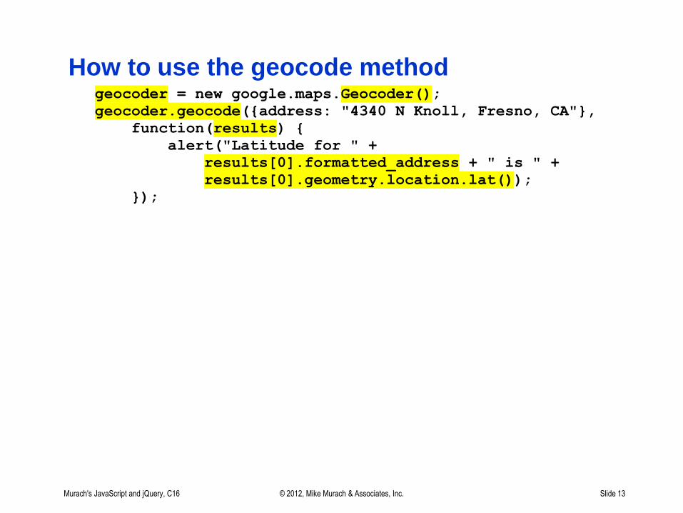
How to use the geocode method
Murach's JavaScript and jQuery, C16 © 2012, Mike Murach & Associates, Inc. Slide 13
geocoder = new google.maps.Geocoder();
geocoder.geocode({address: "4340 N Knoll, Fresno, CA"},
function(results) {
alert("Latitude for " +
results[0].formatted_address + " is " +
results[0].geometry.location.lat());
});

How to create a Marker object
Murach's JavaScript and jQuery, C16 © 2012, Mike Murach & Associates, Inc. Slide 14
var marker = new google.maps.Marker({
position:
new google.maps.LatLng(36.799793, -119.858135),
map: map});
// this assumes the map object is in a variable named map

A marker is added to the map
when the user clicks on an address link
Murach's JavaScript and jQuery, C16 © 2012, Mike Murach & Associates, Inc. Slide 15

The HTML for the map and links
Murach's JavaScript and jQuery, C16 © 2012, Mike Murach & Associates, Inc. Slide 16
<div id="map"></div>
<ul id="links">
<li><a href="#">Los Angeles, CA</a></li>
<li><a href="#">Temecula, CA</a></li>
<!-- the li elements for other cities -->
</ul>

The jQuery for the map and markers
Murach's JavaScript and jQuery, C16 © 2012, Mike Murach & Associates, Inc. Slide 17
$(document).ready(function(){
var geocoder = new google.maps.Geocoder();
var myLatLng =
new google.maps.LatLng(33.4936111, -117.1475);
var mapOptions = {zoom: 8, center: myLatLng,
mapTypeId: google.maps.MapTypeId.ROADMAP};
var map = new google.maps.Map($("#map").get(0),
mapOptions);
$("#links a").click(function() {
// gets address from <a> element
var address = $(this).text();
geocoder.geocode({address: address},
function(results) {
new google.maps.Marker({
position: results[0].geometry.location,
map: map
});
});
});
});

A marker and message ballon are added
when the user clicks on a link
Murach's JavaScript and jQuery, C16 © 2012, Mike Murach & Associates, Inc. Slide 18

Members of the InfoWindow and Marker classes
Murach's JavaScript and jQuery, C16 © 2012, Mike Murach & Associates, Inc. Slide 19
One method of the InfoWindow class
open(map, marker) Opens the message balloon for the map and marker.
Two methods of the Marker class
getPosition() Gets the latitude and longitude coordinates of the
marker.
setMap(map) Renders the marker on the specified map. If the
parameter is null, it removes the marker from the map.

The jQuery for displaying the message balloon
Murach's JavaScript and jQuery, C16 © 2012, Mike Murach & Associates, Inc. Slide 20
$(document).ready(function(){
var marker;
var geocoder = new google.maps.Geocoder();
var myLatlng =
new google.maps.LatLng(33.4936111, -117.1475);
var mapOptions = {zoom: 8, center: myLatlng,
mapTypeId: google.maps.MapTypeId.ROADMAP};
var map = new google.maps.Map($("#map").get(0),
mapOptions);
$("#links a").click(function() {
// get address from <a> element
var address = $(this).text();
// delete current marker (if any)
if (marker) { marker.setMap(null); }

The jQuery (continued)
Murach's JavaScript and jQuery, C16 © 2012, Mike Murach & Associates, Inc. Slide 21
geocoder.geocode({address: address},
function(results) {
marker = new google.maps.Marker({
position: results[0].geometry.location,
map: map
});
// add message balloon
var infoWindow =
new google.maps.InfoWindow({
content:
"This is: <h3>" + address + "</h3>"}
);
infoWindow.open(map, marker);
});
});
});

The classes for adding custom messages
Murach's JavaScript and jQuery, C16 © 2012, Mike Murach & Associates, Inc. Slide 22
OverlayView() This constructor creates an object that can be used to
overlay objects on the map.
MapCanvasProjection An object is created from this class by the
getProjection method of an OverlayView object.
Three methods of the OverlayView class draw() Draws or updates the overlay.
setMap(map) Adds the overlay to the map.
getProjection() Returns a MapCanvasProjection object.
One method of the MapCanvasProjection class fromLatLngToContainerPixel(markerPosition)
Returns the pixel coordinates for a marker’s position.

A web page that displays
a custom message for a marker
Murach's JavaScript and jQuery, C16 © 2012, Mike Murach & Associates, Inc. Slide 23

The HTML for the message balloon
Murach's JavaScript and jQuery, C16 © 2012, Mike Murach & Associates, Inc. Slide 24
<div id="message" style="display:none;"></div>

The jQuery for the custom messages
Murach's JavaScript and jQuery, C16 © 2012, Mike Murach & Associates, Inc. Slide 25
$(document).ready(function(){
// same first 5 statements as before
$("#links a").click(function() {
var address = $(this).text();
if (marker) { marker.setMap(null); }
geocoder.geocode({address: address},
function(results) {
marker = new google.maps.Marker({
position: results[0].geometry.location,
map: map
});
var overlay = new google.maps.OverlayView();
overlay.draw = function() {
var point =
overlay.getProjection()
.fromLatLngToContainerPixel(
marker.getPosition());

The jQuery (continued)
Murach's JavaScript and jQuery, C16 © 2012, Mike Murach & Associates, Inc. Slide 26
$("#message").html(
"This is: " + address + "<br>" +
"<a href=http://maps.google.com/maps? " +
"daddr=" + address +
">Get directions to here</a>");
$("#message").show().css({
top: point.y + 10,
left: point.x
});
};
overlay.setMap(map);
});
});
});

A web page with a Flickr image for the location
Murach's JavaScript and jQuery, C16 © 2012, Mike Murach & Associates, Inc. Slide 27

The jQuery for setting up the click event handlers
Murach's JavaScript and jQuery, C16 © 2012, Mike Murach & Associates, Inc. Slide 28
// the same code as before
$("#links a").click(function() {
var address = $(this).text();
if (marker) { marker.setMap(null); }
geocoder.geocode({address: address},
function(results) {
marker = new google.maps.Marker({
position: results[0].geometry.location,
map: map
});
var overlay = new google.maps.OverlayView();
overlay.draw = function() {
var point =
overlay.getProjection()
.fromLatLngToContainerPixel(
marker.getPosition());

The jQuery (continued)
Murach's JavaScript and jQuery, C16 © 2012, Mike Murach & Associates, Inc. Slide 29
// the changed code for this application
var url = "http://api.flickr.com/services/" +
"feeds/photos_public.gne?" +
"format=json&jsoncallback=?&tags=" +
address;
$.getJSON(url, function(data) {
$.each(data.items, function(i, item){
$("#message").html(address +
"<br><img src=" +
item.media.m +
" width=150 height=100>");
});
});
$("#message").show().css({
top: point.y + 10,
left: point.x
});
};
overlay.setMap(map);
});
});

The classes for getting and displaying directions
Murach's JavaScript and jQuery, C16 © 2012, Mike Murach & Associates, Inc. Slide 30
Class Description
DirectionsService() This constructor creates an object that can be used to
retrieve driving directions from the Google server.
DirectionsRenderer() This constructor creates an object that can be used to
render driving directions.
TravelMode This class provides contants for four travel modes:
DRIVING, BICYCLING, TRANSIT, and
WALKING.

One method of the DirectionsService class
Murach's JavaScript and jQuery, C16 © 2012, Mike Murach & Associates, Inc. Slide 31
Member Description
route(request, callback) The first parameter is a DirectionsRequest
object that has three required properties: origin
(starting location), destination, and travel
mode.
This method returns a DirectionsResult object
and a DirectionsStatus object.

Three members of the DirectionsRenderer class
Murach's JavaScript and jQuery, C16 © 2012, Mike Murach & Associates, Inc. Slide 32
Member Description
setMap(map) Specifies the map for which directions will be
rendered.
setPanel(panel) Specifies the HTML div element that will receive the
directions.
setDirections(result) Renders the result of a directions request in a div
element.

A typical directions request
Murach's JavaScript and jQuery, C16 © 2012, Mike Murach & Associates, Inc. Slide 33
var request = {
origin: marker1.getPosition(),
destination: marker2.getPosition(),
travelMode: google.maps.TravelMode.DRIVING
};
directionsService.route(request,
function(result, status) {
directionsRenderer.setDirections(result);
});

Three methods of the event namespace
for using event handlers
Murach's JavaScript and jQuery, C16 © 2012, Mike Murach & Associates, Inc. Slide 34
Method Description
addListener(object, event, handler)
Registers an event handler for an object and
event. It returns an event object that has
properties related to the event.
removeListener(listener) Removes the specified listener.
trigger(object, event) Fires the specified event for the specified
object.

How to use the addListener method
Murach's JavaScript and jQuery, C16 © 2012, Mike Murach & Associates, Inc. Slide 35
google.maps.event.addListener(marker, "click",
function(event) {
// code for the event handler
});

A web page that displays driving directions
Murach's JavaScript and jQuery, C16 © 2012, Mike Murach & Associates, Inc. Slide 36

The HTML for the map and directions panel
Murach's JavaScript and jQuery, C16 © 2012, Mike Murach & Associates, Inc. Slide 37
<div id="map"></div>
<div id="directions"></div>

The jQuery for displaying the directions
Murach's JavaScript and jQuery, C16 © 2012, Mike Murach & Associates, Inc. Slide 38
// the code in the ready event handler
var directionsService =
new google.maps.DirectionsService();
var markers = [];
var myLatlng =
new google.maps.LatLng(33.4936111, -117.1475);
var mapOptions =
{zoom: 8,
center: myLatlng,
mapTypeId: google.maps.MapTypeId.ROADMAP};
var map =
new google.maps.Map($("#map").get(0), mapOptions);

The jQuery (continued)
Murach's JavaScript and jQuery, C16 © 2012, Mike Murach & Associates, Inc. Slide 39
// the listener for the click event of the map
var listener = google.maps.event.addListener(map, "click",
function(event) {
var marker =
new google.maps.Marker({
position: event.latLng, map: map});
markers.push(marker);
if (markers.length > 1) {
google.maps.event.removeListener(listener);
var marker1 = markers[0];
var marker2 = markers[1];
var directionsRenderer =
new google.maps.DirectionsRenderer();
directionsRenderer.setMap(map);
directionsRenderer.setPanel($("#directions")
.get(0));
var request = {
origin: marker1.getPosition(),
destination: marker2.getPosition(),
travelMode: google.maps.TravelMode.DRIVING };

The jQuery (continued)
Murach's JavaScript and jQuery, C16 © 2012, Mike Murach & Associates, Inc. Slide 40
// get directions
directionsService.route(request,
function(result, status) {
if
(status == google.maps.DirectionsStatus.OK)
{
directionsRenderer.setDirections(result);
}
});
}
});

Exercise 16-1: Enhance a map application
Murach's JavaScript and jQuery, C16 © 2012, Mike Murach & Associates, Inc. Slide 41

Extra 16-1: Create a Google map
Murach's JavaScript and jQuery, C16 © 2012, Mike Murach & Associates, Inc. Slide 42
The center of the map should be at the address that the user enters.

Extra 16-2: Provide Google Map directions
Murach's JavaScript and jQuery, C16 © 2012, Mike Murach & Associates, Inc. Slide 43
The starting address should be the one the user enters.
The destination address should be the one used for the center of the map.

Short 16-1: Add markers to a map
Murach's JavaScript and jQuery, C16 © 2012, Mike Murach & Associates, Inc. Slide 44
Estimated time: 15 to 20 minutes.