lease plan of operations application -...
TRANSCRIPT

LEASE PLAN OF OPERATIONS APPLICATION State of Alaska
Department of Natural Resources, Division of Oil & Gas 550 W. 7th Ave, Suite 1100, Anchorage, AK 99501-3563
Phone: 907-269-8800 Fax: 907-269-8943 Permitting Email: [email protected]
Revised 04/13/2015 Page 1 of 24
SECTION I: APPLICANT INFORMATION 1. Applicant: 2. Applicant Contact:
Name: Burgundy Xploration (BEX) First Name: David Last
Name: Wall
Title: President, Accumulate Energy Alaska, Inc.
Mailing Address: PO Box 112212 Is the Mailing Address the same as Applicant’s Mailing Address? If “No”, please provide information below:
☒ Yes
City: Anchorage Mailing Address: Enter Mailing Address.
State: Alaska Zip Code: 99511-2212 City: Enter City. State: Enter State. Zip Code: Enter Zip
Code. Phone: 907-244-5210 Fax: 907-349-1920 Phone: +61408718440 Fax: +61893218990
Email: [email protected] Email: [email protected]
SECTION II: THIRD PARTY INFORMATION (Fill out this section only if you are applying for the Applicant)
SECTION III: APPLICATION DATE AND NUMBER (FOR OFFICE USE ONLY)
Third Party Company Name: Fairweather Science Application Date: First Name: Willow Last
Name: Hetrick
Title: Staff Scientist Mailing Address: 301 Calista Court
City: Anchorage State: Alaska, Zip Code: 99518 Phone: 907-330-9085 Fax: 907-349-1920 Email: [email protected] Describe the affiliation to the Applicant: Application Number: Fairweather Science is the acting agent to conduct permitting and planning for an exploration well, Icewine #1, on the North Slope.
SECTION IV: PROJECT SCOPE 1. Project Name: Icewine #1 Exploration Well 2. Proposed Start Date: 7/1/2015
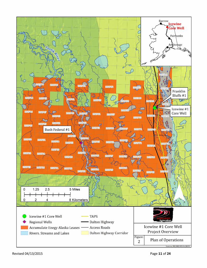
3. Project Description: Describe what and where: Burgundy Xploration (BEX) was awarded 98,182 contiguous onshore acres in Alaska near the White Hills (hereby referred to as the Icewine project area), refer Figure 1. BEX formed a Joint Venture with Accumulate Energy Alaska, Inc. (AEA) who will eventually be the operator of the Icewine project but because of timing complexities related to assignment of lessee, BEX is continuing the plan of operation permit process with the Division of Oil and Gas with the plan of later transferring the lease and this application to AEA. This Plan of Operation describes activities to drill one vertical well, Icewine #1, to take core in potentially petroliferous zones in both unconventional and conventional reservoirs on a lease operated by BEX during the 2015 season. The goal of this pilot drill program is to analyze the potential productivity, deliverability, and commerciality of the greater Icewine project area. Depending on results from initial drilling and the time remaining in the season, BEX may drill a lateral well, sidetracks or additional penetrations from the same exploration pad.
Revised 04/13/2015 Page 2 of 24
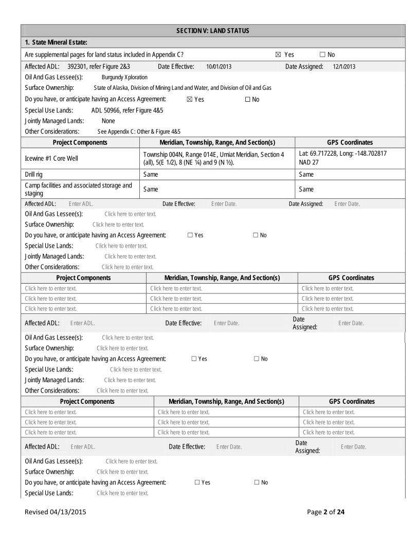
SECTION V: LAND STATUS 1. State Mineral Estate:
Are supplemental pages for land status included in Appendix C? ☒ Yes ☐ No Affected ADL: 392301, refer Figure 2&3 Date Effective: 10/01/2013 Date Assigned: 12/1/2013 Oil And Gas Lessee(s): Burgundy Xploration Surface Ownership: State of Alaska, Division of Mining Land and Water, and Division of Oil and Gas
Do you have, or anticipate having an Access Agreement: ☒ Yes ☐ No Special Use Lands: ADL 50966, refer Figure 4&5 Jointly Managed Lands: None Other Considerations: See Appendix C: Other & Figure 4&5
Project Components Meridian, Township, Range, And Section(s) GPS Coordinates
Icewine #1 Core Well Township 004N, Range 014E, Umiat Meridian, Section 4 (all), 5(E 1/2), 8 (NE ¼) and 9 (N ½).
Lat: 69.717228, Long: -148.702817 NAD 27
Drill rig Same Same
Camp facilities and associated storage and staging Same Same
Affected ADL: Enter ADL. Date Effective: Enter Date. Date Assigned: Enter Date. Oil And Gas Lessee(s): Click here to enter text. Surface Ownership: Click here to enter text.
Do you have, or anticipate having an Access Agreement: ☐ Yes ☐ No
Special Use Lands: Click here to enter text. Jointly Managed Lands: Click here to enter text. Other Considerations: Click here to enter text.
Project Components Meridian, Township, Range, And Section(s) GPS Coordinates Click here to enter text. Click here to enter text. Click here to enter text. Click here to enter text. Click here to enter text. Click here to enter text. Click here to enter text. Click here to enter text. Click here to enter text.
Affected ADL: Enter ADL. Date Effective: Enter Date. Date Assigned: Enter Date.
Oil And Gas Lessee(s): Click here to enter text. Surface Ownership: Click here to enter text.
Do you have, or anticipate having an Access Agreement: ☐ Yes ☐ No
Special Use Lands: Click here to enter text.

Revised 04/13/2015 Page 3 of 24
Jointly Managed Lands: Click here to enter text. Other Considerations: Click here to enter text.
Project Components Meridian, Township, Range, And Section(s) GPS Coordinates Click here to enter text. Click here to enter text. Click here to enter text. Click here to enter text. Click here to enter text. Click here to enter text. Click here to enter text. Click here to enter text. Click here to enter text.
Affected ADL: Enter ADL. Date Effective: Enter Date. Date Assigned: Enter Date.
Oil And Gas Lessee(s): Click here to enter text. Surface Ownership: Click here to enter text.
Do you have, or anticipate having an Access Agreement: ☐ Yes ☐ No
Special Use Lands: Click here to enter text. Jointly Managed Lands: Click here to enter text. Other Considerations: Click here to enter text.
Project Components Meridian, Township, Range, And Section(s) GPS Coordinates Click here to enter text. Click here to enter text. Click here to enter text. Click here to enter text. Click here to enter text. Click here to enter text. Click here to enter text. Click here to enter text. Click here to enter text.
2. State of Alaska Surface Lands:
Are supplemental pages for land status included in Appendix C? ☐ Yes ☒ No Oil And Gas Mineral Estate Owner: N/A Access Authorization(s): N/A Special Use Lands: N/A Jointly Managed Lands: N/A
Other Considerations: N/A
Project Components Meridian, Township, Range, And Section(s) GPS Coordinates N/A N/A N/A Click here to enter text. Click here to enter text. Click here to enter text. Click here to enter text. Click here to enter text. Click here to enter text. Oil And Gas Mineral Estate Owner: Click here to enter text.
Access Authorization(s): Click here to enter text. Special Use Lands: Click here to enter text. Jointly Managed Lands: Click here to enter text. Other Considerations: Click here to enter text.
Project Components Meridian, Township, Range, And Section(s) GPS Coordinates Click here to enter text. Click here to enter text. Click here to enter text. Click here to enter text. Click here to enter text. Click here to enter text. Click here to enter text. Click here to enter text. Click here to enter text. Oil And Gas Mineral Estate Owner: Click here to enter text. Access Authorization(s): Click here to enter text. Special Use Lands: Click here to enter text. Jointly Managed Lands: Click here to enter text. Other Considerations: Click here to enter text.
Project Components Meridian, Township, Range, And Section(s) GPS Coordinates Click here to enter text. Click here to enter text. Click here to enter text.
Revised 04/13/2015 Page 4 of 24
Click here to enter text. Click here to enter text. Click here to enter text. Click here to enter text. Click here to enter text. Click here to enter text.
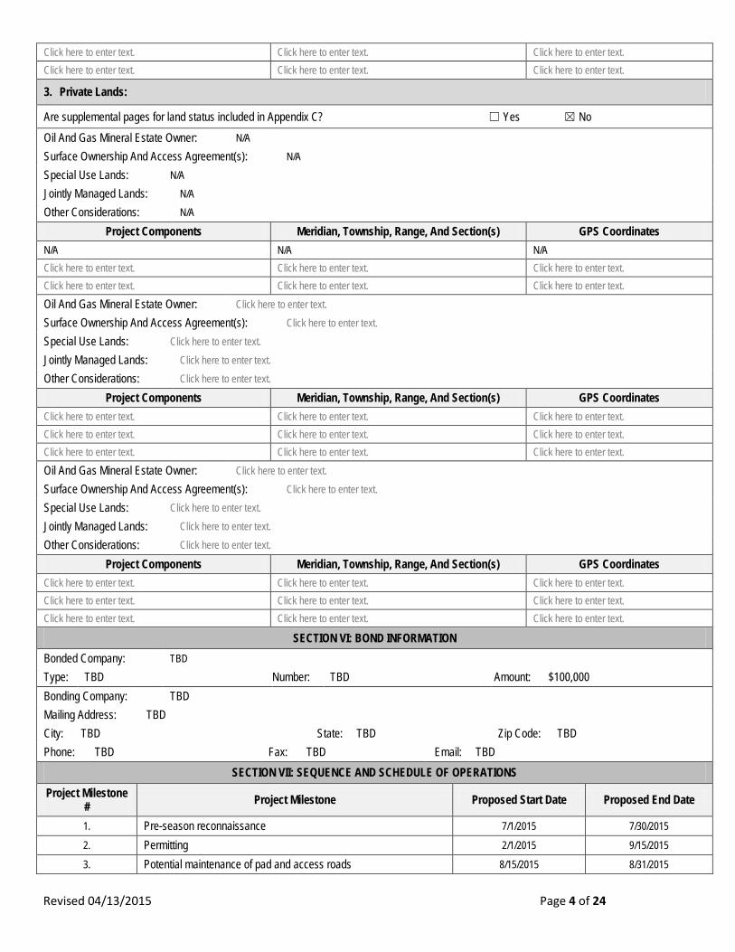
3. Private Lands:
Are supplemental pages for land status included in Appendix C? ☐ Yes ☒ No Oil And Gas Mineral Estate Owner: N/A Surface Ownership And Access Agreement(s): N/A Special Use Lands: N/A Jointly Managed Lands: N/A Other Considerations: N/A
Project Components Meridian, Township, Range, And Section(s) GPS Coordinates N/A N/A N/A Click here to enter text. Click here to enter text. Click here to enter text. Click here to enter text. Click here to enter text. Click here to enter text. Oil And Gas Mineral Estate Owner: Click here to enter text. Surface Ownership And Access Agreement(s): Click here to enter text. Special Use Lands: Click here to enter text. Jointly Managed Lands: Click here to enter text. Other Considerations: Click here to enter text.
Project Components Meridian, Township, Range, And Section(s) GPS Coordinates Click here to enter text. Click here to enter text. Click here to enter text. Click here to enter text. Click here to enter text. Click here to enter text. Click here to enter text. Click here to enter text. Click here to enter text. Oil And Gas Mineral Estate Owner: Click here to enter text. Surface Ownership And Access Agreement(s): Click here to enter text. Special Use Lands: Click here to enter text.
Jointly Managed Lands: Click here to enter text.
Other Considerations: Click here to enter text.
Project Components Meridian, Township, Range, And Section(s) GPS Coordinates Click here to enter text. Click here to enter text. Click here to enter text. Click here to enter text. Click here to enter text. Click here to enter text. Click here to enter text. Click here to enter text. Click here to enter text.
SECTION VI: BOND INFORMATION Bonded Company: TBD Type: TBD Number: TBD Amount: $100,000
Bonding Company: TBD Mailing Address: TBD City: TBD State: TBD Zip Code: TBD Phone: TBD Fax: TBD Email: TBD
SECTION VII: SEQUENCE AND SCHEDULE OF OPERATIONS Project Milestone
# Project Milestone Proposed Start Date Proposed End Date
1. Pre-season reconnaissance 7/1/2015 7/30/2015
2. Permitting 2/1/2015 9/15/2015
3. Potential maintenance of pad and access roads 8/15/2015 8/31/2015
Revised 04/13/2015 Page 5 of 24
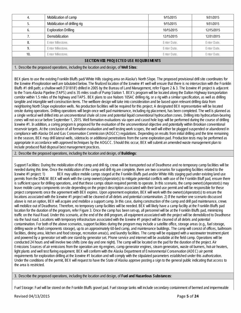
4. Mobilization of camp 9/15/2015 9/31/2015
5. Mobilization of drilling rig 9/15/2015 9/31/2015
6. Exploration Drilling 10/15/2015 12/15/2015
7. Demobilization 12/15/2015 12/31/2015 8. Enter Milestone. Enter Date. Enter Date. 9. Enter Milestone. Enter Date. Enter Date.
10. Enter Milestone. Enter Date. Enter Date.
SECTION VIII: PROJECTED USE REQUIREMENTS 1. Describe the proposed operations, including the location and design, of Well Sites: BEX plans to use the existing Franklin Bluffs pad/ White Hills staging area on Alaska’s North Slope. The proposed provisional drill site coordinates for the Icewine #1exploration well are tabulated below. The finalized location of the Icewine #1 well will ensure that there is no intersection with the Franklin Bluffs #1 drill path; a shallow well (TD1818’) drilled in 2005 by the Bureau of Land Management, refer Figure 2 & 3. The Icewine #1 project is adjacent to the Trans-Alaska Pipeline (TAPS) and is 35 miles south of Pump Station 1. BEX’s program will be located along the Dalton Highway transportation corridor within 1.5 miles of the highway and TAPS. BEX plans to use Nabors 105AC drilling rig, or a rig with a similar specification, as well as drilling tangible and intangible well construction items. The wellbore design will take into consideration and be based upon relevant drilling data from neighboring North Slope exploration wells. No production facilities will be required for this project. A designated BEX representative will be located onsite during operations. Drilling operations will begin once well pad maintenance, including rig placement, has been completed. The well is planned as a single vertical well drilled into an unconventional shale oil zone and potential liquid conventional hydrocarbon zones. Drilling into hydrocarbon-bearing zones will not occur before September 1, 2015. Well formation evaluations via open and cased hole logs will be performed during the course of drilling Icewine #1. In addition, a coring program is proposed for the evaluation of the unconventional objective and potentially within Brookian conventional reservoir targets. At the conclusion of all formation evaluation and well testing work scopes, the well will either be plugged suspended or abandoned in compliance with Alaska Oil and Gas Conservation Commission (AOGCC) regulations. Depending on results from initial drilling and the time remaining in the season, BEX may drill lateral wells, sidetracks or additional penetrations from the same exploration pad. Production tests may be performed as appropriate in accordance with approved techniques by the AOGCC. Should this occur, BEX will submit an amended waste management plan to include produced fluid disposal best management practices. 2. Describe the proposed operations, including the location and design, of Buildings: Support Facilities: During the mobilization of the camp and drill rig, crews will be transported out of Deadhorse and no temporary camp facilities will be needed during this time. Once the mobilization of the camp and drill rig are complete, there are two scenarios for supporting facilities related to the Icewine #1 project: 1) BEX may utilize mobile camps staged at the Franklin Bluffs pad and/or White Hills staging pad under existing land use permits from the DMLW. BEX will work with the camp owner(s)/operator(s) to mitigate potential conflicts with use of the Franklin Bluff pad, ensure there is sufficient space for drilling operations, and that these camps obtain required permits to operate. In this scenario, the camp owner(s)/operator(s) may leave mobile camp components on-site depending on the project description associated with their land use permit and will be responsible for these project components once the agreement with BEX expires. Upon agreement expiration, BEX will work with the owner(s)/operator(s) to ensure the locations associated with the Icewine #1 project will be cleaned of all debris and potential contamination. 2) If the number one scenario discussed above is not an option, BEX will acquire and mobilize a support camp. In this case, during construction of the camp and drill pad maintenance, crews will mobilize out of Deadhorse. Therefore, no temporary camp facilities will be needed. BEX will likely have a camp facility at the Franklin Bluffs pad location for the duration of the program, refer Figure 3. Once the camp has been set-up, all personnel will be at the Franklin Bluffs pad, minimizing traffic on the Haul Road. Under this scenario, at the end of the drill program, all equipment associated with the project will be demobilized to Deadhorse via the haul road. Locations with temporary infrastructure associated with the Icewine #1 project will be cleaned of all debris and potential contamination. For both of the above scenarios, support facilities during the program may include a satellite office, storage areas (e.g., fuel storage, drilling waste or fluid components storage), up to an approximately 60-bed camp, and maintenance buildings. The camp will consist of offices, bathroom facilities, dining area, kitchen and food storage, recreation area(s), and laundry facilities. The camp will be equipped with a wastewater treatment plant and powered by a generator set with one stand-by generator set. Phone service and internet will be available at the field camp. Operations will be conducted 24 hours and will involve two shifts (one day and one night). The camp will be located on the pad for the duration of the project. Air Emissions Sources of air emissions from the operation are rig engines, camp generator engines, steam generators, waste oil burners, hot-air heaters, light plants and well test flaring equipment. BEX will conform with the Alaska Department of Environmental Conservation (ADEC) air permit requirements for exploration drilling at the Icewine #1 location and will comply with the stipulated parameters established under this authorization. Under the conditions of the permit, BEX will request to have the State of Alaska approve posting a sign to the general public indicating that access to the area is restricted. 3. Describe the proposed operations, including the location and design, of Fuel and Hazardous Substances: Fuel Storage: Fuel will be stored on the Franklin Bluffs gravel pad. Fuel storage tanks will include secondary containment of bermed and impermeable

Revised 04/13/2015 Page 6 of 24
lined fuel storage areas that will hold a minimum of 110 percent (110%) of the maximum capacity of fuel storage. Containers containing fuel or hazardous substances with an aggregated storage capacity of greater than 55 gallons will not be stored within 100 feet of a waterbody or within 1,500 feet of surface drinking water sources (no water sources have been identified near the Franklin Bluffs pad). Fuel flow diagrams, fuel transfer procedures, valving details, and safety precautions for the drill rig will be listed in the drilling contractor’s Spill Prevention, Control, and Countermeasures (SPCC) Plan. Fuel storage, handling, transfers, and spill reporting will be conducted in accordance with the regulatory requirements as described in the Oil Discharge Prevention and Contingency Plan (ODPCP). During equipment storage or maintenance, the site will be protected from leaking or dripping fuel and hazardous substances using drip pans or other surface liners designed to catch and hold fluids under the equipment or by creating a specialized area using an impermeable liner or other suitable containment mechanism. BEX is requesting for vehicle refueling be approved within the annual floodplain of the Sagavanirktok (Sag) River. During fuel or hazardous substance transfer, secondary containment or a surface liner will be placed under all container or vehicle fuel tank inlet and outlet points, hose connections, and hose ends. Appropriate spill response equipment, sufficient to respond to a spill of up to five gallons, will be on hand during any transfer or handling of fuel or hazardous substances. Drip pans will be placed under vehicles and equipment capable of leaking hazardous fluid. Trained personnel will attend transfer operations at all times. The size of the day tank on the rig may vary, but it will be less than a 10,000-gallon capacity. All independent fuel and hazardous substance containers will be marked with the contents and the lessee or contractor name using paint or a permanent label. Oil Discharge Prevention and Contingency Plan (ODPCP): An ODPCP for this project is in preparation. The approved plan will be kept on site at all times for guidance in controlling and cleaning up any accidental discharges of fuels, lubricants, or produced fluids. Burgundy / Accumulate will work closely with the ADEC, the well control contractor (Witt / O’Brien’s), and the spill response contractor (Chadux) to ensure the ODPCP plan will include immediate response actions, receiving environments, spill cleanup mobilization response times, and well control. Information related to immediate response actions, receiving environments, spill cleanup mobilization response times and well control can be found in the ODPCP plan. Spill Prevention Control and Countermeasure Plan (SPCC): As required by the Environmental Protection Agency, contractors associated with this project will maintain SPCC plans for drilling, fuel storage facilities, drilling operations, fuel storage facilities for the camps, and well testing tanks. Contractors needing to store fuel will have SPCC plans covering their specific fuel storage and transfer operations. Additional SPCC plan requirements will be handled in the C-Plan as appropriate. 4. Describe the proposed operations, including the location and design, of Solid Waste Sites: Waste Management and Disposal of Drilling Wastes: (Water-based) Drilling waste (muds and cuttings) from this project will be trucked as soon as possible to an approved facility in Prudhoe Bay for disposal. Approximately 5,500 gallons per day (GPD) of non-hazardous Underground Injection Control (UIC) Class II fluids will require minimal temporary on-site storage (while the vacuum trucks are loading the waste) before disposal in Prudhoe Bay. Drilling waste may be processed on-site for reuse where possible. Drilling waste will be temporarily stored in heated tanks with secondary containment until removal from the project site to the Prudhoe Bay Unit (PBU) Grind and Inject (G&I) Facility at Drill Site 4 in the Eastern Operating Area of Prudhoe Bay for disposal. Containment will be a minimum of 110 percent of the largest tank. Temporary storage and disposal will comply with state and federal regulations and the North Slope Borough policies. A contingent temporary drilling waste storage area may be constructed onsite and may consist of wood timbers lined with an impermeable liner to drilling waste. Drilling waste will not be discharged into lakes, streams, rivers, or important wetlands. After the removal of drilling waste from the storage area, a visual site inspection will be performed to verify that all drilling waste has been removed. A final site inspection report including drilling waste volume and final disposition of waste will be submitted to ADEC within seven days of the site inspection as required by 18 AAC 60.430. All drilling waste will be disposed of prior to completion of winter operations. Used oil will be recycled or packaged in drums and hauled to Prudhoe Bay for shipment to an approved recycle facility. Wastewater: The rig camp should generate less than 7,000 gallons (159 bbls) per day of domestic wastewater. Camp wastewater will be processed through the camp wastewater treatment system and stored in tanks until taken to the PBU G&I Class II facility for disposal. The majority of wastewater will be sent there for disposal. A small amount of wastewater will be Class I and will be sent to a facility at Prudhoe Bay Pad 3. Non-drilling waste management will comply with Federal, State, and local regulations to prevent attracting wildlife. Food waste that could attract wildlife will be stored in enclosed containers and back-hauled to an approved disposal center (such as PBU). The tertiary method of disposal as described in Mitigation Measures for the North Slope Foothills A.4.k (on-site non-frozen storage in animal proof containers) will be daily backhauled to Prudhoe Bay. This waste may be temporarily stored on-site depending on weather conditions. As a contingency, non-putrescible waste will be deposited in “super sacks” at the drill site and will be transported overland to an approved disposal facility. BEX may use an on-site incineration in accordance with 18 AAC 50. The ash will be hauled to the NSB SA-10 landfill. Solid, non-burnable waste will be deposited in dumpsters located at the site. These containers will be hauled to the NSB SA-10 landfill in Prudhoe Bay. Waste from operations will be reduced, reused, or recycled to the maximum extent practicable. 5. Describe the proposed operations, including the location and design, of Water Supplies: Water Requirements: Water requirements for the program are expected to be approximately 1.5 million gallons for drilling and 0.5 million gallons for camp operations. Water will be obtained from existing sources near the drill site under Temporary Water Use Permits from the DMLW Division of Water. Burgundy / Accumulate is working closely with the DMLW to identify sufficient water sources to support the above water use needs. Potable water for human consumption may also be obtained from service providers in Deadhorse. 6. Describe the proposed operations, including the location and design, of Utilities: Electrical: Utilities will not be designed or located on the Franklin Bluffs pad. As stated in the ‘buildings’ section of this Plan of Operation, BEX will operate its Icewine#1 drill program on diesel generators. The camp will be powered by a generator set with one stand-by generator set.

Revised 04/13/2015 Page 7 of 24
7. Describe the proposed operations, including the location and design, of Material Sites: BEX will use rig mats underlain with heavy-mil liner as foundations for the rig and camp. Minor gravel blading and leveling operations may be conducted to facilitate the setting and functionality of such foundations. No Material Site operations are expected. 8. Describe the proposed operations, including the location and design, of Roads: BEX plans for year round access to the Icewine #1 drill location from the Dalton Highway, the major access road. The well is located within leases issued by the State of Alaska and will be accessed by an existing gravel road from the Dalton Highway. Equipment and materials for drilling will be located on the Franklin Bluffs pad. Public access to, or use of, the lease area will not be restricted except within the immediate vicinity of drill rig, camp, and associated facilities. Areas of restricted access will be provided to the State, upon request, after mobilization. No facilities will be located so as to block access to or along navigable or public waters. BEX will obtain an Alaska Department of Transportation and Public Facilities (ADOT&PF) Northern Region Office driveway /approach road permit(s) if deemed necessary. 9. Describe the proposed operations, including the location and design, of Airstrips: There is an existing, unnamed airstrip to the east of the Franklin Bluffs pad. BEX is not aware of the condition or use of this airstrip. However, this airstrip will not be utilized during this project. Access to this existing airstrip will not be restricted as a result of this project. New airstrips will not be constructed during this project. 10. Describe the proposed operations, including the location and design, of All Other Facilities and Equipment: No other facilities and equipment will be used during this project. 11. If another permit(s) is required for the above described Projected Use Requirements, provide the following information:
Agency Permit Type Permit Number Application Status Projected Use Requirement(s)
DOG Lease Plan of Operations TBD Pre-App, Draft All AOGCC Permit to Drill TBD Draft 1 AOGCC Blowout Contingency Plan TBD Draft 1 AOGCC Sundry Approval TBD Draft 1 AOGCC Annular Disposal TBD Draft 1 ADEC Minor General Permit 1 TBD Draft 1 ADEC Oil Discharge Prevention and Contingency Plan TBD Draft 3 ADEC Temporary Storage of Drilling Waste TBD Draft 4 ADEC Temporary Storage of Non-Drilling Waste TBD Draft 4 ADEC Waste Treatment Plan TBD Draft 4 ADEC Alaska Pollutant Discharge Elimination System TBD Draft 4 ADFG Public Safety Permit 15-135 Final 10 ADFG Title 16 Permit TBD Draft 10 DMLW Land Use Permit (for snow/ice removal) TBD Draft 2, 8 DMLW Temporary Water Use Permit TBD Draft submitted 5 DMLW Material Sale Contract TBD Draft 7 DOT&PF Driveway Permit TBD Draft 8 EPA Spill Prevention, Control, and Countermeasure TBD Draft 3 NSB Land Management Regulations Permit TBD Draft 1, 2
NSB Wildlife Permit Not applicable Consultation Complete 10 NSB Cultural Resources Permit 14-176 Draft 10 SHPO Section 106 3130-2R DMLW2015-714 Final 10 USACE Section 404 TBD Consultation Underway 10 USFWS Migratory Bird Permit TBD Consultation Complete 10
Revised 04/13/2015 Page 8 of 24
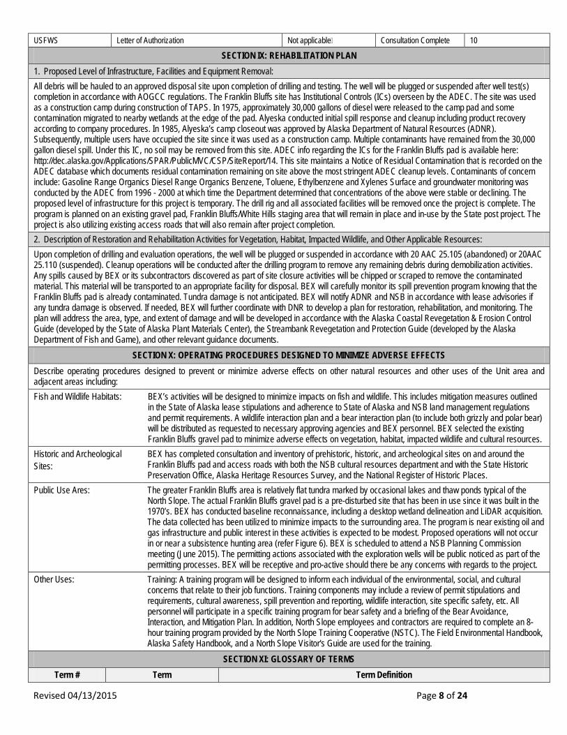
USFWS Letter of Authorization Not applicable Consultation Complete 10
SECTION IX: REHABILITATION PLAN 1. Proposed Level of Infrastructure, Facilities and Equipment Removal: All debris will be hauled to an approved disposal site upon completion of drilling and testing. The well will be plugged or suspended after well test(s) completion in accordance with AOGCC regulations. The Franklin Bluffs site has Institutional Controls (ICs) overseen by the ADEC. The site was used as a construction camp during construction of TAPS. In 1975, approximately 30,000 gallons of diesel were released to the camp pad and some contamination migrated to nearby wetlands at the edge of the pad. Alyeska conducted initial spill response and cleanup including product recovery according to company procedures. In 1985, Alyeska’s camp closeout was approved by Alaska Department of Natural Resources (ADNR). Subsequently, multiple users have occupied the site since it was used as a construction camp. Multiple contaminants have remained from the 30,000 gallon diesel spill. Under this IC, no soil may be removed from this site. ADEC info regarding the ICs for the Franklin Bluffs pad is available here: http://dec.alaska.gov/Applications/SPAR/PublicMVC/CSP/SiteReport/14. This site maintains a Notice of Residual Contamination that is recorded on the ADEC database which documents residual contamination remaining on site above the most stringent ADEC cleanup levels. Contaminants of concern include: Gasoline Range Organics Diesel Range Organics Benzene, Toluene, Ethylbenzene and Xylenes Surface and groundwater monitoring was conducted by the ADEC from 1996 - 2000 at which time the Department determined that concentrations of the above were stable or declining. The proposed level of infrastructure for this project is temporary. The drill rig and all associated facilities will be removed once the project is complete. The program is planned on an existing gravel pad, Franklin Bluffs/White Hills staging area that will remain in place and in-use by the State post project. The project is also utilizing existing access roads that will also remain after project completion. 2. Description of Restoration and Rehabilitation Activities for Vegetation, Habitat, Impacted Wildlife, and Other Applicable Resources: Upon completion of drilling and evaluation operations, the well will be plugged or suspended in accordance with 20 AAC 25.105 (abandoned) or 20AAC 25.110 (suspended). Cleanup operations will be conducted after the drilling program to remove any remaining debris during demobilization activities. Any spills caused by BEX or its subcontractors discovered as part of site closure activities will be chipped or scraped to remove the contaminated material. This material will be transported to an appropriate facility for disposal. BEX will carefully monitor its spill prevention program knowing that the Franklin Bluffs pad is already contaminated. Tundra damage is not anticipated. BEX will notify ADNR and NSB in accordance with lease advisories if any tundra damage is observed. If needed, BEX will further coordinate with DNR to develop a plan for restoration, rehabilitation, and monitoring. The plan will address the area, type, and extent of damage and will be developed in accordance with the Alaska Coastal Revegetation & Erosion Control Guide (developed by the State of Alaska Plant Materials Center), the Streambank Revegetation and Protection Guide (developed by the Alaska Department of Fish and Game), and other relevant guidance documents.
SECTION X: OPERATING PROCEDURES DESIGNED TO MINIMIZE ADVERSE EFFECTS Describe operating procedures designed to prevent or minimize adverse effects on other natural resources and other uses of the Unit area and adjacent areas including: Fish and Wildlife Habitats: BEX’s activities will be designed to minimize impacts on fish and wildlife. This includes mitigation measures outlined
in the State of Alaska lease stipulations and adherence to State of Alaska and NSB land management regulations and permit requirements. A wildlife interaction plan and a bear interaction plan (to include both grizzly and polar bear) will be distributed as requested to necessary approving agencies and BEX personnel. BEX selected the existing Franklin Bluffs gravel pad to minimize adverse effects on vegetation, habitat, impacted wildlife and cultural resources.
Historic and Archeological Sites:
BEX has completed consultation and inventory of prehistoric, historic, and archeological sites on and around the Franklin Bluffs pad and access roads with both the NSB cultural resources department and with the State Historic Preservation Office, Alaska Heritage Resources Survey, and the National Register of Historic Places.
Public Use Ares: The greater Franklin Bluffs area is relatively flat tundra marked by occasional lakes and thaw ponds typical of the North Slope. The actual Franklin Bluffs gravel pad is a pre-disturbed site that has been in use since it was built in the 1970’s. BEX has conducted baseline reconnaissance, including a desktop wetland delineation and LiDAR acquisition. The data collected has been utilized to minimize impacts to the surrounding area. The program is near existing oil and gas infrastructure and public interest in these activities is expected to be modest. Proposed operations will not occur in or near a subsistence hunting area (refer Figure 6). BEX is scheduled to attend a NSB Planning Commission meeting (June 2015). The permitting actions associated with the exploration wells will be public noticed as part of the permitting processes. BEX will be receptive and pro-active should there be any concerns with regards to the project.
Other Uses: Training: A training program will be designed to inform each individual of the environmental, social, and cultural concerns that relate to their job functions. Training components may include a review of permit stipulations and requirements, cultural awareness, spill prevention and reporting, wildlife interaction, site specific safety, etc. All personnel will participate in a specific training program for bear safety and a briefing of the Bear Avoidance, Interaction, and Mitigation Plan. In addition, North Slope employees and contractors are required to complete an 8-hour training program provided by the North Slope Training Cooperative (NSTC). The Field Environmental Handbook, Alaska Safety Handbook, and a North Slope Visitor's Guide are used for the training.
SECTION XI: GLOSSARY OF TERMS Term # Term Term Definition

Revised 04/13/2015 Page 9 of 24
N/A N/A N/A Enter Term #. Enter Term. Enter Term Definition. Enter Term #. Enter Term. Enter Term Definition. Enter Term #. Enter Term. Enter Term Definition. Enter Term #. Enter Term. Enter Term Definition. Enter Term #. Enter Term. Enter Term Definition. Enter Term #. Enter Term. Enter Term Definition. Enter Term #. Enter Term. Enter Term Definition. Enter Term #. Enter Term. Enter Term Definition. Enter Term #. Enter Term. Enter Term Definition.
SECTION XII: CONFIDENTIALITY The undersigned hereby requests that each page/section of this application marked confidential be held confidential under AS 38.05.035(a)(8). APPLICANT CONTACT: N/A
N/A
N/A
N/A
Signature Name Title Date

Revised 04/13/2015 Page 10 of 24
APPENDIX A: MAPS
Revised 04/13/2015 Page 11 of 24

Revised 04/13/2015 Page 12 of 24

Revised 04/13/2015 Page 13 of 24

Revised 04/13/2015 Page 14 of 24

Revised 04/13/2015 Page 15 of 24

Revised 04/13/2015 Page 16 of 24
APPENDIX B: MITIGATION MEASURES
North Slope Foothills
Company Analysis/Response A. Mitigation Measures
1. Facilities and operations
a. A plan of operations must be submitted and approved before conducting exploration, development or production activities, and must describe the lessee’s efforts to minimize impacts on residential, commercial, and recreational areas, Native allotments and subsistence use areas. At the time of application, lessee must submit a copy of the proposed plan of operations to all surface owners whose property will be entered.
A.1.a. Satisfied. A Plan of Operation is being submitted to ADNR for BEX oil and gas exploration project. Preparation for exploration activities are proposed to begin in July, 2015. There are no residential, commercial, and recreational areas, Native allotments and subsistence use areas. Alyeska Pipeline Service Company (APSC) is a holder of a significant surface interest in the project area, and BEX will provide a copy of the proposed Plan of Operation to APSC and coordinate accordingly.
b. Facilities must be designed and operated to minimize sight and sound impacts in areas of high residential, commercial, recreational, and subsistence use and important wildlife habitat. Methods may include providing natural buffers and screening to conceal facilities, sound insulation of facilities, or by using alternative means approved by the Director, in consultation with ADF&G and the NSB.
A.1.b. Satisfied. There are no residential areas in the proposed project area. The project is located on mile marker 39 of the haul road and on the existing Franklin Bluffs gravel pad; BEX considers this pad an industrial area. Recreational hunting with bow and arrow is allowed in the greater area but BEX does not believe that the proposed project area is characterized as an area of high use for such activities. BEX chose the Franklin Bluffs pad to minimize impacts to subsistence users and to important wildlife habitat. Access to the drill location is on an existing gravel road and will be restricted to authorized visitors and personnel only.
c. To the extent practicable, the siting of facilities will be prohibited within 500 feet of all fish-bearing streams and waterbodies and 1,500 feet from all current surface drinking water sources. Additionally, to the extent practicable, the siting of facilities will be prohibited within one-half mile of the banks of the main channel of the Colville, Canning, Sagavanirktok, Kavik, Shaviovik, Kadleroshilik, Echooka, Ivishak, Kuparuk, Toolik, Anaktuvuk and Chandler Rivers. Facilities may be sited within these buffers if the lessee demonstrates to the satisfaction of the Director, in consultation with ADF&G, that site locations outside these buffers are not practicable or that a location inside the buffer is environmentally preferred. Road, utility, and pipeline crossings must be consolidated and aligned perpendicular or near perpendicular to watercourses.
A.1.c. Satisfied. The proposed Icewine #1 drill site is not within 500 feet of a fish-bearing stream, or 1,500 feet of a current drinking water source. The Icewine #1 project is not within the ½ mile buffer from the main channel of the Sagavanirktok River (the closest river in the list provided in c).
d. No facilities will be sited within one-half mile of identified Dolly Varden overwintering and/or spawning areas on the Canning, Shaviovik, and Kavik rivers. Notwithstanding the previous sentence, road and pipeline crossings may only be sited within these buffers if the lessee demonstrates to the satisfaction of the Director and ADF&G in the course of obtaining their respective permits, that either (1) the scientific data indicate the proposed crossing is not within an overwintering and/or spawning area; or (2) the proposed road or pipeline crossing will have no significant adverse impact to Dolly Varden overwintering and/or spawning habitat.
A.1.d. Not applicable. The Icewine #1 project is not near the Canning, Shaviovik, and Kavik rivers.
e. Impacts to important wetlands must be minimized to the satisfaction of the Director, in consultation with ADF&G and ADEC. The Director will consider whether facilities are sited in the least sensitive areas. Further, all activities within wetlands require permission from the US
A.1.e. Not Applicable. BEX is conducting this exploration activity from the existing Franklin Bluffs pad and existing gravel access roads, therefore, no wetlands will be impacted as part of this project. BEX will consult with the US Army Corps of Engineers during pre-application

Revised 04/13/2015 Page 17 of 24
Army Corps of Engineers (see Lessee Advisories). meetings for potential wetland issues.
f. Exploration facilities, including exploration roads and pads, must be temporary and must be constructed of ice unless the Director determines that no practicable alternative exists. Re-use of abandoned gravel structures may be permitted on a case-by-case basis by the Director, after consultation with the director, DMLW, and ADF&G. Approval for use of abandoned structures will depend on the extent and method of restoration needed to return these structures to a usable condition.
A.1.f. Satisfied. BEX has planned to use the existing Franklin Bluffs gravel pad and gravel access roads and will consult with the director, DMLW, and ADF&G for approval.
g. Pipelines must utilize existing transportation corridors where conditions permit. Pipelines must be designed to facilitate the containment and cleanup of spilled fluids. Where practicable, onshore pipelines must be located on the upslope side of roadways and construction pads, unless the director, DMLW, determines that an alternative site is environmentally acceptable. Wherever possible, onshore pipelines must utilize existing transportation corridors and be buried where soil and geophysical conditions permit. All pipelines, including flow and gathering lines, must be designed, constructed and maintained to assure integrity against climatic conditions, geophysical hazards, corrosion and other hazards as determined on a case-by-case basis.
A.1.g. Not Applicable. No pipelines associated with the 2015 Icewine #1 project.
h. Pipelines shall be designed and constructed to avoid significant alteration of caribou and other large ungulate movement and migration patterns. At a minimum, above-ground pipelines shall be elevated 7 feet, as measured from the ground to the bottom of the pipe, except where the pipeline intersects a road, pad, or a ramp installed to facilitate wildlife passage. Lessees shall consider increased snow depth in the sale area in relation to pipe elevation to ensure adequate clearance for wildlife. ADNR may, after consultation with ADF&G, require additional measures to mitigate impacts to wildlife movement and migration.
A.1.h. Not Applicable. No pipelines associated with the 2015 Icewine #1 project.
i. The state of Alaska discourages the use of continuous-fill causeways. Environmentally preferred alternatives for field development include use of buried pipelines, onshore directional drilling, or elevated structures. Approved causeways must be designed, sited, and constructed to prevent significant changes to nearshore oceanographic circulation patterns and water quality characteristics (e.g., salinity, temperature, suspended sediments) that result in exceedances of water quality criteria, and must maintain free passage of marine and anadromous fish.
ii. Causeways and docks shall not be located in river mouths or deltas. Artificial gravel islands and bottom founded structures shall not be located in river mouths or active stream channels on river deltas, except as provided for in (iii).
iii. Each proposed structure will be reviewed on a case-by-case basis. Causeways, docks, artificial gravel islands and bottom founded structures may be permitted if the Director, in consultation with ADF&G, ADEC, and the NSB determines that a causeway or other structures are necessary for field development and that no practicable alternatives exist. A monitoring program may be required to address the objectives of water quality and free passage of fish, and mitigation shall be required where significant deviation from objectives occurs. (See also Lessee Advisories regarding U.S. Army
A.1.i. Not Applicable. No causeways or docks associated with the 2015 Icewine #1 project.
Revised 04/13/2015 Page 18 of 24
Corps of Engineers requirements.)
j. Dismantlement, Removal and Rehabilitation (DR&R): Upon abandonment of material sites, drilling sites, roads, buildings or other facilities, such facilities must be removed and the site rehabilitated to the satisfaction of the Director, unless the Director, in consultation with DMLW, ADF&G, ADEC, NSB, and any non-state surface owner, determines that such removal and rehabilitation is not in the state’s interest.
A.1.j. Mitigation measure will be met. See Rehabilitation section of the Plan of Operation. No material sites will be utilized, and drilling sites, roads, buildings or other facilities, will be removed and the site rehabilitated to the satisfaction of the Director.
k. Gravel mining sites required for exploration and development activities will be restricted to the minimum necessary to develop the field efficiently and with minimal environmental damage. Where practicable, gravel sites must be designed and constructed to function as water reservoirs for future use. Gravel mine sites required for exploration activities must not be located within an active floodplain of a watercourse unless the director, DMLW, after consultation with ADF&G, determines that there is no practicable alternative, or that a floodplain site would enhance fish and wildlife habitat after mining operations are completed and the site is closed. Mine site development and rehabilitation within floodplains must follow the procedures outlined in McLean, R. F. 1993, North Slope Gravel Pit Performance Guidelines, ADF&G Habitat and Restoration Division Technical Report 93-9, available from ADF&G.
A.1.k. Not Applicable. There are no new gravel mine sites associated with the 2015 Icewine #1 project.
2. Fish and Wildlife Habitat
a. Detonation of explosives within or in proximity to fish-bearing waters must not produce instantaneous pressure changes that exceed 2.7 pounds per square inch in the swim bladder of a fish. Detonation of explosives within or in close proximity to a fish spawning bed during the early stages of egg incubation must not produce a peak particle velocity greater than 0.5 inches per second. Blasting criteria have been developed by ADF&G and are available upon request from ADF&G. The location of known fish-bearing waters within the project area can also be obtained from ADF&G. The lessee will consult with the NSB prior to proposing the use of explosives for seismic surveys. The Director may approve the use of explosives for seismic surveys after consultation with the NSB
A.2.a. Not Applicable. There are no explosives being detonated as part of the 2015 Icewine #1 project.
b. Water intake pipes used to remove water from fish-bearing waterbodies must be surrounded by a screened enclosure to prevent fish entrainment and impingement. Screen mesh size shall be no greater than 1 mm (0.04 inches), unless another size has been approved by ADF&G. The maximum water velocity at the surface of the screen enclosure may be no greater than 0.1 foot per second, unless an alternative velocity has been approved by ADF&G.
A.2.b. Mitigation measure will be met. Water withdrawals associated with the 2015 Icewine #1 project are currently anticipated from five water sources. Should any of these water withdrawal be classified as a fish bearing waterbody, sufficient water intake pipes will be used to prevent fish entrainment and impingement.
c. Removal of snow from fish-bearing rivers, streams and natural lakes shall be subject to prior written approval by ADF&G. Compaction of snow cover overlying fish-bearing waterbodies is prohibited except for approved crossings. If ice thickness is not sufficient to facilitate a crossing, ice or snow bridges may be required.
A.2.c. Mitigation measure will be met. Compaction of snow cover overlying fish bearing waterbodies may occur as necessary to place temporary pump houses over permitted temporary water use locations.
d. Bears: i. Before commencement of any activities, lessees shall consult
with ADF&G (907-459-7213) to identify the locations of known brown bear den sites that are occupied in the season of proposed activities. Exploration and production activities must not be conducted within one-half mile of occupied brown bear dens, unless alternative mitigation measures are approved by
A.2.d. Satisfied. BEX has completed communication with ADF&G regarding the locations of known brown bear dens sites near the Franklin Bluffs pad. As a result of this communication, there are no known brown bear den sites of concern. BEX has created a Bear Avoidance, Interaction, Mitigation, and Monitoring Plan and will provide to the Division of Oil and Gas upon request.

Revised 04/13/2015 Page 19 of 24
ADF&G. A lessee who encounters an occupied brown bear den not previously identified by ADF&G must report it to the Division of Wildlife Conservation, ADF&G, within 24 hours. Mobile activities shall avoid such discovered occupied dens by one-half mile unless alternative mitigation measures are approved by the Director, with concurrence from ADF&G. Non-mobile facilities will not be required to relocate.
i. Before commencement of any activities, lessees shall consult with the USFWS (907-786-3800) to identify the locations of known polar bear den sites. Operations must avoid known polar bear dens by 1 mile. A lessee who encounters an occupied polar bear den not previously identified by USFWS must report it to the USFWS within 24 hours and subsequently avoid the new den by 1 mile. If a polar bear should den within an existing development, off-site activities shall be restricted to minimize disturbance.
ii. For projects in proximity to areas frequented by bears, lessees are required to prepare and implement a human-bear interaction plan designed to minimize conflicts between bears and humans. The plan should include measures to: A. minimize attraction of bears to facility sites; B. organize layout of buildings and work areas to minimize
interactions between humans and bears; C. warn personnel of bears near or on facilities and the proper
actions to take; D. if authorized, deter bears from the drill site; E. provide contingencies in the event bears do not leave the
site; F. discuss proper storage and disposal of materials that may
be toxic to bears; and provide a systematic record of bears on the site and in the immediate area.
e. Permanent, staffed facilities must be sited to the extent practicable outside identified brant, white-fronted goose, snow goose, tundra swan, king eider, common eider, Steller’s eider, spectacled eider, and yellow-billed loon nesting and brood rearing areas.
A.2.e. Not Applicable. There are no permanent facilities associated with the Icewine #1 project.
3. Subsistence, Commercial and Sport Harvest Activities
a. i. Exploration, development and production operations shall be conducted in a manner that prevents unreasonable conflicts between lease-related activities and subsistence activities. Lease-related use will be restricted when the Director determines it is necessary to prevent conflicts with local subsistence, commercial and sport harvest activities. In enforcing this term DO&G will consult with other agencies, the affected local borough(s) and the public to identify and avoid potential conflicts that are brought to the division’s attention both in the planning and operational phases of lease-related activities. In order to avoid conflicts with subsistence, commercial and sport harvest activities, restrictions may include alternative site selection, requiring directional drilling, seasonal drilling restrictions, and other technologies deemed appropriate by the Director.
ii. Prior to submitting a plan of operations for either onshore or offshore activities which have the potential to disrupt subsistence activities, the lessee shall consult with the potentially affected subsistence communities and the NSB (collectively “parties”) to discuss the siting, timing, and methods of proposed operations and safeguards or mitigating measures which could be implemented by the operator to prevent unreasonable conflicts. The parties shall also
A.3.a.i. Mitigation measure will be met. BEX understands the subsistence interests of local residents. BEX has conducted a pre-application meeting and is scheduled for anther with the NSB prior to its proposed activities under the Icewine #1 project.
A.3.a.ii. Mitigation measure will be met. BEX will work together with the Director to prevent conflicts with local subsistence, commercial and sport harvest activities.
A.3.a.iii. Mitigation measure will be met. BEX will document discussion or agreements reached or not reached during Borough consultation process.
A.3.a.iv. Mitigation measure will be met. The project is not within a subsistence use area (refer Figure 6).
Revised 04/13/2015 Page 20 of 24
discuss the reasonably foreseeable effect on subsistence activities of any other operations in the area that they know will occur during the lessee’s proposed operations. Through this consultation, the lessee shall make reasonable efforts to assure that exploration, development, and production activities are compatible with subsistence hunting and fishing activities and will not result in unreasonable interference with subsistence harvests.
iii. A discussion of agreements reached or not reached during the consultation process and any plans for continued consultation shall be included in the plan of operations. The lessee shall identify who participated in the consultation and send copies of the plan to participating communities and the NSB when it is submitted to the division.
iv. If the parties cannot agree, then any of them may request the Commissioner of DNR or his/her designee to intercede. The commissioner may assemble the parties or take other measures to resolve conflicts among the parties.
v. The lessee shall notify the Director of all concerns expressed by subsistence hunters during operations and of steps taken to address such concerns.
A.3.a.v. Mitigation measure will be met.
b. Traditional and customary access to subsistence areas shall be maintained unless reasonable alternative access is provided to subsistence users. “Reasonable access” is access using means generally available to subsistence users. Lessees will consult the NSB, nearby communities, and native organizations for assistance in identifying and contacting local subsistence users.
A.3.b. Mitigation measure will be met. Access to subsistence areas should not be affected by the activities under the Icewine #1 project.
4. Fuel, Hazardous Substances and Waste
a. Secondary containment shall be provided for the storage of fuel or hazardous substances.
A.4.a. Mitigation measure will be met. See description on the proposed operations, including the location and design of Fuel and Hazardous Substances in the Plan of Operation for more information.
b. Containers with an aggregate storage capacity of greater than 55 gallons which contain fuel or hazardous substances shall not be stored within 100 feet of a waterbody, or within 1,500 feet of a current surface drinking water source.
A.4.b. Mitigation measure will be met. See description on the proposed operations, including the location and design of Fuel and Hazardous Substances in the Plan of Operation for more information.
c. During equipment storage or maintenance, the site shall be protected from leaking or dripping fuel and hazardous substances by the placement of drip pans or other surface liners designed to catch and hold fluids under the equipment, or by creating an area for storage or maintenance using an impermeable liner or other suitable containment mechanism.
A.4.c. Mitigation measure will be met. See description on the proposed operations, including the location and design of Fuel and Hazardous Substances in the Plan of Operation for more information.
d. During fuel or hazardous substance transfer, secondary containment or a surface liner must be placed under all container or vehicle fuel tank inlet and outlet points, hose connections, and hose ends. Appropriate spill response equipment, sufficient to respond to a spill of up to five gallons, must be on hand during any transfer or handling of fuel or hazardous substances. Trained personnel shall attend
A.4.d. Mitigation measure will be met. See description on the proposed operations, including the location and design of Fuel and Hazardous Substances in the Plan of Operation for more information.

Revised 04/13/2015 Page 21 of 24
transfer operations at all times.
e. Vehicle refueling shall not occur within the annual floodplain, except as addressed and approved in the plan of operations. This measure does not apply to water-borne vessels.
A.4.e. Request Waiver/Exception. As outlined in the Plan of Operation description in the location and design of Fuel and Hazardous Substances, vehicle refueling to support the project would occur in the Sag River floodplain.
f. All independent fuel and hazardous substance containers shall be marked with the contents and the lessee’s or contractor’s name using paint or a permanent label.
A.4.f. Mitigation measure will be met. See description on the proposed operations, including the location and design of Fuel and Hazardous Substances in the Plan of Operation for more information.
g. A fresh water aquifer monitoring well, and quarterly water quality monitoring, is required down gradient of a permanent storage facility, unless alternative acceptable technology is approved by ADEC.
A.4.g. Not Applicable. There are no permanent facilities associated with the Icewine #1 project.
h. Waste from operations must be reduced, reused, or recycled to the maximum extent practicable. Garbage and domestic combustibles must be incinerated whenever possible or disposed of at an approved site in accordance with 18 AAC 60. (See Lessee Advisories, ADEC.)
A.4.h. Mitigation measure will be met. See description on the proposed operations, including the location and design of Solid Waste Sites in the Plan of Operation for more information.
i. New solid waste disposal sites, other than for drilling waste, will not be approved or located on state property during the exploration phase of lease activities. Disposal sites may be provided for drilling waste if the facility complies with 18 AAC 60. (See Lessee Advisories, ADEC.)
A.4.i. Not Applicable. No new solid waste disposal sites will be created as part of the Icewine #1 project. BEX plans to use the NSB SA-10 landfill.
j. The preferred method for disposal of muds and cuttings from oil and gas activities is by underground injection. Drilling mud and cuttings cannot be discharged into lakes, streams, rivers, or important wetlands. On pad temporary cuttings storage will be allowed as necessary to facilitate annular injection and/or backhaul operations. Impermeable lining and diking, or equivalent measures, will be required for reserve pits. Surface discharge of drilling muds and cuttings into reserve pits shall be allowed only when the Director, in consultation with ADF&G, determines that alternative disposal methods are not practicable. Injection of non-hazardous oilfield wastes is regulated by AOGCC through its Underground Injection Control (UIC) Program for oil and gas wells. See also Mitigation Measure 8.a.vi.
A.4.j. Mitigation measure will be met. See description on the proposed operations, including the location and design of Solid Waste Sites in the Plan of Operation for more information.
k. Proper disposal of garbage and putrescible waste is essential to minimize attraction of wildlife. The lessee must use the most appropriate and efficient method to achieve this goal. The primary method of garbage and putrescible waste is prompt, on-site incineration in compliance with state of Alaska air quality regulations. The secondary method of disposal is on-site frozen storage in animal-proof containers with backhaul to an approved waste disposal facility. The tertiary method of disposal is on-site non-frozen storage in animal proof containers with backhaul to an approved waste disposal facility. Daily backhauling of non-frozen waste must be achieved unless safety considerations prevent it.
A.4.k. Mitigation measure will be met. See description on the proposed operations, including the location and design of Solid Waste Sites in the Plan of Operation for more information.
5. Access
a. Except for approved off-road travel, exploration activities must be supported only by ice roads, winter trails, existing road systems or air service. Wintertime off-road travel across tundra and wetlands may be approved in areas where snow and frost depths are sufficient to protect the ground surface. Summertime off-road travel across tundra and wetlands may be authorized subject to time periods and vehicle types approved by DMLW. Exceptions may be granted by the
A.5.a. Satisfied/Not Applicable. BEX is conducting this exploration activity from the existing Franklin Bluffs pad and existing access roads, therefore, no wetlands will be impacted as part of this project.
Revised 04/13/2015 Page 22 of 24
director of the DMLW, and the Director, if an emergency condition exists; or, if it is determined, after consulting with ADF&G that travel can be accomplished without damaging vegetation or the ground surface. Exceptions, including the use of gravel, may also be granted on a site specific basis, if it is determined, after consulting with ADF&G and DMLW, that no practicable alternatives exist for constructing an exploration road or pad in the area south of the boundary described below and depicted in the map below: Figure 7.1: Gravel Consideration Boundary Beginning at the NPR-A boundary, from the northeast corner of T 1N, R 2E, east to the northwest corner of T 1N, R 9E, then north to the northwest corner of T 4N, R 9E, then east to the northwest corner of T 4N, R 23E, then south to the southwest corner of T 4N, R 23E, and then east along the top of T 3N to the ANWR boundary.
b. Public access to, or use of, the lease area may not be restricted except within the immediate vicinity of drill sites, buildings, and other related facilities. Areas of restricted access must be identified in the plan of operations. Lease facilities and operations shall not be located so as to block access to or along navigable or public waters as defined in AS 38.05.
A.5.b. Mitigation measure will be met. The Icewine #1 project will only result in restrictions to public access surrounding the drilling rig, camp, and associated buildings on the Franklin Bluffs pad for safety reasons. No other restrictions to public access will result from the Icewine #1 project.
6. Prehistoric, Historic, and Archeological Sites
a. Prior to the construction or placement of any structure, road, or facility resulting from exploration, development, or production activities, the lessee must conduct an inventory of prehistoric, historic, and archeological sites within the area affected by an activity. The inventory must include consideration of literature provided by the NSB, nearby communities, Native organizations, and local residents; documentation of oral history regarding prehistoric and historic uses of such sites; evidence of consultation with the Alaska Heritage Resources Survey and the National Register of Historic Places; and site surveys. The inventory must also include a detailed analysis of the effects that might result from the activity.
A.6.a. Satisfied. BEX has obtained cultural clearance from the State of Alaska, State Historic Preservation Office North Slope Borough cultural resources department on potential historical, and archaeological resources. Because of the history and long-term use of the Franklin Bluffs pad, no sites are anticipated that would impact cultural, historical, or archaeological resources.
b. The inventory of prehistoric, historic, and archeological sites must be submitted to the Director, and to SHPO who will coordinate with the NSB for review and comment. If a prehistoric, historic, or archeological site or area could be adversely affected by a lease activity, the Director, after consultation with SHPO and the NSB, will direct the lessee as to the course of action to take to avoid or minimize adverse effects.
A.6.b. Satisfied.
c. If a site, structure, or object of prehistoric, historic, or archaeological significance is discovered during lease operations, the lessee must report the discovery to the Director as soon as possible. The lessee must make reasonable efforts to preserve and protect the discovered site, structure, or object from damage until the Director, after consultation with the SHPO and the NSB, has directed the lessee as to the course of action to take for its preservation.
A.6.c. Mitigation measure will be met.
7. Local Hire, Communication, and Training
a. Lessees are encouraged to employ local and Alaska residents and contractors, to the extent they are available and qualified, for work performed in the lease area. Lessees shall submit, as part of the plan of operations, a proposal detailing the means by which the lessee will comply with the measure. The proposal must include a description of the operator’s plans for partnering with local communities to recruit, hire and train local and Alaska residents and contractors. The lessee is encouraged, in formulating this proposal, to coordinate with
A.7.a. Mitigation measure will be met. Local representatives may support BEX operations during the program. BEX will strive to employ Alaskan residents and contractors in their operations. BEX will make the hiring of local Alaskans a priority in the planning process.

Revised 04/13/2015 Page 23 of 24
employment and training services offered by the State of Alaska and local communities to train and recruit employees from local communities.
b. A plan of operations application must describe the lessee’s past and prospective efforts to communicate with local communities and interested local community groups.
A.7.b. Mitigation measure will be met.
c. A plan of operations application must include a training program for all personnel including contractors and subcontractors. The program must be designed to inform each person working on the project of environmental, social, and cultural concerns that relate to that person’s job. The program must use methods to ensure that personnel understand and use techniques necessary to preserve geological, archeological, and biological resources. In addition, the program must be designed to help personnel increase their sensitivity and understanding of community values, customs, and lifestyles in areas where they will be operating.
A.7.c. Mitigation measure will be met. See Section X, Training.
8. Definitions
a. In this document: i. “Facilities” means any structure, equipment, or improvement to the surface, whether temporary or permanent, including, but not limited to, roads, pads, pits, pipelines, power lines, generators, utilities, airstrips, wells, compressors, drill rigs, camps and buildings; ii. “Important wetlands” means those wetlands that are of high value to fish, waterfowl, and shorebirds because of their unique characteristics or scarcity in the region or that have been determined to function at a high level using the hydrogeomorphic approach; iii. “Minimize” means to reduce adverse impacts to the smallest amount, extent, duration, size, or degree reasonable in light of the environmental, social, or economic costs of further reduction; iv. “Plan of operations” means a lease Plan of operations under 11 AAC 83.158 and a unit Plan of operations under 11 AAC 83.346; v. “Practicable” means feasible in light of overall project purposes after considering cost, existing technology, and logistics of compliance with the standard; vi. “Secondary containment” means an impermeable diked area or portable impermeable containment structure capable of containing 110 percent of the volume of the largest independent container plus 12 inches of freeboard. Double walled tanks do not qualify as Secondary Containment unless an exception is granted for a particular tank. vii. “Temporary” means no more than 12 months.
A.8.a. No response.

Revised 04/13/2015 Page 24 of 24
APPENDIX C: OTHER Additional Information to supplement “Section V) Land Status, and subsection 1) State mineral estate, Other considerations”. Additional ADL, surface ownership & access agreements overlapping and adjacent to ADL 392301:
• ADL 63574 - Alyeska Pipeline Service Company Pipeline Right-of-Way • ADL 63826 – Department of Transportation & Public Facilities Right-of-Way • ADL 403068, 414572 & 414573 - Alyeska Pipeline Service Company Private Easement • ADL 415408 – Department of Transportation & Public Facilities Management Agreement • ADL 418997 – Alaska Gasline Development Corporation, Alaska Stand-Alone Pipeline Right-of-Way • ADL 420360 – Alyeska Pipeline Service Company Potentially Hazardous Sites/Restricted Use • ADL 414835 – North Slope Borough Municipal Entitlement Land Under AS 29.65.01 • LAS 29599 – Incorporated Research Institution for Seismology (IRIS) DMLW miscellaneous (temporary) land use permit • LAS 29667 – Alaska Gasline Development Corporation, Alaska Stand-Alone Pipeline DMLW miscellaneous (temporary) land use permit • LAS 20031 – Department of Transportation & Public Facilities DMLW special land use permit under A.S. 38.05.850 • DNR Area – Northern Region • Regional Alaska Native Corporation – Arctic Slope Regional Corporation • State Information District – North Slope Borough • Coastal Zone – Yes (014 Cs, Sagavanirktok)