leaving no one behind - unstats.un.org 2... · business statistics other surveys: with government...
TRANSCRIPT

DIRECTORATE OF SURVEYS
Roberto Luís Olinto Ramos
Brazilian Institute of Geography and Statistics
Director of Surveys
Leaving no one behind
Identify the “ones”: a challenge to statistics
and geography
Global Preparatory Seminar for the United Nations World
Data Forum
7-9 September 2016, Guilin, China

leaving no one behind
? Identify the “ONES”.
Who are the people we want to reach with our
policies?
=> who – where – how
=> disagreggation: statistical and
geographical and registers
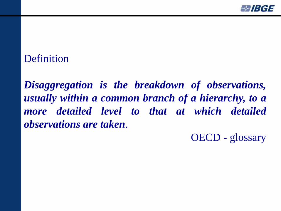
Definition
Disaggregation is the breakdown of observations,
usually within a common branch of a hierarchy, to a
more detailed level to that at which detailed
observations are taken.
OECD - glossary

Disaggregation
( a very simple view, however useful)
Variable X
X1
X11
X111
…........
X12
X2
Tree
Structure

Break for a epistemogical reasoning
or
wishful thinking :
It is important to keep in mind there is a tradeoff
between the reality and our capacity to measure it.
Descartes, Kant, Heisenberg and others

Challenges (some of then)
1. Classifications – hierarchy.
2. Geographical scope – Global Regional
National Indicators (SDGs).
3. Comparability (SDGs) time and space.
4. Confidentiality (statistical and geographical)
5. Political, social, cultural environment.
6. Direct x Indirect Methods (statistics x
modeling)

Households
• Household survey
• Expenditure survey
• Census: Population and Agriculture
• Special surveys
Registers – civil register, fiscal data…..
Business statistics
Other surveys: with government, schools,
hotels…..
Brazilian surveys

Brazil
Population census
2000 2010 2020

Universo
Amostra
Amostra
Amostra
Universo
Universo
Universo
Amostra
Amostra
Amostra
Universo
Universo
Universo
Universo
Universo
Universo
Amostra
Universo
Universo
Universo
Amostra
Amostra
Universo
Características Investigadas no Censo
B.Características de migração internacional
C.Características do domicílio e da família
Fonte da
Informação
Aquisição de cidadania
Ano ou período de chegada
Lugar da residência anterior
A. Características geográficas e migração internaLugar de residência habitual
Lugar de nascimento
D.Características sociais e demográficasStatus do domicílio e da família ( Grau de parentesco, classificação)
Sexo
Idade
Lugar de residência em um período específico no passado
Total de população
Localidade
Divisão em urbano e rural
Nível mais Baixo
de DesagregaçãoSetor Censitário
Área de Ponderação
Área de Ponderação
Área de Ponderação
Setor Censitário
Área de Ponderação
Área de Ponderação
Área de Ponderação
Área de Ponderação
Área de Ponderação
Religião
Língua
Etnia
País de nascimento
Tem mãe viva
Tem registro de nascimento
Relação com a pessoa de referência do domicílio
Composição do domicílio e da família
Povos indígenas
Condição de incapacidade ( Deficiência)
Estado civil
Área de Ponderação
Setor Censitário
Setor Censitário
Setor Censitário
Setor Censitário
Setor Censitário
Setor Censitário
Setor Censitário
Setor Censitário
Setor Censitário
Setor Censitário
Setor Censitário
Setor Censitário
Disaggregation in population census
Universe
Sample

Amostra
Amostra
Amostra
Universo
Amostra
Universo
Amostra
Amostra
Amostra
Amostra
Amostra
Amostra
Amostra
Amostra
Amostra
Amostra
Amostra
Universo
Amostra
Amostra
Amostra
Amostra
Amostra
Características Investigadas no CensoFonte da
Informação
Nível mais Baixo
de DesagregaçãoE.Fecundidade e mortalidade
Mortes no domicílio nos últimos 12 meses
Ocupação
Lugar de trabalho
Setor institucional do emprego ( Atividade)
Horas trabalhadas
H.Agricultura
Participação na produção para uso próprio de mercadorias
Rendimento
Deslocamento para trabalho
Quantidade de trabalhos
Quantidade de pessoas empregadas no trabalho
ontribuinte de instituto de previdência oficial
F.Características educacionais
Produção agrícola por conta prórpria
Alfabetização
Frequência escolar
Nível de instrução
Área de educação, treinamento e qualificações educacionais
G.Características econômicas
Situação na ocupação/trabalho
Condição da força de trabalho
Quantos filhos e filhas nascidos mortos teve.....?
Deslocamento para estudo
Filhos nascidos vivos
Filhos vivos
Data de nascimento do último filho nascido vivo
Área de Ponderação
Área de Ponderação
Área de Ponderação
Área de Ponderação
Área de Ponderação
Área de Ponderação
Área de Ponderação
Área de Ponderação
Área de Ponderação
Área de Ponderação
Área de Ponderação
Área de Ponderação
Setor Censitário
Setor Censitário
Área de Ponderação
Área de Ponderação
Área de Ponderação
Área de Ponderação
Área de Ponderação
Setor Censitário
Área de Ponderação
Área de Ponderação
Área de Ponderação
Desagregação no Censo

Universo
Universo
Universo
Universo
Amostra
Amostra
Universo
Universo
Universo
Universo
Universo
Universo
Universo
Amostra
Universo
Universo
Amostra
Amostra
Amostra
Características Investigadas no CensoFonte da
Informação
Nível mais Baixo
de Desagregação
Forma de coleta de esgoto
Tópicos de censo de domicílios
Tipo dos domicílios
Localização dos domicílios
Status de ocupação (Espécie)
Forma de propriedade
Número de cômodos
Número de quartos
Sistema de abastecimento de água
Tipo de banheiro
Tipo de prédio
Principal forma de coleta dos resíduos sólidos (lixo domiciliar)
Tipo de iluminação e/ou eletricidade
Número de moradores
Custos de aluguel e habitação
Material utilizado na construção das paredes externas
Estabelecimento agrícola
Idade e sexo da pessoa de referência do domicílio
Disponibilidade de dispositivos de informação e comunicação (rádio..celular....)
Disponibilidade de bens duráveis
Setor Censitário
Setor Censitário
Setor Censitário
Setor Censitário
Setor Censitário
Setor Censitário
Área de Ponderação
Área de Ponderação
Área de Ponderação
Setor Censitário
Setor Censitário
Setor Censitário
Setor Censitário
Setor Censitário
Setor Censitário
Setor Censitário
Área de Ponderação
Área de Ponderação
Área de Ponderação
Desagregação no Censo

Territorial disaggretation
Árvore de desagregação de divulgação do Censo : Amostra Árvore de desagregação de divulgação do Censo: Universo
Brasil Brasil
Grande Região Grande Região
Unidades da Federação Unidades da Federação
Mesorregião Geográfica Mesorregião Geográfica
Microrregião Geográfica Microrregião Geográfica
Municípios Municípios
Áreas de Ponderação Áreas de Ponderação (?)Distrito
Subdistrito
Bairro
Setor Censitário
Desagregações Especiais: Desagregações Especiais:
Região Metropolitana Região Metropolitana
Região Metropolitana e Subdivisão Região Metropolitana e Subdivisão
Região Integrada de Desenvolvimento Região Integrada de Desenvolvimento
Aglomeração Urbana Aglomeração Urbana
Arranjo Populacional
Terras Indígenas
Aglomerado Subnormal

Some experiences: theme x source
Colour or race

The IBGE has, since 1872, asking for colour and race in the
population census.
The colour categories , since 1991, are: branca, preta, parda,
amarela e indígena (white, black, “brown”, yellow and indigenous).
In the household survey the small effective of yellow and
indigenous (less than 2%), the indicators estimated are: white,
black and brown or black and white + brown. The union of the two
latter groups is justified by the socioeconomic proximity.


Data source: IBGE, PNAD Source: 3rd MDG national monitoring report, 2007.
White Black / Brown
Household survey => sampling

About population data
Registers (example: deceased) we can get colour or race data,
however this data has some statistical constraints
Colour or race: the identification is multidetermined: ancestry,
appearance, socialization, etc.
We must note the "self-identification principle” (human rights).

Age groups

Sampling surveys:
- Five-year periods - 0 a 4, 5 a 9, 10 a 14 ...
- Specific groups as childs and teens (0 to 14 years), young (15 to 29
years), elder (60 years and more), reprodutive period (15 to 49
years).
- simple age , ex. Less than 1 year.
- Specific age groups - ex: 15 to 17 years for education indicators
or elderly people 60 or more. However we should analyse the
sample.

Gender and sex

Gender
Cross-thematic studies on the social inequality in the IBGE. It implies a
relationship that is not limited to the breakdown between the sexes (men and
women).
Example: ratio between the income of men and women.
There are not studies to the inclusion of new gender identities in the
household survey.
• Sex
Basic breakdown, present in most of the indicators from census and
sample household surveys.
In IBGE concepts used for the category sex in census and household
surveys are: male and female
Same sex marriages
Only in population census 2010 we could get the variable: ”partner of
the same sex”. One way is the civil register who has the records of the
marriages.

Income and poverty

Data sources to income disaggregation:
Population census => reach municipaties:
Income: Total, from work, others sources – reference July;
Household Survey Annual: from 1981 to 2015 – states,
metropolitan areas, urban/rural
Income: Total, from work, others sources – reference Setember;
Household Survey Continuous (monthly, quarterly and
annual data) – since 2012 - states, metropolitan areas,
urban/rural.
Income from work monthly and annual for total and others
sources.
Income from the Expenditure Survey is more reliable
however without periodicity 2002-2003/2008-2009;
Income: Total, from work, others sources – reference 12
months

Land Use Change Assets
Geociencies Directorate

1. Artificial surfaces 8. Shrub-covered areas
2. Croplands (woody+herbaceous) 9. Shrub-covered areas permanently or regularly flooded
3. Artificial pasture (seeded grassland) 10. Natural pastures
4. Croplands with remaining forests 11. Mosaics of predominantly natural shublands and farming (crops or cattle)
5. Forestry 12. Inland water bodies
6. Forests 13. Coastal water bodies
7. Mosaics of predominantly forested areas and multiple or layered crops
14. Terrestrial barren land
Classes of Land Use and Cover

Legend cover and use of land 1 Artificial surfaces
2 Croplands (woody+herbaceous)
3 Artificial pasture (seeded grassland)
4 Croplands with remaining forests
5 Forestry
6 Forests
7 Mosaics of predominantly forested areas and multiple or layered crops
8 Shrub-covered areas
9 Shrub-covered areas permanently or regularly flooded
10 Natural pastures
11 Artificial surfaces
12 Inland water bodies
13 Coastal water bodies
14 Terrestrial barren land
Land Use and Land Cover - 2000

Legend cover and use of land 1 Artificial surfaces
2 Croplands (woody+herbaceous)
3 Artificial pasture (seeded grassland)
4 Croplands with remaining forests
5 Forestry
6 Forests
7 Mosaics of predominantly forested areas and multiple or layered crops
8 Shrub-covered areas
9 Shrub-covered areas permanently or regularly flooded
10 Natural pastures
11 Artificial surfaces
12 Inland water bodies
13 Coastal water bodies
14 Terrestrial barren land
Land Use and Land Cover - 2010

Legend cover and use of land 1 Artificial surfaces
2 Croplands (woody+herbaceous)
3 Artificial pasture (seeded grassland)
4 Croplands with remaining forests
5 Forestry
6 Forests
7 Mosaics of predominantly forested areas and multiple or layered crops
8 Shrub-covered areas
9 Shrub-covered areas permanently or regularly flooded
10 Natural pastures
11 Artificial surfaces
12 Inland water bodies
13 Coastal water bodies
14 Terrestrial barren land
Land Use and Land Cover - 2012

Tools
Census – detail x periodicity.
Sample Surveys – sample size x detail x cost.
Specific surveys – good way to small groups.
Register – no statistical treatment or control.
Geosciences - ….
New tools (big data,....) – maybe complementary,
needs assessment.
Disaggregate Get the data – census, surveys etc,
Modeling
