legal description of the property - … description of the property ... “a” of the chamber of...
TRANSCRIPT

EXHIBIT A
Legal Description of the Property
APNs 559-117-14 and -15
That portion of Block 281 of National City, in the City of National City, County of San Diego, State of California, according to Map thereof No. 348, filed in the Office of the County Recorder of San Diego County, October 2, 1882. Including a portion of the alley in said Block 281, described in Parcels A and B below.
Parcel “A”
Beginning at the most northerly corner of Block 281 of National City, in the County of San Diego, State of California, according to Map thereof No. 348 compiled for the San Diego Land & Town Company and filed for the Office of the County Recorder of San Diego County on October 2, 1882; thence south 19°06’ east along the easterly line of said Block 281, a distance of 250 feet to the most easterly corner of said Block 281, thence south 71°00’ west along the southerly line of said Block 281 a distance of 224.44 feet to a line that is concentric with and 12 feet southeasterly measured radially from the centerline of the main track of the Coronado Branch of the San Diego and Arizona Eastern Railway Company; thence northeasterly along said concentric line from a tangent that bears north 06°05’east on a curve to the right having a radius of 449.73 feet – the chord of said curve bears north 16°20’40” east 160.22 feet, an arc distance of 161.08 feet; thence north 16°36’20” east parallel with and 12 feet southeasterly at right angles from said centerline of main track of said Coronado Branch tangent to last described curve at last mentioned point, having a radius of 473.73 feet – the chord of said curve bears north 21°03’04” east 91.71 feet, an arc distance of 91.85 feet to the northerly line of said Block 281; thence north 71°00’ east along said northerly line of Block 281 a distance of 22.14 feet to the point of the beginning.
Parcel “B”
Beginning at a point in the northerly line of said Block 281 that is south 71°00’ west along said northerly line 51.64 feet from the most northerly corner of said Block 281, said point is also in a line that is concentric with and 12 feet northwesterly measured radially from the centerline of the main track of the Coronado Branch of the San Diego and Arizona Eastern Railway Company; thence southwesterly along said concentric line from a tangent that bears south 17°37’32” west on a curve to the right having a radius of 449.73 feet, the chord of said curve bears south 22°06’56” west 70.41 feet, an arc distance of 70.49 feet, thence south 26°36’20” west parallel with and 12 feet northwesterly at right angles from said centerline of main track of said Coronado Branch, tangent to last described curve at last mentioned point 70.19 feet, thence north 86°39’10” west 0.50 feet to a line that is concentric with and 12 feet easterly measured radially from the centerline of a spur track of the San Diego and Arizona Eastern Railway Company; thence northerly along said concentric line from a tangent that bears north 03°20’50” east
2 SDCA_288626.2

on a curve to the left, having a radius of 471.28 feet, the chord of said curve bears north 03°06’40” west 106.02 feet, an arc distance of 106.24 feet to the said northerly line of Block 281, thence north 71.00 feet east along said northerly line of Block 281 a distance of 67.88 feet to the point of the beginning.
Together with those portion of the north one-half of 25th Street and the west one-half of Cleveland Avenue, formerly 8th Avenue if any, as closed by Resolution No. 12268 of the City of National City, Recorded February 28, 1977 as Document No. 72282 of Official Records, which revert by operation of law to said parcels “A” and “B” above.
APN 559-160-03
The westerly 125.00 feet (measured at right angles to the westerly line thereof) of Tract “A” of the Chamber of Commerce Industrial Lands No. 1, in the City of National City, County of San Diego, State of California, according to Map thereof No. 1731, filed in the Office of the County Recorder of San Diego County, June 9, 1922.
Together with those portions of 8th Avenue adjoining said Tract “A” on the west, as vacated and closed to public use by Resolution 1064 of the Board of Trustees of the City of National City, said portions being described as follows:
That portion of the easterly 40.00 feet of said 8th Avenue lying southerly of the westerly prolongation of the northerly line of said Tract “A”, and northerly of the easterly prolongation of the southerly line of 25th Street, and that portion of the east half of said 8th Avenue lying southerly of the easterly prolongation of 25th Street, and northerly of the westerly prolongation of the southerly line of said Tract “A”.
APN 559-160-11
Lots 1 to 10 inclusive, and Lots 13 to 22, inclusive, Block 282 of National City, in the City of National City, in the County of San Diego, State of California, according to Map No. 348, filed in the Office of the County Recorder of San Diego County, October 2, 1882.
Also the westerly 50.00 feet of 8th Avenue adjoining the above block on the east, and the northerly 40.00 feet of 26th Street adjoining on the south together with the alley in said block, as closed by Resolution No. 1064 on July 20, 1926.
Also that portion of the south half of 25th Street adjoining said Block 282 on the north and lying between the northwesterly prolongation of the easterly and westerly lines of said Block 282.
APNs 559-160-09 and -21
All those portions of Tract “A” and “B” of Chamber of Commerce Industrial Lands No. 1, according to Map thereof No. 1731, and Lots 1 through 5, 18, 19, 20, 23, and 24 in Block 232 of National City, according to Map thereof No. 348, said maps being in the City of National City, County of San Diego, State of California, and filed in the Office of
3 SDCA_288626.2

the County Recorder of San Diego County, together with that portion of the easterly 40.00 feet of 8th Avenue lying westerly of and adjoining said Lots 1 through 5 of said Map No. 348, lying westerly and southerly of a line described as follows:
Beginning at a point on the south line of said Tract “A”, said point being the southeast corner of the land described in the Director’s Deed to C&M Meat Packing Corp., a California corporation, recorded February 28, 1968 as file/page no. 34172 of official records, thence along the easterly line of said land north 27°10’57” west, 34.34 feet; north 30°11’05” east, 66.08 feet; north 31°19’37” west 268.23 feet; north 79°41’54” west, 120.04 feet; and north 88°45’34” west to a point on the westerly line of said Lot 23, said point also being the most southeasterly corner of the land described in the deed to the State of California, recorded December 8, 1961 as file/page no. 212155 of official records; thence along the southerly boundary of said State’s land, north 88°45’34” west.
Excepting therefrom the westerly 125.00 feet (measured at right angles to the westerly line thereof) of Tract “A” of the Chamber of Commerce Industrial Lands No. 1, in the City of National City, County of San Diego, State of California, according to Map thereof No. 1731, filed in the Office of the County Recorder of San Diego County, June 9, 1922.
Also excepting thereform all that portion lying southerly of the northerly line of land conveyed to the United States of America by grant deed recorded August 12, 1988 as File No. 88-399671 of Official Records, said land being shown on Record of Survey Map No. 11749 filed August 10, 1988 as File No. 88-394302 of Official Records.
Also excepting from that portion lying within Lots 18, 19, 20, and 23 in Block 232 the title and exclusive right to all of the minerals and mineral ores of every kind and character now known to exist of hereafter discovered upon, within or underlying said land or that may be produced therefrom, including, without limiting the generality of the foregoing, all petroleum, oil, natural gas, and other hydrocarbon substances and products derived therefrom, together with the exclusive and perpetual right of said grantor, its successors and assigns, of ingress and egress beneath the surface of said land to explore for, extract, mine, and remove the same, and to make such use of the said land beneath the surface as is necessary or useful in connection therewith, which use may include lateral or slant drilling, boring, digging, or sinking, or wells, shafts, or tunnels; provided, however, that said grantor, its successors and assigns, shall not use the surface of said land in the exercise of any said rights, and shall not disturb the surface land or any improvements thereon.
4 SDCA_288626.2
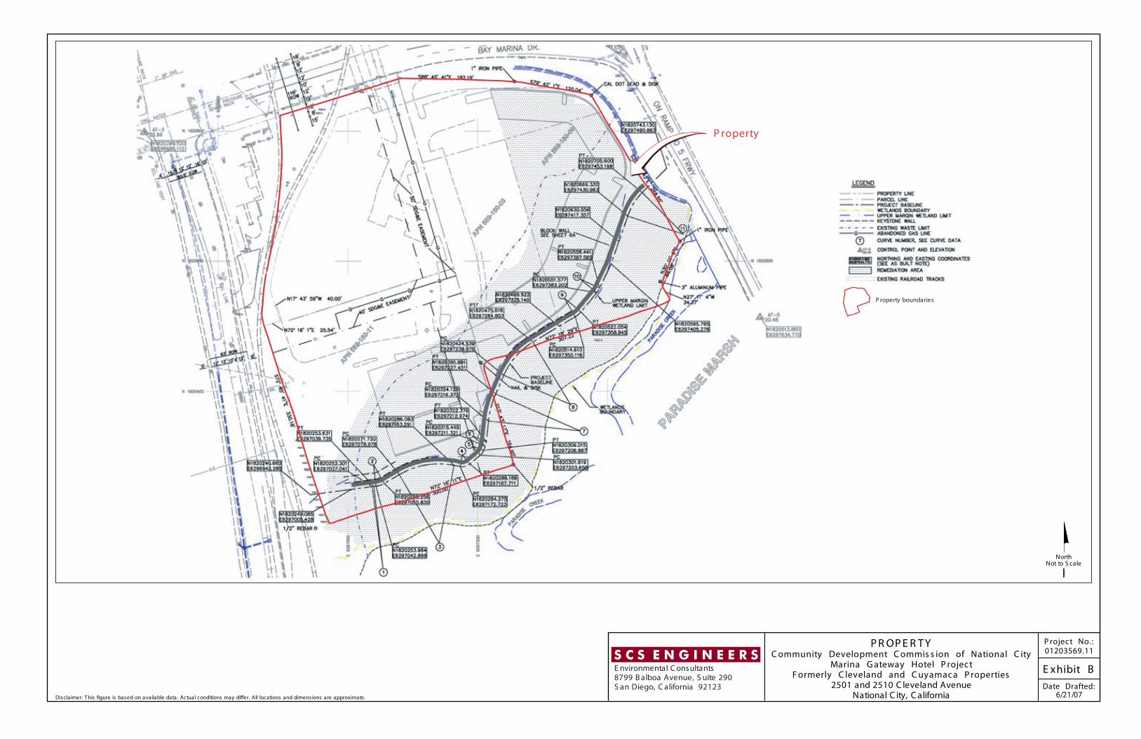
Disclaimer: T his figure is based on available data. Actual conditions may differ. All locations and dimensions are approximate.
P R OP E R T YC ommunity Development C ommis s ion of National C ity
Marina G ateway Hotel P rojec tF ormerly C leveland and C uyamac a P roperties
2501 and 2510 C leveland AvenueNational C ity, C alifornia
E xhibit B
P rojec t No.:01203569.11
Date Drafted:6/21/07
S C S E N G I N E E R SE nvironmental C onsultants8799 B alboa Avenue, S uite 290S an Diego, C alifornia 92123
NorthNot to S cale
P roperty
P roperty boundaries

Disclaimer: T his figure is based on available data. Actual conditions may differ. All locations and dimensions are approximate.
C A P P E D A R E A OF P R OP E R T YC ommunity Development C ommis s ion of National C ity
Marina G ateway Hotel P rojec tF ormerly C leveland and C uyamac a P roperties
2501 and 2510 C leveland AvenueNational C ity, C alifornia
E xhibit C
P rojec t No.:01203569.11
Date Drafted:6/14/07
S C S E N G I N E E R SE nvironmental C onsultants8799 B alboa Avenue, S uite 290S an Diego, C alifornia 92123
NorthNot to S cale
C apped A rea of P roperty
C apped area of P roperty
*
*P revious ly estimated waste limit, not existing waste limit.