leica flexline ts06plus - leica...
TRANSCRIPT

Leica FlexLine TS06plusTop precision meets high efficiency

The First Plus: Original Leica Geosystems quality
For most, “quality” is relative. Not so at Leica Geosystems. To ensure our instruments meet the highest precision and quality requirements, we manufacture them in state-of-the-art facilities around the world. Swiss technology combines with exceptional craftsmanship to provide best-in-class devices. And this quality also applies to all of our procedures – moving Leica Geosystems towards business excellence to meet our customers’ needs and expectations in every way. The Leica FlexLine TS06plus manual total station is ideal for many daily surveying tasks, especially for mid- to high-accuracy applications. Banking on the heritage of the previous TS06 model, the most successful of the Leica FlexLine Series, the FlexLine TS06plus is the newest ultimate total station.
Welcome to the world of Leica Geosystems. Welcome to a world of people, technologies, services and devices, that you can completely rely on.

The Third Plus: Top precision, speed and efficiencyThe claim "easy-to-operate" seems to be everywhere. Whether this promise can be kept only becomes appar-ent in the practice. Because professional measurement experts were involved in its development, the Leica FlexLine TS06plus allows you to work quickly and effectively right from the first day.
Electronic Distance MeasurementWherever high-distance measurement accuracy is required, you can face the challenge of this demanding task with the TS06plus. It provides the most accurate Electronic Distance Measurement.
Prism Mode�� Precision+ (1.5 mm + 2 ppm)�� Speed (1 second)
Non-Prism Mode�� Precision (2 mm + 2 ppm)�� PinPoint EDM with coaxial, small laser pointer and
measurement beam for accurate aiming and measuring
�� Fewer set-ups required, because targets on which it is not possible to set up a reflector can be measu-red using reflectorless measurement up to 1,000
Leica Geosystems – mySecurity mySecurity gives you total peace of mind. If your instrument is ever stolen, a locking mechanism is available to ensure that the device is disabled and can no longer be used.
Built-in user friendliness: The full alpha-numericalkeyboard.The Leica TS06plusstandard built-in
alpha-numerical keyboard enables fast and easy entryof numbers, letters and special characters, e.g. forcoding. It increases the work speed while at the sametime reducing possible sources of error.
FlexField plus on-board software: Easy-to-use due to its graphical guidance and intuitive workflows.
The Leica FlexLine TS06plus communication side cover enables cable-free connection to any data collector via Bluetooth®, for example the field-controllers Leica CS20 controller or Leica CS35 tablet with Captivate software. The USB-stick enables the flexible transfer of such data as GSI, DXF, ASCII, LandXML and CSV.
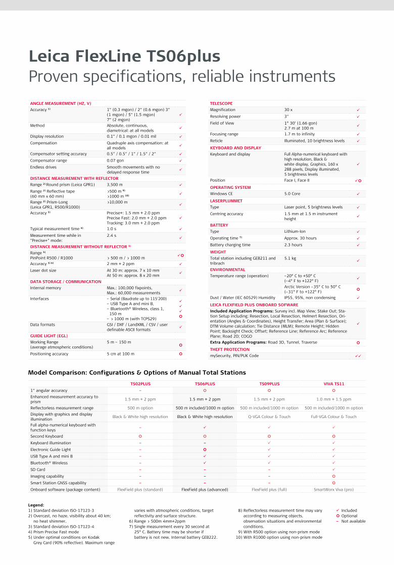
Leica FlexLine TS06plusProven specifications, reliable instruments
Legend:1) Standard deviation ISO-17123-32) Overcast, no haze, visibility about 40 km;
no heat shimmer.3) Standard deviation ISO-17123-44) Prism Precise Fast mode5) Under optimal conditions on Kodak
Grey Card (90% reflective). Maximum range
varies with atmospheric conditions, target reflectivity and surface structure.6) Range > 500m 4mm+2ppm7) Single measurement every 30 second at
25° C. Battery time may be shorter if battery is not new. Internal battery GEB222.
8) Reflectorless measurement time may vary according to measuring objects, observation situations and environmental conditions.
9) With R500 option using non-prism mode10) With R1000 option using non-prism mode
IncludedOptional–Not available
Model Comparison: Configurations & Options of Manual Total Stations
TS02PLUS TS06PLUS TS09PLUS VIVA TS11
1” angular accuracy –
Enhanced measurement accuracy to prism 1.5 mm + 2 ppm 1.5 mm + 2 ppm 1.5 mm + 2 ppm 1.0 mm + 1.5 ppm
Reflectorless measurement range 500 m option 500 m included/1000 m option 500 m included/1000 m option 500 m included/1000 m optionDisplay with graphics and display illumination Black & White high resolution Black & White high resolution Q-VGA Colour & Touch Full-VGA Colour & Touch
Full alpha-numerical keyboard with function keys –
Second Keyboard
Keyboard illumination – –
Electronic Guide Light –
USB Type A and mini B –
Bluetooth® Wireless –
SD Card – – –
Imaging capability – – –
Smart Station GNSS capability – – –
Onboard software (package content) FlexField plus (standard) FlexField plus (advanced) FlexField plus (full) SmartWorx Viva (pro)
ANGLE MEASUREMENT (HZ, V)Accuracy 1) 1” (0.3 mgon) / 2” (0.6 mgon) 3”
(1 mgon) / 5” (1.5 mgon) 7” (2 mgon)
Method Absolute, continuous, diametrical: at all models
Display resolution 0.1” / 0.1 mgon / 0.01 mil
Compensation Quadruple axis compensation: at all models
Compensator setting accuracy 0.5” / 0.5” / 1” / 1.5” / 2”
Compensator range 0.07 gon
Endless drives Smooth movements with no delayed response time
DISTANCE MEASUREMENT WITH REFLECTORRange 2) Round prism (Leica GPR1) 3,500 m
Range 2) Reflective tape (60 mm x 60 mm)
>500 m 9)
>1000 m 10)
Range 2) Prism-Long (Leica GPR1, R500/R1000)
>10,000 m
Accuracy 3) Precise+: 1.5 mm + 2.0 ppmPrecise Fast: 2.0 mm + 2.0 ppmTracking: 3.0 mm + 2.0 ppm
Typical measurement time 4) 1.0 s
Measurement time while in "Precise+" mode:
2.4 s
DISTANCE MEASUREMENT WITHOUT REFLECTOR 8)
Range 5)
PinPoint R500 / R1000 > 500 m / > 1000 m
Accuracy 3) 6) 2 mm + 2 ppm
Laser dot size At 30 m: approx. 7 x 10 mmAt 50 m: approx. 8 x 20 mm
DATA STORAGE / COMMUNICATIONInternal memory Max.: 100,000 fixpoints,
Max.: 60,000 measurements
Interfaces – Serial (Baudrate up to 115’200) – USB Type A and mini B, – Bluetooth® Wireless, class 1, 150 m – > 1000 m (with TCPS29)
Data formats GSI / DXF / LandXML / CSV / user definable ASCII formats
GUIDE LIGHT (EGL)Working Range (average atmospheric conditions)
5 m – 150 m
Positioning accuracy 5 cm at 100 m
TELESCOPEMagnification 30 x
Resolving power 3”
Field of View 1° 30’ (1.66 gon)2.7 m at 100 m
Focusing range 1.7 m to infinity
Reticle Illuminated, 10 brightness levels
KEYBOARD AND DISPLAYKeyboard and display Full Alpha-numerical keyboard with
high resolution, Black &white display, Graphics, 160 x288 pixels, Display illuminated, 5 brightness levels
Position Face I, Face II
OPERATING SYSTEMWindows CE 5.0 Core
LASERPLUMMETType Laser point, 5 brightness levels
Centring accuracy 1.5 mm at 1.5 m instrument height
BATTERY Type Lithium-Ion
Operating time 7) Approx. 30 hours
Battery charging time 2.3 hours
WEIGHT Total station including GEB211 and tribrach
5.1 kg
ENVIRONMENTALTemperature range (operation) –20° C to +50° C
(–4° F to +122° F)
Arctic Version –35° C to 50° C (–31° F to +122° F)
Dust / Water (IEC 60529) Humidity IP55, 95%, non condensing
LEICA FLEXFIELD PLUS ONBOARD SOFWAREIncluded Application Programs: Survey incl. Map View; Stake Out; Sta-tion Setup including: Resection, Local Resection, Helmert Re section, Ori-entation (Angles & Coordinates), Height Transfer; Area (Plan & Surface); DTM Volume calculation; Tie Distance (MLM); Remote Height; Hidden Point; Backsight Check; Offset; Reference Line; Reference Arc; Reference Plane; Road 2D; COGO
Extra Application Programs: Road 3D, Tunnel, Traverse
THEFT PROTECTIONmySecurity, PIN/PUK Code

The Second Plus: Real features, true benefits
USB Stick �� For fast and easy
transfer of data
Wireless Bluetooth®
For cable-free connection to data logger
Electronic Guide Light�� For faster
stake-out
FlexField plus�� Modern and
intuitive onboard software for higher producti-vity
PinPoint EDM�� The most precise in its class
(1.5 mm + 2 ppm)�� Extremely fast (1 second)�� > 1,000 metres without
prism�� Coaxial laser pointer and
measurement beam
Alpha-numerical keyboard�� Fast and error-
free input
Large high-resolution display�� At-a-glance viewing
on the largest high-resolution display in its class
Useful tools�� A range of
tools, such as a trigger key and laser plummet, speed up your work
mySecurity�� Unique theft
protection locking mechanism
Arctic version�� For use at –35°C (–31°F)
Original Accessories
Leica Geosystems Original ZubehörMaterial matters
Original AccessoriesBrochure
Viva TS11Brochure
FlexFieldplusBrochure
FlexLine TS09plusBrochure
FlexLine TS02plusBrochure
The Bluetooth® word mark and logos are owned by Bluetooth SIG, Inc. and any use of such marks by Leica Geosystems AG is under license.
Other trademark and trade names are those of their respective owners.
Cover picture: Dubai City Skyline
Illustrations, descriptions and technical data are not binding. All rights reserved. Printed in Switzerland.Copyright Leica Geosystems AG, Heerbrugg, Switzerland, 2016. 789488en – 06.16
Revolutionising the world of measurement and survey for nearly 200 years, Leica Geosystems creates complete solutions for professionals across the planet. Known for premium products and innovative solution development, professionals in a diverse mix of industries, such as aerospace and defence, safety and security, construction, and manufacturing, trust Leica Geosystems for all their geospatial needs. With precise and accurate instruments, sophisticated software, and dependable services, Leica Geosystems delivers value every day to those shaping the future of our world.
Leica Geosystems is part of Hexagon (Nasdaq Stockholm: HEXA B; hexagon.com), a leading global provider of information technologies that drive quality and productivity improvements across geospatial and industrial enterprise applications.
Leica Geosystems AGleica-geosystems.com
Leica FlexLine TS06plusTop precision meets high efficiency
The Second Plus: Real Features, True Benefits
USB Stick �� For fast and easy
transfer of data
Wireless Bluetooth �� For cable-free
connection to data logger
Electronic Guide Light�� For faster
stake-out
FlexField plus�� Modern and
intuitive on-board software for higher productivity
PinPoint EDM�� The most precise in its class
(1.5 mm + 2 ppm)�� Extremely fast (1 second)�� > 1.000 meters without prism�� Coaxial laser pointer and
measurement beam
Alpha-numerical keyboard�� Fast and error-
free input
Large high-resolution display�� At-a-glance viewing
on the largest high-resolution display in its class
Useful tools�� A range of
tools, such as a trigger key and laser plummet, speed up your work
mySecurity�� Unique cloud-
based protection against theft
Arctic version�� For use at –35°C (–31°F)
Original Accessories
Leica Geosystems Original ZubehörMaterial matters
Leica FlexField plusAn application for every task
Leica FlexLine TS09plusFull Precision at High Performance
Leica FlexLine TS02plusBest-In-Class Precision
Original AccessoriesBrochure
Viva TS11Brochure
FlexField plus & FlexOfficeBrochure
FlexLine TS09plusBrochure
FlexLine TS02plusBrochure
Distance meter: (PinPoint R500 / R1000):Laser class 3R in accordance with IEC 60825-1 resp. EN 60825-1
Laser plummet:Laser class 2 in accordance with IEC 60825-1 resp. EN 60825-1
Distance meter: (Prism Mode)Laser class 1 in accordance with IEC 60825-1 resp. EN 60825-1
Guide light (EGL):LED class 1 in accordance with IEC 60825-1 resp. EN 60825-1
The Bluetooth® word mark and logos are owned by Bluetooth SIG, Inc. and any use of such marks by Leica Geosystems AG is under license.
Other trademark and trade names are those of their respective owners.
Cover picture: Dubai City Skyline
Illustrations, descriptions and technical data are not binding. All rights reserved. Printed in Switzerland.Copyright Leica Geosystems AG, Heerbrugg, Switzerland, 2016. 789488en – 04.16
Leica Geosystems – when it has to be right
Revolutionising the world of measurement and survey for nearly 200 years, Leica Geosystems creates complete solutions for professionals across the planet. Known for premium products and innovative solution development, professionals in a diverse mix of industries, such as aerospace and defence, safety and security, construction, and manufacturing, trust Leica Geosystems for all their geospatial needs. With precise and accurate instruments, sophisticated software, and dependable services, Leica Geosystems delivers value every day to those shaping the future of our world.
Leica Geosystems is part of Hexagon (Nasdaq Stockholm: HEXA B; hexagon.com), a leading global provider of information technologies that drive quality and productivity improvements across geospatial and industrial enterprise applications.
Leica Geosystems AGwww.leica-geosystems.com
Leica FlexLine TS02plusData sheet
Leica FlexLine TS09plusFull precision at high performance
The Second Plus: Real Features, True Benefits
OriginalAccessoriesBrochure
Viva TS11Brochure
FlexField plus &FlexOfficeBrochure
FlexLineTS06plusBrochure
FlexLineTS02plusBrochure
Distance meter: (PinPoint R500 / R1000):Laser class 3R in accordance with IEC 60825-1 resp. EN 60825-1
Laser plummet:Laser class 2 in accordance with IEC 60825-1 resp. EN 60825-1
Distance meter: (Prism Mode)Laser class 1 in accordance with IEC 60825-1 resp. EN 60825-1
Guide light (EGL):LED class 1 in accordance with IEC 60825-1 resp. EN 60825-1
The Bluetooth® word mark and logos are owned by Bluetooth SIG, Inc. and any use of such marks by Leica Geosystems AG is under license.
Other trademark and trade names are those of their respective owners.
Cover picture: Shanghai Pudong Skyline
Illustrations, descriptions and technical data are not binding. All rights reserved. Printed in Switzerland. Copyright Leica Geosystems AG, Heerbrugg, Switzerland, 2016. 789508en-us – 04.16
Original Accessories
Leica Geosystems Original ZubehörMaterial matters
Leica FlexLine TS06plusTop Precision meets High Efficiency
Leica FlexLine TS02plusBest-In-Class Precision
Leica FlexField plusAn application for every task
USB Stick �� For fast and easy
transfer of data
Wireless Bluetooth® �� For cable-free
connection to data logger
Electronic Guide Light�� For faster
stake-out
FlexField plus�� Modern and
intuitive on-board software for higher productivity
PinPoint EDM�� The most precise in its class
(1.5 mm + 2 ppm)�� Extremely fast (1 second)�� > 1.000 meters without prism�� Coaxial laser pointer and
measurement beam
Color & Touch Display �� Highest user-
friendliness
Useful tools�� A range of tools,
such as a trigger key and laser plummet, speed up your work
Arctic version�� For use at
–35°C (–31°F)
mySecurity�� Unique cloud-
based protection against theft
Leica Geosystems – when it has to be right
Revolutionising the world of measurement and survey for nearly 200 years, Leica Geosystems creates complete solutions for professionals across the planet. Known for premium products and innovative solution development, professionals in a diverse mix of industries, such as aerospace and defence, safety and security, construction, and manufacturing, trust Leica Geosystems for all their geospatial needs. With precise and accurate instruments, sophisticated software, and dependable services, Leica Geosystems delivers value every day to those shaping the future of our world.
Leica Geosystems is part of Hexagon (Nasdaq Stockholm: HEXA B; hexagon.com), a leading global provider of information technologies that drive quality and productivity improvements across geospatial and industrial enterprise applications.
Leica Geosystems AGwww.leica-geosystems.com