leica gm10 technical data
TRANSCRIPT

Leica GM10Technical data
Version 1.0English

Leica GM10 - Technical Data, Introduction 2
IntroductionThis brochure contains important technical data regarding GNSS Receivers and Antennas.Read carefully through the Technical Data.
Trademarks • Windows is a registered trademark of Microsoft Corporation in the United States and other countries
• SD is a trademark of the SD Card AssociationAll other trademarks are the property of their respective owners.
Validity of this brochure
This brochure applies to the Leica GM10.
myWorld@Leica Geosystems (https://myworld.leica-geosystems.com) offers a wide range of services, information and training material.With direct access to myWorld, you are able to access all relevant services whenever it is convenient for you, 24 hours a day, 7 days per week. This increases your efficiency and keeps you and your equipment instantly updated with the latest information from Leica Geosystems.
Service DescriptionmyProducts Add all Leica Geosystems products that you and your company
own. View detailed information on your products, buy additional options or Customer Care Packages (CCPs), update your products with the latest software and keep up-to-date with the latest documentation.
myService View the service history of your products in Leica Geosystems Service Centres and detailed information on the services performed on your products. For your products that are currently in Leica Geosystems Service Centres view the current service status and the expected end date of service.
mySupport Create new support requests for your products that will be answered by your local Leica Geosystems Support Team. View the complete history of your Support and view detailed informa-tion on each request in case you want to refer to previous support requests.
myTraining Enhance your product knowledge with the Leica Geosystems Campus - Information, Knowledge, Training. Study the latest online training material or download training material on your products. Keep up-to-date with the latest News on your prod-ucts and register for Seminars or Courses in your country.
myTrustedServices Offers increased productivity while at the same time providing maximum security.• myExchange
With myExchange you can exchange any files/objects from your computer to any of your Leica Exchange Contacts.
• mySecurityIf your instrument is ever stolen, a locking mechanism is avail-able to ensure that the instrument is disabled and can no longer be used.

Leica GM10 - Technical Data, Table of Contents 3
Table of ContentsIn this brochure Chapter Page
1 LeicaGM10GNSSMonitoring Receiver 4
1.1 Overview 41.2 Tracking Characteristics 6
1.2.1 Overview 61.2.2 Measurement Precision 71.2.3 Measurement Resolution 71.2.4 Accuracy 7
1.3 Data Recording 91.4 Data Streaming 101.5 Memory 111.6 User Interface 12
1.6.1 Overview 121.6.2 GM10 User Interface 121.6.3 Operation 13
1.7 Connectors, Ports and Devices 141.7.1 Connector Ports Overview 141.7.2 Connectors 151.7.3 Communications Devices 161.7.4 External Controllers 16
1.8 Ethernet Services 171.9 Weight & Dimensions 171.10 Environmental Specifications 181.11 Power & Electrical Certifications 19
2 GNSS Antennas 20
Leica GM10 - Technical Data, Leica GM10 GNSS Monitoring Receiver 4
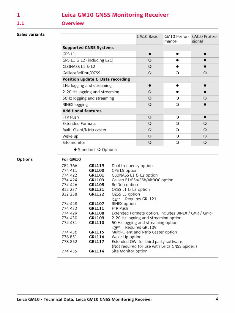
1 Leica GM10 GNSS Monitoring Receiver1.1 Overview
Sales variants
Standard Optional
Options For GM10
GM10 Basic GM10 Perfor-mance
GM10 Profes-sional
Supported GNSS SystemsGPS L1
GPS L1 & L2 (including L2C)
GLONASS L1 & L2
Galileo/BeiDou/QZSS
Position update & Data recording1Hz logging and streaming
2-20 Hz logging and streaming
50Hz logging and streaming
RINEX logging
Additional featuresFTP Push
Extended Formats
Multi-Client/Ntrip caster
Wake up
Site monitor
782 366 GRL119 Dual frequency option774 411 GRL100 GPS L5 option774 422 GRL101 GLONASS L1 & L2 option774 424 GRL103 Galileo E1/E5a/E5b/AltBOC option774 426 GRL105 BeiDou option812 237 GRL121 QZSS L1 & L2 option812 238 GRL122 QZSS L5 option
Requires GRL121774 428 GRL107 RINEX option774 432 GRL111 FTP Push774 429 GRL108 Extended Formats option. Includes BINEX / CMR / CMR+774 430 GRL109 2-20 Hz logging and streaming option774 431 GRL110 50 Hz logging and streaming option
Requires GRL109774 436 GRL115 Multi-Client and Ntrip Caster option778 851 GRL116 Wake-Up option778 852 GRL117 Extended OWI for third party software.
(Not required for use with Leica GNSS Spider.)774 435 GRL114 Site Monitor option

Leica GM10 - Technical Data, Leica GM10 GNSS Monitoring Receiver 5
Hardware and Software
Standard Optional * Requires a valid Customer Care Package (CCP) contract for firmware mainte-nance and support.** Weight with bumpers
GM10Connectors/PortsPower Input Pins (Lemo) 2Ethernet RJ45 ruggedized
Serial (Lemo) 1External Oscillator
USB Client
Slot-in communication port
User InterfacePower Button
Function Button 1LEDs 6Web Interface
GNSS Spider Support
Data Storage/LoggingMemory Type SD/SDHCMemory Size 32 GBMaximum Data Rate (Hz) 50 HzProprietary (MDB)
RINEX v2.11, v3.01, v3.02RINEX Hatanaka
Zip File Compression
Data StreamingMaximum Data Rate (Hz) 50 HzTCP/IP Netports 20ServicesHTTP / HTTPS
FTP Server
DHCP / DNS
DynDNS
SNMP
Active Assist *SSL
Internet connection sharing
Electrical SpecificationsPower Consumption (watts) 3.5 wPhysical SpecificationsSize (mm) 210x190x78Weight (kg) 1.67 kg**

Leica GM10 - Technical Data, Leica GM10 GNSS Monitoring Receiver 6
1.2 Tracking Characteristics1.2.1 Overview
Instrument tech-nology
Leica patented SmartTrack+ technology• Advanced measurement engine• Jamming resistant measurements• High precision pulse aperture multipath correlator for pseudorange measure-
ments• Excellent low elevation tracking• Very low noise GNSS carrier phase measurements with <0.5 mm precision• Minimum acquisition time
Number of Satellites
The number of satellites that can be tracked:Up to 60 satellites simultaneous dual-frequency, up to 7 signals per satellite, 120 channels
Satellites’ signals tracking
The following satellites’ signals are tracked• GPS: L1, L2P, L2C, L5• GLONASS: L1, L2P, L2C• Galileo: E1, E5a, E5b, AltBOC• BeiDou: B1, B2• QZSS: L1, L2, L5• SBAS: WAAS, EGNOS, GAGAN, MSAS
GNSS measure-ments
Fully independent code and phase measurements of all frequencies.
GPS Carrier tracking
GPS code measure-ments
Carrier phase and code measurements on L1, L2 and L5 (GPS) are fully inde-pendent of AS on or off.
Type L1, AS off or on L2, AS off L2, AS onGM10 Reconstructed carrier
phase via C/A-code.Reconstructed carrier phase via P2-code
Switches automatically to patented P-code aided technique providing full L2 recon-structed carrier phase.
Type L1, AS off L1. AS of L2, AS off L2, AS onGM10 Carrier phase
smoothed code meas-urements: C/A code.
Carrier phase smoothed code meas-urements: P2-code and/or L2C code.
Carrier phase smoothed code meas-urements: Patented P-code aided code and/or L2C code.

Leica GM10 - Technical Data, Leica GM10 GNSS Monitoring Receiver 7
1.2.2 Measurement Precision
Measurement preci-sion
* GPS L5 and Galileo E1/E5a/E5b/AltBOC values are expected to be similar to L1. Final values will be determined after initial operational capability (IOC) has been reached.
1.2.3 Measurement Resolution
Measurement reso-lution
1.2.4 Accuracy
Accuracy is dependent upon various factors including the number of satellites tracked, constellation geometry, observation time, ephemeris accuracy, ionospheric distur-bance, multipath and resolved ambiguities.
The following accuracies, given as root mean square, are based on measurements processed using Leica Geo Office and the Bernese Software.
The use of multiple GNSS systems can increase accuracy by up to 30% relative to GPS only.
Accuracy (rms) single receiver navi-gation mode
Navigation accuracy 5–10 m rms for each coordinate Degradation possible due to Selective Availability
Accuracy in differ-ential code mode
The baseline precision of a differential code solution for static and kinematic surveys is 25 cm.
Type Carrier phase Code (pseudorange)GM10 L1: 0.2 mm rms L1: 20 mm rms
L2: 0.2 mm rms L2: 20 mm rms
Type Resolution phase Resolution codeGM10 0.01 mm 0.0005 m

Leica GM10 - Technical Data, Leica GM10 GNSS Monitoring Receiver 8
Accuracy in differ-ential phase mode
1) Measurement precision, accuracy and reliability are dependent upon various factors including number of satellites, geometry, obstructions, observation time, ephemeris accuracy, ionospheric conditions, multipath etc. Figures quoted assume normal to favorable conditions. Times required are dependent upon various factors including number of satellites, geometry, ionospheric conditions, multipath etc. GPS and GLONASS can increase performance and accuracy by up to 30% relative to GPS only. A full Galileo and GPS L5 constellation will further increase measurement performance and accuracy.2) Might vary due to atmospheric conditions, signal multipath, obstructions, signal geometry and number of tracked signals.
Note: The above accuracy values for post processing are based on using the Leica Geo Office. Using specialist scientific software (Bernese) available from Leica Geosystems, the following accuracies can be achieved in static post processing mode, even on very long baselines:
Accuracy (rms) with Post Processing1)
Horizontal VerticalStatic (phase) with long observations
3 mm + 0.1 ppm 3.5 mm + 0.4 ppm
Static and rapid static (phase)
3 mm + 0.5 ppm 5 mm + 0.5 ppm
Kinematic (phase) 8 mm + 1 ppm 15 mm + 1 ppm
Accuracy (rms) with Real Time (RTK)1)
Standard of compliance Compliance with ISO17123-8Site Monitor Positioning Modes
Reference Station Monitoring Network RTK Rover
(Horizontal/Vertical) H V H V H VSingle Baseline (<30 km) 6 mm +
1 ppm10 mm + 1 ppm
8 mm + 1 ppm
15mm + 1 ppm
8 mm + 1 ppm
15 mm + 1 ppm
Network RTK 6 mm + 0.5 ppm
10 mm + 0.5 ppm
8 mm + 0.5 ppm
15 mm + 0.5 ppm
8 mm + 0.5 ppm
15 mm + 0.5 ppm
Sampling Smoothed Instantaneous InstantaneousOn-the-fly (OTF) initialisationRTK technology Leica SmartCheck technologyReliability of OTF initialisation1)
≥ 99,999% ≥ 99,999% ≥ 99,99%
Time for initialisation (typically)2)
10 seconds 10 seconds 4 seconds
OTF range2) Up to 80 km Up to 70 km Up to 70 km
Network RTKNetwork technology Leica SmartRTK technologySupported RTK network solutions
VRS, FKP, iMAX
Supported RTK network standards
MAC (Master Auxiliary Concept) approved by RTCM SC104
• 2 - 4 mm in plan • 3 - 6 mm in height

Leica GM10 - Technical Data, Leica GM10 GNSS Monitoring Receiver 9
1.3 Data Recording
Data recording
Standard Optional - Needs Upgrade
RINEX logging when configured will generate files in real time. On the GM10 RINEX files can be logged independently without the need to log raw Leica MDB files.
GM10Data StorageStorage Type (removable) SD/SDHC (yes)Logging channels 12Multi session logging
Auto-delete
Smart Clean-up
User Defined folders
Data TypesLeica raw (MDB)
RINEX v2.11, v3.01, v3.02
Hatanaka
Zipping of raw files
Zipping of RINEX files
File SizesMaximum 24 hMinimum 5 minData RatesMaximum (MDB) 50 HzMaximum (RINEX) 20 HzMinimum (MDB+RINEX) 300 sLogging TypesContinuous
Timed

Leica GM10 - Technical Data, Leica GM10 GNSS Monitoring Receiver 10
1.4 Data Streaming
Data streaming
Standard Optional
1 Requires Multi Client option2 Whilst the Ntrip Caster supports unlimited client connections, performance and
data latency will depend on the quality and bandwidth of the communications used. Users should limit the number of clients depending on the communications being used.
GM10Data StreamingMaximum number of streams 20Maximum number of real time streams 10Streaming PortSerial ports 1TCP/IP ports 20USB client port 1Slot communication port 1Data Types and ratesLeica 10 HzLeica 4G 10 HzRTCM 2.1, 2.2 and 2.3 10 HzRTCM 3.0, 3.1, 3.2 10 HzCMR/CMR+ 10 HzBINEX records 0x00, 0x01, 0x7d, 0x7e, 0x7f 10 HzLeica Proprietary LB2 50 HzNMEA 0183 v2.20 and Leica Proprietary 10 HzMulti ClientsClients per TCP/IP net port 101
Ntrip Caster unlimited2
Time slicing of RTK output
Leica GM10 - Technical Data, Leica GM10 GNSS Monitoring Receiver 11
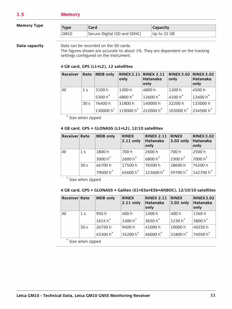
1.5 Memory
Memory Type
Data capacity Data can be recorded on the SD cards.The figures shown are accurate to about 1%. They are dependent on the tracking settings configured on the instrument.
4 GB card, GPS (L1+L2), 12 satellites
* Size when zipped
4 GB card, GPS + GLONASS (L1+L2), 12/10 satellites
* Size when zipped
4 GB card, GPS + GLONASS + Galileo (E1+E5a+E5b+AltBOC), 12/10/10 satellites
* Size when zipped
Type Card CapacityGM10 Secure Digital (SD and SDHC) Up to 32 GB
Receiver Rate MDB only RINEX 2.11 only
RINEX 2.11 Hatanaka only
RINEX 3.02 only
RINEX 3.02 Hatanaka only
All 1 s 3100 h 1300 h 4800 h 1300 h 4500 h
5300 h* 4800 h* 12600 h* 4100 h* 12600 h*
30 s 76400 h 31800 h 140000 h 32200 h 133000 h
130000 h* 119000 h* 222000 h* 103000 h* 234500 h*
Receiver Rate MDB only RINEX 2.11 only
RINEX 2.11 Hatanaka only
RINEX 3.02 only
RINEX 3.02 Hatanaka only
All 1 s 1800 h 700 h 2600 h 700 h 2500 h
3000 h* 2600 h* 6800 h* 2300 h* 7000 h*
30 s 46700 h 17500 h 76500 h 18600 h 74200 h
79000 h* 65600 h* 123600 h* 59700 h* 142700 h*
Receiver Rate MDB only RINEX 2.11 only
RINEX 2.11 Hatanaka only
RINEX 3.02 only
RINEX 3.02 Hatanaka only
All 1 s 950 h 400 h 1400 h 400 h 1360 h
1614 h* 1400 h* 3650 h* 1230 h* 3800 h*
30 s 26750 h 9400 h 41000 h 10000 h 40250 h
45300 h* 35200 h* 66000 h* 31800 h* 74050 h*

Leica GM10 - Technical Data, Leica GM10 GNSS Monitoring Receiver 12
1.6 User Interface1.6.1 Overview
Buttons/LEDs
Web Interface The GM10 Series have integrated web interface functionality that provides full status information and configuration options. The web interface contains a detailed Event/Message log that keeps the user informed of all important activities. The web interface also contains a detailed built in online help.
GNSS Spider The GM10 Series can be configured and maintained using the Leica GNSS Spider Soft-ware.
1.6.2 GM10 User Interface
GM10 button func-tionality
• Receiver power up/power down• Start/stop all logging sessions• Start/stop all data streams• Initialize the measurement engine• Reset receiver settings• Format SD card
GM10 LED status indicator
• Power LED• SD card LED• Raw data logging LED• RT out data stream LED• RT in data stream LED• Position LED
GM10ON / OFF button 1Functions button 1LEDs 6

Leica GM10 - Technical Data, Leica GM10 GNSS Monitoring Receiver 13
1.6.3 Operation
Internet connec-tivity
Web interface for remote configuration, operation and status displays. Supports HTTP and HTTPS. The GM10 additionally supports DHCP/DNS and unique hostname.
Web interface ports:• USB Client Port• Simultaneous access over Ethernet port is fully supported
Security Access restrictions configurable in User Management component:• Viewers (status only)• Users/GNSS Managers (configuration and status)• Administrators• SSL encryption
E-MailSending of message log in scheduled intervals over email. Ethernet and PPP connection to the internet is supported.
FTP Push (optional)Automated FTP Push of raw data and/or RINEX files to a remote FTP server. Ethernet and PPP connection to the internet is supported.
RTK Multiplexing / Multi ClientOption to allow RTK data streaming direct from the sensor, via TCPIP, for up to 10 clients per TCP/IP port. Unlimited clients supported on the GM10 using Ntrip Caster.
DynDNSAllows receiver addressing with dynamic IP address through a static host name, Requires registration with a DynDNS service.
OWI interface Leica proprietary Outside World Interface - OWI - for receiver control commands from PC etc, for receiver configuration, control and status, e.g. using Leica GNSS Spider. Binary and ASCII version of the OWI protocol are available. Supported via serial and TCP/IP ports. Simultaneous access, control and message output is fully supported. The OWI use requires a license option to be used with third party software. Using the GM10 with Leica GNSS Spider does not require the OWI license option.

Leica GM10 - Technical Data, Leica GM10 GNSS Monitoring Receiver 14
1.7 Connectors, Ports and Devices1.7.1 Connector Ports Overview
Connector ports GM10
Data Links
* Using any available hardware interface (Ethernet, USB, mobile device internet).
Type DescriptionPower 1x Lemo-1 female, 5 pinSerial P1 1x Lemo-1 female, 8 pinGNSS Antenna 1x TNC femaleCommunication Slot port 1x UART Serial/USB for removable internal communica-
tion devicesP3 Slot-in Antenna 1x TNC femaleExternal Oscillator 1x MMCX female, 24QMA-50-2-3/133,5/10 MhzEthernet 1x RJ45 ruggedised, 10/100 MbitUSB USB client (Mini B)
GM10Serial ports (including one Slot-In device port) 2TCP/IP ports* 20Simultaneous data streams 20Concurrent RTK formats 10
Leica GM10 - Technical Data, Leica GM10 GNSS Monitoring Receiver 15
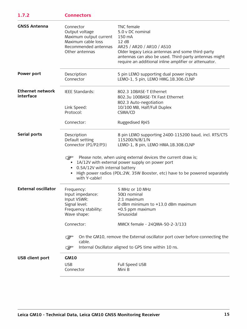
1.7.2 Connectors
GNSS Antenna
Power port
Ethernet network interface
Serial ports
Please note, when using external devices the current draw is;• 1A/12V with external power supply on power port• 0.5A/12V with internal battery• High power radios (PDL:2W, 35W Booster, etc) have to be powered separately
with Y-cable!
External oscillator
On the GM10, remove the External oscillator port cover before connecting the cable.
Internal Oscillator aligned to GPS time within 10 ns.
USB client port GM10
Connector TNC femaleOutput voltage 5.0 v DC nominalMaximum output current 150 mAMaximum cable loss 12 dBRecommended antennas AR25 / AR20 / AR10 / AS10Other antennas Older legacy Leica antennas and some third-party
antennas can also be used. Third-party antennas might require an additional inline amplifier or attenuator.
Description 5 pin LEMO supporting dual power inputsConnector LEMO-1, 5 pin, LEMO HMG.1B.306.CLNP
IEEE Standards: 802.3 10BASE-T Ethernet802.3u 100BASE-TX Fast Ethernet802.3 Auto-negotiation
Link Speed: 10/100 MB, Half/Full DuplexProtocol: CSMA/CD
Connector: Ruggedised RJ45
Description 8 pin LEMO supporting 2400-115200 baud, incl. RTS/CTSDefault setting 115200/N/8/1/NConnector (P1/P2/P3) LEMO-1, 8 pin, LEMO HMA.1B.308.CLNP
Frequency: 5 MHz or 10 MHzInput impedance: 50 nominalInput VSWR: 2:1 maximumSignal level: 0 dBm minimum to +13.0 dBm maximumFrequency stability: +0.5 ppm maximumWave shape: Sinusoidal
Connector: MMCX female - 24QMA-50-2-3/133
USB Full Speed USBConnector Mini B

Leica GM10 - Technical Data, Leica GM10 GNSS Monitoring Receiver 16
1.7.3 Communications Devices
Supported Commu-nications devices
The GM10 Series support a variety of communications devices. All receivers support the use of external serial devices. Leica Geosystems offers many devices in external ruggedised GFU housing. Additionally, the GM10 supports the use of removable slot in communication devices.
Supported Radio modems
• Support of any suitable UFH / VHF radio with RS232 interface and operating in transparent mode
• Satelline3AS in Leica GFU housing, fully sealed and protected, IP67• Pacific Crest PDL in Leica GFU housing, fully sealed and protected, IP67• Satelline M3-TR1 403-470 MHz transmit/receive UHF radio module to be easily
plugged into the GR/GM receiver
Supported GSM / UMTS (HSDPA) phone modems
• Support of any suitable GSM / GPRS / UMTS(HSDPA) modem• Siemens MC75 in Leica GFU housing, Quad-Band 850 / 900 / 1800 / 1900 MHz
fully sealed and protected, IP67
Supported CDMA phone modems
• Support of any suitable CDMA modem• Multitech MTMMC CDMA in Leica GFU housing, Dual-Band 800 / 900 MHz, 1xRTT,
fully sealed and protected, IP67
Supported Landline phone modems
• Support of any suitable Landline phone modem, based on US Robotics or Courier V.90.
Supported Slot in devices for GM10
• Support of a variety of removable slot in devices on the GM10• Satelline TA11 radio, 403-470 MHz TXO• Telit 3G GSM/GPRS/UMTS module, 5-Band 850 / 900 / 1800 / 1900 / 2100 MHz• Cinterion MC75i GSM/GPRS/EDGE module, 4-Band 850 / 900 / 1800 / 1900 MHz• Satelline M3-TR1 403-470 MHz transmit/receive UHF radio module to be easily
plugged into the GR/GM receiver
1.7.4 External Controllers
GM10 • The GM Series has a built in web server software called RefWorx. Any Web enabled device can be used to configure the GM10. The CS10/CS15/CS25 controllers can be used to configure the GM10 only using built in web browser and a USB connection to the GM10.

Leica GM10 - Technical Data, Leica GM10 GNSS Monitoring Receiver 17
1.8 Ethernet Services
Services
Standard Optional
1.9 Weight & Dimensions
Dimensions The dimensions are given for the housing without the sockets.
Weight 1.50 kg (without bumpers), 1.67 kg (with bumpers)
GM10TCP/IP
Static IP
DHCP
DNS
Hostname support
DynDNS
HTTP
HTTPS
User defined HTTP port
User defined HTTPS port
Secure SSL
Custom SSL certificates
FTP Server
User defined FTP ports
Passive mode FTP
Active mode FTP
Simultaneous FTP clients 6Anonymous FTP
FTP push
File download via HTTP
SNMP
TCP/IP server
TCP/IP client
NTRIP server (source)
NTRIP client
NTRIP caster
TCP/IP over USB
Web interface event log
Email alerts
Type Length [mm] Width [mm] Thickness [mm]GM10 210 190 78GM10 with bumpers
220 200 94

Leica GM10 - Technical Data, Leica GM10 GNSS Monitoring Receiver 18
1.10 Environmental Specifications
Environmental specifications
Environmental specifications apply to the receiver including all connectors on the back panel.
Temperature
Compliance with ISO9022-10-08, ISO9022-11-special, MIL-STD-810G - 502.5-II, MIL-STD-810G - 501.5-II (operating) and MIL-STD-810G - 502.5-I, MIL-STD-810G - 501.5-I (storage).
Protection against water, dust and sand
Humidity
Vibration
Drops
Type Operating temperature [°C] Storage temperature [°C]GM10 -40 to +65 -40 to +80Leica SD cards -40 to +85 -40 to +85
Type ProtectionGM10 IP67 (IEC 60529) and MIL-STD-810G - 512.5-I
Dust tightProtected against water jetsWaterproof to 1 m temporary immersion
Type ProtectionGM10 Up to 100 %
Compliance with ISO9022-13-06, ISO9022-12-04 and MIL-STD-810G - 507.5-IThe effects of condensation are to be effectively counter-acted by periodically drying out the instrument.
Type ProtectionGM10 Withstands strong vibration during operation, compliance
with ISO9022-36-08 and MIL-STD-810G - 514.6-Cat.24
Type ProtectionGM10 Withstands 1 m drop onto hard surfaces

Leica GM10 - Technical Data, Leica GM10 GNSS Monitoring Receiver 19
1.11 Power & Electrical Certifications
Operating times Designed for continuous operation.
Supply voltage Nominal 24 V DC, voltage range 10.5 V - 28 V DC
Power consumption 3.5 W typically, 24 V@150 mA
Power supply Dual input
Up to two external power sources can be connected simultaneously.
Certifications Compliance to FCC, CELocal approvals (as IC Canada, C-Tick Australia, Japan, China)RoHSREACH http://www.leica-geosystems.com/en/Reach-Compliance_79929.htm
Leica GM10 - Technical Data, GNSS Antennas 20
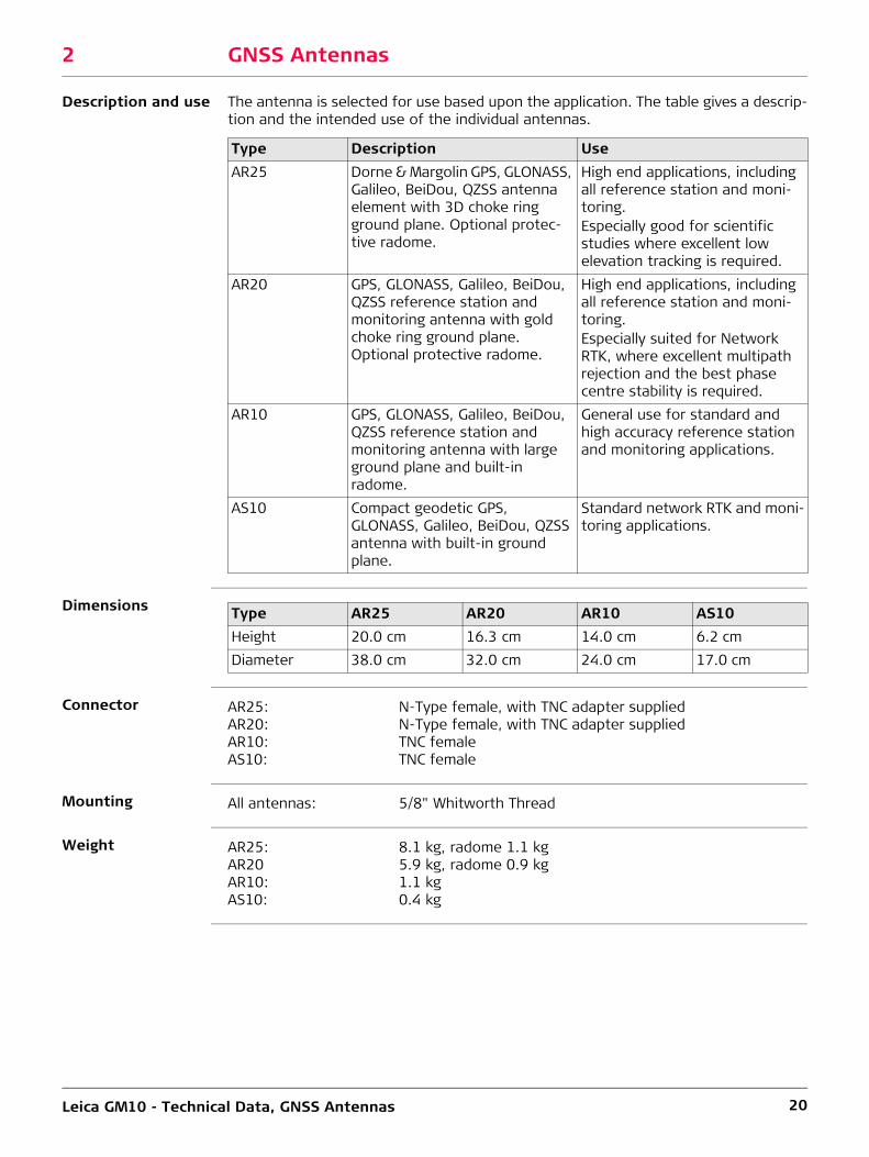
2 GNSS Antennas
Description and use The antenna is selected for use based upon the application. The table gives a descrip-tion and the intended use of the individual antennas.
Dimensions
Connector
Mounting
Weight
Type Description UseAR25 Dorne & Margolin GPS, GLONASS,
Galileo, BeiDou, QZSS antenna element with 3D choke ring ground plane. Optional protec-tive radome.
High end applications, including all reference station and moni-toring.Especially good for scientific studies where excellent low elevation tracking is required.
AR20 GPS, GLONASS, Galileo, BeiDou, QZSS reference station and monitoring antenna with gold choke ring ground plane. Optional protective radome.
High end applications, including all reference station and moni-toring.Especially suited for Network RTK, where excellent multipath rejection and the best phase centre stability is required.
AR10 GPS, GLONASS, Galileo, BeiDou, QZSS reference station and monitoring antenna with large ground plane and built-in radome.
General use for standard and high accuracy reference station and monitoring applications.
AS10 Compact geodetic GPS, GLONASS, Galileo, BeiDou, QZSS antenna with built-in ground plane.
Standard network RTK and moni-toring applications.
Type AR25 AR20 AR10 AS10Height 20.0 cm 16.3 cm 14.0 cm 6.2 cmDiameter 38.0 cm 32.0 cm 24.0 cm 17.0 cm
AR25: N-Type female, with TNC adapter suppliedAR20: N-Type female, with TNC adapter suppliedAR10: TNC femaleAS10: TNC female
All antennas: 5/8" Whitworth Thread
AR25: 8.1 kg, radome 1.1 kgAR20 5.9 kg, radome 0.9 kgAR10: 1.1 kgAS10: 0.4 kg

Leica GM10 - Technical Data, GNSS Antennas 21
Electrical data
Environmental specifications
Temperature
Operating temperatures in compliance with ISO9022-10-08, ISO9022-11-05 and MIL-STD-810G, Method 502.5-II, MIL-STD-810G, Method 501.5-II
Storage temperatures in compliance with ISO9022-10-08, ISO9022-11-06 and MIL-STD-810G, Method 502.5-I, MIL-STD-810G, Method 501.5-I
Protection against water, dust and sand
Type AR25 AR20 AR10 AS10Voltage 3.3 V to
12 V DC3.3 V to 12 V DC
3.3 V to 12 V DC
4.5 V to 18 V DC
Current 100 mA max 100 mA maxl 100 mA maxl 35 mA typicalFrequencyGPS: L1, L2
(including L2C), L5.
L1, L2 (including L2C), L5.
L1, L2 (including L2C), L5.
L1, L2 (including L2C), L5.
GLONASS: L1, L2, L3. L1, L2, L3. L1, L2, L3. L1, L2.Galileo: E2-L1-E1, E5a,
E5b, E5a+b (AltBOC), E6.
E2-L1-E1, E5a, E5b, E5a+b (AltBOC), E6.
E2-L1-E1, E5a, E5b, E5a+b (AltBOC), E6.
E2-L1-E1, E5a, E5b, E5a+b (AltBOC).
BeiDou: B1, B2, B3. B1, B2, B3. B1, B2, B3. B1, B2.QZSS L1, L1C, L2C,
L5, L1-SAIF, LEXL1, L1C, L2C, L5, L1-SAIF, LEX
L1, L1C, L2C, L5, L1-SAIF, LEX
L1, L1C, L2C, L5, L1-SAIF
L-Band SBAS, Omni-STAR,Veripos, CDSGPS
SBAS, Omni-STAR, Veripos, CDSGPS
SBAS, Omni-STAR, Veripos, CDSGPS
-
Gain (typically) 40 dBi 29 dBi 29 dBi 27 dBiNoise Figure (typically)
< 1.2 dBi max < 2 dBi < 2 dBi < 2 dBi
Phase center stability
< 1 mm < 1 mm < 1 mm < 1 mm
Type Operating temperature [°C] Storage temperature [°C]AR25 -55 to +85 -55 to +90AR20 -55 to +85 -55 to +85AR10 -40 to +70 -55 to +85AS10 -40 to +70 -55 to +85
Type ProtectionAll antennas IP67 (IEC 60529)
Dust tightProtected against water jetsWaterproof to 1 m temporary immersion

Leica GM10 - Technical Data, GNSS Antennas 22
Humidity
Vibration
Drops
Cable length Available cable lengths for all antennas (m)
Certifications
Type ProtectionAll antennas Up to 100 %
Compliance with ISO9022-13-06, ISO9022-12-04 and MIL-STD-810G Method 507.5-IThe effects of condensation are to be effectively counteracted by periodically drying out the antenna.
Type RatingAR25 ISO9022-36-05, 10-55 Hz; 0.15 mm, 5 cyclesAR20 ISO9022-36-05, 10-55 Hz; 0.15 mm, 5 cyclesAR10 ISO9022-36-05, 10-55 Hz; 0.15 mm, 5 cyclesAS10 ISO9022-36-08 and MIL-STD-810G Method 514.6-Cat.24
AR25: Withstands 0.6 m drop onto hard surfaces (upside down excluded)AR20: Withstands 1.0 m drop onto hard surfaces (upside down excluded)AR10: Withstands 1.2 m drop onto hard surfacesAS10: Withstands 1.5 m drop onto hard surfaces
Coaxial (5mm): 1.2, 2.8 and 10Coaxial (11mm): 2, 10, 30, 50 and 70
Compliance to FCC, CELocal approvals (as IC Canada, C-Tick Australia, Japan, China)RoHSREACH http://www.leica-geosystems.com/en/Reach-Compliance_79929.htm

Whether you monitor the movement of a volcanic slope, the structure of a long bridge or track the settlement of a dam; whether you measure, analyse and manage the structures of natural or man-made objects: the monitoring systems by Leica Geosystems provide you with the right solution for every application. Our solutions provide reliable, precise data acquisition, advanced processing, sophisticated analysis and secure data transmission. Using standard interfaces, open architectures and scalable platforms, the solutions are customisable to meet indi-vidual requirements - for permanent and temporary installations, for single sites and monitoring networks.
When it has to be right.
Leica Geosystems AGHeinrich-Wild-StrasseCH-9435 HeerbruggSwitzerlandPhone +41 71 727 31 31www.leica-geosystems.com
829761-1.0.0enOriginal text Printed in Switzerland© 2014 Leica Geosystems AG, Heerbrugg, Switzerland