les rues des tableaux: the geography of the parisian art
TRANSCRIPT

Artl@s Bulletin Artl@s Bulletin
Volume 5 Issue 1 South-North-South Article 10
2016
Les rues des tableaux: The Geography of the Parisian Art Market Les rues des tableaux: The Geography of the Parisian Art Market
1815-1955 1815-1955
Léa Saint-Raymond Université Paris Ouest Nanterre La Défense, [email protected]
Félicie de Maupeou Université Paris Ouest Nanterre La Défense, [email protected]
Julien Cavero École normale supérieure, [email protected]
Follow this and additional works at: https://docs.lib.purdue.edu/artlas
Part of the Cultural History Commons, Digital Humanities Commons, Geographic Information
Sciences Commons, and the Social History Commons
Recommended Citation Recommended Citation Saint-Raymond, Léa; Félicie de Maupeou; and Julien Cavero. "Les rues des tableaux: The Geography of the Parisian Art Market 1815-1955." Artl@s Bulletin 5, no. 1 (2016): Article 10.
This document has been made available through Purdue e-Pubs, a service of the Purdue University Libraries. Please contact [email protected] for additional information.
This is an Open Access journal. This means that it uses a funding model that does not charge readers or their institutions for access. Readers may freely read, download, copy, distribute, print, search, or link to the full texts of articles. This journal is covered under the CC-BY-NC-SA license.

Les rues des tableaux: The Geography of the Parisian Art Market 1815-1955 Les rues des tableaux: The Geography of the Parisian Art Market 1815-1955
Cover Page Footnote Cover Page Footnote This article is a translation of an article that was originally published in French in the Spring 2015 issue of the Artl@s Bulletin: http://docs.lib.purdue.edu/artlas/vol4/iss1/6/
This article is available in Artl@s Bulletin: https://docs.lib.purdue.edu/artlas/vol5/iss1/10

119
ARTL@S at Work
ARTL@S BULLETIN, Vol. 5, Issue 1 (Spring 2016)
Les rues des tableaux: The Geography of the Parisian Art Market 1815-1955
Abstract
Building upon a preliminary socioeconomic analysis of the art dealers in Paris between 1815 and 1955 (ARTL@S Bulletin 2, n°2), this paper presents the findings of a spatial study of the Parisian art market in this period. Using serial geographical data drawn from a single, consistent source – the Bottin du commerce – we mapped the spatial evolution of art dealers over 140 years, using a geocoding system with composite locators. The article explores the different spatial dynamics of this market, and seeks to shed light on the links between the evolution of the Parisian economy as a whole and the individual trajectories of its art dealers.
Résumé
Prolongement d’une première analyse socio-économique des « marchands de tableaux » à Paris entre 1815 et 1955 (ARTL@S Bulletin 2, no. 2), cet article présente les résultats d'une étude spatiale du marché de l'art parisien pour cette période. À partir d’une série de données géographiques fournies par une source homogène, le Bottin du commerce, nous avons cartographié 140 ans d’évolution spatiale des « marchands de tableaux », en utilisant un système de géocodage composite. L’article expose les dynamiques spatiales de ce marché et les étudie grâce à une approche multi-scalaire, faisant le lien entre l’évolution globale de l’économie parisienne et les trajectoires individuelles des marchands de tableaux.
Léa Saint-Raymond* Paris Ouest Nanterre la Défense
Félicie de Maupeou** Paris Ouest Nanterre la Défense
Julien Cavero*** École normale supérieure
*Léa Saint-Raymond is a doctoral researcher in the history of art at the Paris Ouest Nanterre la Défense. She studied at the Ecole normale supérieure Paris, and is agrégée in economic and social sciences ** Félicie de Maupeou is a research engineer at the labex Les Passés dans le présent at Paris Ouest Nanterre la Défense *** Julien Cavero is a cartographer at the labex Transfers at the Ecole normale supérieure Paris

Saint-Raymond, de Maupeou, Cavero – Les rues des tableaux
120 South-North-South ARTL@S BULLETIN, Vol. 5, Issue 1 (Spring 2016)
Received wisdom sums up the geography of the
Parisian art market in three broad stages: the
grouping of galleries around the rue Laffitte in the
1870s, the movement towards the well-heeled 8th
arrondissement, and the emergence of the left
bank as a hotspot in the 1920s. While this is by no
means inaccurate, until now no study has seriously
sought to verify and expand upon these initial
details. Following an article on the socio-economic
evolution of the Parisian art market,1 the present
study will extend this analysis through a
geographical approach. In order to carry out this
research, we first extracted data from the
‘marchands de tableaux’ (‘art dealers’) listings
section of the Bottin du commerce. Using the
addresses given in the Bottin, it is possible to carry
out a precise, diachronic analysis of the shifting
geographical distribution of Parisian art dealers.2
This consistent data set drawn from a single
publication ensures the most comprehensive and
exhaustive possible of the long-term spatial
evolution of the ‘gallery-spaces’ set-up by art
dealers, and therefore of the Parisian art market
itself.
Both cartographic and art historical researches
have been carried out on 19th century London,3 on
Brussels since 1833,4 and on Amsterdam between
1550 and 1750.5 Béatrice Joyeux-Prunel,6 Malcolm
Gee7, and Julie Verlaine8 have meanwhile applied
this approach to Paris. These researchers have
provided the first geographical analyses of the art
market. Where they have tended to focus on
shorter periods, this present study will consider a
longer timescale that corresponds to the lifespan
1 Félicie de Maupeou and Léa Saint-Raymond, “Les "marchands de tableaux” dans le Bottin du commerce: une approche globale du marché de l’art à Paris entre 1815 et 1955,” Artl@s Bulletin 2, 2 (Fall 2013). 2 This commercial directory, created in 1797, was published as the Almanach Bottin de la ville de Paris in 1818. It was purchased by Firmin-Didot Frères in 1857 and became the Annuaire du commerce Didot-Bottin in 1909. It ceased publication in 1955. 3 Pamela Fletcher and Anne Helmreich, “Local/Global: Mapping Nineteenth-Century London's Art Market,” Nineteenth century Art Worlwide, Volume 11, Issue 3 (Autumn 2012). 4 Tatiana Debroux, Des artistes en ville. Géographie retrospective des plasticiens à Bruxelles (1833-2008), unpublished doctoral thesis, Université Libre de Bruxelles, December 2012. 5 http://matthewlincoln.net/2015/02/15/mapping-artistic-attention-in-amsterdam.html accessed April 7, 2016 6 Béatrice Joyeux-Prunel, ‘Nul n’est prophète en son pays ?’ L’internationalisation de la peinture des avant-gardes parisiennes 1855-1914, (Paris: Musée d’Orsay/ Nicolas Chaudun, 2009). 7 Malcolm Gee, Dealers, Critics, and Collectors of Modern Painting: Aspects of the Parisian Art Market between 1910 and 1930 (New York: Garland Pub., 1981). 8 Julie Verlaine, Les galeries d’art contemporain à Paris. Une histoire culturelle du marché de l’art, 1944-1970 (Paris: Publications de la Sorbonne, 2012).
of the Bottin, which was printed from 1815 to
1955. In addition to examining a broader period,
we will also look to apply an innovative
methodology that will enable us to plot a century
and a half of geographical data and identify the key
turning points in this long spatial history. Finally,
we propose to adopt a multi-scale approach that
accounts for the wider and longer-term dynamics
of the Parisian art markets as well as the
individual trajectories of art dealers.
To the previously established artistic geography,
we can therefore now add a precise and
referenced cartography of the movements of art
dealers in Paris in line with the geographic and
socio-economic context of the city. This present
study also addresses several geographical blind
spots, in particular those surrounding the
emergence of the market in the first half of the 19th
century. The comprehensive data provided by our
source has further revealed that some dealers
established themselves in artistic neighbourhoods
that have largely been excluded from
historiography until now; such was the case for
the area around the place de la République
between 1860 and 1890, and for more peripheral
arrondissements from the 1890s onwards.
Far from being a static world, the artistic scene
was constantly changing in a two-fold movement:
on the one hand, it followed broad changes to
Parisian life in the period (a shifting balance
between left bank/right bank and a move towards
the north-west) as the city was gradually
reorganized and neighbourhoods fell in and out of
favour; at the same time, the spatial evolution of
the art market exerted an influence on these latter
changes, with the presence of galleries
contributing to an area’s appeal.9
9 The movements of galleries parallel those of painters and actresses in the same period, see Manuel Charpy, “Quartiers à la mode et attraction des marges. Législateurs du goût et conquêtes urbaines après 1860,” in Agrandir Paris 1860-1970, ed. Florence Bourillon and Annie Fourcaut (Paris: Publications de la Sorbonne / Comité d’histoire de la Ville de Paris, 2012), 185 – 202.

Saint-Raymond, de Maupeou, Cavero – Les rues des tableaux
121 ARTL@S BULLETIN, Vol. 5, Issue 1 (Spring 2016) South-North-South
“It’s quite something!”10 Methods for Mapping Art Dealers
Until now, the Parisian art market has never been
mapped over such a long period. Given the city’s
constantly changing streetscape over the century
and half that we propose to study, particularly
sophisticated analytical tools are needed for such
an undertaking: the 1860 incorporation of
peripheral areas that lay inside the enceinte de
Thiers11 more than doubled the city’s size; its
street address system transformed over time12;
most famously, Haussmann’s works radically
altered the city. A detailed reconstruction of Paris’
historical cartography was therefore a necessary
initial step towards a visualisation of the
movements of art dealers. In order to achieve this,
we created a composite address geocoding system
that drew on three different cartographic sources
from different eras: the Vasserot map,13 published
between 1827 and 1836, the Jacoubet map, which
shows the street layout around 1840,14 and an up-
to-date map provided by the IGN. The geocoding of
art dealers’ addresses is thus able to accurately
pinpoint art dealers according to the address given
in the original source with an extremely high rate
of success: we were able to plot and verify 99% of
the 2819 entries that we gathered.
The cartography of the geographic information
from this 140 year-long period map 1 reveals a
number of phenomena that will be familiar to art
historians: “on the one hand, the asymmetry
between the right and left banks, and on the other,
the expansion of the city towards the north-
10 "À Paris, tout reprend son cours : expositions, ouvertures de nouvelles galeries, dont le nombre augmente chaque jour : ce qu'il y en a, c'est effarant !," Berthe Weill, Pan ! ... Dans l’œil ! ou trente ans dans les coulisses de la peinture contemporaine, (Dijon: Échelle de Jacob, 2009), 164. 11 The mur des Fermiers généraux was a wall erected in 1790 shortly before the Revolution to facilitate tax collection. It marked the limits of Paris until the loi du 16 juin 1859 decreed the extension of the city’s limits to include the area that lay inside the enceinte de Thiers, a fortification constructed between 1841 and 1844. 12 The current system for numbering buildings, i.e. a single numerical system for each street with even numbers on the right and odd ones on the left, with orientation established in relation to the Seine, was established on 4th February 1805. A programme to apply this system was decreed on 28th June 1847 and completed in 1851. Jeanne Pronteau, Les numérotages des maisons de Paris du XVe siècle à nos jours (Paris: Ville de Paris, commission des travaux historiques, Sous-commission des recherches d’histoire municipale contemporaine, 1966). 13 Digitized as part of the ALPAGE programme (Analyse diachronique de l'espace urbain Parisien : approche Géomatique, programme ANR 2006-2010. http://alpage.huma-num.fr/fr/) which extracted a number of data sets including address data (‘Vasserot Adresses (1810-1836) © ALPAGE : A.-L. Bethe, 2010’). 14 Here we could like to thank Anne Varet Vitu - UMR 8558 CNRS (CRH-LaDéHiS) – who provided us with this data.
west.”15 Bernard Marchand’s characterization of
Paris under the July Monarchy could be extended
to describe the city over the 19th century as a
whole, and indeed up until the beginning of the
1930s. These changes parallel those of the artistic
scene, which in the same period transitioned from
one governed by all-powerful institutions to one
that was defined by a more liberal market system
in which gallerists played a key role. However, a
number of more subtle dynamics were at work
within these more general movements.
In order to better present and analyse our
historical maps of the Parisian art market between
1815 and 1955, we introduced two levels of
distinction. In spatial terms, we divided up the city
according to its 80 administrative districts, the
smallest area defined by the authorities and a
perfectly valid level of analysis for the 19th and
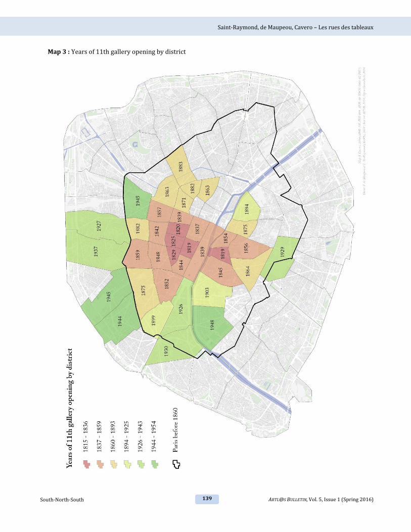
20th century alike map 2.16 In chronological
terms, we considered the average date of the
opening of the galleries in a given area alongside
the date of the opening of the eleventh gallery. As
such, only more relevant areas – those with ten or
more art dealers – were taken into account on our
maps. The inclusion of areas with just a few
galleries alongside major artistic centres would
have biased our findings by constituting a form of
background interference. Similarly, we chose to
disregard mean opening dates that resulted from
particularly large intervals between gallery
openings – in other words, a particularly high
standard deviation17 – as in this case the resulting
opening year was of little real meaning.18 Finally,
the date of the eleventh gallery opening was
included as a measure of the statistical relevance
of an area. A summary of this information is given
in map 3 and in the following graph figure 1.
The map reflects both the expansion of the city
and the spatio-temporal evolutions of its art
15 Bernard Marchand, Paris: histoire d’une ville (Paris: Seuil, 1993), 52. 16 Established by the loi du 16 juin 1859, these districts correspond to the 48 revolutionary sectors created in 1790 – now referred to as quartiers – along with the 32 additional quartiers that were added to the city with its extension. Today they are still used by Paris’ police force. 17 This threshold of relevance refers to the median standard deviation. We also chose to disregard average dates of establishment whose standard deviation was greater than 30 years. 18 For example, the establishment of gallery spaces in Saint-Germain-des-Prés occurred over two distinct periods and the neighbourhood’s average establishment date – 1897 – has little meaning as it does not reflect this historical reality.

Saint-Raymond, de Maupeou, Cavero – Les rues des tableaux
122 South-North-South ARTL@S BULLETIN, Vol. 5, Issue 1 (Spring 2016)
dealers. The graph meanwhile shows the pivotal
moments when the stable population of galleries
suddenly increased, and allows us to define the
key periods of spatio-temporal evolution figure
1. 1860 is the only date that we manually inserted
to this graph, in light of the importance of this year
in Paris’ history: it was in this year that the city
took on its present form consisting of twenty
arrondissements. In this way, we established six
periods: 1815-1836, 1837-1859, 1860-1893,
1894-1925, 1926-1943 and, 1944-1954.
Using this periodization, we created two types of
cartographic representations: ‘stock maps,’ which
show the number of galleries operating between
two given dates, and ‘flow maps,’ which show the
net change of an area in terms of the number of
galleries gained or lost. An automatic data
processing model enabled us quickly generate our
results and verify the relevance of the periods we
had proposed.19 The same model was used to treat
smaller, local data sets for the rue de Seine, rue
Laffitte and rue La Boétie.
The choice of these streets and the corresponding
change of scale was not arbitrary: in existing
literature on art dealers, these areas are identified
as the main rues des tableaux, an observation
confirmed by our spatial analysis of gallery
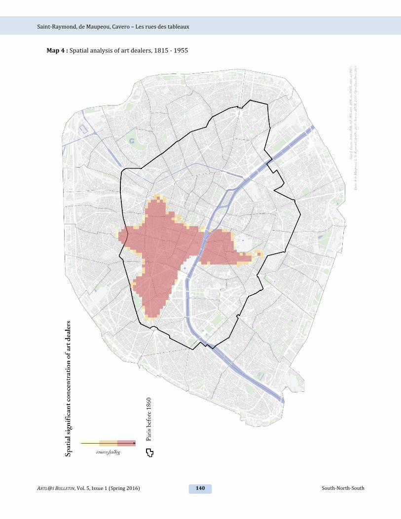
‘hotspots’. This method identifies statistically
significant spaces and organizes them into squares
measuring 100m2 each. The result is a map that
shows the zones with a spatially significant
concentration of art dealers. While the map of 19 Model based on the chronological selections and spatial statistics of the ArcGIS Model Builder.
hotspots across the entire period map 4 presents
a largely familiar set of locations, more complex
dynamics can emerge when our periodization is
applied map 23.
Art Dealers and their Spaces
(1815-1860)
1815-1836: Between the Institut and the Palais-
Royal
An early cluster of art dealers formed on the left
bank around the collège des Quatre-Nations map
5. Since 1805, Louis Le Vau’s domed building had
housed the Institut de France. Founded in 1795
following the revolution, the Institut brought
together five existing academies, including the
Académie des Beaux-arts that was created in 1816
to replace the Académie royale de peinture et de
sculpture. That same year, the École des Beaux-
arts was established and housed in the former
Petits-Augustins convent that was then occupied
by the Musée des Monuments Français. The
northern end of rue du Seine that opens onto the
river, quickly became a favourite area for art
dealers. The importance of this street and in
particular its northern section is clear on map 7.
Between 1815 and 1836, it was home to five art
dealers: Berthon, Jacquinot, Saint Martin, Mennier
and Madame Girard. In these early years of the
19th century, the Parisian artistic scene was still
dominated by powerful official institutions.
Though art dealers would eventually make their
presence felt, at this early stage they were still
Figure 1 Definition of the pivotal periods in the geography of the art market, from the annual number of districts
where the eleventh gallery appeared (in black) and from the significant average dates of the opening of the eleventh gallery (in red)

Saint-Raymond, de Maupeou, Cavero – Les rues des tableaux
123 ARTL@S BULLETIN, Vol. 5, Issue 1 (Spring 2016) South-North-South
largely dependent on the institutional system and
so tended to stay close to its centres.
In this period, with a significant art market yet to
take form, gallerists where overwhelmingly
located on right bank: almost 80% operated there.
Across the river from the rue du Seine, a second
cluster of art dealers could be found around the
Louvre, the Palais-Royal and the church of Saint-
Germain-l’Auxerrois. Between 1815 and 1836, the
districts of Palais-Royal, Mail, and Vivienne saw a
marked development, with 55 gallery openings
against 45 closures map 6. The concentration of
gallerists can be explained by the economic and
social appeal of the Palais-Royal, “the most
famous, most central, and most lively area of Paris
for half a century between 1786 and 1830.”20
Though it was home to finance, fashion, and luxury
traders, the area’s main economic activity focused
around the book trade: the presence of the literary
scene proved to be a draw and galleries clustered
around the Palais. The neighbourhood’s
association with the arts went beyond economic
concerns: the galerie du Palais-Royal had been
home to the Salon until it moved to the Louvre in
1699. In 1815, the first year of our analysis, an art
dealer by the name of M. Chaise was already in
business at 61 galerie de Pierre inside the Palais-
Royal, and was soon followed in 1817 by Monfort
in the galerie de Bois and in 1820 by Allain in the
galerie Vitrée.
The neighbourhood immediately surrounding the
Palais was also populated by art dealers. The most
prestigious of them was Alphonse Giroux, whose
address is listed in the Bottin du commerce as 7 rue
Coq Saint-Honoré from 1816 to 1849.21 This
painter and dealer, who had worked on the
restoration of Notre-Dame, played a central role in
the development of the trade in modern painting
between 1820 and 1830.22 J. Vigny, meanwhile,
operated out of the passage Delorme until 1820.
Established in 1808, this luxurious arcade opened
20 Bertrand Lemoine, Les passages couverts en France (Paris: Délégation à l’Action Artistique de la Ville de Paris, 1990), 71. 21 Currently the rue de Marengo, running between the Louvre and the Palais-Royal, perpendicular to the rue de Rivoli. 22 Linda Whiteley, “Art et commerce d’art en France avant l’époque impressionniste,” Romantisme 13, no. 40 (1983), 66.
onto the pavillon de Marsan and was also home to
fashion and curiosity boutiques until it became
less frequented around 1828.23
The end of the 1820s and the establishment of the
July Monarchy saw a first move towards the
northwest, one which continued progressively
with the modifications of the capital. It was the
construction of covered arcades that spurred this
first shift. Between 1823 and 1828, no less than
twenty new arcades were built, including some of
the city’s most prestigious: Grand Cerf, Choiseul,
Colbert, along with the galleries Véro-Dodat and
Vivienne.24 While Walter Benjamin considered
that “the first condition for their emergence is the
boom in the textile trade”25 the arcades were also
an important location for the bourgeoning art
trade. From the end of the 1820s, art dealers were
drawn to this new economic centre to the north of
the Palais-Royal. Its focal point was the rue
Vivienne, the historic centre of banking and money
changing activities.26 The passage Choiseul clearly
demonstrates the area’s appeal: opened in 1827,
five art dealers opened their doors there in the
space of five years. H. Gaugain opened in the
galerie Colbert, in 1830, three years after the
arcade’s inauguration. The economic shift towards
the northwest was decisively accelerated in 1836
with the imposition of a ban on gambling: “From
then on, the decline of the Palais-Royal was
rapid. Dandies, strollers, pleasure seekers and girls
emigrated several hundred meters away, towards
the Boulevard and the new enchanted
promenade.”27
1837-1859: Conquering the Boulevard
As map 8 shows, the following period was
characterized by two parallel phenomena. On the
one hand, the number of art dealers grew
significantly, with 391 new galleries opening over
the period, and eleven districts reached or passed
23 Lemoine, Les passages couverts en France, 105. 24 Lemoine, Les passages couverts en France, 26. 25 Walter Benjamin, The Arcades Project (Cambridge: Harvard University Press, 1999), 3 26 Louis-Sébastien Mercier, Le tableau de Paris, (Paris: La Découverte, 2008), 86. 27 Eric Hazan, L’invention de Paris. Il n’y a pas de pas perdus, (Paris: Éditions du Seuil, 2008), 40.

Saint-Raymond, de Maupeou, Cavero – Les rues des tableaux
124 South-North-South ARTL@S BULLETIN, Vol. 5, Issue 1 (Spring 2016)
the eleventh gallery milestone. These figures,
higher than any other period, reflect the pivotal
nature of this period. At the same time, the cluster
of galleries to the northwest of the Palais-Royal
became more dense with the popularity of the
arcades and the Boulevard. Indeed the Boulevard
was home to a new artistic area around the Opera
– then at 12 rue Le Peletier –, the boulevard des
Italiens and the boulevard des Capucines. ‘The
Boulevard’ at this time referred specifically to the
boulevard des Italiens, whose reputation for
elegance dated from the time of the Directoire and
which saw it become synonymous with “a style of
sociability in which men of the world
participated.”28 Under the July Monarchy, these
military structures – a boulevard originally
designated the parade ground beneath a rampart –
became models for major thoroughfares, elegant
roads planted with trees and home to numerous
businesses, cafés, and luxury boutiques.29 The
centre of fashionable life moved further north-
westwards, to the section of the boulevard des
Italiens known as ‘boulevard de Gand’; it was in
the town of Gand that Louis XVIII had spent the
Cent-Jours, and the boulevard’s moniker was a
reference to the émigrés who flocked there after
the king’s Restoration.30 The boulevard de Gand
referred specifically to the northern section of the
boulevard des Italiens between the Madeleine and
the rue Taitbout.31 On the corners where the rue
Taitbout met the boulevard, Le Café Tortoni,
founded in 1804, faced off with the Café de Paris,
which opened its doors in 1822. Another
important address in the area’s social life was La
Maison Dorée, a restaurant that opened in 1840 at
20 boulevard des Italiens. The gentlemen of the
boulevard de Gand also rubbed shoulders at
circles such as the Union, the Jockey Club and the
Cercle agricole. The appeal of the Boulevard was
28 Anne Martin-Fugier, La vie élégante ou La formation du Tout-Paris : 1815-1848, (Paris: Perrin, 2011), 430. 29 Anne-Marie Châtelet, « Formation et transformation des grands boulevards », La modernité avant Haussmann : formes de l’espace urbain à Paris 1801-1853, ed. Karen Bowie (Paris, Éditions Recherches, 2001). 30 Marchand, Paris: histoire d’une ville, 46. 31 Martin-Fugier, La vie élégante ou La formation du Tout-Paris : 1815-1848., 430.
further bolstered with the completion of the Église
de la Madeleine in 1842.32
Offering all the commercial and leisure activities
that made Paris a modern capital, this new
neighbourhood formed around the Faubourg
Montmartre and the Chaussée-d’Antin was
frequented by the kind of bourgeois flâneur who
was likely to purchase works of art.
Art dealers recognized the appeal of the area and
soon moved in map 9. The Faubourg Montmartre
district passed the eleven gallery threshold in
1842, with the Chaussée-d’Antin following shortly
after in 1848 map 3. Amongst the
neighbourhood’s new arrivals was Adolphe
Beugniet, who set up his restoration business in
1842 at 10 rue Lafitte, before opening his gallery
at number 18 in 1848. Beugniet thus became the
first art dealer on the rue Lafitte, which saw 13
openings and 8 closings over this period map 10.
The trajectory of Jean-Marie-Fortuné Durand-Ruel,
the father of the famous art dealer Paul Durand-
Ruel, also attests to this geographic shift. He first
went into business with a stationery shop on rue
Saint-Jacques in the left bank’s Latin Quarter, “a
part of the city inhabited for the most part by
students but largely unfavourable to luxury
businesses due to its distance from Paris’ wealthy
neighbourhoods.”33 As his business flourished,
Durand-Ruel senior decided to join the art trade.
In order to do so, he had to “move towards the
neighbourhoods inhabited by his customers and
the city’s wealthier inhabitants, who might be
interested in his acquisitions.”34 It was in 1837
that he opened a branch on the right bank at 103
rue Neuve des Petits Champs, the street bordering
the Palais-Royal to the north. In 1843, increases to
his rent led him to relocate to number 83 on the
same street. Though apparently a fairly
inconsequential move, Durand-Ruel’s finances
suffered in the new and less visible location,
despite its increased size and more reasonable
32 “[…] many traders left the historic centre and opened their businesses around the Madeleine […]”, Marchand, Paris: histoire d’une ville, 53. 33 Paul Durand-Ruel, "Mémoires de Paul Durand-Ruel" in Les archives de l’impressionnisme, ed. Lionello Venturi (Paris and New York: Durand-Ruel, 1939), 2: 151. 34 Durand-Ruel, "Mémoires de Paul Durand-Ruel," 151.

Saint-Raymond, de Maupeou, Cavero – Les rues des tableaux
125 ARTL@S BULLETIN, Vol. 5, Issue 1 (Spring 2016) South-North-South
rent.35 This episode provides a minor but telling
example of the importance of geographic location
for economic success. As his business ebbed away,
in 1847 Durand-Ruel chose to take a gamble and
rented a second space in “the busiest spot in the
Paris, thronging with stockbrokers and
foreigners”36: boulevard des Italiens. Yet the rent
on the Boulevard soon proved to be too expensive,
and the gallery closed after just two years with
Durand-Ruel maintaining his boutique on rue
Neuve des Petits Champs. Despite this failure,
Durand-Ruel’s trajectory pointed towards a
general trend from the Palais-Royal to the
Boulevard.
However, this spatial shift set in with a slight
delay: it was not until 1852, some ten years after
the completion of the Église de la Madeleine, that
the Madeleine district passed the eleven gallery
threshold. Indeed this lag may be observed across
the whole period, and puts the importance of the
art market into perspective, showing that despite a
booming trade, dealers tended to follow economic
shifts rather than drive them. It was only in the
second half of the 20th century that the art market
became a decisive force in the development of a
district. This was the case in the 1970s, for
example, when a series of influential galleries –
Daniel Templon, Alain Blondel, François Palluel
and the Galerie Beaubourg – set up in the
Beaubourg neighbourhood, anticipating the
opening of the Centre Georges Pompidou in
1977.37
While the draw of the Boulevard between 1837
and 1859 was undeniable, more subtle dynamics
were also at work. The appeal of the Boulevard
spread to surrounding areas, including Vendôme
and especially Madeleine. The art market’s growth
on the right bank was paralleled by a similar
development of the left bank, though the
asymmetry between the two was not yet quite so
marked as it would be in years to come. The École
35 In 1843, my father … made the grave error of leaving behind his boutique where business was prospering for another location, almost directly opposite at n° 83. Though larger and quite affordable, this boutique was much less visible.” Durand-Ruel, "Mémoires de Paul Durand-Ruel," 153. 36 Durand-Ruel, "Mémoires de Paul Durand-Ruel," 154. 37 Félicie de Maupeou and Léa Saint-Raymond, 'Cartographie des lieux d’exposition à Paris, de 1850 à nos jours', Artl@s Bulletin 1, no. 1 (Fall 2012), 6.
des Beaux-arts and the Institut continued to
ensure the popularity of the Saint-Germain-des-
Prés district, where 35 openings offset 30 closings
map 9. Amongst the most influential of the left
bank dealers was Eude dit Michel jeune, who
operated a gallery at 12 rue de Seine between
1839 and 1850 before opening another at 2 rue
des Beaux-Arts from 1843 until 1845. However,
where the growing popularity of the Chaussée
d’Antin benefited surrounding neighbourhoods on
the right bank, on the left bank galleries rarely
strayed beyond a more or less fixed perimeter. To
give just one example Malinet was listed in the
Bottin du commerce as an art dealer operating at 9
quai Voltaire between 1846 and 1848, and later at
number 25 between 1854 and 1887. He also
appeared under in the marchand de curiosités
category during the same period; it was for this
latter activity, and in particular his trade in
chinoiseries and japoneries, that Malinet was best
known.38
The Formation of Hotspots (1860-
1923)
1860-1893: “One simply must go to rue Laffitte”39
Following a frenetic development that saw the
number of galleries in Paris double, the 1860s
ushered in a period of gradual stabilisation. 1860
is a key date for the study of Paris’ history, as it
was in this year that the city grew from twelve to
twenty arrondissements with the annexation of
peripheral urban areas. The 400,000 new
inhabitants represented not only a major
population increase but also a boon to the city’s
finances.40 This dramatic change was accompanied
by the major works carried out by Baron
Haussmann, who had been named prefect of the
Seine on 23rd June 1853 and had wasted little time
38 Manuella Moscatiello, “A craze for auctions. Japanese art on sale in 19th century Paris”, Andon, 90 (2011), 22-45. Léa Saint-Raymond, “Les collectionneurs d’art asiatique à Paris (1858-1939): une analyse socio-économique”, in Orient-Extrême: regards croisés sur les collections modernes et contemporaines, ed. Véronique Alexandre Journeau (Paris: L’Harmattan, to be published). 39 “Il est bon d’aller rue Laffitte”, Ambroise Vollard, Souvenirs d’un marchand de tableaux (Paris: Albin Michel, 2007), 83. 40 Nathalie Montel, "L’agrandissement de Paris en 1860 : un projet controversé," in Agrandir Paris 1860-1970, ed. Florence Bourillon and Annie Fourcaut (Paris: Publications de la Sorbonne / Comité d’histoire de la Ville de Paris, 2012), 99-111.

Saint-Raymond, de Maupeou, Cavero – Les rues des tableaux
126 South-North-South ARTL@S BULLETIN, Vol. 5, Issue 1 (Spring 2016)
in acting upon the “plan colorié” drawn up by
Napoleon III.41 A decree signed into law on 26th
March 1852 allowed for the expropriation of land
that ran alongside streets that were to be
extended; Haussmann was thus able to extend
roadways straight through the urban fabric, rather
than widening existing streets. The city, “hacked
apart as if by a sabre, its veins wide open”42 was
forever changed by Haussmann’s programme.
The most intense period of haussmannization ran
from 1853 to 1859 and is reflected in Figure 2,
which shows the number of new streets and
sections of boulevard created annually.
Figure 2. Number of new streets and sections of boulevard decreed annually43
By 1860, the most significant decisions as to the
city’s layout had been taken, though the works
would continue for many years, making their
presence felt as late as the turn of the 20th
century.44 The dramatic changes brought about by
haussmannization increased the appeal of western
Paris. The first concessions were located in the
peripheral western areas that tended to be less
built-up and therefore less expensive, as well as
being more attractive to a wealthy clientele.45 This
shift towards the west was further encouraged by
the new site of the new Opera, which was declared
in 1860 and lay west of the existing opera house
41 This map was unfortunately lost when the Hôtel de Ville was burned down in 1871 in the last days of the Paris commune. 42 Emile Zola, La Curée (Paris: Gallimard, 2013), 114 43 Graph created using data drawn from Pierre Pinon, Atlas du Paris haussmannien. La ville en héritage du Second Empire à nos jours (Paris: Parigramme, 2003), 200-201. 44 “Haussmann’s works were still being completed: the rue Réaumur, decreed in 1864, was opened in 1895, to allow for the construction of the metro. The boulevard Haussmann, which was to link Opéra to the Drouot junction, was only completed in 1926. After 1889 came the southern ringroad of the rue de la Convention, towards Alésia and Tolbiac. The boulevard Raspail was completed in 1911. Haussmann’s legacy seemed to be never ending.” Marchand, Paris: histoire d’une ville, 171. 45 Pinon, Atlas du Paris haussmannien. La ville en héritage du Second Empire à nos jours, 62.
on rue Le Peletier in the triangle formed by rue
Caumartin, the boulevard des Italiens and the
boulevard Montmartre.46 Finally, the enlargement
of the gare Saint-Lazare further shifted the city’s
centre of gravity towards the 8th arrondissement.
The station was created in 1837 with the opening
of the railway line between Paris and Saint-
Germain-en-Laye. Its development continued
apace until 1867, when a final extension was
carried out to accommodate the crowds arriving in
the city for the World Fair. With the city rapidly
expanding towards the north-west, galleries
struggled to keep up, as shown on the maps 11 and
12. While the Chaussée-d’Antin district dominates
these maps, Europe and Saint-Georges continue to
gain ground in a movement that would reach its
peak in the 20th century.
The growing importance of the 9th arrondissement
was noted by guides to the city:
Visiting the various districts of the arrondissement,
one can easily notice the distinguishing
characteristics of each; our comments above apply
in particular to the Chaussée-d’Antin district; to
complete the picture of the arrondissement, we need
only mention the numerous displays that line the
boulevard Haussmann and rue Lafitte, rue Taitbout
and rue Châteaudun. Paintings, gouaches,
watercolours, drawings, medals, autographs,
bronzes, faiences, rifles, antique furniture abound in
the shop windows of these streets, transforming
them into a sort of museum of curiosities. 47
The emblematic history of the galerie Durand-Ruel
can help us to better understand the draw of the
9th arrondissement. In 1858, Jean-Marie-Honoré
Durand-Ruel left the rue des Petits-Champs to
open a new gallery further to the west, on the
prestigious rue de la Paix. When Paul Durand-Ruel
took over the family business from his father, he
began to look for a larger space that could
accommodate exhibitions of work by the painters
he was championing. He considered taking over
Martinet’s former galleries on the boulevard des
Italiens, only to decide upon a site between rue
46 Marchand, Paris: histoire d’une ville, 83. 47 Alexis Martin, Paris. Promenades dans les vingt arrondissements (Paris: A. Hennuyer, 1890), 168-169.

Saint-Raymond, de Maupeou, Cavero – Les rues des tableaux
127 ARTL@S BULLETIN, Vol. 5, Issue 1 (Spring 2016) South-North-South
Laffitte and rue Le Peletier.48 This choice proved to
be an unfortunate one, by the gallerist’s own
admission:
Leaving behind my wonderful boutique on the rue
de la Paix was a major error that I would pay for
with twenty-five years of terrible suffering. To this
day I cannot understand why I made such a mistake,
since I ought to have seen that the magnificently
placed rue de la Paix had immediately led our
business to thrive and prosper. Indeed it had proved
to be my parents’ salvation following the precarious
years of their disastrously located gallery on the rue
des Petits-Champs.49
Durand-Ruel suggested that his new location was
disappointing in large part due to its distance from
the boulevard des Italiens, which was very much
the centre of business and the place to see and be
seen.
However, Durand-Ruel’s complaint seems to run
entirely contrary to our own analysis. The rue
Lafitte, where art dealers had begun to move in the
previous period, became a major centre from 1860
onwards, as our enlargement map 13 shows. It
also benefitted from the immediate proximity of
the auction house on the rue Drouot, which
opened on 1852. The ground floor of almost every
even-numbered building on the street was
occupied by an art dealer: Antoine Baer at n°2,
Simon Cahen at n°20 then n°6, Berneim Jeune at
n°8, Beugniet at n°10, Gérard at n°12, Durand-Ruel
at n°16, Hector Brame at n°22 from 1892 to 1894,
Fréderic Reitlinger at n°22 bis for a short spell in
1879, Tamplaère at n°28 and Wildenstein at n°56
between 1885 and 1892. On the other side of the
street, Détrimont ran a gallery at n°33 between
1856 and 1871 before moving to n°27 between
1873 and 1888. N°15 proved particularly popular,
playing host to five different art dealers between
48 Durand-Ruel is listed in the Bottin du commerce at 16, rue Laffitte and at 11, rue Le Peletier, between 1871 and 1877, then again between 1888 and 1925. Between 1880 and 1887, his address reverts to 1, rue de la Paix. In 1882, Durand-Ruel had sublet his premises on the rue Le Peletier to the Banque Nationale. When he resumed his tenancy on rue Le Peletier in 1887, he let out rue de la Paix. Paul Durand-Ruel, le pari de l’impressionnisme, exhibition catalogue, ed. Sylvie Patry, (Paris: Musée du Luxembourg / RMN, 2014), 200 - 204. 49 “It was a great error on my part to have abandoned my attempts to rent a galerie on the boulevards des Italiens, frequented by foreigners and all of Paris’ wealthy citizens, and instead to have rented a premises far from the boulevard whose two entrances opened onto quiet streets.” Durand-Ruel, "Mémoires de Paul Durand-Ruel," 173-174.
1860 and 1893: Weil, Duval, Suret, Cornu and
Tinardon.
Figure 3. The rue Laffitte around 1900, with an enlargement showing an art dealer’s
sign. (Collection: L. Saint-Raymond)
There was a general consensus that, during the
halcyon days of Impressionism between 1870 and
1880, the rue Lafitte was an epicentre of artistic
life50, thanks to its position between the Chaussée
d’Antin and Faubourg Montmartre districts. Art
dealer Ambroise Vollard would later recall the
street’s golden age:
At the time, rue Laffitte was la rue des tableaux. If
one heard someone say “I shall take a turn around
rue Laffitte”, one could be sure that the person in
question was an amateur of painting. In the same
way, when Manet said “one simply must go to rue
Laffitte”, or when Claude Monet asked “Why go to
rue Lafitte?”, this meant that the painter felt it was
either necessary or of little interest to stay up to date
with the work of his peers.51
Furthermore, the success that Durand-Ruel would
ultimately enjoy seems to dispel the sombre image
50 Véronique Chagnon-Burke, “Rue Laffitte: Looking at and Buying Contemporary Art in Mid- Nineteenth-Century Paris,” Nineteenth-Century Art Worldwide 11, no. 2 (Summer 2012), accessed January 13, 2016, http://www.19thc-artworldwide.org/summer12/veronique-chagnon- burke-looking-at-and-buying-contemporary-art-in-mid-nineteenth-century-paris 51 Vollard, Souvenirs d’un marchand de tableaux, 83.

Saint-Raymond, de Maupeou, Cavero – Les rues des tableaux
128 South-North-South ARTL@S BULLETIN, Vol. 5, Issue 1 (Spring 2016)
he gave in his account of the rue Laffitte. It seems
far more likely that his business tribulations in the
1870s were the result of his artistic choices and
broader economic hardship rather than
geographic location. Durand-Ruel invested heavily
in Impressionist paintings at a time when their
revolutionary style had yet to find favour with
most buyers, while in 1882 the collapse of the
Union générale bank and subsequent stock market
crash pushed him close to bankruptcy. Beginning
that same year, he also faced serious competition
from Georges Petit, who opened a new gallery on
rue de Sèze. Petit benefited from a more desirable
location closer to the Madeleine and furthermore
distinguished by “the luxury of the gallery which is
rather beautiful and impresses the crowds.”52
Durand-Ruel considered a return to rue de la Paix,
but abandoned this location definitively in 1888 in
favour of his space between rue Laffitte and rue Le
Peletier, where he would stay until 1924. The
longevity of this gallery suggests that despite his
exasperation, Paul Durand-Ruel’s choice was a
fortuitous one, and that the neighbourhood proved
to be a favourable commercial environment.
Not all art dealers would follow the westward
movement over the years of change brought about
by haussmannization. The city’s eastern areas had
taken advantage of a window of opportunity at the
turn of the century, albeit one that was short-lived
and did not last into the next period map 11.
Thirty or so art dealers went into business in the
districts surrounding the place de la République
between 1860 and 1893. This new cohort is
particularly visible in map 3: the Archives and
Porte Saint-Martin districts passed the eleven
gallery mark in 1863, followed by Arts et Métiers
in 1871, Enfants-Rouges in 1882 and Folie-
Méricourt in 1883. There the most attractive
streets were the rue du faubourg Saint-Denis,
52 Letter from Claude Monet to Durand-Ruel [Poissy, 23 December 1882] samedi matin. Letter reprinted in Daniel Wildenstein, Monet: catalogue raisonné (Köln Lausanne: Taschen Wildenstein Institute, 1996), 5, letter 305. The painter’s account is corroborated by that of Alexis Martin in Alexis Martin, op. cit, p. 208 "At 8 rue de Sèze can be found the elegant peristyle of Georges Petit's gallery, topped with a golden cupola … Without a doubt, this gallery is the city's finest exhibition hall. A bright corridor with high ceilings and walls that are often lined with drawings or engravings leads to a wide staircase up to the gallery. This vast room measures 25 meters one way and 15 the other; it is carpeted with red rep, furnished with sofas and armchairs, decorated with planters; the light enters from above, and is softened by an immense piece of vellum."
home to eight galleries, followed by the rue du
Château d’Eau and the boulevard Beaumarchais
with five each. Though the presence of these
eastern galleries provides some nuance to the
overall picture, they did not challenge the
dominance of the Parisian west. Art dealers
located in the east tended to stay in business for
shorter periods of time than their counterparts on
the rue Laffitte, and the ‘star’ galleries were all
located in the 9th arrondissement. What’s more,
galleries were far less numerous in these districts
in the following period map 23. These eastern
districts and thus cannot therefore be considered
as a durable presence within the Parisian art
market.
A comparison of the maps showing the locations of
galleries and the openings and closings also
reveals a number of aspects of the market on the
left bank in this period. The first map 11 points
to the durability of the Saint-Germain-des-Prés
district. Yet the overall turnover in this period
resulted in a net loss, with 46 openings against 49
closings map 12. A close look at the capital’s
three major streets confirms this trend map 13.
The overall number of galleries drops and they
seem to become concentrated in smaller areas,
moving as close as possible to the Institute and the
École des Beaux-arts despite the flagging status of
these academic institutions.
1894 – 1925: Towards Rue La Boétie
The collapse of the left bank was confirmed
between 1894 and 1925 as the asymmetry with
the right bank became ever more marked map
14. Activity in the Saint-Thomas-d’Aquin district
had been dwindling since the previous period, and
now stabilized at a relatively low level: we
identified nine art dealers in this area over the
period, with seven openings and eight closings.
Saint-Germain-des-Prés meanwhile managed to
make a net gain, albeit a modest one: nineteen
galleries opened while fourteen closed map 15.
After a tentative outward expansion, the galleries
quickly returned to the rue de Seine and the

Saint-Raymond, de Maupeou, Cavero – Les rues des tableaux
129 ARTL@S BULLETIN, Vol. 5, Issue 1 (Spring 2016) South-North-South
streets which immediately surrounded it. The turn
of the 20th century marked the definitive collapse
of the institutional system, and with it the local art
market; the net growth can be explained by the
opening of the boulevard Raspail in 1911 which
lent a new dynamism to the Notre-Dame-des-
Champs district.53 However, this change was not to
make itself fully felt until the following period.
The right bank was marked by a number of
simultaneous phenomena. The historical centre of
the Chaussée d’Antin further cemented its
dominance map 15. As Vollard would later recall,
the rue Laffitte retained its appeal even for a new
generation of younger artists at the turn of the
century: “it was for all these young painters, a
place of pilgrimage. How many times could one
spot Derain, Matisse, Picasso, Rouault, Vlaminck
and others on the rue Laffitte ?”54 The close-up on
these streets shows that the massive growth on
the rue Laffitte dominates the art market map 16.
However, a closer look at the data reveals a
somewhat more complex picture. Though the
street undeniably reached its peak during this
period, with 49 openings and 53 closings, these
years also marked the beginning of its decline. The
district’s fall from grace would be swift and brutal
in the following period map 19. Vollard, a keen
observer of his times, noticed the beginning of this
decline and the rise of a new centre in the 8th
arrondissement: art dealers were flocking to the
rue La Boétie, which stretches from the avenue des
Champs-Élysées to the place Saint-Augustin,
where the boulevard Malesherbes and the
boulevard Haussmann meet.
The rue des tableaux is no longer rue Laffitte. M. Jos
Joseph Hesssel, a dealer in modern paintings, had
looked to set up business there only to find no
spaces available for rent. So he began to look
elsewhere, and settled on rue La Boétie. His business
prospered, and he was gradually joined by his fellow
53 “In 1911, the inauguration of the boulevard Raspail, one of Haussmann’s projects yet only completed 50 years after it was announced, linked the boulevard Montparnasse and the rue de Vaugirard, and changed the character of the area by giving a new importance to the Vavin crossroads. At the same time, painters began to leave Montmartre, a neighbourhood that had become a victim of its own success and was being changed by a wave of tourism.” Marchand, Paris: histoire d’une ville, 223. 54 Vollard, Souvenirs d’un marchand de tableaux, 85.
art dealers until the rue La Boétie became what the
rue Laffitte once had been: a veritable market of
painting… As one went to rue Laffitte to see the
exhibitions of Durand-Ruel, so today one goes to rue
La Boétie to see those of Paul Rosenberg.55
On the enlarged view given on map 16 , the
emergence of rue La Boétie is clearly visible, with
32 openings and 15 closings. The most popular
stretch lies between the rue du faubourg Saint-
Honoré – the Saint-Philippe du Roule crossroads –
and the boulevard Malesherbes. If in terms of
stock the rue La Boétie seems rather modest
compared to the rue Laffitte, the flow shows that
the former gained galleries in this period while the
latter saw its numbers dwindle. The gradual
transition of art dealers towards the rue La Boétie
from the rue Laffitte was seen as a reflection of
their increasingly elite social status, as gallerists
Berthe Weil would later recall:
Lepoutre, an art dealer from the rue Laffitte, is on
the up: he is opening a boutique on rue La Boétie,
and his remarkable inaugural exhibition is to feature
paintings by Utrillo… Oh, oh, but his prices have
been raised! Scandal! But such success… the moral of
this story: this charming painter has found his feet,
and the big art dealers are on the move!56
Moving to the rue de la Boétie was thus seen as a
sign of both economic and social success.
This pattern of concentration was paralleled by
one of expansion, as more and more galleries
proved willing to go into business beyond the
established frontiers of the market. The explosion
in the number of galleries partly explains this
phenomenon, as it led to a degree of overcrowding
in the historic centres of the art trade. This
phenomenon gave rise at first to a ring of galleries
around traditional areas, with art dealers settling
in the Faubourg du Roule further west and Saint-
Georges and Rochechouart to the north of the
Chaussée d’Antin and Faubourg-Montmartre
districts. This concentric expansion was an early
sign of a maturing market. Elsewhere, the 55 Vollard, Souvenirs d’un marchand de tableaux, 95. 56 Weill, Pan !... Dans l’œil !, 143.

Saint-Raymond, de Maupeou, Cavero – Les rues des tableaux
130 South-North-South ARTL@S BULLETIN, Vol. 5, Issue 1 (Spring 2016)
expansion was less regular; this was particularly
true of eastern Paris, where galleries dotted
districts as far away from the centre as Père
Lachaise, with a dealer named A. Joly opening a
boutique at 55 rue des Amandiers. In the north,
some gallerists ventured as far as Clignancourt
and the former quarries around Montmartre. The
same pattern could be seen on the left bank, where
galleries setting up in the peripheral districts of
Javel, Plaisance and Petit-Montrouge.
“Rue La Boétie… Rue de Seine ;
The Two Hubs of Modern
Painting”57 (1926-1955)
1926 – 1943: Left Bank vs. Right Bank
The differences between map 14 and map 17 are
particularly striking: the rue Laffitte seems to all
but vanish. In 1926, a new chapter in the history of
the art market began, one that would be
characterized by a concentration of art dealers on
the left bank.
The location of galleries becomes undeniably
polarized between 1926 and 1943, structured
around rue La Boétie on the right bank and rue de
Seine on the left bank map 18. 20% of Paris’ art
dealers operated to the south of the Seine until
1894, a figure that dropped to just 15% between
1894 and 1925 only to climb again to 28%
between 1926 and 1943. While the right bank
maintained its quantitative advantage, in this later
period it nonetheless faced a serious competitor in
the left bank. The rue La Boétie and the rue de
Seine are highly visible on map 17, and become
even more so on map 19. The median opening year
on rue La Boétie was 1928, and it counted a total
of 50 galleries between 1926 and 1943. The rue de
Seine, at the heart of Saint-Germain-des-Prés,
counted 79 over the same period. The dominance
of the rue Laffitte seems to well and truly be a
thing of the past, as only seven galleries remained
57 André Fage, Le collectionneur des peintres modernes. Comment acheter, comment vendre (Paris: Les Éditions pittoresques, 1930), 118.
in this period, and the seven of closings largely
outweigh the two new galleries. After 1926, those
looking to buy art or stay up to date with the latest
trends in painting “’did’ the rue de Seine, or the rue
La Boétie.”58
This grouping around two centres marked a
further move westwards, as the 8th
arrondissement replaced the 9th as the centre of
the art market. On the right bank, the art market
became an ever more elite affair, leaving behind
the commercial areas of the Chaussée d’Antin for
the wealthy districts around the Saint-Augustin
church. The Champs-Elysées gained its eleventh
gallery in 1926 map 3, the same year as the
Europe district around the gare Saint-Lazare,
while the Faubourg du Roule saw its eleventh
gallery open in 1929. The streets around the rue
de Seine were somewhat less chic than those
surrounding the rue La Boétie. Since the
Restoration, the left bank had lain on the margins
of the capital’s economic activity, and was further
isolated from the city’s wealth as
haussmannization shifted the commercial centre
of gravity to the northwest. Following the First
World War, Saint-Germain-des-Prés was home to
numerous bookshops and “low-level civil servants
working in the ministries of the faubourg Saint-
Germain, or retirees returning to live by the Seine
after forty years of exile in Montmartre.”59 The
socioeconomic disparity between the 8th and the
6th arrondissements led to a corresponding
difference in the prestige of the art dealers doing
business in each:
There is a world, he tells me, between the rue La
Boétie and the rue de Seine. Both streets are home to
the same metier. But while the socialites gather
around Saint-Augustin, here on the left bank the
bohemian airs have remained. Those who you met
on rue La Boétie are no different from those you will
meet here: more or less polite, somewhat given to
boasting yet sure of themselves all the same.60
Contemporary observers saw in this socio-
geographic disparity two different yet
58 Maurice Sachs, Chronique joyeuse et scandaleuse, (Paris: Libella, 2012), 74. 59 Ibid., 85. 60 Ibid., 63-64.

Saint-Raymond, de Maupeou, Cavero – Les rues des tableaux
131 ARTL@S BULLETIN, Vol. 5, Issue 1 (Spring 2016) South-North-South
complementary ways of valorising artists.61 The
galleries on the left bank spotted talented artists,
while those on the right bank made their
reputations. In this system, the rue de Seine
became a sort of waiting room for the rue La
Boétie:
The rue de Seine, gloomy and tortured like the life of
the bohemian, was dubbed by M. Joseph
Prudhomme “the antechamber of Glory”: doubtless
this is why it is so close to the Institut… All of today’s
fêted painters – with the exception of those who
started out on the rue Laffitte in the small boutique
of the doyenne and guardian angel of young
painters, Berthe Weil – cut their teeth on the rue de
Sine. … The rue La Boétie and faubourg Saint-
Honoré are where reputations are made and
unmade. Once they anoint a painter, he is
definitively on the up.62
The major dealers indeed operated between the
Arc de Triomphe and the Madeleine, across the
wealthy districts of the 8th arrondissement. From
1925, the galerie Durand-Ruel moved to n°37
avenue de Friedland, the artery that links
boulevard Haussmann with the place de l’Étoile to
the west. Rue La Boétie was home to a number of
famous gallerists: Paul Rosenberg opened his
business at n°21 from 1914, while Jos Hessel
operated at n°26 from 1915 to 1941,63 and Paul
Guillaume at n°59 from 1922. Georges Bernheim
meanwhile opened his gallery n°28 before moving
to 109 rue du faubourg Saint-Honoré in 1929.
Amongst the dealers of the rue de Seine, famous
for having ‘discovered’ young painters were the
gallery Carmine at n°51 from 1929, galerie Van
Laer at n°41 between 1927 and 1936, and the
galerie Zborowski at n°26 from 1928 to 1941.64
The galerie Pierre, directed by Pierre Loeb, opened
at the corner of the rue de Seine and the rue des
Beaux-Arts in 1928. Despite being less well-
heeled, the Saint-Germain-des-Prés district
outflanked the 8th arrondissement in terms of the
61 “This geographical distribution corresponded to a certain pattern of dealing”. Gee, Dealers, Critics, and Collectors of Modern Painting: Aspects of the Parisian Art Market between 1910 and 1930, 38. 62 Fage, Le collectionneur des peintres modernes. 118-124. 63 From 1935 to 1938, the art dealer and expert Jos Hessel occupied another premises at 33 rue de Naples, a street behind the Église Saint-Augustin and running parallel to the boulevard Malesherbes. 64 These examples are borrowed from Fage, Le collectionneur des peintres modernes, 118-162.
social density of artists and dealers. The right bank
had no cafés or restaurants where the different
members and strata of the artistic community
could rub shoulders; by way of contrast, La Palette,
a café opened in the 1930s at 43 rue de Seine,
provided just this kind of social space – something
attested to by the numerous paintings and palettes
given as gifts by artists to the manager which can
still be seen today.65
However, the art market over this period cannot
be reduced to the gravitation of galleries around
these two main streets. Between 1926 and 1943,
art dealers became far more dispersed than they
had been previously, readily opening on the
peripheral areas of artistic centres. In 1930, the
Chaillot district in the 16th arrondissement gained
its eleventh gallery. The western section of the 18th
arrondissement also saw a sharp increase in the
number of art dealers; it was in this area around
the Butte Montmartre that numerous bohemian
artists had gathered between 1900 and 1910, the
time of the Bateau-Lavoir. Three gallerists opened
on the place du Tertre at the heart of Montmartre
in 1925, 1931, and 1932, but remained in business
no longer than a year in each case. Gallerists found
more success on the rue des Martyrs: Mathot
occupied n° 91 from 1924 to 1950, C. Péruse, at
n°82, from 1927 to 1949. The rue Lepic, the rue
d’Orsel, and the boulevard de Clichy were
favoured by gallerists, but with less than three on
each street, this area posed no challenge to the art
market’s main epicentres.
Despite the increase in the popularity of
Montmartre, it was in fact Montparnasse that
would become the city’s artistic and cosmopolitan
heart in the interwar period.66 Dealers and
gallerists joined the artists in Montparnasse, with
a particularly marked rise from 1929 map 3]. The
majority of art dealers who settled in
Montparnasse in this period chose the boulevard
Raspail and the boulevard du Montparnasse map
17. These two boulevards intersect at the Vavin
65 Mérimée database (“immeubles protégés au titre des Monuments historiques”), reference no. PA00088495. 66 L’École de Paris, 1904-1929 : la part de l'autre, ed. Suzanne Pagé, exh. cat. (Paris: Paris-Musées, 2000).

Saint-Raymond, de Maupeou, Cavero – Les rues des tableaux
132 South-North-South ARTL@S BULLETIN, Vol. 5, Issue 1 (Spring 2016)
crossroads, whose bars and restaurants were an
important social hub for the district’s residents.
The Montparnasse art market proved to be a
particularly original one, thanks to both its artists
but also its galleries. André Fage, a contemporary
commentator, observed that the Montparnasse
galleries stood out as particularly avant-garde, not
only in terms of their artists but also their décor:
We are on the road to Montparnasse, there is no
denying it. The journey will be less long than before,
since, in what is surely a temporary paradox, this
district, now the centre of gravity, the crossroads of
modern painting the world over, is also the one with
the fewest galleries and art dealers. However, the
galleries here are far more spacious, more modern
too, and comfortably installed and decorated in the
most agreeable and straightforward style. It is only
right that Montparnasse, today at the avant-garde of
the artistic and literary movement, should offer the
best galleries.67
An invitation sent by the Galerie d’art
contemporain, installed at 135 boulevard Raspail
between 1927 and 1931, illustrates particularly
well this state of affairs. The modern typography
of the acronym complements the emphasis
proudly placed on the gallery’s left bank location
by the arrows crossing the Seine, as if leaving the
right bank behind for the new home of the avant-
garde.
Amongst the avant-garde art dealers was Jeanne
Bucher, whose business was located at 3 rue du
Cherche-Midi from 1928 to 1936, as well as
Marcelle Berr de Turique, whose gallery Le
Portique was located at 99 boulevard Raspail
between 1930 and 1933. The Montparnasse
galleries were considered as ‘launchpads’ for
avant-garde artists, and with good reason: to give
just one example, the painter Jean Souverbie
exhibited for the first time in 1926 at the Galerie
Vavin Raspail, which was located at 28 rue Vavin
from 1926 until 1934; six years later, Souverbie
was exhibiting his work on the right bank at
Bernheim-Jeune and Georges Petit. 68
67 Fage, Le collectionneur des peintres modernes, 122. 68 Source: data extraction from the ‘cartons verts galeries’ between 1919 and 1939, archives of the INHA. Léa Saint-Raymond, “Bas les masques ! Pour une relecture
Artists would also begin their careers by showing
paintings in the cafés of Montparnasse, as
evidenced by the appearance of La Rotonde – a
café – in the “art dealers” section of the Bottin du
commerce between 1926 and 1927. Like La
Palette, the walls of this bar were “decked with
paintings, watercolours and drawings.”69 These
cafés and others doubled, without a doubt, as
informal exhibition spaces, but as a source the
Bottin does not account for them.
Figure 4. Invitation card from the Galerie d’art contemporain, 135, boulevard Raspail. Between 1927 and 1931. (Bibliothèque de l’INHA, « cartons verts galeries », photograph: Léa Saint-Raymond)
1944 – 1955: Ongoing Duality
The distribution and nature of art dealers
remained relatively static in the period between
the liberation of Paris and 1955 maps 21 and 22.
socio-économique du Montparnasse des années 1920,” Artl@s Bulletin 4, 2 (Fall 2015). 69 Charles Oulmont, Paris. Ce qu’on y voit, ce qu’on y entend (Paris: Berger-Levrault, 1931), 45.

Saint-Raymond, de Maupeou, Cavero – Les rues des tableaux
133 ARTL@S BULLETIN, Vol. 5, Issue 1 (Spring 2016) South-North-South
The interwar geography of the art market,
structured around the rue de Seine and rue La
Boétie, was further consolidated over this ten year
stretch map 22. The left bank gained some
ground, and over the period was home to 31% of
the city’s art dealers. In this, our findings differ
slightly from those of Julie Verlaine, who observes
“the two districts reaching a gradual equilibrium,
in which each was of equal importance.”70
However, it is largely due to the source which we
used for the present study that we do not observe
the same evening out of the number of galleries on
each bank: the Bottin du commerce lists all of the
city’s art dealers, whereas Julie Verlaine refers in
her work to “contemporary” art galleries, those
exhibiting recent work by living artists.71 It is also
important to note that our data from the Bottin
fails to account for the profusion of bookshop-
galleries that opened in Saint-Germain-des-Prés in
the 1950s: though artwork was regularly
displayed there, these spaces were listed in the
‘bookshops’ category of the Bottin rather than
appearing under the ‘art dealers’ heading.
While our findings diverge from those of Julie
Verlaine on this purely quantitative level, they
confirm her observations as to the concentration
of galleries around the two major poles of rue de
Seine and rue La Boétie. Abstract and figurative art
was distributed fairly evenly across both sites,
although left bank galleries nonetheless continued
to be associated to a certain degree with the avant-
garde by virtue of their geographic proximity to its
artistic centre.72 Galleries displaying figurative art
could indeed be found along the rue de Seine and
in neighbouring streets over this period: the
galerie Chardin at 36 rue de Seine from 1946, and
the galerie Bernier at 10 rue Jacques Collot, for
example. On the right bank, meanwhile, Denise
René opened her avant-garde gallery in 1950 at
124 rue La Boétie. Without proposing an analysis
of what was going on within the walls of Parisian
70 Verlaine, Les galeries d’art contemporain à Paris, 225. 71 ‘Liste des galeries’ section from the weekly publication, Arts, from 1952 to 1965 ; Francis Spar, Annuaire du collectionneur : répertoire des prix des tableaux, peintures, livres, objets d’art, Paris Diffusion artistique et Documentaire, 1948, 1949, 1950 & 1951 ; Max Fourny, “Les galeries, leurs peintres, sculpteurs et graveurs. Annuaire 1961 des galeries,” Art et Industrie, 1962. 72 Verlaine, Les galeries d’art contemporain à Paris, 238-239.
galleries – those interested should refer to Julie
Verlaine’s thesis – we will nonetheless offer a
summary of the spatial shifts in their distribution
between 1944 and 1955.
Two phenomena stand out during this ten year
period. Firstly, the emergence of the boulevard
Raspail as an artistic thoroughfare map 20:
between 1944 and 1955, nineteen art dealers
operated there, all of them along the stretch that
lay inside of the 6th arrondissement. Secondly, the
movement of galleries towards the periphery that
could be seen at the start of the century continues
and accelerates after the liberation of Paris map
3. The upscale districts of Gros Caillou in the
western 7th arrondissement and the Plaine
Monceau in the 17th arrondissement gained their
eleventh art dealers in 1948 and 1944
respectively. Two other districts also attracted a
number of galleries, despite being less well-heeled:
Batignolles, also in the 17th, and formerly home to
a large contingent of artists in the 19th century,
and Saint-Vincent de Paul in the 10th
arrondissement. Rue Legendre and rue de
Maubeuge proved to be the respective centres for
art dealers in each arrondissement.
The appeal of Montmartre, first visible in the
1920s, continued apace, with the rue Norvins
becoming the district’s centre for the art trade:
seven galleries opened there between 1944 and
1955. However, even Montmartre could only
slightly offset the market’s two major poles, and in
fact lost more dealer-gallerists than it gained over
this period map 21. Furthermore, judging by the
names of galleries alone, the Montmartre art
market seems to have become increasingly
specialized in chromos over this period. The rue
Lepic alone counted three boutiques specializing
in older, more folkloric work rather than more
avant-garde painting: Au Vieux Montmartre
opened in 1945 and n° 91, while Montmartre de
jadis à aujourd’hui, operating at n° 102 from 1951,
was joined in 1954 by Galerie Vieux Montmartre at
n°102 ter.
Saint-Raymond, de Maupeou, Cavero – Les rues des tableaux
134 South-North-South ARTL@S BULLETIN, Vol. 5, Issue 1 (Spring 2016)
Conclusion
One hundred and forty years after it first began to
take shape, the Parisian art market had undergone
a profound transformation. From its historic base
around the Palais Royal, it had gradually shifted
northwest on the right bank to settle around the
8th arrondissement. On the left bank, meanwhile,
the artistic centre that had come into being around
the Institut de France waned along with
institutional power from the 1860s, only to return
in force from 1925.
Different analyses of artistic hotspots map 23
demonstrate the trends we have discussed above
and clearly show the art market’s evolution from a
single, concentrated centre, one that moves
progressively northwest before splitting into two
distinct poles. Our cartographic analysis thus
confirms the consensus amongst art historians as
to the distribution of galleries, yet offers a high
level of detail and draws on a large corpus. By
taking into account not only the ‘star’ galleries but
all of the art dealers listed in the Bottin du
commerce, we have been able to shed light on
some of the lesser known periods of the history of
the Parisian art market: its early development
from 1815 around the Palais Royal, its brief
incursion into the districts around place de la
République, the changes that it underwent during
haussmannization, and its installation in
Montmartre from the 1920s onwards. Our study
has also revealed the movement of galleries
towards the peripheries as early as 1894. In line
with existing historiography, we were able to
confirm and evidence the continued growth of the
art market over the entire period; at the same time
we demonstrated that this market followed rather
than drove spatio-economic tendencies, a trend
that would be reversed in the 20th century.
The results discussed in this article, which focuses
on the ‘gallery-spaces’ of art dealers, would benefit
from a further study that would take into account
‘gallery-companies’ operating simultaneously
across multiple sites, a model that was far from
rare. Such a study would retrace and analyse the
various dynamics at play – changes of address,
choice of further locations – and analyse the
consequences of geographical situation for the
longevity of these gallery-companies.
Translated from French by James Horton.

135
ARTL@S at Work
ARTL@S BULLETIN, Vol. 5, Issue 1 (Spring 2016)
Les rues des tableaux: The Geography of the Parisian Art Market 1815-1955
MAPPING ANNEX

Saint-Raymond, de Maupeou, Cavero – Les rues des tableaux
136 South-North-South ARTL@S BULLETIN, Vol. 5, Issue 1 (Spring 2016)
Map 1 : Location of art dealers, 1815 – 1955
Map 2 : Paris administrative districts
Map 3 : Years of 11th gallery opening by district
Map 4 : Spatial analysis of art dealers, 1815 - 1955
Map 5 : Location of art dealers, 1815 – 1836
Map 6 : The dynamics of art dealers in the district, 1815 – 1836
Map 7 : Art dealers located at rues de Seine, Laffitte et La Boétie, 1815 – 1836
Map 8 : Location of art dealers, 1837 – 1859
Map 9 : Dynamics of art dealers in the district, 1837 – 1859
Map 10 : Art dealers located at rue de Seine, rue Laffitte and rue La Boétie, 1837 – 1859
Map 11 : Location of art dealers, 1860 – 1893
Map 12 : Dynamics of art dealers in the district, 1860 – 1893
Map 13 : Art dealers located at rue de Seine, rue Laffitte and rue La Boétie, 1860 – 1893
Map 14 : Location of art dealers, 1894 – 1925
Map 15 : Dynamics of art dealers in the district, 1894 – 1925
Map 16 : Art dealers located at rue de Seine, rue Laffitte and rue La Boétie, 1894 – 1925
Map 17 : Location of art dealers, 1926 – 1943
Map 18 : Dynamics of art dealers in the district, 1926 – 1943
Map 19 : Art dealers located at rue de Seine, rue Laffitte and rue La Boétie, 1926 – 1943
Map 20 : Location of art dealers, 1944 – 1955
Map 21 : Dynamics of art dealers in the district, 1944 – 1955
Map 22 : Art dealers located at rue de Seine, rue Laffitte and rue La Boétie, 1944 – 1955
Map 23 : Spatial evolution of the Parisian art from 1815 through 1955

Saint-Raymond, de Maupeou, Cavero – Les rues des tableaux
137 ARTL@S BULLETIN, Vol. 5, Issue 1 (Spring 2016) South-North-South
Map 1 : Location of art dealers, 1815 – 1955

Saint-Raymond, de Maupeou, Cavero – Les rues des tableaux
138 South-North-South ARTL@S BULLETIN, Vol. 5, Issue 1 (Spring 2016)
Map 2 : Paris administrative districts
Saint-Raymond, de Maupeou, Cavero – Les rues des tableaux
139 ARTL@S BULLETIN, Vol. 5, Issue 1 (Spring 2016) South-North-South
Map 3 : Years of 11th gallery opening by district
Saint-Raymond, de Maupeou, Cavero – Les rues des tableaux
140 South-North-South ARTL@S BULLETIN, Vol. 5, Issue 1 (Spring 2016)
Map 4 : Spatial analysis of art dealers, 1815 - 1955
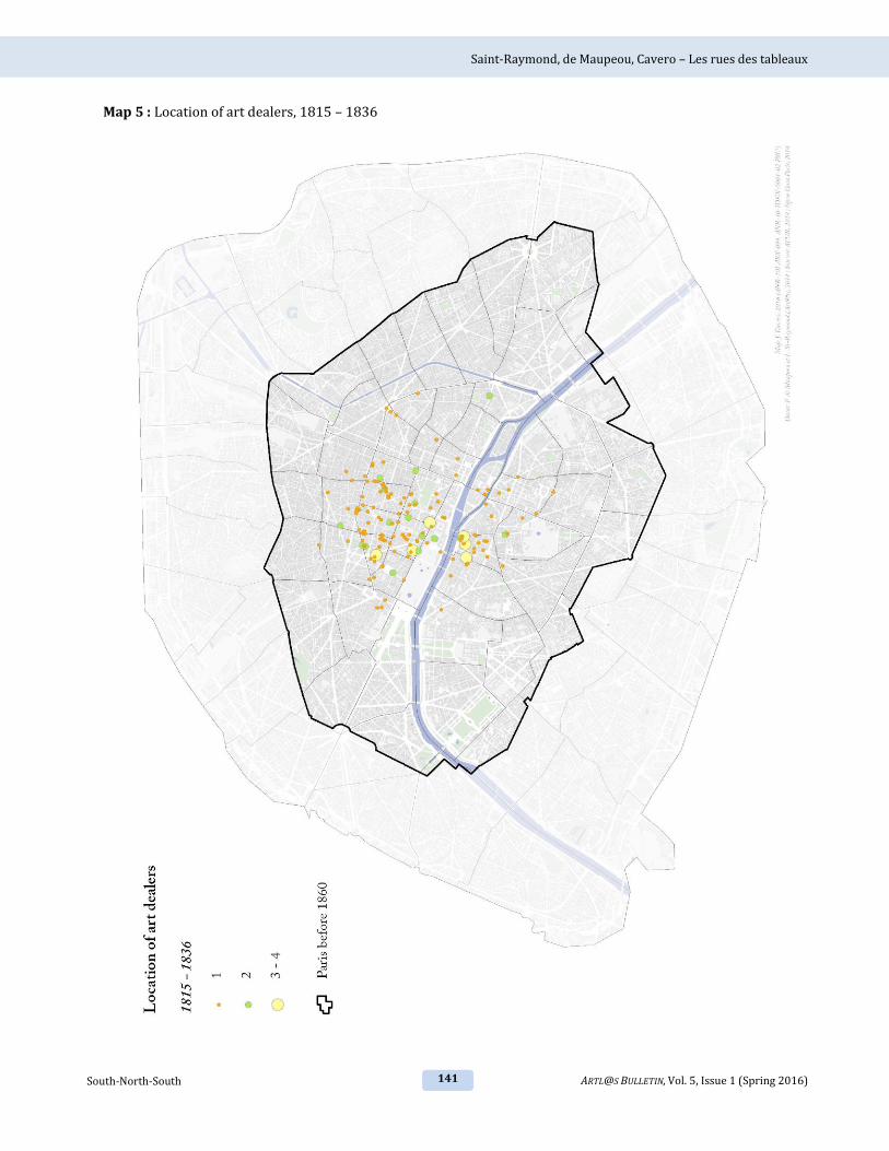
Saint-Raymond, de Maupeou, Cavero – Les rues des tableaux
141 ARTL@S BULLETIN, Vol. 5, Issue 1 (Spring 2016) South-North-South
Map 5 : Location of art dealers, 1815 – 1836

Saint-Raymond, de Maupeou, Cavero – Les rues des tableaux
142 South-North-South ARTL@S BULLETIN, Vol. 5, Issue 1 (Spring 2016)
Map 6 : The dynamics of art dealers in the district, 1815 – 1836

Saint-Raymond, de Maupeou, Cavero – Les rues des tableaux
143 ARTL@S BULLETIN, Vol. 5, Issue 1 (Spring 2016) South-North-South
Map 7 : Art dealers located at rues de Seine, Laffitte et La Boétie, 1815 – 1836

Saint-Raymond, de Maupeou, Cavero – Les rues des tableaux
144 South-North-South ARTL@S BULLETIN, Vol. 5, Issue 1 (Spring 2016)
Map 8 : Location of art dealers, 1837 – 1859

Saint-Raymond, de Maupeou, Cavero – Les rues des tableaux
145 ARTL@S BULLETIN, Vol. 5, Issue 1 (Spring 2016) South-North-South
Map 9 : Dynamics of art dealers in the district, 1837 – 1859

Saint-Raymond, de Maupeou, Cavero – Les rues des tableaux
146 South-North-South ARTL@S BULLETIN, Vol. 5, Issue 1 (Spring 2016)
Map 10 : Art dealers located at rue de Seine, rue Laffitte and rue La Boétie, 1837 – 1859

Saint-Raymond, de Maupeou, Cavero – Les rues des tableaux
147 ARTL@S BULLETIN, Vol. 5, Issue 1 (Spring 2016) South-North-South
Map 11 : Location of art dealers, 1860 – 1893

Saint-Raymond, de Maupeou, Cavero – Les rues des tableaux
148 South-North-South ARTL@S BULLETIN, Vol. 5, Issue 1 (Spring 2016)
Map 12 : Dynamics of art dealers in the district, 1860 – 1893

Saint-Raymond, de Maupeou, Cavero – Les rues des tableaux
149 ARTL@S BULLETIN, Vol. 5, Issue 1 (Spring 2016) South-North-South
Map 13 : Art dealers located at rue de Seine, rue Laffitte and rue La Boétie, 1860 – 1893

Saint-Raymond, de Maupeou, Cavero – Les rues des tableaux
150 South-North-South ARTL@S BULLETIN, Vol. 5, Issue 1 (Spring 2016)
Map 14 : Location of art dealers, 1894 – 1925

Saint-Raymond, de Maupeou, Cavero – Les rues des tableaux
151 ARTL@S BULLETIN, Vol. 5, Issue 1 (Spring 2016) South-North-South
Map 15 : Dynamics of art dealers in the district, 1894 – 1925

Saint-Raymond, de Maupeou, Cavero – Les rues des tableaux
152 South-North-South ARTL@S BULLETIN, Vol. 5, Issue 1 (Spring 2016)
Map 16 : Art dealers located at rue de Seine, rue Laffitte and rue La Boétie, 1894 – 1925

Saint-Raymond, de Maupeou, Cavero – Les rues des tableaux
153 ARTL@S BULLETIN, Vol. 5, Issue 1 (Spring 2016) South-North-South
Map 17 : Location of art dealers, 1926 – 1943

Saint-Raymond, de Maupeou, Cavero – Les rues des tableaux
154 South-North-South ARTL@S BULLETIN, Vol. 5, Issue 1 (Spring 2016)
Map 18 : Dynamics of art dealers in the district, 1926 – 1943

Saint-Raymond, de Maupeou, Cavero – Les rues des tableaux
155 ARTL@S BULLETIN, Vol. 5, Issue 1 (Spring 2016) South-North-South
Map 19 : Art dealers located at rue de Seine, rue Laffitte and rue La Boétie, 1926 – 1943

Saint-Raymond, de Maupeou, Cavero – Les rues des tableaux
156 South-North-South ARTL@S BULLETIN, Vol. 5, Issue 1 (Spring 2016)
Map 20 : Location of art dealers, 1944 – 1955

Saint-Raymond, de Maupeou, Cavero – Les rues des tableaux
157 ARTL@S BULLETIN, Vol. 5, Issue 1 (Spring 2016) South-North-South
Map 21 : Dynamics of art dealers in the district, 1944 – 1955

Saint-Raymond, de Maupeou, Cavero – Les rues des tableaux
158 South-North-South ARTL@S BULLETIN, Vol. 5, Issue 1 (Spring 2016)
Map 22 : Art dealers located at rue de Seine, rue Laffitte and rue La Boétie, 1944 – 1955

Saint-Raymond, de Maupeou, Cavero – Les rues des tableaux
159 ARTL@S BULLETIN, Vol. 5, Issue 1 (Spring 2016) South-North-South
Map 23 : Spatial evolution of the Parisian art from 1815 through 1955