letter from the noaa administratornrc.noaa.gov/sites/nrc/documents/5yrdp/2013 noaa 5 year...
TRANSCRIPT


LETTER FROM THE NOAA ADMINISTRATOR
NOAA is an agency that enriches life through science. From the surface of the sun to the depths of the
ocean floor, we work to understand and keep citizens informed of the changing environment around them. Working with partners, NOAA studies, monitors, and predicts changes in Earth’s environment to provide critical environmental information to the Nation and support NOAA’s responsibilities as stewards of our Nation’s fisheries, coasts and oceans.
NOAA’s research and development push the boundaries of scientific understanding and integrate information across scientific disciplines to explore, observe, and understand the Earth’s dynamic systems and enable the Nation to make informed decisions about resource management and our changing environment. NOAA’s science and technology enterprise supports targeted needs in NOAA’s goal areas of climate, weather, oceans, and coasts, and deepens our understanding of our complex and dynamic planet.
NOAA’s mission touches the lives of every American, every day. From providing daily weather forecasts and severe storm warnings, to increasing our understanding of our climate, providing management for sustainable fisheries, and creating more resilient coastal communities, NOAA science underpins products and services that support the lives and livelihoods of our citizens.
Developed in collaboration with NOAA partners, this Research and Development Plan, the third of its kind at NOAA, will help guide NOAA’s scientific enterprise over the next five years. NOAA will continue to work closely with its scientific partners to support and advance the research and development needed to serve NOAA’s mission and the needs of the Nation.
Kathy SullivanActing Under Secretary of Commerce for Oceans and Atmosphere and Acting NOAA Administrator

iv Five Year Research and Development Plan 2013-2017
SPECiAl NOtE: NOAA’s Science Advisory Board (SAB), a federal advisory committee, has recently completed a review of the NOAA R&D portfolio, available here. While this R&D plan has been greatly informed by the SAB’s findings and recommendations, particularly those focused on NOAA’s R&D, this plan does not constitute the formal response from NOAA to the SAB, nor does this plan attempt to address the recommendations on NOAA’s organization and management.
©iStockphotos.com/Giorgio Fochesato

Environmental Understanding to Ensure America’s Vital and Sustainable Future Research and Development at NOAA
SEcTION 0. PREFAcE 1 Purpose of the Plan 2 Scope of the Plan 2 Executive Summary 4
SEcTION 1. WHy R&D? 13 i. inspired by Use 13 A. improving NOAA Science, Service and Stewardship 14 B. Protecting lives and Property 14 C. Growing the Economy 15 D. legislative Drivers for NOAA R&D 16 ii. Beyond Oceans and Atmosphere 17 A. informing Decisions locally and Globally 17 B. Understanding Human Behavior 17 C. Communicating Uncertainty 17 D. transferring Knowledge and technology 18 iii. Developing the Five Year R&D Plan 18
SEcTION 2. NOAA’S STRATEgIc APPROAcH TO R&D 19 i. 20 Year Research Vision and Science Grand Challenges 19 ii. the Evolving Context for NOAA R&D 19 iii. NOAA’s R&D Strategy – Goals, Questions, Objectives, and targets 21 A. Climate Adaptation and Mitigation: An informed society anticipating and responding to climate and its impacts 21 B. A Weather Ready Nation: Society is prepared for and responds to weather related events 26 C. Healthy Oceans: Marine fisheries, habitat, and biodiversity are sustained within healthy and productive ecosystems 30 D. Resilient Coastal Communities and Economies: Coastal and Great lakes communities are environmentally and economically sustainable 34 E. Stakeholder Engagement: An engaged and educated public with an improved capacity to make scientifically informed environmental decisions 41 F. Accurate and Reliable Data from Sustained and integrated Earth Observing Systems 42 G. An integrated Environmental Modeling System 45 iV. Relationships among R&D Efforts 48 A. Dependence 48 Climate 48 Weather 49 Oceans 49 Coasts 49
Table of contents
vi Five Year Research and Development Plan 2013-2017
Stakeholder Engagement 49 Observing Systems 50 Environmental Modeling 50 B. interdependence 50 C. Holistic Understanding 50
Section 3. PeoPle, PlaceS, and thingS – aSSetS SuPPORTINg NOAA’S R&D ENTERPRISE 52 i. “Soft” Assets 52 A. People 52 B. Places 52 C. Partners 53 ii. “Hard” Assets 53 A. Data 53 B. Models 53 C. Computing 53 D. testbeds and Proving Grounds 54 E. Facilities and Research Platforms 54
SEcTION 4. A HEALTHy R&D ENTERPRISE 55 i. Values 55 A. integrity 55 B. Collaboration 55 C. integration 55 D. innovation 55 E. Balance 55 ii. Portfolio Management 56 A. investment Choices 56 B. Planning R&D 57 C. Setting Priorities 58 D. Evaluating R&D 58 E. Engaging Stakeholders 59
SEcTION 5. APPENDIcES 60 Appendix A. Mandates and Drivers 60 Appendix B. R&D Units 70 Appendix C. Supporting information 77 Appendix D. References 77
Table of contents (continued)

1 Environmental Understanding to Ensure America’s Vital and Sustainable Future Research and Development at NOAA
Preface section o.
Research and Development (R&D) at NOAA is an investment in the scientific knowledge and technology that will allow the Nation to adapt and respond to
change in a complex world. Meeting the challenges and embracing the opportunities of a dynamic future are not only indicative of high-quality R&D, but are responsive to the needs of the Nation. In short, NOAA R&D provides value by improving environmental data sets, numerical models, communication of information to customers, and translation of science and technology advances into new applications to serve the public.
2 Five Year Research and Development Plan 2013-2017
PuRPOSE OF THE PLANthis Five Year R&D Plan (hereafter the “Plan”) will guide NOAA’s R&D activities over the next five years. the Plan provides a common understanding among NOAA’s leadership, its workforce, its partners, constituents, and Congress on the value of NOAA’s R&D activities. As such, the Plan is a framework with which NOAA and the public can monitor and evaluate the Agency’s progress and learn from past experience.
the Plan builds upon the strategic foundation laid by NOAA’s Next Generation Strategic Plan and the NOAA 20 Year Research Vision. NOAA’s Next Generation Strategic Plan focuses all Agency work (including R&D) around four long-term goals of Climate, Weather, Oceans, and Coasts. the NOAA 20 Year Research Vision accounts for the social and environmental trends impacting NOAA and its mission, and considers how particular innovations enable us to mitigate or adapt to these changes. this Plan has also been informed by strategic implementation plans developed across the Agency, and will inform annual revisions to these plans. Furthermore, this Plan has benefited from the results of NOAA’s recent science challenge workshops, as well as from the input of NOAA scientists, engineers, and partners.1
Section 1 introduces R&D as a critical part of NOAA’s mission, particularly in light of the Agency’s vision for the Nation: resilience in the face of change. Section 2 is the body of the document – NOAA’s R&D strategy. NOAA’s strategic goals and enterprise objectives frame a number of key questions that can only be answered through research or development. Underneath each question are specific objectives and discrete, five-year targets for R&D that lay the path forward for NOAA.
the R&D objectives and targets provide the link to NOAA’s corporate process for Strategy Execution and Evaluation and, as such, repre-sent the desired outcomes for decisions in Agency-wide planning and budgeting. they explain what the Agency will strive to do – in coordination with our partners in academia, industry, the non-profit sector, and in government institutions at the federal, international, state, tribal, and municipal levels. Some key questions in this Plan will be difficult to answer. Some objectives are less certain than others. Some targets may not be met. Still, we shall act knowing that success may only be partial; this is the nature of R&D. the prospect of failure does not stop the Agency from setting bold targets, nor from stating such ambitions publicly. NOAA and its stakeholders understand that R&D is inherently risky, and there is as much to learn from the results we do not expect as from those we do. learning from either, however, requires that we make our goals clear before attempting to realize them.
1 http://nrc.noaa.gov/CouncilProducts.aspx
the remaining sections describe how NOAA will execute the strategy outlined in Section 2. Section 3 describes the assets – people, places, and things – that NOAA will bring to address the R&D needs of NOAA and the Nation. Section 4 describes the values of a healthy R&D enterprise and the unique capabilities needed to manage it effectively. the appendices offer additional details on the legislation driving NOAA R&D, the organizational units that fund and conduct it, and other supporting information.
ScOPE OF THE PLANthis Plan will guide R&D activities that NOAA funds or conducts itself. NOAA’s extended “R&D enterprise” includes, but is not limited to internal laboratories, science centers, Cooperative institutes, grant recipients, Sea Grant Programs, and contractors. the planned R&D may, therefore, include activities, and associated infrastructure of Federal agencies (intramural) or of private individuals and organizations under grant, contract, or cooperative agreement (extramural). NOAA abides by the Federal definitions of research and development set by the National Science Foundation (NSF). Research is the “systematic study directed toward a more complete scientific knowledge or understanding of the subject studied.” Development is the “systematic use of the knowledge or understanding gained from research, directed toward the production of useful materials, devices, and systems or methods, including design, development, and improvement of prototypes and new processes.”2
Rather than trying to distinguish between basic and applied research, at NOAA, we strive for R&D that is “use-inspired;” simulta-neously intended to improve our fundamental understanding of the world and yield applications that are useful and used.3 Use-inspired research does not generate basic knowledge under the assumption that it might be applied later, somehow, by someone. Rather, specific uses are understood up front, and those uses are what direct R&D, including the generation of new knowledge.
the Plan addresses “R&D,” but does not address scientific activities that are part of regular NOAA operations (e.g., producing weather forecasts, collecting tide measurements). Per Federal definitions of R&D, it also excludes routine product testing, quality control, mapping and surveys, collection of general-purpose statistics, ex-perimental production, and the training of scientific personnel. this Plan also does not focus on the details of implementing the specific R&D objectives and targets. However, this plan does account for infrastructure and regular activities in direct support of R&D. it also includes the transfer of knowledge and technology to applications.
2 http://www.nsf.gov/statistics/nsb1003/definitions.htm3 Stokes, D. (1997). Pasteur’s quadrant : Basic science and technological inno-
vation. Washington D.C.: Brookings institution Press.
3 Environmental Understanding to Ensure America’s Vital and Sustainable Future Research and Development at NOAA
Crepuscular rays illuminate half the sky - Antarctic sunset. Credit: Dave Mobley, Jet Propulsion Laboratory
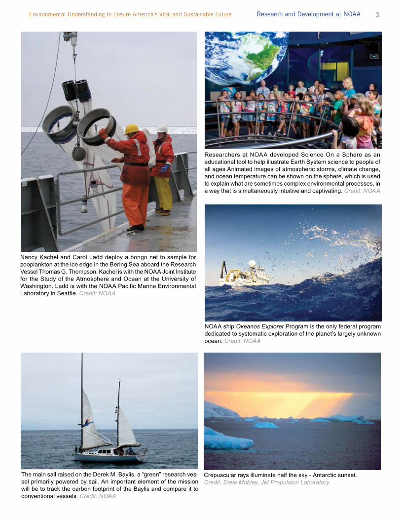
The main sail raised on the Derek M. Baylis, a “green” research ves-sel primarily powered by sail. An important element of the mission will be to track the carbon footprint of the Baylis and compare it to conventional vessels. Credit: NOAA
Researchers at NOAA developed Science On a Sphere as an educational tool to help illustrate Earth System science to people of all ages.Animated images of atmospheric storms, climate change, and ocean temperature can be shown on the sphere, which is used to explain what are sometimes complex environmental processes, in a way that is simultaneously intuitive and captivating. Credit: NOAA
NOAA ship Okeanos Explorer Program is the only federal program dedicated to systematic exploration of the planet’s largely unknown ocean. Credit: NOAA
Nancy Kachel and Carol Ladd deploy a bongo net to sample for zooplankton at the ice edge in the Bering Sea aboard the Research Vessel Thomas G. Thompson. Kachel is with the NOAA Joint Institute for the Study of the Atmosphere and Ocean at the University of Washington. Ladd is with the NOAA Pacific Marine Environmental Laboratory in Seattle. Credit: NOAA

4 Five Year Research and Development Plan 2013-2017
Executive summary RESEA
RCH
AND
DEVE
LOPM
ENT A
T NOAA......... ENVIRONMENTAL UNDERSTANDING TO EN
SURE AMERICA’S VITAL AND SUSTAINABLE FUTURE
5 Environmental Understanding to Ensure America’s Vital and Sustainable Future Research and Development at NOAA
NOAA’s R&D is inspired by both immediate and long-term needs and applications. it is focused on the Agency’s strategic goals
and reflects many contemporary scientific and technological challenges. R&D at NOAA is supported by a network of individuals, institutions, and infrastructure consisting of the Agency itself, as well as its broad suite of partners. the execution of NOAA R&D rests on a core set of values and rigorous system of strategic management.
Why R&D? NOAA is a mission agency, and R&D is an integral part of the Agency’s mission of science, service, and stewardship.4 R&D at the Agency seeks an understanding of global ecosystems5 to support informed decision-making. R&D leads to improved under-standing of the Earth system from global to local scales, improved ability to forecast weather, climate, and water resources, increased understanding of ecosystem health, and how all of these factors affect – and are affected by – people and communities. At NOAA, R&D is “use-inspired” – they not only increase our understanding of the world, but also produce applications that are useful and used.6 Maximizing “use-inspired” R&D depends upon the effective transfer of knowledge and tools into applications useful to society. NOAA continually seeks to increase the transition of information and technologies from R&D to applications.
Developing the NOAA 5 Year R&D Plan. the foundations of the plan are NOAA planning documents (e.g., Next Generation Strategic Plan, internal implementation Plans), specific strategic documents, such as the Arctic Action Plan, Science Challenge Workshop reports, and NOAA Science Advisory Board reports, such as the Portfolio Review task Force Report7. Based on these inputs, a writing team composed of representatives from cross-NOAA strategy teams (organized by the Agency’s strategic goals and enterprise objectives) defined a number of key questions facing society that can only be answered through research or development. Underneath each question were developed specific objectives and discrete, five-year targets for R&D that lay the path forward for NOAA and its R&D partners. NOAA actively solicited feedback from NOAA scientists and NOAA partners, such as Cooperative institutes, Sea Grant programs, Cooperative Science Centers, and others, as well as the external community of
4 NOAA’s Mission: to understand and predict changes in climate, weather, oceans, and coasts; to share that knowledge and information with others; and to conserve and manage coastal and marine ecosystems and resources.
5 At NOAA, an ecosystem is a geographically specified system of organisms (including humans), the environment, and the processes that control its dynamics.
6 Stokes, D. (1997). Pasteur’s quadrant : Basic science and technological inno-vation. Washington D.C.: Brookings institution Press.
7 NOAA’s Science Advisory Board has recently completed a review of the NOAA R&D portfolio. While this R&D plan has been greatly informed by the SAB’s findings and recommendations, particularly those focused on NOAA’s R&D, this plan does not constitute the formal response from NOAA to the SAB, nor does this plan attempt to address the recommendations on NOAA’s organi-zation and management.
stakeholders and collaborators. NOAA recognizes that only through the combined effort of the Agency and its partners can we conduct the breadth of R&D required to meet NOAA’s mission.
The Evolving Context for NOAA’s R&D. NOAA’s R&D enterprise will change as the needs of the Agency and the Nation evolve. the result of this evolution has largely been the convergence and integration of multiple disciplines. However, critical events and emergent phenomena have further refined NOAA’s R&D investments.
• Climate Change and Impacts from Greenhouse Gas Emissions- Since the last 5 Year R&D plan, the world has seen the on-going effects of increased greenhouse gases and global climate change, including significant changes to the Arctic ecosystem; sea level changes affecting our coastal communities; increased ocean temperatures threatening our coral reefs; and increasing ocean acidity challenging our coastal, marine, and Great lakes ecosystems.
• More Extreme Weather and Water Events-the Nation has
experienced a wave of severe weather events that demand improvements in NOAA’s forecast, communication and response abilities. 2011 was an unusually active and deadly year for tornadoes across the U.S. Additionally, Hurricane irene and Superstorm Sandy have highlighted NOAA’s unique ability to generate forecasts critical for decision makers, but also demonstrated areas where improvements can be made in the observations, models, forecasts and information delivery.
• Integrating Disciplines for a Systems Perspective-inte-grating different disciplines, including natural and social sciences, is essential to develop a more holistic under-standing of the Earth system. Nowhere is the need for integrated expertise more clear than in the implementation of the National Ocean Policy, which requires advancing our understanding of marine ecosystems.
• Preparing for and Responding to Unpredictable Events- While the results of R&D often take years to come to fruition, several recent events have demonstrated the need for, and the ability of, NOAA science to be responsive on more im-mediate time frames. Events such as the Deepwater Horizon oil spill and the 2011 tsunami and subsequent radioactive materials release have demonstrated that maintaining – and expanding – the diversity of NOAA’s expertise and experience makes the Nation and the world more resilient to high-impact events that have yet to occur.

6 Five Year Research and Development Plan 2013-2017
• Modeling and Managing Complex Systems- in many cases, what limits our ability to sustainably manage natural resources or respond to natural hazards is the complex and dynamic interconnectedness of large-scale physical and ecological systems. We can improve predictive capabilities by connecting and nesting models of physical systems, and by integrating biogeochemical with physical models, and biological with economic models. Ecosystems are also difficult to understand and even more difficult to simulate, but the potential value of making ecosystem predictions is enormous.
R&D at NOAA is directed toward the Agency’s outcome-oriented goals for Climate, Weather, Oceans, and Coasts, as well as its capability-oriented “enterprise” objectives. Focusing attention on outcomes rather than activities is the basis for making rational investment choices, aligning requirements, and clarifying roles and responsibilities. Goals and enterprise objectives are NOAA’s highest-level outcomes; the former are outcomes for society and environment, and the latter are outcomes for NOAA’s own capabilities in conducting its mission. the requirements for new knowledge and technology are defined by a series of key questions that respond to each goal or objective, as illustrated in the outline of NOAA’s R&D strategy presented below. the reader will notice the breadth of environmental and societal outcomes NOAA strives to achieve, as well as the broad scientific expertise needed to address the questions that follow. in the body of the plan, particular R&D objectives and targets show the steps toward addressing each question.
NOAA’S R&D STRATEgy
• Managing and Leveraging Big Data- NOAA must meet the challenge of managing large and complex data sets. increasingly, NOAA will need to meld its observation and model output data sets into validated, coherent, and easily usable “supersets” to better address complex environmen-tal problems. Big data also offers the opportunity to create innovative searching, sharing, analysis, and visualization capabilities.
7 Environmental Understanding to Ensure America’s Vital and Sustainable Future Research and Development at NOAA
NOAA center for weather and climate prediction, College Park, Maryland. Credit: University of Maryland
A WEATHER READy NATION
NOAA’s goal for A Weather Ready Nation is that society is prepared for and responds to weather related events. to achieve this goal, R&D will be directed to answer the following questions:
• How can we improve forecasts, warnings, and decision support for high-impact weather events?
• How does climate affect seasonal weather and extreme weather events?
• How can we improve space weather warnings?• How can we improve forecasts for freshwater
resource management?
cLIMATE ADAPTATION AND MITIgATION
NOAA’s goal for climate Adaptation and Mitigation is an informed society anticipating and responding to climate and its impacts. to achieve this goal, R&D will be directed to answer the following questions:
• What is the state of the climate system and how is it evolving?
• What causes climate variability and change on global to regional scales?
• What improvements in global and regional climate predictions are possible?
• How can NOAA best inform and support the Nation’s efforts to adapt to the impacts of climate variability and change?
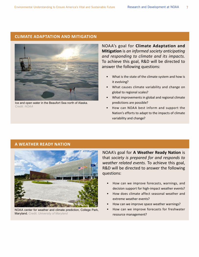
Ice and open water in the Beaufort Sea north of Alaska.Credit: NOAA

8 Five Year Research and Development Plan 2013-2017
Coral Reef, Florida Keys. Credit: NOAA
NOAA’s goal for Healthy Oceans is that marine fisheries, habitat, and biodiversity are sustained within healthy and productive ecosystems. to achieve this goal, R&D will be directed to answer the following questions:
• How do environmental changes affect marine ecosystems?
• What exists in the unexplored areas of our oceans? • How can emerging technologies improve ecosys-
tem-based management? • How can we ensure aquaculture is sustainable? • How is the chemistry of our ocean changing and
what are the effects?
HEALTHy OcEANS
Bleached brain coral. To determine the effects of bleaching events, NOAA assesses the extent of bleaching, recovery, and mortality of corals. Credit: NOAA
NOAA’s goal for Resilient coastal communities and Economies is that coastal and Great Lakes communities are environmentally and economically sustainable. to achieve this goal, R&D will be directed to answer the following questions:
• What is the value of coastal ecosystems? • How do coastal species respond to and relate to
habitat loss, degradation and change? • How do we ensure that growing maritime com-
merce stays safe and sustainable?• How do we reduce the economic, ecological, and
health impacts of degraded water quality?• How is the Arctic affected by expanding industry
and commerce?
RESILIENT cOASTAL cOMMuNITIES AND EcONOMIES

9 Environmental Understanding to Ensure America’s Vital and Sustainable Future Research and Development at NOAA
NOAA’s enterprise objective for Stakeholder Engagement is an engaged and educated public with an improved capacity to make scientifically informed environmental decisions. to achieve this objective, R&D will be directed to answer the following questions:
• How can we support informed public response to changing environmental conditions?
• How can we improve the way scientific information and its uncertainty are communicated?
NOAA ship Okeanos Explorer conducts operations in the northern Gulf of Mexico. Credit: NOAA
STAKEHOLDER ENgAgEMENT
NOAA’s enterprise objective for Environmental Data is accurate and reliable data from sustained and integrated Earth observing systems. to achieve this objective, R&D will be directed to answer the following questions:
• What is the best observing system to meet NOAA’s mission?
• How can we best use current and emerging environmental data?
• How can we improve the way we manage data?
Data collected by NOAA’s polar-orbiting operational environmental satellites are fed into sophisticated models that help National Weather Service forecasters “see” the early beginnings of heat waves. Credit: NOAA
ENVIRONMENTAL DATA

10 Five Year Research and Development Plan 2013-2017
People, Places and Things. NOAA R&D rests upon a foundation of indispensable assets. NOAA’s laboratories, science centers, grant programs and cooperative agreements support leading-edge research. NOAA’s progress depends on the coordinated functioning of this vibrant scientific enterprise, drawing on a broad range of skills and capabilities. NOAA R&D requires the experience and expertise of a top-notch workforce that extends beyond the Agency itself. the talent of the NOAA’s own bench scientists and engineers is comple-mented by extramural research partners who provide additional expertise (for example, the social science and science extension expertise at Sea Grant institutions) and additional technologies (for example, the satellite launch vehicles provided by NASA).
in addition to these “soft” assets (e.g., people, institutions, and partnerships) successful implementation of this plan involves “hard” assets (e.g., data, models, computers, ships, planes, satellites, buoys, laboratories). the increasing number of societal issues for which NOAA provides decision support requires improving and extending the range of our environmental analysis and modeling capabilities, both regionally and globally. Models and data assimilation systems provide essential forecasting and analysis tools for decision-making. these, in turn, rely on a base of integrated observations across many levels of space and time. increased understanding through improved analysis and modeling can lead to better weather, ecosystem, and climate forecasts, and ultimately to better decisions.
NOAA’s enterprise objective for Environmental Modeling is an integrated environmental modeling system. to achieve this objective, R&D will be directed to answer the following questions:
• How can modeling be best integrated and improved with respect to skill, efficiency, and adaptability?
• What information technology developments can help NOAA improve quantitative predictions?
IBM supercomputers used for climate and weather forecasts. Credit: NOAA
ENVIRONMENTAL MODELINg
What’s that? Interns serve as assistant naturalists during public collecting trips at the Woods Hole Science Aquarium (WHSA) summer programs for high school students in 2013. The programs are designed for students who are interested in marine science. Credit: WHSA/NOAA
NOAA’s strategic goals, and the key questions guiding R&D toward these goals, are the foci for integrating the work from NOAA programs, laboratories, and science centers, Cooperative institutes, grantees, contractors and other partners. Within this
framework of strategic goals and questions, the R&D objectives and targets are actively managed through a corporate system including regular planning, budgeting, monitoring, and evaluation activities.

11 Environmental Understanding to Ensure America’s Vital and Sustainable Future Research and Development at NOAA
A Healthy R&D Enterprise. A healthy R&D enterprise means that the Agency directs innovation that has direct impact on the NOAA mission and funds and executes those efforts though an organization with the appropriate capabilities and expertise of external partners. Enterprise health also requires building upon existing best practices to promote scientific and technological excellence and to enable scientists and science leaders to pursue varied and valued R&D. NOAA is committed to ensuring its research is of demonstrable excellence, is responsive to societal needs, and provides the basis for new and more effective operational services and management actions. to achieve this, NOAA’s R&D enterprise rests on the following fundamental principles.
Integrity. For science to be useful, it must be credible. NOAA’s research must be conducted with the utmost integrity and transparency. the recently established NOAA Administrative Order on Scientific integrity establishes a code of conduct for scientists and science managers that allows us to operate as trusted source for environmental science.
collaboration. NOAA requires the unique capabilities and ex-pertise of its partners. the R&D required by NOAA’s mission cannot be conducted by the Agency alone. Extramural and cooperative research provides both increased flexibility and a diversity of expertise and capabilities that the Agency does not maintain. NOAA’s partners contribute to meeting the Agency’s goals and objectives, as well as promote the wider use of our joint research results.
Integration. A holistic understanding of the Earth system comes from both understanding its individual components, as well as understanding and interpreting the way all of the components fit together, interrelate, and interact. NOAA is committed to providing both the discipline-specific foundation and the multi-disciplinary integration required to achieve and use a holistic understanding of the Earth system.
Innovation. innovation is the implementation of a new or significantly improved product, process, business practice, workplace organization, or relationship.8 ideas and inventions are necessary for innovation; however, alone, they are not suf-ficient.9 innovation is the process of using ideas and inventions to create value.10 NOAA is committed to supporting innovation throughout its R&D enterprise to improve the understanding, products and services that support the Nation.
Balance. NOAA is committed to addressing the immediate needs of the Nation and the emerging challenges for the future. there-fore, NOAA must balance its portfolio of activities to achieve both long-term and short-term outcomes across its strategic goals and enterprise objectives. NOAA also strives for balance
8 Organisation for Economic Co-operation and Development. (2005) Oslo manual: Guidelines for collecting and interpreting innovation data. Paris: Organisation for Economic Co-operation and Development.
9 Freeman, C., and Soete, l. (1997). The economics of industrial innovation. Cambridge, MA: Mit Press.
10 US Council on Competitiveness. (2005) Innovate America: National innovation initiative summit and report. Washington DC: US Council on Competitiveness.
EMILY (an acronym for Emergency Integrated Life Saving Lanyard), a 65-inch water-tight craft, is one of NOAA’s hurricane research platforms. Outfitted with a satellite link, camera, battery and gasoline motor, and a variety of sensors, EMILY will collect sea-level data from within a hurricane. Credit: Hydronalix Inc.
12 Five Year Research and Development Plan 2013-2017
between innovations that are required (“pulled”) by stakehold-ers versus those that are discovered or developed (“pushed”) by researchers, those that are low-risk versus high risk, and those that will yield incremental versus radical change.
A healthy R&D enterprise requires effective R&D management. this includes actively planning, monitoring, evaluating, and reporting on the Agency’s R&D to ensure the Nation receives a sustained return on its investment. For R&D, as with all other aspects of NOAA’s mission, performance management is conducted by all NOAA line offices through an iterative corporate process of Strategy Execution and Evaluation (SEE). Strategy-based performance management is an iterative process of implementation planning, budgeting, exe-cution, evaluation, and the application of evaluation to subsequent planning, budgeting, and execution. Greater detail on this can be found in NOAA’s Administrative Order on Strengthening the R&D Enterprise.
A well-functioning innovation system also requires coordination across its components, a vibrant exchange of scientific and man-agement viewpoints, and a clear understanding of the mission, goals and objectives —not only by NOAA but partner organizations as well. A strong scientific enterprise, like any resilient system, is determined not only by the quality of its components, but also in how well connected they are. As social and economic systems evolve and become more complex, the tools and information needed to promote growth, to preserve and improve human and environmen-tal health, to develop and maintain a viable national infrastructure, and to provide security for present and future generations must advance as well.11
11 National Oceanic and Atmospheric Administration. Research in NOAA: toward Understanding and Predicting Earth’s Environment. January 2008.
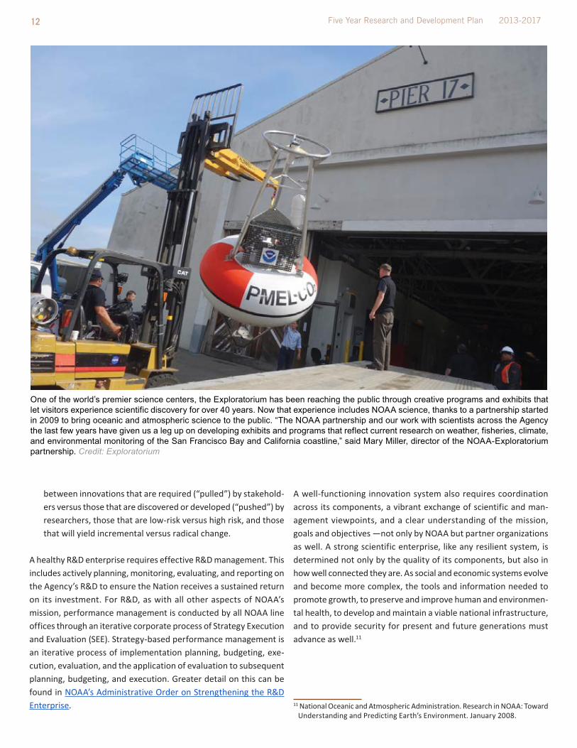
One of the world’s premier science centers, the Exploratorium has been reaching the public through creative programs and exhibits that let visitors experience scientific discovery for over 40 years. Now that experience includes NOAA science, thanks to a partnership started in 2009 to bring oceanic and atmospheric science to the public. “The NOAA partnership and our work with scientists across the Agency the last few years have given us a leg up on developing exhibits and programs that reflect current research on weather, fisheries, climate, and environmental monitoring of the San Francisco Bay and California coastline,” said Mary Miller, director of the NOAA-Exploratorium partnership. Credit: Exploratorium
13 Environmental Understanding to Ensure America’s Vital and Sustainable Future Research and Development at NOAA
for research. Knowledge and inventions are applied and create value for NOAA and our partners through transition activities, through which we find out what questions are most important for research to answer and what requirements our partners have for new or improved technologies.
When used, the scientific knowledge and technological capabilities that NOAA R&D produce yield benefits in different and comple-mentary ways:
• improved operations for NOAA’s mission • Direct protection of lives and property• Economic growth through innovation• Satisfaction of legal mandates
Each of these is addressed in the sections that follow.
SEcTION 1. WHy R&D?
NOAA traces its lineage back to America’s oldest science agency, and our reach extends from the surface of the sun to the bottom of the sea. We study, monitor, and predict changes in Earth’s environment, and provide critical environmental information to the nation. We are stewards of our nation’s fisheries, coasts and oceans. Our work makes a difference in the lives of all Americans. Every day:
• Businesses large and small depend on NOAA’s weather forecasts to make important decisions;
• Fishermen and ship captains go to sea with the benefit of NOAA’s charts and forecasts;
• Our nation’s ports, through which 90% of the nation’s imports and exports travel, are safer thanks to NOAA information and services;
• Americans enjoy fresh seafood caught or grown sustainably in our waters;
• Coastal tourism thrives in part because of NOAA’s work to protect healthy marine ecosystems that support recreation-al fishing and boating, bird and whale watching, snorkeling on coral reefs and spending time at the beach; and
• Military leaders, emergency managers, farmers, airline pilots, and many others depend on NOAA for vital information about weather and weather-related disasters.
R&D at NOAA improves our collective understanding of Earth as a system, improves our ability to forecast weather, climate, and water resources, increase our understanding of ecosystem health, and how these factors affect – and are affected by – people and communities. it is the utility of the Agency’s science and technology in light of national concerns that makes NOAA so unique. NOAA conducts R&D to create value for the public through new insights and applications.
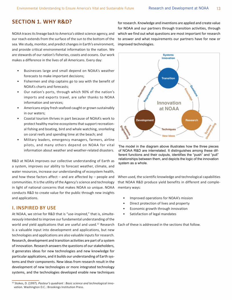
I. INSPIRED By uSEAt NOAA, we strive for R&D that is “use-inspired,” that is, simulta-neously intended to improve our fundamental understanding of the world and yield applications that are useful and used.12 Research is a valuable input into development and applications, but new technologies and applications are also valuable inputs for research. Research, development and transition activities are part of a system of innovation. Research answers the questions of our stakeholders, it generates ideas for new technologies and new knowledge for particular applications, and it builds our understanding of Earth sys-tems and their components. New ideas from research result in the development of new technologies or more integrated technology systems, and the technologies developed enable new techniques
12 Stokes, D. (1997). Pasteur’s quadrant : Basic science and technological inno-vation. Washington D.C.: Brookings institution Press.
The model in the diagram above illustrates how the three pieces of NOAA R&D are interrelated. It distinguishes among these dif-ferent functions and their outputs, identifies the “push” and “pull” relationships between them, and depicts the logic of the innovation system as a whole.

14 Five Year Research and Development Plan 2013-2017
A. improving NOAA Science, Service and Stewardship
As outlined in NOAA’s Next Generation Strategic Plan, NOAA pro-vides “research-to-application capabilities that can recognize and apply significant new understanding to questions, develop research products and methods, and apply emerging science and technology to user needs.”13 these capabilities are brought to bear on the four strategic goals directing NOAA’s mission:
• Climate Adaptation and Mitigation – An informed society anticipating and responding to climate and its impacts
• Weather Ready Nation – Society is prepared for and responds to weather-related events
• Healthy Oceans – Marine fisheries, habitats, and biodiversity are sustained within healthy and productive ecosystems
• Resilient Coastal Communities and Economies – Coastal and Great lakes communities are environmentally and economically sustainable
Unified by an overarching vision of resilient ecosystems, commu-nities, and economies, these goals are mutually supportive. For example, just as economic prosperity depends upon a healthy environment, the sustainability of ocean and coastal ecosystems depends on society’s ability to mitigate and adapt to changing climate. Similarly, sustainable economic growth along the coasts and in arid regions around the world depends upon climate pre-
13 National Oceanic and Atmospheric Administration. Next Generation Strategic Plan. December 2010.
dictions and projections to inform community development and agriculture. likewise, the resilience of communities depends on their understanding of, and preparedness for, high-impact weather and water conditions.
While NOAA’s four goals are complementary, achieving each presents unique challenges for R&D. Addressing the needs of the individual goals requires examining the common science and tech-nology elements that support all of the goals, such as observations, modeling, and computer technologies. NOAA also seeks to improve how its R&D is used by its stakeholders, incorporating assessments of how our science is used by society.
Ultimately, the strength of NOAA’s R&D rests in the integration of the mission goals. A continuing challenge is to bring together individual components into an integrated and holistic Earth system understanding that then can be broadly applied. With a holistic Earth system perspective, NOAA can address not only the key questions that fall into a particular goal or objective, but also those questions that are broader than a single goal.
B. Protecting lives and PropertyEarth’s ecosystems support people, communities, and economies; human health, prosperity, and well-being depend on the health and resilience of the natural environment. these interconnections also present challenges. High impact weather events, freshwater avail-ability, coastal urbanization, ocean and coastal resource use, and climate change are among the central challenges NOAA addresses in the interest of public welfare. these are some of the challenges that we are experiencing or can foresee, but there are many that
NOAA’s Mission: Science, Service, and Stewardshipto understand and predict changes in climate, weather,
oceans, and coasts, to share that knowledge and information with others, and to conserve and manage coastal and marine
ecosystems and resources.
Definitions of Research, Development, and TransitionResearch: systematic study directed toward fuller scientific knowledge or understanding of the subject studied.
Development: systematic use of the knowledge or understanding gained from research, directed toward the production of useful materials, devices, and systems or methods, including design, de-velopment, and improvement of prototypes and new processes. it excludes quality control, routine product testing, and production.
Transition is the transfer of knowledge or technology from a research or development setting to an operational setting. transition occurs in two phases: Demonstration (e.g., the use of test-beds to confirm operational usability or demonstration using rapid prototyping) is part of R&D, while deployment (e.g., the integration of new people and equipment into an operational environment) is part of operations. transition may occur from NOAA-conducted R&D to NOAA operations, from NOAA-con-ducted R&D to an external partner’s application, or from external partner-conducted R&D to NOAA operations.
A sea turtle swims near oiled Sargassum algae. Credit: Carolyn Cole/LA Times
15 Environmental Understanding to Ensure America’s Vital and Sustainable Future Research and Development at NOAA
we cannot, especially in a rapidly changing world.
Sudden events often challenge us. Superstorm Sandy demonstrated the significant vulnerability of the nation’s coastal areas to storms and inundation. the same is true of the Deepwater Horizon explo-sion and subsequent protracted oil spill, the earthquake and tsunami that triggered a nuclear meltdown in Fukushima, the eruptions of Eyjafjallajökull that caused global aviation disruptions – each of these events challenged us but also demonstrated our tremendous capability to anticipate, respond, and adapt. they also underscored the need to further improve our capability to understand and predict Earth systems and to build resilience. NOAA R&D will continue to be central to creating solutions to the known and unknown challenges before us.
As social and economic systems evolve and become more complex, the tools and information needed to promote growth, to preserve and improve human and environmental health, to develop and maintain a viable national infrastructure, and to provide security for present and future generations must advance as well.14 the demands for responsive and forward-thinking science, service, and stewardship are reflected in our daily lives:
• A nationwide survey indicates that 96% of the U.S. public obtains, either actively or passively, a total of 301 billion weather forecasts each year. Based on the average annual household value placed on weather information of $286, the American public collectively receives $31.5 billion in benefits from weather forecasts each year.15
14 National Oceanic and Atmospheric Administration. Research in NOAA: toward Understanding and Predicting Earth’s Environment. January 2008.
15 lazo, J.K., R.E. Morss, and J.l. Demuth. (2009): 300 Billion served: Sources, perceptions, uses, and values of weather forecasts. Bulletin of the American Meteorological Society, 90: 785-798.
• there are increasing demands on the nation’s ocean and coastal resources that provide important products and ser-vices. Seafood, tourism, recreation, protection from coastal storms are the source of billions of dollars in economic activity and millions of jobs. For example, in 2009, the U.S. seafood and recreational fishing industry alone supported approximately 1.3 million jobs and generated $166 billion in sales impacts and $32 billion in income impacts (NMFS 2010).16
• Since 2000, the total United States land area affected by drought of at least moderate intensity has varied from as little as 7% of the contiguous United States (August 3, 2010) to as much as 46% of the U.S. land area (September 10, 2012).17
“It is through research that society gains the understanding to make informed decisions in this increasingly complex world.”18
Over the next five years, NOAA R&D activities will address those societal challenges and trends that are of great importance to decision makers. there are increasing demands for services to help people make the best possible decisions in light of issues such as National and global population growth, migration towards coastal regions, impacts of climate change, changing water supply and water quality.19
C. Growing the EconomyNOAA science and technology impact our personal lives and the global economy. For example, the quality of weather forecasts
16 Fisheries Economics of the United States, 2010 (forthcoming, not yet pub-lished)
17 NOAA testimony, COMMittEE ON SCiENCE, SPACE, AND tECHNOlOGY, U.S. HOUSE OF REPRESENtAtiVES, July 25, 2012
18 National Oceanic and Atmospheric Administration. Research in NOAA: toward Understanding and Predicting Earth’s Environment. January 2008.
19 National Oceanic and Atmospheric Administration. Research in NOAA: toward Understanding and Predicting Earth’s Environment. January 2008.
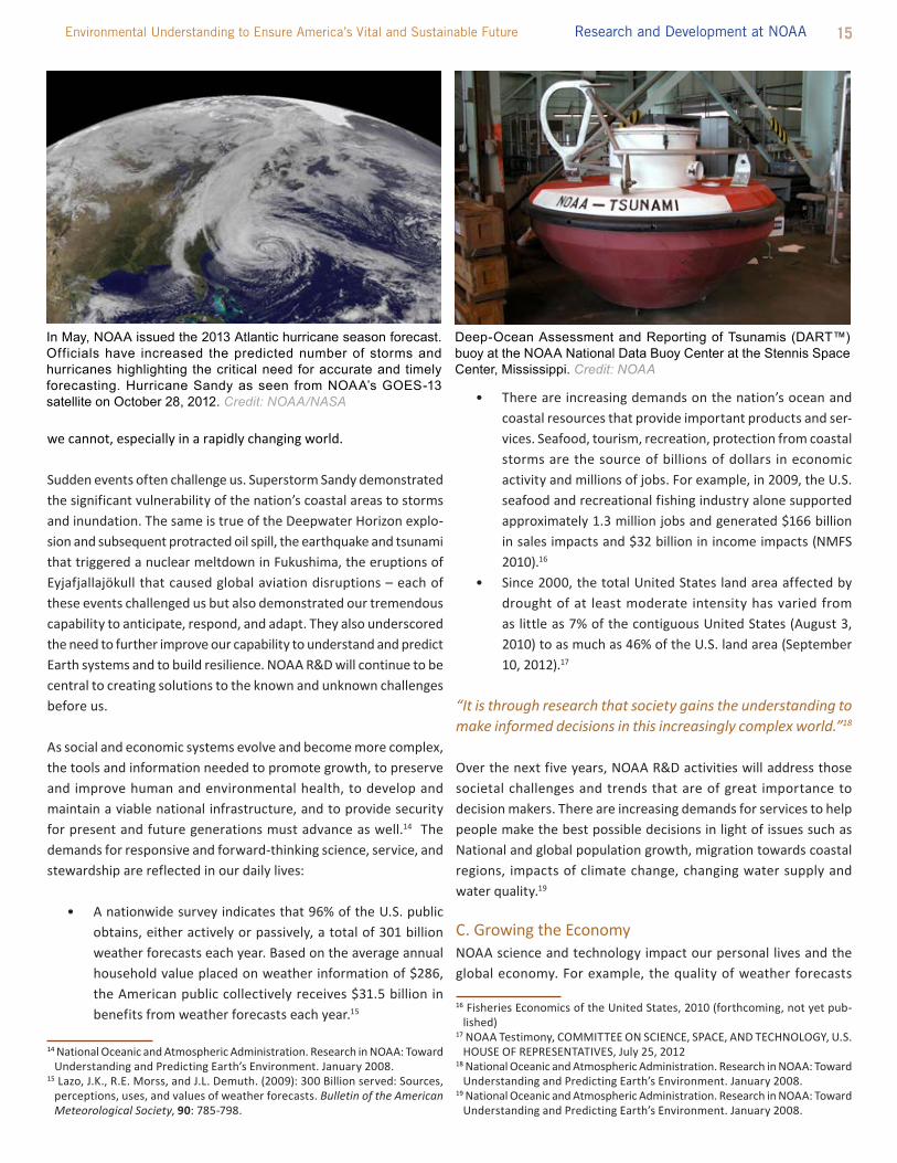
Deep-Ocean Assessment and Reporting of Tsunamis (DART™) buoy at the NOAA National Data Buoy Center at the Stennis Space Center, Mississippi. Credit: NOAA
In May, NOAA issued the 2013 Atlantic hurricane season forecast. Officials have increased the predicted number of storms and hurricanes highlighting the critical need for accurate and timely forecasting. Hurricane Sandy as seen from NOAA’s GOES-13 satellite on October 28, 2012. Credit: NOAA/NASA

16 Five Year Research and Development Plan 2013-2017
to compete with larger businesses. SBiR funds the critical startup and development stages and it encourages the commercialization of the developed technology, product, or service, which, in turn, stimulates the U.S. economy.
D. legislative Drivers for NOAA R&DAs an agency of the Executive Branch of the United States govern-ment, NOAA complies with federal statutes and Executive orders. R&D is explicitly mandated by some of these drivers; for others, R&D provides the scientific and technical foundation to effectively execute them. these drivers are diverse: ranging from the Ocean Exploration Program Act, which focuses on unexplored regions of the deep oceans that encompass 95% of the ocean; to the Weather Service Organic act, which provides NOAA with the authority to forecast, record, report, monitor, and distribute meteorological, hydrologic and climate data; to the Magnuson-Stevens Fishery Conservation and Management Act, which requires rebuilding and maintaining the Nation’s fishery stocks.21 Each of these mandates focuses on a specific need, topic, or challenge for the Nation; how-ever, the strength of the NOAA R&D enterprise rests on not only
21 A full list of mandates and additional drivers is provided in Appendix A.
depends on R&D. According to a 2005 study, U.S. electricity pro-ducers annually save $166 million by using 24-hour temperature forecasts to improve the mix of generating units that are available to meet electricity demand. 20 these savings could be increased even further if forecast accuracy were increased, lead time were extended, uncertainty were reduced, or communication to the public were improved.
to ensure that the United States benefits from and fully exploits its scientific research and technology, NOAA encourages its productive use of intellectual property through the patent process. NOAA can transfer its intellectual property through patent licenses and Cooperative R&D Agreements (CRADAs). these efforts allow U.S. companies to make strategic use of public investments in R&D, with the goal of providing them an overall competitive advantage.
NOAA also reserves a specific percentage of federal extramural R&D funds for small business through the Small Business innovation Research, or SBiR, program. the SBiR program provides valuable funds and support for innovative small businesses and enables them
20 teisberg, t., Weiher, R., and A. Khotanzad. (2005). the Economic Value of temperature Forecasts in Electricity Generation. Bulletin of the American Meteorological Society, 86: 1765 – 1771.
SBIR Success Story
Desert Star Systems, llC, manufactures electronic satellite tags and other underwater sensory systems for tracking sub-surface devices/animals. Desert Star has been successfully working with the SBiR program since 1995. During this time, the additional sales revenue generated through Phase 3 commercialization projects has resulted in approximately $6.2 million, or just above half of Desert Star’s average sales revenue.
Desert Star recently developed the first stored solar power line of electronic animal tags, called Sea tag, used to capture simultaneous migration and oceanographic data. Seatag expands on current tagging technologies by offering a different array of sensors and capabilities. All Seatag devices are powered through the use of stored solar power with the exception of -CAM and -RC which also use batteries. the tag is equipped with a solar cell and a capacitor which powers the tag for approximately two weeks of total darkness on tens of minutes of sunlight. (http://www.desertstar.com/Products_category.aspx?intProductCategoryiD=)
According to company representatives, this new product line is expected to double or triple annual revenues within the next 2-4 years.
Technology Transfer Success Story
Over the last 20 years, the Physical Science Division of the Earth System Research lab (ESRl) in Boulder, CO, has teamed with three industrial partners in Cooperative R&D Agreements, or CRADAs, to design, develop, and commercialize a wind profiler technology in the United States. the wind profilers measure wind direction, speed, and air turbulence through phased-array radar systems and are very useful in determining the best locations for land-based wind turbines, improved weather forecasting, and air quality forecasts.
throughout the developmental lifetime of this suite of profilers, NOAA technical staff provided critical expertise for the electronic signal processing in data acquisition and interpretation. industry partners provided real-time customer requirements to NOAA engineers such that design improvements could be incorporated seamlessly in the manufacturing process. the creation of both an engineering and management oversight boards played an important role by allocating new resources at important project moments as technical and market conditions changed.
this successful collaboration and technology transfer from the federal lab to industry has resulted in over $2 million in royalties, as well as an estimated $25 million in global sales of the product.

17 Environmental Understanding to Ensure America’s Vital and Sustainable Future Research and Development at NOAA
fulfilling those requirements but examining the areas of synergy and integrating the required research into a holistic perspective.
II. BEyOND OcEANS AND ATMOSPHEREBecause NOAA’s R&D is intended to be used, the Agency must go beyond the physical, chemical, and biological science disciplines to include social sciences. NOAA seeks to maximize the user benefits of its R&D investments by:
• Understanding and responding to the needs of our stake-holders;
• Articulating the inherent uncertainty associated with research;
• Defining and quantifying the value of its R&D; and • improving investments into knowledge and services that
can be used by decision makers.
A. informing Decisions locally and GloballyNOAA’s vision for the future – healthy ecosystems, communities and economies that are resilient in the face of change – has no geographic boundary. A coastal community seeking to mitigate impacts of rising sea level can use predictions derived from global climate models. improved understanding of the impacts of coastal development is informing local managers and communities of risks to human health and the ecosystem. long-term investments in climate science have dramatically improved our understanding of the variability in the climate system; investments in research, mon-itoring, and modeling now allow us to predict the El Niño-Southern Oscillation (ENSO). ENSO affects temperatures, water resources, living resources, and storm activity. Understanding its trends and impacts allow for advance warning and preparation. to assess post-earthquake/tsunami radiation dispersion from Fukushima around the world, NOAA used models to understand how, where, and when chemical species and other materials are transported through the air and water. NOAA will continue to respond to critical questions and challenges on local to global scales, how they impact people and communities, now and in the future.
B. Understanding Human BehaviorSustaining coastal and marine ecosystem services is widely recog-nized as one of the most important environmental challenges of the 21st century. Given that the principal threat to these ecosystems is derived from manmade sources, strategies for preserving or recovering a coastal or marine ecosystem should consider human use patterns and values. incorporating economics, social and behavioral sciences into emerging integrated ecosystem models and assessments can provide policy makers with an understanding of both the value of ecosystem services as well as the trade-offs associated with alternative management scenarios.
incorporating the “human dimension” into NOAA’s research mission also allows for improved design and delivery of NOAA’s products and services, by increasing our understanding of what information is relevant, and identifying how people receive and use the informa-tion provided. Using social sciences also enables NOAA to evaluate how and to whom the benefits of its services accrue. this includes understanding who constituents are, how they use information to make decisions, how these decisions map into changes in health and wealth, and how they interpret and respond to regulations which can help target future improvements to, for example, forecasts of hurricanes, heat waves, and Harmful Algal Blooms (HABs). to truly realize the benefits of this investment in forecast improvements, society must understand and respond appropriately to the informa-tion provided. NOAA seeks to enhance and expand the integration of social sciences with NOAA’s natural sciences to fully understand the services ecosystems provide to society and how people value them; determine how to best engage the public; to help define more specific social and cultural objectives for communities; increase the social and economic returns of NOAA’s research investment; and provide guidance for tailoring technology development and implementation for its most effective use.
to effectively carry out its mission, NOAA requires the research necessary to design and deliver services that match the needs of constituents. Sound and relevant corporate social science will allow NOAA to consistently articulate the value its products and services deliver to the nation and help ensure that NOAA’s resources are allocated optimally across programs and objectives.
C. Communicating UncertaintyUncertainties affect almost all aspects of NOAA’s work, including satellite measurements, assessments of past climate trends, and fish stock surveys. the National Research Council (NRC) defines uncertainty22 as “the condition whereby the state of a system cannot be known unambiguously. Probability is one way of expressing uncertainty.” Describing uncertainty in the context of environmental science and prediction, the NRC states that, “the chaotic character of the atmosphere, coupled with inevitable inadequacies in observa-tions and computer models, results in forecasts that always contain uncertainties. these uncertainties generally increase with forecast lead time and vary with weather situation and location. Uncertainty is thus a fundamental characteristic of weather, seasonal climate, and hydrological prediction, and no forecast is complete without a description of its uncertainty.”
Decision makers and the public require that NOAA provide informa-tion on the uncertainty in its prediction and projection products to
22 National Academies of Science. Completing the Forecast: Characterizing and Communicating Uncertainty for Better Decisions Using Weather and Climate Forecasts. National Academies Press, Washington, DC. 2006.

18 Five Year Research and Development Plan 2013-2017
assess the significance and utility of the information and to weigh the information with respect to decisions. Consequently, NOAA requires research, development, and implementation of methods and capabilities for quantifying and communicating uncertainty. Research is required to understand, for situations and applications, the amount of uncertainty; factors contributing to uncertainty; how to minimize the uncertainty; and how best to communicate that uncertainty. Public understanding of the uncertainty for NOAA’s products and services will help the public and decision makers make the best choices.
D. transferring Knowledge and technology R&D at NOAA is outcome-oriented, focusing on the ultimate use of its investment, such as improved community resiliency in the face of climate change. Achieving outcomes depends upon the effective transfer of knowledge and tools into applications useful to society, including new or improved capabilities in NOAA’s operational ser-vices. Effective transfer, or “transition,” as it is called within NOAA, requires planning and collaborative efforts between research and applications teams.
NOAA continually seeks to increase the transition of information and technologies from R&D to applications. this involves design and stakeholder engagement in addition to science and engineering. transition occurs in two phases: demonstration (e.g., the use of test-beds or rapid prototyping to prove that a technology works) and deployment (e.g., the integration of new people, equipment, or techniques into an operational environment). Demonstration is a part of R&D; deployment is part of operations; both are required for transition to occur. transition may occur from NOAA-conducted R&D to NOAA application, NOAA-conducted R&D to an external partner’s application, or external partner-conducted R&D to NOAA applications.
For example, the development and transition of the Harmful Algal Bloom Operational Forecast System, which provides information
on the location, extent, and the potential for development or movement of HABs in the Gulf of Mexico, required the focused effort of researchers, modelers, and operations personnel from NOAA and its partners to bring the project to fruition. Dedicated resources, including test beds and proving grounds, increase collaborations between those who perform research, and those who perform operations, and build support for continual infusion of R&D results into applications at NOAA and beyond.
in addition to technology transition, NOAA R&D yields the improved understanding necessary to support business and policy decisions through publications, consultations, and training on specific tools. For example, Regional integrated Sciences and Assessments (RiSA) support integrated, place-based research across a range of social, natural, and physical science disciplines to help decision makers understand their options in the face of climate change and variability at the regional level.
III. DEVELOPINg THE FIVE yEAR R&D PLANthe NOAA 5-Year R&D Plan for 2013-2017 has been developed as a cross line Office initiative led by the NOAA Research Council. this plan is the third Research Plan produced by NOAA and the first to explicitly include “development” as part of the research enterprise. the foundations of the plan are NOAA planning documents (e.g., Next Generation Strategic Plan, SEE implementation Plans), spe-cific strategic documents, such as the Arctic Action Plan, Science Challenge Workshop reports, and NOAA Science Advisory Board reports, such as the Portfolio Review task Force Report. While this R&D plan has been greatly informed by the SAB’s findings and recommendations, particularly those focused on NOAA’s R&D, this plan does not constitute the formal response from NOAA to the SAB, nor does this plan attempt to address the recommendations on NOAA’s organization and management. Based on these inputs, a writing team composed of representatives from cross-NOAA strate-gy teams (organized by the Agency’s strategic goals and enterprise objectives) defined a number key questions facing society that can only be answered through research or development. Underneath each question were developed specific objectives and discrete, five-year targets for R&D that lay the path forward for NOAA and its R&D partners. Additionally, input from NOAA leadership, scientists and NOAA external stakeholders has helped guide the content of the plan. in particular, NOAA actively solicited feedback from its partners, such as its Cooperative institutes, Sea Grants, Cooperative Science Centers, and others, as well as the external community of stakeholders and collaborators. NOAA recognizes that only through the combined effort of the Agency and its partners can we achieve the breadth of R&D required to meet NOAA’s mission.
Satellite image of 2011 bloom (the most severe in decades). Credit: MERIS/NASA; processed by NOAA/NOS/NCCOS
19 Environmental Understanding to Ensure America’s Vital and Sustainable Future Research and Development at NOAA
SEcTION 2. NOAA’S STRATEgIc APPROAcH TO R&D
I. 20 yEAR RESEARcH VISION AND ScIENcE gRAND cHALLENgESto fulfill the promise of a science agency that delivers critical and necessary information and services to the public in the short- and long-term, NOAA developed a 20-year vision for research in 2005. this vision, “Understanding global ecosystems to support informed decision-making,”23 has guided NOAA’s investment in research and provides a perspective that addresses the immediate and future needs of the Nation. this vision drives the continued planning, investment, and implementation of NOAA’s R&D enterprise.
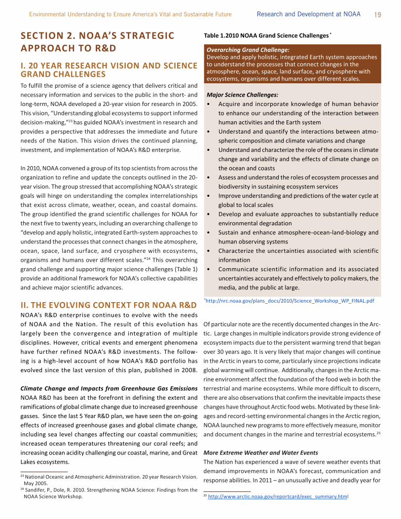
in 2010, NOAA convened a group of its top scientists from across the organization to refine and update the concepts outlined in the 20-year vision. the group stressed that accomplishing NOAA’s strategic goals will hinge on understanding the complex interrelationships that exist across climate, weather, ocean, and coastal domains. the group identified the grand scientific challenges for NOAA for the next five to twenty years, including an overarching challenge to “develop and apply holistic, integrated Earth-system approaches to understand the processes that connect changes in the atmosphere, ocean, space, land surface, and cryosphere with ecosystems, organisms and humans over different scales.”24 this overarching grand challenge and supporting major science challenges (table 1) provide an additional framework for NOAA’s collective capabilities and achieve major scientific advances.
II. THE EVOLVINg cONTExT FOR NOAA R&DNOAA’s R&D enterprise continues to evolve with the needs of NOAA and the Nation. the result of this evolution has largely been the convergence and integration of multiple disciplines. However, critical events and emergent phenomena have further refined NOAA’s R&D investments. the follow-ing is a high-level account of how NOAA’s R&D portfolio has evolved since the last version of this plan, published in 2008. Climate Change and Impacts from Greenhouse Gas Emissions NOAA R&D has been at the forefront in defining the extent and ramifications of global climate change due to increased greenhouse gasses. Since the last 5 Year R&D plan, we have seen the on-going effects of increased greenhouse gases and global climate change, including sea level changes affecting our coastal communities; increased ocean temperatures threatening our coral reefs; and increasing ocean acidity challenging our coastal, marine, and Great lakes ecosystems.
23 National Oceanic and Atmospheric Administration. 20 year Research Vision. May 2005.
24 Sandifer, P., Dole, R. 2010. Strengthening NOAA Science: Findings from the NOAA Science Workshop.
Of particular note are the recently documented changes in the Arc-tic. large changes in multiple indicators provide strong evidence of ecosystem impacts due to the persistent warming trend that began over 30 years ago. it is very likely that major changes will continue in the Arctic in years to come, particularly since projections indicate global warming will continue. Additionally, changes in the Arctic ma-rine environment affect the foundation of the food web in both the terrestrial and marine ecosystems. While more difficult to discern, there are also observations that confirm the inevitable impacts these changes have throughout Arctic food webs. Motivated by these link-ages and record-setting environmental changes in the Arctic region, NOAA launched new programs to more effectively measure, monitor and document changes in the marine and terrestrial ecosystems.25 More Extreme Weather and Water Eventsthe Nation has experienced a wave of severe weather events that demand improvements in NOAA’s forecast, communication and response abilities. in 2011 – an unusually active and deadly year for
25 http://www.arctic.noaa.gov/reportcard/exec_summary.html
Overarching Grand Challenge: Develop and apply holistic, integrated Earth system approaches to understand the processes that connect changes in the atmosphere, ocean, space, land surface, and cryosphere with ecosystems, organisms and humans over different scales.
Major Science Challenges:• Acquire and incorporate knowledge of human behavior
to enhance our understanding of the interaction between human activities and the Earth system
• Understand and quantify the interactions between atmo-spheric composition and climate variations and change
• Understand and characterize the role of the oceans in climate change and variability and the effects of climate change on the ocean and coasts
• Assess and understand the roles of ecosystem processes and biodiversity in sustaining ecosystem services
• improve understanding and predictions of the water cycle at global to local scales
• Develop and evaluate approaches to substantially reduce environmental degradation
• Sustain and enhance atmosphere-ocean-land-biology and human observing systems
• Characterize the uncertainties associated with scientific information
• Communicate scientific information and its associated uncertainties accurately and effectively to policy makers, the media, and the public at large.
Table 1.2010 NOAA grand Science challenges *
*http://nrc.noaa.gov/plans_docs/2010/Science_Workshop_WP_FiNAl.pdf

20 Five Year Research and Development Plan 2013-2017
tornadoes across the U.S. – there were 1,691 tornadoes reported across the country, more than any other year on record except for 2004, which saw 1,817 tornadoes. these include the tornado that hit the city of Joplin, Missouri on May 22, 2011, leaving an estimated 157 people dead. the Joplin tornado is the deadliest single tornado since modern record keeping began in 1950 and is ranked as the 7th deadliest in U.S. history.26
Hurricane irene and Superstorm Sandy are some of the more recent examples of devastating storms that have challenged the Nation. these storms highlighted NOAA’s unique ability to generate forecasts critical for decision makers, but also demonstrated areas where improvements can be made in the observations, models, forecasts and delivery of information. these storms, particularly Superstorm Sandy, demonstrated the significant vulnerability of the nation’s coastal areas to coastal storms and flooding, especially as sea levels continue to rise.
in addition to severe weather, water resources present a chal-lenge for the Nation. According to the U.S. Drought Monitor (USDM), as of early December 2012, more than 60% of the country (by geographic area) experienced drought conditions (moderate to exceptional).27 A partnership of federal agen-cies, led by NOAA, has begun implementation of the National integrated Drought information System (NiDiS) to provide decision support for drought planning. the demand for drought understanding and prediction will likely only increase. Integrating Disciplines for a Systems Perspectiveintegrating different disciplines, including natural and social sci-ences, is essential to develop a more holistic understanding of the Earth system. NOAA’s expertise has traditionally been in the natural sciences of the ocean and the atmosphere, but more and more, mission success depends on a holistic understanding of how natural phenomena are intertwined with human behavior and institutions. Nowhere is the need for integrated expertise more clear than in the implementation of the National Ocean Policy, which “establishes a comprehensive national approach to uphold our stewardship responsibilities; ensures accountability for our actions; and serves as a model of balanced, productive, efficient, sustainable, and informed ocean, coastal, and Great lakes use, management, and conservation within the global community.”28
implementing the National Ocean Policy requires advancing our understanding of marine ecosystems. As noted in the National Ocean Policy implementation Plan, current understanding of marine ecosystems has not kept pace with the cumulative impacts of human uses and the environmental changes that are occurring.
26 http://www.noaanews.noaa.gov/2011_tornado_information.html27 http://droughtmonitor.unl.edu/archive.html28 http://www.whitehouse.gov/files/documents/OPtF_FinalRecs.pdf
to implement ecosystem-based management successfully (an inte-grated approach to resource management that considers the entire ecosystem, including humans), decisions must be informed by the best available ecological, social, and economic science and data.29
Preparing for and Responding to Unpredictable EventsSome of the research that NOAA conducts is unexpected and in re-sponse to immediate needs for public safety and security. While the results of R&D often take years to come to fruition, several recent events have demonstrated the need for, and the ability of, NOAA science to be responsive on more immediate time frames. in 2010, the Deepwater Horizon oil rig exploded in the Gulf of Mexico, killing 11 people and instigating the largest marine oil spill in U.S. history. this “omnidirectional, almost indeterminate threat” challenged the resources and capabilities of the federal, state, and local authorities responding to this threat.30 in 2011, an earthquake caused a tsunami that devastated the northeastern coast of Japan. in addition to the loss of life and property, the tsunami triggered a series of failures at the Fukushima Daiichi Nuclear Power Plant, resulting in the release of radioactive materials into the atmosphere and ocean.
We cannot know for sure when disaster or, for that matter, oppor-tunity may strike. But we do know from the events of 2010 and 2011 that maintaining – and expanding – the diversity of NOAA’s expertise and experience makes the Nation and the world more resilient to high-impact events that have yet to occur. these events reinforce the need for a nimble and responsive scientific enterprise that supports emergency responders, adapts to rapidly changing situations, and can provide critical information needed to inform immediate decisions.
Managing and Leveraging Big DataNOAA is a data-driven agency. like other data-driven organizations, NOAA must meet the challenge of managing large and complex data sets. increasingly, NOAA will need to meld its observation and model output data sets into validated, coherent, and easily usable “supersets” to better address complex environmental problems.
Big data also offers the opportunity to create innovative searching, sharing, analysis, and visualization capabilities. Making massive amounts of integrated environmental data available and useful to the public could yield unprecedented benefits. Similarly, the large amounts of data from other organizations can be very useful to NOAA science. Observation systems are the costliest elements in any of NOAA’s mission domains, so data sharing with partner organizations can be a powerful strategy for reducing these costs.
29 http://www.whitehouse.gov/sites/default/files/microsites/ceq/nation-al_ocean_policy_draft_implementation_plan_01-12-12
30 www.pnas.org/cgi/doi/10.1073/pnas.1204729109
21 Environmental Understanding to Ensure America’s Vital and Sustainable Future Research and Development at NOAA
the NOAA Science Advisory Board recently recommended that NOAA better position itself to establish a NOAA-wide Environmental Data Management Framework (EDMF) into which data sets from past and future – and internal and external sources – can fit together seamlessly to create an effective end-to-end environmental data collection, discovery, dissemination, and preservation system.
Modeling and Managing Complex Systemsin many cases, what limits our ability to sustainably manage natural resources or respond to natural hazards is the complex and dynamic interconnectedness of large-scale physical and ecological systems. We can improve predictive capabilities by connecting and nesting models of physical systems, and by integrating biogeochemical with physical models, and biological with economic models. Ecosystems are also difficult to understand and even more difficult to simulate, but the potential value of making ecosystem predictions is enor-mous. in fact, the reauthorization of the Magnuson Stevens Act requires that NOAA manage fisheries with an ecosystems approach, which will require predictions that incorporate many factors.
Beyond the physical and ecological phenomena we study, the systems we engineer also display complex interactions that need to be understood. For instance, the overall effectiveness of NOAA’s mission depends on how well observation system requirements are derived from desired improvements to particular service areas, and how those systems are optimized. Another example is how data from weather radar systems can be hindered by interference from windmills, but can also be supplemented by data collected by those same structures.
i i i . n oa a’S R&d S t R at eg y – g oa l S, QuESTIONS, OBjEcTIVES, AND TARgETS Focusing attention on outcomes rather than activities – ends rather than means – is the basis for making rational investment choices, aligning requirements, and clarifying roles and responsibilities. Goals and enterprise objectives are NOAA’s highest-level outcomes, as specified in the Agency’s Next Generation Strategic Plan; the former are outcomes for society and environment and the latter are out-comes for NOAA itself, in the conduct of its mission. On the path to achieving these goals and enterprise objectives, there are gaps in our knowledge and capability. the key questions in this section highlight these gaps and frame our strategic needs for R&D. R&D ob-jectives under each question represent
major steps that NOAA and its partners must take in meeting those needs. targets under each R&D objective are the basis for monitoring progress, evaluating approaches, and learning from experience. Not all of NOAA’s R&D targets are provided in this plan; the targets described here are those that merit particular attention or are representative of a broader suite of activities. Moreover, as the Agency’s strategic situation changes, so too may its targets. it should also be noted that this Plan contains many elements to pursue and efforts must be prioritized as funds will likely not be available for all topics at all times.
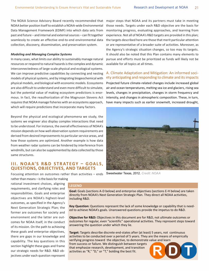
A. Climate Adaptation and Mitigation: An informed soci-ety anticipating and responding to climate and its impactsProjected future climate-related changes include increased global air and ocean temperatures, melting sea ice and glaciers, rising sea levels, changes in precipitation, changes in storm frequency and intensity, and changes in atmospheric composition. these, in turn, have many impacts such as earlier snowmelt, increased drought,
LEgENDgoal: Goals (sections A-D below) and enterprise objectives (sections E-H below) are taken directly from NOAA’s Next Generation Strategic Plan. they direct all NOAA activities, including R&D.
Key Question: Questions represent the lack of some knowledge or capability that is need-ed to achieve NOAA’s goals. Unanswered questions provide the impetus to do R&D.
Objective for R&D: Objectives in this document are for R&D, not ultimate outcomes or outcomes for regular, even “scientific” operational activities. they represent steps toward answering the question under which they lie.
Target: targets describe discrete end-states after (at least) 5 years, not continuous activities to be conducted over a period of 5 years. they are the means of empirically verifying progress toward the objective, to demonstrate value and learn from success or failure. We distinguish between targets that emphasize research, development, and transition activities as “R,” “D,” or “t,” bolding the best fit.
Sweetwater Texas, 2012. Credit: NOAA

22 Five Year Research and Development Plan 2013-2017
altered river flow volumes, changes in growing seasons, declining air quality, and alterations in species’ abundance, distributions, and migration patterns. Many of these impacts have already been observed, and significant additional impacts from these changes are expected to affect nearly every sector of society, including water, energy, transportation, insurance, banking, forestry, tourism, fisheries, agriculture, infrastructure, and human health. A changing climate will alter the distribution and availability of water and other natural resources that the Nation depends on. Changes in climate are also expected to exacerbate non-climatic human impacts on fisheries and marine ecosystems, such as overfishing, habitat destruction, pollution, changes in species distributions, and excess nutrients in coastal waters. increased sea levels lead to amplified storm surge, putting low-lying areas at risk. the direct impact of climate change on commerce, transportation, society and the economy is demonstrated by retreating sea ice in the Arctic, which has made coastal communities, including tribes, highly vulnerable to winter storms and coastal inundation, forcing many to begin planning to move inland.
Key Question: What is the state of the climate system and how is it evolving? to fully understand how the climate is changing, we must first have the observations that can clearly show us the current state of the full climate system; that is, monitoring our planet’s atmo-sphere, oceans, ice sheets, land surfaces, and so forth through time. integrated global observing systems are used to monitor climate variations, identify trends from a historical perspective, understand Earth’s climate as a system, and improve predictions at global and regional scales. Reliable and timely access to climate data and information is essential to improving understanding of key physical processes of the climate system, improving climate prediction and projection models, and regularly producing integrated analyses of the climate system and reporting on the causes and consequences of observed climate variability and climate extremes. Data and analysis produced from the climate observing network benefits virtually every sector of the nation’s economy as well as across all of NOAA’s Mission goals.
Objective for R&D: Sustained climate record. NOAA will con-tinue to provide the Nation and the world with an unambiguous measure of the state of the climate through uninterrupted, high quality in situ and remotely-sensed observations of primary vari-ables describing the ocean, atmosphere, and other components of the climate system. Up-to-date and accurate knowledge of the state of the climate is critical to sustaining the Nation’s economy (e.g., transportation, agriculture, fisheries), communities (e.g., health, land use) and ecosystem services (e.g., storm protection, tourism, habitat) in a changing world. Meeting NOAA’s mission to protect lives and property from weather hazards in a changing climate requires a dedication to maintaining the legacy of critical
and pioneering long-term surface observations of climate and atmospheric composition, improving the quality control, accura-cy, and consistency of these observations, and providing support for global change basic research that provides the backbone for applied needs in climate adaptation. NOAA must sustain and build out its longstanding observations, data management, and monitoring of the oceans and atmosphere to enhance the fundamental scientific understanding and knowledge of our climate to help people make informed decisions. Priority should also be given strengthening synergies between observations and modeling for more effective use of existing resources.
Over the next 5 years, NOAA aims to:
• Advance research on technological solutions for climate observations and the data they produce to improve the lifecycle, timeliness, and accuracy of these observations
• Assess collected climate data for quality, uncertainty, and the implications for impacts; make data and sub-sequent products available to users
• Develop and test improved climate observing systems in the deep ocean and Alaska
• Develop sensors and robotic floats for biogeochemical, biooptical, and pH measurements
Objective for R&D: Atmospheric and oceanic observations integrated into Earth System modeling. Atmospheric climate models and even coupled atmosphere-ocean models are giving way to Earth System Models (ESMs) that advance our understanding of how Earth’s biogeochemical cycles, includ-ing human actions, interact with the climate system. As the models become more complex, the data needed to evaluate and validate the models also becomes more complex and wide ranging. For example, the atmospheric component of the ESMs includes features such as atmospheric chemistry, aerosols (both natural and anthropogenic), cloud physics, and precipitation. the land component includes precipitation and evaporation, streams, lakes, rivers, and runoff as well as a terrestrial ecology component to simulate dynamic reservoirs of carbon and other tracers. the oceanic component includes features such as free surface to capture wave processes; water fluxes, or flow; cur-rents; sea ice dynamics; iceberg transport of freshwater; and a state-of-the-art representation of ocean mixing as well as marine biogeochemistry and ecology.
Over the next 5 years, NOAA aims to:
• Synthesize observations with models for reporting on the state of the climate system

23 Environmental Understanding to Ensure America’s Vital and Sustainable Future Research and Development at NOAA
• integrate observations into short- and long-time scale modeling processes for characterizing the seasonal to multi-decadal scale variation of the climate system and assessing its predictability
Key Question: What causes climate variability and change on global to regional scales? improved understanding of the causes of climate variability and change is vital to achieving NOAA’s mission. Such understanding provides a rigorous scientific basis for explaining observed climate trends and variations, as well as a foundation for improving models used in climate predictions and climate change projections.
Objective for R&D: Improved understanding of interactions and processes of key oceanic, terrestrial, and atmospheric components of Earth’s climate system. As knowledge of the cli-mate system deepens, an increasing array of processes and their interactions are being recognized and considered as important in understanding the causes of climate variations and change. Major factors include changes in atmospheric composition, the role of the ocean and atmosphere-ocean interactions, atmo-sphere-land surface interactions including hydrological process-es, the role of the cryosphere and interactions with ecosystems and organisms. the processes extend across space and time scales, as do decision-maker needs, from information needed to prepare for extreme events on time scales of a season or less, to adaptation and mitigation policy decisions on time scales out to decades. Developing a more comprehensive understanding of climate processes and mechanisms, and their relative impor-tance in explaining observed climate variations and change, will be essential to increasing confidence and credibility in climate predictions and projections. Such knowledge will also provide an improved scientific basis for characterizing associated uncer-tainties in predictions and climate change projections.
Over the next 5 years, NOAA aims to:
• Assess the roles of natural variability (e.g., solar chang-es, volcanic eruptions) and changing radiative forcing (from greenhouse gases and aerosols) in causing ob-served seasonal-to-multidecadal scale changes in the climate system
• Assess climate-induced changes in tropical and extra-tropical cyclones and their associated storm surges
• Assess climate-induced changes in droughts and heat
waves • Assess the potential for rapid changes in land-based
ice sheets and their impact on global and regional sea level
• Perform model simulations of ocean, atmosphere, and land-surface processes to support climate-scale hydrologic forecasting capabilities
• Assess climate-induced changes on the hydrologic cycle in the extended Great lakes Basin, and its forecasted effect on water level variability
• Assess the climate influences of ocean basin properties on interannual and decadal predictability
• Assess the weather and climate features of the trop-ical oceans to achieve higher confidence in seasonal global and regional predictions (e.g., Madden-Julian Oscillation)
• Assess the mechanisms that control climate sensitivity to surface albedo, water vapor, and clouds
Objective for R&D: Identify the causes of climate trends and their regional implications. Because many of the effects of a variable and changing climate will be felt most strongly at re-gional-to-local scales, understanding and predictions of regional climate variations and trends must be improved and placed on a firm scientific foundation. Regional climate trends and extreme events that are unanticipated leave decision makers and the pub-lic poorly prepared for planning and adaptation. A particularly important requirement is to understand the causes of weather and climate extremes, and whether they are changing. Extreme events often have regionally varying manifestations, and cor-responding regional differences in decision-maker needs. For example, hurricanes and storm surges are a key concern on the U.S. Gulf and east coasts, droughts and severe convective storms adversely affect the Midwest, and potent extratropical storms that interact with deep plumes of tropical moisture often lead to heavy precipitation events along the U.S. west coast. A ques-tion of compelling public interest is whether recently observed extremes reflect variability that is likely to return to previous conditions or rather are a sign of a new long-term climate trend. Addressing the complex science challenges that occur at regional scales will require multi-disciplinary expertise, necessitating collaborations across NOAA and with external partners.
Over the next 5 years, NOAA aims to:
• identify causes for the observed regional and season-al differences in U.S. temperature and precipitation trends and the relationships between trends in climate means and climate variability, especially extreme events, for predictions and projections
• Clarify the contribution of climate-scale physical processes to extreme events and their variability and frequency

24 Five Year Research and Development Plan 2013-2017
• Assess the connections of polar and high latitude cli-mate variability and change with that of other regions, including the effects of declining sea ice on extratropi-cal climate
• Provide enhanced access to the current state-of-knowl-edge on the causes of regional climate trends and extreme events provided to the public and decision makers for planning, adaptation, and other applications
• Conduct assessments of climate impacts on regional communities and economic sectors
• Collaborate with economists to provide enhanced monitoring of the costs of weather and climate disas-ters
Objective for R&D: Improve understanding of the changing atmospheric composition of long-lived greenhouse gases and short-lived climate pollutants. NOAA will improve under-standing of changes in atmospheric composition to assess the climate forcings, sensitivities, and feedbacks of both long-lived greenhouse gases (e.g., CO2, N2O, CFCs) and short-lived climate pollutants (e.g., aerosols, tropospheric ozone) and associated uncertainties. improved measurements and analyses of the trends and distributions, sources, transport, chemical trans-formation, and fate of these climate-forcing agents will lead to more skilled models, which will yield better predictions and projections of future climate and its impacts at local, regional, and global scales. Due to their multiple roles in the atmosphere, an improved understanding of these climate-forcing agents and the processes that influence their distributions will yield addi-tional benefits for reducing air quality degradation and recovery of stratospheric ozone layer.
Over the next 5 years, NOAA aims to:
• Quantify emissions of methane, nitrous oxide and black carbon, and assess the effects of black carbon and organic aerosols on clouds
• Reduce uncertainty of North American CO2 flux esti-mates by 1%
• Evaluate the effects of four replacement compounds for refrigerants, solvents, and blowing agents on cli-mate and on the stratospheric ozone layer
• Assess the impact of stratospheric ozone incursions on the tropospheric ozone burden (i.e., climate effects) and on surface air quality in different regions of the U.S.
• Determine the effects of increasing emissions in dif-ferent regions of the U.S. (e.g. urban emissions, and oil and natural gas development activities emissions) on climate and regional air chemistry
Key Question: What improvements in global and regional climate predictions and projections are possible? Providing climate forecasts for multiple time-scales will enable regional and national managers to better plan for the impacts of climate variability, and provide projections to support policy decisions with objective and accurate climate change information. the Nation requires a seamless suite of environmental forecasts (i.e. predictions and projections) on a diversity of temporal and spatial scales, to understand and predict the impacts of climate variability, extremes and abrupt climate change. these forecasts will also allow NOAA to contribute to and participate in credible national and international assessments of future climate trends and change. the global environment includes not only the atmosphere, hydrosphere, cryosphere, biosphere, and lithosphere, but also land-ocean biogeochemical processes, ecosys-tems, atmospheric chemistry, and air quality. Bridging weather and climate and providing information that is integrated into ocean and coastal management will build on the synergies between NOAA, its Cooperative institutes (Cis), regional centers, and the external research community.
Objective for R&D: Earth System Models for seasonal to centennial predictions and projections at regional to global scales. NOAA will improve the skill of seasonal forecasts and delivery of information products (e.g., predictions, projections) for decadal to centennial time scales with quantified uncertain-ties. Additionally, NOAA will improve regional outlooks through downscaling approaches, high-resolution global climate model runs, multi-model ensembles, and better representation of key physical and biogeochemical processes, including ocean dynamics, with specification and quantification of uncertain-ties. Failing to fill the various modeling gaps in key physical and biogeochemical processes risks leaving decision makers with insufficient scientific support concerning future climate states. improved information will enable decision makers to properly address regional and local planning for the impacts of flooding and drought, declining air quality, siting of critical infrastructure in coastal communities, and managing natural resources with changing conditions of our oceans and other ecosystems.
Over the next 5 years, NOAA aims to:
• Develop higher-resolution coupled-climate models
• Develop a prototype decadal climate prediction system

25 Environmental Understanding to Ensure America’s Vital and Sustainable Future Research and Development at NOAA
• Develop sound modeling downscaling techniques for climate applications for multiple regional spatial and temporal scales, including an embedded and nested regional Earth system projection capability
• Develop models of greenhouse gases, atmospheric aerosols (including black carbon), and aerosol interac-tions that yield uncertainty in climate sink quantifica-tion and effects on climate forcing
• Perform prototype modeling of climate-stratospheric chemistry interconnections
• Develop models simulating the ocean biogeochemical systems and ocean climatic impacts at resolutions of 3-5 km
• Assess predictability and predictive skill for global experimental decadal-scale predictions that account for natural variability and the climate-forcing agents
• Develop an intraseasonal to interannual prediction system that builds on the currently experimental re-al-time National Multi-Model Ensemble system and incorporates advances in statistical methodologies and forecast initialization
• Develop seasonal outlooks and decadal to multidecadal projections of climate-related changes in U.S. ocean regions including projections for regional sea-level change
Key Question: How can NOAA best inform and support the Nation’s efforts to adapt to the impacts of climate variability and change? Adaptation efforts help to manage climate-related risks and minimize impacts to communities, ecosystems, and economies. the actions of putting into place the plans, policies, and regulations for adapting to climate variability and change are largely the respon-sibility of local and municipal governments, with guidance from state and federal agencies and the support of academic institutions, non-governmental organizations, private industry, and academic institutions. NOAA provides information, tools, and services to support decision makers at all levels to prepare for and respond to climate variability and change through adaptation.
Objective for R&D: Key impacts and vulnerabilities are identi-fied across regions and sectors. NOAA will advance understand-ing of impacts and vulnerabilities of human and natural systems to climate variability and change. this requires integrating NOAA’s capabilities in science (physical, natural, and social), services, and stakeholder engagement. NOAA is experiencing a rapidly growing demand for climate information at scales (e.g. local-to-regional) useful for decision and policy makers.
Over the next 5 years, NOAA aims to:
• Advance projects/activities focused on the impacts of climate variability and change on four societal challenge areas – weather extremes, water resources, coastal inundation, and sustaining marine ecosystems
• Strengthen and test climate-related vulnerability as-sessments of ecosystems and social/economic systems and tools and training for conducting vulnerability assessments with NOAA partners
• Develop mechanisms and networks (regional and sec-toral) to advance effective stakeholder engagement, communication, and collaboration with scientists and decision makers
Objective for R&D: Improved and sustained assessments of risks and impacts. NOAA will organize and strengthen capabili-ties in the sustained assessment of climate risks and impacts on physical, natural, and human systems. this work will leverage and inform existing assessment efforts (e.g., U.S. National Cli-mate Assessment, intergovernmental Panel on Climate Change). Assessments will be conducted in partnership with decision makers to ensure that their information needs are addressed.
Over the next 5 years, NOAA aims to:
• Sustain assessments of the impacts and risks of climate variability and change on U.S. and international regions and sectors, particularly those with high relevance to NOAA’s mission (e.g., water resources, coastal zone and marine resource management)
• Develop a system of indicators of climate impacts on ocean and coastal resources and other sectors
Objective for R&D: Climate information, tools, and services are developed and shared broadly to inform society’s preparedness and response efforts. the demand for NOAA’s climate informa-tion, tools, and services is increasing, as decision-makers work to prepare for the impacts of climate variability and climate change. Meeting this demand will require regular interaction between stakeholders and scientists.
Over the next 5 years, NOAA aims to:
• Develop visualization and decision-support tools for changes in ocean temperature, coastal inundation, and sea-level at decision-relevant scales

26 Five Year Research and Development Plan 2013-2017
• integrate county-level coastal and ocean job trends data via NOAA’s Digital Coast to enable decision makers and planners to better assess the economic impacts of climate change and extreme events
• Develop methods (including economic analyses) for evaluating the effectiveness of adaptation strategies and actions, particularly for coasts, oceans, and water resources
• improve communication and application of NOAA’s climate information to decision makers and the public through outreach, education, training, user-friendly online resources (e.g. climate.gov), social media, tools, and other pathways
B. A Weather Ready Nation: Society is prepared for and responds to weather related eventsA Weather Ready Nation is able to prepare for and respond to environmental events that affect safety, health, the environment, economy, and homeland security. Urbanization and a growing population increasingly put people and businesses at greater risk to the impacts of weather, water, and climate-related hazards. NOAA’s capacity to provide relevant information can help create a society that is more adaptive to its environment; experiences fewer disruptions, dislocations, and injuries; and that operates a more efficient economy.
Weather-Ready Nation emergency response vehicle unveiled at the National Weather Service’s New Orleans/Baton Rouge office. Credit: NOAA
Key Question: How can we improve forecasts, warnings and decision support for high-impact weather events?
Objective for R&D: Improved observations. the building blocks of the Weather Ready Nation are observations of the current state of the atmosphere. these form the basis of the future state of the atmosphere when assimilated into high resolution computer models which produce information upon which public forecasts and warnings are based. they are the underpinning of both tactical and strategic decision support. An incomplete picture of the atmospheric boundary layer, where most human activity occurs, represents a major gap in our ability to diagnose and predict high-impact weather events. Filling this gap will take more than the next 5 years, but significant milestones are in sight during this time frame.
Over the next 5 years, NOAA aims to:
• Establish rapid radar sampling technologies needed to produce robust ensemble-based numerical model warnings of severe weather with extended lead-times, up to one hour or longer
• integrate the National Mesonet with complete cover-age of surface meteorological stations over the conti-nental US, including soil moisture and solar radiation
27 Environmental Understanding to Ensure America’s Vital and Sustainable Future Research and Development at NOAA
• Develop the foundational infrastructure for a “Net-work of Networks” that provides boundary layer profiles of winds, temperature, and moisture
• Evaluate Collaborative Adaptive Sensing of Atmo-sphere (CASA)/Urban Demonstration Network and other partner technology of short-wavelength net-worked radars, adaptive sampling, and associated numerical weather prediction
• Operationalize the geostationary lightning mapper (GOES-R)
• Develop Global Hawk Unmanned Aerial Systems configurations supporting multi-mission sensors in-cluding radiometer, lidar, spectrometer, dropsondes, and Doppler radar, with at least a 24-hour mission duration
• Conduct feasibility studies to fill major gaps in obser-vations of water cycle parameters (e.g., water vapor transport, precipitation, snow, river flow, sea-ice, waves, water level, surface energy budget terms including evapotranspiration and aerosols)
Objective for R&D: Integrated real-time analyses of weather conditions. NOAA will develop tools and algorithms needed to integrate data from diverse observational platforms (NOAA and partners) into rapidly updating, storm-scale information. integra-tion of available observations from diverse platforms, sensors, coverage, and both internal and external providers is needed to meet goals to provide storm-scale information critical to meeting goals for forecasts and warnings of high-impact weather goals.
Over the next 5 years, NOAA aims to:
• Prototype coupled fire weather and fire behavior mod-eling system for local firefighting applications
• implement a prototype of a rapidly updating 3-di-mensional state-of-the-atmosphere analysis system
• transition the Meteorological Assimilation Data ingest System to operations
• transition the Multi-Radar-Multi-Sensor real-time analysis system to operations
Objective for R&D: Improved predictive guidance. One of the scientific success stories of the 20th century is the development of numerical weather prediction models; today, NOAA produces weather forecasts of proven utility out to a week based on these models. On the other hand, tornado warnings are not issued on the basis of forecasts, but rather upon observed evidence. today’s science and technology do not yet allow scientists to describe the genesis of a tornado, model it, and predict its path,
a capability that could save many additional lives. Similarly, while we have dramatically improved the prediction of the track of hurricanes in recent years, progress in improving forecasts of hurricane intensity, and associated storm surge and rainfall has been slower. in addition, significant R&D is needed to present NOAA weather forecasts in a probabilistic framework that allows for the proper communication of forecast uncertainty and to enable a wide range of risk-based decision-making.
Over the next 5 years, NOAA aims to:
• Develop a global deterministic forecasting system at a resolution of 10 km and the associated ensemble forecast system at a resolution of 20 km
• Determine the impacts of stratospheric resolution on simulations of slowly varying tropospheric weather patterns such as the Arctic Oscillation (AO) and the Pacific North Atlantic teleconnection pattern
• Evaluate the impact of ocean-atmosphere coupling on short-range weather forecasts
• implement a moveable inner nest for hurricanes within the operational global forecast system
• Determine the relative merits of different approaches to ensemble generation including multi-model, sto-chastic physics, and multi-physics
• identify the most effective way to represent initial condition uncertainty for NOAA’s forecast models, i.e. EnKF ensemble members versus the breeding method
• implement advanced statistical methods for post-pro-cessing ensemble guidance to accurately quantify uncertainty and improve reliability
• Prototype a unified (tide-waves-estuarine-surge) probabilistic inundation model for both tropical and extratropical storms
• Conduct a multi-year reanalysis of Doppler radar data to establish convective storm behavior climatologies
Objective for R&D: Improved decision support tools. NOAA is embarking on a major enhancement and expansion of its decision support services to better realize the benefits of its weather fore-casts and warnings. For decision makers, the Agency will improve the communication of weather, water and climate impacts and risks, as well as develop impact-based communication capabilities. in addition, NOAA will incorporate quantified uncertainty and risk information into its forecasts to facilitate analyses for strategic and tactical preparation and effective response. limiting weath-er-related loss of life and property requires eliciting the most effective response to accurate, reliable warnings and forecasts.
28 Five Year Research and Development Plan 2013-2017
Next-generation warning concepts will be developed and tested to improve these desired societal responses through the delivery of quantitative and user-specific information. the target operational system for all these tools is the Advanced Weather interactive Processing System (AWiPS). Over the next 5 years, NOAA aims to:
• Prototype a comprehensive operational it forecaster decision support environment for WRN operations
• Deploy a unified public warning tool into operations
• implement initial capability to allow external users to be notified when thresholds for their weather-based decisions have been exceeded in either current or future weather conditions
• improve air quality modeling of fine particulate mat-ter from wildfires, dust storms, and other pollution sources
• Prototype coupled evacuation route-inundation-storm surge model for targeted regions of the Gulf Coast
• Prototype warning methodologies that capitalize on future output from storm-scale models
• Evaluate experimental products from which tornado warnings with lead times greater than 1 hour can be generated
• Develop risk communication tools based upon behav-ioral research on the timing and effectiveness of public response to weather warnings
Key Question: How does climate affect seasonal weather and extreme weather events? in order to be prepared for and respond to weather-related events, warning in advance of these events is critical. the longer lead time of the warning, the more prepared society can be. While deterministic weather predictions provide information on events out to seven days, it is climate predictions that enable society to adequately prepare for impending changes in the weather on longer time-scales. Knowledge of the state of the climate system provides general guidance on what society can expect during a season as changes in climate patterns affect seasonal weather and extreme events by impacting the frequency and intensity of events. improving our understanding of the climate linkages to weather and extreme events, and improving our capability to predict climate will improve our ability to enable society to respond to upcoming weather events well in advance of extreme conditions. Our ability to improve prediction and understand the nature of the predictability of events must evolve through research, improved models, observations, and monitoring of the climate, leading to
reliable estimates of the confidence in predictions and projections across relevant time and space scales.
Objective for R&D: Apply understanding of weather and climate extremes and the weather-climate linkage to improve preparedness and response. With a greater understanding of the climate-weather linkage, all sectors of society will be better prepared for extreme events. Coastal communities and related industries, environmental resource managers, national, regional, state, and local governments, and the public will have longer lead times to prepare for the impacts of hazardous weather events. in the past 10 years, knowledge and predictability of climate and its impacts on weather has evolved, but with the changing climate and the recent onslaught of extreme weather events, it is critical to improve our understanding of climate-weather linkages.
Over the next 5 years, NOAA aims to:
• integrate understanding of the physical processes of Madden-Julian Oscillation events, atmospheric rivers, predictability of AO/North Atlantic Oscillation, and tropical convection, into operational forecast products
• incorporate local and regional climate impacts into extreme meteorological and hydrological event fore-casts
• Expand the local Climate Analysis tool to include multiple time and space scales for delivery of informa-tion in support of regional and local decision making
Key Question: How can we improve space weather warnings? When storms in outer space occur near Earth or in Earth’s upper atmosphere, we call it space weather. Rather than the more com-monly known weather within our atmosphere (rain, snow, heat, wind, etc.), space weather comes in the form of radio blackouts, solar radiation storms, and geomagnetic storms caused by solar disturbances from the Sun. Earth’s magnetic field helps to protect us from the effects of some solar storms, but strong solar storms can cause fluctuations of electrical currents in space and energize electrons and protons trapped in Earth’s varying magnetic field. these disturbances can cause problems with radio communications, Global Positioning Systems (GPS), power grids, and satellites. As we become more dependent on technology, the need for space weather monitoring and forecasting becomes more important.
Objective for R&D: Improved accuracy of 1-4 day forecasts of geomagnetic storms. the energy for geomagnetic storms originates from the sun in the form of a Coronal Mass Ejection (CME). it takes several days to propagate to Earth. improving the

29 Environmental Understanding to Ensure America’s Vital and Sustainable Future Research and Development at NOAA
detection and assessment of CME’s through observations with operational coronagraphs will greatly improve NOAA’s ability to forecast geomagnetic storms, which can disrupt the Nation’s power grid, wireless communication network, and transportation infrastructure. Measuring and tracking the magnetic configu-ration within the CME will greatly improve the accuracy of the forecasts of the strength of the resulting geomagnetic storm.
Over the next 5 years, NOAA aims to:
• Develop an operational coronagraph flown and sup-ported within the NOAA satellite program
• Develop methods of estimating the magnetic field configuration within a CME
Objective for R&D: Localized specification and forecasts of the impacts of geomagnetic storms at ground level. Critical customers, such as electric power companies, have requested specific improve-ments in space weather forecasts, such as regional specification and forecasts of the impact of geomagnetic storms (currently only the global index of the strength of the storm is provided). Research is underway, in partnership with the USGS and NASA, to gather regional information from a network of ground observations and develop maps of the impact of geomagnetic storms. Forecasting these regional impacts requires the introduction of a new Geospace model into operations. R&D activities are underway in collaboration with NASA to evaluate and test models from the research commu-nity for transition into operations.
Over the next 5 years, NOAA aims to:
• Develop and test the DSCOVR spacecraft and ground data processing system to insure continuity of so-lar wind observations that drive Geospace models
• Develop regional and local specification of the geo-magnetic conditions relevant to the National electric power grid
• identify the best Geospace model for forecasting local geomagnetic storm conditions and begun the transi-tion of this model into operations
Objective for R&D: Predictions of ionospheric conditions relevant to Global Navigation Satellite System users. the observation and modeling of ionospheric structures that modify or block the signals from radio navigation systems such as Global Positioning System is critical to providing customers with the services they are requesting. Global Radio Occultation (RO) observations will provide key inputs to the products and models. Developing a Whole Atmosphere Model (WAM) coupled with
an ionosphere-Plasmasphere-Electrodynamics model (iPE) will provide the necessary framework for forecasting ionospheric conditions.
Over the next 5 years NOAA aims to:
• Develop assimilative models for COSMiC ii data
• Couple NOAA’s operational WAM (e.g. the extended Global Forecast System) to the ionosphere Plas-masphere Electrodynamics model (iPE)
• Assess the impact of data assimilation in iono-sphere-thermosphere forecast modeling
Objective for R&D: Improved specification and forecasts of the radiation environment for satellites and commercial aircraft. Satellite operators have requested products that turn localized NOAA satellite measurements of the radiation environment into global actionable information on how the environment may damage satellite systems. New products to monitor and forecast radiation exposure for air traffic are sought by commercial airline operators and crew. these new products require modeling of the radiation environment. Current research models provide some utility but a full assessment of model capability and accuracy is needed.
Over the next 5 years NOAA aims to:
• Develop models that predict the radiation environ-ment at aircraft and satellite altitudes
Key Question: How can we improve forecasts for freshwater resource management? Managing freshwater quantity and quality is one of the most significant challenges the U.S. must address. De-mands for water continue to escalate, driven by agricultural, energy, commercial, and residential usage. Sustained growth requires viable long-term municipal water supplies and, by extension, sophisticated predictions and management practices. the Nation’s water resource managers need new and better-integrated information to manage water more proactively and effectively in a changing and uncertain environment. NOAA predicts where, when and how much water will come from the skies as rain or snow and move through the rivers and streams. Additionally, NOAA manages the U.S. coastal and marine systems that receive water from the land and rivers as it flows back to the sea. NOAA and its partners will enhance the integration and utility of water services by developing integrated decision-support tools for water resource managers based on high-resolution summit-to-sea data and information.

30 Five Year Research and Development Plan 2013-2017
Objective for R&D: Increased hydrologic forecast skill from low to high streamflow conditions to match skill afforded by weather and climate predictions. the foundation of improved fresh water resources management is improved hydrologic fore-casting. Significant advances in hydrologic prediction demand a more complete understanding of the physical processes key to storms and floods. this knowledge must in turn be incorporated into improved numerical hydrologic prediction models.
• Diagnose the variability of water vapor transport in atmospheric rivers
• identify extreme precipitation and precursor land-surface conditions that amplify or reduce drought and flood severity
• Unify a large-scale hydrological modeling system allowing integrated and multiscale predictions, projections and analyses
• Develop high-resolution hydrologic products that directly link atmospheric and land-surface processes and depict the full water cycle over the U.S.
• Conduct a national water cycle reanalysis
C. Healthy Oceans: Marine fisheries, habitat, and bio-diversity are sustained within healthy and productive ecosystemsCoastal communities are dependent upon ecosystem services provided by healthy and productive coastal and marine ecosystems. they provide food, recreational opportunities, and support for econ-omies, yet the resources from our marine, coastal, and Great lakes environments are stressed by human uses. Habitat changes have depleted fish and shellfish stocks, increased the number of species that are at-risk, and reduced biodiversity. Humans are an integral part of the ecosystem, so declines in ecosys-tem functioning and quality directly impact human health and well-being. As long-term environmental, climate, and population trends continue, global demands for seafood, energy, recreational use of aquatic environments, and other pressures on habitats and over -exploited species will increase alongside concerns about the sustainability of ecosystems and safety of edible fish. Depleted fish stocks and declines in iconic species (such as killer whales, salmon, and sea turtles) result in lost opportunities for employment, economic growth, and recreation in coastal and marine waters. in addition, climate change impacts to the ocean, including sea level rise, acidification, and warming, will alter habitats and the relative abundance and
distribution of species. Climate change poses serious risks to coastal and marine ecosystems productivity, which subsequently affects recreational, economic, and conservation activities.
Key Question: How do environmental changes affect marine ecosystems? the living marine resources under NOAA’s purview, their habitats, and the coastal communities and economies that depend on them exist within ecosystems constantly changing due to environmental variability, climate change, and human activities such as: resource exploitation, development, and pollution. these changes affect species’ distributions, migration, reproduction, growth rates, levels of primary and secondary production, and overall habitat suitability. A better understanding of how ecological interactions are affected by environmental change and human interactions will enable more certain assessments and forecasts, leading to improved management that ensures sustainable, healthy and productive marine ecosystems.
Objective for R&D: Increase our knowledge of the physical and chemical changes in the oceans resulting from atmospheric, ocean, and land-based forcing. Providing regional forecasts and projections requires understanding how physical and chemical variables across the ocean and watershed conditions change, assessing these conditions, and developing the capability for prediction. these forecasts and projections are critical toward incorporating environmental information into marine resource management. Species inhabit certain regions because they are adapted to the environmental conditions typically present there.
The NOAA Ship Reuben Lasker will assess fish.stocks and study other marine life, including marine mammals and sea turtles, on the U.S. West Coast. Credit: Val lhde, Marinette Marine Corp.

31 Environmental Understanding to Ensure America’s Vital and Sustainable Future Research and Development at NOAA
Over the next 5 years, NOAA aims to:
• increase collection and use of high-quality environ-mental data in describing and understanding the dominant forcings of the oceans and their physical and chemical impacts
• increase collection and use of high-resolution, re-gionally constrained environmental data to support regional forecasts and projections
Objective for R&D: Increase our knowledge and understanding of the mechanisms and impacts of environmental changes on marine species and ecosystems. the National Ocean Policy establishes ecosystem-based management (EBM) as a foundational principle for ocean resource management in the United States. Understanding how environmental changes affect marine ecosystems provides the scientific underpinning of EBM and is crucial for sustaining marine fisheries, habitat, and biodiversity within healthy and productive ecosystems. Human activities and climate change can impact population connectivity and this needs to be taken into account when implementing management measures. the success of management measures (e.g., HAPCs, MPAs, and MPA networks) to protect, conserve, and restore marine habitats or populations hinges on the establishment of ecologically relevant boundaries that take into account propagule (spores, eggs, and larvae) connectivity, as well as the movements of juveniles and adults. A combination of retrospective and process studies, monitoring and modeling are required to advance our understanding of the impacts of environmental change. NOAA must understand the mechanisms by which environmental change impacts marine species and ecosystems to confidently predict or project the impacts. Without this mechanistic understanding, there is no basis for predictions or projections when conditions change, resulting in uncertain assessments and forecasts. Observations coupled with information from retrospective and process studies generate the necessary foundation for understanding environmental-ecosys-tem relationships. Combining this information with ecosystem models that include environmental forcing also contributes to understanding the mechanistic linkages between environmental forcing and species’ responses.
Over the next 5 years, NOAA aims to:
• Decrease uncertainty in the forecasts generated from ecosystem models
• Develop analytical models and tools to understand and quantify impacts of environmental change in three large marine ecosystems
Objective for R&D: Incorporate environmental change information into operational marine resource assessments and decision-making. A stronger scientific basis for improved marine resource management requires increased incorporation of environmental change information into operational assess-ments and decision-making. to transition to EBM, the increased knowledge obtained through the first two objectives must be incorporated into operational assessments and the decision making process. the increased knowledge will advance the development and testing of indicators and models to predict with greater certainty the probable consequences of environmental changes on regional ecosystems. Some of these indicators or derived parameters may be incorporated directly into next generation stock assessments. Moreover, the development of ecosystem assessments and management strategy evaluations that incorporate environmental and climate change information and evaluate different ecosystem management strategies will provide resource managers with information to make more cost-effective and informed decisions in an ecosystem context.
Over the next 5 years, NOAA aims to:
• Develop regional-scale ecosystem models driven by regional-scale climate models
• Develop next-generation stock assessments that incor-porate the effects of environmental change on stock dynamics
• Develop protected species and habitat valuation for regions identified in the Habitat Blueprint
• Assess social and economic benefits of fish stocks and the potential trade-offs associated with managing competing ecosystem services or allocating an ecosys-tem service among competing user groups
Key Question: How is the chemistry of our ocean changing and what are the effects? Recognizing that there are a diversity of influences on the state of coastal and marine ecosystems, there is mounting evidence that ocean acidification driven by increasing CO2 levels could have significant effects on global marine ecosystems, which warrants focused attention. Effectively forecasting the long-term and ecosystem-level effects of ocean acidification is an emerging challenge. Short-term and resident factors controlling car-bon chemistry (e.g. upwelling, riverine discharge, nutrient loading) can further exacerbate global acidification at local scales. long-term chemical observations necessary to track ocean acidification are limited especially within dynamic coastal environments. Critical research needs remain in order to confidently incorporate ocean chemistry into ecosystem forecast models.

32 Five Year Research and Development Plan 2013-2017
Objective for R&D: Understand the processes of ocean acidifi-cation and its consequences for marine organisms, ecosystems, and human communities. As atmospheric CO2 continues to rise, ocean chemistry is fundamentally altered through the continual uptake of excess carbon. Changes include acidifying surface waters (i.e. reduced pH), enriching them in CO2, and making the waters less supersaturated with respect to carbonate minerals. Many marine ecosystems may be susceptible to ocean acidification, particularly organisms partly composed of calcium carbonate (a chalk-like mineral) such as foraminifera, clams, oysters, mussels and corals. local processes can exacerbate glob-al-scale ocean acidification such as coastal upwelling along the west-coast of the U.S. Here, acidified waters likely contributed to a recent crisis in larval supplies in the Northwest’s shellfish industry. Much research is needed before we can fully under-stand the broader impacts to marine life and human societies. Understanding acidification and predicting the consequences for marine resources and ecosystem services is critical to carbon mitigation discussions and to aid local communities in better preparing and adapting to ocean acidification.
Over the next 5 years, NOAA aims to:
• Develop bio-economic models informed by targeted experimental studies to forecast ocean acidification impacts on federally managed and Alaska managed crab species
• Conduct ocean acidification vulnerability assess-ment of California Current food webs and economics
• Establish long-term high quality monitoring capabil-ities of ocean acidification and ecosystem response
• implement coupled biogeochemical and ecological coral reef ocean acidification status and trends diag-nostic monitoring as a key attribute of the National Coral Reef Monitoring Plan within each U.S. coral reef jurisdictions
• Provide scientific stewardship of comprehensive ocean acidification data
Key Question: What exists in the unexplored areas of our oceans? the ocean remains largely unexplored. Because of this, answers to this key question will expand NOAA’s and the Nation’s knowl-edge and understanding of marine biodiversity, biogeochemical processes, ecosystems, living and non-living marine resources, and ocean-climate interactions at local to global scales. this new knowledge will inform current and future research and technology initiatives, marine policy and management decision-making, private sector interests, and the public at large. NOAA facilitates ocean discoveries and the development of new technologies. in addition, the Agency transfers this new knowledge to operational use within the Agency and shares it with partners in ocean exploration and management.
Objective for R&D: Map and characterize ocean basin bound-aries. Ocean boundaries include those with the solid Earth (e.g., the seafloor, ridges, canyons, faults, and seamounts), the atmosphere (e.g., air-sea interface), ice (e.g., ice types and ages, keels, ridges, shelves, icebergs) and boundaries within the water column itself. Processes occurring at these boundaries have economic, safety (e.g., natural hazards), scientific, and cultural importance. Characterizing ocean basin boundaries requires using advanced technologies and systems, including autonomous underwater vehicles, multi-beam sonar, side-scan sonar, and other advanced seafloor and water column sensors and mapping technologies.
Over the next 5 years, NOAA expects to:
• Explore poorly-known or unknown regions in support of the U.S. Extended Continental Shelf Project and in the Expanded U.S. Exclusive Economic Zone in the Mid-Atlantic, Gulf of Mexico, Caribbean, West Pacific, and Arctic
• Develop and apply technologies and systems to docu-ment ocean basin boundaries in areas defined above and provide ecological baseline characterizations of these areas The NOAA Ship Okeanos Explorer prepares to depart for the
Northeast U.S. Canyons 2013 Expedition. Credit: NOAA Okeanos Explorer Program, 2013 Northeast U.S. Expedition
33 Environmental Understanding to Ensure America’s Vital and Sustainable Future Research and Development at NOAA
Objective for R&D: Discover and characterize new ocean resources NOAA continually seeks to discover, observe, and describe new species, communities of organisms, and resources, both living and non-living. these include species and resources of economic importance and/or benefit to humanity (e.g., natural products for pharmaceutical or biotechnology applications; new hydrate, seep, or microbial environments; cultural/archaeolog-ical resources; fish stocks and baseline biodiversity inventories; valuable mineral resources).
Over the next 5 years, NOAA aims to:
• Discover and characterize new habitats and biologi-cal communities including microbes associated with hydrothermal vent communities, mesophotic and deep-sea coral habitats, and methane seeps and communities
• identify new natural products derived from deep sea biota and marine microbes
• identify undiscovered areas of the ocean with poten-tial high concentrations of economic assets
• locate new underwater cultural and archaeological heritage sites in U.S. territorial waters for Federal management
Objective for R&D: Transition ocean exploration discoveries to the rest of NOAA and other agencies. Results from exploration will highlight areas, resources, or processes that are new to ocean science or in need of further study. By design, these discoveries will directly apply to NOAA mission areas and many of these will benefit other agencies for further research.
Over the next 5 years, NOAA aims to:
• Complete the Atlantic Canyons Undersea Mapping Expeditions (ACUMEN) Project in support of the NOAA Habitat Blueprint Northeast regional initiative
• Provide baseline characterization information for the establishment of marine protected areas for sensitive deep-sea coral ecosystems in the Atlantic, Pacific and Gulf of Mexico
• Explore mid-Atlantic deepwater hard bottom habitats and shipwrecks with emphasis on canyons and coral communities as part of a joint project with the Bureau of Ocean Energy Management
• Characterize marine archaeological discoveries of cultural or archaeological significance
Key Question: How can emerging technologies improve eco-system-based management? in order for an ecosystem-based approach to be successful in meeting its management objectives, it requires a synthesis of scientific information from relevant physical, chemical, ecological and human processes in relation to specified marine ecosystem management objectives. the intent is to understand the effects of these processes on the sustainability of living marine resources, production of marine ecosystems, and health of the oceans. this information is necessary to establish target levels and thresholds for important ecosystem components, and evaluate the impacts of management options and risks of not attaining these target ecosystem states. Policy decisions for fishery management and protection of endangered species require improved scientific information from various spatial and temporal scales. Current sampling technologies need improvement in their survey capabilities to provide more accurate and precise synoptic information of key marine populations and environmental influences on their production and distribution.
Objective: Improve survey capabilities to provide more accurate, precise and synoptic information of key marine popu-lations. improvements are needed to advance survey capabilities to provide more accurate, precise, and synoptic information of key marine populations and environmental influences on their production and distributions using innovative technologies. Remote sensing and alternative platforms can improve survey coverage without significant increases in expensive ship time.
Over the next 5 years, NOAA aims to:
• Decrease uncertainty in the forecasts generated from ecosystem models
• Enhance UAS camera systems for marine mammal surveys
• Operationalize animal-borne observing systems at the scale of NOAA’s regional ecosystems
Objective for R&D: Improve biomass and mortality estimates and address measurement uncertainty with technologies aboard existing surveys. improving abundance estimates and addressing measure uncertainty requires the development and implementation of technologies used in existing surveys, and pertinent environmental and ecological measures.
Over the next 5 years, NOAA aims to:
• increase the frequency of ecosystem-process studies that employ advanced sampling technology
• Decrease uncertainty in the forecasts generated from ecosystem models
34 Five Year Research and Development Plan 2013-2017
Objective: Develop integrated models that take advantage of synoptic data at various scales, to inform ecosystem-based management approach. Data from emerging sampling tech-nologies will provide synoptic information to develop biological models capable of providing regional-scale assessments and forecasts of biological productive.
Over the next 5 years, NOAA aims to:
• Decrease uncertainty in the forecasts generated from ecosystem models
Key Question: How can we ensure aquaculture is sustainable? NOAA’s responsibility as steward of our nation’s living marine resources includes fostering the development of marine aquaculture for a variety of purposes – to supply seafood and other marine products for our entire nation; to create employment and business opportunities in coastal communities; to help support domestic wild fisheries, such as salmon, through hatcheries; to preserve and rebuild threatened and endangered species such as abalone; and to restore habitats such as oyster reefs. Considering that the U.S. imports 91% of its entire seafood supply, with almost half of those imports being foreign aquaculture products, it is clear NOAA needs to encourage and enhance domestic seafood production. By increasing and enhancing the capabilities of domestic aquaculture production of marine fish, shellfish, and plants and encouraging consumers to buy domestic seafood we can ensure that what is on consumers’ plates benefits the U.S. economy and has been properly and sustainably managed and produced.
Objective for R&D: Enhance current species culture methods and identify new commercially viable species. increasing the aquaculture capacity of the U.S. to compete with foreign nations and improve culture methods domestically will not only enhance the sustainability of our products, but also increase the variety of seafood available. increasing the accuracy and ability to monitor and evaluate culture methods will ensure that these practices are done in a smart way. in order to do so, NOAA will need to increase capacities encouraging expansion of aquaculture options.
Over the next 5 years, NOAA aims to:
• Develop and transfer culture technologies for com-mercially viable marine aquaculture species
• Develop aquaculture methods for species with high potential commercial viability
• Objective for R&D: Supporting aquaculture as an effective tool for improving coastal community economies and improving habitat quality. NOAA is committed to increasing our ability to
continue conducting aquaculture practices sustainably. Along with providing jobs and economic opportunities, aquaculture is a tool that can be used for improving and monitoring habitat quality. Shellfish, such as oysters, clams, and mussels, remove excess nutrients from the water column and can be used as bioremediation tools.
Over the next 5 years, NOAA aims to:
• Assess the potential of restoration and wild fishery enhancement as bioremediation tools
• identify the social and economic impacts of marine aquaculture on U.S. coastal communities
Objective for R&D: Create new technologies for better siting aquaculture facilities. improving our current ability to under-stand the impacts of commercial aquaculture on the environ-ment will help limit these impacts by placing facilities in areas that do not interfere with other coastal resources. increased knowledge of proper site selection is critical for sustainability. Water quality impacts are likely to be minimal at offshore fish farm sites that are sited in deep, well-flushed water. technologies such as ecological models and GiS databases of coastal use areas will enable sustainable choices.
Over the next 5 years, NOAA aims to:
• Develop models to assess the environmental impacts and the technical feasibility of permitting offshore finfish culture
D. Resilient Coastal Communities and Economies: Coastal and Great lakes communities are environmentally and economically sustainablethe complex interdependence of ecosystems and economies will grow with increasing uses of land, marine, and coastal resources, resulting in particularly heavy economic and environmental pressures on the Nation’s coastal communities. Continued growth in coastal populations, economic expansion, and global trade will further increase the need for safe and efficient maritime transpor-tation. Similarly, the Nation’s profound need for conventional and alternative energy presents many economic opportunities, but will also result in greater competition for ocean space, challenging our ability to make informed decisions that balance conflicting demands as well as economic and environmental considerations. At the same time, the interdependence of ecosystems and economies makes coastal and Great lakes communities increasingly vulnerable to chronic – and potentially catastrophic – impacts of natural and

35 Environmental Understanding to Ensure America’s Vital and Sustainable Future Research and Development at NOAA
human-induced hazards, including climate change, oil spills, HABs, pathogen outbreaks, and severe weather hazards.
Key Question: What is the value of coastal ecosystems? Ecosystems services are valued for life support functions, aesthetic and spiritual significance, sustaining wildlife habitats, reducing environmental and human health risks, and their sheer irreplaceability. in totality, valuation of ecosystem services is difficult to quantify and as such, it is often omitted from traditional economic analyses and discounted in policy decisions. However, there are techniques available that can help us to understand the benefits a healthy ecosystem provides, both in terms of market value for industries such as fisheries, energy and recreation, as well as non-market valuation of services that are not as easily quantified. Advancing and implementing these techniques will result in more accurate information on the comprehensive value that ecosystems provide. Our coasts are where the land meets the sea, and are an appropriate place to describe how NOAA ecosystem service valuation (ESV) efforts will cut across resilient coastal communities and economies, healthy oceans, climate mitigation and adaptation, and a Weather Ready Nation.
Objective for R&D: Improved understanding of the economic and behavioral elements of coastal resilience. NOAA will estimate the value of ecosystem services to inform management decisions, apply ocean and coastal economic data to better understand the economic importance of the coast and the
dependence of the economy on coastal and ocean ecosystems, produce information on economic losses due to coastal hazards to help mitigate negative impacts, and assess and understand behaviors related to climate change impacts toward increased community and economic resiliency. the sustainability and resilience of coastal communities and economies depends on healthy ecosystems and a clear picture of the connection between society and the natural capital provided by ecosystems.
Over the next 5 years, NOAA aims to:
• identify best practices and incorporated Common international Standards for Ecosystem Services in economic valuation studies
• Conduct risk-based analyses of hazards to coastal com-munities and ecosystem services in a pilot area, using best practices and innovative approaches
• Develop socio-economic indicators of coastal com-munity well-being and vulnerability to industrial development and environmental change, and apply the indicators in developing regional ecological char-acterization reports
• Build integrated water level models, and evaluate costs and benefits of transitioning the coastal storm surge model (surge plus wave prediction) to operations
Alaskan harbor, Valdez, Alaska. Credit: Alaska Sea Grant

36 Five Year Research and Development Plan 2013-2017
• Characterize climate sensitivity of selected National Estuarine Research Reserve System sites using social vulnerability and biophysical indicators
• Develop estimates of monetary and social costs of hy-poxic zones, regions experiencing HABs, and designat-ed Areas of Concern (AOCs) in lake Michigan
Key Question: How do coastal species and ecosystems respond to habitat loss, degradation and change? Coastal species respond to environmental stress at all levels of biological organization – from biochemical, physiological and histological aberrations, loss of a population or sub-population, and disruption of ecosystem structure and function. Greater scientific insight, improved measurement technologies and modeling now offer a suite of measurement to document stress at the sub-cellular levels, even from low levels of stress and with presumed causality. At this stage, response sensitivity is rapid and generally reversible. On the other hand, changes at the ecosystem level, even though highly relevant for resource management decisions, are difficult to discern and, when documented, indicate an altered or degraded state. Emerging data suggest that combined effects of multiple stressors, synergistic or otherwise, may be a more common occurrence in the field. NOAA will continue to improve and develop new methods to document ef-fects of environmental stressors on coastal species and ecosystems, and develop a cohesive program of research on multiple stressors.
Objective for R&D: Determine combined effects of environ-mental stressors on coastal species and ecosystems. Coastal ecosystems are affected by different environmental stressors, including extreme natural events, coastal subsidence and sea-level changes. these stressors, when coupled with land and resource use activities, cause changes in ecosystem structure and function that have proven difficult to assess or mitigate. it has not
been possible to determine combined effects of environmental stressors on coastal ecosystems, including those caused by myriads of toxic chemicals. New and developing technologies, including those based on genomics, DNA probes, immunological biomarkers, etc. are beginning to offer a common denominator or a suite of methods that could infer or quantify such impacts.
Over the next 5 years, NOAA aims to:
• identify sub-lethal effects, including metabolic and reproductive dysfunction and transcriptomic and proteomic changes in species under environmental stress
• Document the combined effects of multiple stressors on at least one coastal ecosystem and the valued species therein
• Characterize sources, transport, transformation and fate of mercury pollution in Mobile Bay
• Develop models that simulate contaminant transport from the watershed to coastal bays and estuaries
Key Question: How do we ensure that growing maritime commerce stays safe and sustainable? More than 350 commercial ports in the United States move some $3.8 billion worth of goods each day, and contribute significantly to the national economy in the form of personal income, infrastructure support, and ancillary jobs. A majority of that contribution is from 13 major ports. in addition, the economic impact of the North American cruise industry is approaching $40 billion per year. U.S. ports are located in different coastal environments, ranging from shallow estuaries on the East Coast (having a mean depth much lower than the dredged shipping lanes), constructed waterways leading to the Great lakes and the Gulf of Mexico, and deep fjords in the Pacific Northwest. As such, they require a variety of navigation devices and services to assure protection of life and property and increased efficiency in maritime traffic. typically, such aids include maps and navigation charts, positioning and control systems, hydrographic and environmental data, tide gauges, and buoys. NOAA continues to explore, develop and implement a suite of tools to support and improve safe and efficient marine transportation in major U.S. ports and harbors. Particular attention is placed on delivering information on water levels, tides and currents from in situ sensors and outputs from nowcast and forecast models, and on geo-referenced Electronic Navigation Charts.
Objective for R&D: Improved accuracy of and access to ocean-ographic products and navigation services. NOAA will focus on the evaluation and optimal use of advanced sensors, automation of geospatial and cartographic information for decision support,
Unbleached and bleached corals in the Buck Island Reef National Monument, U.S. Virgin Islands. To determine the effects of bleaching events, NOAA assesses the extent of bleaching, recovery, and mortality of corals. Credit: NOAA

37 Environmental Understanding to Ensure America’s Vital and Sustainable Future Research and Development at NOAA
and oceanographic modeling that support hydrographic sur-veying and navigation safety, and integrated ocean and coastal mapping. this priority will emphasize techniques for multi-use and multi-sourced mapping data, re-purposing, extension and transition to operations of models, and providing real time, enhanced data streams to meet customer demands. it will also improve the efficiency of operations within NOAA for mapping applications in general. the resulting advances in the state-of-the-art will have immediate application in the marine navigation community as it transitions to all-electronic ship bridges.
Over the next 5 years, NOAA aims to:
• Correct meter-level errors in Arctic positioning and provide a new vertical reference frame to support Arctic navigation
• Document mathematical proof that a 1 cm accuracy geoid is achievable, and describe U.S. areas where it cannot be achieved
• Evaluate and transition new technologies and tools that provide real-time observations and forecasts of water levels, tides and currents to mariners and offshore industries
• Evaluate and transition new technologies for acquiring shallow water bathymetry such as bathymetric lidar and satellite-based bathymetry into operations that support the integrated Ocean and Coastal Mapping program
• integrate the inventory of ocean and coastal mapping data and link it to Ocean.data.gov
• transition research on time varying nature of sea level trends and exceedance probabilities to opera-tional products, including projections into the future
• Complete development of VDatum tidal models and geodetic models for Alaska and transitioned results to the operational VDatum tool
Key Question: How do we reduce the economic and ecological impacts of degraded water quality? Water quality-related coastal problems readily seen as HABs, widespread and increasing hypoxic (or dead) coastal areas, degraded habitats, presence of nuisance algae and debris, proliferation of waterborne pathogens on recre-ational beaches and in seafood harvest areas, and human illnesses from exposure to polluted waters and consumption of contaminated seafood. Societal costs associated with specific water quality issues, for example, mercury pollution, approach billions of dollars each year. NOAA has embarked on an Agency-wide effort to develop and transition ecological forecasts that integrate information from wide-ranging research and observations programs, and document
anticipated changes in water quality conditions over different temporal and geographical scales. they cover a variety of environ-mental issues, such as HABs, impact of changes in freshwater flows on key species, and the extent and severity of seasonal hypoxia. in areas where this capability has matured, ecological forecasts have improved decisions to protect ecosystems, economies and human health from adverse environmental phenomena and events. these forecasts continue to offer a unique platform for inter-disciplinary linkages and feedbacks from stakeholders on land-use scenarios and economic activity. in areas for which it has management responsibility, e.g., National Marine Sanctuaries, NOAA works with other Federal agencies and state jurisdictions in improving water quality, and fosters non-regulatory programs with farmers, ranchers and rural land-owners to assess and mitigate water quality-related issues.
Objective for R&D: Region-specific environmental characteri-zation reports that highlight multiple resource uses and offer options for minimizing resource- and space-use conflicts or impacts of coastal pollution. Environmental characterizations provide comprehensive and integrated information about the coastal environment and are prepared in anticipation of a specific resource development or an emerging environmental issue. Often they include analysis of management options and may include modeling of specific environmental processes and scenarios. these can include habitat suitability modeling, simu-lations to identify impacts of coastal wind energy development on birds, and projections to determine biological concentrations and habitat use in areas of data paucity or gaps. the scope and nature of ecological characterization are determined by working collaboratively across federal agencies and with state, regional, local and tribal partners, as well as non-governmental organi-zations. Characterization reports are made broadly available for use by industry, federal and state managers, industries, and other stakeholders to make informed decisions moving forward
Over the next 5 years, NOAA aims to:
• Assess the status of ecological condition and potential stressor impacts in continental shelf waters of the northwestern Gulf of Mexico
• Assess the status of ecological condition and stressor impacts throughout targeted AOCs in Great lakes coastal waters, with an emphasis on information to evaluate changes in the quality of these areas relative to Beneficial Use impairment designations and cor-responding remediation action in the AOCs
• Couple marsh-physical models to dynamically assess ecological effects of sea level rise in the Gulf of Mexico and demonstrate results in at least one National Estu-

38 Five Year Research and Development Plan 2013-2017
arine Research Reserve, utilizing long-term monitoring data from the reserve
• Establish linkages between land-use and coastal hab-itat degradation within priority geographic areas, in-cluding models that predict their future state
Objective for R&D: Region-specific, nationwide, operational capability for ecological forecasting. NOAA will develop a re-gionally focused, nationwide capability to forecast event-specific harmful environmental conditions, transition the capability into operations and facilitate its management applications. Emphasis will be on improving the modeling architecture and reducing forecast uncertainties. Ecological forecasting requires integration of observations, data from experiments, and any theoretical constructs, and efforts are underway to progressively reduce uncertainties over spatial and temporal scales of interest. it will enhance current efforts to document ecosystem response to environmental stressors and transfer that capability to coastal resource managers.
Over the next 5 years, NOAA aims to:
• Document uncertainties in ecological forecasts in areas where forecasting capability currently exists
• Characterize the species-specific habitat preferences (light, salinity and temperature) for HABs that cause ciguatera fish poisoning in the Caribbean to inform models of their distribution, abundance and season-ality
• Expand the HAB forecast system to a national scale in support of NOAA’s Ecological Forecasting Roadmap through the development of a standardized and mod-ular system for data synthesis, analysis, and product creation
• Demonstrate the utility of multiple modeling ap-proaches in characterizing hypoxic conditions, and transition scenario-based modeling ensemble to op-erational use for the northern Gulf of Mexico hypoxic zone
• transition ecological forecasting from research to op-erations in selected regions as progress towards a na-tionwide capability, and focus on topics of immediate concern, e.g., HABs, hypoxia, and pathogens
Objective for R&D: Improved water quality testing and monitoring technologies. NOAA actively promotes research for developing tools and technologies to improve field detection of toxins, contaminants, pathogens, and toxigenic algae. this work relies on high-end scientific instrumentation, development of
micro-fabrication technologies, new data processing methods, and ultra-sensitive analytical capabilities. A related aspect of the objective is development and application of procedures based on genomics, DNA probes, immunological biomarkers, bioinformatics, and modeling of biological systems that have a potential for offering a common denominator of health or a suite of measures that could better quantify source attribution and effects of stressors. All such technologies and systems have potential for commercial use.
Over the next 5 years, NOAA aims to:
• Develop multiple methods for detecting Harmful Algal Bloom (HAB) cells and toxins, including new methods for identifying and quantifying toxins in multiple ma-trices, rapid field detection methods for use by state and local managers, and in-water sensors for HAB observing systems
• Develop and transition methods to correctly identify toxigenic algal species and their toxins and communi-cate quickly to regional managers and stakeholders through education and training programs
• Develop a prototype membrane electrode for detect-ing algal toxin(s) in the field for routine monitoring and potential commercial use
• Develop methods for taxonomic differentiation and classification of pathogens found in coastal environ-ments and protected species, and identify factors for their virulence
• Conduct research to identify the pathogenic strains of Vibrio spp. that cause illnesses related to seafood consumption to facilitate development of monitoring technologies
• Advance Microbial Source tracking methods that better identify, distinguish and predict human, do-mestic animal and wild sources of microbial pollution
Objective for R&D: Improved understanding of emerging water quality issues, including the sources, environmental fate and ecological consequences of nanoparticles and microplastics. Nanoparticles, including fullerenes, in coastal waters present major analytical challenges and potential impacts. Some nanoparticles are now commercially produced for a wide range of applications, for example, as an oxygenation source in catalytic converters of internal combustion engines, antibacterial agents, sunscreens and a variety of coatings. they are found in wastewater effluents and coastal runoff. Data are beginning to emerge on their roles in retarding biological growth, disrupting geochemical cycling, and accelerating biological uptake of certain

39 Environmental Understanding to Ensure America’s Vital and Sustainable Future Research and Development at NOAA
contaminants, which are otherwise present in concentrations lower than the “level of concern”. A related issue is of micro-plastic debris, on which there is sufficient scientific information to be concerned about their long-term ecological effects, and NOAA is engaged in elucidating pertinent scientific questions and approaches.
Over the next 5 years, NOAA aims to:
• identify the environmental significance of nanoparti-cles, focusing on metal oxides and carbon particles and develop a blueprint for high priority research needs and monitoring protocols
• Assess the state of knowledge and scientific challenges in determining the quantity and ecological impacts of microplastics
• Establish the relationship between microplastics and toxic chemicals in coastal and marine waters, and the resulting impacts on marine organisms via the food web
Objective for R&D: Understand the impacts of land-based sources of pollution. Human influences on nutrient cycling, coastal pollution, and ocean acidification can be important
forcing agents of change particularly for coastal and estuarine environments. the suite of problems facing coastal ecosystems from land-based sources of pollution is broad due to the variety of land-based activities that transport sediments, nutrients, and chemical contaminants via surface waters, runoff, groundwater seepage, and atmospheric deposition into coastal waters. For example, excess nutrients can cause eutrophication, which often stimulates excess algal primary production, leading to oxygen depletion as decomposers of the excess production consume oxygen. Extensive oxygen depletion leads to hypoxia (i.e. oxygen < 2 mg/l) and drives up CO2 acidifying local waters. Most aquatic species cannot survive in hypoxic waters and acidification causes further complications to some organisms. Multiple sources exist in watersheds with complex transport and delivery processes controlled by a range of factors. these factors include the chemistry, ecology, hydrology, and geomorphology of the watershed and receiving system. the health of many U.S. coastal ecosystems ultimately depends on effective management of land-based activities in adjacent coastal and upland regions.
Over the next 5 years, NOAA aims to:
• Conduct characterizations of nutrient, microbiologi-cal and other contaminant levels in the coastal zone receiving land and atmospheric based sources of pollution
• Develop sensors for nutrients and chemical contam-inants
• Support Gulf of Mexico ecosystem restoration by com-pleting a risk assessment for the Gulf of Mexico as part of the integrated Ecosystem Assessment NOAA-wide initiative
• Assess the impacts of water use practices and atmo-spheric land-based pollution on marine and Great lake coastal ecosystems, water quality, and human and animal health
Key Question: How is the Arctic affected by expanding industry and commerce? the Arctic has a strong and pervasive influence on global climate, transport and transformation of toxic chemicals and greenhouse gases, and functioning of ecosystems. increasing air and ocean temperatures, thawing permafrost, elevated freshwater flow from Arctic rivers, and declining sea ice cover illustrate profound environmental changes that are impacting ecosystems, regional economies, and health, welfare and ethos of regional populations. Currently anticipated accelerated energy development and increased maritime traffic pose new or heightened environmental issues and navigational challenges in the region. NOAA is partic-ipating in inter-agency forums to further inform environmental, economic and societal decision-making regarding Arctic resource
Sediment management in upland watersheds, along the coast, and in the near shore environment has significant impacts on habitats and coastal resources. Modifications on land including dams, sand and gravel mining, and paving many coastal watersheds continuously diminish sediment input into coastal areas, while coastal armoring and placement of hard structures along the coast exacerbate coastal erosion and impede natural sediment transport. Sediment is an essential resource needed to maintain various coastal environments such as beaches, wetlands, and dunes. However, sediment can also act as a pollutant, carrying contaminants such as metals; it can also smother salmon and steelhead spawning habitat. Improving sediment management will be critical for the state to maintain natural coastal habitats in the face of rising sea levels. Credit: Scott Toews

40 Five Year Research and Development Plan 2013-2017
utilization, and is poised to apply its extensive portfolio of environ-mental observations, research and modeling capabilities to detect, better understand, predict and plan for consequences of ongoing environmental change and enhanced industrial activities.
Objective for R&D: Strengthen oil-spill response capabilities. NOAA will play a scientific advisory and support role to the Federal On-Scene Coordinator during Arctic oil spill and clean-up responses, as it does in other U.S. regions. the need for this capacity is urgent due to increased Arctic offshore drilling and maritime transit activities, and events such as the Japanese tsunami.
Over the next 5 years, NOAA aims to:
• Apply genomics- and proteomics-based markers of ex-posure to petroleum and its effects on animals at the molecular level, with emphasis on marine mammals and protected species
• Develop coastal inundation maps for the Chukchi Sea based on anticipated storm-surge occurrences
• Document the likely movement, weathering and fate of crude oil trapped under sea ice and its likely effects of coastal ecosystems
Objective for R&D: Improved characterization of Arctic marine ecosystems. Arctic ecosystems have evolved to cope with strong seasonal fluctuations in sunlight, presence of a permanently ice-covered deep ocean basin and seasonally covered marginal seas, episodic freshwater flows, generally low primary produc-tivity, and low biological diversity. Similarly important are its connections with the Arctic and Pacific Oceans that enhance biological productivity in certain areas and serve as migratory corridors for marine mammals. the paucity of data on the
Arctic ecosystem precludes knowledge of their organizational structure, energy flows and resilience. Predicting environmental consequences of climate change and industrial activities on the Arctic ecosystem is a major scientific challenge. Assessing the consequences of altered ecosystems on fisheries and wildlife resources, subsistence lifestyles, human settlements, regional economies and social fabric, and human health are key topics of study for the next five years.
Over the next 5 years, NOAA aims to:
• Complete the pilot phase analysis and report on Dis-tributed Biological Observatory (DBO) activities and results
• Characterize the distribution of biological resources and the associated key coastal habitats of the Chukchi Sea with maps of sediment distribution, background levels of oil and gas development-related contami-nants, and potential toxicity
• identify areas of special value and vulnerability to off-shore petroleum development and coastal infrastruc-ture by applying NOAA’s Biogeography Assessment Framework
Objective for R&D: Improved impact assessments of changing sea ice. Rapidly changing environmental conditions in the Arctic have wide-ranging impacts, including effects of declining sea ice cover and longer duration of sea ice melting, and how such changes affect regional weather, biological productivity, and human communities reliant on coastal ecosystems.31 Reduced sea ice and snow cover also reduce the overall surface reflectivity of the region in summer – positive feedback – further moving the Arctic environmental systems toward a new state. As the ice-edge retreats, so do the phytoplankton blooms; relatively huge phytoplankton blooms are now observed beneath sea ice in Chukchi Sea, resulting in estimates of primary productivity that are 10 times greater than before. the ecological implications of such increased primary productivity, coupled with its northward extent, are not well known but they point to a shift in the pelag-ic-benthic coupling of food webs. in many parts of the Arctic this coupling is instrumental in delineating critical biological habitats, for example, the Chirikov Basin. the longer duration of open water also affects characteristics of sediment-laden ice, i.e., ice with coarse sediment, gravel and kelp uprooted of the seabed, and ice with fine-grained sediment (clay, silt, organic matter) that first appears near the top of the ice cover. in either case, sediment-laden ice drastically reduces light penetration below the sea ice cover and could have potentially strong consequences
31 National Oceanic and Atmospheric Administration. NOAA’s Arctic Vision and Strategy. February 2011.
A vibrantly colored iceberg captured on camera during a 30-day mission in 2012 to map areas of the Arctic aboard the NOAA ship Fairweather Credit: NOAA
41 Environmental Understanding to Ensure America’s Vital and Sustainable Future Research and Development at NOAA
on coastal ecosystems. the U.S. Arctic is also becoming increas-ingly more favorable to routine maritime traffic, identified as an area for expanded oil and gas development in the near future, and would require changes in current oil spill response plans.
Over the next 5 years, NOAA aims to:
• Assess the causes of the rapid decline in Arctic sea ice
• Develop a sea ice forecasting testbed in the Chuk-chi-Beaufort Seas that tests and evaluates models from U.S. and Canadian agencies
• Evaluate current and emerging technologies that could support navigation needs for trans-Arctic traffic, in-cluding ship-to-shore communications
• Develop a sediment scavenging model that uses multiple sediment entrainment scenarios and factors that govern the entrainment, particularly fragile ice crystals, turbulence, storm events
• Document changes in size and persistence of sea ice habitats, particularly recurring polynyi, landfast ice, and ice floes
E. Stakeholder Engagement: An engaged and educated public with an improved capacity to make scientifically informed environmental decisionsAs the challenges NOAA must address become more complex, the Agency will need increasingly sophisticated organizational mechanisms to understand user needs and engage stakeholders and customers across local, regional, and international levels. Many of the challenges that NOAA helps address do not stem from a lack of information, but from an uneven distribution of information. the best way for NOAA to meet the needs of its stakeholders is often to better deliver data and knowledge to those who have not yet ac-cessed it. NOAA must understand these needs and respond to them. Conversely, NOAA’s next breakthrough in research, development, operational improvement, or policy action may depend upon the unique knowledge or needs of a partner or customer. NOAA must fully engage with society to be most effective as a service agency. Key Question: How can we support informed public response to changing environmental conditions? An essential component of NOAA’s efforts is ascertaining what stakeholders need and want, particularly in light of evolving science, technology, and data. independent of how information is transmitted and received is what people do with the information that they have. the service aspect of NOAA’s mission will not be accomplished through the mere provision of information; it also requires the use of information in a way that best suits peoples’ particular needs. to this end, NOAA must improve its knowledge of how the public responds to
knowledge of environmental changes, both natural and manmade, slow and sudden. Further, NOAA’s broad mission requires differing communication approaches for its large variety of stakeholders and the public, e.g. regulatory issues for fisheries, stewardship for marine sanctuaries, and public safety for severe weather. NOAA requires social science research on which techniques are best for outreach activities and communications for different stakeholder groups and topics.
Objective for R&D: Improved understanding of what kinds of information the public needs to make actionable decisions. NOAA’s broad mission results in the need for quite different decision support approaches with stakeholders and the public, e.g. regulatory issues for fisheries, stewardship for marine sanctuaries, and public safety for severe weather. NOAA requires social science research on which techniques are best for these sorts of applications, where there are commonalities and where there are differences. this involves studying perceptions of risk of individuals, businesses, and communities, as well as their capacity to alter their actions once they have decided to do so.
Over the next 5 years, NOAA aims to:
• Assess how the public perceives risk and uses proba-bilistic information to make decisions
• Develop decision-support tools to inform stakeholders and the public on the impacts of critical issues, situa-tions, and subsequent actions
• Determine which stakeholder engagement methodol-ogies are most effective for eliciting requirements for each of the Mission goals
• Determine how to efficiently keep stakeholder and public requirements current
Objective for R&D: Identify and measure NOAA’s policy and programmatic outcomes through social science research. the most appropriate way to describe policy and programmatic outcomes is with reference to NOAA’s mission and to the societal value generated by NOAA’s products and services. When social science capabilities are fully and appropriately integrated into NOAA activities, NOAA will be able to evaluate the contribution of its products and services with respect to the nation’s stock of coastal and marine resources, commercial and non-market economic activities, and changes in the health and safety of the nation’s citizens.
Over the next 5 years, NOAA aims to:
• Conduct valuation assessments on priority NOAA programs, products and services
42 Five Year Research and Development Plan 2013-2017
• Develop a satellite account, with the Bureau of Eco-nomic Analysis, that links NOAA’s products and ser-vices to elements of the coastal and ocean economy
Key Question: How can we improve the way scientific information and its uncertainty are communicated? Scientific information can be complex and require substantial background to fully understand its content and associated context. Effectively communicating scientific information requires a clear understanding of the recipient, how the information will be used, and how best to present the information for effective and efficient understanding. An underlying consideration for making a decision is how accurate the information is or what the confidence is in a forecast, i.e., the likelihood of that forecast being correct. Consequently, understanding associated uncertainty is critical for making a decision. this requires that NOAA determine and convey that uncertainty to users in an effective manner along with NOAA’s data and products.
Objective for R&D: Improved understanding of how NOAA’s stakeholders consume information. NOAA’s success in performing its mission depends on successful communication of its objectives and scientific and economic information and guidance with stakeholders and the public. Consequently, NOAA needs social science research on how best to communicate the scientific content of its data, products, and guidance to achieve optimal societal benefit.
Over the next 5 years, NOAA aims to:
• Apply qualitative research methodologies to assess
targeted audiences and engage stakeholder groups at the community level to improve NOAA’s capacity to efficiently inform decision-making
• Create mechanisms to collaborate effectively with local and cultural knowledge in the development of science data and products
• Assess emerging communication technologies and methods for improving public comprehension and use of NOAA’s scientific information, products, and services
• Optimize NOAA web presence with respect to com-municating NOAA objectives, activities, products, services, and public issues
F. Accurate and Reliable Data from Sustained and inte-grated Earth Observing Systems
NOAA’s mission is rooted in in situ and space-based Earth obser-vations. the Nation’s efforts to mitigate and adapt to a changing climate require accurate, continuous, and comprehensive climate data records. Weather forecasters require observations of the state of the atmosphere and oceans to initiate and verify the models and to make accurate forecasts. Fisheries cannot be sustained without data on current and historical states of the stocks and their living environment. Coastal communities need observations to under-stand changing coastal ecosystem conditions and manage coastal resources sustainably. Nautical charting and navigation activities require consistent observations of the depth and surface character-istics of the oceans and Great lakes, and changes that may occur due to ongoing physical processes. All of these capabilities draw upon diverse observing system assets, including satellites, radar, manned and unmanned aircraft, ground stations, sea-going vessels, buoys, and submersibles. the varied and growing requirements levied upon these systems greatly exceed the current capacity. NOAA’s observing system portfolio needs to balance growing demands with continuity concerns and implementation of emerging technologies. Over the long-term, NOAA must sustain and enhance observing systems (atmospheric, oceanic, inland waters, terrestrial, solar, cryospheric [Earth’s surface where water is in solid form, including glaciers, sea ice and ice caps], biological, and human)—and their long-term data sets—and develop and transition new observing technologies into operations, while working in close collaboration with its governmen-tal, international, regional, and academic partners.
Key Question: What is the best observing system to meet NOAA’s mission? to achieve the optimal observing system, NOAA must develop the capability to comprehensively and objectively assess the mission impact of current observation systems, candidate systems, and system configurations across all of NOAA’s needs, including existing and candidate non-NOAA systems, while recognizing that sampling requirements vary depending upon the intended applica-tion of the data. Exploiting technology advancements and pursuing technology research will enable NOAA to develop new ways to satisfy operational requirements.
Objective for R&D: Quantitative methodologies, including objective simulation-based approaches, for assessing impacts of current and candidate observing systems to NOAA missions and products. NOAA has the responsibility to optimize the effec-tiveness of its observing systems, from buoys to satellites. this requires evaluating candidate observing systems and deploy-ment strategies in support of weather, physical oceanography, biological and ecological observing requirements. Coherent decision-support tools for sensor/system design, modeling

43 Environmental Understanding to Ensure America’s Vital and Sustainable Future Research and Development at NOAA
and data assimilation choices, impact priority, and investment considerations are needed.
Over the next 5 years, NOAA aims to:
• Establish an initial corporate capability to perform rigorous quantitative, simulation-based analysis to optimize NOAA’s global observing system, extensible to the breadth of NOAA’s mission objectives (atmo-sphere, ocean, land, cryosphere, regional and global forecast)
• Conduct data evaluations (e.g., observing system experiments (OSE), observing system simulation ex-periments (OSSE)) for the significant components of NOAA’s observing system
• Develop an observation system prioritization tool based on quantitative impact assessments employed to optimize model predictions and projections of the Earth system
• Develop an end-to-end satellite sensor simulator to fully understand the impact on NOAA applications from each individual satellite data source at various time and spatial scales
Objective for R&D: Maximize the amount of information from NOAA observing systems, partnerships, and leveraged non-NOAA observing capabilities. Maximizing the information from NOAA’s observing systems is constrained by resources; therefore, reducing life cycle costs of observations through the integration of systems, reducing unnecessary/duplicate capabilities, and leveraging available non-NOAA data to fill gaps are critical. this objective includes assessing the optimal location and density (spatial and temporal) of collected observations, informing the reconfiguration of existing NOAA observing systems.
Over the next 5 years, NOAA aims to:
• Develop a system architecture that integrates non-NOAA data, optimally exploiting data from the Global Earth Observing System of Systems (GEOSS)
• Evaluate technical options for, or modifications to, NOAA’s current observing system that enhance under-standing, provide accurate assessments, characteriza-tions, and monitoring (including ecosystem state and processes), or reduce costs
• Establish a method to assess the optimal location(s) and density (spatial and temporal) of collected ob-servations to inform optimization of existing NOAA observing systems
• Prototype a tool that optimizes NOAA vessel data col-lection scheduling while minimizing impact on other missions tasked to that vessel
Objective for R&D: Improved accuracy, coverage, resolution, and effectiveness, and cost of observation systems. NOAA aims to improve the accuracy of observational data to meet the needs of all users by leveraging advanced technologies, following best practices, and fostering the use of national/international standards and traceability as embraced by the NOAA calibration center, through collaboration with partner agencies, organiza-tions (such as NiSt and NASA), and the scientific community. this objective entails creating prototype sensors and methodologies that provide new ways of sensing NOAA’s required observation parameters, increased measurement accuracy, and increased effectiveness/efficiency in measuring observations (e.g., en-hanced coverage, resolution, and collection time). this objective also includes evaluating the utility, effectiveness, efficiency, and economy of new sensors and methodologies, as well as their transition to applications and operations.
Over the next 5 years, NOAA aims to:
• investigate new ways of sensing NOAA’s required ob-servation parameters for physical, chemical, biological parameters of the deep ocean
• Develop marine sensors and biosensors capable of withstanding the stresses of an aquatic environment while providing accurate and reliable data
• Develop instrumentation for highly-accurate mea-surements of ocean acidification in both surface and subsurface locations
• Prototype instrumentation and methodologies for exploiting lidar and acoustics technologies to measure ocean parameters
• Develop next-generation geostationary, GOES-R series, and polar-orbiting, JPSS series, operational environmental satellites
• Develop JPSS User Services free-flyer satellites
• Develop Jason Continuity of Service satellites for al-timetry observations of the oceans
Objective for R&D: Ascertain quantified measurement uncer-tainty for all components of NOAA’s observing system, as well as for non-NOAA data sources used operationally. the uncer-tainty of a prediction or projection depends, in part, on the how well the accuracy of the input data is known; consequently, the uncertainty of the measurements employed in NOAA products, predictions, and projections needs to be determined.

44 Five Year Research and Development Plan 2013-2017
Over the next 5 years, NOAA aims to:
• Demonstrate an initial integrated satellite calibration and validation system (iCVS) to fully characterize the observational uncertainties from U.S. and foreign satellite data and to make global data more consistent in quality, standards, and intercalibration between instruments
• Establish the measurement uncertainty for non-sat-ellite instruments and observation systems for data analysis and model assimilation
Key Question: How can we best use current and emerging environmental data? NOAA’s vision and strategic goals hinge on understanding the complex interrelationships that exist across climate, weather, ocean, and coastal domains. A holistic under-standing of these interrelationships requires a rich, interdisciplinary characterization of the physical, chemical, geological, biological, and social components of ecosystems. NOAA requires observations as the foundation for scientific R&D of core capabilities and capacities, as well as for satisfying its mandates.
Objective for R&D: Exploit emerging data types and observing capabilities to satisfy NOAA’s observing requirements and to support new and improved applications, products, and services. NOAA seeks better ways to address its observing requirements, as well as technologies and methodologies that permit the measurement of previously unmeasured or unmeasurable requirements. NOAA needs full exploitation of its observations for mission-oriented applications to maximize the return on its observing system investments, extracting value by applying the observation data to the Nation’s benefit. this objective aims to more fully leverage regional observing system data from the U.S. integrated Ocean Observing System (U.S. iOOS) and the broader international GEOSS, e.g., the Global Ocean Observing System (GOOS), the Global Climate Observing System (GCOS), the Global terrestrial Observing System (GtOS), and the Global Atmosphere Watch (GAW). the R&D to achieve this exploitation is comprised of prototyping and demonstrating new/improved observational data products and applications, including fusing satellite, other remotely sensed observations, in situ observa-tions, and model-based analyses to generate the best possible depictions of the state of the oceans, atmosphere, climate, and marine ecosystems.
Over the next 5 years, NOAA aims to:
• Demonstrate and transition to applications/operations NOAA’s next-generation operational satellite data streams
• Operationalize NOAA’s first satellite ocean color capa-bility (JPSS-1)
• Operationalize the new polar-orbiting day-night band (JPSS-1)
• Exploit international components of GEOSS for oper-ational use, notably focusing on unique and comple-mentary observations, such as satellite observations of sea-surface height, sea-surface salinity, sea and lake ice extent and thickness, high-resolution sea surface winds (including ocean surface vector winds), oil spill extent and thickness, and sea-surface swell waves
• Automate sea-ice and snow cover data collection
• Complete a conceptual design of an extended range version of the FSV-40 Oscar Dyson class ship ships
• transition unmanned airborne systems (UAS) and autonomous underwater vehicles (AUV) into NOAA’s operational observing system
Key Question: How can we improve the way we manage data? NOAA’s vision and strategic goals hinge on understanding the com-plex interrelationships that exist across climate, weather, ocean, and coastal domains. NOAA has an obligation to the Nation to maximize the utility and value associated with its investment in observations and data management, in order to enable customer-focused outcomes that benefit society, the economy, and the environment. NOAA must ensure environmental data and products reach the users in a timely manner and in a usable format.32 Many of the challenges that NOAA helps address do not stem from a lack of information, but from an uneven distribution of information. NOAA will need to adopt scalable it services that will be essential to meeting growing demands to efficiently process and disseminate ever increasing volumes and types of environmental information. it will also require sound and standardized data management practices to organize and optimize data so that it can be effectively retrieved, preserved, analyzed, integrated into new data sets, and shared across commu-nities and with the public. the users of the data need to be able to understand the information, to compare and combine data from multiple observing systems, and to cite datasets for usage tracking and reproduce the results. Unfortunately, many of these observing systems were designed independently using different data systems, formats, quality assurance / validation, storage, and access/delivery methods. Data from NOAA observing systems must be accessible, high quality, documented, and archived for research and posterity. the reanalysis of historical data, cross-disciplinary searching, and collaborative editing capabilities must also be available.
32 http://www.whitehouse.gov/sites/default/files/microsites/ostp/ostp_pub-lic_access_memo_2013.pdf

45 Environmental Understanding to Ensure America’s Vital and Sustainable Future Research and Development at NOAA
Objective for R&D: Leverage advanced technologies to improve data access. NOAA needs to ensure that data customers have easy and convenient access to timely, well-documented and accurate environmental data and information products. this objective comprises evaluating emerging communication technologies and delivery mechanisms to reduce information distribution costs. the goal is to demonstrate enhanced access and use of environmental data through data storage and access solutions and the integration of systems.
Over the next 5 years, NOAA aims to:
• Prototype and tested internet services for real-time customization and localization, as well as on-demand visualization
• Evaluate commercial cloud resource solutions for providing reliable, scalable access to NOAA data and information at a reduced cost
• Demonstrate enhanced access and use of environmen-tal data through data storage and access solutions and the integration of systems
• Advance data assimilation through increased access to high-quality U.S. iOOS regional observing system data
• Demonstrate significantly improved Direct Broad-cast capabilities on JPSS-1, with a much wider swath
• Demonstrate tools to help optimize use of growing volumes of observations and guidance
Objective for R&D: Leverage advanced technologies to improve data archiving technology. Massively increasing volumes of data requires that NOAA leverages the latest technological solutions for integrating and archiving its data, along with all necessary metadata, in order to provide the capability for readily accessing the data later with full understanding of the dataset. this objective includes developing a capability for an enterprise computer and information system that delivers environmental products ranging from local to global predictions of short-range, high-impact events to longer-term intra-seasonal climate forecasts.
Over the next 5 years, NOAA aims to:
• Establish an initial NOAA enterprise system for long-term safe storage and access for all critical NOAA data
• Establish initial distributed catalog services that enable comprehensive cataloging of NOAA data
• Demonstrate an enhanced onboard data management capability, including developing a vessel/aircraft data management framework and a Rolling Deck to Repos-itory (R2R) ship catalog
• initiate a capability for an Operational integrated Na-tional information Management System supporting marine planning
• initiate prototyping, testing, and assessment of cloud-computing techniques for data management applications and services
Objective for R&D: Enhance data stewardship. NOAA must develop and protect its investment in observations for future use while ensuring that the data reflect the highest quality, accomplished through the incorporation of the latest information, compilation techniques, scientific understanding, and calibrations. this task comprises producing authoritative quality-controlled environmental data records, such as Climate Data Records (CDRs) for designated parameters describing key physical and chemical processes that influence climate, weather, oceans, water quality, and ecosystems.
Over the next 5 years, NOAA aims to:
• Reanalyze designated observation data records, employing the most current knowledge, information, techniques, and calibrations
• Demonstrate improved quality-control techniques for radar data
• Demonstrate improved metadata regarding quality and lineage
G. An integrated Environmental Modeling System to fulfill current and emerging science and service requirements for all of NOAA’s strategic goals, the Agency must ultimately evolve to-ward an interconnected and comprehensive Earth system modeling enterprise that links atmospheric, oceanic, terrestrial, cryospheric, ecological, and climatic models at time scales ranging seamlessly from hours to decades. this evolution will advance the ability to provide forecasts that incorporate dynamic responses from natural and human systems, and provide internally consistent results at spa-tial and temporal scales capable of assessing impacts on ecosystem services, economies, and communities. NOAA and other Federal Agencies support significant modeling R&D carried out by broad external research communities across the Nation. An integrated system will transform these existing environmental modeling efforts from disparate enclaves into a coordinated, scientifically robust effort that serves as a foundation for integrated environmental analysis, forecasting, and model-based user support and services. Key benefits of this integrated effort include enhanced service

46 Five Year Research and Development Plan 2013-2017
capabilities – a cornerstone of NOAA’s decision support efforts – and greater access to, ease-of-use, and reliance on NOAA’s models and guidance. Enhanced service capabilities and integration will lead to clearly articulated model confidence, continued advancement of a national environmental prediction and assessment capability, and optimization of NOAA’s investments in research, observations, and monitoring.
Key Question: How can modeling be best integrated and improved with respect to skill, efficiency, and adaptability? NOAA requires that its environmental modeling enterprise meet broad but specific Agency requirements for an Earth system analysis and prediction framework to support near-real-time to decadal, global prediction at appropriate horizontal and vertical resolution including the atmosphere, ocean, land, cryosphere, and space. this task encom-passes advanced data assimilation, forecast model physics, and computational efficiencies. to achieve an enterprise capability, NOAA modeling requires a common framework for integrating models, robust models, optimal data assimilation, and model data sets supporting research. A common modeling framework is needed to ensure that NOAA’s entire modeling enterprise is able to share and jointly develop model components, data assimilation schemes, techniques, and proficient ensemble generation techniques.
Objective for R&D: A framework for linking, coupling, and nesting models. NOAA requires a framework for connecting and optimally exploiting its environmental models. this framework needs to provide standards for interoperability, the exchange and upgrade of model components, a modeling structure to address the spectrum of spatial and temporal scales, coupling across physical domains, connectivity between physical and ecosystem modeling, and effective data assimilation. Establishing an Earth System Prediction Capability (ESPC) will extend predictive capability from days to decades based on that enhanced under-standing, and help identify and quantify uncertainty and risk. this objective aims to improve model nesting capabilities that optimize modeling, data assimilation, and prediction between different spatial/temporal scales and coverage, as well as enabling a robust operations-to-research (O2R) environment that facilitates research and subsequent transitions to applications and operations.
Over the next 5 years, NOAA aims to:
• Develop Earth System Modeling Framework (ESMF) connectivity coupling the atmosphere, ocean, land, and ice at global and regional scales for NOAA’s oper-ational numerical models, serving as an initial NOAA ESPC capacity
• initialize modeling techniques and capabilities for coupling physical domains and ecosystem domains
• Prototype optimal nesting between NOAA’s operation-al global, regional, and coastal ocean models, as well as relevant operational ecological models
Objective for R&D: Advance Earth system modeling devel-opment, addressing underlying processes and relationships, seamless connectivity across spatial and temporal scales, and coupling across domains. NOAA requires development, testing, and transition to applications and operations of state-of-the-art Earth system models that address fundamental processes and relationships relevant to changes in the ocean’s physical and biological state. Processes of interest include forcing, fluxes, and feedbacks across ocean, atmosphere, cryosphere, and land interfaces, extreme weather events, feedbacks in the global carbon and other biogeochemical cycles, stratospheric and tropospheric changes and interactions with climate, Arctic predictions and climate-related changes, sea-level rise, decadal predictability, and space weather prediction. A key element of this objective is moving toward robust ecosystem modeling.
Over the next 5 years, NOAA aims to:
• Extend NOAA’s radiative transfer modeling capability to additional satellite sensors while demonstrating improved surface emissivity modeling, increased accuracy, and more efficient computation
• Demonstrate skilled modeling of sea-ice, particularly for the Arctic region, incorporating improved model-ing of ice processes, e.g. ice melt, and coupling with atmospheric and ocean forcing
• Demonstrate a data-assimilating common-core sur-face and subsurface transport, mixing and fate (e.g., dispersion) modeling capability for ocean, coastal, and local scales
• Prototype data-assimilating hydrodynamic modeling capabilities that include nutrients, phytoplankton, zooplankton, and detritus (NPZD), and geochemistry, on relevant temporal and spatial scales for the oceans and coasts
• Prototype modeling for understanding the factors affecting ocean and coastal ecosystems structure, function, and dynamics, building on initial NOAA ca-pacity for projecting significant environmental changes over the next several decades and early warnings about threats to critical coastal and marine ecosystem services
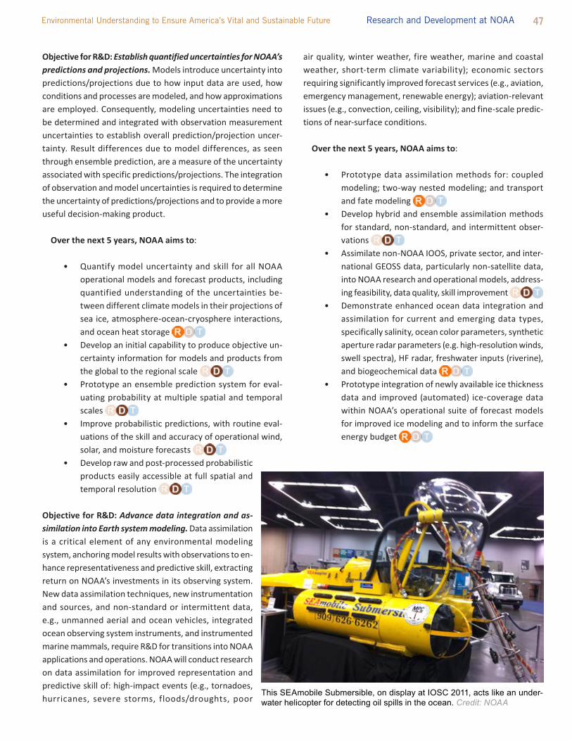
47 Environmental Understanding to Ensure America’s Vital and Sustainable Future Research and Development at NOAA
Objective for R&D: Establish quantified uncertainties for NOAA’s predictions and projections. Models introduce uncertainty into predictions/projections due to how input data are used, how conditions and processes are modeled, and how approximations are employed. Consequently, modeling uncertainties need to be determined and integrated with observation measurement uncertainties to establish overall prediction/projection uncer-tainty. Result differences due to model differences, as seen through ensemble prediction, are a measure of the uncertainty associated with specific predictions/projections. the integration of observation and model uncertainties is required to determine the uncertainty of predictions/projections and to provide a more useful decision-making product.
Over the next 5 years, NOAA aims to:
• Quantify model uncertainty and skill for all NOAA operational models and forecast products, including quantified understanding of the uncertainties be-tween different climate models in their projections of sea ice, atmosphere-ocean-cryosphere interactions, and ocean heat storage
• Develop an initial capability to produce objective un-certainty information for models and products from the global to the regional scale
• Prototype an ensemble prediction system for eval-uating probability at multiple spatial and temporal scales
• improve probabilistic predictions, with routine eval-uations of the skill and accuracy of operational wind, solar, and moisture forecasts
• Develop raw and post-processed probabilistic products easily accessible at full spatial and temporal resolution
Objective for R&D: Advance data integration and as-similation into Earth system modeling. Data assimilation is a critical element of any environmental modeling system, anchoring model results with observations to en-hance representativeness and predictive skill, extracting return on NOAA’s investments in its observing system. New data assimilation techniques, new instrumentation and sources, and non-standard or intermittent data, e.g., unmanned aerial and ocean vehicles, integrated ocean observing system instruments, and instrumented marine mammals, require R&D for transitions into NOAA applications and operations. NOAA will conduct research on data assimilation for improved representation and predictive skill of: high-impact events (e.g., tornadoes, hurricanes, severe storms, floods/droughts, poor
air quality, winter weather, fire weather, marine and coastal weather, short-term climate variability); economic sectors requiring significantly improved forecast services (e.g., aviation, emergency management, renewable energy); aviation-relevant issues (e.g., convection, ceiling, visibility); and fine-scale predic-tions of near-surface conditions.
Over the next 5 years, NOAA aims to:
• Prototype data assimilation methods for: coupled modeling; two-way nested modeling; and transport and fate modeling
• Develop hybrid and ensemble assimilation methods for standard, non-standard, and intermittent obser-vations
• Assimilate non-NOAA iOOS, private sector, and inter-national GEOSS data, particularly non-satellite data, into NOAA research and operational models, address-ing feasibility, data quality, skill improvement
• Demonstrate enhanced ocean data integration and assimilation for current and emerging data types, specifically salinity, ocean color parameters, synthetic aperture radar parameters (e.g. high-resolution winds, swell spectra), HF radar, freshwater inputs (riverine), and biogeochemical data
• Prototype integration of newly available ice thickness data and improved (automated) ice-coverage data within NOAA’s operational suite of forecast models for improved ice modeling and to inform the surface energy budget
This SEAmobile Submersible, on display at IOSC 2011, acts like an under-water helicopter for detecting oil spills in the ocean. Credit: NOAA
48 Five Year Research and Development Plan 2013-2017
Objective for R&D: Produce best-quality reference data. Many R&D activities require high-quality long-duration observation datasets. Quality, in part, is determined by how well the data represents the best understanding of the observations. improved information, understanding, and techniques for retrievals, calibration, sampling, and representation need to be applied to accumulated datasets via reprocessing and reanalysis to ensure that the data represents the best currently possible understanding of the observations.
Over the next 5 years, NOAA aims to:
• Reanalyze extended operational satellite observation records to generate calibrated and refined analysis of global and regional climate temperature, precipitation, and related ecosystem changes and trends
• Reanalyze operational model results, examining differ-ences for enhanced understanding of environmental processes and relationships
Key Question: What information technology developments can help NOAA improve quantitative predictions? Numerical prediction of Earth systems is computationally intensive, requiring large storage and access capacities, sufficient available high performance computing, and high-speed networking. Users demand real-time predictions and other products that rely on a robust, leading edge it infrastructure. NOAA’s environmental modeling enterprise must be positioned to develop modeling applications for research, the operational environment, and the transitions between them. Conse-quently, to leverage evolving commercial technology for innovative solutions, NOAA must invest in enabling these technologies for use in NOAA’s application systems.
Objective for R&D: Identify economical technology alternatives for computational effectiveness and efficiency. NOAA requires technology solutions, in addition to mission-focused R&D, to enable its science enterprise, particularly for its computationally and communications intensive components, such as numerical predictions. An important element of this objective is establish-ing a robust O2R high-performance computing environment.
Over the next 5 years, NOAA aims to:
• Evaluate fine-grained computing technologies within NOAA’s it architecture as a computing resource for running NOAA models
• Prototype, test, and assess cloud-computing tech-niques, demonstrating shipboard cloud-computing
IV. RELATIONSHIPS AMONg R&D EFFORTSMeeting these targets, achieving these objectives, and answering these key questions cannot be done by a single program, office, or agency. NOAA R&D demands cooperation and collaboration within the Agency and among partners. the sections below describe the unique needs of R&D per NOAA goal and enterprise objective, as well as the interdependencies among research efforts in these domains.
A. Dependencethere are many instances where addressing some questions and objectives in this plan requires the work to address other questions and objectives. Here, a few of the most important examples are highlighted by goal and enterprise objective. Also highlighted are the types of equipment, types of expertise, and types of information required for each, as well as specific internal and external partners, without whom the work could not be done.
ClimateClimate observations are required for research and modeling, which are then required for forecasts, predictions, and projections. A strong research foundation, along with a sustained observational network and modeling system, provides the basis for building scenarios and assessments of future conditions and of developing process-related understanding. Over time, research assessments will feed back information on how information on research and modeling capabilities is critically needed by society, such as assessing whether mitigation actions result in documented changes in greenhouse gasses. Moreover, findings from weather, ocean and coastal R&D will help define and refine the scales at which climate information is most useful in decision-making.
the Healthy Oceans goal depends on inputs such as climate observations, assessments, and training to incorporate climate considerations into fishery and protected resource decisions as well as iEA programs, while providing the Climate R&D with lMR-specific impacts of climate change. in order to make fisheries sustainable objective, we must increase our understanding of climate change and ocean acidification impacts on global and regional scales and manage our resources accordingly. the future of sustainable fisheries is very dependent on Climate R&D. Coastal R&D also relies on sea level magnitude and impacts information as it relates to observing, modeling research (integration of climate and coastal models to enable down-scaling and up-scaling of sea level and change predictions), training, and products. Climate R&D is also required for the regional climate services development and delivery system across sea level and ecosystems societal challenges, and the Sentinel Site Program.

49 Environmental Understanding to Ensure America’s Vital and Sustainable Future Research and Development at NOAA
Weatherthe goal of building a Weather Ready Nation is highly dependent on research that informs how the public consumes weather forecasts, warnings and information and applies it to actionable decisions. thus, while improvements to the accuracy of environmental data and predictive models are of fundamental importance to producing more reliable weather information, the improvement of the communication and use of that information is equally necessary to making our nation “weather ready.” Much of the technology development to make the nation weather ready is conducted at NOAA’s National Weather Service, building on, and transitioning into NWS operations the work of its NOAA (and other) research partners, especially NOAA’s Office of Oceanic and Atmospheric Research. R&D at NOAA’s National Environmental Satellite Data and information Service serves to improve remote sensing systems that yield meteorological observations. Advancing interactive and complex NOAA decision support services for public sector stakeholders must be based on a combination of social and behavioral research, real-world experience, test bed activities and proving ground demonstrations. Weather Ready Nation is critically dependent on a robust it infrastructure that can be quickly adapted to changing dissemination technologies, trends in social media, and new environmental forecast models.
Oceansto meet the R&D objectives for Healthy Oceans, NOAA programs rely on a diverse set of internal capabilities coupled with agreements with other Federal and state agencies, non-governmental and aca-demic programs, and marine businesses, users, and stakeholders. the future success of ecosystem-based management (EBM) will depend on a diverse and complex set of interconnected information sources, hardware managers, and data and model developers. R&D to integrate models supports the incorporation of data derived from a suite of vessels, buoys, satellites, and human observations. these models integrate a broad spectrum of observational data, from higher spatial resolution climate information, weather forecasts delivered at increasing rates, physical and chemical parameters in-corporated into biological data streams almost instantaneously, and socio-economic information looped as feedback into assessment outputs. Moreover, through data management R&D, data from these models is served to a multiplicity of users meeting diverse requirements and supporting a variety of temporal and spatial scales. in addition, R&D for Healthy Oceans is very dependent upon R&D that will improve regional climate predictions to understand climate-ecosystem interactions and their effect on ecosystem services. CoastsAs the current ecological forecasting portfolio increases its regional coverage for HABs forecasts to develop a nationwide capability and expands to include other topics, such as pathogen proliferation on beaches and in shellfish beds, there will be increased requirements for standardized and modular data integration, low-cost and high-throughput in situ monitoring systems, spatial coverage and skill assessment for modeling water and particle transport, and effective dissemination of information to resource managers and other stakeholders. the recently produced Ecological Forecasting Roadmap (September 2012) for enhanced development and delivery of a wide variety of ecological products and services at NOAA will be instrumental in setting priorities and achieving cost-efficiencies in developing new and enhanced forecasts for HABs, hypoxia, pathogens, sea level change impacts on coastal ecosystems and communities, and assessing impacts of land-based pollution on coastal ecosystems.
Stakeholder Engagementimproved engagement with NOAA’s stakeholders depends not on the natural sciences and engineering, but on the social and behavior-al sciences (to understand the actions and values of human beings), as well as on the arts and humanities (to craft communications and design media). For instance, the Climate Program Office within OAR needs such expertise to better understand the users of climate information, as well as their needs, to determine how and why they use (or don’t use) NOAA climate products, how decision makers
NOAA’s geostationary operational environmental satellite, or GOES, tracks heat waves by detecting cloud-free areas of the atmosphere that heat up quickly Credit: NOAA

50 Five Year Research and Development Plan 2013-2017
could better incorporate climate information into their resource management routines, and how NOAA could better convey climate forecasts and information to decision makers. in-house, federal and contract staff are the cornerstone of NOAA’s capacity in the social sciences, arts and humanities, but they are by no means the whole story. NOAA’s social science capacity also includes those outside the Agency who are supported by contracts and grants, partnerships, Cis, and inter-agency agreements.
Observing SystemsR&D in support of observing systems significantly depends on the requirements established by the R&D and operations supporting the Mission goals. this dependency focuses on what needs to be measured to support each goal, both operationally and for R&D. Much of this focus is on how to effectively and efficiently measure new types of observations, as well as how to improve the accuracy, coverage, resolution, effectiveness, and cost of measuring existing parameters. the analysis and modeling requirements of each mission goal drive R&D on optimizing the observing systems for analysis and predictive modeling. the focus of such R&D is on where, when, and with what fidelity to observe. NOAA’s observing system design depends on modeling for configuration optimization with respect to requirements, priorities, and resources. in turn, modeling research and operations depend on R&D quantifying observing system uncertainty.
Environmental ModelingEach goal and enterprise objective has a dependency on modeling R&D. As with R&D for NOAA’s observing system, R&D for environ-mental modeling depends on the requirements established by the Mission goals for analyses and projections/predictions. Environ-mental modeling ultimately depends on the R&D conducted in the interest of the goals for the science on underlying processes and relationships, critical elements necessary for establishing represen-tative modeling. improved representativeness, predictive skill, and the understanding and quantification of uncertainty depend on the R&D conducted in the interest of the goals and enterprise objective for improved, Reliable Data. the R&D of models, particularly those for operational application, drives R&D for capabilities such as model linking and coupling, nesting, and data assimilation.
B. interdependencethere is strong inter-dependence among NOAA’s R&D activities toward goals and enterprise objectives. the R&D conducted to answer one of the Key Questions in this document may depend critically on the answer to another Key Question. Many of these linkages are clearly understood; others may emerge as our science and technology advances.
the degree to which goal-based R&D is affected by cross-cutting functional R&D merits closer study. For example, weather forecasts and warnings are highly dependent on environmental data and numerical predictions – indeed, they could not be produced today without them. thus, the research to improve observing and modeling capabilities will have indirect benefits to the research to improve forecasts and warnings. Perhaps less obvious, however, is that NOAA’s research to improve the Nation’s weather readiness can also benefit greatly from the results of research to improve how the Agency engages stakeholders. For climate R&D we expect that the most spillover could come from R&D to integrate models. For oceans R&D, on the other hand, we believe it should come from R&D to improve observations. Moreover, R&D conducted in the interest of one goal may also indirectly benefit another goal. R&D for healthy oceans should have the most to gain from R&D conducted in the interest of other goals, whereas R&D for climate adaptation and mitigation will likely be most leveraged by the R&D for other goals.
C. Holistic UnderstandingAttention to the interdependence of NOAA’s varied R&D endeavors is also the key to the Agency’s premiere R&D objective: a holistic understanding of the Earth system. the R&D discussed in this plan will undoubtedly contribute to greater understanding of the Earth system; scientific activities always yield new knowledge, often leading future inquiries in unexpected directions. it should also contribute to an understanding that is more holistic.
in popular language, “holistic” simply means that the whole is more than the sum of its parts. in a scientific context, the word is a more specific reference to the perspective of general system theory,33 in which the properties of systems are distinguished from those of the components of systems. Systems’ properties are often “emergent,” that is, they cannot be deduced from knowledge of the properties of components. Understanding the Pacific Ocean, for example, is different from understanding water, fish, and boats. A more holistic understanding is, therefore, not a more fundamental understanding (i.e., reducing phenomena to smaller elements and general principles), nor a more precise understanding (i.e., increasing the detail with which we understand phenomena), nor is it a more comprehensive understanding (i.e., understanding more aspects of more elements of phenomena).
As an Earth science agency, NOAA contends with complex challenges that span many scientific and technical domains. the natural world does not abide by the distinctions that humans make among disciplines, organizations, nor even among the strategic goals, questions, and objectives outlined in this plan. in aiming for a holistic
33 Von Bertalanffy, ludwig (1950). “An outline of general system theory.” British Journal for the Philosophy of Science, Vol 1, pp.134-165. doi:10.1093/bjps/i.2.134

51 Environmental Understanding to Ensure America’s Vital and Sustainable Future Research and Development at NOAA
understanding of the Earth system, then, NOAA commits itself to integrating the diverse perspectives and professional expertise required by the Agency’s mission, and also to connecting the dots among otherwise separate R&D endeavors.
For NOAA’s ecosystem research, a holistic understanding demands that we study ecology as distinct from individual species and their habitats. For research on climate systems, it is the bridging of
phenomena at different spatial and temporal scales. For the devel-opment of observation systems, it is the architecture of interwoven technologies to collect and manipulate data. For the orchestration of NOAA’s entire innovation system, it is the translation of knowledge and technologies across the institutional boundaries of research and applications. in all these cases, we are connecting the dots, not collecting the dots.
Hydrothermal chimneys at Mata Ua, QUEST dive 328. The 2012 expedition aboard the R/V Revelle used the MARUM QUEST 4000 re-motely operated vehicle (ROV) investigating multiple sites on the northernmost spreading centers, magmatic arc and backarc regions of the northern Lau basin. Credit: NOAA

52 Five Year Research and Development Plan 2013-2017
SEc TION 3. PEOPLE, PL AcES, AND thingS – aSSetS SuPPoRting noaa’S R&D ENTERPRISE
Describing NOAA’s R&D strategy requires accounting not only for the objectives and targets, but for how they will be met. NOAA
R&D rests upon a foundation of indispensable assets. Successful implementation involves “soft” assets (i.e., people, institutions, and partnerships) as well as “hard” assets (i.e., data, models, computers, ships, planes, satellites, and buoys).
I. “SOFT” ASSETSNOAA’s laboratories, science centers, grant programs, and coop-erative agreements support leading-edge R&D. NOAA’s progress depends on the coordinated functioning of this vibrant scientific enterprise, drawing on a broad range of skills and capabilities. NOAA R&D requires the experience and expertise of a top-notch workforce that extends beyond the Agency itself. the talent of NOAA’s own bench scientists and engineers is complemented by extramural research partners, who provide additional expertise (for example, the social science and science extension expertise at Sea Grant institutions) and additional technologies (for example, the satellite launch vehicles provided by NASA).
A. Peoplethe most important component for NOAA R&D is the talent of its workforce. Focusing on environmental and social outcomes requires not only the best skills in the scientific and engineering disciplines, but also the best skills in interdisciplinary work. Understanding the natural, social, and economic systems that make up a dynamic ecosystem requires increased expertise in social and economic science as well as the physical sciences (Appendix C). As the R&D that NOAA conducts becomes more systems-oriented, the challenge becomes ensuring the right mix of talent and enabling diverse specialists on interdisciplinary teams. NOAA will continue to recruit outstanding professionals, balancing disciplinary, interdisciplinary, and managerial expertise, and cultivating existing and new sources of talent to evolve its workforce capabilities over time. Under current fiscal constraints and the pending wave of retirements, NOAA must address succession planning and strive to attract, hire, train, and retain a new generation of professionals to accomplish its strategic goals. this includes developing a scientific career track that does not require researchers to shift to management, but rather allows scientists to specialize in science and managers to specialize in management.
the scientists and engineers who conduct R&D for NOAA are not exclusively federal employees. in fact, a significant portion of those conducting NOAA R&D are from academic, private, or not-for-profit entities. Many are students, recent graduates, or volunteers
(Appendix C). A healthy innovation system needs to be comprised of a community of scientists across organizations, such that there is a constant flow of new ideas and coordination necessary to bring them to fruition. this balance requires strategic investment across professional specializations, ensuring that NOAA benefits from corporate knowledge, application of tactical skill sets, and innovative new ideas.
B. PlacesNOAA’s laboratories, science centers, programs, and Cis support or conduct research on Earth’s physical, chemical, and biological systems. NOAA has 50 organizational units that are responsible for either conducting or funding R&D. these include units such as the NESDiS Center for Satellite Applications and Research (StAR), the NMFS science centers, the NOS National Centers for Coastal Ocean Science (NCCOS), the NWS Office of Science and technology (OSt), the OAR Climate Program Office (CPO), the National Sea Grant Program, and the Earth System Research laboratory (ESRl). (A full list of R&D units with descriptions is provided in Appendix B.)
NOAA also funds research that is conducted by Cis, which are non-federal, non-profit research institutions in a long-term (5-10 year) collaborative partnership with NOAA. Many of the Cis are co-located with NOAA research laboratories, creating a strong, long-term collaboration between scientists in the laboratories and in the universities. the Ci program has been in existence for 44 years, with Cis located at parent institutions from Hawaii to Maine and from Alaska to Florida. Currently, NOAA supports 18 Cis consisting of 48 universities and research institutions across 21 states, Puerto Rico, and the U.S. Virgin islands. in FY 2011, NOAA provided $176.4M to Cis, supporting 1211 employees and 485 students.
NOAA’s National Sea Grant College Program is a national network of 33 university-based programs dedicated to serving citizens in coastal communities throughout the Nation. Sea Grant helps citizens understand, conserve, and better utilize America’s coastal, ocean, and Great lakes resources. With on-the-ground extension experts located in every coastal and Great lakes state, Sea Grant translates science, including results of research it funds, into services that benefit coastal residents and their communities, thus contributing to R&D at NOAA. Sea Grant has been in existence for 46 years. in FY 2011, NOAA provided $57.5M to 524 Sea Grant colleges or universities, supporting 2370 employees and 1882 students.
NOAA supports the R&D of other partners as well, such as the Educational Partnership Program (EPP), Cooperative Science Centers (CSCs) and the National Estuarine Research Reserves. in FY 2011, NOAA provided $76.5M to these partners, supporting 207 employees and 557 students. Further, NOAA awards other grants beyond Sea Grant. the total amount awarded for other R&D grant

53 Environmental Understanding to Ensure America’s Vital and Sustainable Future Research and Development at NOAA
solicitations in FY 2011 was $36.9M for 36 unique solicitations. the funding awarded in FY 2011 for grants selected in prior years’ solicitations was $76.37M. NOAA also supports partnership-ori-ented laboratories that are designed to enhance collaboration across NOAA and with other federal, academic and state partners. two examples are the Hollings Marine laboratory and the Oxford laboratory of NCCOS.
through its laboratories and programs, NOAA seeks to balance the activities that benefit from the long-term, dedicated capabilities of federal facilities with those that require the diverse expertise of our external partners. investment in capital equipment and moderniza-tion is critical to address the large research challenges inherent in NOAA’s mission and to support NOAA’s core competencies. At the same time, supporting our external partnerships provides for an infusion of ideas and nimbleness that is integral to NOAA’s mission. Maintaining this balance requires a constant assessment of NOAA’s R&D portfolio (see section 4) and targeting constrained resources. C. PartnersNOAA takes advantage of its broad national and international net-work of partners in other agencies, external academic institutions and professional societies, the private sector, non-profit organiza-tions, state, local, and tribal governments, and the international community.34 Extramural research partners complement NOAA’s intramural research by providing extended scientific, economic, and technical expertise and sources of new knowledge and technologies. NOAA’s research partners help maintain NOAA’s international leadership in environmental research. NOAA employs a variety of mechanisms to fund extramural research within appropriated fund-ing levels and congressional direction. these mechanisms include competitive, merit-based, peer-reviewed grants and cooperative agreements. NOAA announces the availability of grant funds for the upcoming fiscal year via a Federal Register notice.
II. “HARD” ASSETSthe knowledge produced by NOAA requires a solid base of integrat-ed observations, from which improvements in understanding are extracted and applied; consequently, NOAA’s observing systems serve as fundamental mission assets. Models and data assimilation systems are tools used to extract knowledge from observations to provide essential analyses and forecasts for decision support.
A. DataNOAA operations and R&D heavily rely on environmental data derived from observations. Data from NOAA’s and partner satellites, radars, manned and unmanned aircraft, ground stations, sea-going vessels, buoys, and submersibles are a critical foundational
34 National Oceanic and Atmospheric Administration. Research in NOAA: toward Understanding and Predicting Earth’s Environment. January 2008.
pillar for NOAA’s R&D. NOAA’s varied and growing requirements greatly exceed current capabilities, coverage, and/or resolution. in particular, biological observations are among the most challenging to collect, yet they represent a critical need. Much of the data used in NOAA R&D are collected by systems dedicated to NOAA’s regular operations (for example, the Geostationary Operational Environmental Satellite constellation and the tAO Array). Other data needs, however, are unique to R&D. NOAA’s observing system portfolio needs to balance growing demands for data with concerns about maintaining existing systems and implementing emerging technologies.35 Escalating costs to support existing and emerging observations require rigorous analysis and determination of the most effective observing portfolio.
Ensuring that environmental information is accessible and usable is as important as generating it to begin with. Standardized data management practices are required to organize data so that they can be effectively retrieved, preserved, analyzed, integrated into new data sets, and shared across communities and with the public. this includes practices for metadata and curation to make data accessible. the users of the data need to be able to understand the information, to compare and combine data from multiple observing systems, and to cite datasets for usage tracking and reproducible results.
B. ModelsModels represent how systems in the real world behave, employing integrated cause-and-effect relationships as characterized by principals, statistics, or empirical parameterization. Models provide the foundation for predictions of how the state of a system will evolve. Observational data provide the initial conditions for the modeled evolution and subsequently assimilated data constrain that evolution. in addition to producing operational forecasts, NOAA’s suite of models enable R&D to improve NOAA’s predictions of environmental conditions. Models improve and are improved by greater understanding of Earth system processes. Often, improving model performance requires including factors already captured by another model; thus, one of NOAA’s objectives is to more fully integrate Earth system models with each other, working with federal partners to establish standards for doing so. through modeling, NOAA can better understand changes and their implications, such as for the coastal and estuarine waters of the Great lakes, the effects of global climate change on hurricanes, the impacts of water use, and land-based pollution on marine ecosystems and human health. C. Computinginformation technology (it) is critical to NOAA R&D. Managing data, conducting analyses, and modeling environmental systems cannot
35 National Oceanic and Atmospheric Administration. Next Generation Strategic Plan. December 2010.

54 Five Year Research and Development Plan 2013-2017
occur without computing platforms, networks, data storage and information analytics. Modeling, in particular, relies on centralized, high-performance computing, but other approaches include cloud computing and virtualization. New high performance computing hardware architectures require scientific applications to run across multiple processors to achieve desired performance. improvements in modeling techniques have led to environmental models that can use many thousands of computer processors, which promises to dramatically increase both the accuracy and speed of producing environmental predictions.36
As consumer and professional use of social media sites becomes increasingly (and inextricably) intertwined, NOAA must have secure and flexible environments that stimulate participation by harnessing the power of collaboration tools and portals to promote innovation across NOAA line Offices and with partners. With the scale, scope, and geographic dispersal of NOAA’s various offices, NOAA’s it sup-ports unified communications by efficiently and reliably switching this traffic amongst formats, media and channels.
D. test Beds and Proving GroundsNOAA currently operates 11 test beds or proving grounds to accelerate the translation of R&D findings into better operations, services, and decision-making. NOAA’s test beds provide forums aimed at enhancing operational outputs and engaging researchers, operational scientists/experts, and partners in developing and testing in a quasi-operational framework.37 test bed outputs include demonstrated capabilities that advance NOAA’s mission needs and enhanced partnerships. Outcomes from a testbed are capabilities that have been shown to work with operational systems and could include more effective observing systems, better use of data in forecasts, improved forecast models, and applications for improved services and information with demonstrated economic/public safety benefits.
E. Facilities and Research PlatformsNOAA’s research infrastructure is comprised of a system of federal laboratories and science centers, as well as ships, aircraft, and other observing systems and platforms. this infrastructure is augmented through external partner assets. NOAA owns or leases hundreds of facilities across the U.S. and the world. Without these buildings, the equipment housed within them, the people who run them, not to mention everyday utilities such as electricity and water, little of the work outlined in this plan could take place. the construction, operations, and management activities required to maintain NOAA R&D are critical elements of the enterprise.
36 http://www.cio.noaa.gov/HPCC/pdfs/HPC_Strategic_Plan.pdf37 Guidelines for testbeds and proving grounds, 2011; http://www.testbeds.
noaa.gov/pdf/Recommmended%20Guidelines%20for%20NOAA%20test-beds%20and%20Operational%20Proving%20Grounds.pdf
Also critical are NOAA’s mobile research platforms: the wide variety of specialized aircraft and ships needed to complete NOAA’s environmental and scientific missions. NOAA’s ship fleet provides vessels for conducting NOAA’s hydrographic survey, oceanographic, atmospheric, and fisheries research activities. NOAA also operates a fleet of fixed-wing aircraft that collect environmental and geo-graphic data essential to, for example, hurricane and other weather and atmospheric research. to complement its research fleet, NOAA meets its ship and aircraft support needs through contracts with private sector and university partners.
NOAA Corps pilot Lt. Cmdr. Kristie Twining in the cockpit of a NOAA Twin Otter aircraft. Credit: NOAA
NOAA Sentinel watching over the coast. Credit: NOAA

55 Environmental Understanding to Ensure America’s Vital and Sustainable Future Research and Development at NOAA
SEcTION 4. A HEALTHy R&D ENTERPRISE
I. VALuESA healthy R&D enterprise means that the Agency directs innovation that has direct impact on the NOAA mission, funds those efforts to the degree that they can make a difference, and executes those efforts through an organization with the appropriate capabilities and expertise (oftentimes an external partner). Enterprise health also requires building upon existing best practices to promote scientific and technological excellence and to enable scientists and science leaders to pursue varied and valued R&D. NOAA is committed to ensuring its research is of demonstrable excellence, is responsive to societal needs, and provides the basis for new and more effective operational services and management actions.38 to achieve this, NOAA’s R&D enterprise rests on the following fundamental principles.
A. integrityFor science to be useful, it must be credible. NOAA’s research must be conducted with the utmost integrity and transparency. the recently established NOAA Administrative Order on Scientific integrity establishes a code of conduct for scientists and science managers to operate as a trusted source for environmental science. With this Order, NOAA has seized an opportunity to strengthen the confidence – of scientists, decision makers who depend on NOAA science, as well as the general public – in the quality and reliability of NOAA R&D.39
B. CollaborationNOAA requires the unique capabilities and expertise of its partners. the R&D required by NOAA’s mission cannot be conducted by the Agency alone. Extramural and cooperative research brings with it flexibility and diversity of capabilities. As noted in the 2004 SAB review of NOAA’s research enterprise, extramural research investment world class expertise not found in NOAA laboratories; enhanced connection to global science; leveraged external funding sources; multi-institutional coordination; access to external research facilities; and opportunities to engage with graduate and undergrad-uate students.40 Partners are necessary to help best articulate the needs and requirements driving the enterprise, but also to execute the research. Collaborative elements yield a wealth of innovation, serving to make NOAA’s research enterprise greater than the sum of its parts.
38 National Oceanic and Atmospheric Administration. Research in NOAA: toward Understanding and Predicting Earth’s Environment. January 2008.
39 http://www.corporateservices.noaa.gov/ames/administrative_orders/chapter_202/202-735-D.html
40 Science Advisory Board (2004). Review of the Organization and Management of Research in NOAA. A Report to the NOAA Science Advisory Board. the Research Review team.
C. integration
the crux of holistically understanding the Earth system is not only understanding its individual components, but understanding and interpreting the way each of the components interact and behave as an integrated composite that is more than the sum of its parts. Combining exploration, observations, process studies, modeling, and analysis can yield the improved understanding needed to ef-fectively predict and sustainably participate in this complex system. NOAA is committed to providing the discipline-specific foundation and the multi-disciplinary integration required to achieve and exploit holistic understanding of the Earth system in the interest of all four of its strategic goals.
D. innovationthe business community has long recognized the inherent importance of sustained investment in R&D to promote industrial excellence. General Electric CEO Jeff immelt, serving as the Chair of the President’s Council on Jobs and Competitiveness, has said “the mistake we make is by not making enough bets in markets that we’re experts in.”41 in the absence of such investment, services become stagnant and unresponsive to the constantly changing demands of the market. For a science-based agency, the argument is even more compelling; in place of market drivers, NOAA must remain responsive to the needs of the Nation, and do so in the face of challenges that cover a diversity of disciplines, time scales, and degrees of impact. innovation is “the implementation of a new or significantly improved product (good or service), or process, a new marketing method, or a new organizational method in business practices, workplace organization or external relations.”42 ideas and inventions are necessary for innovation, though alone they are not sufficient. innovation is the process of using ideas and inventions to create value.43 NOAA is committed to supporting innovation throughout its R&D enterprise to improve the understanding, products and services that support the Nation.
E. BalanceNOAA is committed to pursuing the breadth of R&D required to address the immediate needs of the Nation and the emerging chal-lenges of the future. As such, NOAA must maintain an appropriately balanced portfolio of activities (see Section 4.ii.A below for more details on portfolio management). it must balance the need for long-term outcomes with outcomes that are more immediate. it must also balance the R&D needs among its strategic goals and enterprise objectives. Further, NOAA’s R&D enterprise must be balanced with respect to demand for service and stewardship improvements (the
41 http://www.cbsnews.com/8301-504803_162-20117479-10391709.html42 Organisation for Economic Co-operation and Development (OECD), 2002.
Glossary of Key terms in Evaluations and Results Based Management. OECD Publications, Paris, France.
43 US Council on Competitiveness. (2005) Innovate America: National innovation initiative summit and report. Washington DC: US Council on Competitiveness.

56 Five Year Research and Development Plan 2013-2017
“pull”) with the new ideas that could revolutionize how goals are accomplished (the “push”).44
NOAA should strive for the appropriate balance of incremental, low-risk research investments with high-risk, high-reward initiatives (i.e., transformational research). indeed, part of NOAA’s scientific strength rests on its ability to encourage risk and, in doing so, tolerate failure. the Agency also needs to balance the potential of research directed by discrete, well-defined challenges with research that has objectives that are less well-defined. Often, the highest risk, most potentially transformative research is that which has the most tangible, time-bound objectives, such as the Apollo program in the 1960s aimed at “landing a man on the Moon and returning him safely to the Earth.” the right balance is often a judgment call, but we can have greater confidence in such judgments when they are informed by the knowledge of NOAA’s investments in these different dimensions of its R&D portfolio.
II. PORTFOLIO MANAgEMENT A strong R&D enterprise means building upon existing best practices to promote scientific and technological excellence and pursuing the R&D necessary to improve NOAA’s science, service, and stewardship responsibilities.
Strengthening science also means managing R&D effectively, which comprises actively planning, monitoring, evaluating, and reporting on the Agency’s R&D to ensure that the Nation obtains a sustained return on its investment aligned with NOAA’s strategic goals and objectives. Greater detail on this can be found in NOAA’s Administrative Order on Strengthening the R&D Enterprise. As with all other aspects of NOAA’s mission, R&D is conducted within NOAA’s SEE system. Strategy-based performance management, an iterative process of implementation planning, budgeting, execution, and evaluation, applies the evaluation results to subsequent planning, budgeting, and execution.
Strengthening R&D also encompasses coordinating across NOAA and with NOAA’s partners, exchanging information amongst scientists and clearly communicating the scope and value of NOAA’s R&D to others. A strong scientific enterprise, like any robust system, is determined not only by the quality of its components, but also the quality of their connections.
A. investment ChoicesR&D activities are investments in the future, and so we must assess tradeoffs among competing investment options in terms of focus, benefits, costs, and risks. Managing NOAA’s R&D enterprise requires
44 Science Advisory Board (2004). Review of the Organization and Management of Research in NOAA. A Report to the NOAA Science Advisory Board. the Research Review team.
that the Agency take a portfolio perspective. A portfolio is a set of investments that yield benefits and have costs and associated risks. Portfolio Management is the setting of policy on the distribution of investments across categories, based on expected results.
there are several obvious categorization schemes that NOAA can use to understand its portfolio: by strategic goal, by NOAA line Office, intramural versus extramural, and R&D as a proportion of all funding. Over the past few years, for example, non-federal partners have conducted between a quarter and a half of the R&D that NOAA funds. NOAA R&D represented 14% of the total appro-priation request budget in 2009, it rose to 17% in 2011, and declined to 13% in 2013.45 in comparison, other environmental agencies allocate a somewhat smaller proportion (for 2012, the Department of interior: 8%, Department of Agriculture: 10%, Environmental Protection Agency: 8%), other technology-heavy agencies allocate a much larger proportion (Department of Energy: 26%, National Aeronautics and Space Administration: 67%), and, the average for all non-defense agencies has stayed consistent at around 11% over the past few decades.46
Managing NOAA’s portfolio of R&D needs to take into account how the R&D activities address the breadth of NOAA’s responsibilities and fit together as a system of innovation; consequently, the set of
45 Data from NOAA Blue Books for FY 2010-2014. Available at: http://www.corporateservices.noaa.gov/nbo.
46 Other agency data applies to FY 2012. R&D budget data obtained from: http://www.aaas.org/spp/rd/fy2014/total14p.pdf and total apporpriated budget data obtained from: http://appropriations.house.gov/
Over the past few years, NOAA R&D has stayed between 12% and 17% of the total budget. Credit: NOAA

57 Environmental Understanding to Ensure America’s Vital and Sustainable Future Research and Development at NOAA
activities must be balanced across a number of dimensions beyond those discussed above. the table below provides some principal dimensions that are important to NOAA, and the types of choices enabled by each dimension, as developed by NOAA for the NOAA Science Advisory Board.47 there is no one option within these dimensions that is inherently better or worse; rather, NOAA aims for a balance along the continuum for each dimension, given the returns on investments that the Agency seeks.
Portfolio balancing is done with respect to NOAA’s strategy for R&D in pursuit of the objectives in NOAA’s strategic plan. Evaluating and confirming or setting dimensional balance targets for NOAA’s R&D portfolio are components of the strategic planning phase for NOAA’s R&D enterprise. Should NOAA be aiming for more radical or incremental innovation, near-term or longer-term results, or extramurally or internally conducted R&D? these questions require identifying what the current balances are and the expected costs and benefits of changing them. the answers depend upon which goals and objectives NOAA is trying to accomplish, and which take priority. Recent input from NOAA’s Science Advisory Board suggests that NOAA may need to reexamine the balance of its R&D portfolio in a few of these dimensions.48
One potential dimension for assessment is disciplinary specializa-tion, specifically with regard to the proportion of effort the Agency puts into social sciences compared with natural sciences and engi-
47 NOAA Science Advisory Board (2012). R&D Portfolio Review Task Force – Addi-tional Information, Available at: http://www.sab.noaa.gov/Working_Groups/current/SAB%20R&D%20PRtF%20Additional%20information%20Final%2005-09-12.pdf
48 While this R&D plan has been greatly informed by the SAB’s findings and recommendations, particularly those focused on NOAA’s R&D, this plan does not constitute the formal response from NOAA to the SAB, nor does this plan attempt to address the recommendations on NOAA’s organization and man-agement. NOAA encourages readers to review and comment on this plan in the context of the SAB’s report.
neering. Because people both affect, and are affected by the natural environment, NOAA must understand these interactions. Similarly, a move toward studying ecosystems (as distinct from the species and habitats that compose them) might require a research portfolio that is more inter- and trans-disciplinary than uni- or multi-dis-ciplinary.49 Another dimension in need of portfolio evaluation is output type, with regard to the proportion of attention and effort into activities of transition as compared with creation. “transition” is the transfer of knowledge or technology from a research or de-
velopment setting to a real-world setting. Surmounting the “valley of death” between research and applications is a challenge for many Federal agencies and NOAA is no exception
B. Planning R&DNOAA must continually strength-en the quality, relevance, and performance of its R&D products, balancing its portfolio of associ-ated R&D activities to optimally achieve NOAA’s strategic objec-tives. the purpose of R&D plan-ning is to establish objectives,
priorities, performance expectations, resource requirements, and the desired balance for R&D activities, thereby enabling consistent and coordinated management of these activities, both within and across organizational units.
Planning activities build a shared understanding of the purpose and direction for NOAA’s R&D enterprise. NOAA’s Science Advisory Board has found that “the major challenge for NOAA is connecting the pieces of its research program and ensuring research is linked to the broader science needs of the Agency.” And further, that “the overall research enterprise should be viewed as a corporate program. Explicit linkages between research efforts across organizational lines must be forged and maintained for the Agency and the nation to obtain the full benefit from research”.50 the planning process forges these necessary linkages.
49 “Multidisciplinarity draws on knowledge from different disciplines but stays within their boundaries. interdisciplinarity analyzes, synthesizes and harmonizes links between disciplines into a coordinated and coherent whole. transdisciplinarity integrates the natural, social and health sciences in a humanities context, and transcends their traditional boundaries.” Excerpt from: Choi, B. C., & Pak, A. W. (2006) ‘Multidisciplinarity, interdisciplinarity and transdisciplinarity in health research, services, education and policy: 1. Definitions, objectives, and evidence of effectiveness’, Clinical and investiga-tive Medicine. Médecine Clinique Et Experimentale, 29/6: 351-64
50 Science Advisory Board (2004). Review of the Organization and Management of Research in NOAA. A Report to the NOAA Science Advisory Board. the Research Review team.
Dimension choices
Strategy Goals and objectives from the NOAA strategic plan
time Horizon Short-term, mid-term, or long-term results
Risk level High, medium, or low chance of not achieving results
Degree of change incremental or radical results
Driver of change “Push” from research or “pull” from stakeholders
Comparative Advantage Activities unique to NOAA, or those that others can also conduct
Who Conducts internal or external, centralized or distributed
Specialized talent Natural science, social science, multi-, inter-, and trans-disciplinary
Output type Knowledge, technology, or transfer of knowledge/ technology
Table 2.Potential dimensions along which to balance an R&D portfolio

58 Five Year Research and Development Plan 2013-2017
Effective plans capture expected cause-and-effect relationships between desired outcomes and the investments that are required to achieve them, thus providing a structure for implementation, monitoring, and evaluation. NOAA’s R&D Plan can also serve as an important tool for communicating the importance and intended value of NOAA R&D to the Administration, the Department of Commerce, Congress, academia, regulated and user communities, and the public at large. in this capacity, this R&D plan serves to foster strategic partnerships with the external research commu-nity, whose valuable contributions are critical to meeting NOAA’s mission. this plan highlights NOAA’s R&D foci so that the external research community knows which research aligns with NOAA’s gaps and priorities. in so doing, it also establishes a framework of objectives and targets with which stakeholders can expect to have the results of monitoring and evaluation reported.
Planning for R&D should be appropriate for the kind of R&D being planned (see portfolio dimensions in the previous section). lower-risk, incremental advances may require a very sequential progress through a series of stage gates or technical readiness levels. More transformative advances might benefit less from a predefined set of hurdles than from multiple opportunities to iterate objectives with leadership and stakeholders as capabilities emerge from the work.51 All NOAA R&D, however, is directed, which means that it is guided by some objective that describes a vision of success.
C. Setting Priorities NOAA plans for R&D within the SEE cycle, within which NOAA man-ages performance. During the annual planning season, potential priorities permeate up from programs as options for line Office and Agency leadership to consider. leadership sets priorities at the corporate level, which then are translated to work plans at the program level. the NOAA Administrator states the Agency’s priorities in the Annual Guidance Memorandum (AGM) to focus the Agency’s attention on particular areas. implementation Plans (iPs) are then updated to detail how capabilities across the Agency are being used to satisfy those priorities, and how progress is expected to occur over the next few years.
Priorities are choices among options. Prioritizing something means performance in the priority area takes precedence over performance in other areas, resulting in difficult, but necessary decisions. Priorities are best framed as ends rather than means (i.e., requirements rather than solutions), so that programs have flexibility to pursue the best routes to achieve them. Priorities are established periodically by analyzing the strategic context for NOAA R&D, and how it may have changed. if the context has changed, if
51 Carleton, t. l. (2010). The value of vision in radical technological innovation. Dissertation, Stanford University Department of Mechanical Engineering.
NOAA is positioned to take action, and if this change warrants a change in strategic direction (including, but not limited to shifting investments), then priorities should change accordingly.
External changes often alter the context within which R&D is being conducted, for example: changes in science, technology, politics, budgets, economic outlook, environmental conditions, and evolving stakeholder needs. Changes can also be internal, for example: programmatic performance with respect to objectives. Context changes can be identified in several ways. internal changes can be identified through program evaluation (see next section), as well as less formal findings and recommendations of program staff. External changes can be identified by systematically scanning the media environment for emerging trends and issues, as well as simply engaging stakeholders and partners in active dialogue.
D. Evaluating R&DEvaluations of NOAA R&D inform NOAA on how well its R&D is progressing with respect to the R&D plan, and whether planning assumptions were valid. Evaluation begins with a logic model of how a program’s work is intended to result in strategic objectives.52 Based upon this model, NOAA can establish appropriate means of gauging performance as empirical means of assessing progress. NOAA policy on R&D assessment is consistent with the National Academies’ Best Practices, in which R&D is judged on three criteria: quality (scientific and technical merit of research as determined by peers), management (engagement with staff and stakeholders, as well as resource allocation and portfolio analysis), and impact (value of research results to people beyond the research community).53 With empirical data on these criteria (from internal and external sources), assessments can be made of process effectiveness and efficiency, of intended outcomes, of unintended impacts, and of benefits relative to costs. through evaluation, NOAA can learn if a program works the way it is intended; identify unknown causes of program outcomes and unanticipated consequences; and make bet-ter decisions about whether to continue, halt, or change a program.
Evaluation is the end and the beginning of NOAA’s performance management system. the findings and recommendations of R&D evaluation provide raw material with which to develop objectives and targets and set priorities, which, once established, are the basis of future evaluations. learning how to improve R&D involves asking questions such as: What R&D should be conducted to
52 Rogers, P. J., Petrosino, A., Huebner, t. A., and Hacsi, t. A. (2000). Program theory evaluation: Practice, promise, and problems. New Directions for Evaluation, 2000: 5-13.
53 National Research Council, Division on Engineering and Physical Sciences, laboratory Assessments Board, Panel for Review of Best Practices in Assess-ment of Research and Development Organizations (2012). “Best Practices in Assessment of Research and Development Organizations.” National Acad-emies Press, Washington, DC. Available at: http://www.nap.edu/catalog.php?record_id=13529.

59 Environmental Understanding to Ensure America’s Vital and Sustainable Future Research and Development at NOAA
achieve desired outcomes? is there sound logic connecting the R&D effort to the expected outcomes? is the design of the program or project optimal? What execution needs are there in terms of time and resources? Did the research conducted achieve the desired outcomes? Did the research conducted have any unexpected results or impacts?
NOAA values peer reviews of its laboratories/Centers, Programs, and Cis to ensure their quality, relevance and performance. National Sea Grant follows a rigorous review of all its state Sea Grant pro-grams. Formal policy establishes that peer review panels evaluate each lab every five years and prepare recommendations that labs must then address through implementation plans.54
NOAA’s program evaluation efforts are consistent with the perfor-mance management requirements of the Government Performance and Results Act (GPRA) and the 2010 GPRA Modernization Act, complying with, but not limited to, the performance management requirements of Congress and the Office of Management and Budget (OMB). NOAA meets or exceeds OMB rules for agencies to conduct peer review for Federal science according to established standards of quality, relevance, and scope set by the information Quality Act and Peer Review Bulletin.
54 http://www.corporateservices.noaa.gov/ames/administrative_orders/chapter_216/216-115.html
E. Engaging Stakeholders
NOAA’s capacity to achieve the objectives outlined in this plan de-pends on stakeholder engagement. Stakeholder engagement serves to identify user needs, from which NOAA’s R&D objectives and targets are ascertained. NOAA can effectively engage stakeholders by: strategically working with partners and the public; having two-way conversations to better identify society’s needs; and refining NOAA’s R&D to provide capabilities to meet those needs. NOAA’s next breakthrough in R&D may depend upon the unique knowledge or needs of a partner or customer. NOAA’s long-term success will be determined by its capacity to effectively engage individuals and other organizations. the most effective stakeholder engagement approach will depend on the situation, specific goals, objectives and desired outcome. in general, engaging stakeholders early and often leads to more successful partnerships and more valuable R&D. As a leader in oceanic and atmospheric R&D, but not the complete and sole source for these subjects, NOAA must work with others to meet the needs of society. Stakeholder engagement implies shared goals, objectives, and resources. implicit to engagement is listening, dialogue, understanding, and mutual support.
60 Five Year Research and Development Plan 2013-2017
SEcTION 5. APPENDIcES
APPENDIx A. MANDATES AND DRIVERS
America competes Act, 33 U.S.C. §§ 893, 893a, 893b – this Act contains provisions for what is commonly referred to as the NOAA education authority. these provisions authorize the establishment of a coordinated program (in consultation with the National Science Foundation (NSF) and the National Aeronautics and Space Admin-istration (NASA)) of ocean, coastal, Great lakes, and atmospheric R&D in collaboration with academic institutions and other non-gov-ernmental entities. in addition, these provisions authorize formal and informal educational activities to enhance public awareness and understanding.
Atlantic coastal Fisheries cooperative Management Act, (1993) 16 U.S.C. ‘’ 5101 – 5108; DOO-10-15 Section 3.01(nn). the Atlantic Coastal Fisheries Cooperative Management Act (ACFCMA or the Atlantic Coastal Act) provides for a cooperative state and Federal management regime designed to support the interstate coastal fisheries management efforts of the Atlantic States Marine Fisheries Commission (ASMFC or the Commission). this regime is based on Congress’s finding that primary management responsibilities rest with the states, via the Commission, and that the Federal govern-ment should serve in a supportive role.
Atlantic Tunas convention Act, 16 U.S.C. §§ 971 et seq. – the Act is the implementing statute for the international Convention for the Conservation of Atlantic tunas (iCCAt), to which the United States is a party. iCCAt is a regional fishery management organization that manages and conserves bluefin tuna, swordfish, and other tuna and tuna-like species in the Atlantic Ocean. the Act authorizes the Secretary of State, with the concurrence of the Secretary of Commerce (and for enforcement matters, the Secretary of the department in which the Coast Guard is operating), to take action in response to recommendations from the Commission. 16 U.S.C. § 971d; see also 16 U.S.C. § 971c(a).
clean Air Act (42 U.S.C. § 7401) requires that NOAA identify and assess the extent of deposition of atmospheric pollutants to the Great lakes and coastal waters; and conduct research, in conjunction with other agencies, to improve understanding of the short-term and long-term causes, effects, and trends of damage from air pollutants on ecosystems.
clean Water Act. 33 U.S.C. ‘ 1311. the Clean Water Act (CWA) is the principal statute governing water quality. the Act’s goal is to restore and maintain the chemical, physical, and biological integrity of the Nation’s waters. the CWA regulates both the direct and indirect discharge of pollutants into the Nation’s waters. Section 301 of the
Act () prohibits the discharge into navigable waters of any pollutant by any person from a point source unless it is in compliance with a National Pollution Discharge Elimination System (NPDES) permit. Section 311 of the CWA (33 U.S.C. ‘ 1321) regulates the discharge of oil and other hazardous substances into navigable waters and waters of the contiguous zone, as well as onto adjoining shorelines, that may be harmful to the public or to natural resources (CWA section 311(b)(1)). the Act allows the Federal government to remove the substance and assess the removal costs against the responsible party (CWA section 311(c)). the CWA defines removal costs to include costs for the restoration or replacement of natural resources damaged or destroyed as a result of a discharge of oil or a hazardous substance (CWA section 311(f)(4)).
consumer Option for an Alternative System To Allocate Losses Act of 2011 or cOASTAL Act of 2011 will lower costs to the National Flood insurance Program by better discerning wind versus storm surge damages in the case of “clean slabs,” where little tangible evidence beyond a building’s foundation remains for the proper adjustment of insurance claims for homes totally destroyed by a hurricane or tropical storm, and will enable a more timely claims adjustment process which has frequently faced excessive delays due to litigation between the Federal government and private insurers, resulting from an inability to determine to what extent the damage should be covered by the National Flood insurance Program or by private insurers covering wind damage. Under the new law,NOAA is required to produce detailed post-storm analyses (hind-cast models) following named storms that impact the coastal zone of the U.S. these analyses are then required to be submitted to the Department of Homeland Security, Federal Emergency Management Agency (DHS/FEMA) within 90 days. NOAA is required to make all data and post-storm assessments available to the public and to maintain an online database. the database and post-storm model are mandated to be operational by Dec. 28, 2013 (540 days after enactment).
coast and geodetic Survey Act, 33 U.S.C. §§ 883a et seq. – this Act provides the basis for NOAA’s navigation service programs. the Act authorizes the Secretary to conduct hydrographic and topographic surveys, tide and current observations, and geodetic-control surveys, geomagnetic, seismological, gravity and related geophysical measurements to provide: (1) charts and other information for safe marine navigation; and (2) basic data for engineering and scientific purposes and for other commercial and industrial need. 33 U.S.C. §§ 883a, 883b. the Act establishes NOAA as the depository for geo-magnetic data, 33 U.S.C. § 883c, and authorizes NOAA to establish national standards for hydrographic data and assure that such data is available in a uniform and easily accessible format, 33 U.S.C. § 892. coastal Ocean Program (201(c) of PL 102-567): the National Oceanic and Atmospheric Administration Reauthorization Act authorizes a Coastal Ocean Program, and is therefore basic authorizing legislation

61 Environmental Understanding to Ensure America’s Vital and Sustainable Future Research and Development at NOAA
for NCCOS. in the words of the law: “Such program shall augment and integrate existing programs of the National Oceanic and Atmospheric Administration and shall include efforts to improve predictions of fish stocks, to better conserve and manage living marine resources, to improve predictions of coastal ocean pollution to help correct and prevent degradation of the ocean environment, to promote development of ocean technology to support the effort of science to understand and characterize the role oceans play in global climate and environmental analysis, and to improve predictions of coastal hazards to protect human life and personal property.”
coastal Wetlands Planning, Protection, and Restoration Act, 16 U.S.C. ‘’ 3951-3956; DOO-10-15 Section 3.01(dd). this Act creates a louisiana Coastal Wetlands Conservation and Restoration task Force, with the Secretary of the Army as its chairman and the Secretary of Commerce (among others) as a member. the Secretary of the Army is required to convene meetings of the task Force to ensure that it produces a list of coastal wetlands restoration projects in louisiana, to provide for long-term conservation of such wetlands and dependent fish and wildlife populations. the task Force is required to prepare a plan to identify coastal wetlands restoration projects, to develop a comprehensive approach to restore, and prevent loss of, coastal wetlands in louisiana.
coastal Zone Management Act. the goal of the Coastal Zone Management Act (CZMA) is to encourage states to preserve, protect, develop and, where possible, restore and enhance valuable natural coastal resources. Participation by states is voluntary. to encourage states to participate, the Federal government, through the Secretary of Commerce (Secretary), may provide grants to states that are willing to develop and implement a comprehensive coastal management program (CZMA, section 306). thirty-four coastal and Great lakes states have a Federally approved program. this represents 99% of the nation’s 95,331 miles of ocean and Great lakes coastline. illinois is the only potentially eligible state that does not yet have an approved program, and illinois is currently working towards approval. the CZMA also authorizes the National Estuarine Research Reserve System. Under the CZMA, the Secretary may make grants, not to exceed 50% of the cost of the project, which enable coastal states to acquire, develop, and operate estuarine research reserves (CZMA, section 315). Designation of an estuarine reserve requires a state to agree to long-term management of the site for research purposes, and to provide information for use by coastal zone managers.
commerce and Trade, 21 15 U.S.C. § 1511 “Sec. 2901. Findings. the following are hereby transferred to the Secretary of Commerce: (e) those functions vested in the Secretary of Defense or in any officer, employee, or organizational entity of the Department of Defense
by the provision of Public law 91- 144, 83 Stat. 326, under the heading` .̀.. (2) the conception, planning, and conduct of basic R&D in the fields of water motion, water characteristics, water quantity, and ice and snow, and (3) the publication of data and the results of research projects in forms useful to the Corps of Engineers and the public, and the operation of a Regional Data Center for the collection, coordination, analysis, and the furnishing to interested agencies of data relating to water resources of the Great lakes.”
comprehensive Environmental Response, compensation, and Liability Act (cERcLA), 42 U.S.C. ‘ 9601 et seq., Pub. l. No. 96-510, (1980) as amended by the Superfund Amendments and Reauthori-zation Act (SARA) Pub. l. No. 99-499; DOO-10-15 Section 3.01mm. CERClA establishes the Federal government’s authority to respond to releases or threatened releases of hazardous substances into the environment. it establishes the legal framework for ensuring the comprehensive cleanup of contaminants released to the environment as the result of past actions or current spills. Primary responsibility for enforcing the act rests with the Environmental Protection Agency (EPA). CERClA section 120, entitled “Federal Facilities,” describes the applicability of CERClA to Federal facilities. Under section 120, United States Government agencies and depart-ments must remediate environmental hazards to the same extent as other, non-governmental entities. CERClA 120 also serves to provide for the expedient identification of uncontaminated government properties to ensure their timely transfer to the private sector for development. this portion of the Act is considered a statute of general applicability to NOAA.
coral Reef conservation Act, 16 u.S.c. 6401. the purposes of this title are (1) to preserve, sustain, and restore the condition of coral reef ecosystems; (2) to promote the wise management and sustainable use of coral reef ecosystems to benefit local commu-nities and the Nation; (3) to develop sound scientific information on the condition of coral reef ecosystems and the threats to such ecosystems; (4) to assist in the preservation of coral reefs by supporting conservation programs, including projects that involve affected local communities and nongovernmental organizations; (5) to provide financial resources for those programs and projects; and (6) to establish a formal mechanism for collecting and allocating monetary donations from the private sector to be used for coral reef conservation projects.
Data Quality Act (a.k.a. information Quality Act) P.l 106-554. Section 515 of the treasury and General Government Appropriations Act for Fiscal Year 2001 Section 515,directs the Office of Management and Budget (OMB) to issue government‑wide guidelines that provide policy and procedural guidance to federal agencies for ensuring and maximizing the quality, objectivity, utility, and integrity of information (including statistical information) disseminated by

62 Five Year Research and Development Plan 2013-2017
federal agencies.OMB complied by issuing guidelines which direct each federal agency to: (A) issue its own guidelines ensuring and maximizing the quality, objectivity, utility, and integrity of infor-mation disseminated by the agency; (B) establish administrative mechanisms allowing affected persons to seek and obtain correction of information that does not comply with the OMB 515 Guidelines (Federal Register: February 22, 2002, Volume 67, Number 36, pp. 8452‑8460, herein OMB Guidelines or the agency guidelines; and (C) report periodically to the Director of OMB on the number and nature of complaints received by the agency regarding the accuracy of information disseminated by the agency and how such complaints were handled by the agency.
Endangered Species Act. the Endangered Species Act (ESA) imposes a number of mandatory duties on the Secretaries of Commerce and the interior. Section 4(a)(2) of the statute provides that the Secretary of Commerce generally exercises these responsibilities for most marine and anadromous species and the Secretary of the interior for land-based and freshwater species, pursuant to Reorganization Plan No. 4 of 1970 that created NOAA. 16 U.S.C. 1533(a)(2). in 1974, the Directors of the U.S. Fish and Wildlife Services and the National Marine Fisheries Service signed a Memorandum of Understanding that clarified responsibilities based on scientific division of species, but leaving the same general division of responsibilities between the Services intact. Memorandum of Understanding Between the U.S. Fish and Wildlife Service, United States Department of the interior, and the National Marine Fisheries Service, National Oceanic and Atmospheric Administration, United States Department of Commerce, Regarding Jurisdictional Responsibilities and listing Procedures Under the Endangered Species Act of 1973 (August 28, 1974). For certain species, including sea turtles and Atlantic salmon, the Services subsequently agreed to exercise joint responsibility. Memorandum of Understanding Defining the Roles of the U.S. Fish and Wildlife Service and the National Marine Fisheries Service in Joint Administration of the Endangered Species Act of 1973 as to Marine turtles (July 18, 1977); Memorandum of Agreement Between the Northeast Region, U.S. Fish and Wildlife Service and the Northeast Region, National Marine Fisheries Service, Concerning the Anadromous Atlantic Salmon (March 14, 1994).
Establishment of great Lakes Research Office, 33 U.S.C. § 1268: there is established within the National Oceanic and Atmospheric Administration the Great lakes Research Office. the Research Office shall conduct, through the Great lakes Environmental Research laboratory, the National Sea Grant College program, other Federal laboratories, and the private sector, appropriate research and monitoring activities which address priority issues and current needs relating to the Great lakes.
Estuary Restoration Act of 2000, 33 U.S.C. ‘’ 2901-2909.this Act establishes an estuary habitat restoration program under which the Secretary of the Army (Corps of Engineers) may carry out estuary habitat restoration projects and provide technical assistance. the restoration projects must be originated by non-Federal interests and require non-Federal match (Federal share cannot exceed 65%). the Secretary of the Army selects the projects, but must select projects from a list of proposals submitted by the Estuary Habitat Restoration Council. 33 U.S.C. ‘ 2903.
Federal Insecticide, Fungicide, and Rodenticide Act, 7 U.S.C. ‘ 136 et seq.the Federal insecticide, Fungicide, and Rodenticide Act (FiFRA) is primarily implemented by 40 C.F.R. ‘’ 152-186. the Act and its implementing regulations are designed to manage the development, storage, application, and disposal of pesticides. the Act is a statute of general applicability to NOAA, and the disposal regulations are of most relevance to NOAA.
Federal Ocean Acidification Research and Monitoring Act of 2009, 33 U.S.C. §§ 3701 – 3708 – the Act provides authority to establish and maintain an ocean acidification program to include conducting interdisciplinary and coordinated research and long-term monitoring of ocean acidification. the Secretary of Commerce is directed to establish and maintain an ocean acidification program to include conducting interdisciplinary and coordinated research and long-term monitoring of ocean acidification. the Secretary of Commerce may enter into and perform such contracts, leases, grants or cooperative agreements as may be necessary.
Fish and Wildlife coordination Act, (1934) 16 U.S.C. ‘661-666c; Pub. l. No. 85-624. the purpose of the Act is to ensure that wildlife conservation receives equal consideration, and be coordinated with, other aspects of water resources development. the Act requires Federal departments and agencies that undertake an action, or issue a Federal permit or license that proposes to modify any stream or other body of water, for any purpose including navigation and drainage, to first consult with the U.S. Fish and Wildlife Service, Department of the interior; the National Marine Fisheries Service (NMFS), Department of Commerce; and appropriate state fish and wildlife agencies. the Federal and state resource agencies provide recommendations and comments to the Federal action agency that should provide for the conservation of fish and wildlife resources by preventing loss of or damage to the resources. the action agency then must give equal consideration to the conservation of fish and wildlife resources in making water resource development decisions. the Department of the interior, NMFS and state agencies may develop reports that determine the possible damage to fish and wildlife resources and recommend means and measures that should be adopted to prevent the loss of or damage to fish and wildlife resources while allowing for the development and improvement
63 Environmental Understanding to Ensure America’s Vital and Sustainable Future Research and Development at NOAA
of such water resources. Agencies shall include in any reports to Congress supporting a recommendation for authorization of any new project an estimate of the wildlife benefits or losses expected from the project.
geophysical Sciences Authorities, 33 U.S.C. §§ 883d, 883e – these provisions authorize the Secretary to conduct surveys, research, and investigations in geophysical sciences. in order to improve efficiency and increase engineering and scientific knowledge, the Secretary of Commerce is authorized to conduct developmental work for improvement of surveying and cartographic methods, instruments, and equipment; and to conduct investigations/research in geophys-ical sciences (including geodesy, oceanography, seismology, and geomagnetism.). 33 U.S.C. § 883d. the Secretary of Commerce is further authorized to enter into cooperative agreements with, and to receive and expend funds made available by State or Federal agency, as well as any public or private organization or individual for purposes of surveying or mapping activities, including special purpose maps. 33 U.S.C. § 883e.
global change Research Act, 15 U.S.C. §§ 2921 et seq. – the Act establishes a comprehensive and integrated U.S. research program aimed at understanding climate variability and its predictability. the Secretary of Commerce shall ensure that relevant research activities of the National Climate Program are considered in developing national global change research efforts.
Harmful Algal Bloom and Hypoxia Research and control Act of 1998, , 33 U.S.C. § 145: the National Oceanic and Atmospheric Administration, through its ongoing research, education, grant, and coastal resource management programs, possesses a full range of capabilities necessary to support a near and long-term compre-hensive effort to prevent, reduce, and control HABs and hypoxia; funding for the research and related programs of the National Oceanic and Atmospheric Administration will aid in improving the Nation’s understanding and capabilities for addressing the human and environmental costs associated with HABs and hypoxia.
High-Performance computing and communication Act of 1991: “NOAA shall conduct basic and applied research in weather predic-tion and ocean sciences, particularly in development of new forecast models, in computational fluid dynamics, and in the incorporation of evolving computer architectures and networks into the systems that carry out Agency missions.”
Integrated coastal and Ocean Observation System (IcOOS) Act of 2009, 33 U.S.C. §3601-3610. this act establishes a national integrated System of ocean, coastal, and Great lakes observing systems, comprised of Federal and non-Federal components including in situ, remote, and other coastal and ocean observation,
technologies, and data management and communication systems. the System is designed to address regional and national needs for ocean information; to gather specific data on key coastal, ocean, and Great lakes variables; and to ensure timely and sustained dissemination and availability of these data to support a variety of societal benefits. these benefits include supporting national defense; marine commerce; navigation safety; weather, climate, and marine forecasting; energy siting and production; economic development; ecosystem-based management of marine and coastal areas; conservation of ocean and coastal resources; and public safety. the System is also designed to promote research to develop, test, and deploy innovations and improvements in coastal and ocean observation technologies and modeling systems.
Magnuson-Stevens Fishery conservation & Management Act (MSA), 16 U.S.C. §§ 1801 et seq. – the MSA establishes exclusive Federal management authority over fishery resources of the U.S. Exclusive Economic Zone (EEZ) and requires, among other things, rebuilding of overfished stocks of fish and preventing overfishing while maintaining, on a continuing basis, optimum yield from fisheries. 16 U.S.C. § 303(a). Most fishery management plans (FMPs) are developed by regional fishery management councils and must comply with ten National Standards, 16 U.S.C. §§ 1851(a), 1852. the Secretary is responsible for reviewing and implementing FMPs through regulations. 16 U.S.C. § 1854.
Marine Debris Research, Prevention, and Reduction Act, 33 U.S.C. 1951 note; Pub. l. No. 109-449.this Act establishes within the National Oceanic and Atmospheric Administration (NOAA) a Marine Debris Prevention and Removal Program to reduce and prevent the occurrence and adverse impacts of marine debris on the marine environment and navigation safety. Requires the Administrator of NOAA (Administrator), subject to the availability of appropriations, to: (1) undertake marine debris mapping, impact assessment, prevention, and removal efforts, with a focus on marine debris posing a threat to living marine resources and navigation safety; (2) improve efforts to reduce adverse impacts of lost and discarded fishing gear on living marine resources and navigation safety; (3) undertake outreach and education of the public and other stakeholders in the fishing, fishing gear manufacturers, other marine-dependent, and plastic and waste management industries, on sources of, and threats associated with, marine debris and approaches to identify, determine sources of, assess, reduce, and prevent such debris and its adverse impacts on the marine environment and navigational safety; and (4) develop and promulgate, jointly with the Coast Guard, a definition of the term “marine debris” for the purposes of this Act.
Marine Mammal Protection Act. the Marine Mammal Protection Act (MMPA) was enacted to protect certain species and stocks of

64 Five Year Research and Development Plan 2013-2017
marine mammals and to achieve healthy populations of marine mammals. Pursuant to the MMPA, the Secretary of Commerce (Secretary) maintains jurisdiction over cetaceans (whales, dolphins, and porpoises) and pinnipeds (seals and sea lions). the Secretary of the interior maintains jurisdiction over all other marine mammals, e.g., polar bears, walrus, and manatee. the MMPA generally pro-hibits taking and importation of all marine mammals, except under limited exceptions. these exceptions include, but are not limited to, the following: (1) taking incidental to specified activities such as construction projects, military activities, or oil and gas development; (2) taking incidental to commercial fishing operations; (3) taking by Federal, State or local government official duties; and (4) the intentional lethal taking of individually identifiable pinnipeds which are having a significant negative impact on the decline or recovery of at-risk salmonids. in addition, the Secretary may issue permits to authorize the taking or importation of any marine mammal as part of scientific research, public display, or to enhance the survival or recovery of a species or stock (MMPA ‘ 1374).
Meteorological Services to Support Aviation Authority, 49 U.S.C. § 44720 – this provision of the Federal Aviation Act of 1958 requires the Secretary of Commerce to cooperate with the FAA in providing meteorological services necessary for the safe and efficient movement of aircraft in air commerce; i.e., to support aviation. the Secretary of Commerce is required to observe and study atmospheric phenomena, and maintain meteorological stations and offices; provide reports that will facilitate safety in air navigation; cooperate with those engaged in air commerce and in meteorological services; maintain and coordinate international exchanges of meteorological information; participate in developing an international basic meteorological reporting network; coordinate meteorological requirements in the U.S. to maintain standards and promote safety and efficiency of air navigation; and promote and develop meteorological science, including support for research projects in meteorology.
Migratory Bird conservation Act, 126 u.S.c. 715 et seq.
National Aquaculture Act, 16 U.S.C. ‘ 2801-2810; DOO-10-15 Section 3.01(jj) the Secretaries of Agriculture, Commerce and the interior (Secretaries) shall establish a National Aquaculture Development Plan, (Plan) in consultation with appropriate Federal officers, States, Regional Fishery Management Councils and the aquaculture industry, that shall, inter alia identify aquatic species which have potential for culturing, recommend actions necessary to achieve such potential and specify time frames for completion of actions and which department has responsibility for implementation of each action. the Secretaries shall maintain a continuing assessment of aquaculture in the United States.
National climate Program Act, 15 U.S.C. §§ 2901-2908 – the Act authorizes a National Climate Program. the Act grants NOAA the authority to enter into contracts, grants or cooperative agreements for climate-related activities. these activities include assessments of the effect of climate on the natural environment, land and water resources and national security; basic and applied research to improve understanding of climate processes and climate change; methods for improving climate forecasts; global data collection and monitoring and analysis activities; systems for management and dissemination of climatological data; measures for increasing international cooperation in climate research, monitoring, anal-ysis and data dissemination; mechanisms for intergovernmental climate-related studies and services including participation by universities; and experimental climate forecast centers.
National coastal Monitoring Act (Title V of 33 uSc 2801-2805): the Act requires the Administrator of the Environmental Protection Agency and the NOAA Under Secretary, in conjunction with other federal, state and local authorities, jointly to develop and implement a program for the long-term collection, assimilation, and analysis of scientific data designed to measure the environmental quality of the nation’s coastal ecosystems.
National Marine Sanctuaries Act. 16 U.S.C. ‘ 1433. the National Marine Sanctuaries Act (NMSA) provides the Secretary of Commerce with the authority to protect and manage the resources of significant marine areas of the United States. NOAA’s administration of the marine sanctuary program involves designating marine sanctuaries and adopting management practices to protect the conservation, recreational, ecological, educational, and aesthetic values of these areas.
the NMSA states that the Secretary of Commerce may designate any discrete area of the marine environment as a national marine sanc-tuary and promulgate regulations implementing the designation, if the Secretary determines the designation will fulfill the purposes of the Act and the designation meets certain criteria. the Act spells out factors for the Secretary to consider in making a designation, and requires consultation with Congress. the Secretary is required to evaluate periodically the implementation of each sanctuary’s management plan and goals for the sanctuary. the Secretary is required to conduct research monitoring, evaluation, and education programs as are necessary and reasonable to carry out the purposes and policies of the NMSA. the Act states the Secretary may establish advisory councils to provide assistance regarding the designation and management of national marine sanctuaries.
National Sea grant college Program Act, 33 U.S.C. §§ 1121-1131 – the Act establishes a comprehensive NOAA Sea Grant Program, run by NOAA’s Office of Oceanic and Atmospheric Research (OAR).

65 Environmental Understanding to Ensure America’s Vital and Sustainable Future Research and Development at NOAA
the Act provides that the Secretary of Commerce shall establish a National Sea Grant College Program that shall consist of the financial assistance and other authorized activities that provide support for the elements of the program, including in support of solving coastal problems and developing marine resources. the Secretary of Commerce may make grants and enter into contracts under this Act to assist any sea grant program or project if the Secretary finds that such program or project will implement the objective of the Act and be responsive to the needs or problems of individual states or regions.
Nonindigenous Aquatic Nuisance Prevention and control Act of 1990 and National Invasive Species Act of 1996, 16 U.S.C. ‘’ 4701-4751; DOO-10-15 Section 3.03f. these Acts are intended to manage the adverse impacts of aquatic nuisance species (ANS) by preventing their unintentional introduction and dispersal into the waters of the United States through ships ballast water and other means. they also provide for the management of those ANS which have already become established and for research and development. the Nonindigenous Aquatic Nuisance Prevention and Control Act establishes an interagency Aquatic Nuisance Species task Force. the Under Secretary of Commerce for Oceans and Atmosphere is mandated to serve as the co-chairperson of this task Force. the task Force, in general, is required to develop and implement a program for U.S. waters to prevent the introduction and dispersal of ANS; to monitor, control, and study such species; and to disseminate related information. the Under Secretary is authorized to issue rules and regulations as are necessary for accomplishing the objectives of the task Force.
the task Force is required to allocate funds for competitive research grants to study all aspects of ANS. this grant program shall be administered through the National Sea Grant College Program and the Cooperative Fishery and Wildlife Research Units; however, to date, it has been administered exclusively by Sea Grant. the task Force is also required to: (1) establish and implement educational programs through Sea Grant Marine Advisory Services and any other available resources as it determines necessary to inform the public; and (2) make available $1,625,000 from funds that are otherwise authorized, if they are so authorized, to fund ANS research at NOAA’s Great lakes Environmental Research laboratory, including $500,000 for research relating to lake Champlain. Subject to appropriations, the Secretaries of interior and Commerce are required to conduct a ballast water management demonstration program to demonstrate technologies and practices to prevent ANS from being introduced through ships ballast water.
NOAA undersea Research Program Act of 2009, 33 U.S.C. §§ 3421-3426 – the Act authorizes a comprehensive NOAA Undersea Research Program. Activities authorized under these provisions
include core research and exploration based on national and re-gional undersea research priorities; advanced undersea technology development to support NOAA’s research mission and programs; undersea science-based education and outreach programs to enrich ocean science education and public awareness; development, test-ing, and transition of advanced undersea technology; and discovery, study and development of natural resources and products from ocean, coastal, and aquatic systems.
Ocean Exploration Program Act, 33 U.S.C. §§ 3401-3406 – these provisions establish a comprehensive and coordinated National Ocean Exploration Program. Activities authorized under these provisions include giving priority attention to deep ocean regions, conducting scientific voyages to locate, define and document historic shipwrecks and submerged sites, enhancing the technical capability of the U.S. marine science community and establishing an ocean exploration forum to encourage partnerships and promote communication among experts to enhance the scientific and technical expertise and relevance of the National Ocean Exploration Program. these activities are further highlighted in Public law 111–11 of 2009.
Ocean Dumping Act (Titles I and II of the Marine Protection, Research and Sanctuaries Act), 33 U.S.C. ‘’ 1401-1445. the Marine Protection, Research, and Sanctuaries Act (MPRSA) provides for the regulation of dumping and transportation for dumping of material, into the territorial sea of the United States, or into a zone contiguous to the territorial sea of the U.S., extending to a line twelve nautical miles seaward from the base line from which the breadth of the ter-ritorial sea is measured. 33 U.S.C. ‘’ 1411. EPA shares responsibility for administration with the U.S. Army Corps of Engineers, which regulates dumping of dredged material, and the U.S. Coast Guard, which has responsibility for surveillance and other enforcement activities to prevent unlawful dumping. Id. at ‘’ 1413, 1417.
title ii of the Act establishes a comprehensive and continuing monitoring and research program, required to be undertaken by the Secretary of Commerce, in coordination with EPA and the Coast Guard, on the effects of dumping into ocean waters, coastal waters or waters of the Great lakes and their connecting waters. Id. at ‘ 1441. the Secretary shall initiate this program in close consultation with appropriate federal agencies. Responsibilities of the research program shall include the long-range effects of pollution, overfish-ing, and man-induced changes in the environment. this program shall take into account such factors as international policies, economic considerations, alternatives to existing programs, and ways in which the health of the ocean may be preserved. Id. at ‘ 1442. the Secretary of Commerce is required to report in March of each year on his activities under this subtitle during the previous fiscal year. Id. at ‘ 1444.

66 Five Year Research and Development Plan 2013-2017
Oil Pollution Act (OPA), 33 U.S.C. §§ 2701 et seq.; see 33 U.S.C. §§ 2702(b)(2)(A)), 2706(d)(1) – makes parties who are responsible for oil spills liable for the damage to natural resources resulting from those spills in navigable waters or adjoining shorelines. Also provides for assessment and restoration of injured natural resources.
Ocean Satellite Data USC title 33, Chapter 17, Section 883j “the Administrator of the National Oceanic and Atmospheric Administra-tion … shall take such actions, including the sponsorship of applied research, as may be necessary to assure the future availability and usefulness of ocean satellite data to the maritime community.”
Oceans and Human Health Act: 33 U.S.C. § 3101-3104. the Act calls for the coordination of a national research plan by the National Science and technology Council to study the relationship between human health and the oceans. the task Force on HABs and Hypoxia will aid in designing the ten-year plan, which will: create priorities and goals for federal research into the connections between human health and the oceans; develop specific actions to achieve those priorities and goals; identify Federal agency and department programs, reports, and studies that can contribute to the plan; avoid duplication of Federal efforts, and calculate the funding needed for research.
Outer continental Shelf Lands Act, 43 U.S.C. ‘’ 1331-1356; DOO-10-15 Section 3.01gg. the Outer Continental Shelf lands Act authorizes the Secretary of the interior to promulgate regulations to lease the OCS in an effort to prevent waste and conserve natural resources and to grant leases to the highest responsible qualified bidder as determined by competitive bidding procedures. title ii of these amendments provides for the cancellation of leases or permits if a continued activity is likely to cause serious harm to life, including fish and other aquatic life (43 U.S.C. ‘ 1334(a)(2)). it also stipulates that economic, social, and environmental values of the renewable and nonrenewable resources are to be considered in management of the OCS. Under 43 U.S.C. ‘ 1346, the Secretary of the interior shall conduct a study of any area or region included in any oil and gas lease sale or other lease in order to establish information needed for assessment and management of environmental impacts on the human, marine, and coastal environments of the outer Continental Shelf and the coastal areas which may be affected by oil and gas or other mineral development in such area or region. in executing his responsibilities under this section, the Secretary shall, to the maximum extent practicable, enter into appropriate arrangements to utilize on a reimbursable basis the capabilities of the Department of Commerce. Id. at ‘ 1346(f).
Pacific Salmon Treaty Act of 1985, 16 U.S.C. ‘’ 3631-3644; Pub. l. No. 99-5; DOO-10-15 Section 3.01xx. this Act implements the Pacific Salmon treaty between the U.S. and Canada, which was signed
January 28, 1985. it establishes a Commission, and regional panels, comprised of members from the U.S. and Canada. in the U.S., there is a very strong participation in the process by the states of Wash-ington, Oregon, Alaska, and idaho, and the Northwest treaty indian tribes. the Commission recommends to the two countries salmon fishery management regimes for the stocks of common interest, and the two countries must manage their fisheries consistent with any regimes recommended by the Commission and approved by the U.S. and Canada. Many of the fishery management regimes are implemented by states and tribes.
Public Health and Welfare – Pollution Prevention and control, 42 U.S.C. § 7412: the EPA Administrator, in cooperation with the Under Secretary of Commerce for Oceans and Atmosphere, shall conduct a program to identify and assess the extent of atmospheric deposition of hazardous air pollutants (and in the discretion of the Administrator, other air pollutants) to the Great lakes, the Chesapeake Bay, lake Champlain and coastal waters. As part of such program, the Administrator shall monitor the Great lakes, the Chesapeake Bay, lake Champlain and coastal waters, including monitoring of the Great lakes and designing and deploying an atmospheric monitoring network for coastal waters; investigate the sources and deposition rates of atmospheric deposition of air pollutants (and their atmospheric transformation precursors); conduct research to develop and improve monitoring methods and to determine the relative contribution of atmospheric pollutants to total pollution loadings to the Great lakes, the Chesapeake Bay, lake Champlain, and coastal waters.
Regional Marine Research Programs, 16 U.S.C. § 1447B. the purpose of this chapter is to establish regional research programs, under effective Federal oversight, to -(1) set priorities for regional marine and coastal research in support of efforts to safeguard the water quality and ecosystem health of each region; and (2) carry out such research through grants and improved coordination.” (a) A Regional Marine Research board shall be established for each of the following regions: the Great lakes Research Office authorized under section 1268(d) of title 33 shall be responsible for research in the Great lakes region and shall be considered the Great lakes counterpart to the research program established pursuant to this chapter.
Space Weather Authority, 15 U.S.C. § 1532 – this provision authorizes the Secretary of Commerce to conduct research on all telecommunications sciences, including wave propagation and re-ception and conditions which affect such; preparation and issuance of predictions of electromagnetic wave propagation conditions and warnings of disturbances in such conditions; research and analysis in the general field of telecommunications sciences in support of other Federal agencies; investigation of nonionizing electromag-
67 Environmental Understanding to Ensure America’s Vital and Sustainable Future Research and Development at NOAA
netic radiation and its uses; as well as compilation, evaluation and dissemination of general scientific and technical data.
Study of Migratory game Fish; Waters Research 16 U.S.C. § 760e. “the Secretary of Commerce is directed to undertake a compre-hensive continuing study of migratory marine fish of interest to recreational fishermen of the United States,….including fish which migrate through or spend part of their lives in the inshore waters of the United States. the study shall include, but not be limited to, research on migrations, identity of stocks, growth rates, mortality rates, variation in survival, environmental influences, both natural and artificial, including pollution and effects of fishing on the species for the purpose of developing wise conservation policies and constructive management activities.”
Tsunami Warning and Education Act, 33 U.S.C. §§ 3201 et seq. – the Act establishes a comprehensive program to operate and maintain a tsunami Forecasting and Warning Program, tsunami Warning Centers, tsunami Research Program, and National tsunami Hazard Mitigation Program. the Act provides authority to operate a tsunami Forecasting and Warning Program which is charged with providing tsunami detection, forecasting and adequate warnings. this Program includes: operational tsunami detection technology; tsunami forecasting capability; management of data quality systems; cooperative efforts with the U.S. Geological Survey and NSF; capability for disseminating warnings to at-risk States and tsunami communities; as well as integration of tsunami detection technologies with other environmental observing technologies.
Water Pollution Prevention and control Act. these Acts are intend-ed to manage the adverse impacts of aquatic nuisance species (ANS) by preventing their unintentional introduction and dispersal into the waters of the United States through ships’ ballast water and other means. they also provide for the management of those ANS which have already become established and for R&D. the Nonindigenous Aquatic Nuisance Prevention and Control Act establishes an inter-agency Aquatic Nuisance Species task Force. the Under Secretary of Commerce for Oceans and Atmosphere is mandated to serve as the co-chairperson of this task Force. the task Force, in general, is required to develop and implement a program for U.S. waters to prevent the introduction and dispersal of ANS; to monitor, control, and study such species; and to disseminate related information. the Under Secretary is authorized to issue rules and regulations as are necessary for accomplishing the objectives of the task Force. the task Force is required to allocate funds for competitive research grants to study all aspects of ANS. this grant program shall be administered through the National Sea Grant College Program and the Cooperative Fishery and Wildlife Research Units; however, to date, it has been administered exclusively by Sea Grant. Water Resources Development Act of 2000 (WRDA 2000) 33 USC
2201. to provide for the conservation and development of water and related resources, to authorize the Secretary of the Army to construct various projects for improvements to rivers and harbors of the United States, and for other purposes.
Weather Service Organic Act, 15 U.S.C. § 313 – the Act is the implementing statute for NOAA to forecast, record, report, monitor, and distribute meteorological, hydrologic and climate data. the Sec-retary of Commerce has responsibility for these and other essential weather related duties for the protection of life and property and the enhancement of the Nation’s economy.
Non-Legislative Drivers
chesapeake Bay Restoration Executive Order 13508. this Order directs the Federal government to increase efforts and expertise “to protect and restore the health, heritage, natural resources, and the social and economic value of the nation’s largest estuarine ecosystem and the natural sustainability of its watershed”. As part of the EO, a Federal leadership Committee prepared a new strategy, in consultation with the States, which provides a roadmap for restoration activities until 2025. the strategy has four essential goals: restore clean water; recover habitats; sustain fish and wildlife; conserve land and increase public access. Four supporting strategies will help achieve these goals: expand citizen stewardship; develop environmental markets; respond to climate change; strengthen science. 55
climate change Science Program: the interagency Climate Change Science Program has oversight over U.S. Global Change Research Program (USGCRP) and Climate Change Research initiative (CCRi) activities, with a single interagency committee responsible for the entire range of science projects sponsored by both programs. the interagency Climate Change Science Program retains the responsibility for compliance with the requirements of the Global Change Research Act of 1990, including its provisions for annual reporting of findings and short-term plans, scientific reviews by the National Academy of Sciences/National Research Council, and periodic publication of a ten-year strategic plan for the program.
establishment of Papahānaumokuākea Marine national Monument (71 FR 36443/10031; PP 8031/8112). Presidential Proclamation 8031, under the authority of the Antiquities Act (16 U.S.C. 431-433). the Secretary of Commerce, through the National Oceanic and Atmospheric Administration (NOAA), will have primary responsibility regarding management of the marine areas, in consultation with the Secretary of the interior. the Secretary of the interior, through the Fish and Wildlife Service (FWS), will have sole responsibility for management of the areas of the monument
55 http://chesapeake.usgs.gov/eo.html
68 Five Year Research and Development Plan 2013-2017
that overlay the Midway Atoll National Wildlife Refuge, the Battle of Midway National Memorial, and the Hawaiian islands National Wildlife Refuge, in consultation with the Secretary of Commerce. the Secretary of Commerce and the Secretary of the interior (col-lectively, the ‘‘Secretaries’’) shall review and, as appropriate, modify the interagency agreement developed for coordinated management of the Northwestern Hawaiian islands Coral Reef Ecosystem Reserve, signed on May 19, 2006. to manage the monument, the Secretary of Commerce, in consultation with the Secretary of the interior and the State of Hawaii, shall modify, as appropriate, the plan developed by NOAA’s National Marine Sanctuary Program through the public sanctuary designation process, and will provide for public review of that plan. to the extent authorized by law, the Secretaries, acting through the FWS and NOAA, shall promulgate any additional regulations needed for the proper care and management of the objects identified above.
global Earth Observation System of Systems: the Global Earth Observation System of Systems will provide decision-support tools to a wide variety of users. As with the internet, GEOSS will be a global and flexible network of content providers allowing decision makers to access an extraordinary range of information at their desk.this ‘system of systems’ will proactively link together existing and planned observing systems around the world and support the development of new systems where gaps currently exist. it will promote common technical standards so that data from the thousands of different instruments can be combined into coherent data sets. (http://www.earthobservations.org/geoss.shtml)
great Lakes Water Quality Agreement of 1978.—Amended 1987. international Agreement between Canada and the United States which involves restoring and enhancing water quality in the Great lakes System “implementation: the Parties, in cooperation with State and Provincial Governments, shall conduct research in order to: a) Determine the mass transfer of pollutants between the Great lakes basin Ecosystem components of water, sediment, air, land and biota, and the processes controlling the transfer of pollutants across the interfaces between these components in accordance with Annexes 13,14, 15, and 16; b) Develop load reduction models for pollutants in the Great lakes System in accordance with the research requirements of Annexes 2, 11, 12, and 13; c) Determine the physical and transformational processes affecting the delivery of pollutants by tributaries to the Great lakes in accordance with Annexes 2,11,12,13; d) Determine cause-effect inter-relationships of productivity and ecotoxicity, and identify future research needs in accordance with Annexes 11, 12, 13 and 15; e) Determine the relationship of contaminated sediments on ecosystem health, in accordance with the research needs of Annexes 2, 12 and 14; f) Determine the pollutant exchanges between the AOCs and the open lakes including cause-effect inter-relationships among nutrients,
productivity, sediments, pollutants, biota and ecosystem health, and to develop in-situ chemical, physical and biological remedial options in accordance with Annexes 2, 12,14, and sub-paragraph 1(f) of Annex 3; g) Determine the aquatic effects of varying lake levels in relation to pollution sources, particularly respecting the conservation of wetlands and the fate and effects of pollutants in the Great lakes Basin Ecosystem in accordance with Annexes 2, 11, 12, 13, 15, and 16; h) Determine the ecotoxicity and toxicity effects of pollutants in the development of water quality objectives in accordance with Annex 1; i) Determine the impact of water quality and the introduction of non-native species on fish and wildlife population and habitats in order to develop feasible options for their recovery, restoration or enhancement in accordance with sub-para-graph 1(a) of Article iV and Annexes 1,2,11 and 12; j) Encourage the development of control technologies for treatment of municipal and industrial effluents, atmospheric emissions and the disposal of wastes, including wastes deposited in landfills; k) Develop action levels for contamination that incorporate multi-media exposures and the interactive effects of chemicals; and l) Develop approaches to population-based studies to determine the long-term, low level effects of toxic substances on human health.
IcSu World Data center guidelines and Policy: Provide long-term preservation of the Nation’s climate Record. Provide NOAA cus-tomers access to Climate Data and information (timely, easy, and convenient) related to the state and changing state of the climate system in a variety of formats
Invasive Species Executive Order 13112. Executive Order 13112 requires federal agencies, to the extent practicable and permitted by law, to prevent the introduction and spread of invasive species, and to not fund, authorize or carry out actions that the federal agency believes are likely to cause or promote introduction or spread of invasive species in the U.S. or elsewhere (unless the agency has determined the benefits of the introduction clearly outweigh the costs and feasible measures to minimize risk of harm will be taken). Federal agencies are required to carry out their duties in preventing invasive species in consultation with an invasive Species Council, consistent with a Management Plan spelled out in Section 5, in cooperation with stakeholders, and when working with interna-tional organizations and foreign nations (as approved by the State Department). (Section 2)
Montreal Protocol on Substances that Deplete the Ozone Layer: the Montreal Protocol on Substances that Deplete the Ozone layer was designed to reduce the production and consumption of ozone depleting substances in order to reduce their abundance in the atmosphere, and thereby protect Earth’s fragile ozone layer. the original Montreal Protocol was agreed on 16 September 1987 and entered into force on 1 January 1989. the Montreal Protocol

69 Environmental Understanding to Ensure America’s Vital and Sustainable Future Research and Development at NOAA
includes a unique adjustment provision that enables the Parties to the Protocol to respond quickly to new scientific information and agree to accelerate the reductions required on chemicals already covered by the Protocol. these adjustments are then automatically applicable to all countries that ratified the Protocol. Since its initial adoption, the Montreal Protocol has been adjusted five times. (http://ozone.unep.org/new_site/en/montreal_protocol.php)
NARA Records and guidelines: Provide long-term preservation of the Nation’s climate Record. Provide NOAA customers access to Climate Data and information (timely, easy, and convenient) related to the state and changing state of the climate system in a variety of formats
OMB circular A-16. the Office of Management and Budget (OMB) Circular A-16, “Coordination of Geographic information and Related Spatial Data Activities,” provides for improvements in the coordination and use of spatial data, and describes effective and economical use and management of spatial data assets in the digital environment for the benefit of the Federal Government and the Nation. this Supplemental Guidance document further defines and clarifies selected elements of OMB Circular A-16 to facilitate the adoption and implementation of a coordinated and effective Federal geospatial asset management capability that will improve support of mission-critical business requirements of the Federal Government and its stakeholders.
Stewardship of the Ocean, Our coasts, and the great Lakes, Executive Order 13547 .this order adopts the recommendations of the interagency Ocean Policy task Force, except where otherwise provided in this order, and directs executive agencies to implement those recommendations under the guidance of a National Ocean Council. Based on those recommendations, this order establishes a national policy to ensure the protection, maintenance, and resto-ration of the health of ocean, coastal, and Great lakes ecosystems and resources, enhance the sustainability of ocean and coastal economies, preserve our maritime heritage, support sustainable uses and access, provide for adaptive management to enhance our understanding of and capacity to respond to climate change and ocean acidification, and coordinate with our national security and foreign policy interests.
u.N. Framework convention on climate change: the Convention on Climate Change sets an overall framework for intergovernmental efforts to tackle the challenge posed by climate change. it recognizes that the climate system is a shared resource whose stability can be affected by industrial and other emissions of carbon dioxide and other greenhouse gases.

70 Five Year Research and Development Plan 2013-2017
APPENDIx B: R&D uNITSBelow is a list of the NOAA organizational units, by line Office, that either fund or conduct R&D. this list is based on FY 2011 budget appropriation and, as such, only includes those units with appropriated funds for R&D in FY 2011. in later years, additional organizations may have declared R&D dollars (e.g., NCDC, iOOS).
NOAA National Environmental Satellite Data and Information Service (NESDIS)
CENtER FOR SAtEllitE APPliCAtiONS AND RESEARCH (StAR) StAR is the science arm of NESDiS. the mission of StAR is to use satellite-based observations to create products of the land, atmosphere, and ocean, and transfer them from scientific R&D into NOAA’s routine operations. StAR is a leader in planning future sat-ellite observing systems to enhance the nation’s ability to remotely monitor the environment. StAR also calibrates the Earth-observing instruments of all NOAA satellites.
NOAA National Marine Fisheries Service (NMFS)
AlASKA FiSHERiES SCiENCE CENtER (AFSC) AFSC is responsible for research in the marine waters and rivers of Alaska. the AFSC develops and manages scientific data and provides technical advice to the North Pacific Fishery Management Council, the NMFS Alaska Regional Office, state of Alaska, Alaskan coastal subsistence communities, U.S. representatives participating in international fishery negotiations, and the fishing industry and its constituents. the AFSC also conducts research on marine mammals worldwide, primarily in coastal California, Oregon, Washington, and Alaska. this work includes stock assessments, life history determinations, and status and trends. information is provided to various U.S. governmental and international organizations to assist in developing rational and appropriate management regimes for marine resources under NOAA’s jurisdiction. the AFSC is engaged in cutting-edge research on emerging issues such as global warming and the loss of sea ice in the Bering Sea.
AlASKA REGiON, NMFS (AKR)NMFS Regional Offices receive R&D funding to support their management activities. However, NMFS Regional Offices (RO) do not conduct substantial research. instead, ROs use the funding to support R&D activities at fisheries science centers, universities, and other institutions, as needed.
NORtHEASt FiSHERiES SCiENCE CENtER (NEFSC)the Northeast Fisheries Science Center is the research arm of NOAA Fisheries in the region. the Center plans, develops, and manages a multidisciplinary program of basic and applied research to: (1) better
understand living marine resources of the Northeast Continental Shelf Ecosystem from the Gulf of Maine to Cape Hatteras, and the habitat quality essential for their existence and continued productiv-ity; and (2) describe and provide to management, industry, and the public, options for the conservation and utilization of living marine resources, and for the restoration and maintenance of marine environmental quality. the functions are carried out through the coordinated efforts of research facilities located in Massachusetts, Rhode island, Connecticut, New Jersey, Washington DC, and Maine.
NORtHEASt REGiON, NMFS (NER) NMFS Regional Offices receive R&D funding to support their management activities. However, NMFS Regional Offices (RO) do not conduct substantial research. instead, ROs use the funding to support R&D activities at fisheries science centers, universities, and other institutions, as needed.
NORtHWESt FiSHERiES SCiENCE CENtER (NWFSC)the Northwest Fisheries Science Center conducts research to conserve and manage living marine resources and their marine, estuarine and freshwater habitat. the NWFSC’s research supports NOAA Fisheries’ Northwest Regional Office, the Pacific Fishery Management Council and other agencies in managing more than 90 commercially important fish species, recovering over 30 threatened and endangered fish and marine mammal species, and identifying and mitigating coastal and ocean health risks. the NWFSC also fills an important role, together with the Southwest Fisheries Science Center, in providing the scientific knowledge to inform management decisions on the stewardship of the California Current large Marine Ecosystem (CClME). the California Current encompasses a broad range of coastal ecosystems, diverse habitats and biological communities. the CClME provides vital habitat for living marine resources, economic development within coastal communities, and aesthetic enjoyment.
NORtHWESt REGiON, NMFS (NWR) NMFS Regional Offices receive R&D funding to support their management activities. However, NMFS Regional Offices (RO) do not conduct substantial research. instead, ROs use the funding to support R&D activities at fisheries science centers, universities, and other institutions, as needed.
OFFiCE OF HABitAt CONSERVAtiON (OHC) the Habitat program receives R&D funding to support their man-agement activities. However, the NMFS Habitat Program does not conduct substantial research. instead, it uses the funding to support R&D activities at fisheries science centers, universities, and other institutions, as needed.

71 Environmental Understanding to Ensure America’s Vital and Sustainable Future Research and Development at NOAA
OFFiCE OF SCiENCE AND tECHNOlOGY (S&t)the NMFS Office of Science and technology provides headquar-ters-level coordination and oversight of NOAA Fisheries scientific research and technology development. the Office serves as the focal point within NOAA Fisheries for the development and evaluation of science and technology strategies and policies, and evaluation of NOAA Fisheries scientific mission. the Office also has primary responsibility for national Commercial and Recreational Fisheries Statistics Programs including research on improving data collection and estimation procedures. Other active research includes devel-opment of advanced sampling technologies, creation of catch share performance measures, design of non-market valuation methods, improvement to stock and protected resource assessments meth-ods, development of ecosystem-based approaches to assessment and management, and implementation of an enterprise Data Management strategy for the Agency.
PACiFiC iSlANDS FiSHERiES SCiENCE CENtER (PiFSC)PiFSC conducts research on fisheries, coral reefs, protected species, and the oceanographic and ecosystem processes that support them. PiFSC conducts biological, ecological, and socio-economic research in support of fishery management plans and protected species recovery plans. Research and analysis of the resulting fisheries data support fisheries policy and management; protected species efforts examine the status and problems affecting the populations of the Hawaiian monk seal and the sea turtles. PiFSC activities support the Western Pacific Regional Fishery Management Council, the NMFS Pacific islands Regional Office, and international commissions on Pacific tuna.
PACiFiC iSlANDS REGiON, NMFS (PiR)NMFS Regional Offices receive R&D funding to support their management activities. However, NMFS Regional Offices (RO) do not conduct substantial research. instead, ROs use the funding to support R&D activities at fisheries science centers, universities, and other institutions, as needed.
SOUtHEASt FiSHERiES SCiENCE CENtER (SEFSC)SEFSC conducts research in the southeastern United States, as well as Puerto Rico and the U.S. Virgin islands. SEFSC develops scientific information required for fishery resource conservation, habitat conservation, and protection of marine mammals, sea turtles, and endangered species. the research addresses specific needs in pop-ulation dynamics, fishery biology, fishery economics, engineering and gear development, and protected species biology. the SEFSC also conducts impact analyses and environmental assessments for international negotiations and for the South Atlantic, Gulf of Mexico, and Caribbean Fishery Management Councils.
SOUtHEASt REGiON, NMFS (SER)NMFS Regional Offices receive R&D funding to support their management activities. However, NMFS Regional Offices (RO) do not conduct substantial research. instead, ROs use the funding to support R&D activities at fisheries science centers, universities, and other institutions, as needed.
SOUtHWESt FiSHERiES SCiENCE CENtER (SWFSC)SWFSC is the research arm of NOAA’s National Marine Fisheries Service in the Southwest Region. Center scientists conduct marine biological, economic, and oceanographic research, observations, and monitoring on living marine resources and their environment throughout the Pacific Ocean and in the Southern Ocean off Antarctica. the ultimate purpose of these scientific efforts is for the conservation and management of marine and anadromous fish, marine mammal, sea turtle, and other marine life populations to en-sure that they remain at sustainable and healthy levels. Key research areas including managing the U.S. Antarctic Marine living Resources Program, the distribution of environmental index products and time series data bases to cooperating researchers, describing the links between environmental processes and population dynamics of important fish stocks, conducting research on the ecology of groundfish, economic analysis of fishery data, Pacific salmon studies (including 10 endangered salmon and steelhead runs), and coastal habitat issues affecting the San Francisco Bay and the Gulf of Faral-lones, assessing the biomass of valuable coastal pelagic fish stocks and evaluating the biological and environmental factors that affect their distribution, abundance, and survival, and the conservation and management of U.S. and international populations of marine mammals and their critical habitat.
SOUtHWESt REGiON, NMFS (SWR)NMFS Regional Offices receive R&D funding to support their management activities. However, NMFS Regional Offices (RO) do not conduct substantial research. instead, ROs use the funding to support R&D activities at fisheries science centers, universities, and other institutions, as needed.
NOAA National Ocean Service (NOS)
COASt SURVEY DEVElOPMENt lABORAtORY (CSDl)CSDl explores, develops, and transitions emerging cartographic, hydrographic, and oceanographic technologies and techniques to provide products and services to Coast Survey, NOS, and NOAA partners and customers in the coastal community. these products support safe and efficient marine navigation and a sustainable coast-al environment. CSDl consists of three components: Cartographic and Geospatial technology Programs (CGtP), Hydrographic Systems and technology Programs (HStP), and Marine Modeling and Analysis Programs (MMAP).
72 Five Year Research and Development Plan 2013-2017
CENtER FOR OPERAtiONAl OCEANOGRAPHiC PRODUCtS AND SERViCES (CO-OPS)the CO-OPS Ocean Systems test and Evaluation Program OStEP introduces new and improved oceanographic and marine meteoro-logical sensors and systems to improve quality, responsiveness, and value of individual sensors or integrated sensor systems. in addition to the testing, evaluation, and integrating phases, OStEP performs continuous research and awareness of technology offerings and their application to navigation safety.
GEOSCiENCES RESEARCH DiViSiON (GRD)the NGS Geosciences Research Division performs fundamental research in applications of GNSS (Global Navigation Satellite System) technology to Earth science and in development of gravity measurement systems.
NAtiONAl CENtERS FOR COAStAl OCEAN SCiENCE / HEADQUAR-tERS (NCCOS HQ)the National Centers for Coastal Ocean Science (NCCOS) conducts research, modeling, monitoring and assessments for building and advancing scientific expertise essential for addressing environ-mental issues that affect commerce, recreation, human health and general well-being of the nation’s coastal communities and ecosystems. the Center collaborates and integrates its expertise with other federal agencies, academic institutions, coastal resource managers and public health officials, and provide timely and useful information, including ecological forecasts, for decision-making and advancing adaptive resource management. NCCOS Headquarters, located in Silver Spring, MD, is responsible for administrative, planning, execution and evaluation functions, and it ensures that research and related activities meet the highest standards of sci-entific integrity, provide a balanced response to local, regional and national issues, and are utilized by decision makers to sustain the viability of coastal ecosystems and communities. NCCOS consists of five centers. Brief descriptions of activities conducted at the centers are provided below.
NCCOS / CENtER FOR SPONSORED COAStAl OCEAN RESEARCH (CSCOR)located in Silver Spring, MD, CSCOR supports competitive, peer-reviewed, interdisciplinary research investigations with finite life cycles conducted on a regional scale over a 3-5 year period. the program relies upon established processes that reflect the requirements and advice of both the management and science communities in setting its priorities to ensure the utility and credibility of research designed to investigate ecological stressors including HABs, hypoxia and climate change; and to forecast the ecological effects of ecosystem stressors in a regional context for coastal ecosystems of concern to NOAA.
NCCOS / CENtER FOR COAStAl MONitORiNG & ASSESSMENt (CCMA)located in Silver Spring, MD, CCMA conducts applied research, monitoring, and assessments to characterize and forecast coastal, marine, and Great lakes ecosystem conditions. the Center focuses its work around the principles of biogeography in support of marine spatial planning and monitoring and assessment of coastal ecosystems. Additional thematic areas include monitoring and evaluating the environmental quality and consequences of anthropogenic stresses to estuarine, coastal, and Great lakes areas and forecasting and assessing the impacts of HABs. the integrated research, monitoring, and assessment studies provide unique assessment capabilities to forecast outcomes of alternative management actions addressing environmental services provided by coastal ecosystems.
NCCOS / CENtER FOR COAStAl ENViRONMENtAl HEAltH AND BiOMOlECUlAR RESEARCH (CCEHBR)located in Charleston, SC, with a laboratory at Oxford MD, CCEHBR conducts applied research to: develop methods to characterize and measure HABs and their toxins, chemical and microbial pollutants, and diseases of marine origin. the Center’s studies improve understanding of linkages between coastal land-use and changes in contamination and incidence of adverse biological effects in coastal bays and estuaries. Additional emphasis is placed on the health of coral reef ecosystems and modeling of climate change impacts on biological communities and habitats.
NCCOS / CENtER FOR COAStAl FiSHERiES AND HABitAt RESEARCH (CCFHR)With laboratories in Beaufort, NC and Kasitsna Bay, AK, CCFHR’s research and related activities provide coastal managers the tools and services to maintain healthy coastal habitats, and forecast how ecosystem services are affected by natural and human-induced changes. the Center’s focus on applied science is developing test kits for detecting harmful algae, developing mapping products for coastal marine habitats, assessing and improving mitigation strategies for climate change, and developing tools for siting and evaluation of the environmental impacts of marine aquaculture.
NCCOS / CENtER FOR HUMAN HEAltH RiSK (CHHR)located in Charleston, SC at the Hollings Marine laboratory (HMl), CHHR conducts research focused on the development of innovative tools and technologies to detect, diagnose, and resolve emerging is-sues in the coastal environment. Research relies on core capabilities in pathogen detection, environmental chemistry and toxicology, molecule-level diagnostics, marine wildlife epidemiology, statistical models and human dimension indicators.
73 Environmental Understanding to Ensure America’s Vital and Sustainable Future Research and Development at NOAA
NAtiONAl EStUARiNE RESEARCH RESERVES SYStEM (NERRS)NERRS is a network of 28 areas representing different biogeographic regions of the United States. the reserves are protected for long-term research, water quality monitoring, education, and coastal stewardship. the NERRS serve as living laboratories for on-site staff, visiting scientists and graduate students who study coastal ecosystems. in this capacity, the reserves serve as platforms for long-term research and monitoring, as sites to better understand the effects of climate change, and as reference sites for comparative studies. the goals of the Reserve System’s research and monitoring program include (1) ensuring a stable environment for research through long-term protection of Reserve resources; (2) addressing coastal management issues through coordinated estuarine research within the System; and (3) collecting information necessary for improved understanding and management of estuarine areas, and making the information available to stakeholders.
OFFiCE OF COASt SURVEY (OCS) Hydrographic Science and technology (used to fund the Joint Hydrographic Center)
OFFiCE OF RESPONSE AND REStORAtiON (OR&R)OR&R is a center of expertise in preparing for, evaluating, and responding to threats to coastal environments, including oil and chemical spills, releases from hazardous waste sites, and marine debris.
REMOtE SENSiNG DiViSiON (RSD)the NGS Remote Sensing Research Group conducts R&D in emerging remote sensing technologies, including platforms, sensors, and processing and analysis hardware and software, with the goal of increasing the quality, quantity, and timeliness of information available for integrated Ocean and Coastal Mapping (iOCM).
NOAA National Weather Service (NWS)
NAtiONAl CENtERS FOR ENViRONMENtAl PREDiCtiON (NCEP)NCEP delivers reliable, timely and accurate national and global weather, water, climate, and space weather guidance, forecasts, warnings, and analyses to a broad range of users and partners. these products and services respond to user needs to protect life and property, enhance the nation’s economy, and support the nation’s growing need for environmental information. in developing its products and services, NCEP’s constituent centers undertake and/or support the research needed to maintain its ranking as a world leader in operational environmental prediction.
OFFiCE OF HYDROlOGiC DEVElOPMENt (OHD)OHD enhances NWS products by infusing new hydrologic science, developing hydrologic, hydraulic, and hydrometeorologic techniques
for operational use, managing hydrologic development by NWS field offices, and providing advanced hydrologic products to meet needs identified by NWS customers. OHD also performs studies to update precipitation frequency climate normals.
OFFiCE OF SCiENCE AND tECHNOlOGY (OSt)OSt plans, develops, tests and infuses advanced science and technology into NWS operations. these include advanced tech-niques and technologies for observations, numerical guidance, forecast techniques, preparation, collaboration and dissemination technologies; and decision support tools and techniques required for NWS Operations. OSt furnishes a full spectrum of forecast guidance, provides interactive tools for decision assistance and forecast preparation, and conducts comprehensive evaluations of NWS Products.
NOAA Office of Oceanic and Atmospheric Research (OAR)
AiR RESOURCES lABORAtORY (ARl)ARl conducts research on processes that relate to air chemistry, atmospheric dispersion, the atmospheric boundary layer, and climate, concentrating on the transport, dispersion, transformation, and removal of trace gases and aerosols, their climatic and ecological influences, and exchange between the atmosphere and biological and non-biological surfaces. Key activities include the development, evaluation, and application of air quality models; improvement of approaches for predicting atmospheric dispersion of hazardous materials and low-level winds; the generation of new insights into air-surface exchange and climate variability and trends; and the development of reference climate observation systems. the time frame of interest ranges from minutes and hours to that of the global climate. ARl provides scientific and technical advice to elements of NOAA and other Government agencies on atmospheric science, environmental problems, emergency assistance, and climate change. the goal of this work is to improve the nation’s ability to protect human and ecosystem health while also maintaining a vibrant economy.
AtlANtiC OCEANOGRAPHiC & MEtEOROlOGiCAl lAB (AOMl)AOMl conducts research in physical oceanography, tropical meteorology, oceanic biogeochemistry, and modeling. Research at AOMl improves the understanding and prediction of hurricane track and intensity, the ocean’s role in annual to multi-decadal climate variability, and human impacts on coastal ecosystems. AOMl is a primary partner in the development of a sustained Ocean Observing System for Climate and a center for hurricane research and Observ-ing System Simulation Experiments for the atmosphere and ocean.
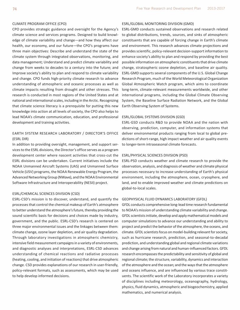
74 Five Year Research and Development Plan 2013-2017
CliMAtE PROGRAM OFFiCE (CPO)CPO provides strategic guidance and oversight for the Agency’s climate science and services programs. Designed to build knowl-edge of climate variability and change—and how they affect our health, our economy, and our future—the CPO’s programs have three main objectives: Describe and understand the state of the climate system through integrated observations, monitoring, and data management; Understand and predict climate variability and change from weeks to decades to a century into the future; and improve society’s ability to plan and respond to climate variability and change. CPO funds high-priority climate research to advance understanding of atmospheric and oceanic processes as well as climate impacts resulting from drought and other stresses. this research is conducted in most regions of the United States and at national and international scales, including in the Arctic. Recognizing that climate science literacy is a prerequisite for putting this new knowledge into action at all levels of society, the CPO also helps to lead NOAA’s climate communication, education, and professional development and training activities.
EARtH SYStEM RESEARCH lABORAtORY / DiRECtOR’S OFFiCE (ESRl DiR)in addition to providing oversight, management, and support ser-vices to the ESRl divisions, the Director’s office serves as a program development center where nascent activities that cross-cut the ESRl divisions can be undertaken. Current initiatives include the NOAA Unmanned Aircraft Systems (UAS) and Unmanned Surface Vehicle (USV) programs, the NOAA Renewable Energy Program, the Advanced Networking Group (NWave), and the NOAA Environmental Software infrastructure and interoperability (NESii) project.
ESRl/CHEMiCAl SCiENCES DiViSiON (CSD)ESRl-CSD’s mission is to discover, understand, and quantify the processes that control the chemical makeup of Earth’s atmosphere to better understand the atmosphere’s future, thereby providing the sound scientific basis for decisions and choices made by industry, government, and the public. ESRl-CSD’s research is centered on three major environmental issues and the linkages between them: climate change, ozone layer depletion, and air quality degradation. through laboratory investigations in atmospheric chemistry, intensive field measurement campaigns in a variety of environments, and diagnostic analyses and interpretations, ESRl-CSD advances understanding of chemical reactions and radiative processes (heating, cooling, and initiation of reactions) that drive atmospheric change. CSD provides explanations of our research in user-friendly, policy-relevant formats, such as assessments, which may be used to help develop informed decisions.
ESRl/GlOBAl MONitORiNG DiViSiON (GMD)ESRl-GMD conducts sustained observations and research related to global distributions, trends, sources, and sinks of atmospheric constituents that are capable of forcing change in Earth’s climate and environment. this research advances climate projections and provides scientific, policy-relevant decision-support information to enhance society’s ability to plan and respond by providing the best possible information on atmospheric constituents that drive climate change, stratospheric ozone depletion, and baseline air quality. ESRl-GMD supports several components of the U.S. Global Change Research Program, much of the World Meteorological Organization Global Atmospheric Watch program, which aims to coordinate long-term, climate-relevant measurements worldwide, and other international programs, including the Global Climate Observing System, the Baseline Surface Radiation Network, and the Global Earth Observing System of Systems.
ESRl/GlOBAl SYStEMS DiViSiON (GSD)ESRl-GSD conducts R&D to provide NOAA and the nation with observing, prediction, computer, and information systems that deliver environmental products ranging from local to global pre-dictions of short-range, high impact weather and air quality events to longer-term intraseasonal climate forecasts.
ESRl/PHYSiCAl SCiENCES DiViSiON (PSD)ESRl-PSD conducts weather and climate research to provide the observation, analysis, and diagnosis of weather and climate physical processes necessary to increase understanding of Earth’s physical environment, including the atmosphere, ocean, cryosphere, and land, and to enable improved weather and climate predictions on global-to-local scales.
GEOPHYSiCAl FlUiD DYNAMiCS lABORAtORY (GFDl)GFDl conducts comprehensive long-lead time research fundamental to NOAA’s mission of understanding climate variability and change. GFDl scientists initiate, develop and apply mathematical models and computer simulations to advance our understanding and ability to project and predict the behavior of the atmosphere, the oceans, and climate. GFDl scientists focus on model-building relevant for society, such as hurricane research, prediction, and seasonal-to-decadal prediction, and understanding global and regional climate variations and change arising from natural and human-influenced factors. GFDl research encompasses the predictability and sensitivity of global and regional climate; the structure, variability, dynamics and interaction of the atmosphere and the ocean; and the ways that the atmosphere and oceans influence, and are influenced by various trace constit-uents. the scientific work of the laboratory incorporates a variety of disciplines including meteorology, oceanography, hydrology, physics, fluid dynamics, atmospheric and biogeochemistry, applied mathematics, and numerical analysis.

75 Environmental Understanding to Ensure America’s Vital and Sustainable Future Research and Development at NOAA
GREAt lAKES ENViRONMENtAl RESEARCH lAB (GlERl)GlERl conducts research and provides scientific leadership to understand, observe, assess, and predict the status and changes of Great lakes and coastal marine ecosystems to educate and advise stakeholders of optimal management strategies. GlERl houses a multidisciplinary scientific core focusing on research that leads ecosystem forecasts on physical hazards, water quality and quantity, human health, invasive species, and fish recruitment and productivity. GlERl places special emphasis on a systems approach to problem-oriented research to develop environmental service tools. it houses NOAA’s National invasive Species Center and the NOAA Center of Excellence for Great lakes and Human Health.
NAtiONAl SEA GRANt COllEGE PROGRAM (Sea Grant) the National Sea Grant Program works closely with the 30 state Sea Grant programs located in every coastal and Great lakes state and Puerto Rico. Sea Grant provides a stable national infra-structure of programs serving as the core of a dynamic, national university-based network of over 300 institutions involving more than 3,000 scientists, engineers, educators, students, and outreach experts. this network works on a variety of topics vital to human and environmental health—topics such as healthy coastal ecosystems, hazard resilience in coastal communities, a safe and sustainable seafood supply and sustainable coastal development. through their research, education, and outreach activities, Sea Grant has helped position the United States as the world leader in marine research and the sustainable development of coastal resources. Sea Grant activities exist at the nexus of local, state, national, and sometimes international interests. in this way, local needs receive national attention, and national commitments are fulfilled at the local level.
NAtiONAl SEVERE StORMS lABORAtORY (NSSl) NSSl conducts research to improve accurate and timely forecasts and warnings of hazardous weather phenomena such as deadly tornadoes, damaging hail and high winds, dangerous lightning, flash floods, blizzards, and ice storms, in order to save lives and reduce property damage. NSSl accomplishes this goal through a balanced program of research to advance the understanding of high-impact weather processes, research to improve forecasting and warning techniques, development of new operational observing tools such as advanced weather radar, and transfer of this knowledge, techniques, and tools to the National Weather Service and other agencies.
OCEAN ACiDiFiCAtiON PROGRAM (OA) the NOAA Ocean Acidification Program (OAP) was established by SEC. 12406. of the 2009 Federal Ocean Acidification Research and Monitoring Act (FOARAM) to coordinate research, monitoring, and other activities to improve understanding of ocean acidification. the OAP maintains a long-term OA monitoring; conducts research designed to enhance conserving marine ecosystems sensitive to OA;
promotes OA educational opportunities; engages national public outreach activities related to OA and its impacts; and coordinates OA activities across other agencies and appropriate international ocean science bodies. As part of its responsibility, the OAP provides grants for critical research projects that explore the effects on ecosystems and the socioeconomic impacts.
OFFiCE OF OCEAN EXPlORAtiON AND RESEARCH (OER)the NOAA Ocean Exploration (OE) program was established in 2001 in response to the report of the President’s Panel on Ocean Exploration and focuses on: (1) mapping and characterizing the 95% of the ocean that is currently unexplored; (2) investigating poorly known ocean processes at multiple scales; (3) developing new sensors and systems; and (4) engaging stakeholders in new and innovative ways. OE investigates unknown ocean areas and phenomena, and employs an interdisciplinary scientific approach to ensure broad and comprehensive results that catalyze future research. the program invests in: (1) extramural grants; (2) telep-resence-enabled expeditions using the Nation’s only dedicated ship of exploration, the NOAA Ship Okeanos Explorer; (3) interagency partnership expeditions; and (4) participation in major national and international initiatives. Other key areas of investment include data and information management and product development, and education and outreach, which ensure the information derived from each expedition and project is widely distributed. OE continues to break new ground in the research, development, testing and evalua-tion, and application of undersea, ship-based, and communications technologies. the NURP component of OER provides NOAA with the unique ability to engage scientists in cutting edge research required to follow up on discoveries made during the course of exploration. NURP centers include the Hawaii Undersea Research lab at the University of Hawaii, the West Coast and Polar Regions Center at the University of Alaska Fairbanks, and the Cooperative institute for Ocean Exploration, Research and technology operated by the Harbor Branch Oceanographic institute at Florida Atlantic University and the University of North Carolina Wilmington. NURP supports the National institute of Undersea Science and technology at the University of Mississippi. NURP, through the University of North Carolina Wilmington, also operates the NOAA-owned Aquarius Undersea Habitat, the only manned undersea research facility, located in the Florida Keys. NURP provides extramural grants to both the federal and non-federal research community, while assisting scientists in acquiring data and observations that provide the information necessary to further NOAA’s priority goals specific to increasing our knowledge of the oceans.
OFFiCE OF WEAtHER AND AiR QUAlitY (OWAQ)the OWAQ Program helps provide improved weather forecast information and products to the Nation by facilitating, coordinating, and transitioning into applied weather and air quality research in

76 Five Year Research and Development Plan 2013-2017
NOAA. OWAQ programs provide outreach, linkage, and coordination between NOAA, other government agencies, and the academic and private sectors, both within the U.S. and internationally. OWAQ strives to ensure NOAA is optimally leveraging weather and air quality research capacity. OWAQ manages the overall U.S. Weather Research Program (USWRP) effort in support of research for air quality forecasting, societal benefits, and related weather research through projects with such internal and external partners as the National Center for Atmospheric Research (NCAR) and NOAA’s Co-operative institutes. NOAA’s USWRP seeks to improve weather and air quality forecast information and products by funding, facilitating, and coordinating cutting-edge research to improve weather and air quality predictions to protect lives and property of the American public and inform weather sensitive U.S. industry.
PACiFiC MARiNE ENViRONMENtAl lABORAtORY (PMEl)PMEl carries out interdisciplinary investigations in oceanography and atmospheric science and develops and maintains efficient and effective ocean observing systems. Results from PMEl research activities contribute to improved scientific understanding of the changing climate systems and its impacts, improved tsunami forecast capabilities, and improved understanding of the impacts of climate and ocean conditions on marine ecosystems. PMEl cultivates innovative technologies to improve research and observing capa-bilities that can be transferred to operations and private industry.
tECHNOlOGY PARtNERSHiPS OFFiCE (tPO)the NOAA technology Partnerships Office, or tPO, serves the needs of both NOAA inventors and U.S. companies looking to partner with NOAA or license our technologies. located in Silver Spring, MD, the NOAA tPO oversees both NOAA’s Small Business innovation Research (SBiR) Program and the technology transfer Program. the technology Partnerships Office also provides specific technical and communication/outreach services to all NOAA labs. this office provides answers to commonly asked questions from staff and the public, as well as resources to make the process of locating NOAA’s latest, most innovative technologies and partnering opportunities as easy as possible.
NOAA Office of Marine and Aviation Operations (OMAO)
MARiNE AND AViAtiON OPERAtiONS CENtERS (MOC) OMAO operates a wide variety of specialized aircraft and ships to complete NOAA’s environmental and scientific missions. NOAA’s ship fleet provides hydrographic survey, oceanographic and atmospheric research, and fisheries research vessels to support NOAA’s research activities. NOAA also operates a fleet of fixed-wing and aircraft that collect the environmental and geographic data essential to NOAA hurricane and other weather and atmospheric research; provide aerial support for remote sensing projects; conduct aerial surveys for hydrologic research to help predict flooding potential from snow melt;, and provide support to NOAA’s fishery and protected species research. to complement NOAA’s research fleet, NOAA’s ship and aircraft support needs are met through contracts for ship and aircraft time with other sources, such as the private sector and the university fleet.

77 Environmental Understanding to Ensure America’s Vital and Sustainable Future Research and Development at NOAA
APPENDIx c. SuPPORTINg INFORMATION
** this counts people working at a NOAA facility, whether ornot the person is a federal employee, who are encouraged orexpected to publish peer-reviewed technical reports, journalarticles, or other peer-reviewed materials – even if thosepeople would not be a lead author. Each R&D unit leader hadthe option to include additional employees whose scientificwork is integral to the scientific research of the unit and/or who facilitate and enable peer-reviewed publications but may not necessarily appear as co-authors on the papers.
APPENDIx D. REFERENcES
Carleton, t. l. (2010). The value of vision in radical technological innovation. Dissertation, Stanford University Department of Mechanical Engineering.
Daniel Sarewitz (2003). Does Science Policy Exist, and If So, Does it Matter? Some Observations on the U.S. R&D Budget. Discussion Paper for Earth institute Science, technology, and Global Develop-ment Seminar, April 8, 2003. Available at: http://www.cspo.org/documents/budget_seminar.pdf
Fisheries Economics of the United States, 2010. NOAA technical Memorandum. NMFS- F/SPO-120. October 2011.
Freeman, C., and Soete, l. (1997). The economics of industrial innovation. Cambridge, MA: Mit Press.
lazo, J.K., R.E. Morss, and J.l. Demuth. (2009): 300 Billion served: Sources, perceptions, uses, and values of weather forecasts. Bulletin of the American Meteorological Society, 90: 785-798.
National Academies of Science. Completing the Forecast: Char-acterizing and Communicating Uncertainty for Better Decisions Using Weather and Climate Forecasts. National Academies Press, Washington, DC. 2006.
National Oceanic and Atmospheric Administration. 20 year Research Vision. May 2005.
National Oceanic and Atmospheric Administration. Next Generation Strategic Plan. December 2010.
National Oceanic and Atmospheric Administration. Research in NOAA: toward Understanding and Predicting Earth’s Environment. January 2008.
National Oceanic and Atmospheric Administration. NOAA’s Arctic Vision and Strategy. February 2011.
NOAA Science Advisory Board (2012). R&D Portfolio Review Task Force – Additional Information, Available at: http://www.sab.noaa.gov/Meetings/2012/november/PRtF_revised_consolidated_5%20November_2012.pdf
NOAA Science Advisory Board (2004). Review of the Organization and Management of Research in NOAA. A Report to the NOAA Science Advisory Board. the Research Review team.
Specialization Number of People
Natural Resources Management and Biological Sciences
1296
Physical Sciences 1063
Mathematics and Statistics 128
Engineering and Architecture 80
Social Science, Psychology, and Welfare 67
information technology 16
Other 70
Table 1. Number of NOAA bench scientists by discipline**
Employment Status Number of People
Federal employees 1724
University, non-profit employees 474
Contractors and consultants 379
Post-docs or fellows 85
Other 58
Table 2. Number of NOAA bench scientists by employment status **

78 Five Year Research and Development Plan 2013-2017
NOAA testimony, COMMittEE ON SCiENCE, SPACE, AND tECHNOl-OGY, U.S. HOUSE OF REPRESENtAtiVES, July 25, 2012
Nowotny, H., Scott, P., and Gibbons, M. (2001). Re-thinking science: Knowledge and the public in an age of uncertainty. Cambridge UK: Wiley.
OECD (2012), “Main Science and technology indicators”, OECD Science, Technology and R&D Statistics (database). doi: 10.1787/data-00182-en
Organisation for Economic Co-operation and Development (OECD), 2002. Glossary of Key terms in Evaluations and Results Based Management. OECD Publications, Paris, France.
Rogers, P. J., Petrosino, A., Huebner, t. A., and Hacsi, t. A. (2000). Program theory evaluation: Practice, promise, and problems. New Directions for Evaluation, 2000: 5-13.
Sandifer, P., Dole, R. 2010. Strengthening NOAA Science: Findings from the NOAA Science Workshop.
Stokes, D. (1997). Pasteur’s quadrant : Basic science and technolog-ical innovation. Washington D.C.: Brookings institution Press.
teisberg, t., Weiher, R., and A. Khotanzad. (2005). the Economic Value of temperature Forecasts in Electricity Generation. Bulletin of the American Meteorological Society, 86: 1765 – 1771.
US Council on Competitiveness. (2005) Innovate America: National innovation initiative summit and report. Washington DC: US Council on Competitiveness.


©iStockphotos.com/Fernando Alonso Herrero