level 2 flora and vegetation survey · 2016-11-19 · level 2 flora and vegetation survey . i . a ....
TRANSCRIPT
APPENDIX 3
Level 2 Flora and Vegetation
Survey
i
A
LEVEL 2
FLORA AND VEGETATION
SURVEY OF
PROPOSED SAND MINING AREA
AT
LOT 467, WARTON RD:
Prepared for
RPS
by
Brian Morgan
Consultant Plant Biologist
May 2011

i
TABLE OF CONTENTS EXECUTIVE SUMMARY i 1.0 INTRODUCTION 1 1.1 Background 1 1.2 Purpose of the study 1 1.3 The survey area 1 2.0 SITE DESCRIPTION AND BACKGROUND INFORMATION 3 2.1 Physical Environment 3 2.1.1 Climate 3 2.1.2 Geomorphology of the survey area 3 2.2 Flora and vegetation background 3 2.2.1 Vegetation 3 2.2.1.1 Regional vegetation 3 2.2.1.2 Rare vegetation: Threatened Ecological Communities (TEC’s) 4 and Priority Ecological Communities (PEC’s) 2.2.1.3 BushForever Sites 5 2.2.1.4 Vegetation linkages 5 2.2.2 Rare flora 7 2.3 Wetlands 7 3.0 METHODS AND LIMITATIONS 13 3.1 Introduction to the field survey 13 3.2 Vegetation survey 13 3.2.1 Methods of the vegetation survey 13 3.2.2 Limitations of the vegetation survey 14 3.3 Flora survey 14 3.3.1 General flora survey methods 14 3.3.2 Rare flora searches 15 3.3.3 Limitations of the flora survey 15
ii
TABLE OF CONTENTS (cont) 3.4 Vegetation mapping 16 3.4.1 Methods for vegetation mapping 16 3.4.2 Wetland vegetation mapping 16 3.5 Floristic Community Types and PATN analysis of vegetation units 16 3.5.1 Introduction 16 3.5.2 Data storage and handling 16 3.5.3 Data preparation and compatibility 18 3.5.4 PATN analysis 18 3.5.5 Limitations of the floristic analysis 18 3.6 Identification of Threatened Ecological Communities (TEC’s) 19 and Priority Ecological Communities (PEC’S). 3.7 Flora and vegetation and regional significance 19 4.0 FLORA OF THE SURVEY AREA 20 4.1. Flora list for the survey area 20 4.2 Significant flora and flora of interest in the survey area 20 4.2.1 Declared Rare Flora (DRF) recorded in the survey area 20 4.2.2 Priority flora species recorded from the survey area 21 4.2.3 Other species of regional significance recorded in the survey area 21 4.2.3.1 Hensmania turbinate 21 4.2.3.2 Pultenaea ochreata 21 4.2.4 Other species of interest recorded in the survey area 22 5.0 VEGETATION OF THE SURVEY AREA 24 5.1 Vegetation description 224 5.1.1 Introduction to the vegetation descriptions 24 5.1.2 Vegetation of the Rocla Warton Rd survey area 24 5.1.2.1 Overview 24

iii
TABLE OF CONTENTS (cont) 5.1.2.2 Vegetation units 25 (i) Banksia attenuata-Banksia menziesii low woodlands on dune slopes 25 (ii) Melaleuca preissiana mixed woodlands on gentle slopes and flats 25 aroundd the base of the dune (iii) Pericalymma heaths and sedgelands on flats (dampland/palusplain). 29 5.2 Wetland vegetation 31 5.3 Vegetation condition 34 5.4 Lomandra hermaphrodita and L. maritima occurrence : host plants 37 of the Graceful Sun Moth 6.0 FLORISTIC COMMUNITY TYPES (FCT’S), THREATENED ECOLOGICAL COMMUNITIES (TEC’S) AND PRIORITY ECOLOGICAL COMMUNITIES (PEC’S) 38 6.1 Floristic analysis 38 6.1.1 Data Compatability 38 6.1.2 Determination of Floristic Community Types (FCT) by classification 38 6.1.3 Determination of Floristic Community Types (FCT) using nearest 38 neighbours method 6.1.4 Combining the results: assignment of Floristic Community Types 38 (FCT) to the Rocla Warton Rd quadrat sites 6.2 Rocla Warton Rd vegetation units, their Floristic Community Types 39 and assessment for Threatened Ecological Communities (TEC’s) and Priority Ecological Communities (PEC’s) 7.0 REGIONAL SIGNIFICANCE ASSESSMENT 41 8.0 ACKNOWLEDGEMENTS 43 9.0 REFERENCES 44
iv
TABLE OF CONTENTS (cont) APPENDICES APPENDIX ONE. The Department of Environment and Conservation Declared Rare Flora and Priority Flora Categories (from Smith, 2010) 47 APPENDIX TWO. Vegetation structural table of Trudgen based on Aplin's (1979) modification of Specht's classification 48 APPENDIX THREE. Vegetation condition scale and descriptions 49 APPENDIX FOUR Flora list for the Rocla Warton Rd survey area 50 APPENDIX FIVE. Quadrat descriptions and species lists for the 57 Rocla Warton Rd survey area APPENDIX SIX. Releve and mapping note descriptions and species lists 64 for the Rocla Warton Rd survey area APPENDIX SEVEN. Banksia tree death locations noted in the survey area. 66 APPENDIX EIGHT Reproduction of a report ‘FCT Analysis Warton Rd 67 Sites’ by Mr Ted Griffin FIGURES Figure 1. Location of the Rocla Warton Rd survey area. 2 Figure 2. Swan Coastal Plain Vegetation Complexes in the Rocla 6 Warton Rd survey area (adapted from Heddle et al., 1980). Figure 3. Locations of DEC records of significant flora and TEC/PEC’s 8 previously recorded in the Rocla Warton Rd locality. Figure 4. BushForever sites and geomorphic wetlands in the Rocla 12 Warton Rd locality. FIGURE 5. Vegetation map for the Rocla Warton Rd survey area. 26 FIGURE 6 Wetland vegetation occurrence in the Rocla Warton Rd 33 survey area. Figure 7. Vegetation condition at the Rocla survey area. 35

v
TABLE OF CONTENTS (cont) TABLES Table 1. Declared Rare and Priority Flora previously recorded within a 5 kilometre radius of the Rocla Warton Rd survey area 9 Table 2. Wetland classification based on permancy of water and a global 11 geomorphic classification system (reproduced from Department of Environmental Protection, 2000b; after Semeniuk in Hill et al., 1996). Table 3. List of a selection of plant species considered to be obligate 17 wetland species in south-west Western Australia. Table 4. Number of species recorded in the Rocla Warton Rd survey 20 quadrats. Table 5. Abbreviations for species names that were used in vegetation 24 unit codes. Table 6. Rocla Warton Rd vegetation units and their wetland status 32 Table 7. Summary of Rocla Warton Rd PATN Analysis results. (Adapted 39 from report by EA Griffin which is reproduced in full in Appendix 8). Table 8. Summary of Rocla Warton Rd survey area vegetation units 40 and FCT’s. Table 9. Summary of Floristic Community Types occurring in the 40 Rocla Warton Rd survey area. Table 10. Regional Significance Assessment: Rocla Warton Rd 42 PLATES Plate 1. Pultenaea ochreata. (Photograph reproduced from FloraBase, 21 Dept of Environment and Conservation website). Plate 2. Leucopogon sp. Murdoch (M. Hislop 1037). (Photograph 22 reproduced from Flora Base, Dept of Environment and Conservation website). Plate 3. Banksia attenuata-Banksia menziesii low woodland unit ‘BaBm’ 27 at quadrat WR3. Plate 4. Vegetation unit ‘MpAa’ at quadrat WR4. 27 Plate 5. Vegetation unit ‘MpBmBa’ at releve site WCR1. 28

vi
TABLE OF CONTENTS (cont) PLATES (cont) Plate 6. Pericalymma ellipticum heath vegetation, ‘Pe’, at releve site WCR2. 30 Plate 7. Schoenus subfascicularis sedgeland vegetation unit ‘Ss’ at 30 quadrat WR5. Plate 8. Vegetation unit ‘AcHa’ at quadrat WR6. 31 Plate 9. Completely Degraded old sand mine area at the northern end of 34 the survey area. Plate 10. Banksia tree deaths in bushland just south of the old northern 36 sand mine Plate 11. Banksia attenuata and Banksia menziesii deaths at the base of 36 the dune on the east side of the survey area.

i
EXECUTIVE SUMMARY Rocla Quarry Products is proposing to extract sand from parts of mining leases M70/1088 and M70/1142, which are located on Lot 467 Jandakot Rd, Banjup. The survey area covered the proposed excavation area and was about 11.3 hectares. A Level 2 survey was conducted in accordance with the Environmental Protection Authority’s Guidance statement No 51 . The Rocla Warton Rd survey area lies near the western edge of the Southern River unit of the Bassendean Dune landform system. The survey area was therefore located near the western boundary of the Southern River vegetation complex. In addition, the survey area bushland
• is part of a north-south linkage between Gibbs Rd and the Jandakot Airport/Canningvale bushlands;
• has a Resource Enhancement wetland abutted the western survey area boundary and a Conservation category wetland abutted the eastern survey area boundary; and
• is part of BushForever site 390 ‘Fraser Rd Bushland, Banjup’, which is contiguous with a number of other BushForever sites.
One hundred and fifty five (155) native plants were recorded in the Rocla Warton Rd survey area. Thirty eight (38) non-native species were also recorded. The number of native species recorded was probably a moderate number for the area (eleven hectares). The species richness of quadrats was greatest in the Banksia woodland and low in the dampland sites. No Declared Rare Flora or Priority flora species were recorded in the Rocla Warton Rd survey area. Two plant species recorded in the survey area, Hensmania turbinata and Pultenaea ochreata, were considered to have regional significance. Six vegetation units were described in the remnant bushland in the Rocla Warton Rd survey area. Banksia attenuata-Banksia menziesii low woodlands covered the dune crest and slopes that occupied most of the survey area. Eucalyptus todtiana occurred in scattered patches across the dune, but occurred more consistently on the lower slopes with the Banksia woodland. Transitional dryland vegetation in the form of mixed woodlands with scattered Melaleuca preissiana trees occurred on the gentle slopes along
ii
the base of the dune on the western edges and parts of the eastern edges of the survey area. Small areas of wetland vegetation that included Melaleuca preissiana low closed forest and Pericalymma ellipticum heaths and Schoenus subfascicularis sedgelands (seasonal damplands) occurred in the south-western, north-western and south-eastern corners of the survey area. The vegetation in the survey area was mostly rated Very Good to Excellent, with the vegetation condition rated Excellent at a number of sample locations on the dunes and flats. The condition of the wetland vegetation was Very Good to Excellent. Completely Degraded areas in the northern and southern parts of the survey area were former sand mines. Weed cover was generally low throughout the remnant bushland and were only abundant in the Completely Degraded areas. Banksia spp. deaths, including recent deaths, were noted on some parts of the dune slopes in the survey area. The deaths and decline of Banksia trees at this site probably indicate the presence of the Dieback fungus Phytophthera cinnamomi. However, other agents such as fire and drought (including falling water tables), as well as other pathogens, may also be responsible for Banksia tree deaths. A dieback survey by accredited ‘dieback interpreters’ would be required to confirm if Dieback is present and if so, over what area. Lomandra maritima was not recorded in the Rocla Warton Rd survey area. However, Lomandra hermaphrodita plants were recorded at all three of the quadrats located on the dune slopes and are probably scattered on the dune slopes. Lomandra hermaphrodita and L. maritima are two known food plants of the Graceful Sun Moth (Synemon gratiosa). Mr Ted Griffin concluded that the Rocal Warton Rd dataset was probably sufficiently compatible with the Swan Coastal Plain dataset to obtain reliable PATN floristic determinations. The dune Banksia woodland vegetation sites were all most similar to Floristic Community Type (FCT) 23a. The Schoenus subfascicularis sedgeland vegetation was consistently similar to FCT5 dampland sites. The Adenanthos cygnorum-Hypocalymma angustifolium shrubland site had mixed affinities, but had strong affinity to dampland FCT4 vegetation. The Melaleuca preissiana low open forest vegetation had some affinity with dampland vegetation FCT5. Both the Melaleuca preissiana low open forest and Adenanthos cygnorum-Hypocalymma angustifolium shrubland vegetation were deemed to be wetland vegetation because of the floristic affinities and because of the presence and cover of obligate wetland species.
iii
No Threatened Ecological Communities or Priority Ecological Communities were found to be present in the vegetation units in the survey area, although vegetation unit ‘AcHa’ had some affinity with FCT22, a Priority Ecological Community (Priority 2). FCT’s were inferred for two described vegetation units. Using the criteria for determination of regional significance of natural areas set out in the EPA Guidance Statement No. 10, the Rocla Warton Rd survey area was assessed as regionally significant for flora and vegetation on the following grounds:
• Representation of ecological communities (less than 10% of Southern River Complex is protected); and
• Maintaining linkages (part of a ‘regionally significant but not contiguous linkage of bushland/wetland area’).
1
1.0 INTRODUCTION 1.1 Background Rocla Quarry Products is proposing to extract sand from parts of mining leases M70/1088 and M70/1142, which are located in Lot 467 Jandakot Rd, Banjup. RPS Environmental recommended that a Level 2 flora and vegetation survey of the area, including a targeted search for Declared Rare Flora (DRF), should be undertaken to meet part of the approvals requirements. 1.2 Purpose of the study The purpose of the Level 2 flora and vegetation survey of Lot 467 Jandakot Rd was to:
• list the flora in the survey area, including any Significant flora; • map the vegetation and the vegetation condition in the survey area, including a
delineation of wetland vegetation boundaries; • Record quadrats and analyse the quadrat data to determine the vegetation
values in the survey area; • conduct a targeted search for Caladenia huegelii and other DRF in the survey
area; • report on the survey results.
The Level 2 survey was conducted in accordance with the Environmental Protection Authority’s (2004) Guidance for the assessment of Environmental Factors – Terrestial Flora and Vegetation Surveys for Environmental Impact Assessment in Western Australia (No 51). 1.3 The survey area The survey area covered the proposed excavation area in the Mining Lease areas M70/1088 and M70/1142 in Lot 467 Jandakot Rd, Banjup (here after referred to as ‘Rocla Warton Rd’ survey area; see Figure 1). The survey area mostly excluded the adjacent Conservation and Resource Enhancement Geomorphic wetland areas. The size of the survey area was approximately 11.3 hectares.
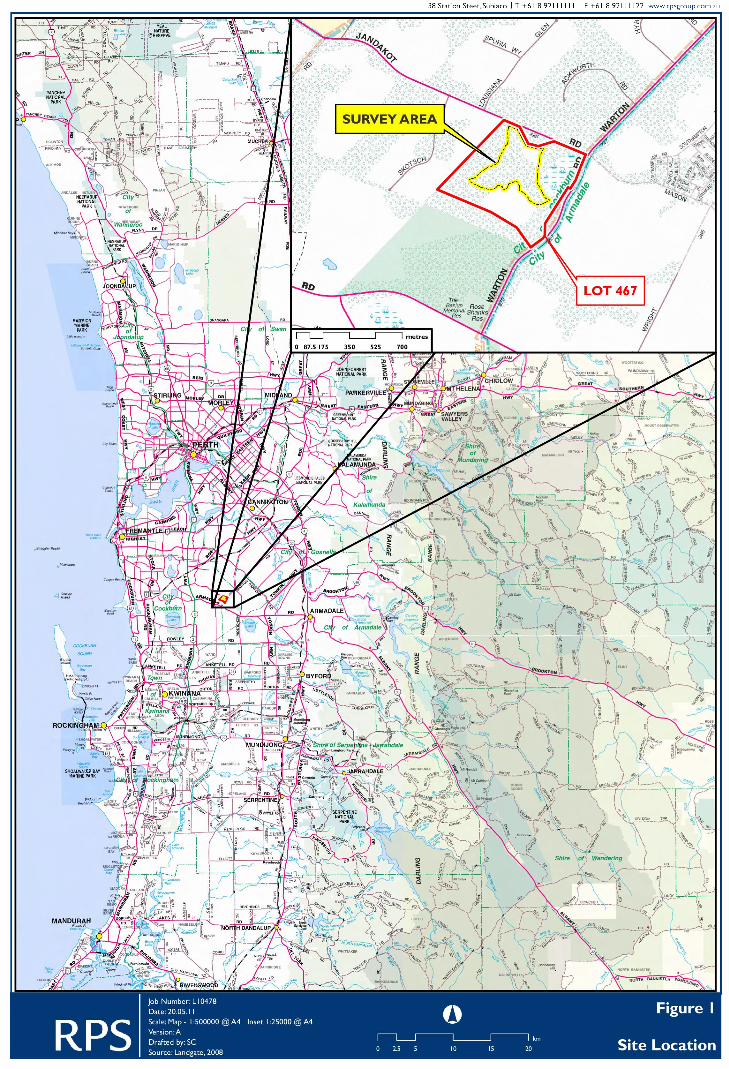

3
2.0 SITE DESCRIPTION AND BACKGROUND INFORMATION 2.1 Physical Environment 2.1.1 Climate The Swan Coastal Plain, which includes the survey area, has a Mediterranean type climate with hot, dry summers and mild, wet winters. 2.1.2 Geomorphology of the survey area The Swan Coastal Plain consists of a series of geomorphological elements which are sub-parallel to the present coastline (McArthur and Bettenay, 1960; Churchward and McArthur, 1980). Each of these geomorphic elements has distinctive geology, vegetation, topography and soils. The Rocla Warton Rd survey area lies near the western edge of the Southern River unit (McArthur and Bettenay, 1960). The Southern River unit and the Bassendean unit are two of the three units within the Bassendean Dune system, the oldest and furthest inland of the three main aeolian dune systems on the Swan Coastal Plain. The three units of the Bassendean Dune system differ mainly in the nature of associated swamps, with the Bassendean unit having peaty podzols in the swamps and the Southern River unit having swamps which often have a clay base as a result of sand blowing over alluvial soils (Churchward and McArthur, 1980). 2.2 Flora and vegetation background 2.2.1 Vegetation 2.2.1.1 Regional vegetation Beard (1980) defined boundaries for botanical provinces, districts and subdistricts for Western Australia on the basis of his vegetation mapping of the State. In this framework, the survey area lies in the Drummond Botanical Subdistrict (more or less equivalent to the Swan Coastal Plain and part of the Dandaragan Plateau) of the Darling Botanical District of the South Western Botanical Province of Western Australia. Heddle et al (1980) mapped the vegetation of part of the Drummond Botanical Subdistrict at a very broad scale, describing a series of vegetation complexes. These are related groups of vegetation associations found on particular landform-soil units (geomorphic elements, see above). They mapped a total of 38 vegetation complexes on the Swan Coastal Plain. The Rocla Warton Rd survey area is located near the western boundary of the Southern River Complex (Figure 2). The Southern River Complex was described as consisting of ‘an open woodland of Marri-Jarrah-Banksia
4
on the elevated areas and a fringing woodland of E. rudis-M. rhaphiophylla along the streams’ (Heddle et al., 1980). The vegetation of the ‘Bassendean Complex-Central and South’, the adjacent Complex to the west, was described as ranging from ‘woodland of Jarrah-Sheoak-Banksia on the sand dunes to a low woodland of Melaleuca spp. and sedgelands on the low-lying depressions and swamps’ (Heddle et al., 1980). It was also noted that ‘it includes the transition area of Jarrah and Pricklybark (Eucalyptus todtiana) in the vicinity of Perth’. More recently, an alternative analysis of the plant assemblages on the Swan Coastal Plain south of Gingin Brook was carried out using a floristic approach (Gibson et al., 1994) and was extended in 2000. This work identified 66 floristic community types in four floristic 'Super Groups' for the southern Swan Coastal Plain. These units are defined at a similar level of synthesis to that of Heddle et al. (Trudgen, 1999). The four 'super groups' of sites correlate closely with the major geomorphological elements on the Swan Coastal Plain (and also to rainfall), with the exception of one group which contained the seasonal wetlands, which includes sites across all geomorphological groups (Gibson et al., 1994). Floristic community types have not been mapped across the Swan Coastal Plain. 2.2.1.2 Rare vegetation: Threatened Ecological Communities (TEC’s) and Priority Ecological Communities (PEC’s) The Department of Conservation and Land Management has developed a procedure for identifying 'Threatened Ecological Communities' (Department of Environmental Protection 2000b; English and Blythe 1997). Threatened Ecological Communities (TEC's) are assigned to one of four categories: 'Presumed Totally Destroyed'; 'Critically Endangered'; 'Endangered' or 'Vulnerable' (Department of Environmental Protection, 2000b). On the Swan Coastal Plain, twenty five potential Threatened Ecological Communities, delineated by a number of floristic and other studies, have been assessed for threatened ecological community status. Of these, twenty four have been confirmed as 'threatened' (Department of Environmental Protection 2000b). Currently eighteen Floristic Community Types on the Swan Coastal Plain, as identified by Gibson et al. (1994), are recognized as Threatened Ecological Communities (Department of Environment and Conservation website, May 2011 (unpublished)). Priority Ecological Communities (PECs) include ‘possible threatened ecological communities that do not meet survey criteria or are not adequately defined’ (DEC,

5
unpublished). These are added to the DEC’s PEC’s list under Priorities 1, 2 and 3. Priority 4 status is given to “Ecological Communities that are adequately known, and are rare but not threatened or meet criteria for Near Threatened, or that have been recently removed from the threatened list. Conservation Dependent ecological communities are placed in Priority 5 (DEC, unpublished). The list of PECs (Department of Environment and Conservation website, May 2011 (unpublished)) includes some that are Floristic Community Types (FCT’s) as identified by Gibson et al. (1994). A search of the Department of Environment and Conservation’s TEC and PEC database found that there were a number of TEC’s and PEC’s recorded within a 5 kilometre radius of the survey area (Figure 3):
• TEC SCP08 (Vulnerable): ‘Herb rich shrublands in clay pans’; • TEC SCP10a (Endangered): ‘Shrublands on dry clay flats’; • PEC SCP22 (Priority 2): ‘Banksia ilicifolia woodlands, southern Swan
Coastal Plain (type 22)’; • PEC SCP21c (Priority 3): ‘Low lying Banksia attenuata woodlands or
shrublands (type 21c)’. 2.2.1.3 BushForever Sites The Rocla Warton Rd survey area is part of BushForever site 390 ‘Fraser Rd Bushland, Banjup’ (Department of Environmental Protection 2000a; Figure 4). It is contiguous with BushForever sites:
• BF site 388: Jandakot Airport, Jandakot; • BF site 389: Acourt Rd Bushland, Banjup; • BF site 472: Canning Vale Prison Bushland; • BF site 253: Harrisdale swamp and Adjacent Bushland,
Forrestdale/Wungong; 2.2.1.4 Vegetation linkages Large consolidated areas are considered the best options for viable conservation of natural ecosystems and populations (Department of Environmental Protection, 2000b). In the Perth Metropolitan Region, there are few large areas available for conservation, with most areas being relatively small in size (less than 100 hectares)

Southern River ComplexBassendean Complex-Central And\South
ARMADALE RD
WARTON RD
NICHOLSON RD
SKEET RD
KEANE RD
JANDAKOT RD
FRASER RD
RANFORD RD
ACOURT RD
MASON RD
TAPP
ER RD
LIDDE
LOW
RD
KWIN
ANA
FWY
FURLEY RD
WRIG
HT RD
ANSTEY RD
TAYL
OR R
D
REILLY RD
CUTLER RD
HARPER RD
SOLO
MON RD
PRIN
SEP R
D
BARTRAM RD
BERRIGAN DR
BEENYUP RD
DEAN RD
LAKE RD
COMMERCIAL RD
BORO
NIA
RD
LYON
RD
HARRISDALE DR
POLE
TTI R
D
BROOME ST
ALLEN RD
LEAKE ST
LAKES WY
STEINER AV
GUTT
ERID
GE R
D
HARMONY AV
MURIEL CT
UNIT
Y WY
GLEN IRIS DR
CESS
NA D
R
SKOT
SCH
RD
DEW
ST
MYALL PL
SWAMP RD
LYDON BVD
HYBRID CT
KNOCK PL
FOLL
AND
PDE
SCIANO AV
CLIFTON RD
BOEING WY
CHIV
ALRY
WY
DOLLIER ST
MUIR
CT
BALANNUP RD
DUMSDAY DR FORREST RD
EDENCOURT DR
BALFOUR ST
AVON
CR
MURD
OCH
WY
LOUISI
ANA GLEN
VERNA CT
DALEFORD WY
LOFTIES ST
HEBE RD
LAKEY ST
COLUMBIA PWY
WATERS AV
BATTERSEA RD
BROADWAY BVD
GLENDALE CR
ALABASTER DR
HARTWELL PDE PARK
VIEW
DR
PEARSON DR
BEELIAR DR
PAPERBARK L
HEBBLE LOOP
LINKAGE AV
BENALLA DR
BURNSIDE TCE
KENT
UCKY
CT
IMLAH CT
NORTH LAKE RD
STOR
TFOR
D RD
ACKWORTH RD
WIN
DCHI
ME TC
E
WEL
D ST
GOODWILL AV
SANGUINE WY
GILLEN WY
SCOFIELD PL
AVIOR AV
LOMB
E GDN
S
CARL
SON
PL
WHITEHORSE DR
SILKWOOD ST
VIRGILIA TCE DRISCOLL DR
MILLST
REAM DR
BORDEAUX PDE
ROEBUCK AV
PARDALOTE RD
OWLET L
STILL
S AV
LAUDERDALE DR
SHEPHERD CT
GLOBAL AV
BARCLAY WY
HYGE
IA BE
ND
GRENOBLE ST
DELMAR AV
HAWKESBURY RTT
REEVES ENT
BISCAY
NE WY
DUNLAP AV
ABAYA
ST
KUDOS CCT
GUNDARING TURN
BAYSTONE PDE
KEW WY
KULBARDI WY
GRAN
T PL
TURTLEDOVE RD
ALTHAM WY
UTOPIA LVIVA L
CHIARA AV
CALD
ER W
Y
PADUA RD
MYRRH L
SADDLE L
MINGARA AV
RUTHERFORD ENT
CHIFL
EY BR
ARNO L
MYSTIC ELB
FALC
ON P
L
BANKSIA CT
WATERFOOT LO
OP
BEND
EE D
R
RAVEN WY
PAR
CT
CASA PL
CHARIOT TURN
NINAN WY
BARN L
INGOT L
POSE
Y L
DELFT L
TURIN L
SOHO L
BARTRAM RD
TAPPER RD
BARTRAM RD BARTRAM RD
FRASER RD
BALFOUR ST
BEELIAR DR
SOLO
MON RD
WRIGHT RD
LAKE
Y ST
BEENYUP RD
FRASER RD
Figure 2Swan Coastal Plain Vegetation Complex Map
LEGENDSurvey AreaLot 467
Vegetation Complex BoundaryBassendean Complex-Central And\SouthSouthern River Complex
0 375 750 1,125 1,500187.5metres
°Job Number: L10478Date: 20.05.11Scale: 1:25000 @ A3Revision: 0Drafted by: SCSource: Cadastre & Orthophoto - Landgate 2010 Wetlands - DEC, 30.12.10 Vegetation - Heddle, 2002
38 Station Steet, Subiaco | T +61 8 92111111 | F +61 8 92111122 | www.rpsgroup.com.au

7
and isolated from other conservation areas (Department of Environmental Protection, 2000b). Consequently, the consideration of proximity to other natural areas and connectivity with them is considered important by the DEC in assessing the significance of natural areas. Linkages have been categorized by the DEC as follows (Department of Environmental Protection, 2000b):
• Regionally significant contiguous corridors of bushland/wetland areas; • Regionally significant fragmented bushland/wetland areas; • Regionally significant potential bushland/wetland areas.
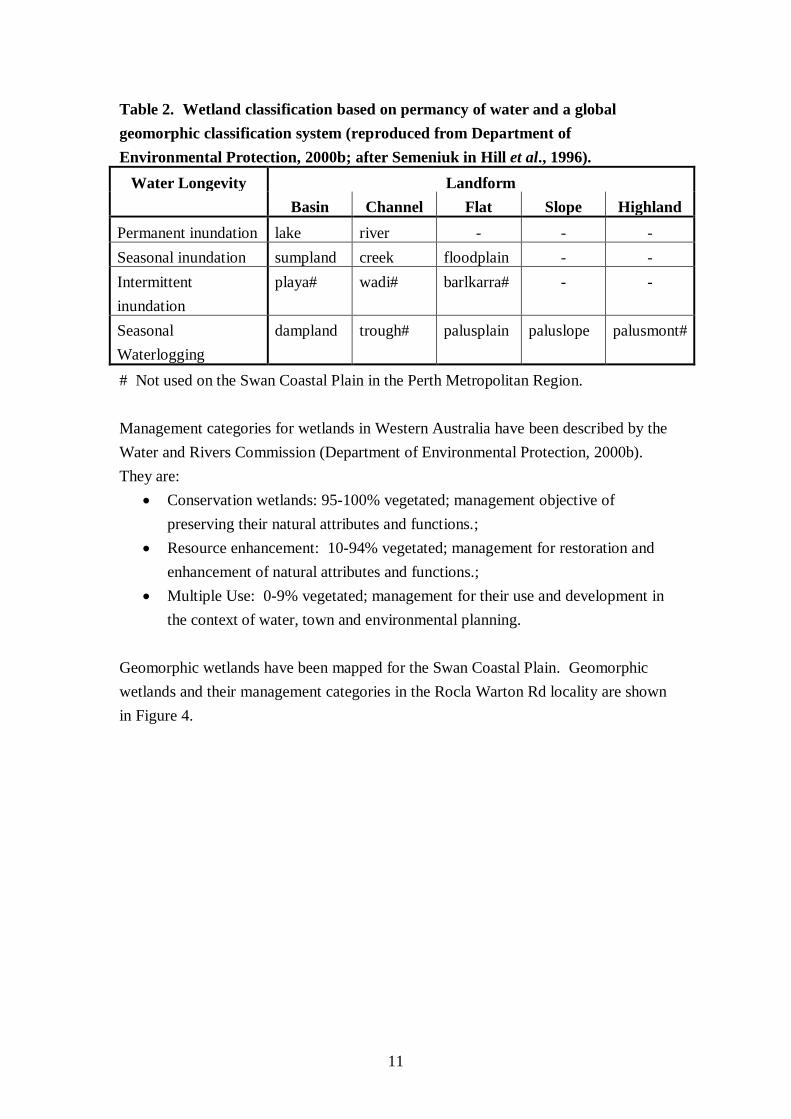
A map of existing and potential bushland/wetland linkages in the Perth Metropolitan Area (Department of Environmental Protection, 2000b) shows that the Rocla survey area is part of a north-south linkage between Gibbs Rd and the Jandakot Airport/Canningvale bushlands. This linkage has been assigned the status ‘Regionally Significant but not Contiguous Linkage of Bushland/Wetland Areas’. 2.2.2 Rare flora Twenty three (23) DRF and Priority species were recorded on the DEC database as having been previously recorded in the locality of the Rocla Warton Rd survey area (within 5 kilometre radius of Rocla Warton Rd) (Figure 3; Table 1). 2.3 Wetlands Western Australia’s wetlands have been defined as ‘areas of seasonally intermittently or permanently waterlogged soils or inundated land whether natural or otherwise, fresh or saline, e.g. waterlogged soils, ponds, billabongs, lakes, swamps, tidal flats, estuaries, rivers and their tributaries (Wetland Advisory Committee 1977, quoted in Department of Environmental Protection, 2000b). There are over 9600 wetlands covering over 25% of the Swan CoastalPlain land area (Balla, 1994). Semeniuk proposed a classification of wetlands for south-western Australia based on landform and water longevity (Hill et. al., 1996; Table 2).

!
!
!
!
!
!
!
!
!
!
!
!
!
!
!
!
!
!
!
!
!
!
!
!
!
!
!
!
!
!
!
!
!
!
!
!
!
!!!
!
!
!
!!
!
!
! Schoenus pennisetis
Schoenus pennisetis
Tripterococcus paniculatus
Tripterococcus paniculatus
Tripterococcus paniculatus
Tripterococcus paniculatus
Tripterococcus paniculatus
Byblis giganteaStylidium longitubum
Jacksonia gracillima
Schoenus capillifoliusSchoenus capillifolius
Cyathochaeta teretifolia
Jacksonia sericea
Jacksonia sericea
Aponogeton hexatepalus
Verticordia lindleyi subsp. lindleyi
Verticordia lindleyi subsp. lindleyi
Drosera occidentalis subsp. occidentalis
Diuris purdiei
Drakaea micrantha
Caladenia huegelii
Caladenia huegelii
Caladenia huegelii
Caladenia huegelii
Caladenia huegelii
Caladenia huegelii
Caladenia huegelii
Caladenia huegeliiCaladenia huegelii
Caladenia huegelii
Caladenia huegelii
Caladenia huegelii
Caladenia huegelii
Caladenia huegelii
Caladenia huegelii
Caladenia huegelii
Caladenia huegelii
Caladenia huegelii Rchb.f.
SCP08SCP08
SCP08SCP08
SCP08
SCP08
SCP08
SCP08
SCP08SCP08
SCP10aSCP10a
SCP10a
SCP10aSCP10a
SCP10aSCP10a
SCP10a
SCP10a
SCP10a
SCP22
SCP21c
SCP21cSCP21c
Figure 3Location of DEC Records of Rare Flora and TECs/PECs
LEGENDLot 467Survey Area
TEC / PEC LocationTEC (Endangered)TEC (Vulnerable)PEC (Priority 2)PEC (Priority 3)
Rare Flora Location! Declared Rare Flora! Priority 1! Priority 2! Priority 3! Priority 4
0 0.5 1 1.5 20.25km
°Job Number: L10478Date: 20.05.11Scale: 1:35000 @ A3Revision: 0Drafted by: SCSource: Cadastre & Orthophoto - Landgate 2010 DRF TEC/PEC - DEC
38 Station Steet, Subiaco | T +61 8 92111111 | F +61 8 92111122 | www.rpsgroup.com.au
BIBRALAKE
YANGEBUPLAKE
THOMSONSLAKE
FORRESTDALELAKE
JANDAKOTJANDAKOTAIRPORTAIRPORT
9
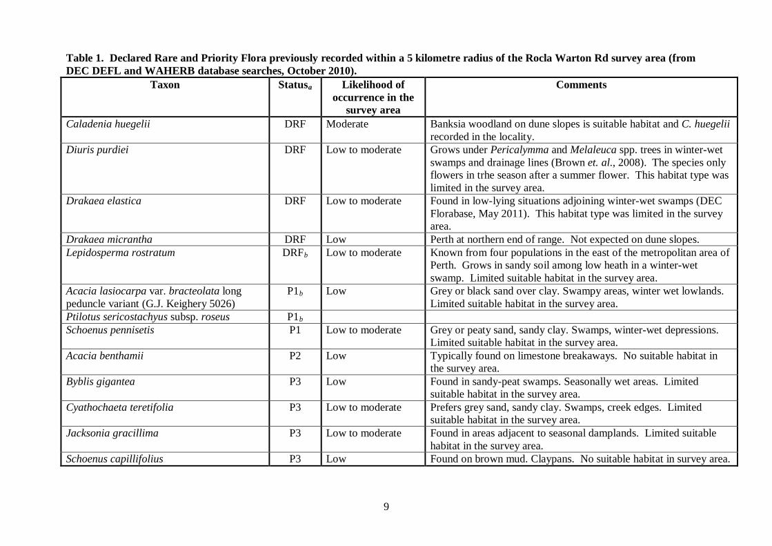
Table 1. Declared Rare and Priority Flora previously recorded within a 5 kilometre radius of the Rocla Warton Rd survey area (from DEC DEFL and WAHERB database searches, October 2010).
Taxon Statusa Likelihood of occurrence in the
survey area
Comments
Caladenia huegelii DRF Moderate Banksia woodland on dune slopes is suitable habitat and C. huegelii recorded in the locality.
Diuris purdiei DRF Low to moderate Grows under Pericalymma and Melaleuca spp. trees in winter-wet swamps and drainage lines (Brown et. al., 2008). The species only flowers in trhe season after a summer flower. This habitat type was limited in the survey area.
Drakaea elastica DRF Low to moderate Found in low-lying situations adjoining winter-wet swamps (DEC Florabase, May 2011). This habitat type was limited in the survey area.
Drakaea micrantha DRF Low Perth at northern end of range. Not expected on dune slopes. Lepidosperma rostratum DRFb Low to moderate Known from four populations in the east of the metropolitan area of
Perth. Grows in sandy soil among low heath in a winter-wet swamp. Limited suitable habitat in the survey area.
Acacia lasiocarpa var. bracteolata long peduncle variant (G.J. Keighery 5026)
P1b Low Grey or black sand over clay. Swampy areas, winter wet lowlands. Limited suitable habitat in the survey area.
Ptilotus sericostachyus subsp. roseus P1b Schoenus pennisetis P1 Low to moderate Grey or peaty sand, sandy clay. Swamps, winter-wet depressions.
Limited suitable habitat in the survey area. Acacia benthamii P2 Low Typically found on limestone breakaways. No suitable habitat in
the survey area. Byblis gigantea P3 Low Found in sandy-peat swamps. Seasonally wet areas. Limited
suitable habitat in the survey area. Cyathochaeta teretifolia P3 Low to moderate Prefers grey sand, sandy clay. Swamps, creek edges. Limited
suitable habitat in the survey area. Jacksonia gracillima P3 Low to moderate Found in areas adjacent to seasonal damplands. Limited suitable
habitat in the survey area. Schoenus capillifolius P3 Low Found on brown mud. Claypans. No suitable habitat in survey area.
10
Table 1 (cont). Declared Rare and Priority Flora previously recorded within a 5 kilometre radius of the Rocla Warton Rd survey area (from DEC DEFL and WAHERB database searches, October 2010).
Taxon Statusa Likelihood of occurrence in the
survey area
Comments
Stylidium longitubum P3 Low to moderate Sandy clay, clay. Seasonal wetlands. Limited suitable habitat in the survey area.
Aponogeton hexatepalus P4 Low Freshwater: ponds, rivers, claypans. No seasonally/perennially inundated areas in survey area.
Dodonaea hackettiana P4b Low Occurs on sand and outcroping limestone. No limestone outcropping in survey area.
Drosera occidentalis subsp. occidentalis P4 Low to moderate Occurs on sandy & clayey soils and around swamps & wet depressions. Limited suitable habitat in the survey area.
Grevillea thelemanniana P4b Low to moderate Prefers areas of sand, sandy clay, with winter-wet low-lying flats. Jacksonia sericea P4 Low Found on calcareous and sandy soils. Soil in survey area not
calcareous. Microtis quadrata P4b Low to moderate Grows around coastal swamps (Brown et al., 2008) Ornduffia submersa (formerly Villarsia submerse)
P4b Low Prefers freshwater pools, lakes, swamps, winter-wet depressions, claypans. Does not appear to be inundation in survey area. (Paczkowska and Chapman, 2000).
Tripterococcus paniculatus P4 Low to moderate Prefers grey, black or peaty sand and winter-wet flats. Verticordia lindleyi subsp. lindleyi P4 Low to moderate Occurs on sand, sandy clay in winter-wet depressions. Limited
suitable habitat in the survey area. a. The rare flora status classification definitions are set out in Appendix 1. b. Exact locations were not known for these taxa. Rather, they were caught by a search of Herbarium records by suburb name within 5 kilometres of the survey area (DP List).
11
Table 2. Wetland classification based on permancy of water and a global geomorphic classification system (reproduced from Department of Environmental Protection, 2000b; after Semeniuk in Hill et al., 1996).
Water Longevity Landform Basin Channel Flat Slope Highland
Permanent inundation lake river - - - Seasonal inundation sumpland creek floodplain - - Intermittent inundation
playa# wadi# barlkarra# - -
Seasonal Waterlogging
dampland trough# palusplain paluslope palusmont#
# Not used on the Swan Coastal Plain in the Perth Metropolitan Region. Management categories for wetlands in Western Australia have been described by the Water and Rivers Commission (Department of Environmental Protection, 2000b). They are:
• Conservation wetlands: 95-100% vegetated; management objective of preserving their natural attributes and functions.;
• Resource enhancement: 10-94% vegetated; management for restoration and enhancement of natural attributes and functions.;
• Multiple Use: 0-9% vegetated; management for their use and development in the context of water, town and environmental planning.
Geomorphic wetlands have been mapped for the Swan Coastal Plain. Geomorphic wetlands and their management categories in the Rocla Warton Rd locality are shown in Figure 4.

Site: 388Site: 388
Site: 342Site: 342
Site: 389Site: 389
Site: 390Site: 390
Site: 125Site: 125
Site: 253Site: 253
Site: 263Site: 263
Site: 413Site: 413
Site: 344Site: 344
Site: 472Site: 472
Site: 345Site: 345
Site: 262Site: 262
Site: 391Site: 391
Site: 391Site: 391
Site: 344Site: 344
Site: 245Site: 245
Site: 467Site: 467
Site: 0Site: 0
Site: 345Site: 345
Site: 465Site: 465
UFI 13328UFI 13328
UFI 7169UFI 7169
UFI 7168UFI 7168
Figure 4Bush Forever and Geomorphic Wetlands Within Survey Locality
LEGENDSurvey AreaLot 467Bush Forever Site
Geomorphic WetlandsConservationResource EnhancementMultiple UseNot Applicable
0 380 760 1,140 1,520190metres
°Job Number: L10478Date: 20.05.11Scale: 1:30000 @ A3Revision: CDrafted by: SCSource: Cadastre & Orthophoto - Landgate 2010 Wetlands - DEC, 30.12.10 Bush Forever - DPI, 30.09.09
38 Station Steet, Subiaco | T +61 8 92111111 | F +61 8 92111122 | www.rpsgroup.com.au

13
3.0 METHODS AND LIMITATIONS 3.1 Introduction to the field survey The Rocla Warton Rd flora and vegetation fieldwork was conducted on the 6th and 7th of October 2010, with a site revisit to re-record quadrats and finalise other works on the 28th of October 2010. 3.2 Vegetation survey 3.2.1 Methods of the vegetation survey Vegetation was described using quadrats, releves and mapping notes. Locations of sample sites were selected that were representative of observed variations in the vegetation and habitat. Suitable sites for the more detailed descriptions (quadrats) were limited to sites in Good or better condition, where a good suite of species representative of that vegetation type, were present. Six (6) quadrats, WR1 to WR6, were recorded. Quadrats were 10 metres by 10 metres in size and were marked out with a field measuring tape between fence dropper stakes, which were driven into the ground at each corner. The 10 metre by 10 metre quadrat dimensions were used firstly because a 100m2 sample area on the Swan Coastal Plain is considered to capture most species in a given plant community and secondly because that was the quadrat size used to collect data for the Gibson et al. (1994) Swan Coastal Plain study, with which the Rocla Warton Rd survey data set needed to be compatible. Each quadrat was photographed. A description of the quadrat location, the habitat, surface soil texture and colour were recorded and the time since the site was last burnt was estimated. The vegetation structure was described using a modification of Specht's vegetation description table by Aplin (1979; Appendix 2). To obtain more representative data for the overstorey cover, the tree layer(s) cover was estimated over a larger area around the quadrats. The condition of vegetation in the quadrat was described using the Keighery classification outlined in Bush Forever (Department of Environmental Protection, 2000b; see Appendix 3). All plant species occurring in a quadrat were recorded, along with their height, percentage cover and specimen number if collected. Where a plant species was not well known, a specimen was collected and allocated a specimen number. The specimens collected were pressed, dried and identified. The identifications were made by comparison to specimens in the reference and research collections of the
14
Western Australian Herbarium, by the use of keys in various papers and books and by relevant experts on various groups of flora that occur on the Swan Coastal Plain. The Department of Environment and Conservation Declared Rare and Priority Flora List (Smith, 2010; definitions in Appendix 1) was consulted as required to confirm the status of plant species in the survey area. The quadrats were revisited near the end of October to meet the Environmental Protection Authority’s (2004) Guidance No 51 requirements. The two visits improved quadrat sampling by increasing the chances of recording, in at least one visit, early and later season flowering plants. Two releves and three mapping notes were also recorded to describe the vegetation in the survey area. Releves are vegetation descriptions of an unbounded area around a point. Releve descriptions were similar to those for quadrats, but not all plant species were recorded, but rather some associated species were recorded. Mapping notes were an abbreviated form of releves descriptions. 3.2.2 Limitations of the vegetation survey The cover estimate of each plant species recorded in the quadrats was based on estimating species projected canopy cover. The assumption was made that for most species, canopy cover and projected foliar cover are reasonably similar, or that the difference is less than the level of accuracy of the estimates. There is a limit to the accuracy of the assignment of the different strata in the vegetation descriptions to structural units (for example, low open woodland, low woodland, low open forest, open shrubland, shrubland etc.). Referral of a stratum to a structural category depends on assessment of its cover. Such estimation is imprecise and it is not unusual for different observers to give quite different estimates of the cover of a species, or stratum in a stand. However, descriptive exercises such as that carried out for this report require only a moderate level of accuracy. 3.3 Flora survey 3.3.1 General flora survey methods The flora in the study area was recorded while describing and sampling the vegetation (quadrats, releves and mapping notes), while walking between the vegetation recording sites, while mapping the vegetation units and when conducting rare flora searches.

15
Plant species were recorded elsewhere in the study area if they had not been recorded at a quadrat or releve sampling site or if they were of particular interest. Where a plant species was not well known, a specimen was collected and allocated a specimen number. GPS coordinates were recorded (using a Garmin 60CX hand held GPS unit) whenever it was considered there was a possibility that the plant species may be of special interest. 3.3.2 Rare flora searches Grid searches for rare flora were conducted over the entire survey area on the 7th of October 2010. The main target was the giant spider orchid, Caladenia huegelii (Declared Rare Flora), because it had been recorded in the region and the Banksia woodland on dune slopes was considered to be suitable habitat for that taxon. Grid lines were spaced about 20 metres apart, with adjacent lines walked by one of three botanists. Despite a fairly early and dry Spring season, Caladenia huegelii plants were flowering at that time (Andrew Brown (DEC), pers. comm.). While searching for the Caladenia huegelii, other plants were also recorded if they were not well known, if there was some chance they may have been significant (DRF, Priority or Regionally Significant) or if they had not been recorded elsewhere in the survey area. 3.3.3 Limitations of the flora survey The major limitation of the flora survey is that any such survey is a sampling procedure of a variable environment with plant populations of variable growth habit, life span and flowering season. Some species, including annuals, are only available for collection for part of the year. This means that to locate all species that grow in an area is a substantial task, the success of which is related to the time available and the size and diversity of habitat in the survey. Consequently, it is possible that there are species present in the survey area that were not recorded during this survey as they have only low abundance on the land, or were not flowering at the time of the survey. However, this limitation was minimised by surveying the site and then revisiting the quadrats during early and late Spring respectively, increasing the number of annual taxa that were in or near some stage of flowering at a survey time. Given the limitations of the flora survey, it is likely that this survey recorded more than 85 to 90% of the vascular flora in the survey area. That is, while the flora survey was relatively thorough, it was possible that some species occurring in the survey area were not recorded.
16
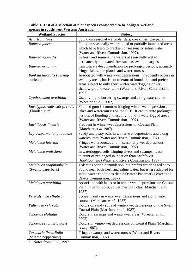
3.4 Vegetation mapping 3.4.1 Methods for vegetation mapping Vegetation units were recorded generally between plant community and plant association level. The vegetation unit boundaries were drawn on a computer generated aerial photograph while traversing the study area, using GPS coordinate readings to locate actual boundary positions. Orthocorrected aerial photography at 1:5000 was supplied by 360 Environmental PL. The vegetation mapping unit descriptions were based on the quadrat, releve and mapping note descriptions. The vegetation descriptions recorded in the field were later synthesized into vegetation units, with some reference to the floristic similarity of quadrats determined by PATN analysis (see below). 3.4.2 Wetland vegetation mapping The identification and delineation of a wetland is dependent on an areas hydrology, hydric soils and wetland vegetation (Hill et al., 1996). Obligate wetland species are considered reliable wetland indicators (Hill et al., 1996). The vegetation units recorded at Rocla Warton Rd survey area were classified as wetland vegetation if a number of obligate wetland species were present in the units as dominants and if PATN analysis suggested an affinity with wetland Floristic Community Types (see below). Obligate wetland species were considered to be those that only occur in wetland sites and therefore appeared to require wetland conditions for growth. Table 3 shows a list of selected plant species that occur in the Perth Metropolitan area that were considered to be obligate wetland species after reference to the literature and from the experience of the author. 3.5 Floristic Community Types and PATN analysis of vegetation units 3.5.1 Introduction The floristic analysis compared the similarity of species presence/absence data collected at the six (6) Rocla Warton Rd quadrats with the data for 509 sites recorded across the Swan Coastal Plain in a broad survey by Gibson et al. (1994). 3.5.2 Data storage and handling The Rocla Warton Rd vegetation quadrat data was entered into a specially designed computer database developed by E. A. Griffin and M. Trudgen using Microsoft Access.
17
Table 3. List of a selection of plant species considered to be obligate wetland species in south-west Western Australia.
Wetland Species Notesa Astartea affinis Found on seasonal wetlands, flats, creeklines, claypans. Baumea juncea Found in seasonally waterlogged or partially inundated areas
which have fresh to brackish or seasonally saline water (Water and Rivers Commission, 1997).
Baumea vaginalis In fresh and semi-saline waters at seasonally wet to permanently inundated sites such as swamp margins.
Baumea articulata Can tolerate deep inundation for prolonged periods; normally fringes lakes, sumplands and watercourses.
Banksia littoralis (Swamp banksia)
Associated with winter-wet depressions. Frequently occurs in swampy areas, but is not tolerant of inundation and prefers areas subject to only short winter waterlogging or very shallow groundwater table (Water and Rivers Commission, 1997).
Cyathochaeta teretifolia Usually found bordering swamps and along watercourse (Wheeler et. al., 2002).
Eucalyptus rudis subsp. rudis (Flooded gum)
Flooded gum is common fringing winter-wet depressions, lakes and watercourses on the SCP. It can tolerate prolonged periods of flooding and usually found in waterlogged areas (Water and Rivers Commission, 1997).
Euchilopsis linearis Frequent in winter-wet depressions on Coastal Plain (Marchant et al.1987)
Lepidosperma longitudinale Sandy and peaty soils in winter-wet depressions and along watercourses (Water and Rivers Commission, 1997).
Melaleuca lateritia Fringes watercourses and in seasonally wet depressions (Water and Rivers Commission, 1997).
Melaleuca preissiana In waterlogged soils fringing rivers and swamps. Less tolerant of prolonged inundation than Melaleuca rhaphiophylla (Water and Rivers Commission, 1997).
Melaleuca rhaphiophylla (Swamp paperbark)
Tolerates periodic inundation, but prefers waterlogged sites. Found near both fresh and saline water, but is less adapted for saline water conditions than Saltwater Paperbark (Water and Rivers Commission, 1997).
Melaleuca teretifolia Associated with lakes or in winter-wet depressions on Coastal Plain; in sandy soils, sometimes with clay (Marchant et al., 1987).
Pericalymma ellipticum occurs mainly in winter-wet depressions and along water courses (Marchant et al., 1987).
Pultenaea ochreata Occurs on sandy soils of winter-wet depressions on the Swan Coastal Plain (Marchant et al., 1987).
Schoenus efoliatus Occurs in swamps and winter-wet areas (Wheeler et. al., 2002).
Schoenus subfascicularis Occurs in winter-wet depressions on Coastal Plain (Marchant et al., 1987).
Taxandria linearifolia (Swamp peppermint)
Fringes swamps and watercourses (Water and Rivers Commission, 1997).
a: Notes from DEC, 1997.

18
3.5.3 Data preparation and compatibility To conduct the analysis on the Rocla Warton Rd quadrat data and the Gibson et al. (1994) dataset, it was first necessary to reconcile the names of the flora species. This step was necessary because of changes in the nomenclature over the last ten years and the potential for survey specific variations in the application of names. The reconciliation involved reducing some infra-specific names to the relevant species name, combining some taxa where confusion is known to have occurred in field observations and identifications and omitting some names (mostly where a taxon had only been identified to genus). The Rocla Warton Rd data was compatible with the Gibson et al. (1994) data. Both datasets were based on data collected from quadrats of the same size (10 metres by 10 metres) and collected from two visits to each quadrat, at different times of season. Weed species were included in both the Gibson et al. (1994) and Rocla Warton Rd datasets. 3.5.4 PATN analysis Mr Ted Griffin conducted the Rocla Warton Rd quadrat PATN analysis. Following the reconciliation of species names between the Rocla Warton Rd survey and the Gibson et al. (1994) Swan Coastal Plain survey, the PATN analysis was conducted on the combined datasets. This analysis grouped the Rocla Warton Rd survey sites with the most floristically similar sites from the combined dataset. Each of the Rocla Warton Rd sites could then be allocated the Gibson et al. Floristic Community Type (FCT) of the most similar sites from the Gibson et al. dataset, with the degree of similarity indicated by ‘dissimilarity coefficients’. The methods of the PATN analysis are set out in more detail in a report prepared by Mr Ted Griffin that is included in full in Appendix 8. 3.5.5 Limitations of the floristic analysis It has been found in other floristic analysis that the addition of new sites to the Gibson et al. (1994) data set to produce a combined classification, may disrupt the original classification of sites (Griffin and Trudgen, 2004). The more data that is added, the higher the level of disruption. If this occurs it can make it difficult to assign the new sites to the Gibson et al. Floristic Community Types (Griffin and Trudgen, 2004).
19
Another limitation in conducting a PATN floristic analysis using the above methods may arise depending on the degree of success in reconciling the two data sets. A further limitation may arise from any significant differences in data collection methods between the two surveys. However, this limitation was most likely inimportant in this PATN analysis, as the collection methods were similar between the two surveys (see above comments). 3.6 Identification of Threatened Ecological Communities (TEC’s) and Priority Ecological Communities (PEC’S). Once the Rocla Warton Rd quadrats were each assigned to a Floristic Community Type, a current table of Swan Coastal Plain TEC’c (DEC website, 2011) was consulted to determine if any of the Rocla Warton Rd vegetation sites (FCT’s) were TEC’s. To determine if any of the Rocla Warton Rd FCT’s were PEC’s, a list of PEC’s was consulted (DEC website, 2011). 3.7 Flora and vegetation and regional significance Regional significance of the Rocla Warton Rd flora and vegetation was assessed against the criteria for the determination of regional significance of natural areas set out in Guidance Statement No. 10 (EPA, 2006).
20
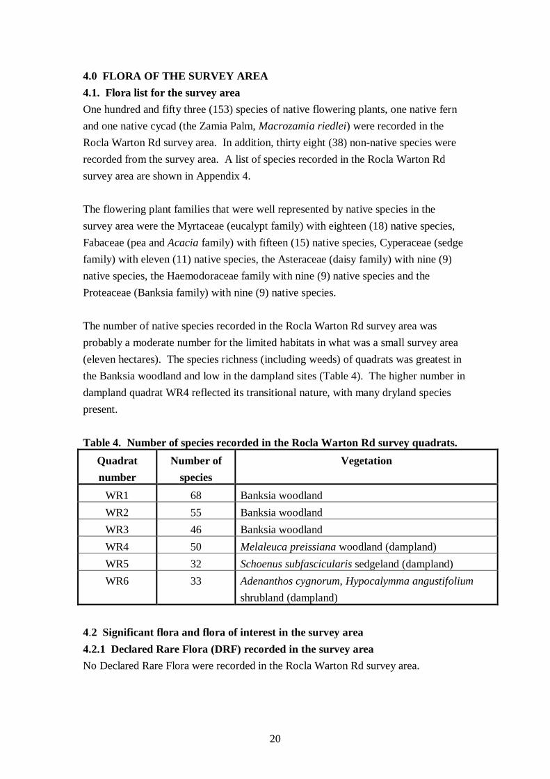
4.0 FLORA OF THE SURVEY AREA 4.1. Flora list for the survey area One hundred and fifty three (153) species of native flowering plants, one native fern and one native cycad (the Zamia Palm, Macrozamia riedlei) were recorded in the Rocla Warton Rd survey area. In addition, thirty eight (38) non-native species were recorded from the survey area. A list of species recorded in the Rocla Warton Rd survey area are shown in Appendix 4. The flowering plant families that were well represented by native species in the survey area were the Myrtaceae (eucalypt family) with eighteen (18) native species, Fabaceae (pea and Acacia family) with fifteen (15) native species, Cyperaceae (sedge family) with eleven (11) native species, the Asteraceae (daisy family) with nine (9) native species, the Haemodoraceae family with nine (9) native species and the Proteaceae (Banksia family) with nine (9) native species. The number of native species recorded in the Rocla Warton Rd survey area was probably a moderate number for the limited habitats in what was a small survey area (eleven hectares). The species richness (including weeds) of quadrats was greatest in the Banksia woodland and low in the dampland sites (Table 4). The higher number in dampland quadrat WR4 reflected its transitional nature, with many dryland species present. Table 4. Number of species recorded in the Rocla Warton Rd survey quadrats.
Quadrat number
Number of species
Vegetation
WR1 68 Banksia woodland WR2 55 Banksia woodland WR3 46 Banksia woodland WR4 50 Melaleuca preissiana woodland (dampland) WR5 32 Schoenus subfascicularis sedgeland (dampland) WR6 33 Adenanthos cygnorum, Hypocalymma angustifolium
shrubland (dampland) 4.2 Significant flora and flora of interest in the survey area 4.2.1 Declared Rare Flora (DRF) recorded in the survey area No Declared Rare Flora were recorded in the Rocla Warton Rd survey area.

21
4.2.2 Priority flora species recorded from the survey area No Priority flora species were recorded in the survey area. 4.2.3 Other species of regional significance recorded in the survey area Two plant species considered to have regional significance in the Rocla Warton Rd survey area, Hensmania turbinata and Pultenaea ochreata, were recorded. 4.2.3.1 Hensmania turbinata Hensmania turbinata is a perennial herb about 20cm high (Paczkowska and Chapman, 2000). It is considered regionally significant in the Perth Metropolitan area because that is about the southern most extent of its range (Department of Environmental Protection, 2000b). Hensmania turbinata was recorded from one location in the survey area, although its exact location was not recorded. 4.2.3.2 Pultenaea ochreata Pultenaea ochreata is an erect shrub that grows to between 30 cm and 2 metres tall, has a pea flower and has been recorded on sandy soils in winter wet depressions (Paczkowska and Chapman, 2000; Plate 1). The Perth Metropolitan area appears to be at the northern limit of Pultenaea ochreata’s range and it would therefore be of regional significance in the Perth area.
Plate 1. Pultenaea ochreata. (Photograph reproduced from FloraBase, Dept of Environment and Conservation website).

22
Pultenaea ochreata was recorded at three locations in the south-east corner of the survey area, near (and including) quadrat WR6. 4.2.4 Other species of interest recorded in the survey area Two taxa recorded in the survey area, Leucopogon sp. Murdoch (M. Hislop 1037) and Hibbertia huegelii sens. lat., were also of interest. Leucopogon sp. Murdoch (M. Hislop 1037) is an erect open shrub growing to a height of 70 to 80 centrimetres (DEC FloraBase website, May 2011; Plate 2). It grows on sand soils on winter wet sites, plains and swamps. Its range includes the Swan Coastal Plain and Geraldton sand plains between Eneaba in the north and Bunbury in the south (Mike Hislop, Western Australian Herbarium, pers. comm.). However, it is scattered sparsely within its range and generally only occurs in small numbers (Mike Hislop, pers. comm.). In its general appearance, without close scrutiny, Leucopogon sp. Murdoch (M. Hislop 1037) may be mistaken for L. propinquus. Leucopogon sp. Murdoch (M. Hislop 1037) was recorded and collected once in the south west corner of the survey area.
Plate 2. Leucopogon sp. Murdoch (M. Hislop 1037). (Photograph reproduced from Flora Base, Dept of Environment and Conservation website).
23
Hibbertia huegelii sens. lat. refers to one collection of Hibbertia huegelii from the survey area that differed from the more common form of H. huegelii by having a dense covering of long hairs on the outer calyx surface as well as on the lower parts of the leaves. Hibbertia huegelii sens. lat. keyed to Hibbertia huegelii and matched some variations of Hibbertia huegelii in the Western Australian Herbarium’s main collection (Mike Hislop, per. comm.). It was collected on the lower dune slopes on the eastern side of the survey area.

24
5.0 VEGETATION OF THE SURVEY AREA 5.1 Vegetation description 5.1.1 Introduction to the vegetation descriptions The vegetation units described are considered to be mostly described at the vegetation association level. The vegetation unit codes that discriminate the mapped vegetation units are derived from the generic and species names of the more abundant genera or species in the different strata present in each unit (see Table 5). For example, the vegetation unit ‘MpAa’ has its code derived from two of the dominant species in that unit: ‘Mp’ (Melaleuca preissiana) and ‘Aa’ (Astartea affinis). Table 5. Abbreviations for species names that were used in vegetation unit codes. Code Species name Code Species name Aa Astartea afinis Ha Hypocalymma angustifolium
Ac Adenanthos cygnorum Mp Melaleuca preissiana Ba Banksia attenuata Pe Pericalymma ellipticum Bm Banksia menziesii Ss Schoenus subfascicularis
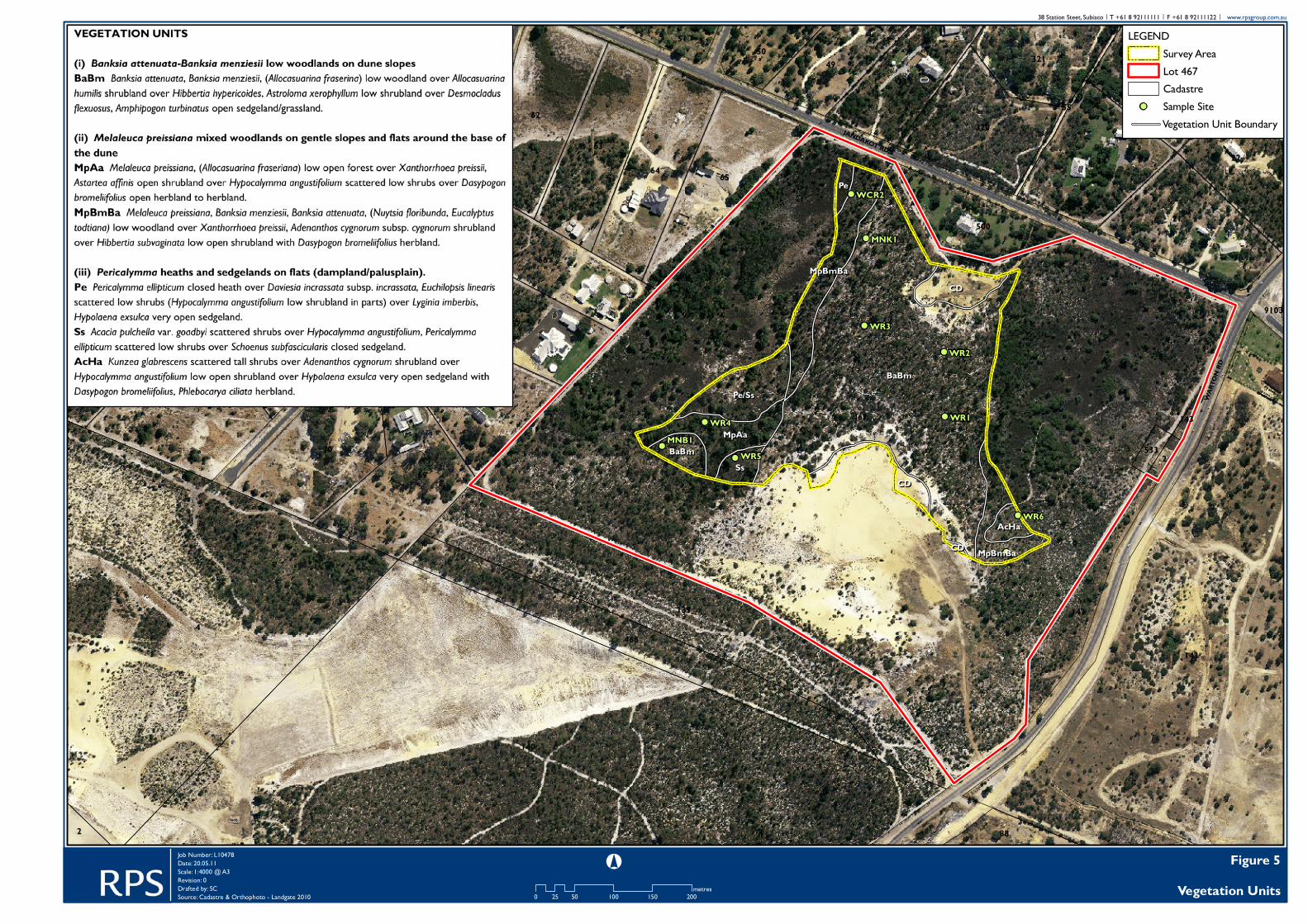
5.1.2 Vegetation of the Rocla Warton Rd survey area 5.1.2.1 Overview Six vegetation units were described and mapped in the remnant bushland in the Rocla Warton Rd survey area (Figure 5). These have been arranged into three vegetation groupings according to habitat in which they occurred:
• Banksia attenuata-Banksia menziesii low woodlands on dune slopes; • Melaleuca preissiana mixed woodlands on gentle slopes and flats around the
base of the dune (transitional vegetation); • Pericalymma heaths and sedgelands on flats (dampland/palusplain).
Banksia attenuata-Banksia menziesii low woodlands covered the dune crest and slopes that occupy most of the survey area (Figure 5). Eucalyptus todtiana occurred in scattered patches across the dune, but occurred more consistently on the lower slopes. Transitional dryland vegetation of mixed woodlands with Melaleuca preissiana scattered low trees occurred along the base of the dune on the western and parts of the eastern edges of the survey area. Transitional wetland vegetation included Melaleuca preissiana low open forests and shrublands of Adenanthos cygnorum and Hypocalymma angustifolium on the flats (included wetland and dryland species).
25
Small areas of Pericalymma ellipticum heath and Schoenus subfascicularis sedgelands (seasonal damplands) occurred in the south-western and north-western corners of the survey area. 5.1.2.2 Vegetation units (i) Banksia attenuata-Banksia menziesii low woodlands on dune slopes BaBm Banksia attenuata, Banksia menziesii, (Allocasuarina fraserina) low woodland over Allocasuarina humilis shrubland over Hibbertia hypericoides, Astroloma xerophyllum low shrubland over Desmocladus flexuosus, Amphipogon turbinatus open sedgeland/grassland. Habitat and soil: Mid to upper slopes of dune. Pale grey sand over yellow sand. Notes: This vegetation was recorded at quadrats WR1, WR2 and WR3 (Plate 3) (details in Appendix 5). Eucalyptus todtiana occurred occasionally on the upper slopes and scattered on the lower slopes. (ii) Melaleuca preissiana mixed woodlands on gentle slopes and flats around the base of the dune MpAa Melaleuca preissiana, (Allocasuarina fraseriana) low open forest over Xanthorrhoea preissii, Astartea affinis open shrubland over Hypocalymma angustifolium scattered low shrubs over Dasypogon bromeliifolius open herbland to herbland. Habitat and soil: North facing, very gently sloping to flat seasonal dampland. Grey sand. Notes: This vegetation was recorded at quadrat WR4 (Plate 4) (details in Appendix 5). It occurred in the south-west corner of the survey area and included dryland species (eg Allocasuarina fraseriana) as well as dampland species (eg Melaleuca preissiana, Baumea juncea). It was considered to be transitional dampland vegetation.
!
!
!
!
!
!
!
!
!
!
BaBmBaBm
Pe/SsPe/Ss
CDCD
MpAaMpAa
SsSsCDCD
MpBmBaMpBmBa
PePe
BaBmBaBm
AcHaAcHa
MpBmBaMpBmBa
CDCD
467
4
140
131
143
139
71
62
69
70
64 65
6334
74
66
67
68
21
73
72
75
35
468
22
33
320
49 321
500
143
50 36
88
23
51
2
2533
55
143
9103
WR6
WR5
WR4
WR3
WR2
WR1
MNK1
MNB1
WCR2
WAR
TON
RD
JANDAKOT RD
SKOT
SCH
RD
Figure 5Vegetation Units0 50 100 150 20025
metres
°Job Number: L10478Date: 20.05.11Scale: 1:4000 @ A3Revision: 0Drafted by: SCSource: Cadastre & Orthophoto - Landgate 2010
38 Station Steet, Subiaco | T +61 8 92111111 | F +61 8 92111122 | www.rpsgroup.com.au
LEGENDSurvey AreaLot 467Cadastre
! Sample SiteVegetation Unit Boundary

27
Plate 3. Banksia attenuata-Banksia menziesii low woodland unit ‘BaBm’ at quadrat WR3.
Plate 4. Vegetation unit ‘MpAa’ at quadrat WR4.
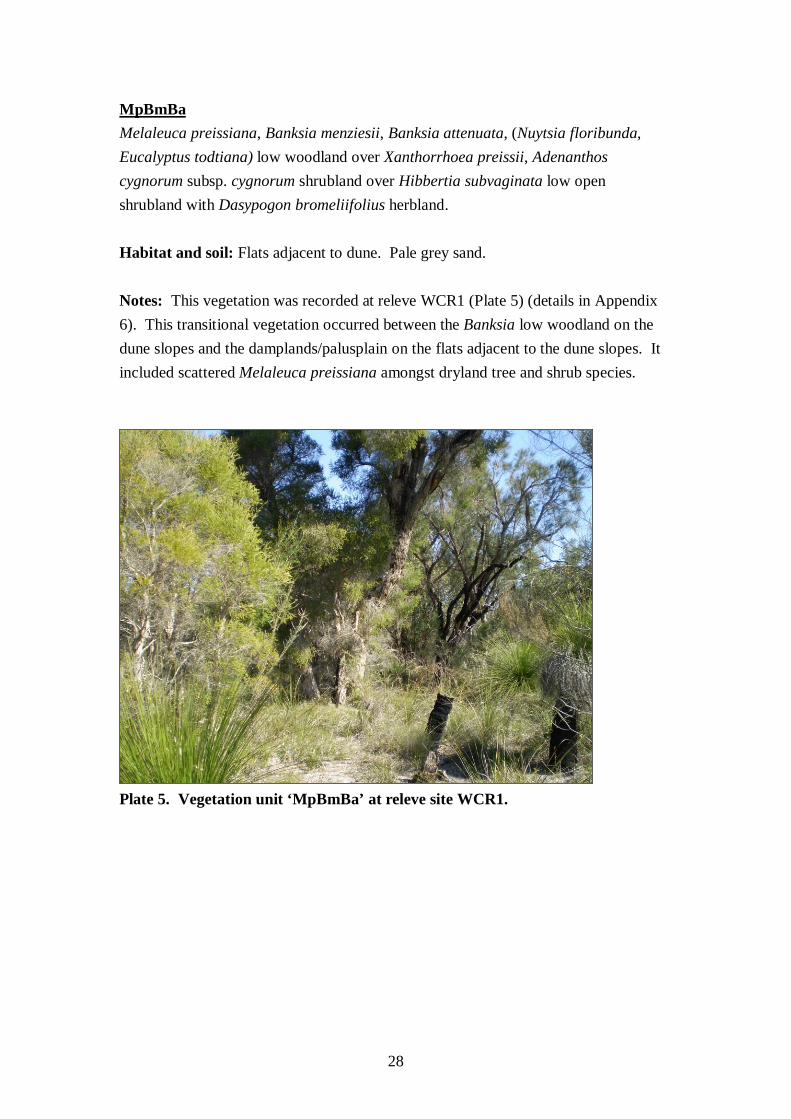
28
MpBmBa Melaleuca preissiana, Banksia menziesii, Banksia attenuata, (Nuytsia floribunda, Eucalyptus todtiana) low woodland over Xanthorrhoea preissii, Adenanthos cygnorum subsp. cygnorum shrubland over Hibbertia subvaginata low open shrubland with Dasypogon bromeliifolius herbland. Habitat and soil: Flats adjacent to dune. Pale grey sand. Notes: This vegetation was recorded at releve WCR1 (Plate 5) (details in Appendix 6). This transitional vegetation occurred between the Banksia low woodland on the dune slopes and the damplands/palusplain on the flats adjacent to the dune slopes. It included scattered Melaleuca preissiana amongst dryland tree and shrub species.
Plate 5. Vegetation unit ‘MpBmBa’ at releve site WCR1.
29
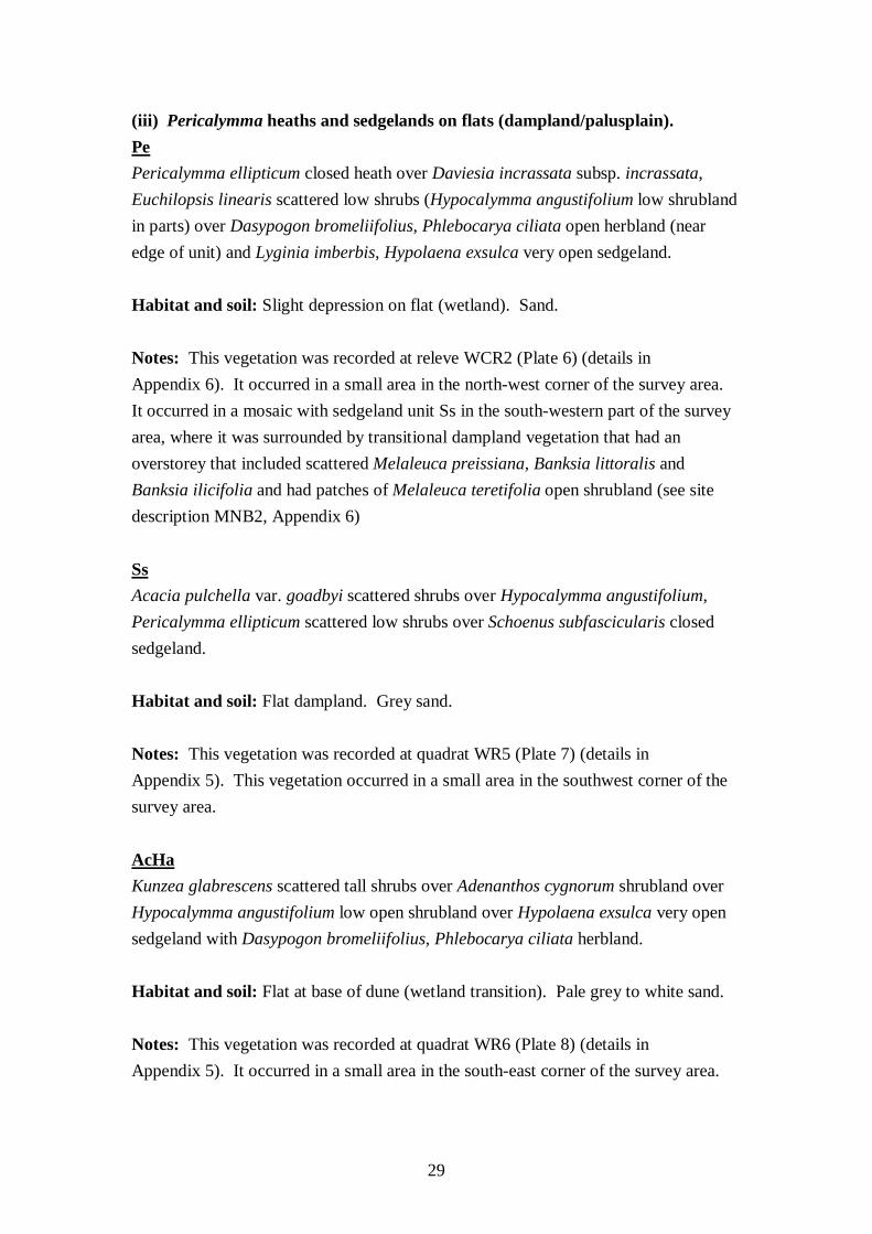
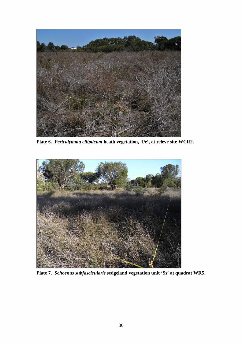
(iii) Pericalymma heaths and sedgelands on flats (dampland/palusplain). Pe Pericalymma ellipticum closed heath over Daviesia incrassata subsp. incrassata, Euchilopsis linearis scattered low shrubs (Hypocalymma angustifolium low shrubland in parts) over Dasypogon bromeliifolius, Phlebocarya ciliata open herbland (near edge of unit) and Lyginia imberbis, Hypolaena exsulca very open sedgeland. Habitat and soil: Slight depression on flat (wetland). Sand. Notes: This vegetation was recorded at releve WCR2 (Plate 6) (details in Appendix 6). It occurred in a small area in the north-west corner of the survey area. It occurred in a mosaic with sedgeland unit Ss in the south-western part of the survey area, where it was surrounded by transitional dampland vegetation that had an overstorey that included scattered Melaleuca preissiana, Banksia littoralis and Banksia ilicifolia and had patches of Melaleuca teretifolia open shrubland (see site description MNB2, Appendix 6) Ss Acacia pulchella var. goadbyi scattered shrubs over Hypocalymma angustifolium, Pericalymma ellipticum scattered low shrubs over Schoenus subfascicularis closed sedgeland. Habitat and soil: Flat dampland. Grey sand. Notes: This vegetation was recorded at quadrat WR5 (Plate 7) (details in Appendix 5). This vegetation occurred in a small area in the southwest corner of the survey area. AcHa Kunzea glabrescens scattered tall shrubs over Adenanthos cygnorum shrubland over Hypocalymma angustifolium low open shrubland over Hypolaena exsulca very open sedgeland with Dasypogon bromeliifolius, Phlebocarya ciliata herbland. Habitat and soil: Flat at base of dune (wetland transition). Pale grey to white sand. Notes: This vegetation was recorded at quadrat WR6 (Plate 8) (details in Appendix 5). It occurred in a small area in the south-east corner of the survey area.
30
Plate 6. Pericalymma ellipticum heath vegetation, ‘Pe’, at releve site WCR2.
Plate 7. Schoenus subfascicularis sedgeland vegetation unit ‘Ss’ at quadrat WR5.

31
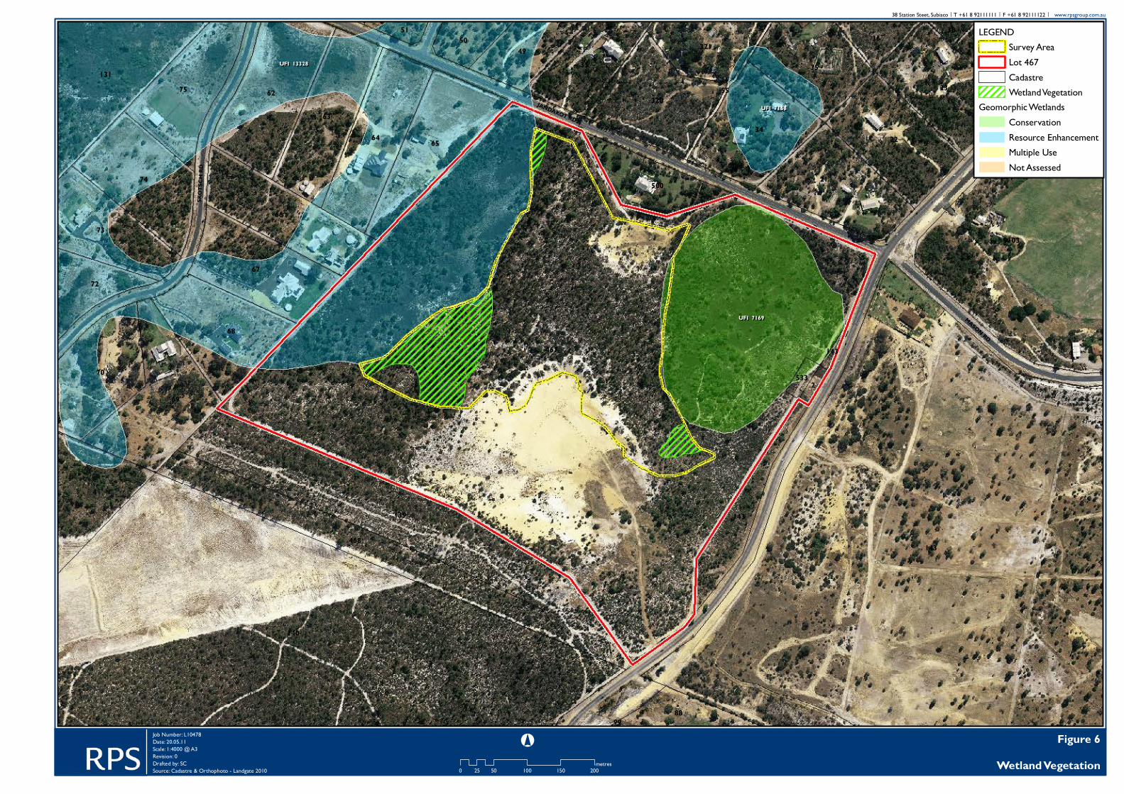
Plate 8. Vegetation unit ‘AcHa’ at quadrat WR6. 5.2 Wetland vegetation The vegetation units described in section 5.1 above are shown in Table 6, together with their wetland status. The location of the wetland vegetation and its boundaries can be seen in Figure 6. The Pericalymma ellipticum heath (‘Pe’) and Schoenus subfascicularis sedgeland (‘Ss’) units were considered to be wetland vegetation (seasonal damplands). These wetlands units occurred on the eastern side of the survey area. Two transitional vegetation units on the flats at the baseof the dune (‘MpAa’ and ‘AcHa’), were deemed to be transitional damplands. ‘MpAa’ was considered to be a transitional dampland because of its relationships with the wetland FCT5 evident in the PATN analysis dendrogram and because it included high cover of the wetland obligate Melaleuca preissiana. ‘AcHa’ was considered to be a transitional dampland because of its affinity to wetland FCT4, demonstrated in the PATN nearest neighbour analysis and because of the presence of some wetland obligate species. Conversely, the transitional vegetation unit ‘MpBmBa’, that occurred on the base of the dune slopes, had mostly dryland elements and was considered to be transitional dryland vegetation.
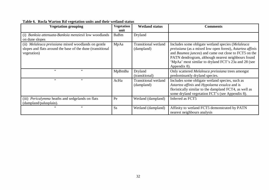
32
Table 6. Rocla Warton Rd vegetation units and their wetland status Vegetation grouping Vegetation
unit Wetland status Comments
(i) Banksia attenuata-Banksia menziesii low woodlands on dune slopes
BaBm Dryland
(ii) Melaleuca preissiana mixed woodlands on gentle slopes and flats around the base of the dune (transitional vegetation)
MpAa Transitional wetland (dampland)
Includes some obligate wetland species (Melaleuca preissiana (as a mixed low open forest), Astartea affinis and Baumea juncea) and came out close to FCT5 on the PATN dendrogram, although nearest neighbours found ‘MpAa’ most similar to dryland FCT’s 23a and 28 (see Appendix 8).
“ “ MpBmBa Dryland (transitional)
Only scattered Melaleuca preissiana trees amongst predominantly dryland species.
“ “ AcHa Transitional wetland (dampland)
Includes some obligate wetland species, such as Astartea affinis and Hypolaena exsulca and is floristically similar to the dampland FCT4, as well as some dryland vegetation FCT’s (see Appendix 8).
(iii) Pericalymma heaths and sedgelands on flats (dampland/palusplain).
Pe Wetland (dampland) Inferred as FCT5
“ “ Ss Wetland (dampland) Affinity to wetland FCT5 demonstrated by PATN nearest neighbours analysis
467
143
140
9103
139
4
62
69
64 65
6334
74
66
67
68
21
22
23
70
75131
468
35
73
2433
320
49
72
500
321
143
88
50 36
2
51 38
533
9101
55
143
99
UFI 13328UFI 13328
UFI 7169UFI 7169
UFI 7168UFI 7168
WARTON RD
JANDAKOT RD
SKOT
SCH
RD
MASON RD
Figure 6Wetland Vegetation
LEGENDSurvey AreaLot 467CadastreWetland Vegetation
Geomorphic WetlandsConservationResource EnhancementMultiple UseNot Assessed
0 50 100 150 20025metres
°Job Number: L10478Date: 20.05.11Scale: 1:4000 @ A3Revision: 0Drafted by: SCSource: Cadastre & Orthophoto - Landgate 2010
38 Station Steet, Subiaco | T +61 8 92111111 | F +61 8 92111122 | www.rpsgroup.com.au

34
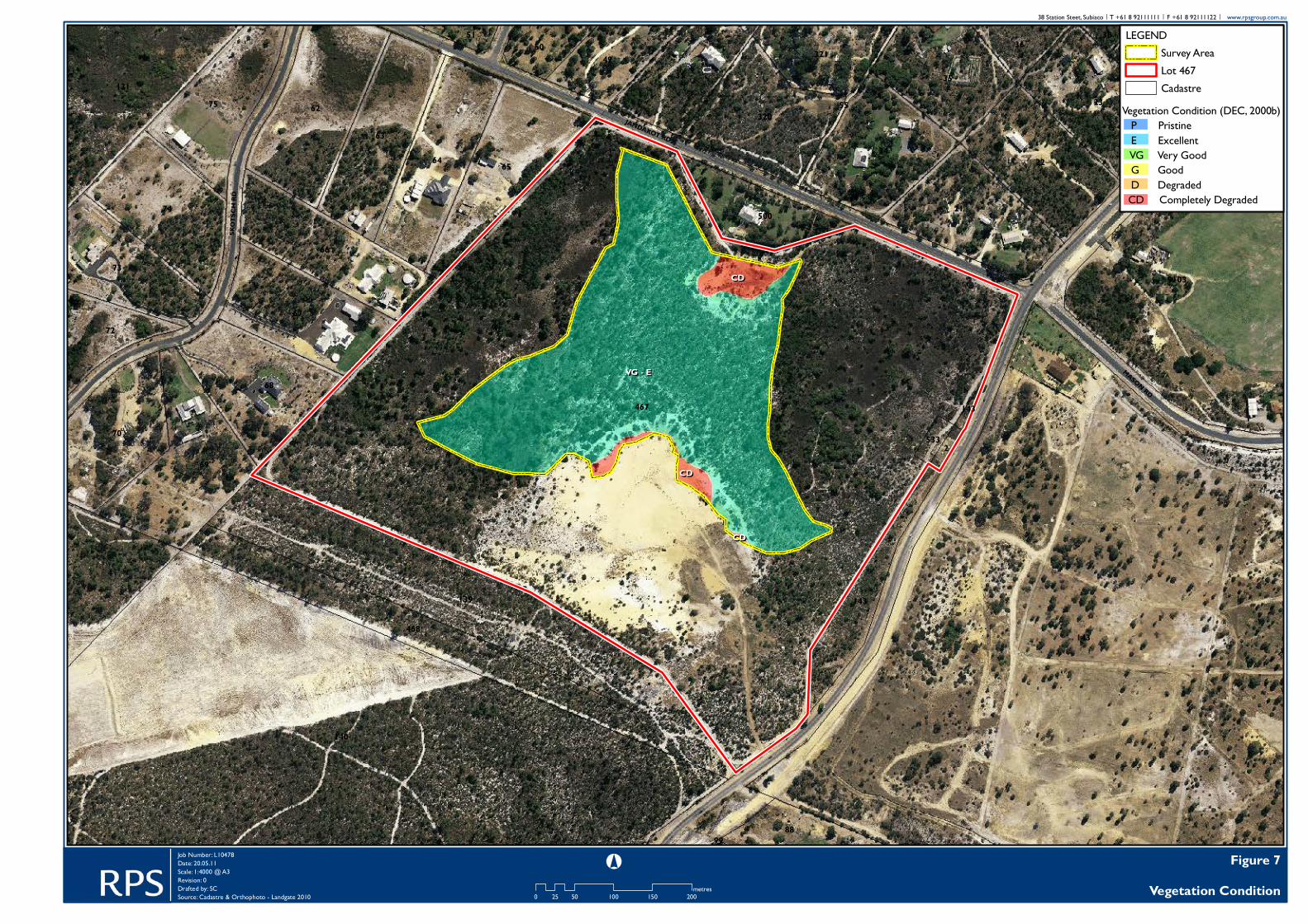
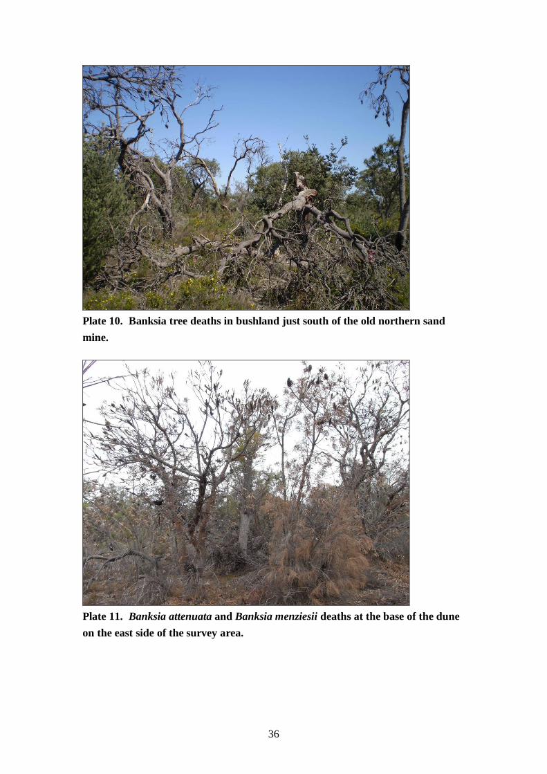
5.3 Vegetation condition The vegetation in the survey area was mostly rated Very Good to Excellent, with the vegetation condition rated Excellent at a number of sample locations on the dunes and flats (Figure 7). The condition of the wetland vegetation was considered to be Very Good to Excellent. Completely Degraded areas in the northern and southern parts of the survey area were past sand mine areas (Plate 9). Thirty eight weeds were recorded in the survey area (Appendix 4). However, weed cover was generally low throughout the remnant bushland in the survey area and were only abundant in the Completely Degraded areas. Banksia spp. deaths, including recent deaths, were noted on the dune slopes in the survey area (Plates 10, 11). Locations of some of the observed areas of Banksia deaths are provided in Appendix 7. The deaths and decline of Banksia trees at this site probably indicate the presence of the Dieback fungus Phytophthera cinnamomi. However, other agents such as fire and drought (including falling water tables), as well as other pathogens, may also be responsible for Banksia tree deaths. To determine if Dieback is present and over what area, a dieback survey by accredited ‘dieback interpreters’ would be required.
Plate 9. Completely Degraded old sand mine area at the northern end of the survey area.
VG - EVG - E
CDCD
CDCD
CDCD
467
143
140
9103
139
4
62
69
64 65
6334
74
66
67
68
21
22
23
70
75131
468
35
73
2433
320
49
72
500
321
143
88
50 36
2
51 38
533
9101
55
143
99
WARTON RD
JANDAKOT RD
SKOT
SCH
RD
MASON RD
Figure 7Vegetation Condition0 50 100 150 20025
metres
°Job Number: L10478Date: 20.05.11Scale: 1:4000 @ A3Revision: 0Drafted by: SCSource: Cadastre & Orthophoto - Landgate 2010
38 Station Steet, Subiaco | T +61 8 92111111 | F +61 8 92111122 | www.rpsgroup.com.au
LEGENDSurvey AreaLot 467Cadastre
Vegetation Condition (DEC, 2000b) P Pristine E Excellent VG Very Good G Good D Degraded CD Completely Degraded
36
Plate 10. Banksia tree deaths in bushland just south of the old northern sand mine.
Plate 11. Banksia attenuata and Banksia menziesii deaths at the base of the dune on the east side of the survey area.

37
5.4 Lomandra hermaphrodita and L. maritima occurrence : host plants of the Graceful Sun Moth The Graceful Sun Moth (Synemon gratiosa, Family Castniidae) is endemic to Western Australia, and is currently considered restricted to the Swan Coastal Plain between the Wanneroo area in northern Perth, south to Mandurah (approximately 60 km south of Perth). The Graceful Sun Moth is listed as under the Environment Protection and Biodiversity Conservation Act 1999 and is also currently listed on Schedule 1 (fauna that is rare or is likely to become extinct) of the Western Australian Wildlife Conservation Act 1950. The Graceful Sun Moth is thought to breed exclusively on Lomandra species, probably L. hermaphrodita. Two known food plants for the Graceful Sun Moth are Lomandra hermaphrodita and L. maritima (McNamara 2009, sited on Department of the Environment, Water, Heritage and the Arts website). Lomandra maritima was not recorded in the Rocla Warton Rd survey area. However, Lomandra hermaphrodita plants were recorded at all three of the quadrats located on the dune slopes. While opportunisitic sightings of Lomandra hermaphrodita plants elsewhere in the site were not recorded during the survey, the fact that it occurred at all three sample points on the dune (less than 2% cover) suggests that it is probably scattered on the dune slopes in the survey area.
38
6.0 FLORISTIC COMMUNITY TYPES (FCT’S), THREATENED ECOLOGICAL COMMUNITIES (TEC’S) AND PRIORITY ECOLOGICAL COMMUNITIES (PEC’S) This section outlines the results of the floristic analysis conducted by Mr Ted Griffin using the 2010 Rocla Warton Rd survey data and the Gibson et al. (1994) Swan Coastal Plain dataset. It is based on a detailed report prepared by Mr Ted Griffin, which is set out in full in Appendix 8. 6.1 Floristic analysis 6.1.1 Data Compatability Mr Ted Griffin assessed that the Rocla Warton Rd survey sites appeared to have similar numbers of ephemeral species (such as Orchids) to those of the Gibson et al. (1994) sites. Further, he concluded that on the basis of richness and names that the datasets were probably sufficiently compatible to obtain reliable determinations (Appendix 8). 6.1.2 Determination of Floristic Community Types (FCT) by classification The dendrogram results of the PATN analysis classification are shown in Appendix 8 and Table 7. This shows that the Rocla Warton Rd sites were divided between the dune sites that were most similar to FCT23a and sites on the flats that were similar to the wetland FCT’s 4 and 5. 6.1.3 Determination of Floristic Community Types (FCT) using nearest neighbours method Griffin found that the the nearest neighbour analysis also suggested that the Rocla Warton Rd dune slope sites belong to FCT23a, but suggested that two of the sites on the flats had affinities to both wetland and dryland FCT’s (see Table 7; Appendix 8). 6.1.4 Combining the results: assignment of Floristic Community Types (FCT) to the Rocla Warton Rd quadrat sites The overall result of the Rocla Warton Rd quadrat PATN analysis is shown in Table 7 below (reproduced from Griffin’s report, see Appendix 8). The dune Banksia woodland vegetation sites were all most similar to Floristic Community Type (FCT) 23a. The Schoenus subfascicularis sedgeland vegetation was consistently similar to FCT5 dampland sites. The Adenanthos cygnorum-Hypocalymma angustifolium shrubland site had mixed affinities, but had strong affinity to dampland FCT4 vegetation. The Melaleuca preissiana low open forest vegetation had some affinity with dampland vegetation FCT5. Both the

39
Melaleuca preissiana low open forest and Adenanthos cygnorum-Hypocalymma angustifolium shrubland vegetation were deemed to be wetland vegetation units because of their PATN floristic affinities and because of the presence and cover of obligate wetland species. In interpreting the PATN analysis results, Griffin noted that “It is common for the classification ‘(dendrogram)’ to indicate a simple result and the nearest neighbour analysis to be less conclusive. This is more a product of the classification process often suggesting an over simplified view than of inconsistency of the analyses” (see Appendix 8). Griffin (pers. comm.) has previously noted that the nearest neighbour analysis is more easily interpreted and reliable than the classification analysis and has given more weight to the nearest neighbour analysis assignment of vegetation sites to FCT’s. Table 7. Summary of Rocla Warton Rd PATN Analysis results. (Adapted from report by EA Griffin which is reproduced in full in Appendix 8). Site Dendrogram FCT NNB FCT Summary FCT WR1 23a 23a 23a WR 2 23a 23a 23a WR 3 23a 23a 23a WR 4 5 23a,28 23a/5 WR 5 5 5 5 WR 6 4 4,22,23a 4? (4/22)
6.2 Rocla Warton Rd vegetation units, their Floristic Community Types and assessment for Threatened Ecological Communities (TEC’s) and Priority Ecological Communities (PEC’s) The vegetation units described and mapped in the Rocla Warton Rd survey area are listed in Table 8, together with the quadrats recorded in those units and the FCT’s attributed by PATN analysis (and in some cases inferred) to those sites. FCT’s were inferred to the vegetation units by comparison with other floristically similar Rocla Warton Rd vegetation units where quadrats had been recorded or by comparing species in site descriptions with species occurring in the Gibson et al. FCT’s. All of the FCT’s with which Rocla Warton Rd vegetation units were found to have an affinity, are listed in Table 9, along with their descriptions, predominant landforms and status. Referrence to the current list of TEC’s for Western Australia (DEC

40
website Aug 2010) showed that none of the FCT’s occurring in the survey area were Threatened Ecological Community. One vegetation unit, ‘AcHa’, had some affinity with FCT22, which is a Priority 2 PEC (Tables 8 and 9). Table 8. Summary of Rocla Warton Rd survey area vegetation units and FCT’s. Mapped Vegtn unit
Broad classification Site FCTz
AcHa Pericalymma heaths and sedgelands on flats (dampland/palusplain).
WR6 4/22
BaBm Banksia attenuata-Banksia menziesii low woodlands on dune slopes
WR1, WR2, WR3
23a
MpAa
Melaleuca preissiana mixed woodlands and mixed shrublands on gentle slopes and flats around the base of the dune (transitional vegetation)
WR4 23a/5
MpBmBa
Melaleuca preissiana mixed woodlands and mixed shrublands on gentle slopes and flats around the base of the dune (transitional vegetation)
WCR1, MNK1 23az
Pe Pericalymma heaths and sedgelands on flats (dampland/palusplain).
WCR2, MNB2 5z
Ss Pericalymma heaths and sedgelands on flats (dampland/palusplain).
WR5 5
z FCTs inferred. Table 9. Summary of Floristic Community Types occurring in the Rocla Warton Rd survey area. FCT Generalised description Predominant landform Status FCT4 Melaleuca preissiana damplands Bassendean none FCT5 Mixed shrub damplands Bassendean/Pinjarra
plain none
FCT22 Banksia ilicifolia woodlands Bassendean PEC (Priority 2)
FCT23a Central Banksia attenuata-Banksia menziesii woodlands
Bassendean none

41
7.0 REGIONAL SIGNIFICANCE ASSESSMENT Flora and vegetation values in the Rocla Warton Rd survey area were assessed for regional significance (Table 10) using the criteria for determination of regional significance of natural areas set out in the EPA Guidance Statement No. 10 (Environmental Protection Authority, 2006) and Bush Forever (Department of Environmental Protection, 2000a). The Rocla Warton Rd survey area was assessed as regionally significant for flora and vegetation on the following grounds (see Table 10):
• Representation of ecological communities (less than 10% of Southern River Complex is protected (Department of Environmental Protection, 2000b)); and
• Maintaining linkages (part of a ‘regionally significant but not contiguous linkage of bushland/wetland area’) (Department of Environmental Protection, 2000b).
The vegetation in the Rocla Warton Rd survey area is Southern River Complex, of which 17% of its original extent in the Perth Metropolitan area remains, but about 6% of this original extent has some existing protection (Department of Environmental Protection, 2000a). The Department of Environment and Conservation has a modified objective for Constrained Areas being to seek to: • retain at least 10% of the pre-clearing extent of the ecological community where >10% of the ecological community remains, or • retain all remaining areas of each ecological community where <10% of this ecological community remains. (Environmental Protection Authority, 2006) It was also noted that bushland in the survey area was part of an area of ‘upland and wetland’ ecological communities. The Rocla Warton Rd survey area is part of a north-south orientated bushland corridor between Gibbs Rd and Jandakot Airport/Canningvale bushland that has been assigned the status of ‘Regionally significant but not contiguous linkage of bushland/wetland areas’ (Department of Environmental Protection, 2000b). It is noted that the Rocla Warton Rd survey area includes a narrow strip along the edge of a Conservation Category Wetland along its eastern boundary (Figures 4 and 5). The vegetation in this part of Conservation Category Wetland has been checked and confirmed as dryland vegetation adjacent to wetland vegetation outside the survey area.
42
Table 10. Regional Significance Assessment: Rocla Warton Rd Criterion Comment
(i) Representation of ecological communities
Vegetation complexes BushForever (SCP part of PMA) (DEP, 2000a): Southern River Complex: 17%of original area remaining; 6% existing protection, 10% proposed BF protection. System6+part System 1 (EPA, 2006): Southern River Complex: 19.8% of pre-1750 extent; 1.5% in reserve
Floristic community types Affinity to 4 FCTs Size and shape Fairly small area of remnant bushland within larger area of bushland. Uplands and wetlands Wetlands and adjacent upland vegetation is present in the survey area. Vegetation condition Remnants mostly in Very Good to Excellent condition. Dieback is most likely
present in the survey area, but plant deaths do not appear to have been broad scale, with the exception of small areas of recent deaths that were observed.
Conclusion • Southern River Complex have less than 10% of original extent in reserve = Regionally Significant.
(ii) Diversity Vegetation Complexes One Complex (Southern River), although very close to the western edge of
Bassendean Central and South Complex. FCT’s Vegetation units mainly group with 4 FCT’s. Vegetation units Six vegetation units (some wetland units only small area). One dryland unit, 1
dryland (transitional) unit, 1 wetland unit and 2 wetland (transitional) vegetation units and 2 wetland units.
Flora 155 native plant species recorded. Moderate number for size of area (11 hectares). Species richness: dampland quadrats had lower species richness (32 spp. incl. weeds); Banksia woodland had moderate to high species richness (46-68). Transitional dampland sites had higher species counts due to their transitional nature (dryland specie also found there.)
Conclusion Moderate values for diversity (iii) Rarity Flora No DRF. No Priority species. Two other species of regional significance. Vegetation :TEC’s No Tec’s.
One vegetation unit had mixed affinity that included a secondary affinity to PEC (FCT22). This vegetation units only covered a small area.
Conclusion: Moderate values for rare vegetation. (iv) Maintaining ecological processes
Linkage Rocla Warton Rd survey area lies in a north-south bushland corridor between Gibbs Rd and Jandakot airport/Canningvale bushlands that has been deemed ‘Regionally significant but not contiguous linkage of bushland/wetland areas’ (DEP, 2000b).
Size of areas in natural condition
Remnant area covers most of survey area, which is a little greater than 10 hectares in size.
Conclusion: Regionally significant for maintaining linkages. (v) Scientific or evolutionary importance
No known scientific or evolutionary importance.
(vi) General criteria for protection of wetland, streamline, estuarine
Wetland vegetation was recorded in the survey area (Very Good to Excellent condition), but is not classified as ‘conservation category wetland’ A small strip of a conservation wetland along the eastern boundary was inside the survey area. However, the actual vegetation inside the boundary was ‘dryland vegetation’.
Conclusion: Summary: Regionally significant for:
• representation of ecological communities and • for maintaining linkages
43
8.0 ACKNOWLEDGEMENTS Field work was coordinated by Carrie Gill (RPS). Quadrat recording and rare flora searching was undertaken by Carrie Gill, Kelli McCreery and Brian Morgan. Carrie Gill did the vegetation unit and vegetation condition mapping in the field. Plant identifications were mostly undertaken by Brian Morgan and Chris Hancock, with some assistance from Cate Tauss. Mike Hislop (Western Australian Herbarium) undertook a few difficult identifications, Allen Lowrie identified some of the Drosera and Stylidium specimens and Russell Barrett identified the Lepidosperm’s. Mr Ted Griffin ran the PATN analysis and gave advice on the interpretation of the results. His report is included in full in Appendix 8. Simon Croft (RPS) prepared the GIS mapping for the report.

44
9.0 REFERENCES Aplin, T.E.H. (1979) 'The Flora' IN: Environment and Science, B.J. O'Brien (ed.). University of WA Press, Perth. Balla, S. (1994). Wetlands of the Swan Coastal Plain. Vol. 1. Their Nature and Management. Water Authority of Western Australia, Perth. Beard, J. S. (1980). A new phytogeographic map of Western Australia. Western Australian Herbarium Research Notes 3, 37-58. Brown, A., Dundas, P., Dixon, K. and Hopper, S. (2008). “Orchids of Western Australia. University of Western Australia Press. 421p. Churchwood, H. M. and McArthur, W. M. (1980). Landforms and soils of the Darling System, Western Australia. In Atlas of Natural Resources Darling System Western Australia. Dept of Conservation and Environment. University of Western Australia Press. Department of Environmental Protection. (2000a). Bush Forever Vol. 1 Policies, Principals and Processes. Dept of Environmental Protection, Perth. Department of Environmental Protection (2000b) Bush Forever Vol. 2 Directory of Bush Forever Sites. Dept of Environmental Protection, Perth. English, V., and Blyth, J. (1997) Identifying and conserving threatened ecological communities (TECs) in the South West Botanical Province. ANCA National Reserves System Cooperative Program: Project Number N702, Australian National Conservation Agency, Canberra. Environmental Protection Authority. (2004). Guidance for the Assessment of Environmental Factors (in accordance with the Environmental Protection Act 1986). Terrestial Flora and Vegetation Surveys for Environmental Impact Assessment in Western Australia No. 51. June 2004. Western Australia.

45
Environmental Protection Authority. (2006). Guidance for the Assessment of Environmental Factors Western Australia (in accordance with the Environmental Protection Act 1986). Level of Assessment for Proposals Affecting Natural Areas Within the System 6 Region and Swan Coastal Plain Portion of the System 1 Region. No. 10. June 2006. Gibson, N., Keighery, B.J., Keighery, G.J., Burbidge, A.H., and Lyons, M.N. (1994) A Floristic Survey of the Southern Swan Coastal Plain. Unpublished report for the Australian Heritage Commission prepared by the Department of Conservation and Land Management and the Conservation Council of Western Australia (Inc). Griffin, T. and Trudgen, M. (2004). Floristic analysis of quadrat data from remnant native vegetation at Pearce RAAF Airbase. (Unpublished report prepared for Ecoscape (Australia) Pty Ltd). Heddle, E.M., Loneragan, O.W., and Havel, J.J. (1980) 'Vegetation complexes of the Darling System, Western Australia.' In: Atlas of Natural Resources, Darling System Western Australia., M.J. Mulcahy (ed.) pp37-76 and accompanying map. Department of Conservation and Environment, Perth. Hill, A. L., Semeniuk, C. A., Semeniuk, V., Del Marco, A. (1996). Wetlands of the Swan Coastal Plain. Vol. 2A. Wetland Mapping, Classification and Evaluation, Main Report. Water and Rivers Commission, Perth. Marchant, N. G., Wheeler, J. R., Rye, B. L., Bennett, E. M., Lander, N. S., and Macfarlane, T. D. (1987). “Flora of the Perth Region. Parts 1, 2. Western Australian Herbarium. McArthur, W. M. and Bettenay, E. (1960). The development and distribution of the soils of the Swan Coastal Plain, Western Australia. Soil Publication No. 16. CSIRO. Melbourne. Paczkowska, G. and Chapman, A. R. (2000). The Western Australian Flora. A Descriptive Catalogue. Western Australian Herbarium (DEC). 652p. Smith, M. G. (2010). ‘Declared Rare and Priority Flora List for Western Australia’. Department of Environment and Conservation.

46
Trudgen, M. (1999). A flora and vegetation survey of Lots 46 and 47 Maralla Road and Lexia Avenue, Ellenbrook. Unpublished report prepared by M.E.Trudgen and Associates for The Crown Solicitors Office, Government of Western Australia. Water and Rivers Commission. (1997). Native vegetation of freshwater rivers and creeks in south Western Australia. Freshwater. Wheeler, J., Marchant, N. and Lewington, M. (2002). “Flora of the South West. Vols. 1, 2”. UWA Press.

47
APPENDIX ONE. The Department of Environment and Conservation Declared Rare Flora and Priority Flora Categories (from Smith, 2010) Declared Rare Flora - Extant Taxa Taxa which have been adequately searched for and are deemed to be in the wild either rare, in danger of extinction, or otherwise in need of special protection, and have been gazetted as such. Declared Rare Flora - Presumed Extinct Flora Taxa which have not been collected, or otherwise verified, over the past 50 years despite thorough searching, or of which all known wild populations have been destroyed more recently, and have been gazetted as such. Priority One - Poorly Known Taxa. Taxa which are known from one or a few (generally < 5) populations which are under threat, either due to small population size, or being on lands under immediate threat, e.g. road verges, urban areas, farmland, active mineral leases, etc., or the plants are under threat, e.g. from disease, grazing by feral animals, etc. May include taxa with threatened populations on protected lands. Such taxa are under consideration for declaration as 'rare flora', but are in urgent need of further survey. Priority Two - Poorly Known Taxa. Taxa which are known from one or a few (generally < 5) populations, at least some of which are not believed to be under immediate threat (ie. not currently endangered). Such taxa are under consideration for declaration as "rare flora", but are in urgent need of further survey. Priority Three - Poorly Known Taxa. Taxa which are known from several populations, and the taxa are not believed to under immediate threat (i.e. not currently endangered), either due to the number of known populations (generally > 5), or known populations being large, and either widespread or protected. Such taxa are under consideration for declaration as 'rare flora' but are in need of further study. Priority Four - Rare Taxa. Taxa which are considered to have been adequately surveyed and which, whilst being rare (in Australia), are not currently threatened by any identifiable factors. These taxa require monitoring every 5-10 years.
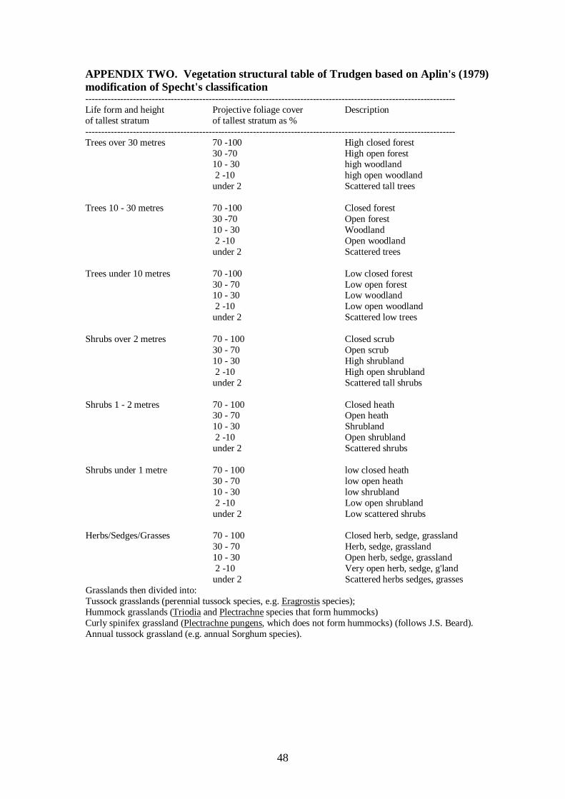
48
APPENDIX TWO. Vegetation structural table of Trudgen based on Aplin's (1979) modification of Specht's classification --------------------------------------------------------------------------------------------------------------------- Life form and height Projective foliage cover Description of tallest stratum of tallest stratum as % --------------------------------------------------------------------------------------------------------------------- Trees over 30 metres 70 -100 High closed forest 30 -70 High open forest 10 - 30 high woodland 2 -10 high open woodland under 2 Scattered tall trees Trees 10 - 30 metres 70 -100 Closed forest 30 -70 Open forest 10 - 30 Woodland 2 -10 Open woodland under 2 Scattered trees Trees under 10 metres 70 -100 Low closed forest 30 - 70 Low open forest 10 - 30 Low woodland 2 -10 Low open woodland under 2 Scattered low trees Shrubs over 2 metres 70 - 100 Closed scrub 30 - 70 Open scrub 10 - 30 High shrubland 2 -10 High open shrubland under 2 Scattered tall shrubs Shrubs 1 - 2 metres 70 - 100 Closed heath 30 - 70 Open heath 10 - 30 Shrubland 2 -10 Open shrubland under 2 Scattered shrubs Shrubs under 1 metre 70 - 100 low closed heath 30 - 70 low open heath 10 - 30 low shrubland 2 -10 Low open shrubland under 2 Low scattered shrubs Herbs/Sedges/Grasses 70 - 100 Closed herb, sedge, grassland 30 - 70 Herb, sedge, grassland 10 - 30 Open herb, sedge, grassland 2 -10 Very open herb, sedge, g'land under 2 Scattered herbs sedges, grasses Grasslands then divided into: Tussock grasslands (perennial tussock species, e.g. Eragrostis species); Hummock grasslands (Triodia and Plectrachne species that form hummocks) Curly spinifex grassland (Plectrachne pungens, which does not form hummocks) (follows J.S. Beard). Annual tussock grassland (e.g. annual Sorghum species).

49
APPENDIX THREE. Vegetation condition scale and descriptions (from Keighery 1994, reproduced in Department of Environmental Protection 2000b) Pristine (1) : Pristine or nearly so, no obvious signs of disturbance Excellent (2) : Vegetation structure intact, disturbance affecting individual species and weeds are
non-aggressive species. Very Good (3) : Vegetation structure altered, obvious signs of disturbance. For example,
disturbance to vegetation structure caused by repeated fires, the presence of some more aggressive weeds, dieback, logging and grazing.
Good (4) : Vegetation structure significantly altered by very obvious signs of multiple disturbance.
Retains basic vegetation structure or ability to regenerate it. For example, disturbance to vegetation structure caused by very frequent fires, the presence of some very aggressive weeds at high density, partial clearing, dieback and grazing.
Degraded (5) : Basic vegetation structure severely impacted by disturbance. Scope for
regeneration but not to a state approaching good condition without intensive management. For example, disturbance to vegetation structure caused by very frequent fires, the presence of very aggressive weeds, partial clearing, dieback and grazing.
Completely Degraded (6) : The structure of the vegetation is no longer intact and the area is
completely or almost completely without native species. These areas are often described as 'parkland cleared' with the flora comprising weed or crop species with isolated native trees or shrubs.

50
APPENDIX FOUR Flora list for the Rocla Warton Rd survey area Notes: 1. Plant families are listed in alphabetical order within the main classification groups. 2. An asterisk (*) beside the taxon name indicates an introduced species not native to the survey area.. 4. The ‘status’ column shows the conservation status of significant flora species on the list. DRF = Declared Rare Flora; P1 to P4 = Priority 1 to Priority 4 (see definitions in Appendix 1); RS = other regionally significant flora FAMILY/TAXA COMMON PRIORITY NAMES STATUS PTERIDOPHYTA (ferns and fern allies) CLASS LYCOPSIDA (fern allies) SELAGINELLACEAE Selaginella gracillima GYMNOSPERMAE CLASS CYCADOPSIDA (Cycads) ZAMIACEAE Macrozamia riedlei Zamia ANGIOSPERMAE (flowering plants) AIZOACEAE *Carpobrotus edulis pigface APIACEAE Trachymene pilosa Xanthosia huegelii ARACEAE *Zantedeschia aethiopica Arum lily ASPARAGACEAE *Asparagus asparagoides Bridle creeper Chamaescilla corymbosa Laxmannia ramosa subsp. ramosa Laxmannia squarrosa Thysanotus manglesianus/patersonii Thysanotus tenellus ASTERACEAE *Arctotheca calendula Capeweed Brachyscome iberidifolia *Hedypnois rhagadioloides subsp. cretica Hyalosperma cotula

51
FAMILY/TAXA COMMON PRIORITY NAMES STATUS ASTERACEAE (cont) *Hypochaeris glabra Lagenophora huegelii Podotheca angustifolia Podotheca chrysantha Podotheca gnaphalioides Quinetia urvillei Rhodanthe citrina Siloxerus humifusus *Sonchus oleraceus *Ursinia anthemoides BORAGINACEAE *Echium plantagineum CACTACEAE *Opuntia stricta Prickly pear CAMPANULACEAE *Wahlenbergia capensis Wahlenbergia preissii CASUARINACEAE Allocasuarina fraseriana Sheoak Allocasuarina humilis CENTROLEPIDACEAE Centrolepis drummondiana COLCHICACEAE Burchardia congesta Wurmbea sp. CRASSULACEAE Crassula colorata var. colorata CYPERACEAE Baumea juncea Baumea vaginalis *Isolepis marginata Lepidosperma longitudinale Lepidosperma scabrum (Inland form) Lepidosperma sp. (formerly L. pubisquameum) Lepidosperma sp. Coastal Dunes (formerly L. pubisquameum) Lepidosperma sp. K Boorabbin (K.L. Wilson 2579) (formerly L. pubisquameum)
52
FAMILY/TAXA COMMON PRIORITY NAMES STATUS CYPERACEAE (cont) Mesomelaena pseudostygia Schoenus clandestinus Schoenus curvifolius Schoenus subfascicularis DASYPOGONACEAE Calectasia narragara Dasypogon bromeliifolius Lomandra caespitosa Lomandra hermaphrodita Lomandra preissii Lomandra suaveolens DILLENIACEAE Hibbertia aurea Hibbertia huegelii Hibbertia huegelii sens. lat. Hibbertia hypericoides
Hibbertia racemosa Hibbertia subvaginata Hibbertia vaginata DROSERACEAE Drosera erythrorhiza subsp. erythrorhiza Drosera glanduligera Drosera menziesii subsp. penicillaris Drosera paleacea Drosera pallida ERICACEAE Astroloma xerophyllum Conostephium pendulum Leucopogon conostephioides Leucopogon sp. Murdoch (M. Hislop 1037) EUPHORBIACEAE *Euphorbia peplus Monotaxis occidentalis Poranthera microphylla

53
FAMILY/TAXA COMMON PRIORITY NAMES STATUS FABACEAE Acacia applanata Acacia huegelii *Acacia longifolia Sydney Golden wattle Acacia pulchella var. goadbyi Acacia stenoptera Bossiaea eriocarpa Daviesia incrassata subsp. incrassata Daviesia triflora Euchilopsis linearis Gastrolobium capitatum Gompholobium tomentosum Hardenbergia comptoniana Hovea trisperma Jacksonia furcellata Kennedia prostrata Pultenaea ochreata *Trifolium arvense GERANIACEAE *Erodium botrys *Pelargonium capitatum GOODENIACEAE Dampiera linearis Lechenaultia floribunda Scaevola repens var. repens HAEMODORACEAE Anigozanthos humilis Anigozanthos manglesii subsp. manglesii Red and Green kangaroo paw Conostylis aculeata subsp. aculeata Conostylis aculeata subsp. preissii Conostylis aurea Conostylis juncea Haemodorum spicatum Phlebocarya ciliata Phlebocarya filifolia HALORAGACEAE Gonocarpus pithyoides
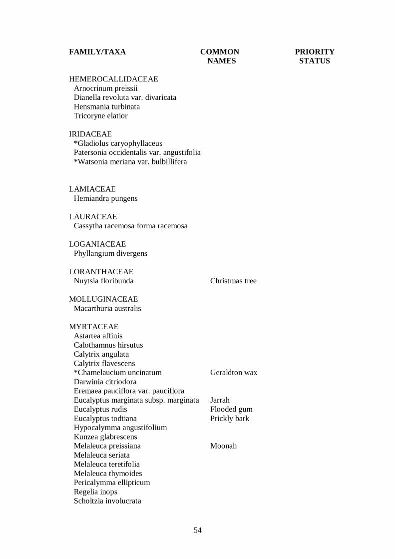
54
FAMILY/TAXA COMMON PRIORITY NAMES STATUS HEMEROCALLIDACEAE Arnocrinum preissii Dianella revoluta var. divaricata Hensmania turbinata Tricoryne elatior IRIDACEAE *Gladiolus caryophyllaceus Patersonia occidentalis var. angustifolia *Watsonia meriana var. bulbillifera LAMIACEAE Hemiandra pungens LAURACEAE Cassytha racemosa forma racemosa LOGANIACEAE Phyllangium divergens LORANTHACEAE Nuytsia floribunda Christmas tree MOLLUGINACEAE Macarthuria australis MYRTACEAE Astartea affinis Calothamnus hirsutus Calytrix angulata Calytrix flavescens *Chamelaucium uncinatum Geraldton wax Darwinia citriodora Eremaea pauciflora var. pauciflora Eucalyptus marginata subsp. marginata Jarrah Eucalyptus rudis Flooded gum Eucalyptus todtiana Prickly bark Hypocalymma angustifolium Kunzea glabrescens Melaleuca preissiana Moonah Melaleuca seriata Melaleuca teretifolia Melaleuca thymoides Pericalymma ellipticum Regelia inops Scholtzia involucrata

55
FAMILY/TAXA COMMON PRIORITY NAMES STATUS ORCHIDACEAE Caladenia discoidea Caladenia flava subsp. flava Cowslip orchid Eriochilus dilatatus subsp. multiflorus White bunny orchid Pterostylis sanguinea Dark banded greenhood orchid Pterostylis sp. Pyrorchis nigricans Thelymitra sp. OXALIDACEAE *Oxalis pes-caprae Sour sob PAPAVERACEAE *Fumaria capreolata POACEAE *Aira caryophyllea Amphipogon turbinatus Aristida contorta Austrostipa elegantissima Austrodanthonia occidentalis Austrostipa flavescens Austrostipa camplachne *Avena barbata *Brachypodium distachyon *Briza maxima *Briza minor *Cynodon dactylon couch *Ehrharta calycina Perennial veldt grass *Ehrharta longiflora Annual veldt grass *Eragrostis curvula Love grass *Holcus lanatus *Lagurus ovatus Microlaena stipoides var. stipoides *Pentaschistis airoides subsp. airoides *Vulpia bromoides *Vulpia myuros forma myuros PORTULACACEAE Calandrinia corrigioloides PRIMULACEAE * Lysimachia arvensis formerly Anagalis arvensis
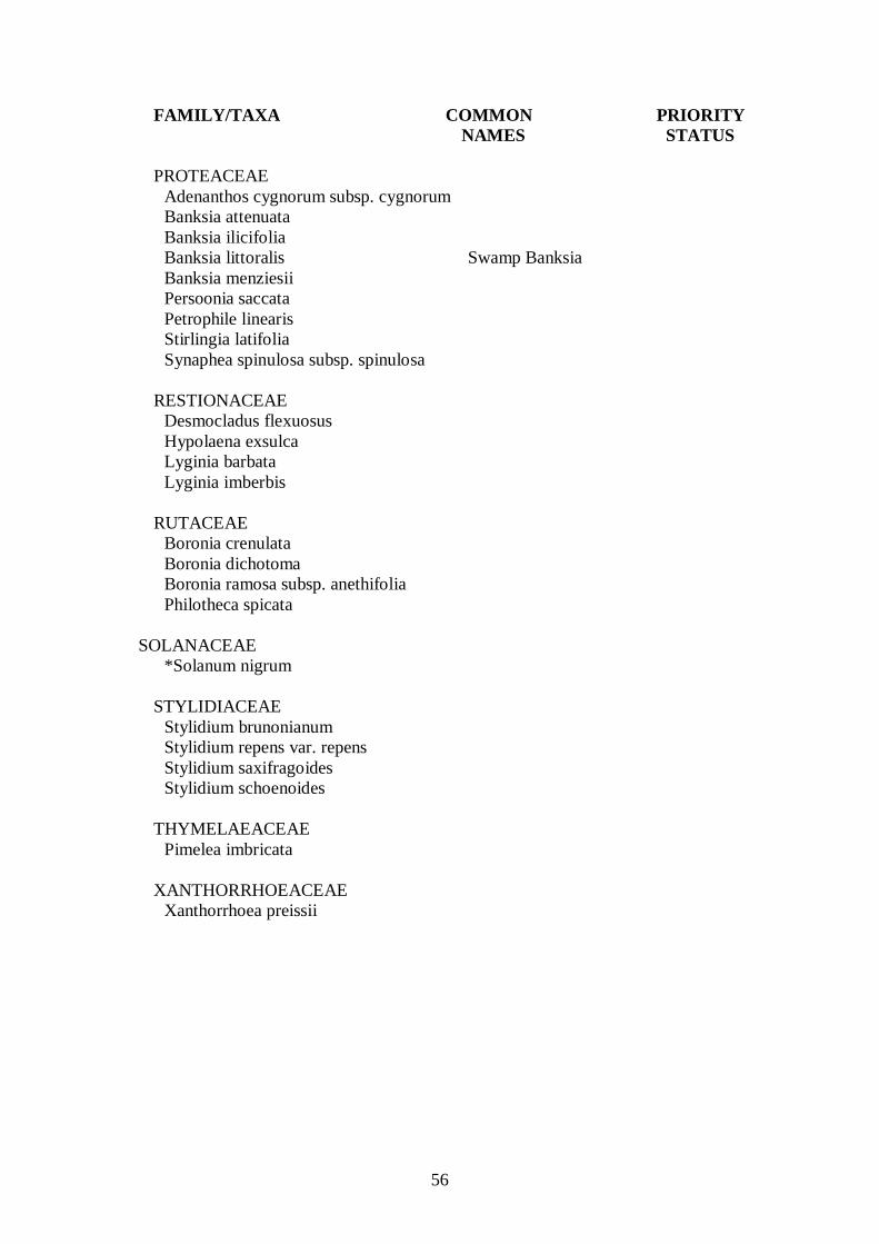
56
FAMILY/TAXA COMMON PRIORITY NAMES STATUS PROTEACEAE Adenanthos cygnorum subsp. cygnorum Banksia attenuata Banksia ilicifolia Banksia littoralis Swamp Banksia Banksia menziesii Persoonia saccata Petrophile linearis Stirlingia latifolia Synaphea spinulosa subsp. spinulosa RESTIONACEAE Desmocladus flexuosus Hypolaena exsulca Lyginia barbata Lyginia imberbis RUTACEAE Boronia crenulata Boronia dichotoma Boronia ramosa subsp. anethifolia Philotheca spicata SOLANACEAE *Solanum nigrum STYLIDIACEAE Stylidium brunonianum Stylidium repens var. repens Stylidium saxifragoides Stylidium schoenoides THYMELAEACEAE Pimelea imbricata XANTHORRHOEACEAE Xanthorrhoea preissii
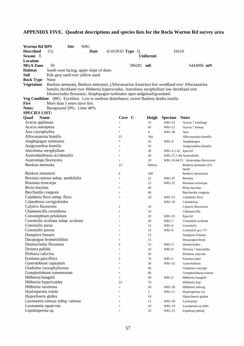
57
APPENDIX FIVE. Quadrat descriptions and species lists for the Rocla Warton Rd survey area Warton Rd RPS Site WR1 Described CG Date 6/10/2010 Type Q 10x10 Season E Uniformit Location MGA Zone 50 396281 mE 6444986 mN Habitat South-west facing, upper slope of dune. Soil Pale grey sand over yellow sand. Rock Type None Vegetation Banksia attenuata, Banksia menziesii, (Allocasuarina fraserina) low woodland over Allocasuarina humilis shrubland over Hibbertia hypericoides, Astroloma xerophyllum low shrubland over Desmocladus flexuosus, Amphipogon turbinatus open sedgeland/grassland. Veg Condition (BF). Excellent. Low to medium disturbance; recent Banksia deaths nearby. Fire More than 5 years since fire. Notes Bareground 20%. Litter 40%. SPECIES LIST: Quad Name Cove C Heigh Specime Notes Acacia applanata + 35 WR1-33 Acacia ? wind/app Acacia stenoptera + 45 WR1-21 Acacia ? stenop Aira caryophyllea + 4 WR1-38 Aira Allocasuarina humilis 23 160 Allocasuarina humilis Amphipogon turbinatus 7 35 WR1-4 Amphipogon Anigozanthos humilis + 10 Anigozanthos humilis Astroloma xerophyllum + 30 WR1-1,1-41 Epacrid Austrodanthonia occidentalis + 30 WR1-27,1-46 Austrodanth Austrostipa flavescens + 20 WR1-10,44.51 Austrostipa flavescens Banksia attenuata 15 600cm Banksia attenuata (2% dead) Banksia menziesii 6 500 Banksia menziessii Boronia ramosa subsp. anethifolia + 25 WR1-47 Boronia Bossiaea eriocarpa + 12 WR1-22 Bossiaea eriocarpa Briza maxima + 40 Briza maxima Burchardia congesta + 40 Burchardia congesta Caladenia flava subsp. flava + 20 WR1-13 Caladenia flava Calandrinia corrigioloides WR1-39 Calandrinia Calytrix flavescens 2 20 Calytrix flavescens Chamaescilla corymbosa + 10 Chamaescilla Conostephium pendulum + 20 WR1-35 Epacrid Conostylis aculeata subsp. aculeata + 20 WR1-7 Conostylis aculeata Conostylis aurea + 15 WR1-6 Conostylis Conostylis juncea + 15 WR1-8 Conostylis g/y ??? Dampiera linearis + 15 Dampiera linearis Dasypogon bromeliifolius + 15 Dasypogon brom Desmocladus flexuosus 3 15 WR1-3 Desmocladus Drosera pallida + 10 WR1-9 Drosera ? macrantha Ehrharta calycina + 50 Ehrharta calycina Eremaea pauciflora 2 70 WR1-2 Eremaea pauc Gastrolobium capitatum + 30 WR1-32 Gastrolobium Gladiolus caryophyllaceus + 90 Gladiolus caryoph Gompholobium tomentosum + 60 Gompholobium toment Hibbertia huegelii + 40 WR1-5 Hibbertia huegelii Hibbertia hypericoides 23 70 Hibbertia hyp Hibbertia racemosa + 30 WR1-26 Hibbertia subvag Hyalosperma cotula + 5 WR1-11 Hyalosperma cot Hypochaeris glabra + 10 Hypochaeris glabra Laxmannia ramosa subsp. ramosa + 15 WR1-28 Laxmannia Laxmannia squarrosa + 10 WR1-19 Laxmannia on stilts Lepidosperma sp. + 35 WR1-15 Lepidosp pubisq

58
Leucopogon conostephioides + 30 WR1-30 Leucopogon Lomandra hermaphrodita + 20 WR1-18 Lomandra hermaph Lomandra preissii + 30 WR1-50 Lomandra Lomandra suaveolens + 25 WR1-12,1-48 Lomandra Lyginia barbata + 40 WR1-24 Lyginia imberbis Nuytsia floribunda + (<1%) 400 Nuytsia floribunda Oxalis pes-caprae + 5 Oxalis pes-caprae Patersonia occidentalis var. angustifolia + 30 WR1-17 Patersonia occid Pelargonium capitatum + 2 Pelar capit Petrophile linearis + 20 Petrophile linearis Philotheca spicata + 30 Philotheca spicata Phlebocarya filifolia + 25 WR1-45 Phleb ? pilos Phyllangium divergens + 5 WR1-40 Phyllangium Poranthera sp. + 2 WR1-36 herb Pterostylis sp. + 4 Pterostylis (sterile, grazed) Quinetia urvillei + 3 WR1-31 Quinettia urv Schoenus curvifolius + 30 WR1-34 Schoenus curv Scholtzia involucrata 1 35 Scholtzia involucr Siloxerus humifusus + 2 WR1-37 ? Siloxerus Stirlingia latifolia 2 35 Stirlingia latif Stylidium brunonianum + 35 WR1-29 Stylid pnk grey/blue lin rosette Stylidium repens + 10 WR1-14 Stylidium repens Stylidium saxifragoides + 20 WR1-16 Stylidium ? cil Thysanotus manglesianus/patersonii + 40 WR1-42 Thysanotus ???????? Trachymene pilosa + 3 WR1-25 Trachymene pilosa Ursinia anthemoides + 10 Ursinia art Wahlenbergia capensis + 3 WR1-23 Wahlenbergia capensis Xanthosia huegelii + 10 WR1-52 Xanth hueg Warton Rd RPS Site WR2 Described KM Date 6/10/2010 Type Q 10x10 Season E Uniformit Location MGA Zone 50 396280 mE 6445069 mN Habitat South-east facing, upper slope of dune. Soil Pale grey sand over yellow sand. Rock Type Vegetation Banksia menziesii, Banksia attenuata (Nuytsia floribunda, Allocasuarina fraseriana) low woodland over Allocasuarina humilis shrubland over Hibbertia hypericoides low shrubland over Amphipogon turbinatus, Desmocladus flexuosus very open grassland/sedgeland. Veg Condition (BF) Very Good to Excellent. (Low disturbance; some weeds (<5%); some dead Banksia). Fire More than 5 years since fire. Notes Bareground 15%. Litter 65% SPECIES LIST: Quad Name Cove C Heigh Specime Notes Acacia applanata + 40 WR2-07 Acac Acacia stenoptera + 40 WR2-08 Acac Allocasuarina humilis 25 120 Allo humi humi Amphipogon turbinatus 6 20 Amphi turbi Anigozanthos humilis + 10 Anigo humil Astroloma xerophyllum 2 60 WR2-04 Astroloma sp Austrodanthonia occidentalis + 25 WR2-25 Austrodant Austrostipa flavescens + 25 WR2-12,24 Austrostip Banksia attenuata 15 600 Bank atte (1% dead) Banksia menziesii 6 500 Bank menz Bossiaea eriocarpa + 20 Bossi erioc Briza maxima + 20 Briza maxim Burchardia congesta + 30 Burch conge
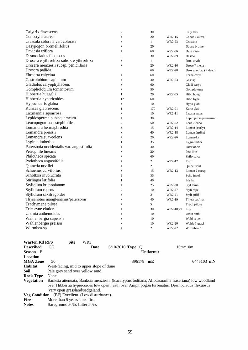
59
Calytrix flavescens 2 30 Caly flav Conostylis aurea + 20 WR2-15 Conos ? aurea Crassula colorata var. colorata + 1 WR2-23 Crassula Dasypogon bromeliifolius + 20 Dasyp brome Daviesia triflora + 60 WR2-06 Davi ? tris Desmocladus flexuosus 3 30 WR2-09 Desmo Drosera erythrorhiza subsp. erythrorhiza + 1 Dros eryth Drosera menziesii subsp. penicillaris + 20 WR2-16 Drose ? menz Drosera pallida 60 WR2-28 Dros mac/pal (+ dead) Ehrharta calycina + 60 Ehrha calyc Gastrolobium capitatum + 30 WR2-03 Gast sp Gladiolus caryophyllaceus + 60 Gladi caryo Gompholobium tomentosum + 50 Gomph tome Hibbertia huegelii 1 20 WR2-05 Hibb hueg Hibbertia hypericoides 12 60 Hibb hype Hypochaeris glabra + 10 Hypo glab Kunzea glabrescens 1 170 WR2-01 Kunz glab Laxmannia squarrosa + 10 WR2-11 Laxma squar Lepidosperma pubisquameum + 30 Lepid pubisquameumq Leucopogon conostephioides 2 50 WR2-02 Leuc ? cono Lomandra hermaphrodita + 15 WR2-14 Loman (curly) Lomandra preissii + 60 WR2-18 Loman (spike) Lomandra suaveolens + 20 WR2-26 Lomandra Lyginia imberbis 1 35 Lygin imber Patersonia occidentalis var. angustifolia + 30 Pater occid Petrophile linearis + 20 Petr line Philotheca spicata + 60 Philo spica Podotheca angustifolia + 2 WR2-17 P sp. Quinetia urvillei + 2 Quine urvil Schoenus curvifolius + 15 WR2-13 Loman ? caesp Scholtzia involucrata 2 35 Scho invol Stirlingia latifolia 1 40 Stir lati Stylidium brunonianum + 25 WR2-30 Styl 'brun' Stylidium repens 2 10 WR2-27 Styli repe Stylidium saxifragoides + 2 WR2-21 Styli 'pilif' Thysanotus manglesianus/patersonii + 40 WR2-19 Thysa pat/man Trachymene pilosa + 5 Trach pilosa Tricoryne elatior + 30 WR2-10,29 Lily Ursinia anthemoides + 10 Ursin anth Wahlenbergia capensis + 10 Wahl capen Wahlenbergia preissii + 10 WR2-20 Wahle ? graci Wurmbea sp. + 2 WR2-22 Wurmbea ? Warton Rd RPS Site WR3 Described CG Date 6/10/2010 Type Q 10mx10m Season E Uniformit Location MGA Zone 50 396178 mE 6445103 mN Habitat West-facing, mid to upper slope of dune Soil Pale grey sand over yellow sand. Rock Type None Vegetation Banksia attenuata, Banksia menziesii, (Eucalyptus todtiana, Allocasuarina fraseriana) low woodland over Hibbertia hypercoides low open heath over Amphipogon turbinatus, Desmocladus flexuosus very open grassland/sedgeland. Veg Condition (BF) Excellent. (Low disturbance). Fire More than 5 years since fire. Notes Bareground 30%. Litter 50%.

60
SPECIES LIST: Quad Name Cove C Heigh Specime Notes Allocasuarina humilis + 100 A. humilis Amphipogon turbinatus 3 25 WR3-1 Amphipogon Anigozanthos humilis + 20 Anigozanthos humlis Austrodanthonia occidentalis + 40 WR3-28 Poaceae sp (slender) Austrostipa flavescens + 25 WR3-26 ? Austrostipa Austrostipa variabilis + 60 WR3-27 Tall native grass Banksia attenuata 6 550 Banksia attenuata (1% dead) Banksia menziesii 5 400 B. menziezii (2% dead) Bossiaea eriocarpa + 20 WR3-21 Bossiaea eriocarpa Briza maxima + 20 Briza maxima Burchardia congesta + 30 Burchardia cong Calytrix flavescens 2 20 WR3-6 ?Calytrix flavescens Conostylis aculeata subsp. preissii + 20 WR3-18 Conostylis ? aurea Crassula colorata var. colorata + 2 WR3-25 ? Crassula Dampiera linearis + 20 Dampiera linearis Dasypogon bromeliifolius + 20 Dasypogon brom Daviesia triflora + 40 WR3-16 Daviesia Desmocladus flexuosus 1 25 WR3-3 Desmocladus sp Drosera menziesii subsp. penicillaris + 60 WR3-10 Drosera pink Drosera pallida/menziesii + 5 WR3-24 Drosera Ehrharta calycina + 50 Ehrharta calycina Eucalyptus todtiana 5 600 Eucalyptus todtiana Gladiolus caryophyllaceus + 80 Gladiolus caryo Gompholobium tomentosum 1 40 Gompholobium toment Hibbertia huegelii + 30 WR3-13 Hibbertia hueg Hibbertia hypericoides 40 60 Hibbertia hyp Laxmannia ramosa subsp. ramosa + 10 WR3-12 Laxmannia Laxmannia squarrosa + 20 WR3-14 Laxmannia on stilts Lepidosperma scabrum (Inland form) + 40 WR3-20 Lepidosperma tevete Lepidosperma sp. Coastal Dunes + 60 WR3-8 Lepidosperma ? pubisqu Leucopogon conostephioides + 50 WR3-19 Epacrid small fwrs Lomandra caespitosa + 25 WR3-5,30 Lomandra (narrow lf) Lomandra hermaphrodita + 30 WR3-11,23 Lomandra bluish Lyginia barbata + 50 (=WR1-24) Lyginia imberbis Patersonia occidentalis var. angustifolia + 30 Patersonia occident Petrophile linearis + 30 Petrophile linearis Philotheca spicata 1 50 Philotheca spicata Podotheca angustifolia + 3 WR3-22 Podotheca Schoenus curvifolius + 25 WR3-29 ? Schoenus Stirlingia latifolia 2 50 Stirlingia latifolia Stylidium brunonianum + 25 WR3-9 Stilidium linear fleshy Stylidium repens 4 10 WR3-2 Stylidium repens Stylidium saxifragoides + 15 WR3-15 Stylidium smll yellow Trachymene pilosa + 5 (=WR1-25) Trachymene pilosa Tricoryne elatior Tricoryne elatior Ursinia anthemoides + 15 Ursinia anthemoides

61
Warton Rd RPS Site WR4 Described BRM Date 6/10/2010 Type Q 10x10 Season E Uniformit Location MGA Zone 50 395973 mE 6444979 mN Habitat North facing, very gently sloping to flat seasonal dampland. Soil Grey sand. Rock Type None Vegetation Melaleuca preissiana, (Allocasuarina fraseriana) low open forest over Xanthorrhoea preissii, Astartea affinis open shrubland over Hypocalymma angustifolium scattered low shrubs over Dasypogon bromeliifolius open herbland to herbland and Chamaescilla corymbosa open annual herbland. Veg Condition (BF) Excellent. (Low disturbance; some weeds (<5%)) Fire More than 5 years since last fire. Notes Litter >90%. SPECIES LIST: Quad Name Cove C Heigh Specime Notes Acacia pulchella var. goadbyi + 100 WR4-34 Acac pulc (o/hang + seedling) Aira caryophyllea + 4 WR4-23 Aira Allocasuarina fraseriana 8 800 Allocasuarina Astartea affinis 4 190 WR4-2 Astartea Austrostipa flavescens + 20 WR4-30 Austrost Avena barbata + 25 WR4-21 Grass Baumea juncea + 50 WR4-6 Baumea juncea (not collected!) Boronia ramosa subsp. anethifolia + 20 WR4-27 Boronia Bossiaea eriocarpa + 30 Bossiaea eriocarpa Briza maxima + 30 Briza max Briza minor + 10 Briza minor Burchardia congesta + 30 Burch conge Caladenia flava subsp. flava + 15 Caladenia flava var. flava Calandrinia corrigioloides + 3 WR4-8,10 Calandrinia Centrolepis drummondiana + 2 WR4-24 Centrolepis Chamaescilla corymbosa 15 20 WR4-3 Chamaescilla corym Conostephium pendulum + 15 Conostep peno Conostylis juncea + 20 WR4-13,33 Conostylis Crassula colorata var. colorata + 1 WR4-22 Crassula Dasypogon bromeliifolius 25 40 Dasypogon brom Dianella revoluta var. divaricata + 35 Dianella rev Drosera pallida + 45 WR4-5 Drosera climber Eriochilus dilatatus subsp. multiflorus + 15 WR4-14 Orchid spade lf Fumaria capreolata + 10 Fumaria weed (white Gladiolus caryophyllaceus + 70 Gladiolus caryo Hibbertia hypericoides + 40 Hibbertia hypercoides Hibbertia subvaginata + 25 WR4-20 Hibbertia vag Hovea trisperma + 20 Hovea elliptica Hyalosperma cotula + 4 WR4-7 daisy wte Hypocalymma angustifolium + 50 Hypocalymma angust Hypochaeris glabra + 1 Hypochaeris glabra Isolepis marginata + 2 WR4-11 Isolepis ? mag Lagenophora huegelii + 12 Lagenophora huegelii Lepidosperma sp. + 45 WR4-15,29 Sedge Lepidosperma sp. K Boorabbin (K.L. Wilson + 45 WR4-16 Sedge Lomandra caespitosa + 20 WR4-19 Lomandra caespitosa Lomandra preissii + 40 WR4-4 Lomandra preissii Melaleuca preissiana 60 700 WR4-1 Melaleuca preissiana Oxalis pes-caprae + 30 Oxalis pes-caprae Phlebocarya ciliata + 30 WR4-17,32 Conost acul Podotheca gnaphalioides + 15 WR4-26 Podotheca ?grac /chrys Poranthera microphylla + 3 WR4-18 ? Poranthera micro Quinetia urvillei + 2 Quinetia urvillei

62
Siloxerus humifusus + 1 WR4-31 Siloxeros Sonchus oleraceus + 2 Sonchus oleraceus Thelymitra sp. + 20 WR4-25 Thelymitra orchid Thysanotus manglesianus/patersonii + 20 Thysanotus mang/pat Trachymene pilosa + 5 Trachymene pilosa Wahlenbergia preissii + 20 WR4-9,12,28 Wahlenb (native) Xanthorrhoea preissii 7 180 Xanth preissii Warton Rd RPS Site WR5 Described BRM Date 6/10/2010 Type Q 10mx10m Season E Uniformit Location MGA Zone 50 396012 mE 6444933 mN Habitat Flat dampland. Soil Grey sand. Rock Type None Vegetation Acacia pulchella var. goadbyi scattered shrubs over Hypocalymma angustifolium, Pericalymma ellipticum scattered low shrubs over Baumea juncea, Schoenus subfascicularis closed sedgeland. Veg Condition (BF) Excellent. (Low disturbance; some weeds, rabbits). Fire More than 5 years since fire. Notes Bareground 3%. Litter 30%. SPECIES LIST: Quad Name Cove C Heigh Specime Notes Acacia pulchella var. goadbyi 1 140 WR5-2 Acacia pulchella Aira caryophyllea + 12 WR5-4 grass Anagallis arvensis + 12 Anagallis arvensis (sterile) Astartea affinis + 10 WR5-7 Astartea (juv) Austrostipa flavescens + WR5-17 ?Austrostipa Baumea juncea Boronia ramosa subsp. anethifolia + 35 WR5-11,20 Boronia ?racemosa Briza maxima + 20 Briza max Carpobrotus edulis + 3 Carpobrotus (pigface) Chamaescilla corymbosa + 5 ??(=WR4-3) Chamaescilla (?grazed; finished flrg) Dasypogon bromeliifolius + 50 Dasypogon brom Ehrharta calycina + 45 Ehrhata calyc Euchilopsis linearis 2 40 WR5-6 pea orange flr Gladiolus caryophyllaceus + 70 Gladiolus car (pk flr) Hyalosperma cotula + 5 (=WR4-7) daisy Hypocalymma angustifolium + 80 Hypocalymma angust Hypochaeris glabra 3 3 Hypochaeris glabra (cats tongue) Pericalymma ellipticum + 70 WR5-1 Pericalymma/ Leptosperm Phlebocarya ciliata + WR5-18 ? Phlebocarya Phyllangium divergens + 4 WR5-14 Phyllangium Quinetia urvillei + 3 Quinetia urvillei Rhodanthe citrina + 5 WR5-12 ? Waitzia Schoenus subfascicularis 90 60 WR5-3 Schoenus Selaginella gracillima + 2 WR5-15 Herb Siloxerus humifusus + 2 WR5-16 Herb? Siloxerus Sonchus oleraceus + Sonchus oleracaceus Stylidium brunonianum + WR5-19 Stylidium Thysanotus manglesianus/patersonii + 40 Thysanotus mang/pat Trachymene pilosa + 3 Trachymene pilosa Ursinia anthemoides + 5 Ursinia art Vulpia myuros forma myuros + 40 WR5-10 Grass (?Vulpia) Wahlenbergia preissii + 4 WR5-13 Whalenbergia
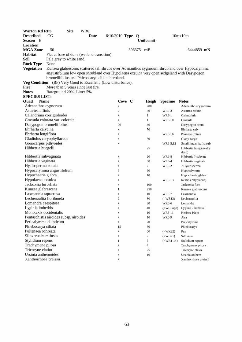
63
Warton Rd RPS Site WR6 Described CG Date 6/10/2010 Type Q 10mx10m Season E Uniformit Location MGA Zone 50 396375 mE 6444859 mN Habitat Flat at base of dune (wetland transition) Soil Pale grey to white sand. Rock Type None Vegetation Kunzea glabrescens scattered tall shrubs over Adenanthos cygnorum shrubland over Hypocalymma angustifolium low open shrubland over Hypolaena exsulca very open sedgeland with Dasypogon bromeliifolius and Phlebocarya ciliata herbland. Veg Condition (BF) Very Good to Excellent. (Low disturbance). Fire More than 5 years since last fire. Notes Bareground 20%. Litter 5%. SPECIES LIST: Quad Name Cove C Heigh Specime Notes Adenanthos cygnorum 7 200 Adenanthos cygnorum Astartea affinis 2 80 WR6-3 Astartea affinis Calandrinia corrigioloides + 1 WR6-1 Calandrinia Crassula colorata var. colorata + 1 WR6-10 Crassula Dasypogon bromeliifolius 20 40 Dasypogon brom Ehrharta calycina + 70 Ehrharta caly Ehrharta longiflora + WR6-16 Poaceae (mini) Gladiolus caryophyllaceus + 80 Glady caryo Gonocarpus pithyoides + WR6-5,12 Small linear leaf shrub Hibbertia huegelii 25 Hibbertia hueg (nealry dead) Hibbertia subvaginata + 20 WR6-8 Hibbertia ? subvag Hibbertia vaginata + 30 WR6-4 Hibbertia vaginata Hyalosperma cotula + 7 WR6-2 ? Hyalosperma Hypocalymma angustifolium 5 60 Hypocalymma Hypochaeris glabra + 10 Hypochaeris glabra Hypolaena exsulca + WR6-13 Restio (?Hyplaena) Jacksonia furcellata + 100 Jacksonia furc Kunzea glabrescens 1 250 Kunzea glabrescens Laxmannia squarrosa + 10 WR6-7 Laxmannia Lechenaultia floribunda 2 30 (=WB12) Lechenaultia Lomandra caespitosa + 30 WR6-6 Lomandra Lyginia imberbis 4 40 (=WC opp) Lyginia ? barbata Monotaxis occidentalis + 10 WR6-11 Herb to 10cm Pentaschistis airoides subsp. airoides + 10 WR6-9 Aira Pericalymma ellipticum + 70 Pericalymma Phlebocarya ciliata 15 30 Phlebocarya Pultenaea ochreata + 60 (=WK22) Pea Siloxerus humifusus + 2 (=WB21) Siloxerus Stylidium repens 1 5 (=WR1-14) Stylidium repens Trachymene pilosa + 4 Trachymene pilosa Tricoryne elatior + 25 Tricoryne elator Ursinia anthemoides + 10 Ursinia anthem Xanthorrhoea preissii + Xanthorrhoea preissii
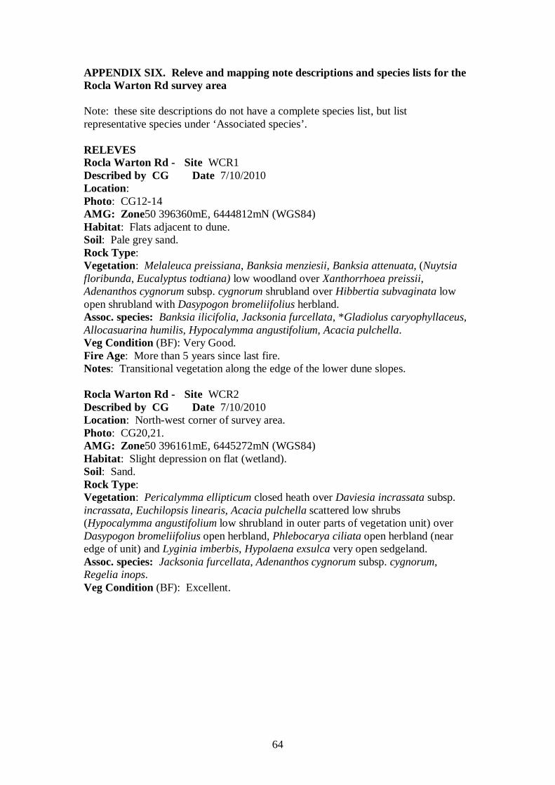
64
APPENDIX SIX. Releve and mapping note descriptions and species lists for the Rocla Warton Rd survey area Note: these site descriptions do not have a complete species list, but list representative species under ‘Associated species’. RELEVES Rocla Warton Rd - Site WCR1 Described by CG Date 7/10/2010 Location: Photo: CG12-14 AMG: Zone50 396360mE, 6444812mN (WGS84) Habitat: Flats adjacent to dune. Soil: Pale grey sand. Rock Type: Vegetation: Melaleuca preissiana, Banksia menziesii, Banksia attenuata, (Nuytsia floribunda, Eucalyptus todtiana) low woodland over Xanthorrhoea preissii, Adenanthos cygnorum subsp. cygnorum shrubland over Hibbertia subvaginata low open shrubland with Dasypogon bromeliifolius herbland. Assoc. species: Banksia ilicifolia, Jacksonia furcellata, *Gladiolus caryophyllaceus, Allocasuarina humilis, Hypocalymma angustifolium, Acacia pulchella. Veg Condition (BF): Very Good. Fire Age: More than 5 years since last fire. Notes: Transitional vegetation along the edge of the lower dune slopes. Rocla Warton Rd - Site WCR2 Described by CG Date 7/10/2010 Location: North-west corner of survey area. Photo: CG20,21. AMG: Zone50 396161mE, 6445272mN (WGS84) Habitat: Slight depression on flat (wetland). Soil: Sand. Rock Type: Vegetation: Pericalymma ellipticum closed heath over Daviesia incrassata subsp. incrassata, Euchilopsis linearis, Acacia pulchella scattered low shrubs (Hypocalymma angustifolium low shrubland in outer parts of vegetation unit) over Dasypogon bromeliifolius open herbland, Phlebocarya ciliata open herbland (near edge of unit) and Lyginia imberbis, Hypolaena exsulca very open sedgeland. Assoc. species: Jacksonia furcellata, Adenanthos cygnorum subsp. cygnorum, Regelia inops. Veg Condition (BF): Excellent.
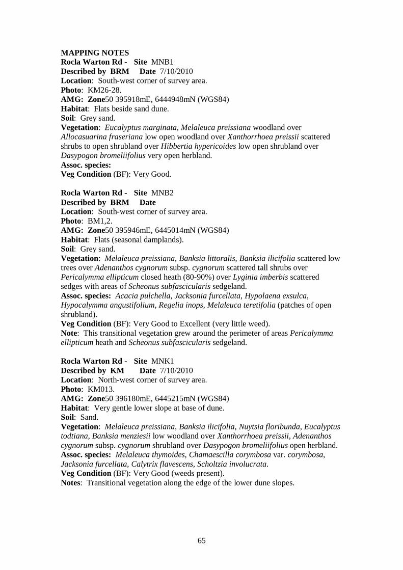
65
MAPPING NOTES Rocla Warton Rd - Site MNB1 Described by BRM Date 7/10/2010 Location: South-west corner of survey area. Photo: KM26-28. AMG: Zone50 395918mE, 6444948mN (WGS84) Habitat: Flats beside sand dune. Soil: Grey sand. Vegetation: Eucalyptus marginata, Melaleuca preissiana woodland over Allocasuarina fraseriana low open woodland over Xanthorrhoea preissii scattered shrubs to open shrubland over Hibbertia hypericoides low open shrubland over Dasypogon bromeliifolius very open herbland. Assoc. species: Veg Condition (BF): Very Good. Rocla Warton Rd - Site MNB2 Described by BRM Date Location: South-west corner of survey area. Photo: BM1,2. AMG: Zone50 395946mE, 6445014mN (WGS84) Habitat: Flats (seasonal damplands). Soil: Grey sand. Vegetation: Melaleuca preissiana, Banksia littoralis, Banksia ilicifolia scattered low trees over Adenanthos cygnorum subsp. cygnorum scattered tall shrubs over Pericalymma ellipticum closed heath (80-90%) over Lyginia imberbis scattered sedges with areas of Scheonus subfascicularis sedgeland. Assoc. species: Acacia pulchella, Jacksonia furcellata, Hypolaena exsulca, Hypocalymma angustifolium, Regelia inops, Melaleuca teretifolia (patches of open shrubland). Veg Condition (BF): Very Good to Excellent (very little weed). Note: This transitional vegetation grew around the perimeter of areas Pericalymma ellipticum heath and Scheonus subfascicularis sedgeland. Rocla Warton Rd - Site MNK1 Described by KM Date 7/10/2010 Location: North-west corner of survey area. Photo: KM013. AMG: Zone50 396180mE, 6445215mN (WGS84) Habitat: Very gentle lower slope at base of dune. Soil: Sand. Vegetation: Melaleuca preissiana, Banksia ilicifolia, Nuytsia floribunda, Eucalyptus todtiana, Banksia menziesii low woodland over Xanthorrhoea preissii, Adenanthos cygnorum subsp. cygnorum shrubland over Dasypogon bromeliifolius open herbland. Assoc. species: Melaleuca thymoides, Chamaescilla corymbosa var. corymbosa, Jacksonia furcellata, Calytrix flavescens, Scholtzia involucrata. Veg Condition (BF): Very Good (weeds present). Notes: Transitional vegetation along the edge of the lower dune slopes.
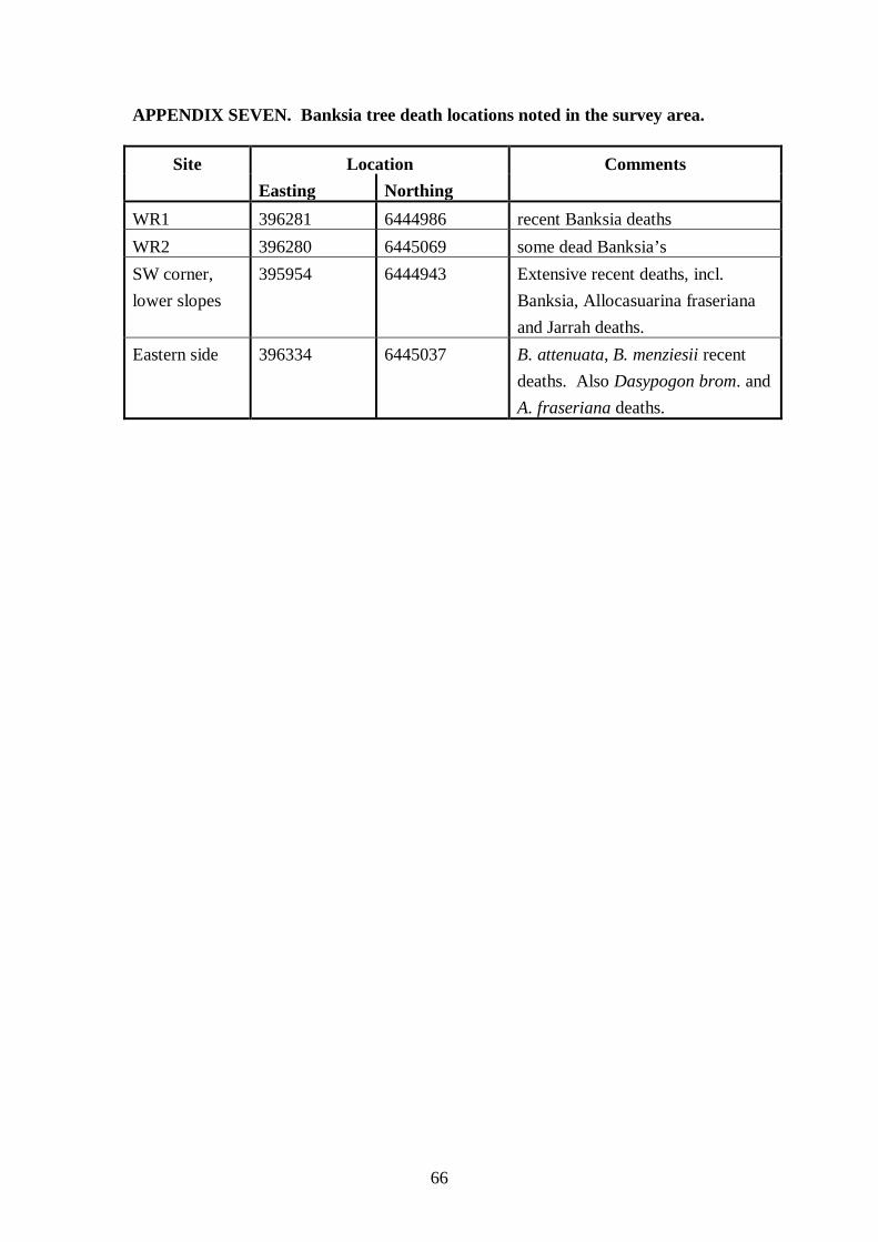
66
APPENDIX SEVEN. Banksia tree death locations noted in the survey area.
Site Location Comments Easting Northing WR1 396281 6444986 recent Banksia deaths WR2 396280 6445069 some dead Banksia’s SW corner, lower slopes
395954 6444943 Extensive recent deaths, incl. Banksia, Allocasuarina fraseriana and Jarrah deaths.
Eastern side 396334 6445037 B. attenuata, B. menziesii recent deaths. Also Dasypogon brom. and A. fraseriana deaths.

67
APPENDIX EIGHT Reproduction of a report ‘FCT Analysis Warton Rd Sites’
by Mr Ted Griffin
FCT Analysis Warton Sites for BR Morgan Ted Griffin May 2010
1
1.0 INTRODUCTION
1.1 Purpose of this report
The current report is intended to help clarify the assignment of Floristic Community
type (FCT) designation to vegetation community (site) data. FCTs were defined by
Gibson et al (1994) based on site data collected from vegetation on the Swan Coastal
Plain. In particular, the potential that a Threatened Ecological Community (English
and Blyth 1997) is represented by the data collected needs to be clarified.
1.2 Location of Warton Sites The sites were apparently from the Warton Rd area.
1.3 Brief background to floristic analysis of vegetation on the Swan Coastal Plain
Floristic analysis (ie., analysis of variation in vegetation based on the species present,
rather than description of structural variation and dominance) as a significant
component of the understanding of the variation present in the native vegetation of the
Swan Coastal Plain dates to Gibson et al (1994 – all references to the SCP survey in
the current report refer to this publication), the first publication to document the
floristics of the vegetation of a large part of the Swan Coastal Plain. While the SCP
survey is based on a very significant amount of work, it must be viewed as a “first
pass” survey, limited, in the context of the great variety of vegetation present in the
very large area surveyed, by the relatively limited number (509) of sites (quadrats) it
is based on. To a limited degree, this limitation has subsequently been addressed in
an “update” to the work of the SCP survey (which describes additional units).
However, there is no detailed publication of the results of this update available and
the additional data used are not readily available in an appropriate form (ie., one that
would enable ready comparison of new data to the overall data set).
The units described by the SCP survey are a series of “floristic community types”, a
“unit” whose rank is defined by the use within a study. The SCP survey surveyed a
very large survey area and defined a relatively small number of floristic community
types. Consequently, the floristic community types they have described are of a very
high order (see Trudgen 1999, volume 1, for further discussion of this point). This is
an extremely important point to fully grasp in interpreting the analysis presented by
the SCP survey and in understanding the meaning of analysis of other data sets when
they are compared to the floristic community types of the SCP survey.
The important effects of the limited size data set used by the SCP survey and of the
relatively small number of floristic community types defined by them, can be
summarised by the following points:
1. the definition of all but two of the Threatened Ecological Communities for
vegetation on the Swan Coastal Plain (English and Blyth 1997) has been based
on the floristic community types of the SCP survey. It therefore follows, that
with two exceptions, only vegetation units from one study that are different at
a very high order of floristics are treated as rare by Government. No account
is taken of other important differences, such as differences in structure and
dominance;
FCT Analysis Warton Sites for BR Morgan Ted Griffin May 2010
2
2. for the definition of floristic community types to be robust, a sufficient sized
database is needed to give adequate precision in their definition. About half of
the floristics community types (or sub types) of the SCP survey are based on
less than 10 sites. It is likely that with a larger data set there would be
significant alteration in the classification of those floristic community types
from the SCP survey based on small numbers of sites.
3. as noted above, many (if not most) of the floristic community types defined by
the SCP survey are very broad. They contain very significant variation in
floristics, structure and dominance. Some (or in more highly cleared parts of
the Swan Coastal Plain much) of this variation may be rare by any reasonable
definition, but it is currently “buried” within larger groups;
4. there is likely to be significant variation not sampled by the SCP survey. This
includes some variation at a high level of floristic difference (see Trudgen
1999, volume 1, for an example of this) and undoubtedly quite significant
(large!) amounts of variation at “medium” and “low” levels.
5. the document, and its use by Government, has focussed attention in the
environmental impact assessment process on the high level of units described,
deflecting attention from the layers of variation beneath these units that also
have significant conservation value.
From these points it is obvious that there is a need for a major “upgrade” to the
floristic analysis of the vegetation of the Swan Coastal Plain to provide a more
detailed floristic classification that considers not only more of the variation present,
but explicitly recognises more of the variation present in formally described units.
Obviously, such a reworking would have some effect on what vegetation is
considered rare on the Swan Coastal Plain. It needs to be stressed that it would be
very unlikely to find that any of the vegetation currently considered to be rare on the
basis of the SCP survey’s classification was not rare. On the other hand, it is likely
that such a review would very probably consider to be rare some vegetation which is
not currently considered rare.
1.4 Data provided
It is very important in comparing different sets of floristic data that they are
comparable in the application of names, in the intensity of the survey (ie., the effort of
searching resulting in similar proportion of the flora at sites being recorded) and in the
size of the site recorded. If the data from different data sets is not comparable in these
ways, it reduces the clarity of the results of the analyses carried out. If the
discrepancy in the comparability of the data sets is large, the results may become
meaningless.
A brief observation suggest that these Warton sites appears to have similar number of
species from groups such as Orchids.
FCT Analysis Warton Sites for BR Morgan Ted Griffin May 2010
3
2.0 METHODS
2.1 Data Preparation
The data from the Warton sites were provided into a standard MS Access based
database designed for this type of data. One virtue of the database is that the species
recorded at each site are stored against standard codes (numbers, those used by the
Western Australian Herbarium) for each species. This facilitates ready comparison of
data from different surveys stored in the same system.
After the data were incorporated into the database (containing the data from other
projects), a process of reconciliation of flora species names with those used in the
SCP survey was undertaken. This step was necessary at least because of changes in
nomenclature over the last ten years and the potential of survey specific variations in
the application of names. The reconciliation involved:
• reducing some infra-specific names to the relevant species name,
• combining some taxa where confusion is known to have occurred in field
observations and identifications, and
• omitting some names (mostly, where a species had only been identified to genus).
The reconciliation process was relatively straight forward as most of the names had
already been standardised. Most reconciliation was to conform with the methods that
the SCP survey used to manage confusing taxa plus some nomenclatural changes (see
Appendix).
2.2 Comparability of datasets
It was concluded that the datasets were probably compatible to obtain reliable
determinations.
2.3 Comparisons made
The data from the 6 sites plus the 509 sites from the SCP survey of the southern part
of the Swan Coastal Plain (south of Gingin) were combined. This enabled various
analyses to be performed.
The main purpose was intended to assign the individual sites to the Floristic
Community Types (FCTs) defined in the SCP survey.
These data are provided in BM_Warton.mdb.)
2.4 Analyses carried out
The approach was the use of numerical classification techniques (PATN) based on the
similarity of the floristic composition of the Warton sites to sites in the SCP survey
data set.

FCT Analysis Warton Sites for BR Morgan Ted Griffin May 2010
4
2.4.1 PATN
Several modules of the numerical classification package PATN (Belbin 1987) were
used for the analyses. The parameter values were the same as used by the SCP survey
used to ensure consistency of analysis with that study.
The PATN modules used were ASO (calculation of similarity matrix), FUSE
(classification based on the results of ASO), DEND (representation of classification)
and NNB (determination of sites most similar to each site – nearest neighbours). The
results of the analyses were imported into a database (BM_Eglington.mdb) so that site
characteristics and previous classifications (eg., Floristic Community Types derived
in earlier classifications) could be associated and various analyses based on these data
could be performed.
The assignment of floristic community types to the Warton sites was made by
summarising the results of two different methods:
• the classification, and
• the ten nearest neighbours.
Experience demonstrates that the results of these are likely to vary, but that from
nearest neighbours is likely to make more sense.
To the classification dendrogram of the combined dataset the FCT assigned by the
SCP survey was associated with the SCP survey sites. The apparent FCTs were
assigned to the Warton sites by interpreting the position of these sites in the
dendrogram (particularly by the way they joined to the SCP sites.
The 10 sites in the combined data set that were most similar to each of the Warton
sites were obtained from the nearest neighbour method (NNB). By associating those
nearest neighbours from the SCP survey, the most likely FCTs for each of the Warton
sites were determined.
An attempt was then made to reconcile these different assignments of a Floristic
Community Type.
3.0 LIMITATIONS
It has been found in earlier projects that the addition of new sites to the SCP survey
data set to produce a combined classification disrupts the original classification. The
more data added, the higher the level of the disruption. This problem can make it
difficult to assign Floristic Community Types to new sites using this method.
Secondly, it is common for new data to group to their cohorts. In some cases this has
proven to result from common deficiencies in the data, ie. whole groups of species
missing. This absence tends to draw them together. The more sites in the added
batch, the tighter they draw together.
The analyses are conducted without personal knowledge of the sites and no
photographs were provided.
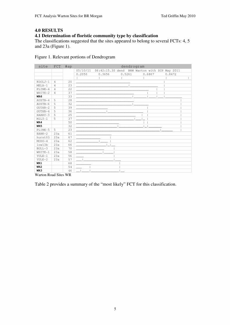
FCT Analysis Warton Sites for BR Morgan Ted Griffin May 2010
5
4.0 RESULTS
4.1 Determination of floristic community type by classification
The classifications suggested that the sites appeared to belong to several FCTs: 4, 5
and 23a (Figure 1).
Figure 1. Relevant portions of Dendrogram
site FCT #sp dendrogram 05/10/11 06:42:15.30 dend BRM Warton with SCP May 2011
0.2050 0.3656 0.5261 0.6867 0.8472
| | | | | |
KOOLJ-1 4 20 _____________________________ |
MELA-1 4 23 ____________________________|_______________ |
PLINE-4 4 22 _______________________________________ | |
WHITE-2 4 37 _______________________________ | | |
WR6 33 ______________________________|_______|____|___|_________
AUSTB-4 5 28 _______________________________ |
AUSTB-6 5 32 ______________________________|________ |
GUTHR-2 5 39 _________________ | |
GUTHR-4 5 36 ________________|___________________ | |
HARRY-3 5 25 ________________________________ | | |
MILT-1 5 37 _______________________________|___|_ | |
WR4 50 _______________________ | | |
WR5 32 ______________________|_____________|_|_______ |
PLINE-5 5 23 _____________________________________________|______ |
BANK-2 23a 61 ___________________
hurst03 23a 67 _____________ |
MODO-4 23a 62 ____________|____ |
low13b 23a 66 ________________|_|__
BULL-3 23a 70 _______________ |
WHITE-1 23a 58 ______________|_____|
YULE-1 23a 56 ____ |
YULE-2 23a 57 ___|________________|___
WR1 68 ________ |
WR2 54 ___ | |
WR3 46 __|____|_______________|__
Warton Road Sites WR
Table 2 provides a summary of the “most likely” FCT for this classification.

FCT Analysis Warton Sites for BR Morgan Ted Griffin May 2010
6
4.2 Determination of floristic community type using Nearest Neighbour method
The nearest neighbour analysis suggests that the sites also belong to a number of
communities but principally FCT 23a, 5, 28 and 22.
Table 1. Results of Nearest Neighbour analysis s s1 fct1 v1 s2 fct2 v2 s3 fct3 v3 s4 fct4 v4 s5 fct5 v5
WR1 WR2 0.2333 WR3 0.3514 hurst03 23a 0.3534 WARB-3 23a 0.4101 YULE-2 23a 0.4146
WR2 WR3 0.2323 WR1 0.2333 hurst03 23a 0.3719 WIRR-1 23a 0.4154 YULE-2 23a 0.4234
WR3 WR2 0.2323 WR1 0.3514 hurst03 23a 0.375 WAND-1 23a 0.4314 YULE-2 23a 0.4314
WR4 WR5 0.4937 hurst03 23a 0.5652 NEER-5 28 0.5682 HARRY-1 28 0.5745 hurst02 23a 0.5789
WR5 WR4 0.4937 GUTHR-2 5 0.5714 HARRY-3 5 0.6071 MILT-1 5 0.6176 WR6 0.625
WR6 WHITE-2 4 0.6 WR5 0.625 MELA-5 22 0.6338 BANK-1 22 0.6364 hurst03 23a 0.64
Table 1 (cont) s s6 fct6 v6 s7 fct7 v7 s8 fct8 v8 s9 fct9 v9 s10 fct10 v10
WR1 WIRR-2 23a 0.4307 YULE-1 23a 0.4426 NINE-2 21a 0.45 WIRR-1 23a 0.4507 MODO-4 23a 0.4531
WR2 WHITE-1 23a 0.4464 YULE-1 23a 0.4545 WARB-3 23a 0.4646 MODO-4 23a 0.4655 BULL-3 23a 0.4677
WR3 WHITE-1 23a 0.4369 BULL-3 23a 0.4609 DEJONG-c 21c 0.4651 WIRR-1 23a 0.4711 MODO-4 23a 0.4766
WR4 WR1 0.5789 hurst01 23a 0.5789 BULLER-3 21c 0.5842 CORON-1 21a 0.5842 GUTHR-3 21a 0.6
WR5 GUTHR-1 4 0.6429 WR1 0.6495 AUSTB-6 5 0.6508 low08 5 0.6571 MODO-6 4 0.661
WR6 MODO-2 21c 0.6471 WR4 0.6543 GUTHR-2 5 0.6667 MODO-1 4 0.6716 MODO-6 4 0.6721
s – the site being compared
s1 to s10 – the 1st to 10
th most similar sites
f1 to f10 – the FCT of the similar sites (only for SCP sites)
v1 to v10 – the dissimilarity value between the site and the similar sites (values above 0.6 tend to
indicate low similarity)
4.3 Combining the results
It is common for the classification to indicate a simple result and the nearest
neighbour analysis to be less conclusive. This is more a product of the classification
process often suggesting an over simplified view than of inconsistency of the
analyses.
There appeared to be reasonable accord in that both methods suggested the same FCT
for 4 of the 6 sites.
Table 2 Summary of results
Site Dendrogram FCT NNB FCT Summary FCT
WR1 23a 23a 23a
WR2 23a 23a 23a
WR3 23a 23a 23a
WR4 5 23a/28 23a/5
WR5 5 5 5
WR6 4 4/22/23a 4?
FCT Analysis Warton Sites for BR Morgan Ted Griffin May 2010
7
4.0 REFERENCES
Belbin, L. (1987) PATN Reference Manual (313p), Users Guide (79p), Command
Manual (47p), and Example Manual (108p). CSIRO Division of Wildlife and
Ecology, Lynham, ACT.
English, V., and Blyth, J. (1997) Identifying and conserving threatened ecological
communities (TECs) in the South West Botanical Province. ANCA National
Reserves System Cooperative Program: Project Number N702, Australian
National Conservation Agency, Canberra
Gibson, N.G., Keighery, B.J., Keighery, G.J., Burbidge, A.H. and Lyons, M (1994). A
Floristic Survey of the Southern Swan Coastal Plain. Unpublished report by the
Department of Conservation and Land Management and the Conservation
Council of Western Australia to the Australian Heritage Commission.
Trudgen, M.E. (1999). A flora and vegetation survey of Lots 46 and 47 Maralla Road
and Lexia Avenue, Ellenbrook. Volumes 1-4. Unpublished report prepared for
the Crown Solicitors Office, Government of Western Australia. December
1999.

FCT Analysis Warton Sites for BR Morgan Ted Griffin May 2010
8
5.0 APPENDIX
Appendix 1 Species combinations made to assist in reconciling taxonomic changes
and identification difficulties between this survey and SCP data.
FCODE Species_LUP.name Species_LUP_1.name
031 Aira caryophyllea Aira caryophyllea/cupaniana group
031 Austrostipa variabilis Austrostipa semibarbata/campylachne
031 Avena barbata Avena barbata/fatua
031 Pentaschistis airoides subsp. airoides Pentaschistis airoides/pallida
031 Vulpia myuros forma myuros Vulpia myuros
032 Lepidosperma pubisquameum Lepidosperma angustatum/squamatum
032 Lepidosperma scabrum (Inland form) Lepidosperma scabrum
032 Lepidosperma sp. Lepidosperma angustatum/squamatum
032 Lepidosperma sp. Coastal Dunes Lepidosperma angustatum/squamatum
032 Lepidosperma sp. K Boorabbin (K.L. Wilson 2579) Lepidosperma angustatum/squamatum
032 Lepidosperma squamatum Lepidosperma angustatum/squamatum
032 Schoenus subfascicularis Baumea juncea
039 Lyginia imberbis Lyginia barbata
054E Dianella revoluta var. divaricata Dianella revoluta
054F Chamaescilla corymbosa Chamaescilla spiralis/corymbosa
054F Laxmannia ramosa subsp. ramosa Laxmannia ramosa
054F Thysanotus manglesianus/patersonii Thysanotus patersonii/manglesianus
054J Burchardia congesta Burchardia umbellata/congesta
055 Conostylis aculeata subsp. aculeata Conostylis aculeata
055 Conostylis aculeata subsp. preissii Conostylis aculeata
060 Patersonia occidentalis var. angustifolia Patersonia occidentalis
066 Caladenia flava subsp. flava Caladenia flava
066 Eriochilus dilatatus subsp. multiflorus Eriochilus dilatatus
066 Pterostylis sp.
066 Thelymitra sp.
143 Drosera pallida/menziesii
149 Crassula colorata var. colorata Crassula colorata
163 Acacia applanata Acacia willdenowiana
163 Acacia pulchella var. goadbyi Acacia pulchella
165 Gastrolobium capitatum Nemcia capitata
165 Hovea trisperma Hovea trisperma var. trisperma
175 Boronia ramosa subsp. anethifolia Boronia ramosa
273 Astartea affinis Astartea aff. fascicularis
273 Hypocalymma sp.
273 Kunzea glabrescens Kunzea ericifolia
302 Phyllangium divergens Phyllangium paradoxum
343 Stylidium saxifragoides Stylidium piliferum
345 Lagenophora huegelii Lagenifera huegelii