level crossing removal project - … · the level crossing removal program to remove 50 dangerous...
TRANSCRIPT

Page 1 of 43
Document Information
Document Number NEP-000-NEA-PLN-XEV-0002
Revision Number 0
Date 31 March 2017
LEVEL CROSSING REMOVAL PROJECT
North Eastern Program Alliance Environmental Management Strategy
Page 3 of 43
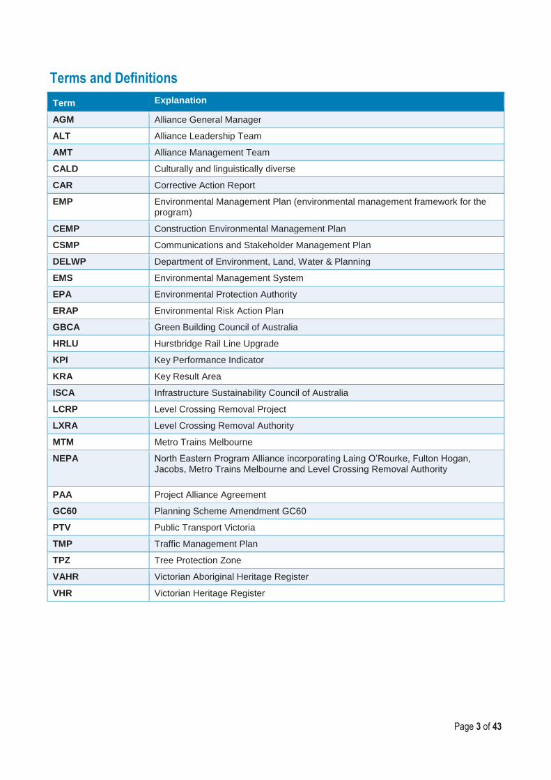
Terms and Definitions
Term Explanation
AGM Alliance General Manager
ALT Alliance Leadership Team
AMT Alliance Management Team
CALD Culturally and linguistically diverse
CAR Corrective Action Report
EMP Environmental Management Plan (environmental management framework for the program)
CEMP Construction Environmental Management Plan
CSMP Communications and Stakeholder Management Plan
DELWP Department of Environment, Land, Water & Planning
EMS Environmental Management System
EPA Environmental Protection Authority
ERAP Environmental Risk Action Plan
GBCA Green Building Council of Australia
HRLU Hurstbridge Rail Line Upgrade
KPI Key Performance Indicator
KRA Key Result Area
ISCA Infrastructure Sustainability Council of Australia
LCRP Level Crossing Removal Project
LXRA Level Crossing Removal Authority
MTM Metro Trains Melbourne
NEPA North Eastern Program Alliance incorporating Laing O’Rourke, Fulton Hogan, Jacobs, Metro Trains Melbourne and Level Crossing Removal Authority
PAA Project Alliance Agreement
GC60 Planning Scheme Amendment GC60
PTV Public Transport Victoria
TMP Traffic Management Plan
TPZ Tree Protection Zone
VAHR Victorian Aboriginal Heritage Register
VHR Victorian Heritage Register

Page 4 of 43
TABLE OF CONTENTS 1 Introduction .......................................................................................................................... 6
2 PROJECT DESCRIPTION ..................................................................................................... 7
2.1 Project Delivery Structure .................................................................................................... 7
2.2 Project Background ............................................................................................................. 7
2.3 Project Scope ...................................................................................................................... 7
2.4 Existing Environmental Conditions of Core NEPA Project Components ............................ 10
3 PROJECT APPROVALS ..................................................................................................... 14
4 CONSTRUCTION METHODOLOGIES ................................................................................ 15
4.1 Overall construction strategy ............................................................................................. 15
4.1.1 Heidelberg Track Duplication ............................................................................................ 15
4.1.2 Rosanna ........................................................................................................................... 17
4.1.3 Grange Road .................................................................................................................... 17
4.2 Approach to Occupations .................................................................................................. 18
5 APPROACH TO SITE ENVIRONMENTAL MEASURES ..................................................... 20
5.1 Environmental Management Framework ........................................................................... 20
5.2 Environmental and amenity effects approach .................................................................... 23
5.2.1 Vegetation ......................................................................................................................... 23
5.2.2 Fauna ................................................................................................................................ 24
5.2.3 Erosion, sedimentation and water quality .......................................................................... 24
5.2.4 Groundwater quality .......................................................................................................... 24
5.2.5 Contaminated Land ........................................................................................................... 25
5.2.6 Weed dispersal ................................................................................................................. 26
5.2.7 Local amenity .................................................................................................................... 26
5.2.8 Hazardous substances ...................................................................................................... 27
5.2.9 Waste ................................................................................................................................ 27
5.2.10 Mud and dirt on roads ....................................................................................................... 27
5.2.11 Noise ................................................................................................................................. 28
5.2.12 Vibration ............................................................................................................................ 29
5.2.13 Working Days and Working Hours .................................................................................... 29
5.2.14 Air Quality ......................................................................................................................... 30
5.2.15 Light spill ........................................................................................................................... 31
5.2.16 Traffic, transport and car parking management ................................................................. 31
5.2.17 Heritage ............................................................................................................................ 31
5.2.18 Sustainability ..................................................................................................................... 32

Page 5 of 43
5.2.19 Service Works ................................................................................................................... 32
6 COMMUNITY AND STAKEHOLDER ENGAGEMENT ........................................................ 34
6.1 Construction notification timeframes.................................................................................. 34
6.2 Managing community and stakeholder contacts ................................................................ 35
6.2.1 Response timeframes ....................................................................................................... 36
6.2.2 Complaint Management .................................................................................................... 37
6.2.3 Councils ............................................................................................................................ 38
7 PERFORMANCE MONITORING AND REPORTING ........................................................... 42
7.1 Performance Monitoring .................................................................................................... 42
7.2 Reporting .......................................................................................................................... 42
8 DOCUMENT CONTROL AND UPDATE .............................................................................. 43
8.1 Issue, Revision and Re-issue ............................................................................................ 43
Page 6 of 43
1 INTRODUCTION
Over the next eight years, the Victorian State Government will deliver a coordinated program to
remove 50 level crossings in Melbourne, improving safety, reducing congestion and enabling more
frequent train services. Delivery of these projects is being overseen by the Level Crossing Removal
Authority (LXRA).
The level crossing removal works will be undertaken at multiple sites in separate project packages
for the delivery of the entire Level Crossings Removal Project (LCRP). The Hurstbridge Rail Line
Upgrade (HRLU) Project (the Project) is incorporated under the LCRP framework, incorporating the
delivery of major rail upgrades along the Hurstbridge Rail Line. The Project will be delivered in
stages with critical works brought forward into an Initial Works Package (IWP) and long lead works
undertaken in an “Additional Works Package” (AWP). Collectively, the IWP and AWP form part of
the Level Crossing Removal Program to remove 50 dangerous level crossings across metropolitan
Melbourne by 2024.
This Environmental Management Strategy (the EMS) outlines the overarching approach for delivery
of the IWP, which will be adopted to identify and manage environmental risk and impacts of projects
associated with the Project.
The Project requires a number of approvals, with the principal approval being the Planning Scheme
Amendment (GC60), which has been approved by the Minister for Planning under the Planning and
Environment Act 1987. GC60 inserts a site specific planning control, an incorporated document, into
the relevant planning schemes to allow for land identified within the Incorporated Document to be
used and developed for the purposes of the Project, without the need to obtain additional planning
approvals subject to the conditions of the Incorporated Document being satisfied.
This Strategy has been prepared to satisfy Condition 4.2.1 of the Incorporated Document which
requires that the EMS must include:
A summary of key construction methodologies (Section 4)
An overarching framework for site or works specific measures to reduce and manage environmental and amenity effects during construction (Section 5)
A summary of the consultation that informed the preparation of the EMS and a summary of the proposed ongoing engagement activities with Councils, the community and other stakeholders during construction of the Project, including inquiries and complaints management (Section 6)
A summary of performance monitoring and reporting processes, including auditing, to ensure environmental and amenity effects are reduced and managed during construction of the Project (Section 7)

Page 7 of 43
2 PROJECT DESCRIPTION
2.1 Project Delivery Structure
LXRA has established a program approach for delivery of the LCRP, engaging contractors to deliver
the removal of multiple level crossings in a co-ordinated program of works. The Project is
incorporated under the LCRP framework that includes the delivery of a number of major rail
upgrades along the Hurstbridge Rail Line.
The North Eastern Program Alliance comprising of the Level Crossing Removal Authority (LXRA),
Metro Trains Melbourne (MTM), Laing O’Rourke Construction Pty Ltd (LORAC), Fulton Hogan
Construction Pty Ltd (FH) and Jacobs Group Australia Pty Ltd (Jacobs) has been appointed by the
Victorian Government to deliver the Project.
2.2 Project Background
The purpose of the project is to improve the efficiency of the road and rail transport network in North
East Melbourne by removing two level crossings and duplicating a section of the Hurstbridge rail
line.
Travel demand in the Whittlesea corridor is growing strongly with the annual patronage growth on
the South Morang Line forecast to continue growing at 6.4% for those travelling in the AM peak
towards the CBD. Modelling predicts the South Morang/Mernda Line will be overwhelmed by
passenger growth within the next five years, leaving more passengers unable to board peak hour
trains in the AM peak period.
Infrastructure constraints related to single track sections of the Hurstbridge Line limit the ability to
operate more peak period services across the Clifton Hill Group without introducing timetabling
constraints.
Lower Plenty Road and Grange Road are key arterials in the North Eastern corridor. Lower Plenty Road provides east-west connectivity between Rosanna and Heidelberg Heights. Grange Road runs north-south over the level crossing and connects to the Eastern Freeway to the south via the Chandler Highway.
The level crossings at Lower Plenty Road and Grange Road cause delays, largely due to irregular interruptions to the flow of traffic caused by the boom gate closures. This affects the overall travel time and reliability for road users, with boom gates down for at least 40 mins during the a.m. peak (7 am to 9 am).
2.3 Project Scope
A summary of the core works incorporated in the Project includes:
Grade Separation of Grange Road Alphington, known as Grade Separation #23 in the Government’s program of works. NEPA has elected to construct a rail under road configuration, requiring significant excavation of the existing rail corridor, and construction of an at-grade bridge on Grange Road.
Grade Separation of Lower Plenty Road Rosanna (Grade Separation #31 in the Government’s program of works). NEPA has elected to design and construct a rail over road configuration, requiring the construction of an elevated structure, over Lower Plenty Road.
Duplication of a single track section of rail line between Heidelberg and Rosanna Rail Stations. The additional track is to be constructed on the eastern side of the existing track, which includes the construction of a new single span bridge across Burgundy Street, and the

Page 8 of 43
construction of a second underpass (tunnel) portal adjacent to the existing underpass that passes under the intersection of Darebin Street and Hawdon Street.
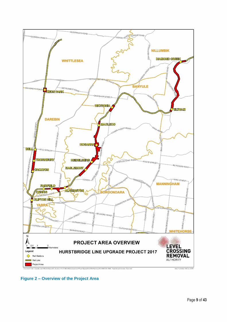
Figure 1 shows location of core works incorporated in the Project.
Figure 1 – Location of core NEPA project components
Other works
The project also includes power upgrades, new sections of Combined Services Route
communications and cabling infrastructure, earthworks, roadworks, potential service relocations, car
parking and bus interchange facilities at Keon Park, Watsonia and Clifton Hill rail stations.
The power upgrades involve new or upgraded electrical substations near Fairfield, Eaglemont,
MacLeod and Diamond Creek rail stations on the Hurstbridge rail line, and Bell rail station on the
South Morang rail line
The project also creates opportunities to improve pedestrian and cyclist connectivity and for new
public spaces, depending on the options selected for the removal of the level crossings.
Associated project elements include installation of new signalling and electrical and rail
communications infrastructure where new track is constructed.
Figure 2 shows an overview of the Project Area.
Grange Road, Alphington – Level Crossing Removal
Lower Plenty Road, Rosanna – Level Crossing Removal & New Station
Heidelberg Track Duplication
Page 9 of 43
Figure 2 – Overview of the Project Area

Page 10 of 43
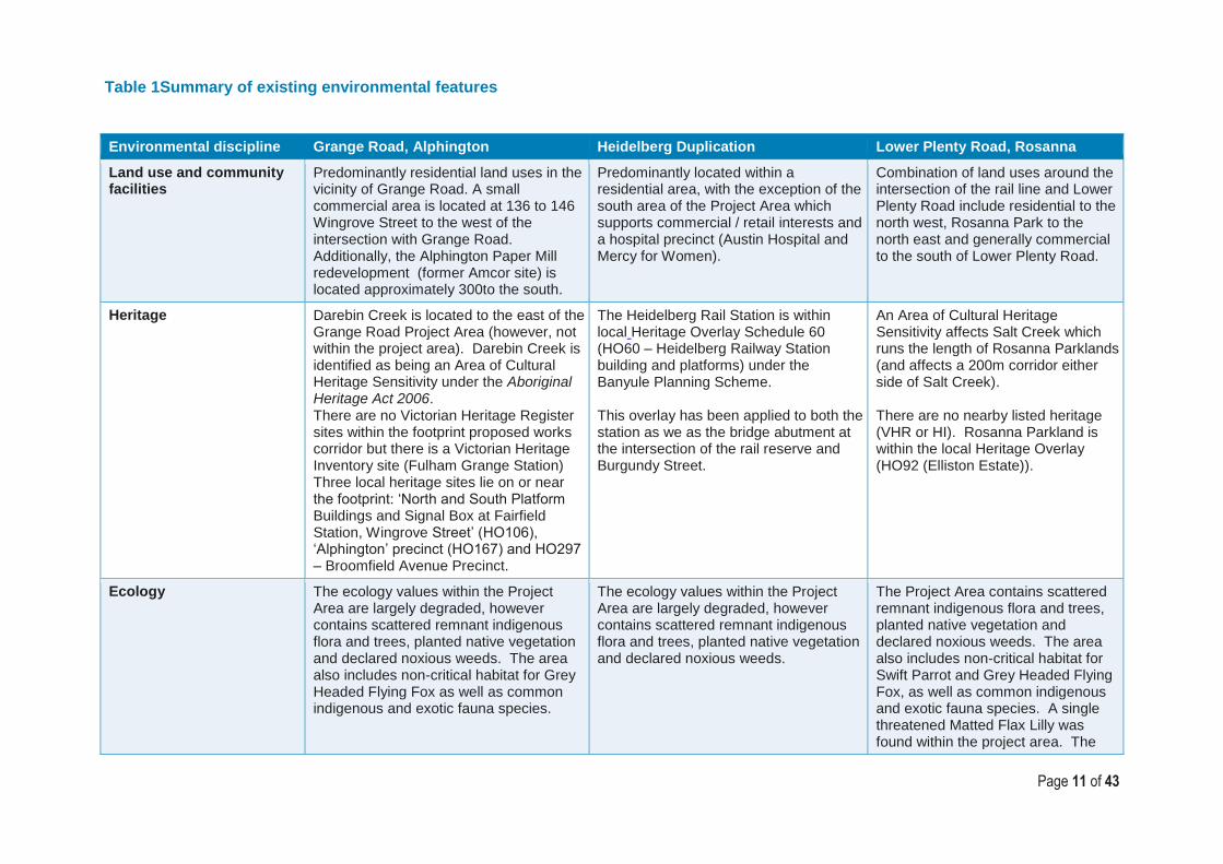
2.4 Existing Environmental Conditions of Core NEPA Project Components
The Hurstbridge Rail Line corridor between Alphington and Rosanna is a highly urbanised
environment, predominantly passing through areas that include residential and commercial (retail)
uses and public open spaces (including parklands).
A summary of the existing environmental conditions for each of the Projects core works is presented
in Table 1 below.
Page 11 of 43
Table 1Summary of existing environmental features
Environmental discipline Grange Road, Alphington Heidelberg Duplication Lower Plenty Road, Rosanna
Land use and community facilities
Predominantly residential land uses in the vicinity of Grange Road. A small commercial area is located at 136 to 146 Wingrove Street to the west of the intersection with Grange Road. Additionally, the Alphington Paper Mill redevelopment (former Amcor site) is located approximately 300to the south.
Predominantly located within a residential area, with the exception of the south area of the Project Area which supports commercial / retail interests and a hospital precinct (Austin Hospital and Mercy for Women).
Combination of land uses around the intersection of the rail line and Lower Plenty Road include residential to the north west, Rosanna Park to the north east and generally commercial to the south of Lower Plenty Road.
Heritage Darebin Creek is located to the east of the Grange Road Project Area (however, not within the project area). Darebin Creek is identified as being an Area of Cultural Heritage Sensitivity under the Aboriginal Heritage Act 2006. There are no Victorian Heritage Register sites within the footprint proposed works corridor but there is a Victorian Heritage Inventory site (Fulham Grange Station) Three local heritage sites lie on or near the footprint: ‘North and South Platform Buildings and Signal Box at Fairfield Station, Wingrove Street’ (HO106), ‘Alphington’ precinct (HO167) and HO297 – Broomfield Avenue Precinct.
The Heidelberg Rail Station is within local Heritage Overlay Schedule 60 (HO60 – Heidelberg Railway Station building and platforms) under the Banyule Planning Scheme. This overlay has been applied to both the station as we as the bridge abutment at the intersection of the rail reserve and Burgundy Street.
An Area of Cultural Heritage Sensitivity affects Salt Creek which runs the length of Rosanna Parklands (and affects a 200m corridor either side of Salt Creek). There are no nearby listed heritage (VHR or HI). Rosanna Parkland is within the local Heritage Overlay (HO92 (Elliston Estate)).
Ecology The ecology values within the Project Area are largely degraded, however contains scattered remnant indigenous flora and trees, planted native vegetation and declared noxious weeds. The area also includes non-critical habitat for Grey Headed Flying Fox as well as common indigenous and exotic fauna species.
The ecology values within the Project Area are largely degraded, however contains scattered remnant indigenous flora and trees, planted native vegetation and declared noxious weeds.
The Project Area contains scattered remnant indigenous flora and trees, planted native vegetation and declared noxious weeds. The area also includes non-critical habitat for Swift Parrot and Grey Headed Flying Fox, as well as common indigenous and exotic fauna species. A single threatened Matted Flax Lilly was found within the project area. The

Page 12 of 43
Environmental discipline Grange Road, Alphington Heidelberg Duplication Lower Plenty Road, Rosanna
removal of this single plant is not considered to be a significant impact under State or Commonwealth legislation.
Surface water Yarra River is located approximately 600m to the south of the project area, whilst Darebin Creek is located approximately 600m to the east of the project area.
Salt Creek runs generally parallel to the rail corridor, and is located approximately 150m east of the Project Area (at its closest point).
Salt Creek runs generally parallel to the rail corridor, and is located approximately 60m east of the Project Area (at its closest point).
Geology and soils Fill level varies from 0.2 – 0.7m depth. Shallow rock that may be very high strength (Newer Volcanic Basalt) is anticipated at variable shallow depth, potential for hard/slow excavation Rock mass quality likely to be variable, soils and weathered rock materials may be encountered below fresh rock.
Fill level varies from 0.2 – 0.5m depth. The upper 2 to 8 m of natural material consisted of predominantly clay type soils underlain by weathered siltstone interbedded with very thin to medium sandstone beds.
Fill level extends to 0.5m depth. Unknown thickness of compressible soils (Quaternary Alluvium, probably <5m thick) overlying weathered rock that may have deep weathering profile (Melbourne Formation). Alluvium likely to be primarily east of current rail corridor, thickest near Salt Creek channel.
Topography and drainage Region is generally flat with a surface elevation of approximately 34mAHD.
The southern end of the Project Area is undulating (surface elevation ranging from 40mAHD – 54mAHD), in which the existing rail corridor transitions from being on embankments, to in an excavation. The northern end of the area is generally flat (at a surface elevation of about 40mAHD).
Region is generally flat, with a slight rise in a northerly direction. Surface elevation of approximately 40mAHD.
Contamination Land has historically been used as a rail corridor. Some preliminary soil contamination investigations have been undertaken showing some isolated areas of low level contaminated soil (Cat C).
Land has historically been used as a rail corridor. Some preliminary soil contamination investigations have been undertaken demonstrating clean fill. However, further samples are required to be collected prior to construction.
Some preliminary soil contamination investigations were undertaken, demonstrating predominant clean fill, with one sample showing low level contamination (Cat C).
Groundwater Depth to groundwater ranges from 5m to 10m. Groundwater may be encountered in deep excavations.
Depth to groundwater has been monitored at a depth of 8.46m. It is not expected that groundwater will be
Depth to groundwater ranges from 0m to 5m. The piles for the viaduct structure and bridge structure are

Page 13 of 43
Environmental discipline Grange Road, Alphington Heidelberg Duplication Lower Plenty Road, Rosanna
intercepted. expected to extend below the groundwater level.
Arboriculture Slightly less than 100 trees have been identified within Grange Road project area. The retention value of the trees is diverse, ranging from low retention value to High Retention value, with trees within the rail corridor generally being of lower retention value than those in the Fairfield Railway spur.
Approximately 250 trees (combination of native and exotic species) are located within the proposed duplication area Heidelberg Rail Line Duplication area. The vast majority of those trees are located within the vicinity of the Heidelberg Rail Station extending to the north of Burgundy Street until the existing rail underpass. The majority of the trees around Heidelberg Rail Station are of a higher retention value, and are likely to remain unaffected by this project. The trees within Burgundy Street will be required to be removed to allow for the construction of the rail duplication.
Approximately 400 trees are located within the Lower Plenty Road Grade Separation portion of the proposed project area, including large numbers around De Winton Reserve and the Rosanna Primary School. Rosanna Parklands is located immediately to the east of the rail corridor, which supports a number of high retention value trees. The rail corridor extending from Lower Plenty Road to Rosanna Primary supports approximately 100 trees, although these are predominantly lower retention value.

Page 14 of 43
3 PROJECT APPROVALS
There are a number of planning, major project and environmental approvals applicable to the
Project. The primary planning approval for the Project is under the Planning and Environment Act
1987, through Planning Scheme Amendment GC60, which has been approved by the Minister for
Planning.
Other relevant legislation to the Project is detailed in Table 2 below.
Table 2Summary of project approvals
Legislation Responsible Authority Approval Purpose
Planning and Environment Act 1987
Department of Environment, Land, Water and Planning (DELWP) Minister for Planning.
PSA GC60 (which implements Hurstbridge Rail Line Upgrade 2017 Incorporated Document).
Gazettal of GC60 has facilitated the development of the Project subject to conditions contained in the approved Incorporated Document.
Major Transport Projects Facilitation Act 2009 (MTPF Act)
Premier of Victoria Minister for Planning Minister for Public Transport.
Project declaration and designation of an MTPF Act project boundary.
Declared for the purpose of enabling the Project Area for the delivery of the project works. Streamlines a number of land, road and works approvals under one act.
Aboriginal Heritage Act 2006
Wurundjeri Land Compensation and Cultural Heritage Council
Cultural Heritage Management Plan (CHMP).
Required where high intensity activities are undertaken in an area of cultural heritage sensitivity.
Heritage Act 1995 Heritage Victoria Heritage Permit Consent to Disturb
In the event that a works will impact on a registered place.
Flora and Fauna Guarantee Act 1988
DELWP Flora and Fauna Guarantee Permit
Permit to remove protected flora.
Water Act 1989 Melbourne Water Section 67 permit For works required to be conducted on water ways.
Wildlife Act 1975 DELWP Management authorisation for the salvage and handling of fauna.
In the event that works will require the removal or destruction of wildlife.

LEVEL CROSSING REMOVAL PROJECT
NEPA Environmental Management Strategy
Page 15 of 43
4 CONSTRUCTION METHODOLOGIES
4.1 Overall construction strategy NEPA has developed a construction management strategy to outline the approach to construction
including the methodology and strategy that will be implemented for the safe, effective and
successful delivery and execution of works for the Project to:
Develop and select options and innovations;
Overcome constraints; and
Optimise the balance between construction efficiency and minimising disruption to the railway and road network.
Key construction methodologies for each of Grange Road, Heidelberg duplication and Rosanna
(Lower Plenty Road) components of the Project are detailed below. The benefit of this integrated
approach is to have a clear understanding of the works that integrates the design with the
construction methodology.
NEPA will take a co-ordinated approach across the Project to optimise value for money to the State
of Victoria and minimise overall disruption to the transport network through the coordination of rail
occupations.
NEPA’s construction strategy is based on the following principles and objectives:
Adopting methodologies which provide best value for money;
Minimising works undertaken in a live rail environment;
Minimising road closures;
Maximising safety outcomes through innovative construction techniques and initiatives;
Developing and maintaining a flexible construction approach to capitalise on opportunities; and
Minimising impact on the rail commuters, local community and businesses.
4.1.1 Heidelberg Track Duplication In order to duplicate the existing single track from Heidelberg Rail Station to St James Road,
Heidelberg (south of Rosanna Rail Station), the existing alignment is required to be widened to the
east to facilitate the construction of the new rail track. The existing alignment from Heidelberg Rail
Station to Rosanna Rail Station comprises of elevated fill embankments on either side of Burgundy
Street and then transitions into deep cuts under Darebin Street past Brown Street and then at grade
to the turn out before Rosanna Rail Station.
The works proposed include:
retaining walls either side of Burgundy Street at Heidelberg;
a new steel girder bridge adjacent to the existing;
a new underpass under Darebin Street and to the east of the existing rail underpass;
embankment widening from Darebin Street to Brown Street;
localised retaining walls where current width is not sufficient and new rail systems; and
a track through the abovementioned extents tying into the current turnout locations.

LEVEL CROSSING REMOVAL PROJECT
NEPA Environmental Management Strategy
Page 16 of 43
A description of the key elements of the Heidelberg duplication component of the Project and
constraints is described below.
4.1.1.1 Burgundy Street Bridge
The construction of a new span for the existing single track Burgundy Street Bridge is required to
enable duplication of the track between Heidelberg and Rosanna Rail Station
The new 40m span will comprise of a steel lattice girder which will abut the eastern alignment of the
existing bridge. The completed upgraded bridge will include a 1200mm wide walkway on one side
of the bridge which will improve maintenance of rail systems across the bridge.
Pre-cast elements including the precast span will be manufactured off-site and then delivered to the
site. Deliveries will be undertaken progressively prior to the lift. An area within the project boundary
will be used to assemble pre-cast structures.
Burgundy Street Bridge will be closed for a weekend to enable the span to be lifted into place. The
duplication of the bridge will require the widening of the existing bridge abutments, retaining walls
and associated embankments. Land will need to be cleared to enable the construction of temporary
construction pads for manoeuvring the span into position. Notifications will be made to the relevant
road authorities to permit closure of road network and as access to Heidelberg hospital will
disrupted, temporary diversions will be organised with the relevant authority.
Due to the restricted access and close proximity to the track, the majority of the works will be
undertaken outside of occupations however, 7 to 8 weekend occupations may be utilised when
works need to be undertaken during a rail closure. Longer occupations, such as October 2017, will
be uitilised whereby significant rail works are required to construct future bridge abutments.
Disruptions to local roads and the rail network will be a key consideration when undertaking the
works on site for the Burgundy Street Bridge.
4.1.1.2 Underpass structure
A new underpass (tunnel) will be constructed under Darebin Street. The new underpass will be
mined to the immediate east of the existing single track underpass. Construction of the underpass
will occur over a 24 hour program starting in July 2017 and through to January 2018.
Key construction activities will include:
Installation of canopy tubes in underpass (support structure for underpass); o Excavation of material in 1 to 3 metre intervals depending on geotechnical
conditions; o Shotcrete / spray concrete to the excavated section of the underpass; o Installation of steel arches; o Enclose steel arches with shotcrete;
Install overhead wire feeders to top of underpass; and
Undertake track signalling works.
An underpass monitoring system will be set up to monitor vibration movement, dust and air quality
control during construction of the underpass section. Details of monitoring and reporting can be
found in Section 7 of this Strategy.

LEVEL CROSSING REMOVAL PROJECT
NEPA Environmental Management Strategy
Page 17 of 43
4.1.2 Rosanna The existing Lower Plenty Road level crossing will be removed through the construction of a bridge
structure over Lower Plenty Road and the demolition and replacement of Rosanna Rail Station.
A combination of small embankments, reinforced earth walls and structural bridge elements will be
constructed to separate the rail alignment from the road.
Prior to the main occupation planned for January 2018, the existing Rosanna Rail Station will be
demolished. The elevated rail structure will be constructed during the main occupation. Whilst some
minor aspects of the rail station redevelopment will be undertaken during this main occupation, the
majority of the rail station redevelopment (including civil streetscape works) will occur post main
occupation.
To minimise tree removal in Rosanna Parkland (to the north of Lower Plenty Road), the alignment
for the rail over road structure has been positioned as closely to the existing rail alignment, which
incorporates an appropriate offset from the multi-level residential apartments on the southern side of
Lower Plenty Road.
This approach limits the extent of works that can be undertaken “offline” and outside of occupation
to some CSR installation and piling works. As a result, it is anticipated that piling and CSR works at
Rosanna that require occupation will be undertaken during the 7 – 8 occupations required to
complete the duplication by October 2017.
Additionally, the 16 day occupation in October 2017 for the duplication will be utilised to complete all
piling and pile caps and also install a cover slab over an existing 1100mm water main crossing
under the rail.
A weekend occupation in late November 2017, will also be utilised to demolish the existing station
and platforms in preparation for the main occupation.
To minimise construction times and disruption during the main occupation, structures are being
designed and constructed using pre-cast technologies.
4.1.3 Grange Road The existing level crossing at Grange Road, between Alphington and Fairfield Rail Stations will be
removed. The existing railway line will be lowered by excavating a trench and constructing a road
bridge at level across Grange Road running north to south.
Geological investigations have determined that the rock is classified as being in excess of
“extremely hard” and as such, requires hydraulic breaking or explosive pre-conditioning to facilitate
removal. Additionally, the inherent geological fracture pattern is not identifiable until the material has
been excavated and the rock face exposed; thus requiring an iterative process of excavation,
inspection and assessment of rock face stability, design and where appropriate installation of rock
anchors prior to further excavation.
NEPA has sought to optimise the quantum of work conducted in an ‘off-line’ scenario, allowing
construction to take place during standard construction work hours. Off-line construction works at
Grange Road will be facilitated by the construction of a Single Line Running (SLR) bypass track,
which will utilise the alignment of Wingrove Street, to allow train services to continue on the network
whilst construction work is underway.
The SLR is proposed to run along the northern side of the track along Wingrove Street, between
Perry St and Naroon Rd. Compared to existing track alignment, the SLR will be moved

LEVEL CROSSING REMOVAL PROJECT
NEPA Environmental Management Strategy
Page 18 of 43
approximately 5 to 6 meters north closer to Wingrove Street. The SLR will be located closer to
residential properties along Wingrove Street and adjacent to residential property boundary for
properties running 100 metres Up Track from Perry Street.
Pedestrian rail crossings south of Perry Street and Naroon Road to Lowther Street will be closed
during use of the SLR. Pedestrians will be redirected to cross the rail reserve at Grange Road, the
underpass leading from Wingrove St to Arthur St or the overpass at Alphington Station.
The level crossing at Grange Road will be maintained for vehicle and pedestrian access for delivery,
excluding main occupations.
Key considerations during use of the SLR will include pedestrian and traffic management, noise and
vibration. A temporary fence will be installed along the entire length of the SLR to separate the work
zone. Crash barriers and jersey kerbs will be installed along Wingrove Street when part of the road
is used for the delivery of works.
Works involved in undertaking the level crossing removal include:
Site clearance works including vegetation removal / pruning;
Utility service removal/diversion works including gas, water, sewer and power lines;
Track/sleeper removal;
Excavation works in rail corridor to be lowered to design grade;
Removal of existing rail infrastructure (overhead lines, signals);
Construction of road bridge;
Installation of 2 pedestrian footbridges;
Construction of shared use paths north and south of new track;
Installation of new deviated train track for single line running with overhead lines;
Installation of new CSR south of new train lines through length of site;
Installation of new rail lines, sleepers, ballast and electric overhead lines;
Modifications to the approaches to Grange Road around the level crossing to facilitate the road bridge;
Rail corridor hard and soft landscaping;
Installation of retaining walls and barrier placement;
Installation/modification of new traffic signals on Grange Road;
Removal of existing level crossing boom gate;
Piling installation; and
Retaining wall construction.
4.2 Approach to Occupations Where practicable, works will occur during standard working hours.
Some works will require temporary closure of the train line and / or road network. In these
circumstances, NEPA’s overall approach to occupations is to maximise the work which can be
completed during each occupation by working on multiple fronts during the same occupation.
A series of occupations will be used to deliver the works while concurrently ensuring minimal
disruption to both road and rail users. The planned occurrence of occupations for the project will
include:

LEVEL CROSSING REMOVAL PROJECT
NEPA Environmental Management Strategy
Page 19 of 43
Weekend occupations that occur between 21:00 Fridays to BFT (Before First Train) Mondays, or between 1:30 Saturdays to BFT Mondays
Early Start After Last Before First (ESALBF) – occupations which start at 21:00 and finish before the first train commences the following morning.
Shutdown/main occupation – longer occupations, typically from 1 to 3 weeks in durations. Three shutdowns are scheduled to occur between October 2017 and May 2018 and are likely to occur in:
- October 2017; - April 2017; - January 2018; and - May 2018.
The management of rail occupations will align with MTM's overall occupation strategy, safe working
requirements and track occupations program.

LEVEL CROSSING REMOVAL PROJECT
NEPA Environmental Management Strategy
Page 20 of 43
5 APPROACH TO SITE ENVIRONMENTAL MEASURES
5.1 Environmental Management Framework As Laing O’Rourke (LOR) is the principal contractor for NEPA, the Project will adopt and operate
under LOR’s Environmental Management System that is compliant with Australian and New
Zealand Standard and the International Organisation for Standardisation AS/NZS ISO 14001 and
currently certified (no. C10086) with SAI Global. This Environmental Management System will be
implemented by NEPA in delivering the project.
In addition to this Environmental Management Strategy, environmental management governance for the Project will also include:
A Environmental Management Plan (EMP) which will:
o Provide a program-wide framework to manage environmental aspects, satisfy the principal contractor’s environmental management system and ISO14001 accreditation requirements.
o Describe program-wide commitments, objectives and minimum mitigation requirements for environmental management.
o Provide the tools, controls and guidance materials to be reviewed and completed at each project to ensure project-specific environmental management elements are identified and controlled adequately.
A Construction Environmental Management Plan (CEMP) which will:
o Provide a plan and guidance for the methods and processes to implemented across the Project to ensure environmental risks are controlled and obligations with planning approvals, legislation, client conditions and the overarching environmental governance framework are met.
o Ensure commitments and conditions arising from planning approvals are effectively implemented "on the ground".
o Monitor and verify compliance with relevant environmental legislation approvals and policy.
o Facilitate communication and respond to stakeholder feedback.
o Incorporate any location-specific environmental addenda that may be developed for projects, determined by prescribed risks of environmental aspects identified in environmental planning approvals and background factual reports.
In addition, operational objectives and targets relating to significant environmental issues will be controlled by environmental risk action plans and issue-specific sub-plans developed for the Project. These requirements will include:
Mandatory compliance with all applicable laws and standards relevant to development of the Project
Mandatory compliance with all statutory approvals and approval conditions
Performance objectives and criteria to provide a clear basis of accountability for environmental outcomes.
Performance objectives will be developed for, included but not limited to:
o Aboriginal cultural heritage
o Historical heritage
o Water quality
o Air quality
o Erosion and sedimentation control

LEVEL CROSSING REMOVAL PROJECT
NEPA Environmental Management Strategy
Page 21 of 43
o Waste management
o Hazardous material management
o Noise and vibration control
o Light pollution control
o Flora and fauna management
o Weed management
o Amenity management
o Incident management and response
o Reporting (reportable incidents and routine)
o Compliance monitoring and auditing.
Figure 3 below shows NEPAs environmental management governance framework to be used for the Project.

Page 22 of 43
Figure 3: NEPA’s Environmental Management Governance Framework
Environmental Management Plan
Environmental Management Strategy
Construction Environmental Management Plan
Environmental Risk Action Plans
Additional environmental addenda (strategies or specialist reports)
Environmental Management Strategy
Construction Environmental Management Plan
Environmental Risk Action Plans
Additional environmental addenda (strategies or specialist reports)
Provides a program wide environmental management
framework to manage environmental aspects, satisfy the
principal contractors EMS and ISO14001 accreditation
requirements
Condition under the incorporated document, required as
part of the Planning Scheme Amendment – Provides
overarching framework for environmental management
Provides a plan and guidance for identification and assessment of environmental aspects and impacts on a package-by-package basis
Incorporated in the CEMP – developed for each
environmental issue that has a risk ranking of high or
medium
Any additional package or location specific environmental
addenda that may be developed for projects, determined
by prescribed risks of environmental aspects identified in
environmental planning approvals and background factual
report
Initial Works Package Additional Works Package
Page 23 of 43
5.2 Environmental and amenity effects approach
Various construction activities across the life of the project can influence the degree of impact to the
surrounding environment. Risk assessments, have been, and will need to be, undertaken at
relevant stages during the Project development to ensure the Project designs and construction
methodologies incorporate mitigation strategies to manage and control environmental impacts.
The below sections describe the environmental sensitivities identified during development and
concept phase of the Project. The options to manage and control environmental and amenity
impacts across the Project site is also described under each environmental aspect.
5.2.1 Vegetation Removal and pruning of vegetation will be required for each stage of the Project. To inform the
potential impacts, both an ecological assessment and an arboriculture assessment have been
completed to quantify the existing values within the Project area. The key findings of the respective
assessments, and predicted impact, are summarised in sections 5.2.1.1 Native Vegetation and
5.2.1.2 Arboriculture below.
5.2.1.1 Native Vegetation
The ecology assessment found that native vegetation was identified within the Project area,
including planted native vegetation, scattered native trees and remnant patches. The majority of
vegetation identified was planted and a mixture of native and introduced species. The nature of the
scattered trees was variable, consisting of indigenous and non-native trees, consisting of a mixture
of planted, self-seeded and potentially remnant. The assessment also identified a high level of weed
infestation, most notably the Lower Plenty Road Level Crossing Removal and Hurstbridge Rail Line
duplication areas.
Removal of native vegetation will be minimised through design and construction optimisation, with
the over-arching objective to avoid native vegetation removal, and where this is not possible, to
minimise areas of native vegetation removal. Native vegetation that has been identified to be
retained will be protected by the establishment of no-go zones.
Native vegetation that must be removed will be offset in accordance with the Permitted Clearing of
Native Vegetation – Biodiversity Assessment Guidelines), as required by the HRLU Incorporated
Document (unless otherwise agreed by the Secretary of DELWP).
5.2.1.2 Arboriculture
The arboriculture assessment summarises a comprehensive review of trees located within the
Project area. The assessment includes a complete inventory of trees, documents the details of the
trees (species, physical features) and makes an assessment of the retention and amenity value of
each tree. Additionally, a Tree Protection Zone (TPZ) has been proposed for all of the trees which
are to be retained.
In total, 755 trees were identified within the Project area. Of the 755 trees, consisting of 683
individual trees, 79 were rated as having a very high or high amenity value, 276 had a
moderate/high, or moderate amenity value, while the remaining 394 had either low to moderate
value and 6 had a low or no amenity value. The higher value trees tend to be concentrated around
sites with better growing conditions, such as Rosanna Primary School and De Winton Oval. NEPA
will minimise the removal of trees to deliver the Project, however, some tree removal will be required
to facilitate the development.
NEPA’s approach to minimise vegetation is to ensure close liaison between the design and
construction teams during both the design and construction phase. Additionally, where trees are

LEVEL CROSSING REMOVAL PROJECT
NEPA Environmental Management Strategy
Page 24 of 43
identified for retention, no-go zones will be established with due recognition of the TPZ of the
tree(s).
5.2.2 Fauna There were no threatened fauna species identified during the ecological surveys undertaken, and as
such, it is considered unlikely that the Project will pose a significant risk to fauna. Although, it has
been determined that the Project is unlikely to pose a significant risk, NEPA will engage the services
of a qualified and permitted wildlife handler to inspect the areas impacted by vegetation removal
prior to their removal.
5.2.3 Erosion, sedimentation and water quality During the construction phase of the Project there is the potential for construction works to impact
on local water quality. Erosion and sedimentation impacts are more likely to occur with construction
activities which require excavations below the water table or for works located on a slope.
The rail under design option for Grange Road has the highest risk to water quality impacts as the
track alignment requires excavations to occur below the water table which is predicted to lie
between 5 to 10m from natural ground level. Potential contamination of surface water to
groundwater or unapproved discharge water is the key concern for construction activities which
intercept groundwater. Environmental controls such as sediment controls or surface water pumps
will be used to collect and treat surface water. Approval to discharge water will be sought via onsite
field water testing or a water discharge agreement.
The 100mm drainage water line running under Grange Road (and adjacent arterial roads), rail
corridor, and the embankments running along the Heidelberg duplication area will also require
careful consideration for staging construction works and implementing environmental controls to
prevent sediment or sediment laden water entering live drainage systems.
Overland flow paths that cross the rail alignment at Lower Plenty Road are of relatively shallow
depths and are therefore considered to be sufficient to compensate for floodplain storage losses
both north and south of Lower Plenty Road. Subsequently, water flow is maintained reducing the
risk associated with contamination of surface water.
NEPA recognises the challenges it faces and the key objectives it needs to meet to control and
manage erosion, sediment and water quality impacts across the Project, which include:
Introduction of designs and construction methodologies which reduce impacts on the water table and surrounding water catchments;
Prevention of pollution of surface water through appropriate erosion and sediment controls such as installing earth bunds, catch drains and stockpile covers;
Protection of stormwater drains to trap sediment and filter stormwater entering the drains; and
Provide surface protection for sloping faces during excavation activities to prevent surface erosion and water overflow
Additionally, water quality and discharge monitoring and reporting will be undertaken onsite by
NEPA to monitor and manage impacts to local water environments during delivery.
5.2.4 Groundwater quality Construction of the Project will involve a number of activities which have the potential to impact
water quality. These activities include bulk earthworks, drainage, piling and major concrete works.

LEVEL CROSSING REMOVAL PROJECT
NEPA Environmental Management Strategy
Page 25 of 43
The design solution for rail under road at Grange Road has the potential to impact water quality due
to the deep excavations at approximately 6m below ground level to lower the railway alignment
beneath Grange Road.
The design solution for rail over road at Lower Plenty Road and rail line duplication at Heidelberg
reduces the impact on water quality by avoiding excavations which may drawdown or contaminate
groundwater. However, the piles for the viaduct structure and bridge structure at Rosanna are
expected to extend below the groundwater level.
The key mitigation options to manage water quality, groundwater flow and maintain the integrity of
built assets at these locations include:
Collect water in a sump or container onsite and manage within the site or dispose of to a suitably licenced facility;
Mix groundwater with surface water collected in excavations prior to discharge into the stormwater system to achieve the best quality water discharge;
Construction of surface water drains around the work zone to divert surface water to other areas; and
Undertake monitoring, with regular reviews of groundwater quality and quantity entering excavations.
5.2.5 Contaminated Land An analysis of historical uses and previous soil sampling indicate that contamination is present
within the Project Area. Contamination findings from background investigations have identified hot
spots of high levels of fluoride at soil surfaces, rail assets which contain asbestos containing
materials, and the ballast and capping has been pre-classified as asbestos containing material
across the project area.
Contaminated land present or found onsite during delivery will be managed as per relevant
legislative requirements associated regulation and policies, and resource management guidelines.
The approach to ensure contaminated land is appropriately managed to ensure works will not pose
unacceptable risk to human health or to the environment, and ensure remediation works render the
site suitable for continued includes:
Avoid unnecessary excavation works;
Detailed contaminated soil and fill material assessments to determine soils characteristics across the Project Area and best practice guidance to manage materials for reuse or offsite disposal;
Establish a designated stockpiling area to manage excavated materials;
Separation of known contaminated material and natural material where practicable; and
Dispose of contaminated materials not suitable for re-use to an appropriately licensed facility.
Due to the limited availability of onsite laydown areas where soils can be stockpiled for the works,
NEPA is planning to directly transport surplus soils, ballast materials, contaminated materials,
gravels and rock from cut areas and dispose directly offsite. A contamination investigation work plan
has been developed by NEPA with the objective to assess soil materials within the excavation areas
to facilitate the direct disposal of soils off-site during the construction phase of the works. Initially,
soil and groundwater samples will be collected where excavations are to occur for the project and
where construction activities may intercept groundwater. Following contamination investigation field
works, a contaminated soil and fill material management plan will be developed to assess the

LEVEL CROSSING REMOVAL PROJECT
NEPA Environmental Management Strategy
Page 26 of 43
results of in-situ soil and groundwater sampling in accordance with relevant regulatory requirements
for the works and provide guidance on the requirements for off-site disposal of excavated materials.
Relevant regulatory requirements, policies and guidelines that will be utilised to assess and manage
contaminated material will include:
Australian Standard 4482.1 Guide to the Investigation and Sampling of Sites with Potentially Contaminated Soil;
National Environment Protection (Assessment of Contamination) Measure 2013;
Environmental Protection (Industrial Waste Resource) Regulations 2009;
EPA Industrial Waste Resource Guidelines (IWRG) Waste Categorisation (IWRG600.2);
EPA IWRG Soil Hazard Categorisation and Management (IWRG621);
EPA IWRG Soil Sampling (IWRG702); and
EPA Publication 655 Acid Sulphate Soil and Rock Waste Acid Sulphate Soils (WASS)
5.2.6 Weed dispersal The landform in the Project Area is generally flat with small undulations throughout the surrounding
area. Preliminary flora and fauna investigations have identified native vegetation, non-native
vegetation and declared noxious weeds across the project.
Declared noxious weeds within the Project Area will be appropriately controlled to eradicate,
prevent growth and spread of the weeds.
Mechanical and chemical control methods, which comply with relevant land protection regulatory
requirements, will be used to remove or prevent spread of declared noxious weeds and non-native
vegetation.
5.2.7 Local amenity A key objectives of the Project is to maintain local amenity in the surrounding environment by
ensuring:
Obstructions do not protrude from premises causing interference with pedestrians or traffic in public places;
Vegetation near proposed work sites is clearly identified and protected;
Construction plant, equipment and raw materials are stored on site;
Planning for haulage routes for deliveries is clearly defined and communicated;
All necessary permits and licences, if required to occupy and use areas outside of the project boundary are obtained;
Trucks and earthmoving plant leaving site are adequately cleaned to ensure soil, mud and other site debris is prevented from spilling onto adjoining roads and footpaths; and
Roads and footpaths are cleaned on a regular basis with consideration to water efficiency.
NEPA will perform condition surveys across the site boundary and surrounding environment before
and after works have taken place to demonstrate no damage or unreasonable affects have been
caused by delivery of the Project.
Additionally, all land outside of the Project Area that has been affected by construction activities will
be reinstated to a condition at least equivalent to that existing immediately before the
commencement works, except for the parts of the areas or land parcel that contain part of the
permanent works.

LEVEL CROSSING REMOVAL PROJECT
NEPA Environmental Management Strategy
Page 27 of 43
Handover works will be subject to agreement with the relevant land manager.
5.2.8 Hazardous substances The design approach to control hazardous substances associated with the Project is to:
Store the minimal quantity required on both sites;
Store hazardous substances in accordance with the appropriate environmental and WorkSafe guidelines;
Ensure frequent review and evaluation of assigned storage areas to ensure the above guidelines are met; and
Provide appropriate environmental and safety documents in regards to hazardous substance use (e.g. Safety Data Sheet (SDS)) with applicable information as to where these substances are stored on site
5.2.9 Waste The objective of waste management is to ensure that waste materials generated during delivery of
the Project are minimised, beneficially reused onsite or recycled offsite.
The design solution for the Grade Separation at Grange Road and duplication of the rail line at
Heidelberg will generate high volumes of excavated materials whilst the extent of excavated
materials for the Grade Separation at Lower Plenty Road will be significantly less as the design
solution is for the rail bridge over road.
Preliminary hazardous materials, soil and groundwater contamination investigations have been
undertaken to understand soil and water characteristics across the project.
These investigations found the majority of existing ground materials across the site to be classified
as asbestos contaminated materials or fill. The investigations also identified hot spots of elevated
fluoride levels at soil surfaces and asbestos containing rail assets across the project area.
Supplementary soil investigations are proposed to be undertaken during the pre-construction phase
to confirm preliminary investigation findings, determine spread of soil contamination and identify
waste disposal requirements.
A Waste Disposal and Contamination Management Plan (WDCMP) will then be developed to guide
and inform the construction team on waste management and disposal requirements, as well as,
provide alternative remedial options to be implemented.
The approach to waste management on the Project will include identifying, classifying, managing
and reporting the types of wastes that are likely to be generated in accordance with EPA standards
and other relevant guidelines. Consideration will also be made in regards to the specific location of
waste storage areas to minimise visual impacts on the surrounding community.
5.2.10 Mud and dirt on roads A combination of expected weather conditions and high volumes of vehicles entering and leaving
the site increases the risk of mud and dirt being deposited on roadways.
To address potential safety concerns for road users, dirt entering live stormwater systems and to
maintain the aesthetic quality of the surrounding area, NEPA will introduce mitigation measures to
ensure sediment and dust is contained on site and efficiently removed from roadways.
Environmental controls to confine trafficable areas, stabilise soils, manage sediment runoff, water
spillage, clean vehicle wheels and roadways will be implemented for the Project. Haulage routes

LEVEL CROSSING REMOVAL PROJECT
NEPA Environmental Management Strategy
Page 28 of 43
and access points will be clearly defined to confine trafficable areas and minimise congestion
around surrounding roads. Site access points will have rumble grids, bunds and ballast materials
installed to manage areas at the site which pose a high risk of trafficking mud onto local roads.
Heavy vehicles and earthmoving equipment will be cleaned prior to leaving the site. Street
sweepers, pathway sweepers and vacuum excavation trucks will also be on standby to remove dirt
from local roads and footpaths.
Visual monitoring will be undertaken during daily site walks and environmental inspections to ensure
effectiveness of controls and cleanliness of roads and paths.
5.2.11 Noise The complexities of the Project (i.e. works are primarily within the rail corridor, and are structured to
maintain ongoing rail services as much as possible which leads to some construction occurring
during the night, weekends, and elongated occupations) coupled with the proximity of the Project
being located within a highly urbanised area, increases the potential for the construction activities to
impact on nearby residences. Noise impacts also arise due to construction methodologies required
to work with existing ground conditions across the project. For example, hard rock, basalt, which is
expected to be encountered during excavations for the rail under design option at Grange Road will
require rock hammering or explosive rock fracturing and will increase noise impacts to nearby
sensitive receptors.
Management of noise during NEPA’s occupation of the rail corridor to deliver the Project is
proposed to be addressed though managing noise levels at the source. Background noise
monitoring has been undertaken to assess background noise levels prior to construction works
commencing. The project will use background noise levels as a benchmark to model noise impacts
for future works and compare noise levels during delivery. Additionally, NEPA will adopt a proactive
engagement strategy with nearby residents to fully inform of the potential magnitude and length of
noise generated.
NEPA has developed a construction methodology that endeavours to complete the majority of work
outside of occupations, and during day-light hours, excluding works which need to be undertaken
within the rail reserve. To achieve this, NEPA has developed a program in which the Grange Road
SLR is completed as the first major project element, enabling a dedicated temporary rail line to be
created. This enables much of the excavation for the Grange Road grade separation to be
completed during normal operations, and not during occupations. This reduces the overall
occupation time, and hence duration of construction activities occurring during the night-time period.
The Project works will be designed and constructed to comply with the requirements of the
Victrorian Government Passenger Rail Infrastructure Noise Policy (April 2013), the VicRoad Traffic
Noise Reduction Policy, LXRA and MTM Draft Rail Noise Guideline and work in accordance with
EPA’s Publication 1254 Noise Control Guidelines.
EPA’s Publication 1254 Noise Control Guidelines will be used to avert a possible noise nuisance
and specify a range of different periods during which different noise trigger levels apply. However, it
also provides some flexibility with regards to the noise level triggers during the night time period, for
works that are deemed “unavoidable works”.
Typically, works that are required to be conducted on the rail corridor, and therefore under a rail
occupation, are deemed as ‘unavoidable works’ as it is unsafe to complete these works during
normal operations hours.
LEVEL CROSSING REMOVAL PROJECT
NEPA Environmental Management Strategy
Page 29 of 43
At all times, irrespective of the time that the works are being undertaken, NEPA will ensure that
noise levels are minimised by the implementation of practical control measures, to demonstrate all
reasonable conditions of EPA Publication 1254 have been met. This will ensure that noise levels
are minimised at the sensitive receivers.
Nearby residential properties will be proactively advised of the likely extent of the works as defined
in the Community and Stakeholder Management Plan. For those residential properties that are
predicted to be subject to a prolonged period of night-time noise, residents may have the
opportunity to take up an offer of respite and relocation in accordance with the Project’s Noise and
Relocation Management Strategy.
5.2.12 Vibration The exact extent of potential vibration impacts (both in terms of severity and frequency (and
longevity) will be dependent on the construction methodologies implemented, which will in turn be
informed by geological conditions. Regardless of the construction methodologies, and due to the
location of and the works associated with the Project, there is potential for construction activities to
result in vibration being experienced by surrounding properties, which will affect the levels of
amenity.
Vibration impacts will be managed in accordance with the EPA Publication 480 Environmental
Guidelines for Major Construction Sites. A series of management measures will be proposed to
avoid, manage and control potential vibration impacts, while the effectiveness of these controls will
be assessed in a targeted monitoring regime that will be implemented during the construction
period.
Additionally, prior to the commencement of construction, condition surveys will be offered to land-
owners in the vicinity of the rail corridor, to be used as a basis upon which any change in building
condition as a result of construction can be identified.
The purpose of a condition survey is to record the current condition of a property or infrastructure
asset prior to any construction work being undertaken. Condition surveys will be undertaken on all
infrastructure assets adjacent to Project by independent qualified assessors with the prior approval
of the relevant property owner and occupier as a monitoring mechanism during the works.
A pre-construction condition surveys will also be undertaken for all infrastructure which will not be
removed as part of the Project and which is:
Readily accessible;
Within 50m of work greater than 5m below natural surface; and
Within 30m of other work included in the Project.
5.2.13 Working Days and Working Hours
Noise and vibration will be managed in line with industry best practice and the intent of EPA
Publication 1254 Noise Control Guidelines and EPA Publication 480 Guidelines for Major
Construction Sites.
EPA Publication 1254 defines normal working hours as:
7am – 6pm Monday to Friday
7am – 1pm Saturdays
Where possible, works will be scheduled to occur within these hours.

LEVEL CROSSING REMOVAL PROJECT
NEPA Environmental Management Strategy
Page 30 of 43
Additionally, advance work notifications and permits of activities scheduled outside of normal
working hours will be completed prior to undertaking the works. Work notification requirements will
be in accordance with the Communications and Stakeholder Relations Plan. Implementation of
noise control measures will be required for out-of-hours activities to reduce noise impacts on nearby
sensitive receivers.
In some instances, approval to vary the prescribed hours will be granted based on the following
considerations:
Nature, location and extent of work to limit potential nuisance;
Location of the site in relation to sensitive zones;
The urgency or emergency nature of the works;
Safety requirements such as risk to the public/workers;
Sequential/timing/program issues;
Traffic management considerations;
Noise reduction measures;
Measures taken to address any potential complaints;
Requirements of other authorities (e.g. WorkSafe, VicRoads, EPA etc.); and
Public interest.
As construction activities generally will be required to take place on a 24-hour-a-day basis,
managing the impacts of these activities will require proactive and open consultation with the
community.
Works that result in off-site noise emissions will not occur outside of normal hours on Christmas
Day, Good Friday and Easter Monday.
5.2.14 Air Quality The main air quality impacts during construction relate to airborne dust generated during
earthmoving construction activities or by fumes released unexpectedly from plant and equipment.
Air quality control measures introduced for the Project will be introduced to minimise airborne dust,
avoid human health comfort and wellbeing issues and maintain local aesthetic environments.
Air quality impacts will be controlled in accordance with the Project’s environmental management
plans, which include:
Restriction of speed limits on site and traffic confinement to defined roads and tracks;
Watering of haul roads and disturbed grounds;
Covering loads and stockpiles, where practicable;
Compliance with emission regulations for plant and equipment;
Dust management in accordance with EPA Publication 480 Environmental Guidelines for Major Construction Sites; and
Forecast weather conditions to risk assess earthmoving works.
To ensure air quality is are effectively managed on the Project, air quality monitoring undertaken
during the construction phase will include deposition and direction dust monitoring gauges, live dust
monitoring and weekly inspections.

LEVEL CROSSING REMOVAL PROJECT
NEPA Environmental Management Strategy
Page 31 of 43
5.2.15 Light spill During construction phase, mitigation measures to manage light spill will be implemented to avoid
wasted energy and impacts associated with light spill on sensitive receptors.
Pre-emptive mitigation measures include:
consideration of light spill when planning for night works;
selection of the type (directional preferred) and placement of lighting to ensure optimum lighting comfort for workers is maintained and impacts of light spill on the surrounding environment and community is controlled.
5.2.16 Traffic, transport and car parking management
5.2.16.1 Traffic and transport
A detailed Traffic Management Plan (TMP) has been prepared for the Project that describes the
traffic management procedures to be implemented by NEPA.
General traffic management governance objectives include:
Minimising the impact on traffic;
Working collaboratively with the road authorities (all Councils and VicRoads);
Providing a safe environment for the travelling public and construction personnel;
Catering for the needs of all road users;
Communicating the purpose of all proposed works affecting traffic; and
Communicating the arrangements for and impacts of works affecting traffic.
Worksite Traffic Management Plans will be provided for review to LXRA, VicRoads and relevant
stakeholders including affected road authorities, and the road safety auditor.
A Traffic Management Liaison Group (TMLG) will be formed prior the issue of the first WTMP for the commencement of works. TMLG membership will include representatives from the Alliance, LXRA, VicRoads, Banyule City Council, Darebin City Council, Yarra City Council, PTV and any other parties as agreed by the TMLG. This group will provide a forum whereby upcoming WTMPs and traffic impact events will be tabled, and any potential issues discussed and agreed upon. Draft WTMPs will be provided for review and comment.
5.2.16.2 Parking
All parking requirements will be developed in accordance with LXRA Project Requirements.
To complete the construction works near the vicinity of the railway corridor, the existing railway car
parks will need to be closed. Where these car parks are to be closed, offset parking will be provided
within the vicinity of the existing railway car park in accordance with LXRA’s conditions for the
Project and in consultation with the relevant council.
Project parking will be facilitated in areas where the project site office is located, and as consulted
with the relevant council.
5.2.17 Heritage A comprehensive assessment of heritage values within and adjacent to the rail corridor has been
undertaken, with consideration of items included on the Victorian Heritage Register (VHR), Victorian
Heritage Inventory (VHI) as well as local council Heritage Overlays and areas of known aboriginal
cultural heritage sensitivity.

LEVEL CROSSING REMOVAL PROJECT
NEPA Environmental Management Strategy
Page 32 of 43
The assessment determined that there is one State heritage place (VHR H1324 – Murray Griffen
House) which abuts the project area, but will not be impacted by the project.
The Miller Street Tram bridge which forms part of the Preston Tramway Workshops is listed on the
Victorian Heritage Register (H2031). A new Combined Services Route is required to run under the
bridge. Impacts to the VHR listed places will be done so in accordance with any
permit/consent/exemption conditions prescribed by Heritage Victoria.
Two VHI sites were identified within the Project area, including the Fulham Grange Station (Outer
Circle Line), Fairfield (H7922-0449) and the former Fulham Grange Station on the Outer Circle Line
(H7822-0904). Impacts to these locations will be done so in accordance with any
permit/consent/exemption conditions prescribed by Heritage Victoria.
There are a small number of local Heritage Overlays which intersect and are adjacent to the Project
area. With the exception of vegetation removal, the most significant impact will be to the Burgundy
Street Bridge abutment near Heidelberg Station. At this location the existing abutments will be
preserved with minor structural changes and reinforcements to enable the duplication and retention
of the above rail bridge. Any demolition, buildings and works within land that is subject of a local
Heritage Overlay will be done so in accordance with the requirements of the Incorporated
Document.
Some of the Project Area is located in areas of Cultural Heritage Sensitivity as identified under the
Aboriginal Heritage Act 2006. This, combined with the fact that the construction works are
considered to be a high-impact activity, has resulted in the preparation of a Cultural Heritage
Management Plan (CHMP). The CHMP outlines the proposed mitigation / management measures
related to Aboriginal Cultural Heritage and has developed in consultation with and approved by the
the Wurundjeri Tribe Land and Compensation Cultural Heritage Council.
5.2.18 Sustainability NEPA recognises sustainability is a core objective project and central to LXRA’s vision to deliver
initiatives to maximise social and environmental outcomes for key stakeholders and the community.
The Project will be certified with a Green Star rating for the new Rosanna Rail Station and IS rating
for the entire Project.
A targeted ‘Excellent’ IS rating and 4 Green Star rating has been established by LXRA. Whilst a
targeted score has been established, NEPA will seek to achieve higher rating results by taking a
broader and deeper focus to all elements in the rating tools. NEPA will establish a credit pathway to
meet LXRA’s rating target and set up a sustainability program to generate sustainability
opportunities during all phases of the Project.
5.2.19 Service Works Due to the construction and ongoing works to rail corridors at all sites within the Project, associated
services including utilities, signalling and excavation will be directly affected. The rail over road
design option for Lower Plenty Road caters for services as there is unlikely to be any significant
excavation works required for the project.
However, underground services will be affected during the Grade Separation at Grange Road
removal as a result of the proposed rail under road design option which requires extensive
excavation and ground works.
Major services impacted across the construction phase of the project include:

LEVEL CROSSING REMOVAL PROJECT
NEPA Environmental Management Strategy
Page 33 of 43
100mm water line running under Grange Road and the rail corridor, with the final treatment to be confirmed by Yarra Valley Water (YVW);
225mm RCP sewer running from north to south along Fulham Road, with the final treatment to be confirmed by YVW;
300mm gas line under Wingrove St, which will be decommissioned, with new regulators installed to service the areas affected;
300mm gas line that crosses under the rail corridor at Fulham Rd, which has been decommissioned in accordance with LXRA; and
Various underground and overhead power lines and poles which will be temporarily removed, protected or relocated during construction
Identifying and locating services affected, or potentially affected, by the works associated with the
Project (including grade separation, track duplications, station construction works, road works, rail
track works, drainage works, traffic signalling works and street lighting) works will be considered in
the Services Management Plan (SMP).
The SMP identifies that any proposed measures to divert, protect, upgrade, or make redundant
these services will be outlined for on-going discussion with relevant service authorities. The quality,
testing and commissioning of all services works will also be in accordance with the relevant service
authority specifications and Australian Standards. Mitigation measures to control and manage
environmental risks associated with service works, such as water quality and sedimentation
impacts, will be described in Site Specific Environmental Risk Action Plans.

LEVEL CROSSING REMOVAL PROJECT
NEPA Environmental Management Strategy
Page 34 of 43
6 COMMUNITY AND STAKEHOLDER ENGAGEMENT
6.1 Construction notification timeframes
During construction, NEPA will notify stakeholders and the community of planned construction
works, including impacts and timing of the works. Timeframes for notification to the community are
detailed in Table 6 below.
Time of works Type of works Type of notification 7 days notice
2 weeks notice
4 weeks notice
Normal work hours Mon-Fri 7am-6pm Sat 8am-3pm
Regular construction activities
Letterbox drop
Website
3 business days
Normal work hours Mon-Fri 7am-6pm Sat 8am-1pm
Activities causing excessive noise, vibration, dust i.e. piling, jack-hammering
Doorknock and letterbox drop
Website
Calls/meetings with highly impacted stakeholders
✓
Weekend/evening works Sat 3pm-10pm Sun/public holidays 8am-6pm
Regular work activities construction
Letterbox drop
Website ✓
Weekend/evening works Sat 3pm-10pm Sun/public holidays 8am-6pm
Activities causing excessive noise, vibration, dust i.e. piling, excavation, etc.
Doorknock and letterbox drop
Website
Calls/meetings with highly impacted stakeholders
Consider respite
✓
Reminder
✓
Night works Mon-Fri 10pm-7am Sat 10pm-8am Sun/public holidays 6pm-7am
Regular work activities - construction, etc.
Doorknock and letterbox drop
Website
Calls/meetings with highly impacted stakeholders
Consider respite
✓
Reminder
✓
Night works Mon-Fri 10pm-7am Sat 10pm-8am Sun/public holidays 6pm-7am
Activities causing excessive noise, vibration, dust i.e. piling, excavation
Doorknock and letterbox drop
Website
Calls/meetings with highly impacted stakeholders
Consider relocations
✓
Reminder
✓
Road/lane closures Road closed off-peak hours (9:30am-3:30pm)
VMS
Letterbox drop
Website
✓

LEVEL CROSSING REMOVAL PROJECT
NEPA Environmental Management Strategy
Page 35 of 43
Time of works Type of works Type of notification 7 days notice
2 weeks notice
4 weeks notice
Parking restrictions – private
Works impacting business parking or access
Doorknock affected residents/businesses
Posters/corflutes
✓
Public services/ parking
Works impacting public services, parking or bus or tram stop relocations
Posters/corflutes
Leaflets on cars if appropriate
VMS if appropriate
✓
Extended road closures
Road closed peak hours, or over longer periods of days/weeks
VMS
Letterbox drop
Website
Advertising
✓
Reminder
✓
Train station access changes
Impacts to station access, pedestrian detours, amenities, ticketing or platforms
Station posters
Website
Letters to impacted groups
School visits
Wayfinding ground decals
Maps
Customer service support
MTM social media
✓
Rail closures Rail line/tram closed for weekend (after last on Friday – before first on Monday)
Station posters
Website (LXRA & PTV, MTM)
Advertising
✓
Extended rail closures
Rail line closed for longer periods
Coordinate with MTM on:
Station/tram stop posters
Website (LXRA & PTV, MTM)
Platform announcements
Driver announcements
Information DLs
Coffee mornings
Advertising
Media strategy
✓ ✓ 5 weeks
Table 6: Construction notification timeframes
6.2 Managing community and stakeholder contacts
All community and stakeholder contacts will be responded to in a timely and professional manner,
registered on a stakeholder contact form and entered into the Stakeholder Database. Initial contact
will be recorded on the Community and Stakeholder Contact Form.
All community enquiries and complaints relating to day-to-day aspects of the project are the
responsibility of the Alliance.

LEVEL CROSSING REMOVAL PROJECT
NEPA Environmental Management Strategy
Page 36 of 43
A free-call Project Information Line (1800 762 667) and dedicated email address
([email protected]) will be provided for the Project. The number and email address
will appear on public communication materials. NEPA will respond to all calls and emails within the
timeframes detailed in the Communications and Stakeholder Engagement Plan. Details of the
contact, including actions undertaken or commitments given, will be recorded on the Community
and Stakeholder Contact Form and in the stakeholder database.
All inquiries and / or complaints received from the community will be acknowledged and passed to
NEPA’s Communications and Stakeholder Management team for action in accordance with the
Enquiry and Complaint Management Procedure.
Where an immediate response is not possible due to the need to source additional information,
contact details will be obtained and the contact advised that a response will be provided within an
advised timeframe (24 hours or earlier if possible). The contact will be recorded into the stakeholder
database and will remain open until further information is provided. When the contact is satisfied
with the response provided, the contact will be closed out on the database. If the contact is not
satisfied with the response, it will be escalated to the Communications and Stakeholder Manager for
further action. If a satisfactory resolution is not reached, the process for the escalation of issues or
complaints outlined below will be followed.
6.2.1 Response timeframes Community contacts received in person, via the project information line or dedicated email address
will be responded to within the timeframes detailed below in Table 7 below.
Enquiry Acknowledgement time Response time
Phone call during business hours
At time of call. Same day where possible. If not possible, continue contact and resolve within 5 business days. Agree with caller timescale for resolution, depending on issue.
After Hours Phone Call Mon-Fri (6pm to 7am) Sat-Sun all day No works taking place
Within 2 hours of receiving message upon returning to office.
Same day as message received where possible. If not possible, respond as above.
After Hours Phone Call Mon-Fri (6pm to 7am) Sat-Sun all day Weekend/evening/night works
Within 2 hours. At time if possible, as likely to refer to work activities occurring then. If not possible, continue contact and resolve within 5 business days. Agree with caller timescale for resolution, depending on issue.
Email Within 2 hours – automatic response email can acknowledge enquiries.
Same day where possible. If not possible, continue contact and resolve within 5 business days. Agree with caller timescale for resolution, depending on issue.
Letter n/a Up to 10 business days.

LEVEL CROSSING REMOVAL PROJECT
NEPA Environmental Management Strategy
Page 37 of 43
Table 7: Requirements for acknowledgement and closeout of enquiries
6.2.2 Complaint Management On receipt of a complaint about Alliance activities, complainant information will be obtained and
recorded, including:
Name, organisation (if relevant)
Preferred contact details
Nature of the complaint, including date, time, location, etc.
Urgent issues raised by the community or stakeholders, for example, safety matters, media-related
issues, Ministerial enquiries, or immediate environmental threats, will be responded to immediately,
acknowledged within an hour and resolved within 24 hours.
Complaints will be classified as high and low depending on nature and severity. Timeframes for
response to complaints is detailed below in Table 8.
Level of
priority Description Timeframe to acknowledge
complaint Timeframe for resolution of a
complaint
Received by phone call (warm transfer) or SMS
HIGH Where essential services are interrupted, where health and safety issues have been raised, or any issue where immediate action is warranted or required.
Within 20 minutes – acknowledge caller by either warm transfer or acknowledge transfer from contact centre.
Caller must be responded to ASAP or as directed by LXRA.
Provide status update of case to the contact centre or close case in the LXRA stakeholder database within 24 hours.
LOW Complaints of a less serious nature that may require investigation and follow-up to work towards resolution.
No immediate threat to health or safety exists and no essential service has been interrupted.
Within 24 hours – acknowledge SMS from contact centre or close case in LXRA stakeholder database.
Caller must be responded to within 24 hours.
Provide status update of the case to the contact centre within 5 days or close case in LXRA stakeholder database as agreed with the complainant.
Received by email
HIGH Where essential services are interrupted, where health and safety issues have been raised, or any issue where immediate action is warranted or required.
Within 2 hours – Alliance to acknowledge.
Within 24 hours – provide a status update to the contact centre or close case in LXRA stakeholder database.
Must be responded to ASAP or as directed by LXRA.
Provide status update of case to the contact centre or close case in the LXRA stakeholder database within 48 hours.

LEVEL CROSSING REMOVAL PROJECT
NEPA Environmental Management Strategy
Page 38 of 43
Level of
priority Description Timeframe to acknowledge
complaint Timeframe for resolution of a
complaint
LOW Complaints of a less serious nature that may require investigation and follow-up to work towards resolution.
No immediate threat to health or safety exists and no essential service has been interrupted.
Within 24 hours – Alliance to acknowledge.
Within 5 days – Alliance to provide a status update to the contact centre or close case in LXRA’s stakeholder database.
Provide status update of the case to the contact centre within 5 days or close case in LXRA stakeholder database as agreed with the complainant.
Table 8: Complaint resolution requirements
6.2.3 Councils NEPA has had and will continue regular meetings with relevant municipalities to discuss the Project
including any site specific environmental concerns. Each stakeholder council has a nominated point
of contact. NEPA point of contact is the Communications and Stakeholder Relations Manager.
These will remain the key points of contact for the duration of the Project with other technical
representatives involved in meetings, correspondence etc. as appropriate. All meetings will be
minuted and action closure tracked.
In addition, relevant councils will be invited to participate in the Design Review Process for relevant
design packages, of which, some will require Council’s review and comment. This process is split
into four stages with Council involvement at each stage as follows:
Gathering Design Inputs – provide inputs for consideration during the design process;
Preliminary Design Review – a period for review and comment on relevant design packages;
Detailed Design Review – a period for review and comment on relevant design packages; and
Final Design - NEPA to provide close out of comments to Council.
Each of the five municipalities within which level crossing works will occur (Banyule, Darebin,
Nillumbik, Whittlesea and Yarra) were provided with a copy of the draft EMS for comment.
Council’s comments have been considered and incorporated as appropriate. A summary of the
comments and responses can be found in the table below.
Council Council feedback to draft EMS NEPA response to Council feedback
Banyule City Council
Council advised that the Environmental Management Strategy (EMS) ‘appeared’ to be in accordance with the requirements of the Hurstbridge Rail Line Upgrade 2017 Incorporated Document.
No change to EMS required.

LEVEL CROSSING REMOVAL PROJECT
NEPA Environmental Management Strategy
Page 39 of 43
Council Council feedback to draft EMS NEPA response to Council feedback
Banyule City Council
Council requested copies of the due diligence studies that LXRA had undertaken to assist Council’s overall strategic environmental planning. Council specifically requested copies of the flora and fauna surveys/ecological reports, proposed native vegetation offsets and Construction Management Plans.
No change to EMS required.
Section 2.4 of the EMS contains a summary of the environmental conditions within the project area.
NEPA has also offered to brief Council on the findings of the ecology due diligence reports, native vegetation offsets and Construction Management Plans.
It is noted that the Hurstbridge Rail Line Incorporated Document condition to prepare an EMS does not require the provision of these documents to councils.
Darebin City Council
Council requested performance goals be incorporated into the EMS and queried whether performance goals were a requirement for other level crossing removal project EMS.
No change to EMS required.
NEPA advised Council that Key Result Areas (KRA) performance benchmarks such as major and minor environmental incidents and stakeholder and community satisfaction are built into the Project Alliance Agreement (The contract between the State and NEPA to construct the project), to provides clear incentive to drive best practice environmental outcomes.
For demonstrative purposes, Council were provided with other Level Crossing Removal Project EMS documents, which have not include performance goals and were approved by the Minister for Planning
Nillumbik Shire Council
Council advised that the document adequately identified the key environmental issues and the appropriate actions and plans to address them.
No change to EMS required.
Nillumbik Shire Council
Council requested that NEPA consider other planning provisions relating to vegetation outside of Clause 52.17, including the Environmental Significance Overlay and other overlays.
No change to EMS required.
It is a project requirement that vegetation removal be kept to the minimum extent necessary and where possible, avoided and minimised.
NEPA advised Council that condition 4.2.5 of the GC60 Hurstbridge Rail Line Upgrade Incorporated Document contains conditions relating to the removal of non-native vegetation in locations where an Environmental or Vegetation Protection Overlay exists.
Where vegetation must be removed, section 5.2 of the EMS outlines the environmental

LEVEL CROSSING REMOVAL PROJECT
NEPA Environmental Management Strategy
Page 40 of 43
Council Council feedback to draft EMS NEPA response to Council feedback
management processes related to such removal.
Whittlesea City Council
Council requested that consultation occur with the landowner of the industrial site on which the temporary bussing facility and carpark will be located, as well as the landowner which shares the crossover via which the Keon Park station carpark is accessed.
No change to EMS required.
As part of the Planning Scheme Amendment GC60 consultation process, NEPA consulted both of these landowners to specifically discuss the temporary impacts at these locations.
NEPA is in negotiation to enter a commercial lease with the landowner of the site on which the temporary carpark and bus facility will be located.
These landowners will be further consulted as part of the Traffic Management Plans for the temporary bussing strategy, as outlined in the EMS.
Whittlesea City Council
Council requested confirmation as to whether opportunities for shared use paths can occur as a result of the level crossing removal.
No change to EMS required.
Project scope issues are not relevant to the EMS, the primary purpose of which is provide an overarching framework for measures to reduce and manage environmental impacts associated with the project.
Shared user paths will be provided at the locations of major works (i.e. level crossings and rail duplications) however as the Keon Park works will be temporary and upon privately owned land the land will be returned to its original condition at the completion of the project.
Whittlesea City Council
Council requested assurances that the trees at Keon Park station be assessed before removal.
No change to EMS required.
It is a project requirement that vegetation removal be kept to the minimum extent necessary and where possible, vegetation removal be avoided and minimised.
The EMS identifies that all trees to be removed to facilitate the project will be considered by a qualified arborist and / or ecologist to determine values.
Whittlesea City Council
Council advised that if major works are to occur at Keon Park station that NEPA should consider existing Darebin residents located 90m to the south.
No change to EMS required.
Works at Keon Park station will be limited to a temporary carpark and bussing facility and no major works will occur at this location.
Whittlesea Council requested confirmation of a No change to EMS required.
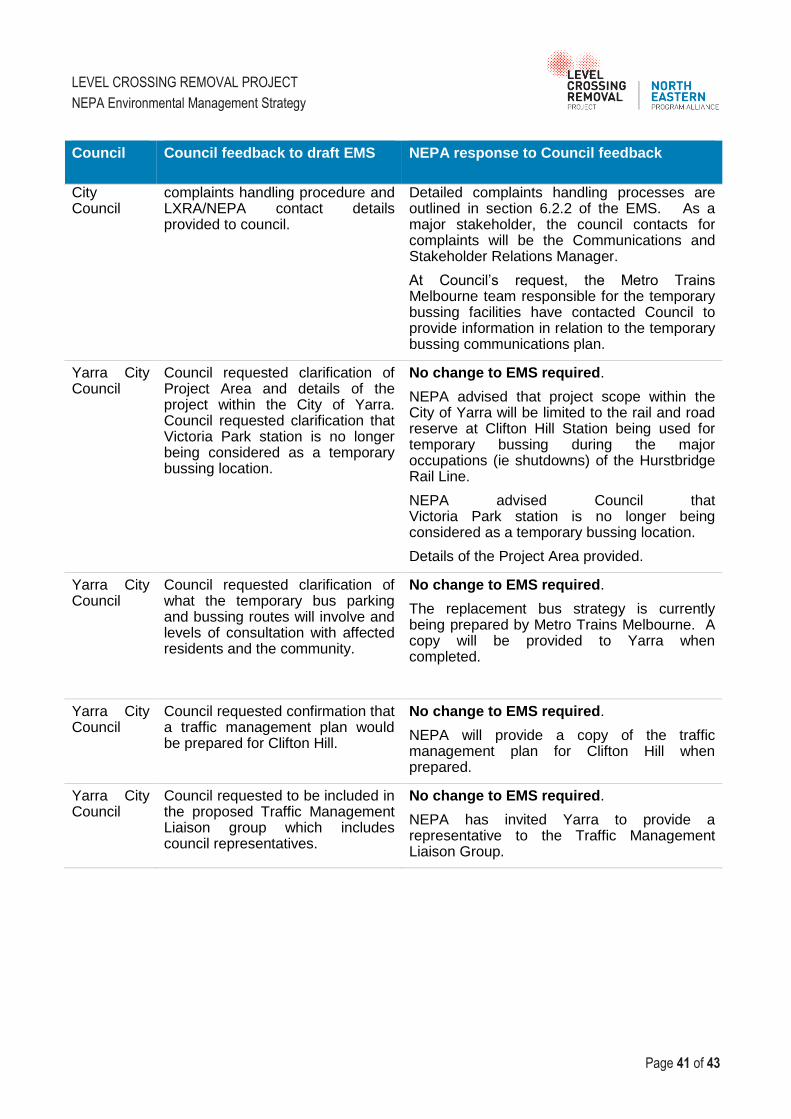
LEVEL CROSSING REMOVAL PROJECT
NEPA Environmental Management Strategy
Page 41 of 43
Council Council feedback to draft EMS NEPA response to Council feedback
City Council
complaints handling procedure and LXRA/NEPA contact details provided to council.
Detailed complaints handling processes are outlined in section 6.2.2 of the EMS. As a major stakeholder, the council contacts for complaints will be the Communications and Stakeholder Relations Manager.
At Council’s request, the Metro Trains Melbourne team responsible for the temporary bussing facilities have contacted Council to provide information in relation to the temporary bussing communications plan.
Yarra City Council
Council requested clarification of Project Area and details of the project within the City of Yarra. Council requested clarification that Victoria Park station is no longer being considered as a temporary bussing location.
No change to EMS required.
NEPA advised that project scope within the City of Yarra will be limited to the rail and road reserve at Clifton Hill Station being used for temporary bussing during the major occupations (ie shutdowns) of the Hurstbridge Rail Line.
NEPA advised Council that Victoria Park station is no longer being considered as a temporary bussing location.
Details of the Project Area provided.
Yarra City Council
Council requested clarification of what the temporary bus parking and bussing routes will involve and levels of consultation with affected residents and the community.
No change to EMS required.
The replacement bus strategy is currently being prepared by Metro Trains Melbourne. A copy will be provided to Yarra when completed.
Yarra City Council
Council requested confirmation that a traffic management plan would be prepared for Clifton Hill.
No change to EMS required.
NEPA will provide a copy of the traffic management plan for Clifton Hill when prepared.
Yarra City Council
Council requested to be included in the proposed Traffic Management Liaison group which includes council representatives.
No change to EMS required.
NEPA has invited Yarra to provide a representative to the Traffic Management Liaison Group.

LEVEL CROSSING REMOVAL PROJECT
NEPA Environmental Management Strategy
Page 42 of 43
7 PERFORMANCE MONITORING AND REPORTING
7.1 Performance Monitoring
Environmental performance will be monitored utilising a variety of tools to ensure that the
requirements of this Strategy, planning and environment approvals and the Environmental
Management Framework are achieved. In summary, performance monitoring will include:
regularly reviewing compliance with planning and environment approvals;
audits of the EMP and CEMP;
environmental monitoring (for example water quality, noise, etc.) as required by the CEMP, monitoring results will be used to identify potential or actual problems arising from construction processes and confirm rectification measures are effective;
inspections of the works to ensure environmental controls are in place and effectively managing identified risks; and
surveillance of work activities and subcontractors will be undertaken on a day-to-day basis by superintendents, foremen and engineers to ensure environmental requirements are being implemented.
7.2 Reporting
Monthly Performance Reports will be issued to LXRA as part of NEPAs Leadership Team Monthly
Report in accordance with the Project Alliance Agreement (PAA). This is a contractual requirement
of the project. Reporting will include progress on environment and sustainability elements. These
reports will include details of:
status of current and planned works, key environmental issues and management measures;
records of compliance with planning and environment approvals;
details of environmental complaints or incidents and corrective and preventative actions taken;
summary of any consultation with regulatory authorities or other stakeholders;
environmental training completed;
audits conducted (internal and external) and a summary of the outcomes;
innovations and achievements;
monitoring and inspection results; and
waste, fuel and energy use information as required.
Any environmental issues will be raised through this reporting and provided to the Project
Environment and Sustainability Manager for review.
A summary of the type and number of enquiries and complaints received will be reported to LXRA
via the Communications and Stakeholder Relations weekly report.
Relevant environmental incidents will be reported within agreed timeframes as detailed in the CEMP
to LXRA and regulatory agencies if required.

LEVEL CROSSING REMOVAL PROJECT
NEPA Environmental Management Strategy
Page 43 of 43
8 DOCUMENT CONTROL AND UPDATE
The master ‘controlled’ Construction Environment Management Plan (CEMP) document will be held
within the Project’s document management system (Teambinder) where it can be accessed by
personnel as necessary.
All paper copies of this CEMP will be considered as ‘uncontrolled’ unless they have been allocated
a ‘copy number’ in a colour other than black.
The personnel or key stakeholders to whom these copies have been issued will be sent
amendments as they occur (following Minister of Planning approval), and it is their responsibility to
discard superseded pages and insert new pages.
8.1 Issue, Revision and Re-issue
The initial issue of this plan has been reviewed by the Regional Environmental Manager to ensure it
meets the requirements of LORs Environmental Management System and policy, contract,
specifications and standards. The plan is approved internally for use on the project by the ALT and
approved to the satisfaction of the Minister of Planning, or delegate, but will also be prepared
through consultation with relevant council authorities. Evidence of initial review and approval by the
Alliance Management Team and Alliance Leadership is by signatures on the cover sheet.
Revisions of this CEMP may be required throughout the duration of the project to reflect changing
circumstances or identified deficiencies.
Revisions may result from:
Management review
Audits (either internal or by external parties)
Client complaints or non-conformance reports
Major incidents or regulatory action
Revisions shall be reviewed and approved by the relevant parties (i.e. AMT and ALT along with a
final review and approval by the Minister of Planning prior to issue. Updates to this plan are
numbered consecutively and issued to holders of controlled copies.