lind et al - digital infrastructures for enabling sea...
TRANSCRIPT

The 10th International Symposium ISIS 2014 “Integrated Ship’s Information Systems“
Related ISIS 2014 Topics: “Functional Integration Aboard and Ashore” or “E-‐Navigation Processes”
Digital Infrastructures for enabling Sea Traffic Management Mikael Lind1, Anders Brödje2, Richard Watson3, Sandra Haraldson4,
Per-‐Erik Holmberg5, Mikael Hägg6
1 Corresponding Author, Viktoria Swedish ICT, Gothenburg, Sweden +46 70-‐566 40 97, [email protected]
2 Swedish Maritime Administration, Gothenburg, Sweden [email protected]
3 University of Georgia, Georgia, USA [email protected]
4 Viktoria Swedish ICT, Gothenburg, Sweden [email protected]
5 Viktoria Swedish ICT, Gothenburg, Sweden per-‐[email protected]
6 Chalmers University of Technology, Gothenburg, Sweden [email protected]
Abstract
The paper discusses the digital infrastructures needed for establishing Sea Traffic Management (STM) and its communication and functionalities requirements. STM emerged as a central goal of the MONALISA project and has since been further developed in the ongoing MONALISA 2.0 project. The three key objectives of STM are to increase shipping industry efficiency, improve safety, and reduce environmental impact. MONALISA 2.0 takes a holistic approach to the maritime domain by developing a means for the sharing of information in order to distribute, elaborate, and process common data within the whole transport chain. Through increased digital connectivity and information systems (IS), STM will be further advanced by the development of new tools enabling more efficient planning, booking, monitoring of sea traffic, including both cargo and passenger transport. It is crucial that these shared information systems are developed in a common manner. Experiences from the EU-‐project SESAR, within the air domain, are a guide to finding the safest and most cost effective solutions for the maritime domain. As a carrier of information, a unique voyage id will provide the linchpin for efficient cross-‐sectorial modality and the real time sharing of maritime and other relevant information.
1. Background Within the waters of the European Union – one of the world’s major consumer markets – there are some 29,000 calls to ports on a yearly basis, generating some 580,000 individual vessel movements per year within the territorial waters of EU member states (EMSA, 2011). A cost-‐benefit analysis carried out within the MONALISA project, indicates that an average reduction of 1% sailed distance per ship within the Baltic Sea Region, would save approximately € 100 million on a yearly basis for traffic sailing in the region. Approximately half of the savings are due to less emissions cost for society, and the other half are fuel and other costs for the ship owners (Andersson & Ivehammar, 2014). Baltic Sea traffic makes up approximately 10% of the European total sea traffic (Stankiewicz, Backer, & Vlasov, 2010), and these finding give an indication of the potential savings within European shipping.
The MONALISA project, 2010-‐2013, has shown that supplying vessels with the capability of seeing each other’s planned routes gives the navigator a more complete picture of how surrounding vessels are planning their onward voyage (Porathe, 2012; Porathe, de Vries, & Prison, 2014). Also, shore side services are able to retrieve valuable information as well as supply vessels with advice on their routes. Such advice could be in the form of recommendations to avoid congestion in areas with high traffic, advice on environmentally sensitive areas and Maritime Safety Information.

The 10th International Symposium ISIS 2014 “Integrated Ship’s Information Systems“
Further, the MONALISA project has also demonstrated that implementing route optimization on a full scale in sea transport should result in increased environmental sustainability as well as reduced energy costs and increased safety. A voyage optimization tool, developed within the MONALISA project, can reduce bunker consumption up to 12% for the average vessel. This voyage optimization tool has been tested and verified for traffic sailing in the Baltic Sea in which historical Automatic Identification System (AIS) data has been used for analysis. In order to optimize the route for each individual ship, the voyage optimization tool uses high resolution chart data and ship dimensions, current loading condition, and so forth (Markström & Holm, 2013).
Vessel movements within EU waters, or anywhere in the world for that matter, generate a flow of information in the various stages of each single movement. For instance, information is often required by Vessel Traffic Services, Custom Authorities, and ship and cargo owners. Information also flows among vessels moving within the same geographical area (Brodje, Lützhöft, & Dahlman, 2010).
At the center of the information flow is most commonly the ships master, which is best visualized in figure 1 (Svedberg, 2013). The shipping master is at the center of the current information flow within the shipping industry. This is a heavy and time consuming burden for a ship’s master. Handling this information flow competes for the master’s attention to such critical tasks as navigational safety.
A vessel’s voyage information is produced as well as held by a number of institutions, organizations, and individuals (see Figure 1). These stakeholders all have different and sometimes diverging interests in the shipping industry (Österman, 2012) due to their various areas of business. The ship’s master often facilitates the information flow between these stakeholders while the ship is at sea. As the ship nears its port of destination, the information flow often moves somewhat towards a shore based ship agent. In both cases, most information commonly retrieved and distributed manually by the use of emails and phone calls. The digitization of shipping information is very much in its infancy. At sea, satellite communication is used and often sparingly because of the cost.
There are many and diverse information producers. For example, they include linesmen at the quay preparing for the arrival of the ship, the person preparing the loading hose on an oil pier, and the designated contact in a shipping company. In all cases, multiple stakeholders typically have a need for information derived from other stakeholders involved in the successful and safe execution of a particular sea voyage.
A typical piece of information needed by many stakeholders is the Estimated Time of Arrival (ETA) of a vessel to its port of destination. For the maritime pilots, this information is crucial for the planning the ready availability of a pilot to take the ship to port. Other stakeholders heavily dependent on the ETA of a vessel are the Port as such, the stevedores, Vessel Traffic Service (VTS), and the ship and cargo owners. Other types of information may relate to the particular kind of goods loaded onboard a vessel, which is of crucial interest for safety authorities, customs, and the port.
Over the past 10 years, parts of shipping have been introduced to the automation of information exchanges through the adoption of AIS. One of the system’s major purposes is to serve as an aid for
Figure 1: The information flow to/from a vessel

The 10th International Symposium ISIS 2014 “Integrated Ship’s Information Systems“
navigators to increase their situational awareness through the automatic exchange of certain information on a ship’s static and dynamic data. The information is exchanged between ships sailing in the same limited geographic area (IMO, 2014). Over time, AIS has come to be more integrated into various onboard applications. The information is fused with such information as the ship’s position on an electronic chart, allowing the navigator to better understand the current surrounding situation by having data about nearby vessels. Though a provider of data about the current situation, AIS does not provide detail on a ship’s future movement. It does, however, have an embryonic possibility to specify the intention of a vessel by allowing the navigator to specify the port of destination (which is a requirement by the International Maritime Organization). This information is however not sufficiently detailed since it does not signal any information about expected route and time of arrival. In practice, this means that very few of the receivers of the information know the intentions of the vessels in their domain of interest.
AIS is widely used in many shore-‐based applications, for instance VTS (IALA, 2008). VTS personnel use the information provided by AIS, often fused with radar information, to monitor the current traffic situation. From this, although not provided by the system information, experienced VTS operators can predict how the traffic situation will look some time into the future based on pattern recognition (Brodje et al., 2010). Yet, the effects of a single vessel on other vessels’ voyages or the flow of goods as such cannot be optimized by using the information obtainable from a single vessel. Nor can the information available for VTS be used to optimize the flow of sea traffic or goods as a whole, since VTS are only responsible for the traffic situation in limited geographical areas. Also, AIS information has come to serve as one of the major sources for retrieving ship positions in order to estimate a ship’s possible arrival time at a port. However, even though the information from AIS is widely available on websites such as www.maritimetraffic.com, estimating a time of arrival using the information available from AIS requires a number considerable manual work.
In other logistic domains, IS solutions have been widely adopted with the goal of increasing data flow, diversity, and quality, and overcoming the limitations of manually processing information. As a result, they are able to achieve higher efficiencies in the flow of goods and passengers. A well-‐known example is the European SESAR program within aviation, aiming to achieve flow optimization while at the same time reducing the environmental effects of aviation as well as raising safety levels (EU, 2014). MONALISA’s goal is to achieve similar outcomes within the context of the shipping industry.
This paper presents a design for digital infrastructure needed for the development Sea Traffic Management, with the objective of providing seamless and automated information flows for optimizing shipping and the flow of goods through the shipping part of the logistics chain. We will start by introducing the concept of Sea Traffic Management. This will be followed by an introduction of the four sub-‐concepts of Sea Traffic Management: Strategic Voyage Management, Dynamic Voyage Management, Flow Management, and Port CDM (Collaborative Decision Making). This is followed by the introduction of SWIM (System Wide Information Management) as the enabling digital infrastructure necessary for the realization of Sea Traffic Management and its four sub-‐concepts. This will in turn be followed by some concluding remarks.
2. The goal Sea Traffic Management (STM)
2.1 Increased collaboration in the sea transport ecosystem enabled by STM
Sea Traffic Management (STM) is a proposed concept for enabling a higher degree of integrated performance within the sea transport ecosystem. Its goal is to increase safety, environmental sustainability, and operational efficiency of sea transport. STM relies upon involved actors sharing their short-‐ and long-‐term intentions (e.g., estimates of when a state is to be reached) as well as information about reached states. STM is realized by four key concepts, 1) Strategic Voyage Management (SVM) and 2) Dynamic Voyage Management (DVM), 3) Collaborative Decision Making within and in relation to ports (Port CDM) and 4) Flow Management, all supported by a fifth concept; 5) a system wide information management (SWIM) sharing of data in a common information
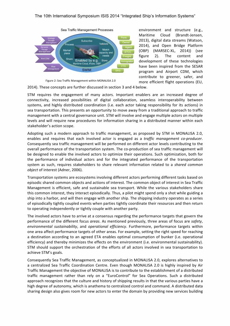
The 10th International Symposium ISIS 2014 “Integrated Ship’s Information Systems“
environment and structure (e.g., Maritime Cloud (Brandt-‐Jensen, 2013), digital data streams (Watson, 2014), and Open Bridge Platform (OBP) (MARSEC-‐XL, 2014)) (see figure 2). The content and development of these technologies have been inspired from the SESAR program and Airport CDM, which contribute to greener, safer, and more efficient flight operations (EU,
2014). These concepts are further discussed in section 3 and 4 below.
STM requires the engagement of many actors. Important enablers are an increased degree of connectivity, increased possibilities of digital collaboration, seamless interoperability between systems, and highly distributed coordination (i.e. each actor taking responsibility for its actions) in sea transportation. This presents an opportunity to move away from a traditional approach to traffic management with a central governance unit. STM will involve and engage multiple actors on multiple levels and will require new procedures for information sharing in a distributed manner within each stakeholder’s action scope.
Adopting such a modern approach to traffic management, as proposed by STM in MONALISA 2.0, enables and requires that each involved actor is engaged as a traffic management co-‐producer. Consequently sea traffic management will be performed on different actor levels contributing to the overall performance of the transportation system. The co-‐production of sea traffic management will be designed to enable the involved actors to optimize their operations. Such optimization, both for the performance of individual actors and for the integrated performance of the transportation system as such, requires stakeholders to share relevant information related to a shared common object of interest (Adner, 2006).
Transportation systems are ecosystems involving different actors performing different tasks based on episodic shared common objects and actions of interest. The common object of interest in Sea Traffic Management is efficient, safe and sustainable sea transport. While the various stakeholders share this common interest, they interact episodically. Thus, a pilot might spend only a shot while guiding a ship into a harbor, and will then engage with another ship. The shipping industry operates as a series of episodically tightly coupled events when parties tightly coordinate their resources and then return to operating independently or tightly couple with another party.
The involved actors have to arrive at a consensus regarding the performance targets that govern the performance of the different focus areas. As mentioned previously, three areas of focus are safety, environmental sustainability, and operational efficiency. Furthermore, performance targets within one area affect performance targets of other areas. For example, setting the right speed for reaching a destination according to an agreed ETA enables optimal consumption of bunker (i.e. operational efficiency) and thereby minimizes the effects on the environment (i.e. environmental sustainability). STM should support the orchestration of the efforts of all actors involved in sea transportation to achieve STM’s goals.
Consequently Sea Traffic Management, as conceptualized in MONALISA 2.0, explores alternatives to a centralized Sea Traffic Coordination Centre. Even though MONALISA 2.0 is highly inspired by Air Traffic Management the objective of MONALISA is to contribute to the establishment of a distributed traffic management rather than rely on a “EuroControl” for Sea Operations. Such a distributed approach recognizes that the culture and history of shipping results in that the various parties have a high degree of autonomy, which is anathema to centralized control and command. A distributed data sharing design also gives room for new actors to enter the domain by providing new services building
Figure 2: Sea Traffic Management within MONALISA 2.0

The 10th International Symposium ISIS 2014 “Integrated Ship’s Information Systems“
on data made available from the various stakeholders. Hence, STM favors a cooperative and coordinating model of data sharing which fits the historical modus operandi and culture of shipping.
As inspired by Svallvåg 2013 (Södahl, Hanning, Hult, Garme, & Hindrum, 2013), information sharing for STM in Intermodal Sea Transport could be expanded to include other transport means and thereby cover multimodal transport processes (c.f. figure 3). Hence, Sea Traffic Management needs to
become an integral part of the (distributed) management of the total chain of operations in multimodal transportation processes. The proposed distributed data sharing design can readily accommodate the inclusion of more stakeholders as higher levels of integration are sought.
Inspired by the definition of e-‐Navigation by IMO, the initial STM definition by the Swedish Maritime Administration, and the thoughts of modern traffic management as a distributed phenomena document, the following definition of Sea Traffic Management (Lind, Fagerhus, Hägg, & Svedberg, 2014) is proposed within MONALISA 2.0:
Sea Traffic Management (STM) is a concept encompassing all actors, actions, and systems (infrastructure) assisting maritime transport from port to port. STM is a part of the multimodal logistics chain, encompassing sea as well as shore-‐based operations. STM is a network-‐based approach for optimal Intermodal Sea Transport. STM is performed on multiple actor levels, where each engaged actor co-‐produces traffic management. These actors contribute to the integrated performance of the realization of the performance targets of intermodal Sea Transport as the shared common object of interest of the ecosystem constituting Sea Transport. STM puts an emphasis on interoperable and harmonized systems allowing a vessel to operate in a safe and efficient manner from port to port with a minimal impact on the environment. STM secures sea traffic flow and capacity optimization.
2.2 Information sharing processes in STM
Various operational (acting) units, key actors, are engaged in sea transportation, where all operations highly influence the performance of the ecosystem as a whole. Each operational unit is seen as a “point of interest” collecting several actors acting on behalf of this “point of interest”. Examples of “point of interests” related to sea traffic management are vessels, ports, authorities, and ship-‐
owners. These points of interests involve numerous actors that provide and utilize information to perform their tasks. Optimally, each operational unit manages data sharing between different actors by collecting information from providers and enabling information utilizers to access needed data. This means, for example, that ships would collect all relevant information from different sources on-‐board (e.g., the engine, the bridge etc.), distribute the obtained information to different personnel on-‐board the vessel as well as to other operational units on other vessels or onshore. Collaborative data sharing by all parties is an essential key success factor. An ecosystem, where the performance of an individual party
relies on the integrated performance of different entities, requires that information is exchanged between entities efficiently and seamlessly (see figure 4 (Lind et al., 2014a)). The ecosystem for STM is depicted in Figure 5 (Lind et al., 2014a).
Within MONALISA 2.0 schemas for information collaboration are being developed with the intention of enabling each unit to act in an optimal way to fulfill its goals and thus the goals of the ecosystem. The distributed nature of sea traffic management requires that each operational unit, and its sub
Figure 4: Distribution of information within and between acting units
Figure 3: Intermodal Sea Transport as part of Multimodal Transport

The 10th International Symposium ISIS 2014 “Integrated Ship’s Information Systems“
units, acts in such way that the performance targets of the ecosystem are reached. Schemas of collaboration require the identification of 1) “key” operational units, 2) key data to exchange/share (including standards), as well as conditions for the exchange of information.
The voyage order is the backbone of the process of information exchanges within STM (See Figure 6 for an illustration of information sharing processes within STM). A particular voyage is initiated by a voyage order directed to the vessel from the operator (e.g., the shipping company or the
charterer). This order includes a unique voyage number (Voyage-‐ID), which will be used to identify the voyage, and store information related to its performance, throughout its different steps. Access rights will be granted to different actors to the data associated with a voyage. This is done based on who is involved with the specific voyage (the relevant Sea Traffic Coordination Centre (STCC), VTS, ports etc.). This means, for example, that the relevant STCC will automatically have access to relevant data for vessels with a route passing through its area of operation.
Figure 6: Information sharing processes within STM
For the vessel operator, the voyage order forms the basis for providing a dynamic voyage plan transferred through a Maritime Cloud (based on information in the ECDIS system). The design idea of STM is that this dynamic voyage plan is published in a maritime cloud (supported by SWIM). Additional information related to the voyage is continuously updated/confirmed through continuous automated position reports, also leaving the necessity for noon and arrival reports obsolete. This dynamic voyage plan also consist of several ETA’s, as an ETA-‐table, for different waypoints as well as the ETA for the destination.
Figure 5: Information exchange in Sea Transports

The 10th International Symposium ISIS 2014 “Integrated Ship’s Information Systems“
In Sea Traffic Management this (published) dynamic voyage plan (including the ETA-‐table) is used as basis for a STCC to propose optimized route (including time slot allocation with speed adjustments) for the vessel to take in order to reach its destination at the expected time. Proposed routes from the Dynamic Route Planning Process (managed by a STCC) and other influencing factors are the basis for updating the dynamic voyage plan (potentially this proposed route is also confirmed back to a STCC by the vessel). Note that STCC is one basis for providing optimization of the voyage plan. The Captain and the shipping company might also use other suppliers of information for voyage optimization. This means that the decision of changing a published voyage plan will be made by the Captain.
The port of destination will subscribe to data that are related to the port. The time of when the first ETA notification reaches the port, triggers the “ETB (Estimated Time of Berth (ALL FAST)) generator” to generate an instance of an ETB tree. In parallel, the “ETD (Estimated Time of Departure) generator” generates an instance of an ETD tree. Actors subscribe to relevant measures enabling them to bid for, agree upon, and plan for future operations.
These trees consist of numerous states requiring actions, performed by different actors, necessary to be completed to enable berthing. This tree could/does (partly) form a market place for some actors to bid on the realization of different actions to reach these states (such as towing the vessel to berth). During the sea voyage, we envisage a continuous bidding and agreement process for the different states to become confirmed. This approach would enable a market place and potentially encourage some competition among the different actors at ports where resources are under-‐utilized.
The ETB (and its status) will be continuously published in the maritime cloud as part of SWIM. A vessel will continually be informed of (updates of) the ETB and its status through its subscription to the maritime cloud. The closer in time that the ETB is in relation to the actual time, the precision of the ETB (= +/-‐ X in time would be narrowed) is expected to be higher. The ETB and the ETD with its statuses also forms the basis for the STCC to provide optimal (alternate) routes in its flow management procedures (see below).
The consequences of this information sharing would enable that:
1. planning of the operations for enabling high berth efficiency ETD – ETB as fast as possible could be initiated as early as the first voyage plan is submitted and published
2. the status of the planning / agreement process concerning ETB and ETD will be published continuously for others
3. actors enabling berthing (with the state of “All Fast” as the end state of berth) and Departure (with the state of “All Loose” as the end state of Departure) would be committed to established terms of condition enabled by an open market place
4. green steaming (inspired from the concept of slow and right steaming) would be enabled by route optimization and highly accurate ETB and ETD
5. the accuracy of ETB and ETD will be higher and thereby enabling management of multiple instances of berthing and cargo operations in a seamless and smooth way
3. Four concepts enabling STM
We now provide a short description of the four operational concepts of STM needing a digital infrastructure for their realization.
3.1 Strategic Voyage Management
In order to provide vessel operators with vital and necessary information, to meet the needs of performing the most cost-‐efficient and environmentally sustainable passage at sea, it is important to create a dynamic flow of information. This can be updated in real time, immediately after changes of state, wherever in the transport-‐chain a change occurs. Voyages making use of the advantages STM are normally initiated by providing input to a voyage-‐planner connected to the STM network. Based on the nature of the input made to the voyage-‐planner the system will immediately make information available relevant to the plan for different actors. This could, for example, concern a

The 10th International Symposium ISIS 2014 “Integrated Ship’s Information Systems“
vessel loaded with dangerous goods. As a result, the system will show information on restricting regulations along the route or that the vessel is required to use a pilot when approaching the desired port. This requirement will immediately be known to the one making input to the voyage-‐planner.
When the voyage plan is completed it is ready for nautical validation, service booking and confirmation and finally execution (actual voyage taking place). When a voyage plan is “released” by the planner -‐ the different service providers like port authorities, pilot services, VTS centers, are made aware of the voyage and are requested to validate and confirm the part of the plan that relies on them. The port authority’s administration system is connected to the STM and should confirm or decline the request, or even suggest changing the plan for arrival and departure (see following port CDM). The planner will then be able to observe as the different service providers responds to the plan. Finally, through collaborative work the plan is ready for “execution” and the dynamic phase of the voyage starts (see dynamic voyage management below).
The voyage planner will also enable the establishment of a STM Maritime Marketplace. Such a marketplace is necessary for the planner, at the earliest possible stage, to make high quality decisions and identify the maritime-‐service-‐provider which best serves the ship’s need. When a cargo owner needs his cargo transported by sea, there are normally several maritime transport companies able to take care of this need. The STM maritime marketplace is a way to connect a cargo owner’s request directly to all relevant transport companies to find the best suitable and affordable option. Transport companies, on the other hand, needs their cargo vessels fully loaded to achieve the best return on their voyage investment. The market place is available for them to make their free capacity known for all cargo owners.
In order to present all available options to the STM participant and optimizing the use of capacity in every vessel, the design of the STM Marketplace needs a digital infrastructure which will enable all concerned stakeholders to engage. When connected the individual planner, as well as the industry as a whole, will be able to reduce administration and increase both efficiency in operations and the utilization of their available capacity.
3.2 Dynamic Voyage Management
To provide ship operators with vital and necessary information to compute the most cost-‐efficient and environmental friendly passage at sea, it is important to create a dynamic flow of data that can be updated in real time, immediately after changes of state, wherever in the transport chain a change occurs. The Dynamic Voyage Plan is an iterative phenomenon, sharing information in real time, updating voyage plans between involved parties in order to improve safety, efficiency and environmental performance by providing new possibilities for validation, optimization, navigational assistance and situational awareness. The first three are services and the latter is a tool used in vessel-‐to-‐vessel communication provided by the technical enabler Route Exchange. Strategic Voyage Management and Dynamic Voyage Management are parts of the STM overall Voyage Management processes. The relationship between these two voyage management processes are visualized in figure 7 (Svedberg & Andreasson, 2014) below.
Associated with Dynamic Voyage Management, there are several services, including: • Route Optimization
Public data stream services provided by different entities to support route optimization, including weather, ice conditions, Maritime Safety Information (MSI), Maritime Spatially Planned areas (MSP), distance, speed, traffic congestion and bathymetric conditions. The route optimization is an iterative process and can be performed both pre-‐departure and continuously enroute as needs and conditions changes. All plans can and must be changeable with short notice, and as soon as new orders and optimizations are completed a new agreement must be established and distributed.

The 10th International Symposium ISIS 2014 “Integrated Ship’s Information Systems“
• Route Validation (STCC) The intended voyage plan is sent to a STCC for validation, which can be done before a vessel’s departure or before arrival at a STCC area. The validation control includes, but is not limited to, primarily an Under Keel Clearance (UKC), air draft check, no violation of MSP no-‐go areas, MSI and compliance with mandatory routing. No optimization service as such is included in route validation.
• Assistance Services for route support In addition to monitoring, passive and automatic surveillance for detecting deviation from agreed routes, provided by Flow Management (see following) a voluntary Assistance Service for route support at various levels can be provided via the exchange of routes between a vessel and STCC.
Figure 7: Linking Strategic Voyage Management to Dynamic Voyage Management
3.3 Flow Management
Flow Management (FM) focuses on the whole traffic flow. The overall objective is to optimize and increase safety of sea traffic flow during all planning and executing phases. While Voyage Management deals with one instance, Flow Management deals with multiple instances. Optimizing traffic is achieved by coordination, not control, hence always leaving the final decision to the Master, and using STM technical enablers. The FM concept should not contradict any regulation on navigational safety, such as COLREG (the International Regulations for Preventing Collisions at Sea). Authorities appointed by National Competent Authority (NCA) of Flag States will solely provide FM services. Port Control (existing organization), Vessel Traffic Service (VTS) (existing organization), and Sea Traffic Management Coordination Center (STCC) (New organization necessary for realizing STM) will provide FM. Associated with Flow Management, there are several services provided, including: • Traffic image for common situational awareness
The establishment and continuous updating of a traffic image over geographical areas constitutes the base for FM. Hence, this is a necessary support feature for the other services. Today, real-‐time traffic images are established within VTS and Port areas. In EU coastal waters, a near-‐time traffic image is established by the SafeSeaNet module STIRES. Still, in most cases a STCC real-‐time traffic image will need to be established.

The 10th International Symposium ISIS 2014 “Integrated Ship’s Information Systems“
• Single ship reporting area In several earlier studies, seamless ships reporting within the EU has been mentioned and proposed. A STCC area, as defined above, could potentially be implemented similar to a large scale Ship Reporting System (SRS). The objective is to perform ship reporting at an entrance point, which is distributed to all stakeholders, such as VTS, involved along the route. Ship information is transmitted together with route information. Ship information will also be automatically handed over to the next STCC area.
• Enhanced monitoring in critical areas All ships participating in STM will have the ability to follow pre-‐planned routes that could be automatically or manually monitored and assisted from the STCC along the route. Deviations from an agreed route will be detected and measures taken when appropriate. Hence, the system will automatically detect if a ship is leaving its intended track or if a non-‐participating ship is maneuvering in “strange patterns”.
• Area management (dynamic No-‐Go areas, MSI connected to specific areas) The exchange of route information and dynamic geo-‐locations opens up new possibilities for area management. A geographical area, which is considered to be a sensitive during specific periods of time, can dynamically be classified as a restricted or no-‐go-‐area. This area will be visible in Electronic Nautical Charts (ENC) and considered during route checking and route optimization.
• Traffic synchronization and capacity management Route optimization could potentially consider traffic in congested waters. Hence, some kind of traffic synchronization service will be needed in order to manage all already planned voyages and synchronizing those with new voyages. This is mainly performed by using the concept of the ETA window, setting the safe haven in the long track direction and Dynamic separation setting the safe haven in the cross track direction.
• Arrival/departure management at ports (ETA/ETD optimization) Vessel traffic in port and quay planning are important input to the overall ETA/ETD optimization process. This type of planning is conducted today; either by a VTS center offering a Traffic Organization Service or, which is more common, a Port Control function. This planning activity and information exchange is covered by the FM service arrival/departure management at ports. This FM service overlaps with the services of Port CDM (e.g. ETB and ETD generators).
3.4 Port CDM
Ports, serving as departure and arrival hubs for different means of transportation, require a coordinated transportation system addressing the goals of the transport system as a whole with smooth and seamless operations at sea, at port (reaching the port, departing from port, performing loading and unloading operations –and sometimes other maintenance and extraordinary administrative tasks) as well as connections to hinterland transportation. Seamless and sustainable transport enabled by sea traffic management requires a collaborative port. Inspired by airport CDM, Port CDM has been identified as a key enabler for reaching the full potential of sea traffic management. The purpose of port CDM is to provide a basis (processes, content etc.) for the collaboration between key actors within the port and between the port and its surroundings. The overall goal of Port CDM is to support just-‐in-‐time operations within ports and in relation to other actors being coordinated by an efficient and collaborative port. Port CDM constitutes the interface between ports and STM. One driver for Port CDM is to enable high accuracy in predictability leading to, among other effects, optimal berth productivity (as the number of cargo operations divided by the time at berth) (Tirschwell, 2013). Thus, essential boundary objects between sea and port are Estimated/Actual Time of Berth (ATB/ETB) and Estimated/Actual Time of Departure (ATD/ETD). ATB is defined as the time when the vessel is All Fast (at berth) and ATD as the time when the vessel is All

The 10th International Symposium ISIS 2014 “Integrated Ship’s Information Systems“
Loose (from berth). Governance towards ETB and ETD give rise to green / slow steaming as well as reducing unnecessary waiting times enabling substantial environmental and financial effects.
Port CDM functions for enabling four collaborative arenas enabling sustainable transports as a whole (c.f. Figure 8) (Lind et al, 2014b). Within each collaborative arena, Port CDM should support the development of efficient operations (e.g. integrating processes in the port (collaborative arena #1) so that the port is prepared for arriving ships, creating conditions so that a sea voyage will be as efficient as possible (just-‐in-‐time arrival) (collaborative arena #2) etc.). Port CDM, as a common measurement, collaborative decision, and information sharing system would support the integration of different processes and enable areas of collaboration to be performed with high efficiency resulting in just-‐in-‐time operations within and between the collaborative arenas.
In order for the port to optimize its operations, it is essential to receive real-‐time information of the status, together with updated estimates, of different transports that are affecting the operations at port. This means that the same measures functions both as coordination mechanisms for optimizing port operations (and creating readiness for managing necessary loading/unloading operations) and as boundary objects for other actors outside the port for their optimization. These measures are at the core related to data being shared and the agreements being made within the collaborative arenas identified above. The measures are used for giving estimates (such as Estimated Time of Birth (ETB) and Estimated Time of Departure (ETD) as two essential boundary objects), giving actual times of when certain times have been reached, and a basis for evaluation.
Port CDM builds upon different measures used as a basis for information sharing and making agreements around, such as Estimated Time of Arrival (ETA) and Estimated Time of Departure (ETD), where the overall goal is to arrive as close as possible to the provided ETA (ETx – ATx should be as close to zero as possible). The resulting deviation represents the predictability of the port as such (as a representation of an ecosystems of actors), and represents a measure of how well a port performance in a synchronized transport chain (enabled by STM). This in turn would enable different actors to optimize their operations and their utilization of physical infrastructure and variable resources. To reach the full effects of STM, and thereby enable sustainable sea transport processes, high accuracy (based on systematic estimation procedures) related to berthing, unloading, loading, and departure, becomes necessary. Reliable estimates for a sea voyage can be established by enabling high accuracy of the arrival, operations at port, and the departure of a vessel. Different planning horizons are associated with different levels of tolerance for deviation between the estimated and actually reached state (the outcome) as depicted in figure 9 (Lind et al, 2014b). The deviation should be diminishing with time; the closer to the Execution Phase the smaller the tolerance for deviation should be, until the actual moment of occurrence is reached for a certain state. This allows for the planning process, performed by the different actors, with different time horizons (i.e., long-‐term, mid-‐term, and short-‐term planning) to be performed optimally, based on
Figure 8: The identification of four collaborative arenas

The 10th International Symposium ISIS 2014 “Integrated Ship’s Information Systems“
information about the interval of the outcome (e.g. a time span of when a certain state is reached). Sea transportation is a multi-‐organizational business with numerous actors positioning and coordinating their performance in relation to different control points. In line with the ambitions of the MONALISA 2.0 project and amongst other factors, STM will be realized by sharing information about the status and values related to identified control points for a particular voyage.
4. Enabling digital streams and collaboration via SWIM
4.1 A distributed view on SWIM
Today, a lot of digital data streams exist in the shipping domain, yet there are no standards for these streams and no central directory for locating them and the associated documentation. As a result, the effective use of real-‐time data for shipping management is fragmented, uncoordinated, and not very efficient. Consequently, an unused potential for the exchange of real-‐time data between key actors exists. Thus, to enable System Wide Information Management (SWIM), an interoperability infrastructure needs to be established to facilitate the exchange of real-‐time data.
“A digital data stream consists of digital elements that describe an event (e.g., a sale, the berthing of a ship), concerning both intentions or the actual occurrence of the event, or the current state of an entity (e.g., the level of humidity in a field, the current mood of a person) that are available real-‐time. The seven basic elements of a digital data stream are the description of when, where, who, what, how, why, and outcome”. (Watson, 2014).
The current situation favors an incremental, market-‐driven approach to the development of SWIM. Step-‐by-‐step, these streams can be standardized, documented, and made available to authorized accounts. As mentioned, data streams are the foundation of SWIM, no matter its design. An incremental approach accelerates speed-‐to-‐operations and avoids trying to design a centralized system whose requirements will change as the value proposition of STM emerges from use and experience. Thus, SWIM becomes a central repository of data stream details.
4.2 Design principles for a distributed SWIM
The SWIM approach for distributed exchange/sharing of real-‐time data enabled by data streams relies on the following design principles: • Digital data streams can be open, proprietary, or hybrid
SWIM cannot rely on a fully open data architecture. The intentions and performance of ship-‐owners operations can represent the competitive edge of the company thus such data can be very sensitive. There are also service providers whose business models build on providing data in a condensed and quality assured way (e.g. IHS-‐Fairplay, Q88.com, Purplefinder).
• Common standardized data format for all data streams in a SWIM repository A data stream that is SWIM-‐enabled (i.e. connected to SWIM) must provide data according to the (SWIM) defined data standard. Though data streams might exist for different sources, in a variety of formats, and serving different purposes, they should be translated into the SWIM standard for data exchange.
Figure 9: Acceptable deviation between estimate and actual occurrence (in different time slots)

The 10th International Symposium ISIS 2014 “Integrated Ship’s Information Systems“
• Standardized API for accessing data streams to support interoperability A data stream provider must provide a stream according to standardized definitions via a standardized SWIM API. A fairly comprehensive inventory of needed data services enabled by SWIM should be developed early in the implementation phase.
• Accessibility: Access to data should be governed by the data stream owner The provider of the data assigns and manages access rights for a specific use of the data distributed in data streams, such as the voyage, to the requestor. Subsequently, there is a need for a central repository of actors/actor-‐types/organizations which can be used by the data provider to assign access rights for the use of the data (i.e., by whom it should be used and under which conditions). In a decentralized model of access control, the data stream owner handles validation.
• Discoverability: The existence of a data stream should be informed by a discoverability mechanism SWIM should contain mechanisms allowing a requester to learn about available data streams and access procedures. This means that a SWIM-‐enabled data stream should be requested to submit the existence of any data related to a certain voyage, vessel etc. to this repository, but not the actual data. There is thus a need for a mechanism pointing at the existence of, and how a particular data stream can be found (e.g. data on a specific voyage, geographic area or port). The discovery mechanism should automate connectivity to the desired data stream. For example, providing a pre-‐formatted message to the stream provider requesting access.
4.3 The advantages of an incremental approach to SWIM
An incremental approach can build upon existing data streams. When a core mechanism is in place, different actors can participate and “SWIMify” their data streams at their pace or that of competitive pressure. Interfaces for enabling access to data are not a revolutionary approach. By constructing these kinds of interfaces the internal structures of the data providing organizations does not have to be changed. For enabling STM, these SWIMified interfaces do however need to be created by each data providing organization. The basic principle for creating SWIM-‐based interfaces from different systems to is depicted in figure 10.
Figure 10: SWIMifying relevant data streams for Sea Traffic Management
The development of an information market should also be facilitated whereby entrepreneurs can aggregate data streams to create information and analytical services (different types of data streams

The 10th International Symposium ISIS 2014 “Integrated Ship’s Information Systems“
could thus be created). The SWIM concept designs the standards, a meta data hub, and a governance mechanism for the shipping industry data stream market. The provision of information is left to shipping industry participants and third parties.
5. Concluding reflections The long history of shipping has created an industry with many autonomous players operating with a high degree of independence but with a need for episodic tight coupling to fulfill individual goals. For example, a ship cannot deliver its cargo without close cooperation with a pilot, tug, and terminal operator. Despite this need for episodic tight coupling, the industry has not undergone the digital transformation that would enable data sharing to make coupling more efficient and reduce costs. Furthermore, we have presented a plan for realizing STM that is highly cognizant of the nature of the industry. We advocate a digital transformation that preserves independence by allowing each party to manage access to its data and to decide when it will join the digital revolution. Our plan is based on creating an open market with complementary standards that facilitates coordination through data streaming and enables existing information intermediaries, such as shipping agents, and new infomediaries, provided by entrepreneurial information services, to adapt and emerge to meet the industry’s information needs. In this paper, we have described a series of digitally-‐based information services centered on STM that will accelerate digital transformation of the shipping industry and provide Europe with more efficient, safer, and environmentally sustainable ship transportation.
References Adner, Ron. (2006). Match Your Innovation Strategy to Your Innovation Ecosystem. Harvard Business
Review. Retrieved from www.hbr.org website: Andersson, Peter, & Ivehammar, Pernilla. (2014). Economic Impacts -‐ Cost Benefit Analysis of
Implementing Dynamic Route Planning at Sea. Norrköping, Sweden: MONALISA Project Bureau.
Brandt-‐Jensen, Erik. (2013, 2013-‐12-‐13). The Maritime Cloud skal dække over skibsfarten. Retrieved 2014-‐07-‐20, 2014
Brodje, Anders, Lützhöft, Margareta, & Dahlman, Joakim. (2010). The Whats, Whens, Whys and Hows of VTS Operators use of sensor information. Paper presented at the International Conference on Human Performance at Sea, Glasgow.
EMSA. (2011). Maritime Accident Review 2010. Lisbon, Portugal: European Maritime Safety Agency. EU. (2014, 2014-‐02-‐26). What is the SESAR project? Single European Sky ATM Research Retrieved
2014-‐07-‐20, 2014 IALA. (2008). IALA -‐ Vessel Traffic Services Manual. Saint Germain en Laye, France: International
Association of Marine Aids to Navigation and Lighthouse Authorities. IMO. (2014). AIS transponders. Retrieved 2014-‐06-‐11, 2014 Lind, Mikael, Fagerhus, Geir, Hägg, Mikael, & Svedberg, Ulf. (2014a). Sea Traffic Management in
MonaLisa 2.0, Preliminary findings within the MONALISA 2.0 project. Norrköping, Sweden: Swedish Maritime Administration.
Lind et al (2014b) Identifying the Scope of Sea Traffic Management: The Interface to Ports Operations, Preliminary findings #1 within the MONALISA 2.0 project
Markström, Lars, & Holm, Henrik. (2013). Voyage optimisation on the shallow waters of the Baltic Sea. SSPA Highlights, 4-‐5.
MARSEC-‐XL. (2014). Open Bridge Platform. Retrieved 2014-‐07-‐20, 2014 Porathe, Thomas. (2012). Transmitting intended and suggested routes in ship operations: cognitive
off-‐loading by placing knowledge in the world. Work: A Journal of Prevention, Assessment and Rehabilitation, 41(0), 4873-‐4878. doi: 10.3233/WOR-‐2012-‐0780-‐4873
Porathe, Thomas, de Vries, Linda, & Prison, Johannes (2014). Ship voyage plan coordination in the MONALISA project: user tests of a prototype ship traffic management system. Paper presented at the Human Factors and Ergonomics Society Europe Chapter 2013 Annual Conference, Torino, Italy.

The 10th International Symposium ISIS 2014 “Integrated Ship’s Information Systems“
Stankiewicz, Monika, Backer, Hermanni, & Vlasov, Nikolay. (2010). Maritime Activities in the Baltic Sea – An integrated thematic assessment on maritime activities and response to pollution at sea in the Baltic Sea Region Baltic Sea Environment Proceedings. Helsinki, Finland: Helsinki Commission.
Svedberg, Ulf. (2013). Sharing of Complex Maritime Information. Paper presented at the e-‐Nav Underway 2013, Copenhagen, Denmark.
Svedberg, Ulf, & Andreasson, Björn. (2014). Concept: Dynamic Voyage Management. Swedish MAritime Administration. Swedish Maritime Administration. Working paper.
Södahl, Björn, Hanning, Andreas, Hult, Carl, Garme, Karl, & Hindrum, Kerstin. (2013). Svallvåg 2013 -‐ Svensk maritim forsknings-‐ och innovationsagenda. Gothenburg, Sweden: Chalmers University of Technology.
Tirschwell, Robert. (2013). Key Findings On Terminal Productivity Performance Across Ports, Countries And Regions. New Jersey, USA: JOC Inc.
Watson, Richard. (2014). Are You Ready to Profit from Real-‐Time Digital Data Streams? MIS Department. University of Georgia.
Österman, Cecilia. (2012). Developing a Value Proposition of Maritime Ergonomics. (PhD), Chalmers University of Technology, Gothenburg, Sweden.