linear referencing an introduction heather mccracken & derek law esri redlands uc 2009 tech...
TRANSCRIPT

Linear ReferencingLinear ReferencingAn IntroductionAn Introduction
Heather McCracken & Derek LawHeather McCracken & Derek LawESRI RedlandsESRI Redlands
UC 2009 Tech SessionsUC 2009 Tech Sessions 11

OutlineOutline
• Fundamental conceptsFundamental concepts• Terminology in ArcGISTerminology in ArcGIS• Query & analysis operationsQuery & analysis operations• Creating & maintaining routesCreating & maintaining routes• SummarySummary
UC 2007 Tech SessionsUC 2007 Tech Sessions 22

OutlineOutline
• Fundamental conceptsFundamental concepts– Define linear referencingDefine linear referencing
– Application examplesApplication examples
• Terminology in ArcGISTerminology in ArcGIS• Query & analysis operationsQuery & analysis operations• Creating & maintaining routesCreating & maintaining routes• SummarySummary
UC 2007 Tech SessionsUC 2007 Tech Sessions 33

What is linear referencing?What is linear referencing?
• Method of storing geographic features by usingMethod of storing geographic features by usingrelative positionsrelative positions along a measured line feature along a measured line feature
UC 2007 Tech SessionsUC 2007 Tech Sessions 44
A307 is 100 miles long. Where is mile 60?A307 is 100 miles long. Where is mile 60?
B7 B7
A307
A307
A45
A45
D23
D23 F478
F478
AA

Why use linear referencing?Why use linear referencing?
• Intuitive way to model relative locations alongIntuitive way to model relative locations alonglinear featureslinear features
– E.g., The concrete road surface starts at mile 5,E.g., The concrete road surface starts at mile 5,NOT The concrete road surface starts at NOT The concrete road surface starts at 3030oo40’25’’N, 9640’25’’N, 96oo22’32’’W22’32’’W
• Enables the association of multiple sets of attributes to portions Enables the association of multiple sets of attributes to portions of linear features without segmenting the underlying line each of linear features without segmenting the underlying line each time attribute values changetime attribute values change
UC 2007 Tech SessionsUC 2007 Tech Sessions 55
mile 5mile 5
3030oo40’25’’N, 9640’25’’N, 96oo22’32’’W22’32’’W
AA

Features using a linear system of measureFeatures using a linear system of measure
• Feature’s location determined using a linear system of measure Feature’s location determined using a linear system of measure values, instead of using x,y coordinatesvalues, instead of using x,y coordinates
UC 2007 Tech SessionsUC 2007 Tech Sessions 66
Main St15
40 60 8095
20
Accident occurred 50
meters along Main St.

Features containing one-to-many relationshipsFeatures containing one-to-many relationships
• Two or more pieces of information associated with the same Two or more pieces of information associated with the same location on a linelocation on a line
UC 2007 Tech SessionsUC 2007 Tech Sessions 77
Railroad
Accidents
Speed45 35 45 55
0 20 40 60 80 100
River
Salmon habitat
Gradient Rapid Slow
Coho Coho/King
0 100
200
300
400500 600
TransportationTransportation
Natural resourcesNatural resources

Features containing frequently segmented dataFeatures containing frequently segmented data
• Some types of features have attributes that change frequentlySome types of features have attributes that change frequently
UC 2007 Tech SessionsUC 2007 Tech Sessions 88
concrete asphaltMaterial
Qualityfair good poor
Main St.15
40 60 8095
20

OutlineOutline
• Fundamental conceptsFundamental concepts• Terminology in ArcGISTerminology in ArcGIS
– RoutesRoutes
– MeasuresMeasures
– EventsEvents
– Dynamic segmentationDynamic segmentation
• Query & analysis operationsQuery & analysis operations• Creating & maintaining routesCreating & maintaining routes• SummarySummary
UC 2007 Tech SessionsUC 2007 Tech Sessions 99

RoutesRoutes
• Linear features – in a polyline feature classLinear features – in a polyline feature class• Must have an Must have an identifieridentifier & & measurement systemmeasurement system• Store in a geodatabase, shapefile, or coverageStore in a geodatabase, shapefile, or coverage
UC 2007 Tech SessionsUC 2007 Tech Sessions 1010
Linear feature
Unique identifier
Route 711081

Route geometry and what can they modelRoute geometry and what can they model
• Route geometryRoute geometry
• Routes can modelRoutes can model
UC 2007 Tech SessionsUC 2007 Tech Sessions 1111
Single part polyline Multi-part polyline
Looping 180-degree turnsBranching

Routes in ArcMapRoutes in ArcMap
• Layer properties > Route tabLayer properties > Route tab• Route IdentifierRoute Identifier
– Uniquely identifies each routeUniquely identifies each route
– Used by all other linear referencing dialogs in ArcGISUsed by all other linear referencing dialogs in ArcGIS
UC 2007 Tech SessionsUC 2007 Tech Sessions 1212

MeasuresMeasures
• The distance along a route from an originThe distance along a route from an origin– Can be miles, meters, feet, time Can be miles, meters, feet, time
• Do not have to be the same units as the x,y coordinatesDo not have to be the same units as the x,y coordinates
– Can increase, remain constant, or decreaseCan increase, remain constant, or decrease
• Route vertices store measure values (M)Route vertices store measure values (M)• NaN (unknown) measures may exist NaN (unknown) measures may exist
– Not a NumberNot a Number
UC 2007 Tech SessionsUC 2007 Tech Sessions 1313
M at every vertex
0.0
1.2
NaN3.7 4.8
4.2

Route locationsRoute locations
• Use a route identifier to locate the appropriate routeUse a route identifier to locate the appropriate route• 2 types2 types
– PointPoint (uses a single measure value) (uses a single measure value)
– Discrete location on a routeDiscrete location on a route
– LineLine (uses (uses from-from- and and to- to- measure values)measure values)
– Describe a portion of a routeDescribe a portion of a route
UC 2007 Tech SessionsUC 2007 Tech Sessions 1414
I10
Accident occurred at mile 23Accident occurred at mile 23
Kenai River
Salmon found between mile 10 and mile 20
Salmon found between mile 10 and mile 20

Event tablesEvent tables
• Route locations thematically stored in tables are called “Route locations thematically stored in tables are called “route route eventsevents” or simply “” or simply “eventsevents””
• 2 types2 types– PointPoint event table event table
• E.g., Accidents, Sample sitesE.g., Accidents, Sample sites
– LineLine event table event table• E.g., Pavement conditions, Riverbank compositionE.g., Pavement conditions, Riverbank composition
• An event can be any type of table supported by ArcGISAn event can be any type of table supported by ArcGIS
UC 2007 Tech SessionsUC 2007 Tech Sessions 1515

Point event tablesPoint event tables
• Two required fieldsTwo required fields– Route IDRoute ID identifies route on which event is located identifies route on which event is located
– MeasureMeasure is the event’s location on the route is the event’s location on the route
• Other attributes about the eventOther attributes about the event
UC 2007 Tech SessionsUC 2007 Tech Sessions 1616
Route location Attributes
Route 1
4
14
34
45
53
0
60

Line event tablesLine event tables
• Three required fieldsThree required fields– Route IDRoute ID identifies route on which event is located identifies route on which event is located
– From MeasureFrom Measure and and To MeasureTo Measure define beginning and end of line event define beginning and end of line event
• Other attributes about the eventOther attributes about the event
UC 2007 Tech SessionsUC 2007 Tech Sessions 1717
Route location AttributesRoute 48
0
25
0
60
AA

Dynamic segmentationDynamic segmentation
• Computing the location of events on routesComputing the location of events on routes– Event locations can change dynamicallyEvent locations can change dynamically
• Locations are interpolatedLocations are interpolated
• Use the Use the MakeRouteEventLayerMakeRouteEventLayer GP tool GP tool
UC 2007 Tech SessionsUC 2007 Tech Sessions 1818
A307 10.2A307A307F478F478A45A45
25.62.59.53.27.1
1103244
ACCTYPEMILE
6543210
OID RKEY
15.5
A45
A307
B7
D23
F478

Event layers are feature layersEvent layers are feature layers
• Created by the dynamic segmentation processCreated by the dynamic segmentation process– Underlying route is not fragmentedUnderlying route is not fragmented
• Event layers behave just like other feature layersEvent layers behave just like other feature layers– Display using custom symbologyDisplay using custom symbology
– Perform GIS analysis Perform GIS analysis
– Save as a layer fileSave as a layer file
– Export to feature classExport to feature class
UC 2007 Tech SessionsUC 2007 Tech Sessions 1919

Routes, measures, eventsRoutes, measures, events& dynamic segmentation& dynamic segmentation
UC 2007 Tech SessionsUC 2007 Tech Sessions 2020
Demo 1Demo 1

OutlineOutline
• Fundamental conceptsFundamental concepts• Terminology in ArcGISTerminology in ArcGIS• Query & analysis operationsQuery & analysis operations
– Route queryRoute query
– Route symbolization optionsRoute symbolization options
– Route events analysisRoute events analysis
• Creating & maintaining routesCreating & maintaining routes• SummarySummary
UC 2007 Tech SessionsUC 2007 Tech Sessions 2121

Find and Identify route locationsFind and Identify route locations
Find:Find: Query a map using Query a map using a route locationa route location
UC 2007 Tech SessionsUC 2007 Tech Sessions 2222
Identify Route Locations:Identify Route Locations: Click on map to determine Click on map to determine route locations route locations
AA
Route: 13000C00158
Measure: 0.5

HatchingHatching
• Line or point marker symbols placed at an interval along a routeLine or point marker symbols placed at an interval along a route– DistanceDistance
• E.g., meters, feetE.g., meters, feet
– Non-distanceNon-distance• E.g, sample sitesE.g, sample sites
• Create & modify hatch Create & modify hatch styles via style managerstyles via style manager
• Import hatches from a Import hatches from a layer file (.lyr)layer file (.lyr)
• Convert hatches to graphicsConvert hatches to graphics
UC 2007 Tech SessionsUC 2007 Tech Sessions 2323
Seismic linesSeismic lines
HatchHatchHatchHatch

Route event analysis toolsRoute event analysis tools
• Overlay eventsOverlay events• Dissolve/concatenate eventsDissolve/concatenate events• Transform eventsTransform events• Locate points & polygonsLocate points & polygons
along routesalong routes
UC 2007 Tech SessionsUC 2007 Tech Sessions 2424

Overlay eventsOverlay events
• Logical union or intersection of two input event tablesLogical union or intersection of two input event tables
– Creates new event table with attributes from both tablesCreates new event table with attributes from both tables
• Non-geometric way of performing– Line-on-line, line-on-point, & point-on-point overlaysLine-on-line, line-on-point, & point-on-point overlays
UC 2007 Tech SessionsUC 2007 Tech Sessions 2525
Accident countAccident count
Speed limitSpeed limit
Pavement typePavement type
Skid valuesSkid values
Asphalt
35 45 55
4535 65
Asphalt Concrete
34 30 32
25
Result
GIS Query:Accident count > 50 Speed limit = 65 Pavement = Concrete Skid value >= 30
GIS Query:Accident count > 50 Speed limit = 65 Pavement = Concrete Skid value >= 30
AA

Dissolve/concatenate eventsDissolve/concatenate events
UC 2007 Tech SessionsUC 2007 Tech Sessions 2626
• Concatenate:Concatenate: remove redundant information from a tableremove redundant information from a table• Concatenate:Concatenate: remove redundant information from a tableremove redundant information from a table
• Dissolve:Dissolve: split tables having more than one descriptive attributesplit tables having more than one descriptive attribute• Dissolve:Dissolve: split tables having more than one descriptive attributesplit tables having more than one descriptive attribute

Transform eventsTransform events
• Transforms event measures from one route feature Transforms event measures from one route feature class to anotherclass to another– Route feature classes can be of different measure systems Route feature classes can be of different measure systems
(e.g., time & length)(e.g., time & length)• Creates a new event tableCreates a new event table• Can update events after road realignmentsCan update events after road realignments
UC 2007 Tech SessionsUC 2007 Tech Sessions 2727
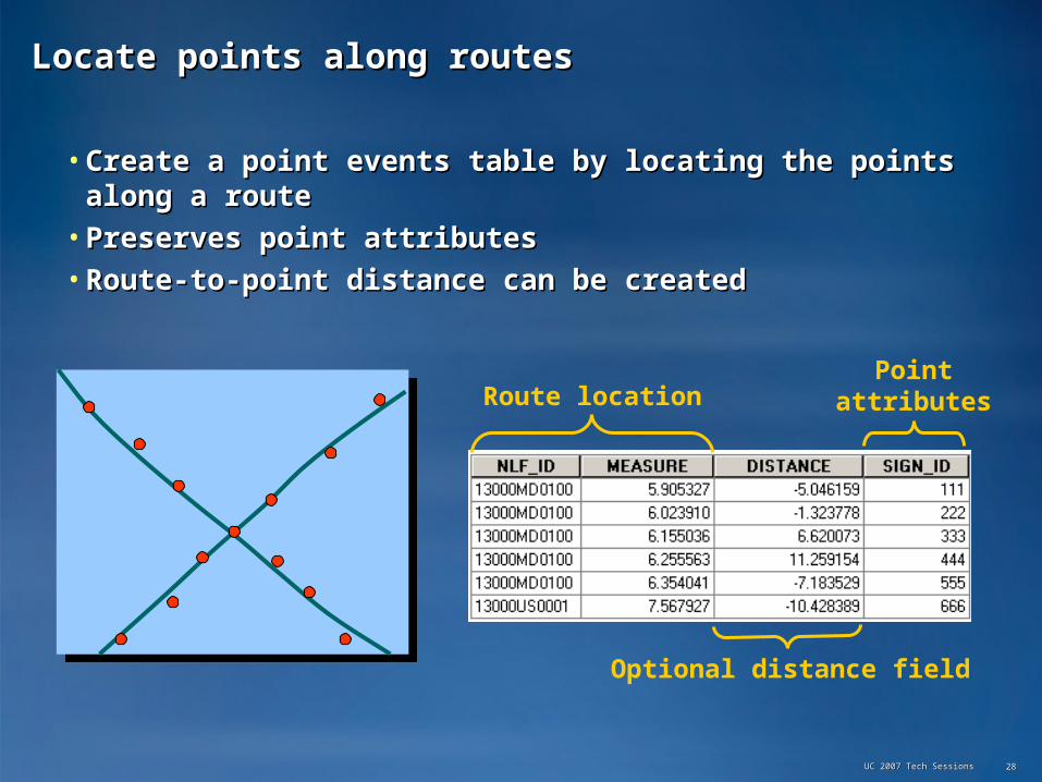
Locate points along routesLocate points along routes
• Create a point events table by locating the points Create a point events table by locating the points along a routealong a route
• Preserves point attributesPreserves point attributes• Route-to-point distance can be createdRoute-to-point distance can be created
UC 2007 Tech SessionsUC 2007 Tech Sessions 2828
Route locationPoint
attributes
Optional distance field

Locate polygons along routesLocate polygons along routes
• Creates a line events table from the intersection of routes with Creates a line events table from the intersection of routes with polygonspolygons
• Preserves polygon attributesPreserves polygon attributes
UC 2007 Tech SessionsUC 2007 Tech Sessions 2929
Route location Polygon attributes

Find & identify route locationsFind & identify route locationsRoute event analysisRoute event analysis
UC 2007 Tech SessionsUC 2007 Tech Sessions 3030
Demo 2Demo 2

OutlineOutline
• Fundamental conceptsFundamental concepts• Terminology in ArcGISTerminology in ArcGIS• Query & analysis operationsQuery & analysis operations• Creating & maintaining routesCreating & maintaining routes
– Creating routesCreating routes
– Calibrating routesCalibrating routes
– Editing routesEditing routes
• SummarySummary
UC 2007 Tech SessionsUC 2007 Tech Sessions 3131

Creating routesCreating routes
• Routes are created byRoutes are created by– Merging linear features based on common identifiersMerging linear features based on common identifiers
• E.g., route IDE.g., route ID
– Setting measures based on one or two fields Setting measures based on one or two fields
• Create routesCreate routes– By creating a new empty feature class & loading dataBy creating a new empty feature class & loading data
– By creating a new route feature class from existing line featuresBy creating a new route feature class from existing line features
– By converting an existing route feature classBy converting an existing route feature class
• MethodsMethods– ArcToolbox (ArcToolbox (CreateRoutesCreateRoutes & & CalibrateRoutesCalibrateRoutes GP tools) GP tools)
– ArcCatalogArcCatalog
– ArcMapArcMap
UC 2007 Tech SessionsUC 2007 Tech Sessions 3232

Create a Route Feature Class from ScratchCreate a Route Feature Class from Scratch
• Follow standard procedures for creating a feature classFollow standard procedures for creating a feature class
UC 2007 Tech SessionsUC 2007 Tech Sessions 3333
Enable M storageEnable M storage
Set geometry typeSet geometry type
Define route identifier field
Define route identifier field

Create a route feature class from existing linesCreate a route feature class from existing lines
UC 2007 Tech SessionsUC 2007 Tech Sessions 3434
• CreateRoutes GP toolCreateRoutes GP tool
Input featuresInput features
Route ID fieldRoute ID field
Output featuresOutput features
Measure field(s) or Geometric Length
Measure field(s) or Geometric Length

Calibrate route feature classCalibrate route feature class
• Setting a route’s measurement systemSetting a route’s measurement system
UC 2007 Tech SessionsUC 2007 Tech Sessions 3535
CalibrateCalibrate
10
0.0
55.6510
1525
30Points with measures
Points with measures
Existing vertexExisting vertex
28.4
35.25
1015
20 2530
1.1
New vertices createdwith interpolated
measures
New vertices createdwith interpolated
measuresExisting vertex’s
measure is interpolated
Existing vertex’s
measure is interpolated
ExtrapolationExtrapolation
ExtrapolationExtrapolation
AA

Editing routesEditing routes
UC 2007 Tech SessionsUC 2007 Tech Sessions 3636
Sketch PropertiesSketch Properties
Tasks for linear referencingTasks for linear referencing
Route Editing toolbarRoute Editing toolbarRoute Editing toolbarRoute Editing toolbar
Define line portion
Define line portion
Make RouteMake Route
Calibrate Route
Calibrate Route
• Edit routes just like any polylineEdit routes just like any polyline– Extend, delete, split, etcExtend, delete, split, etc Editing toolbarEditing toolbarEditing toolbarEditing toolbar
AA

Create a route feature class,Create a route feature class,then calibrate its M valuesthen calibrate its M values
UC 2007 Tech SessionsUC 2007 Tech Sessions 3737
Demo 3Demo 3

SummarySummary
• Fundamental conceptsFundamental concepts– Defined linear referencing and its applicationsDefined linear referencing and its applications
• Terminology in ArcGISTerminology in ArcGIS– Routes, measures, events, & dynamic segmentationRoutes, measures, events, & dynamic segmentation
• Query & analysis operationsQuery & analysis operations– Simple querying, symbology, & analysis toolsSimple querying, symbology, & analysis tools
• Creating & maintaining routesCreating & maintaining routes– How to create, calibration, & editingHow to create, calibration, & editing
• Please complete review surveysPlease complete review surveys
UC 2007 Tech SessionsUC 2007 Tech Sessions 3838

Questions?Questions?
UC 2007 Tech SessionsUC 2007 Tech Sessions 3939