literature synthesis of the effects of forest …...2017/02/02 · glacial deep-seated landslides...
TRANSCRIPT

Literature Synthesis of the Effects of Forest Practices on Glacial Deep-Seated Landslides and Groundwater Recharge
Prepared for the Upslope Processes Scientific Advisory Group Cooperative Monitoring, Evaluation, and Research Committee
Technical Advisory Team
Thomas Badger, Washington Department of Transportation Lee Benda, TerrainWorks Wendy Gerstel, Qwg Applied Geology Dan McShane, Stratum Group Linton Wildrick, Pacific Groundwater Group
Project Management
Charlene Andrade, DNR Lynne Rodgers Miller, M2 Environmental Services
by Daniel Miller M2 Environmental Services Seattle, Washington [email protected]
Personal Services Contract PSC 16-206
M2 Environmental Services June 8, 2016
The Project The background and context for this project were provided by the Upslope Processes Scientific Advisory Group (UPSAG) in the introduction to the Request for Qualifications:
In response to recent deep-seated landslide events, the Forest Practices Board (Board) requested the Timber Fish and Wildlife Policy Committee (Policy) to develop recommendations related to the regulation of forest practices activities on deep-seated landslides in glacial deposits and their associated groundwater recharge areas. Per the Board’s request, Policy directed the Upslope Processes Scientific Advisory Group (UPSAG) and CMER to develop and execute a scope of work for a focused literature review and synthesis to update CMER on research assessing the effect of forest practices on groundwater recharge areas and deep-seated landslides in glacial materials. The review and synthesis will provide a baseline for UPSAG to further develop an unstable slopes research strategy for inclusion in the 2017 CMER Work Plan. The research strategy developed by UPSAG/CMER will be brought to Policy for approval.
CMER carried out a literature review of forest practices effects on deep-seated landslides in 1991 that resulted in the 1992 Timber Fish Wildlife publication TFW-SH5-91-001 by Thomas Koler, “Literature Search of Effects of Timber Harvest to Deep-seated Landslides.” That report identified several case studies where forest practices occurred on deep-seated landslides, but the author noted the general lack of studies cited in glacial materials typical of many deep-seated landslides in Washington State. This project will review literature that has been authored since the 1992 Koler report. This project will produce an updated review of the literature in this field, including a brief summary of each pertinent study found and its findings relevant to the groundwater recharge areas or deep-seated landslides in glacial materials, and will produce a synthesis that summarize the overall findings and provide initial recommendations for future research projects.
Enclosures The attached literature review comprises three separate sections:
1. A synthesis document describing- the current state of our understanding of the key issues in addressing glacial deep-seatedlandslides, with reference to the research adding to our understanding,- answers to eight key questions posed by UPSAG, and- identifying gaps in knowledge that the adaptive management program could consideraddressing and suggesting further directions that CMER might take in tacking thischallenging issue.
2. Individual detailed annotations for seventeen key articles, describing the specificapproaches of interest placing them in the context of other articles in the field
3. A spreadsheet briefly summarizing the content of 142 articles.Under separate cover is
4. GIS coverage for a selected database of geotechnical studies.

June 8, 2016
M2 Environmental Services
Project Summary
This document provides a synthesis of information found in published literature that can inform our understanding of glacial deep-seated landslides: in particular, of how forest practices can affect these landslides and how we can better assess landslide sensitivity to forest practices. Few studies specifically examine effects of forest practices on landslides, but many studies examine issues important for understanding and anticipating these effects. The study of landslides entails topics that span a range of temporal and spatial scales: from the mechanics of grain-to-grain contacts in deforming soils, to the effects of transpiring vegetation on annual water budgets, to the depositional and stress history of the glacial deposits where these landslides occur. All these topics contribute to our ability to anticipate landslide behavior and sensitivity to forest practices, and all were included in this survey of current literature.
To identify references to include in this survey, we started by searching bibliographies assembled from the 1) Unstable Slopes Board Manual, Section 161, 2) the UPSAG scoping done for groundwater recharge to glacial deep-seated landslides in 2007, 3) references suggested by the advisory team and provided by other workers in the field (in particular, Dave Parks at DNR provided an extensive bibliography on this topic), 4) geotechnical reports provided by UPSAG, 5) references in M2 Environmental’s current EndNote data base, 6) keyword searches of GoogleScholar and ResearchGate, and 7) resources discovered during the course of this review.
Lack of studies specifically focused on sensitivity of glacial deep-seated landslides to forest practices rapidly revealed that a broader look over available literature was necessary. To this end, diverse papers cited in the reviewed studies provided a rich source of additional material, so a large proportion of the papers reviewed suppliment those in the bibliographies listed above. Our current database contains nearly 600 citations that directly address issues pertinent to this review. We have distilled these to the 142 most informative and include these in an Excel spreadsheet providing details on each.
The scientific advisory team assembled for this project aided in identifying potential resources for review, and helped guide presentation of material for this synthesis.
We have also provided detailed summaries for a subset of these published studies. These provide context showing how these and related studies are important for understanding the sensitivity of glacial deep-seated landslides to forest practices.
This document will assist UPSAG and CMER in prioritizing studies to assess the potential effects of forest practices on Glacial Deep-Seated Landslides and Groundwater Recharge.
We present information in a sequential manner, so that each topic contributes to the next. Section headings are used generously, so the table of contents provides a detailed roadmap of topics presented. The take-home points from this review:
The current standard of geotechnical practice as applied in the forest-practices arena doesnot include feasible methods for consistent and objective determination of sensitivity of
1 From the 11/2015 version.

June 8, 2016
M2 Environmental Services
glacial deep-seated landslides to forest practices, or for assessing hazards posed by these landslides. (This is the motivation for this literature review).
The processes affecting soil water balance and groundwater recharge are wellcharacterized, so that effects of timber harvest on groundwater recharge can be estimatedwithin a certain range. Although a number of studies provide direct measurements ofwater-budget components (evapotranspiration, throughfall), few studies examine effectsof forest practices directly, so these effects must be inferred using measurements fordifferent land-cover types.
Geotechnical properties of glacial deposits are well characterized, in terms of the range ofproperties encountered. These deposits include two primary types of materials: coarse-grained outwash deposits, and fine-grained till and lake deposits. These two types havevastly different flow rates for groundwater and react differently to shear stresses.Occurrences and activation of glacial deep-seated landslides are governed primarily bythe location of fine-grained deposits and the potential for saturation of these deposits.
The fine-grained soils composing till and glacial lake (lacustrine) deposits exhibitresidual strength after failure that is less than their peak strength prior to failure.Landslide deposits may therefore respond to perturbations less than required for initialfailure. These soils also tend to dilate (increase in volume) and become effectivelystronger as they deform, so that motion of the failed mass of material tends to beintermittent. This is a transient effect, allowing many glacial deep-seated landslides topersist with periodic movements for hundreds, perhaps thousands, of years.
These landslides can also, under certain poorly understood conditions, failcatastrophically, creating a rapidly moving, extremely mobile deposit that can flowconsiderable distance.
Pore pressures reduce effective soil shear strength. Landslide motion is thereforecommonly initiated by increasing pore pressures. Pore pressures at depths affecting deep-seated landslides exhibit complex responses to precipitation, integrating effects overseveral time scales. Depending on soil depths, soil properties, and characteristics of therecharge area, pore pressures at depth may respond gradually to patterns of precipitationthat span several years. Additionally, preferential flow paths into deposits, such astension cracks, can cause rapid response to precipitation events. Pore pressures reflect thecombination of these different processes.
Sensitivity of glacial deep-seated landslides to forest practices is poorly understood. Datato characterize this sensitivity has not been systematically collected, and models toanticipate response of landslides to forest practices have been hindered by the need fordetailed information on site stratigraphy and material properties. However, advances intechniques for assessing model sensitivity to poorly constrained parameters, availabilityof high-resolution LiDAR elevation data, and much more powerful computers offer newopportunities for identifying landslide hazards and assessing landslide sensitivity.

June 8, 2016
M2 Environmental Services
1 Table of Contents
1 Introduction _____________________________________________________________________________ 1
2 Sources _________________________________________________________________________________ 1
3 Glacial Deep‐Seated Landslides and Washington’s Forest Practice Rules ____________________________ 3
4 Landslide hazard and risk __________________________________________________________________ 4
5 Why landslides occur ______________________________________________________________________ 5
5.1 Regional history. _____________________________________________________________________ 5
5.2 Local history. ________________________________________________________________________ 6
6 Shallow versus deep‐seated landslides _______________________________________________________ 6
7 Conceptual Background ___________________________________________________________________ 7
7.1 Glacial stratigraphy promotes development of saturated zones in slopes. ________________________ 7
7.2 Pore pressure in saturated zones reduces soil shear strength. _________________________________ 7
7.3 Pore pressure is proportional to depth of saturation. ________________________________________ 7
7.4 Depth of saturation may increase with recharge. ___________________________________________ 8
7.5 Saturation depth may depend on spatially distant recharge. __________________________________ 8
7.6 Groundwater flow paths may not match surface‐water flow paths. ____________________________ 8
7.7 Water table responses can lag precipitation inputs. _________________________________________ 9
7.8 Pressure‐fluctuation lag times, duration, and magnitude vary with depth. _______________________ 9
7.9 Deep‐seated landslide movement is influenced by pore pressure. _____________________________ 10
7.10 Preferential flow paths can produce rapid pore‐pressure response. ____________________________ 10
7.11 Recharge equals precipitation minus runoff and evapotranspiration. __________________________ 10
7.12 The substrate controls recharge rate. ___________________________________________________ 12
7.13 Overconsolidated glacial lacustrine deposits exhibit brittle behavior. __________________________ 12
7.14 Disturbed clay‐rich soils exhibit residual strength. __________________________________________ 13
7.15 Soils dilate or compress when deformed in shear. __________________________________________ 13
8 Glacial deep‐seated landslide causes and triggers _____________________________________________ 14
8.2 Surface topography. _________________________________________________________________ 14
8.3 Changes in topography. ______________________________________________________________ 14
8.4 Increased pore pressure. ______________________________________________________________ 15
8.5 Precipitation. _______________________________________________________________________ 15
8.6 Loss of evapotranspiration. ___________________________________________________________ 16
8.7 Response may lag the trigger. _________________________________________________________ 17
8.8 Progressive failure. __________________________________________________________________ 17
8.9 Surface Loading ____________________________________________________________________ 18
8.10 Earthquakes _______________________________________________________________________ 18

June 8, 2016
M2 Environmental Services
9 Landslide behavior_______________________________________________________________________ 18
9.1 Creep as a precursor to slope failure. ____________________________________________________ 18
9.2 Intermittent movement. ______________________________________________________________ 18
9.3 Catastrophic failure. _________________________________________________________________ 19
9.4 Climate‐driven variations in activity. ____________________________________________________ 21
10 Identification of existing landslides _________________________________________________________ 21
11 Runout ________________________________________________________________________________ 21
11.1 Geomorphic assessment ______________________________________________________________ 22
11.2 Geometric methods. _________________________________________________________________ 22
11.3 Analytical methods __________________________________________________________________ 23
12 Answers to questions posed by UPSAG ______________________________________________________ 23
12.1 What are the impacts of forest‐practice activity on glacial deep‐seated landslide movement? ______ 23
12.2 What are the impacts to groundwater recharge from forest practice activity? ___________________ 24
12.3 How do the properties of glacial material affect glacial deep‐seated landslide movement? _________ 25
12.4 What methodologies are used to delineate groundwater recharge areas? ______________________ 26
12.5 What are triggers of glacial deep‐seated landslides? _______________________________________ 27
12.6 Does harvesting of the recharge area of a glacial deep‐seated landslide promote its instability? _____ 28
12.7 Can relative levels of response to forest practices be predicted by key characteristics of glacial deep‐
seated landslides and/or their groundwater recharge areas? ________________________________________ 29
12.8 How do answers to the above questions guide on‐the‐ground identification, delineation, and
interpretation of glacial deep seated landslide features and response to forest practices? _________________ 32
13 Knowledge / data gaps ___________________________________________________________________ 33
13.1 We lack information on the range of depositional and erosional histories, the resulting geomorphic
settings, and the styles, histories, and controls on movement of characteristic deep‐seated landslide types in
Washington. ______________________________________________________________________________ 33
13.2 Spatial and temporal scales of groundwater flow patterns and responses to precipitation and timber
harvesting in settings characteristic of glacial deep‐seated landslides are poorly constrained. ______________ 33
13.3 Spatial and temporal patterns of landslide responses to precipitation and land use are poorly
characterized. _____________________________________________________________________________ 34
13.4 We have no commonly available analysis tools for applying available data to assess landslide stability
or sensitivity to forest practices. _______________________________________________________________ 34
14 Recommendations / possibilities ___________________________________________________________ 34
14.1 Build a definitive landslide inventory for glacial deep‐seated landslides. ________________________ 34
14.2 Create a basic set of GIS‐based tools for using currently available data to assess landslide stability and
sensitivity to forest practices. _________________________________________________________________ 34
14.3 Create a classification of characteristic geomorphic settings and morphological types for glacial deep‐
seated landslides and map these across the state. ________________________________________________ 35
14.4 Define characteristic surface profiles. ___________________________________________________ 35
June 8, 2016
M2 Environmental Services
14.5 Use groundwater models to explore the spatial and temporal scales of groundwater responses to
spatially and temporally variable recharge. ______________________________________________________ 35
14.6 Evaluate potential for using Synthetic Aperture Radar (SAR) analyses for detecting active landslides
over regional extents _______________________________________________________________________ 35
14.7 Apply soil‐water‐balance models to explore recharge rates __________________________________ 36
14.8 Collect monitoring data for a selection of characteristic sites _________________________________ 36
15 Appendix. Water budget __________________________________________________________________ 37
15.1 Evapotranspiration __________________________________________________________________ 38
15.2 Interception ________________________________________________________________________ 39
15.3 Recharge __________________________________________________________________________ 41
16 Glossary _______________________________________________________________________________ 43
17 References _____________________________________________________________________________ 46
Attachment One: Annotations of Key Papers Attachment Two: Database

June 8, 2016
1 M2 Environmental Services
1 Introduction
Landslides are gravity-driven movements of soil (and rock and vegetation, depending on the circumstances) that occur rapidly enough, and with sufficient impact, that they get our attention. More gradual, diffuse movements, which may go unnoticed, are termed creep. Geologists refer to all processes of gravity-driven movement as mass wasting. Among the large variety of landslide types geologists identify, our focus in this synthesis is on glacial deep-seated landslides.
Glacial deep-seated landslides receive special attention in Washington’s Forest-Practice Rules. These landslides and the groundwater recharge areas linked to them are included as “Rule-Identified Landforms”2 and receive special scrutiny prior to approval of forest practice applications expressly due to their potential sensitivity. However, few guidelines exist to aid practitioners in determining if a landslide is sensitive to forest practices or for assessing the potential hazards posed by such landslides.
This synthesis reports on a review of literature to determine what is known about glacial deep-seated landslides, how they respond to forest practices, and what steps might be taken to better anticipate landslide behavior. We first present background information essential to develop a conceptual understanding of glacial deep-seated landslide processes, we then address specific questions posed by UPSAG, and then move into identifying knowledge and data gaps that hinder our ability to assess sensitivity to forest practices, and close with recommendations for addressing these gaps. An appendix provides additional information on effects of forest harvest on soil water budgets.
2 Sources
In this review of the literature, we found only one published study that explicitly examined sensitivity of a glacial deep-seated landslide to forest practices. This was Miller and Sias (1998), which described use of computer models for assessing this sensitivity, without empirical validation of model results3. Given the paucity of directly applicable studies, we needed to expand our scope. So we extended our search to encompass different aspects of the knowledge base needed to assess landslide sensitivity to forest practices. We identified seven broad categories of inquiry (listed below), and sought studies relevant to glacial deep-seated landslides from each. To identify papers to review, we started with the bibliographies compiled from previous studies that was provided by UPSAG, suggestions from the science advisory team assembled for this project, preliminary keyword searches using Google Scholar and ResearchGate, and our own bibliographic database. However, an important additional source
2 WAC 222-15-050(1)(d)(i) (http://apps.leg.wa.gov/wac/default.aspx?cite=222-16-050) identifies five sets of potentially unstable slopes or landforms that require special attention prior to approval of forest practices. These landforms were first referred to as “rule-identified landforms” in the Mass Wasting Effectiveness Monitoring Project (Stewart et al., 2013) and are described in Section 16 of the Forest Practices Board Manual (http://file.dnr.wa.gov/publications/fp_board_manual_section16.pdf) 3 Full disclosure, I (Dan Miller) am first author of that paper.

June 8, 2016
2 M2 Environmental Services
became citations within the papers reviewed, so the universe of potential resources continued to expand throughout the course of this project.
Here are the categories of inquiry, with subdivisions, and the number of citations included in this review applicable to each.
1. Water Balance (Evapotranspiration, throughfall, interception, transpiration, runoff, recharge): 26
a. Directly apply to timber-harvest effects: 2 b. Indirectly apply: 24 c. Direct measurement of evapotranspiration: 2 d. Direct measurement of throughfall: 8 e. Use of water-balance models to estimate recharge: 11
2. Saturated / Unsaturated groundwater flow (groundwater response to precipitation): 19 a. Directly apply to glacial deep-seated landslides: 7 b. Indirectly apply 12 c. Direct measurements: 12 d. Modeling: 9
3. Geotechnical Studies / Reviews: 20 a. Directly apply to glacial deep-seated landslides: 6 b. Indirectly apply: 14
4. Landslide Case Studies (including inventories, reviews) 46 a. Glacial deep-seated 8 b. Bedrock 34 c. Inventories 4
5. Models (Stability models, Coupled models, GIS): 18 a. Coupled hydrologic 3 b. Coupled groundwater/hydrologic/stability 1 c. Coupled hydro/stability 3 d. Coupled groundwater/stability 1 e. Stability 7 f. Water balance 5
6. Landslide mapping (remote sensing, geophysical) 23 a. LiDAR 9 b. Synthetic Aperture Radar (SAR) 6 c. Geophysical techniques 4 d. Object oriented 4
7. Runout 6 a. Directly applicable for forest-practice assessment 3 b. Indirectly 3

June 8, 2016
3 M2 Environmental Services
There are 142 citations included in the database for this review, although we examined considerably more than this: our EndNote database currently contains over 600 citations relevant to these seven categories. Many of these are excluded because they focus primarily on processes associated with shallow landsliding or because they are redundant with references already included.
3 Glacial Deep-Seated Landslides and Washington’s Forest Practice Rules
Washington’s Forest Practice Rules include provisions to minimize forest-practice-related increases in landslide rates. These provisions are defined in the Washington Administrative Code (WAC), Section 222-16-050(1), which states that proposed activities involving “Timber harvest, or construction of roads, landings, gravel pits, rock quarries, or spoil disposal areas, on potentially unstable slopes or landforms described in (d)(i) of this subsection that has the potential to deliver sediment or debris to a public resource or that has the potential to threaten public safety” are “Class IV-special” forest practices. Class IV-special forest practices require an environmental checklist in compliance with the State Environmental Policy Act (SEPA).
SEPA policies for potentially unstable slopes and landforms are defined in WAC 222-10-030. These policies require certain analyses of potentially unstable slopes and landforms prior to approval of Class IV-special forest practices. These analyses must be performed by a qualified expert4 and evaluated by Department of Natural Resources staff. The analysis must address the following three issues:
a) The likelihood that the proposed forest practices will cause movement on the potentially unstable slopes or landforms, or contribute to further movement of a potentially unstable slope or landform;
b) The likelihood of delivery of sediment or debris to any public resources, or in a manner that would threaten public safety; and
c) Any possible mitigation for the identified hazards and risks.
The DNR’s evaluation must then determine if the proposed forest practices:
a) Are likely to increase the probability of a mass movement on or near the site; b) Would deliver sediment or debris to a public resource or would deliver sediment or debris
in a manner that would threaten public safety; and c) Such movement and delivery are likely to cause significant adverse impacts.
If it is determined that the proposed forest practice is likely to have a probable significant adverse impact, then SEPA requires that “Specific mitigation measures or conditions must be designed to avoid accelerating rates and magnitudes of mass wasting that could deliver sediment or debris to a public resource or could deliver sediment or debris in a manner that would threaten public safety”.
4 A qualified expert means a person licensed under chapter 18.220 of the Revised Code of Washington as either an engineering geologist or as a hydrogeologist

June 8, 2016
4 M2 Environmental Services
WAC 222-16-050, subsection (1)(d)(i), identifies five sets of potentially unstable slope and landform types:
A. Inner gorges, convergent headwalls, or bedrock hollows with slopes steeper than thirty-five degrees (seventy percent);
B. Toes of deep-seated landslides, with slopes steeper than thirty-three degrees (sixty-five percent);
C. Groundwater recharge areas for glacial deep-seated landslides; D. Outer edges of meander bends along valley walls or high terraces of an unconfined
meandering stream; or E. Any areas containing features indicating the presence of potential slope instability which
cumulatively indicate the presence of unstable slopes.
Types B, D, and E may all potentially involve glacial deep-seated-landslide features, and type C explicitly identifies the groundwater recharge area to a glacial-deep-seated landslide as a feature of concern.
Section 16 of the Forest Practices Board Manual, “Guidelines for Evaluating Potentially Unstable Slopes and Landforms” 5, provides descriptions of different landslide types, criteria for identifying unstable slopes and landforms (including groundwater recharge areas for glacial deep-seated landslides), and suggestions for analysis methods to assess the likelihood that proposed forest practices will affect landslide movement.
However, there is little guidance in the board manual for quantitative assessment of likelihood or for determining how forest practices within the groundwater recharge area of a glacial deep-seated landslide are likely to influence landslide activity. This lack is not the fault of the board, but reflects the current standard of practice for landslide hazard assessments. This literature review and synthesis are intended to guide efforts to improve the standard of practice.
4 Landslide hazard and risk
Landslides span a vast range of sizes, from cubic meters to cubic kilometers of material, and subsequently exert a vast range of effects on landscapes and their inhabitants. Landslides affect valley shape, stream morphology, and sediment supply, and therefore impact basin hydrology, basin ecology, and basin productivity. Perturbations to any aspect of these interactive processes, such as changes in the frequency or magnitude of landslides, can generate a cascade of consequences potentially detrimental to resources we value, such as aquatic habitat and sustainable fish populations. Forest-practice rules are intended to limit the frequency and magnitude of management-associated landslide events.
The resources we value include public infrastructure, private property, and human lives. The SR530 landslide clearly demonstrated the consequences of unrecognized landslide hazards, and highlighted the need for systematic hazard mapping (Lombardo et al., 2014).
5 http://file.dnr.wa.gov/publications/fp_board_manual_section16.pdf

June 8, 2016
5 M2 Environmental Services
For decision makers, it is important to understand the hazards posed by landslides and to distinguish between hazard and risk. To assess hazard requires determination of the probability that a landslide will occur and the consequences of occurrence. These consequences depend on multiple landslide characteristics:
Location. Size (area, volume). Materials involved (mud, boulders, large trees). Rate of movement. Downslope extent of runout.
To assess risk requires determination of the costs entailed by landslide occurrence. These costs include direct financial losses of destroyed property and infrastructure, loss of human lives, the loss of natural resources such as timber and fish habitat, and the cumulative effects of changing landslide rates on the geomorphic processes that maintain healthy ecosystems. “Hazard” encompasses the probability and consequences of landslide occurrence; “risk” incorporates the costs.
To assess hazard, forest-practice rules therefore require assessment of “the likelihood that the proposed forest practices will cause movement on the potentially unstable slopes or landforms, or contribute to further movement of a potentially unstable slope or landform” and “the likelihood of delivery of sediment or debris to any public resources, or in a manner that would threaten public safety”. To assess risk, SEPA requires determination of likelihood for “significant adverse impact”. These are ambiguous statements, with no quantification of “likelihood” or “significant”. This ambiguity hinders consistent and effective application of forest-practice rules.
Such ambiguity is a consequence of the current lack of methods and tools for quantifying the likelihood that a proposed forest practice will cause or contribute to movement of an unstable slope or landform, and for quantifying impacts of landsliding. A variety of groups are developing specific guidelines for quantitative hazard and risk assessment; Corominas et al. (2014) provide a detailed review. A first step in any assessment is determination of the potential landslide characteristics listed above: location, size, materials, rate of movement, and extent of runout. Additionally, we must determine sensitivity of potential landslides to proposed forest practices.
5 Why landslides occur
5.1 Regional history.
Past and ongoing tectonism, glaciation6, seismicity, climate, and erosion interact to create stratigraphy, material properties, and topography that contribute to the formation of certain types of landslides in certain locations. Recognition of the history and the processes involved can aid 6 For a nice animation of the last (Vashon) advance of the ice sheet into Puget Sound, see https://www.youtube.com/watch?v=YHWMHzi_deg
June 8, 2016
6 M2 Environmental Services
in anticipating where landslides may be found and how they behave. For example, Thorsen (1989) provides an overview of landslide provinces in Washington state. Morgan et al. (2012) provide an example of how detailed geologic mapping, careful field observations, and geomorphic interpretations can be integrated to infer the history that created conditions conducive for landsliding in the Peace River valley of eastern British Columbia.
5.2 Local history.
Details of depositional events, history of sediment compression (e.g., by ice), channel incision, and river migration, potentially down to the scale of individual headwater basins, determine if glacial deep-seated landslides exist, and if so, whether they are poised for reactivation or simply stable relicts of past conditions. Examination of regional and local geology and geomorphology can aid in assessing landslide hazards and identifying the factors that may lead to an increase in landslide hazards; see, for example, Dieu and Butt (2004), who incorporated field and photo observations into geomorphic interpretation for a stability assessment that evaluated hazards posed by timber harvest.
6 Shallow versus deep-seated landslides
Landslides are broadly divided into two types: shallow and deep seated. Shallow landslides involve movement of material to about 2 or 3 meters depth, within the rooting zone of trees; deep-seated landslides extend below the rooting zone. This is a useful distinction, because the triggering processes and landscape effects of shallow and deep-seated landslides can differ markedly.
At shallow depths, infiltrating water can create wetting fronts and rapid changes in pore pressures, so that shallow landslides are triggered during intense or cumulative rainfall events that saturate shallow soils. Deep-seated landslides may respond to the integrated effect of storm sequences spanning years. (Pore-pressure responses to infiltration evolve more slowly with depth and are discussed in more detail in a later section). The effects of the frequency distribution of storm magnitudes may therefore differ for shallow and deep-seated landslides.
Shallow and deep-seated landslides also have different landscape legacies. Shallow landslides often disintegrate upon failure and add to colluvial fan deposits. Their topographic signature is subtle and the scars revegetate quickly. Deep-seated landslides may move incrementally, evolve into earthflows, or fail catastrophically to create distinctive, hummocky deposits downslope. They create distinct landscape features on slopes that can persist for millennia.
Upon first occurrence, deep-seated landsliding alters the properties of the materials involved, so that the body of the landslide – that mass of material that has moved downslope – may be susceptible to further movement under conditions that differ from those that triggered initial formation of the landslide. These changes in material properties can also make deep-seated landslides susceptible to catastrophic failure, even after centuries of apparent stability or a long history of intermittent movement (Fletcher et al., 2002).
The focus of this synthesis is on deep-seated landslides, and in particular, on deep-seated landslides in deposits formed in association with glacial processes. The stratigraphy and material

June 8, 2016
7 M2 Environmental Services
properties of some of these deposits render them particularly susceptible to deep-seated landsliding and potentially sensitive to forest practices.
7 Conceptual Background
Knowledge of the hydrogeologic processes and material properties involved in glacial deep-seated landsliding is a prerequisite for understanding the potential influence that forest practices have and for anticipating the hazards they pose.
7.1 Glacial stratigraphy promotes development of saturated zones in slopes.
Washington’s glacial history, involving sediment-laden outwash streams and ice-dammed lakes, has created stratigraphy that juxtaposes 1) more highly permeable, coarse-grained materials (medium-to-coarse sand, gravel, cobbles, and boulders) deposited by melt-water streams with 2) much lower-permeability, fine-grained materials (fine sand, silt, and clay) deposited in quiet water (lacustrine deposits) or at the base of moving ice sheets (lodgement till). The coarse-grained materials have much greater hydraulic conductivity than the fine-grained materials (Savage et al., 2000b). When water infiltrating downward through coarse-grained materials encounters fine-grained layers with much lower infiltration capacity (an aquitard), it pools above the fine-grained layers, creating zones of saturation. A common example is where coarse-grained, permeable outwash deposits overlie fine-grained, glacial lacustrine deposits. For descriptive illustrations, see Tubbs (1974), Gerstel et al. (1997), and Shipman (2001).
This pooled water creates an unconfined aquifer within the coarse-grained deposits. Water within this aquifer flows to seeps where contacts between these coarse- and fine-grained layers intersect the ground surface, establishing a pattern of lateral groundwater flow.
The saturated zone of pooled water provides a persistent – and permanent in many locations – source of water that infiltrates into the fine-grained sediments below, thus also maintaining a saturated zone within the fine sediments. It is in these fine-grained materials that water plays a primary role in deep-seated landslide development and behavior.
7.2 Pore pressure in saturated zones reduces soil shear strength.
Saturation of pore spaces reduces effective stress (the load supported by particle contacts), which in turn reduces soil shear strength. The reduction of effective stress and corresponding soil shear strength is proportional to water pressure (pressure head) within the pore spaces7.
7.3 Pore pressure is proportional to depth of saturation.
For zones of saturation in an unconfined aquifer, pore pressures are proportional to the overlying height of the water column.8
7 Concepts of effective stress and soil shear strength are described in every text book on soil mechanics. A thorough description is provided in Article 15 of Terzaghi et al. (1996). 8 Concepts of hydraulic head, pore pressure, and effective stress are discussed in any text on groundwater flow: section 2.9 in Freeze and Cheery (1979), for example. Though beyond the scope of this document, it is important to

June 8, 2016
8 M2 Environmental Services
7.4 Depth of saturation may increase with recharge.
Water percolating from above adds to the saturated zone and recharges groundwater. If inflow (from above and from lateral groundwater flow) exceeds outflow (from lateral groundwater flow and infiltration into the lower-conductivity layer below) saturation depth and associated pore pressures increase.
7.5 Saturation depth may depend on spatially distant recharge.
At seepage faces, groundwater flows out onto the ground surface, removing water from the saturated zone, thus reducing saturation depth. Water in the saturated zone flows from areas of higher head towards areas of lower head; that is, from areas where the water-table elevation is higher to areas where the water-table elevation is lower. Thus, spatial and temporal variation in groundwater recharge, together with the subsurface distribution of low- and high-conductivity soils and the topographic location of seepage faces, act to create a water-table topography that determines pore pressures at depth and drives groundwater flow, both laterally and into the underlying lower-conductivity materials. Water-table elevation or more properly, hydraulic head value, at a given point thus depends on recharge from above at that point and on groundwater flowing to that point from areas with higher head. The total area contributing recharge to groundwater flowing to that point is the groundwater recharge area for that location.
This description applies for unconfined aquifers, but the same principles apply for flow into, through, and out of confined aquifers. Spatial variations in hydraulic head drive groundwater flow.
7.6 Groundwater flow paths may not match surface-water flow paths.
Gravity drives the flow of groundwater from areas where recharge occurs via infiltration into the ground to areas where discharge occurs out of the ground at seepage faces and stream channels. The water-table surface therefore slopes from areas of recharge towards areas of discharge. Discharge occurs at topographic low points (e.g., at stream channels), so the water-table surface generally tends to follow surface topography. However, issues exist that complicate this simple model of local topography reflecting groundwater flow.
Subsurface flow occurs in three dimensions. Flow at depth can bypass small streams, so groundwater may originate outside the local basin (Tóth, 1963). Welch and Allen (2012) illustrate the consequences for real topography using a 3-dimensional model of groundwater flow, showing how recharge areas can extend beyond low-order basins and how they expand and contract in response to changing recharge rates.
Groundwater flow is affected by the three-dimensional distribution of subsurface features. For example, the water-table slopes to the location of seeps, which may be controlled by midslope contacts between high- and low-conductivity layers, not low points in the
note that groundwater flow induces seepage forces in hillslopes that affect stability (Iverson and Reid, 1992; Reid and Iverson, 1992).

June 8, 2016
9 M2 Environmental Services
topography; and lenses of silt in sandy outwash deposits can create local zones of perched groundwater.
Water-table topography is affected by the spatial and temporal distribution of recharge. Water tables tend to rise under areas of higher recharge and to fall under areas of lower recharge. Localized zones of high infiltration, such as drainage of runoff into permeable substrates, can produce a mound in the water table.
Groundwater flow also occurs in deeper, confined aquifers. Upward seepage from these aquifers can affect pore-pressures in overlying materials.
7.7 Water table responses can lag precipitation inputs.
Water infiltrating the soil to recharge groundwater must first traverse a zone of unsaturated soil. Flux through the unsaturated soil depends on soil texture, soil moisture content, and on the thickness of the unsaturated zone. The timing and magnitude of groundwater recharge for precipitation events thus depends on the depth, texture, and distribution of moisture content of the unsaturated zone. Evaporation from the ground surface and transpiration of water extracted by plant roots reduces soil moisture in this zone, which reduces the amount of water available to percolate to groundwater and increases the traversal time. Thus, the water-table (and pore-pressure) response to precipitation events depends on antecedent moisture content of the unsaturated zone and varies seasonally (Bogaard, 2001).
7.8 Pressure-fluctuation lag times, duration, and magnitude vary with depth.
A rainstorm generates, if large enough, a pulse of infiltrating water that, after traversing the unsaturated zone, provides a pulse of recharge to groundwater with an associated rise of the water table. This generates a pore-pressure wave that propagates through the saturated zone (Berti and Simoni, 2010; Iverson, 2000) at a rate dependent upon hydraulic diffusivity of the soil. Pore-pressure fluctuations decrease in magnitude and increases in duration as they progress. Propagation velocity is slower in finer-grained soils, so that the spreading signals from sequential rainfall events start to overlap. As pressure waves travel vertically and laterally through the saturated zone, individual waves become indistinct and merge to form gradual pore-pressure changes that reflect inputs of multiple precipitation events averaged over time. Pore pressures at depth within clay-rich soils (including clay-rich landslide-prone deposits) may thus respond gradually to seasonal and multi-year variations in precipitation and associated recharge (e.g., Floris and Bozzano, 2008; Iverson and Major, 1987), with a lag time between recharge events and pore-pressure responses that vary depending on soil depths and soil types.
A hierarchy of lag times exists, one corresponding to the vertical propagation of pore-pressure fluctuations through the soil column and another to the lateral propagation of pressure fluctuations through the entire recharge area. Iverson (2000) estimates these time scales for two cases: a steep slope mantled with shallow permeable soil near Coos Bay, Oregon and the Minor Creek earthflow, consisting of clay-rich soils, in northern California. For the steep shallow soils, pore-pressure response through the soil column takes about 20 minutes and response through the contributing area about a day. For the earthflow, vertical response to the shear zone takes

June 8, 2016
10 M2 Environmental Services
about one year and response through the recharge area about 300 years. Although the Minor Creek earthflow soils are derived from weathered bedrock, their diffusivity may be similar to that of clay-rich landslide deposits derived from weathered till or lacustrine sediments.
7.9 Deep-seated landslide movement is influenced by pore pressure.
Movement of deep-seated landslides tends to occur via deformation within a fairly well-defined shear zone. Initiation and rate of landslide displacements are influenced by temporal changes in pore pressures within the shear zone (Bogaard, 2001). For large landslides, shear zones may occur at considerable depths, where pore pressures may respond slowly to seasonal and multiyear patterns of precipitation.
7.10 Preferential flow paths can produce rapid pore-pressure response.
Macropores and fissures provide fast flow paths for water to deeper depths in soil. Bogaard and Greco (2016) provide detailed descriptions of the types and development of preferential flow paths in hillslopes and landslides. Rapid access of surface water to deeper soil depths can produce a rapid pore-pressure response to precipitation. Discontinuities created by landslide movement can create preferential flow paths with profound effects for pore-pressure responses at the shear zone and consequent landslide behavior. Moses (2008), for example, describes monitoring observations from the Ross Point landslide in Puget Sound. Water levels outside the landslide showed a gradual increase, responding to cumulative rainfall over several months while water levels within the landslide body responded rapidly to rainfall events and this rapid response was attributed as the trigger for re-initiation of landslide movement. Landslides in glacial-lacustrine clays in France exhibit rapid pore-pressure responses to rainfall, attributed to surface fissures (van Asch et al., 1996). These landslides thus exhibit two time scales of response; one controlled by individual storm events, the other by seasonal and multiyear patterns of precipitation (Malet et al., 2005).
7.11 Recharge equals precipitation minus runoff and evapotranspiration.
Recharge to ground water involves that portion of precipitation not lost to evapotranspiration and runoff. During an intense storm, evapotranspiration is insignificant and almost all rainfall infiltrates into the typically coarse-grained Pacific Northwest forest soils (infiltration capacity of Pacific Northwest forest soils is greater than almost all storm intensities)9. At shallow depths, pore-pressure responses to infiltrating water are rapid, and therefore shallow failures are commonly triggered during intense storms. At greater depths, pore pressures can respond to cumulative recharge over time series of rainfall that may span multiple precipitation events. Many of these events are of low and moderate intensity, and a portion of the rainfall is intercepted by forest canopy and evaporates back to the atmosphere10. These interception losses occur in the winter wet season during and between rainstorms. Forest canopy can store nearly
9 Johnson and Beschta (1980) measure undisturbed forest soil infiltration capacities in Western Oregon of about 10cm/hr. The highest 100-year recurrence, 6-hour duration storm intensity reported for Washington in the NOAA Precipitation-Frequency Atlas is also about 10cm/hr, but this intensity occurs only in the high Olympic Mountains. 10 See the appendix for a more thorough discussion of evapotranspiration as a component of the water budget.
June 8, 2016
11 M2 Environmental Services
half a centimeter of rainfall (Link et al., 2004), depending on canopy characteristics, so the amount of water evaporated depends on the intensity and duration of rainstorms during which the canopy wets up, and the time between rainstorms during which the canopy drys out. Rates of evaporation vary with temperature, so the amount of interception loss is dependent on climate. Throughfall is that portion of rainfall and snow melt that falls to the forest floor, equal to total precipitation minus interception. Interception losses for Pacific Northwest forests, based on measured throughfall, range from 53% to 86% of cumulative precipitation (Bauer and Mastin, 1997; Bidlake and Payne, 2001; Link et al., 2004; Orr et al., 2002; Pypker et al., 2005; Reid and Lewis, 2007). Thus, depending on location and stand characteristics, 14% to 47% of total precipitation never makes it to the ground surface.
The portion that does fall to the forest floor then infiltrates the soil. Hydraulic conductivity is a measure of the rate at which water flows through a porous medium, like soil. Hydraulic conductivity typically decreases with depth, particularly if soils overlie less permeable substrates, like till, so during intense rainstorms, the rate at which water infiltrates can exceed the rate at which water can flow through the soil and, at some depth, pore spaces become completely filled with water. These saturated zones accommodate higher flow rates than unsaturated soil, and flow directions respond to pressure variations created by differences in the depth of saturation. Thus, depending on spatial variations in hydraulic conductivity, some portion of the infiltrating water flows through saturated zones in the soil towards low-lying topographic locations, where it exfiltrates and contributes to surface runoff in streams.
The pore spaces in soil can entail 25% to over 50% of the total soil volume, so a meter depth of soil can store 25 or more centimeters depth of rainfall when completely saturated. Even when not raining, surface tension and associated capillary forces cause a certain volume of water to adhere to soil particles. This water volume is called the field capacity, and measured values in Puget Sound soils range from about 20% to 40% of soil volume (Bauer and Mastin, 1997). Some minor portion of this stored water then evaporates from the ground surface and a larger portion is transpired by plants. These processes occur primarily during the summer growing season. When it rains again, water extracted from the soil by surface evaporation and transpiration must be replaced before percolation through the soil can contribute to groundwater recharge. The volume of water lost to transpiration varies with land cover and climate; estimates for forested sites in Puget Sound range from 26% to 56% of total precipitation (Bauer and Mastin, 1997; Orr et al., 2002; Sumioka and Bauer, 2004).
Evapotranspiration is the sum of water lost to interception, ground evaporation, and transpiration. As described above, interception losses occur during the wet season, transpiration losses occur primarily during the summer growing season, and depending on site characteristics, these components may be of similar magnitude. For Pacific Northwest conifer forests, directly measured evapotranspiration involves 23% to 62% of annual precipitation (Brümmer et al., 2012), depending on the climate. Estimates of average evapotranspiration for forested sites in Puget Sound range from 65% to 87% of annual precipitation (Bauer and Mastin, 1997). Thus, under forested land cover, only 77% to 13% of cumulative annual precipitation is potentially available for recharge. Some portion of this is lost to shallow subsurface flow that exfiltrates to surface runoff in streams.

June 8, 2016
12 M2 Environmental Services
Evapotranspiration can be significantly altered by changes in vegetation cover (see the Appendix). Removal of forest canopy will decrease evapotranspiration and thus increase the water available for recharge. This particular factor is important to forest practices in that forest harvests can increase the quantity of water available for groundwater recharge. The proportion of water infiltrating the soil that recharges groundwater, however, depends on the infiltration rate of the underlying substrate.
7.12 The substrate controls recharge rate.
If surface soils are underlain by a low-permeability substrate, such as some types of bedrock or glacial till, then most of the infiltrating water moves as shallow subsurface storm flow to surface channels or to areas underlain by higher permeability substrates (e.g., glacial outwash) where it may then infiltrate to recharge groundwater (Bradbury and Rushton, 1998). The recharge rate through till, for example, is governed almost entirely by the infiltration capacity of the till (Bauer and Mastin, 1997), and evapotranspiration has little effect on recharge, but does alter the quantity of runoff.
7.13 Overconsolidated glacial lacustrine deposits exhibit brittle behavior.
In a direct shear test, soils resist shear stress with finite displacement, until the shear stress reaches the shear strength of the soil. Once the soil fails, deformation continues indefinitely. For ductile soils, upon reaching this shear-stress threshold, displacement continues indefinitely at constant stress. For brittle soils, post-failure displacement occurs at a stress less than the stress at failure. Brittle soils respond to shear stresses differently before and after failure. Before failure, they can resist shear stresses up to their peak strength; after failure, they can resist shear stresses only up to their residual strength.
Dense soils tend to exhibit brittle behavior (e.g., Duncan et al., 2014). When compressed,
clay-rich soils undergo a permanent increase in density. Pro-glacial, clay-rich glacial lacustrine deposits are compressed by overlying outwash sediments and over-riding ice sheets (e.g., Hoopes and Hughes, 2014). When the ice retreats, these soils maintain their higher density: they are overconsolidated. Overconsolidated, clay-rich soils tend to exhibit brittle behavior: post failure, they can resist shear stresses only up to their residual strength, which is some fraction of their pre-failure peak strength (e.g., Palladino and Peck, 1972; Terzaghi et al., 1996). Motion of landslide deposits in these soils thus initiates when shear stresses meet the residual shear strength.
Figure 1. Soil behavior in direct shear. Brittle soils exhibit a peak strength before yielding, after which displacement occurs indefinitely at a constant shear stress that is lower than the peak. Ductile soils exhibit no peak strength. After failure, brittle soils behave ductilely.

June 8, 2016
13 M2 Environmental Services
The ratio of undrained shear strength of undisturbed soil to undrained shear strength of disturbed soil is referred to as sensitivity. (Here, undrained means that the rate of deformation is more rapid than the time it takes for water to drain into or out of the deforming soil, the implications of which are addressed in the discussion of dilative and compressive soils below.) If this ratio is large (high sensitivity), the difference between peak and residual strength is large and upon failure, the soil can no longer maintain much shear stress. High sensitivity soils (> 4) tend to disintegrate upon failure; low-sensitivity soils tend to fail as blocks (Terzaghi et al., 1996). Glacial-lacustrine deposits in Washington tend to have relatively low sensitivity; Stark et al. (submitted 2016), for example, measured sensitivities ranging from 1.4 to 3.3 for lacustrine deposits from the SR53011 landslide.
The shear strength of intact brittle soils evolves over time in response to the stresses experienced. They exhibit creep under constant shear stress, reflecting the growth of failure zones within the soil, which may coalesce over time and lead to progressive failure within distinct shear zones (Carey and Petley, 2014; Petley et al., 2005). They can also exhibit weakening in response to cyclic variations in pore pressure associated with seasonal fluctuations of water-table elevations (Picarelli et al., 2004; Take and Bolton, 2011). Hence, slopes containing clay-rich soils – glacial lacustrine deposits – may endure centuries of fluctuating water tables and earthquake shaking, apparently unaffected, but may actually be growing weaker with each cycle, and then fail in response to a minor rainstorm.
7.14 Disturbed clay-rich soils exhibit residual strength.
Displacements occur across a landslide shear zone when shear stresses exceed the residual shear strength of the soil. Shear strength is inversely proportional to pore pressure: an increase in pressure causes a reduction in strength. Hence, movement of landslide deposits may initiate when pore pressures at the shear zone reach some threshold and continue for as long as pore pressures exceed that threshold (Iverson and Major, 1987; Nawawitphisit, 2014).
Residual strength of clay-rich soils can be relatively low and exhibit virtually no cohesion. Hence, landslide displacement can occur over very low-gradient, potentially level shear zones, that may extend for long distances, and landslide deposits can exhibit marginal stability.
7.15 Soils dilate or compress when deformed in shear.
As soils deform, soil particles must shift position relative to each other. These shifts can cause soil volume to increase (dilate) or decrease (compress). This volume change occurs within the pore spaces between particles, so if soils are saturated, dilation causes a reduction in pore pressure – with an associated increase in effective stress – and compression causes an increase in pore pressure – with an associated decrease in effective stress.
11 This event, referred to by the press as the Oso or Oso-Steelhead landslide, is called the SR530 landslide in state publications. Prior to 2014, this site was most recently known as the Hazel landslide. We refer to the 2014 event as either the Oso or SR530 landslide; we call this site the Hazel landslide in references to earlier episodes of landslide activity.

June 8, 2016
14 M2 Environmental Services
The tendency for dilation or compression varies with soil porosity, which is proportional to soil bulk density (Terzaghi et al., 1996). Normally consolidated and loose, low-density soils tend to contract; denser soils (those overconsolidated by ice loading, for example) tend to dilate.
The persistence of pore-pressure changes caused by dilation or compression during shear deformation depends on the rate at which water can flow through soil into the shear zone; for fine-grained soils, these pressure responses may thus persist for many hours. These processes create feedbacks between movement, pore pressures, and strength of a landslide shear zone. If soils dilate, movement is hindered and landslides exhibit intermittent movement (Schulz et al., 2009; Van Asch et al., 2009); if soils contract, movement is enhanced and can lead to runaway acceleration (Iverson, 2005).
8 Glacial deep-seated landslide causes and triggers
8.1 First-time failure versus reactivation.
A large portion of current deep-seated landslide activity occurs within existing landslide features (e.g., Shipman, 2001) and therefore existing landslides are recognized as potential hazards and zones of potentially heightened sensitivity to forest practices (Washington Forest Practices Board, 2015). But not all activity occurs on pre-existing landslides: the Woodway landslide near Edmonds, Washington, for example, involved catastrophic failure of an intact slope (Savage et al., 2000a; Shipman, 2001). Slopes with no signs of past deep-seated landsliding may still pose a hazard. The following points concern both first-time failures and initiation of movement on existing landslide features.
8.2 Surface topography.
Gravity drives landslide movement. Soil, like water, moves downhill. Topographic relief – such as a hill – must exist for movement to occur. River incision into valley-filling sediments, for example, creates topographic conditions for landslides to form.
8.3 Changes in topography.
Erosion, mass wasting, or excavations that reduce toe support or loading at the base of a slope can decrease the resisting force supported over any potential or existing shear zone and increase potential for landslide movement. Examples:
Excavations for I-5 triggered deep-seated rotational failures in glacial-lacustrine clays (the Lawton clay; Palladino and Peck, 1972).
Stream incision from storm runoff in King County initiated rotational slumps in small channel side slopes (Miller, 1991).
River bank erosion was identified as the trigger for 3 of 13 recent large, catastrophic landslides involving glacial deposits in British Columbia (Geertsema et al., 2006).
Deep-seated landslides can destabilize intact upslope areas and trigger headward-marching, retrogressive landsliding (Kohv et al., 2010a; Kohv et al., 2010b).
June 8, 2016
15 M2 Environmental Services
8.4 Increased pore pressure.
Movement of a deep-seated landslide body can initiate when shear stress across the shear zone exceeds the residual shear strength of soils in the shear zone. Shear strength is proportional to effective stress, which is inversely proportional to pore pressure. Hence, landslide movement can initiate when pore pressures exceed threshold value (e.g., Iverson and Major, 1987).
Generally, increased pore pressures are associated with precipitation and increased water-table elevations. Pore-pressure increases within underlying confined aquifers may also trigger landslide movement; Kohv et al., (2010a; 2010b), for example, identified increasing pressure within a confined aquifer in glacial deposits as a contributing factor in triggering and enlarging landslides in Estonia. High pore pressures are encountered in confined aquifers underlying glacial deposits in Washington as well. Drilling by the Washington Department of Transportation through intact glacial deposits behind the head scarp of the SR 530 landslide encountered artesian head in a confined aquifer underlying glacial lacustrine deposits (WSDOT, 2015). Although the role of elevated pore pressures in confined aquifers in triggering motion on glacial deep-seated landslides in Washington is not known, it is worthwhile to recognize the potential.
8.5 Precipitation.
Many studies show that water-table elevation and associated pore pressure increases when it rains and during snow melt, both at shallow depths (e.g., Dhakal and Sullivan, 2014; Hanell, 2011; Hotta et al., 2010; Johnson et al., 2007), and at depth in some deep-seated landslide bodies (e.g., Moses, 2008), so it is reasonable to seek a precipitation threshold for landslide movement. However, pore pressures at the depths where slip surfaces for large landslides reside can also respond to patterns of precipitation that may span years, so identifying the patterns that trigger deep-seated landslide movement pose major challenges (Floris and Bozzano, 2008; Prokešová et al., 2013).
Site stratigraphy can complicate pore pressure responses at depth. For example, presence of an aquitard, like till, can shelter underlying deposits from rainfall-induced fluctuations in infiltration rate. Underlying, glacially overconsolidated clays, within which large deep-seated landslides initiate, may have no measurable short-term or seasonal response to precipitation, as monitoring since December 2014 has found within aquifers below till in the intact glacial sequence of Whitman bench, behind the headscarp of the SR530 landslide (WSDOT, 2015).
Nevertheless, over a regional population of landslides, such thresholds exist. Extensive re-activation of deep-seated landslides throughout Puget Sound occurred in the winter of 1998-99 after a three-month period of above average rainfall falling following a series of three exceptionally wet years (Shipman, 2001). In Slovakia, Prokešová et al. (2013) showed that catastrophic re-activation of a large, historically dormant landslide coincided with a multi-year period of above-average effective precipitation. In British Columbia, Bovis and Jones (1992) show that activity on large earthflows waxed and waned with wet and dry climatic periods.

June 8, 2016
16 M2 Environmental Services
8.6 Loss of evapotranspiration.
A substantial portion of total cumulative precipitation can end up back in the atmosphere through processes of evapotranspiration. Averaged over multiple years, water available for groundwater recharge is precipitation minus evapotranspiration and runoff, so depending on the proportion lost to runoff, evapotranspiration can substantially reduce the water available for recharge. A reduction in evapotranspiration associated with timber harvest can therefore cause an increase in groundwater recharge with an associated increase in water table elevations and pore pressures. Eigenbrod and Kaluza (1999), for example, attributed initiation of shallow landslides in lacustrine clays to loss of evapotranspiration associated with forest clearing.
A large proportion of evapotranspiration from conifer forests of the Pacific Northwest occurs via evaporation of water intercepted by the canopy, which as discussed above and in the appendix, can range from 14% to 47% of cumulative precipitation. When trees are harvested, interception loss goes nearly to zero. The harvested trees are no longer extracting water from the root zone, but the remaining vegetation and regrowing forest still transpire a considerable amount of water during the growing season, so most of the change in evapotranspiriation associated with timber harvest is associated with loss of interception.
The magnitude of the reduction in evapotranspiration associated with timber harvest depends on stand characteristics and climate. Using eddy covariance techniques (Baldocchi and Ryu, 2011), Jassal et al. (2009) found that evapotranspiration from a recent clear cut on Vancouver Island was, on average, 66% of that from 20 and 50-year-old stands (266 mm/year versus 401 mm/year). For that site, this translated to a reduction in evapotranspiration (an increase in soil infiltration) of a bit more than 8% of mean annual precipitation (1500 mm/yr). For sites in south Puget Sound, Bauer and Mastin (1997) estimated evapotranspiration for Douglas Fir forests at about 74% of total precipitation and for pastures at about 56% of annual precipitation. A transition from forest to pasture would result in a reduction in evapotranspiration equal to about 18% of total precipitation.
After harvest, forests regrow, and the amount of precipitation lost to interception increases. Pypker et al. (2005), for example, measured similar interception losses for 25-year old and old-growth stands in western Oregon (21.4% versus 25% of total precipitation, respectively). For their sites on Vancouver Island, Jassal et al. (2009) found that evapotranspiration rates recovered to pre-harvest levels in 12 to 15 years.
We found no studies that directly attributed initiation of deep-seated landslide movement to loss of evapotranspiration, but several studies illustrate the potential role of evapotranspiration in modulating groundwater level fluctuations. Prokešová et al. (2013) found, for example, seasonal differences in groundwater response to rainfall events. During the warm season in Slovakia when evapotranspiration rates are high – potentially exceeding seasonal precipitation – shallow groundwater levels respond to isolated rainfall events, but groundwater responses at deeper depths are subdued, presumably because a large portion of the infiltrating water never percolates to deeper depths, having been lost to surface evaporation and transpiration. They conclude that failure to account for evapotranspiration will therefore result in over estimates of groundwater response in deep-seated landslides. Vallet et al. (2015) used a spatially distributed

June 8, 2016
17 M2 Environmental Services
water-balance model over the entire recharge area to a landslide and found that landslide displacement velocities correlated significantly better to effective precipitation (precipitation minus evapotranspiration) than to precipitation alone.
These studies suggest that loss of evapotranspiration, by increasing cumulative recharge, can trigger movement of deep-seated landslides. This mechanism therefore represents one basis for forest harvest, which can reduce evapotranspiration, being viewed as a potential concern in a landslide context. However, as explained by Prokešová et al. (2013), triggering of motion involves the combined effects of low evapotranspiration overprinted on prolonged periods of high precipitation.
8.7 Response may lag the trigger.
Activation of deep-seated landslides may not appear to have a specific triggering event. It can take time for infiltration to take place through the unsaturated zone, and pore-pressure changes propagate slowly through fine-grained materials. Pore pressures at the depths affecting deep-seated landslides thus show the accumulated influence of sequential storms, sequential seasons, and sequential years. As mentioned in the discussion of precipitation triggers above, numerous deep-seated landslides were activated throughout Puget Sound over an extended period in the winter of 1998-99. Shipman (2001) points out, however, that because these landslides occurred slowly over an extended period with no association to individual storms, the hazard posed by prolonged wet conditions that trigger these events has not been widely recognized. Floris and Bozzano (2008), in seeking precipitation thresholds for triggering movement on two deep-seated landslides in Italy, found that movement initiated only if cumulative 15-day rainfall exceeded certain depths (150mm and 180m m) during multiyear periods of high rainfall, but that the initiation of movement could lag up to two months after the rainfall event.
The potential for preferential flow pathways, such as surface fissures and tension cracks, complicates deep-seated landslide responses to precipitation. These pathways can foster rapid pore-pressure responses to precipitation events; these responses are overprinted on antecedent conditions that, at depth in the soil, may span years. So in one case, a rain storm or series of rainstorms may trigger motion; in another, the same rainstorms may not, depending on antecedent conditions.
8.8 Progressive failure.
Brittle behavior of clay-rich soils composing intact slopes may render slopes subject to failure with no triggering event at all. Stresses acting on these soils may cause formation of small zones of failure within the slope thought to be associated with development of microcracks (Petley et al., 2005). Such zones may be manifest by the presence of slickensides, surfaces within the clay across which shear displacements have occurred (see Figure 3 in Hoopes and Hughes, 2014, for an example)
These failure zones can form under constant stress (Carey and Petley, 2014), requiring no change in topography or pore pressure to initiate their development. Growth of microcracks throughout the slope is accompanied by downslope creep, potentially with the development of

June 8, 2016
18 M2 Environmental Services
tension cracks at the surface (Kohv et al., 2010b), and re-distribution and concentration of stresses, which fosters more crack growth (Hoopes and Hughes, 2014).
Therefore, the rate of creep increases over time, and if measured, can be used to forecast the time at which cracks rapidly coalesce to form a continuous slip surface and then slope failure (Kilburn and Petley, 2003). It is the initial incision into such soils, e.g., by channel incision, that creates the stresses that foster crack development initially, but the time of failure may come years – perhaps decades or centuries – later with only a minor, or no, triggering event.
8.9 Surface Loading
Increases in the weight supported by a slope may reduce its stability. Thus, dumping of construction debris and sidecast onto a slope may be a factor in triggering some landslides (e.g., Gerstel, 1996; Gerstel et al., 1997; Miller, 1991).
Surface loading caused by landslides or rock falls onto glacial deposits may trigger subsequent landslides. Geertsema and Schwab (2006) describe spectacular examples in British Columbia.
8.10 Earthquakes
Earthquakes trigger landslides in Washington (Pacific Northwest Seismograph Network, 2001; Walsh et al., 2001) and some large, ancient glacial deep-seated landslides may have been triggered by large ancient earthquakes (Karlin et al., 2004). Identifying an earthquake as the trigger is, however, a challenging task (Jibson, 1996).
9 Landslide behavior
9.1 Creep as a precursor to slope failure.
Intact slopes containing clay-rich soils may exhibit creep prior to initial failure (e.g., Carey and Petley, 2014). Creep does not necessarily signify impending landsliding, as many mechanisms cause downslope creep of shallow soils (Roering et al., 2002), but accelerating rates of creep or slope deformation, attributed to increasing rates of crack growth, foreshadow many large landslides (Hungr et al., 2005; Petley et al., 2002).
9.2 Intermittent movement.
Glacial deep-seated landslides involve fine-grained, clay-rich soils, typically glacial lacustrine deposits. Most landslides involve soils that have been compressed by overriding glacial ice – these soils are overconsolidated and their density has been increased by that compression. These soils tend to exhibit brittle behavior and initial failure occurs within a specific shear zone. Initial movement therefore often involves relatively intact blocks of material displaced along curved or relatively planar shear zones. These blocks disintegrate as they move downslope, sometimes evolving into earthflows, but these soils also tend to have relatively low sensitivity, as their residual strength after disturbance is a relatively large proportion of the initial strength (> 0.25, e.g., Savage et al., 2000b). Blocks may thus persist for some time, fostering development of internal scarps and depressions over the body of the landslide.

June 8, 2016
19 M2 Environmental Services
Glacial deep-seated landslides in overconsolidated, fine-grained materials tend to move intermittently in response to pore-pressure fluctuations (Giraud et al., 1991; Hungr et al., 2005; Nawawitphisit, 2014). Where river erosion or wave action removes material from the landslide toe, smaller-scale landsliding may occur with material intermittently resupplied by downslope movements of the larger landslide mass, as observed at the Hazel (SR530) landslide (Miller and Sias, 1998) and at similar landslides in British Columbia (Fletcher et al., 2002). Such interactions may persist for centuries.
9.3 Catastrophic failure.
Although glacial deep-seated landslides involving overconsolidated fine-grained deposits mostly tend to exhibit the intermittent blocky and earthflow-type movements described above, rapid, extremely mobile flow-like movement of very large volumes of material with long runout distances also occur. Geertsema et al. (2006), for example, describe 16 such events that have occurred in northern British Columbia since the 1970s. Fletcher et al. (2002) describe the Attachie landslide in eastern British Columbia. This landslide, developed along compound, low-angle rupture surfaces through glacial lacustrine clays incised by the Peace River, exhibited decades of intermittent translational movements, and then suddenly, in May of 1973, failed and developed into a flow involving ~6.4 million cubic meters of material that traveled nearly one kilometer to the opposite side of the river flood plain. And then there is the March 22, 2014 Oso landslide (Keaton et al., 2014; Wartman et al., 2016). Like Attachie, this landslide had developed along low-angle shear zoness through glacial lacustrine clays incised by the Stillaguamish river and had a long, documented history of typical glacial deep-seated landslide activity, extending at least back to the early 1950s (Miller and Sias, 1998). It then failed suddenly in 2014, evolve into a flow involving ~8 million cubic meters of material that traveled rapidly for more than a kilometer across the Stillaguamish floodplain, burying 43 people enroute.
The specific conditions that initiate such highly mobile behavior are not known. Fletcher et al. (2002) propose three possible mechanisms for the Attachie landslide:
1) Undrained compression of soils in the shear zone during deformation. This is a well-known mechanism for development of flow-type landslides in loose, low-density soils, and described in detail in publications by Iverson and colleagues (Iverson, 2005; Iverson and George, 2016; Iverson et al., 2015; Iverson et al., 2000). Fletcher et al. (2002) do not consider this a likely candidate for the Attachie landslide, because it occurs in dense, overconsolidated soils that tend to dilate in shear deformation, and the landslide had already experienced decades of intermittent movement indicative of such dilative conditions.
2) A landslide mass consisting of a relatively intact block of material displaced from upslope by translational movement to overlie an irregularly shaped portion of the shear zone, so that continued movement requires deformation of the slide mass. In this case, the relatively intact block is composed of till and overconsolidated clays that exhibit brittle behavior. This block of material would possess a great deal of gravitational potential energy. Local zones of shear failure could progressively develop within the clay, which could suddenly coalesce resulting

June 8, 2016
20 M2 Environmental Services
in rapid disintegration of the entire block. Stability analyses identified this as a plausible mechanism.
3) “Macroscopic brittleness”, in which the slide block, in conjunction with intermittent movements over time, gradually breaks apart into a mass of intact clay and till blocks separated by joints filled with a disturbed, loose, weak matrix. An intense or prolonged period of precipitation saturated these joints, causing liquefaction of the matrix material in the joints. The liquefied matrix material then exerted hydrostatic driving forces against the blocks and triggering sudden failure of the entire mass. Stability analyses also identified this as a plausible mechanism.
High mobility of the Oso landslide is attributed to liquefaction of saturated debris from previous episodes of landsliding. Detailed post-event field observations of the landslide deposit are described by Keaton et al. (2014) and summarized by Wartman et al. (2016). Their observations, together with seismic signals generated by the event (Hibert et al., 2015; Iverson et al., 2015), suggest that the landslide occurred as a sequence of multiple failures over several minutes. Details of what occurred must be inferred from these observations, and differences exist in inferred locations, geometries, and volumes of material involved in that sequence (Iverson et al., 2015; Stark et al., submitted 2016; Wartman et al., 2016), but there is consensus that the high mobility exhibited by this landslide resulted primarily from liquefaction of debris from previous landslide activity triggered by movement along a pre-existing or new slip surface, or by loading from landslide debris displaced from upslope impacting this debris, or some combination of these mechanisms.
Wartman et al. (2016) summarize factors that may have contributed to the 2014 event:
Three weeks of late-season extreme rainfall.
The last major episode of landsliding at this site, in January of 2006, significantly altered topography of the slope, potentially changing local groundwater flow regimes to draw additional groundwater to the landslide deposit, and left a large volume of landslide debris at the base of the slope. This debris provided a large volume of weak, saturated material potentially subject to liquefaction.
Strength degradation in the prior landslide and intact glacial deposits. Valley-filling sediments here involve a thick sequence of glacial lacustrine deposits exposed in lower portions of slopes to the Stillaguamish flood plain. Landslide shear zones at this site, for the 2014 and previous events, extend into these deposits and fine-grained materials from these deposits form a major component of landslide debris at this site. These glacial lacustrine deposits are overconsolidated, and therefore are likely to exhibit brittle behavior and be subject to formation of localized zones of shear failure over time and consequent progressive failure of intact slopes and of large intact debris blocks. Sudden, progressive failure of intact slopes or intact landslide deposits may have contributed to triggering of the March 22, 2014 sequence of events.
Hydraulic conductivity variations with the glacial-lacustrine or other stratigraphic units that promoted local increases in pore water pressures.

June 8, 2016
21 M2 Environmental Services
Presence of abundant river and floodplain surface water to entrain into the rapidly moving debris, which may have further contributed to rapid loss of strength and liquefaction of the leading edge of the landslide.
These factors apply to many glacial deep-seated landslides, and the specific details that identify sites subject to highly mobile, long-runout events are uncertain. A long-runout event requires a large volume of material, so landslide size is certainly an important factor. The infrequency of these events has perhaps hindered recognition of the hazards they pose. Mapping from LiDAR shaded-relief imagery clearly shows multiple such deposits over the Stillaguamish floodplain (Haugerud, 2014), but with a periodicity spanning several human lifespans (LaHusen et al., 2016), we had no local historical precedent. Now we do, and with documented occurrences of other large, highly mobile glacial deep-seated landslides regionally (Fletcher et al., 2002; Geertsema et al., 2006), perhaps information needed to identify details that distinguish these sites may become evident.
9.4 Climate-driven variations in activity.
Bovis and Jones (1992) document variations in regional earthflow activity that correlate with periods of wetter climate over 60-year, 300-year, and several-thousand-year time periods. Geertsema et al. (2006) comment on an apparent increase in the frequency of large, rapid, mobile landslides in British Columbia, which they speculate may be related to climate-change associated increases in precipitation and temperature.
10 Identification of existing landslides
Many landslides are identified from field observations, but regional mapping relies on office-based procedures with field verification. Large deep-seated landslides create persistent landforms that can be mapped from aerial photographs (e.g., Dragovich and Brunengo, 1995; Gerstel et al., 1999) and other remotely sensed data. Availability of LiDAR12-derived DEMs has expanded our options for mapping deep-seated landslide features, both manually from shaded relief imagery (e.g., Burns and Madin, 2009; Gerstel and Badger, 2014; McKenna et al., 2008; Schulz, 2004) and using automated analysis of topographic attributes (Booth et al., 2009; Lu et al., 2011; Martha et al., 2010; McKean and Roering, 2004; Stumpf and Kerle, 2011; Van Den Eeckhaut et al., 2012).
11 Runout
Loss of tree cover is associated with longer runout length for debris flows (e.g., Guthrie et al., 2010; Miller and Burnett, 2008), but no documented evidence exists that forest practices affect runout length for deep-seated landslides. Nevertheless, deep-seated landslides can pose 12 Lidar refers to altimetry measured with a reflected laser. Current airplane (or helicopter, or drone) mounted instruments shoot millions of laser pulses over a swath beneath the plane. The return time for reflected pulses gives distance to the reflecting surface and is translated to a point-cloud of vegetation and ground surfaces. These point clouds provide a wealth of data, from which high-resolution (e.g., 1-m horizontal grid spacing) digital elevation models (DEMs) can be constructed. Shaded-relief images derived from these DEMs provide a detailed look of topography beneath forest cover, from which subtle landscape features can be identified.

June 8, 2016
22 M2 Environmental Services
substantial hazards to downslope resources, as the SR530 landslide demonstrated, so assessment of potential runout length is a crucial component of hazard assessment.
11.1 Geomorphic assessment
Landslide deposits permit estimation of the runout length of previous landslide events. Mapping of the extent of these deposits provides an indication of how far future landslides may extend. Such mapping is done through field identification of deposits and mapping of deposit morphology on aerial photographs and LiDAR shaded relief imagery (e.g., Haugerud, 2014). Such mapping is an important part of hazard assessment, but its limitations must be recognized (Hungr et al., 2005). Landslide deposits may be removed by river or wave erosion, or simply difficult to identify, so that runout extent may be underestimated. Runout extent may also depend on conditions unique to each landslide. Existing landslide deposits thus provide evidence of the magnitude of past events and data to compare to other methods for estimating runout, but may not provide reliable indicators of potential runout from future landslides.
11.2 Geometric methods.
Runout distance depends on the volume of material deposited and on the energy available to move that material. Available energy increases with height of fall, so runout length should increase with increasing elevation difference between the landslide source area and the deposition zone. Relationships based on slope relief, calibrated against observed landslide runout lengths, are used to characterize potential runout length for hazard assessment.
Figure 2, adapted from Hunter and Fell (2003), shows the nomenclature used. The ratio H/L is found to fall with specific ranges for different types of landslides and to vary with deposit volume V as H/L = AVB, where A and B are empirical coefficients. Ideally, values for the coefficients would be calibrated to local data. Hunter and Fell (2003) and Legros (2002), however, provide compilations from landslides worldwide.
Deposit volume, however, may be unknown in some cases and is obviously unknown for landslides that have not yet
occurred. Hunter and Fell (2003) and Legros (2002) also show the range of H/L ratios observed for different landslide types. For example, Hunter and Fell (2003) report a range of observed H/L values for failures in dilative soils depositing onto unconfined slopes (i.e., not confined by canyon walls) between 0.22 and 0.75. These may not reflect local cases – the H/L ratio for the SR530 landslide is ~0.1, for example – so local calibration is important. Hunter and Fell (2003) also summarize work from Hong Kong showing that H/L values correlate with the downslope
Figure 2. Definition of travel distance (L), elevation drop (H), and slope geometry.

June 8, 2016
23 M2 Environmental Services
angle (2 in Figure 1). They provide equations of the form H/L = A*tan2 + B, where A and B are empirical constants.
These equations provide a simple means to estimate potential runout length. Compilations of H/L values show a large degree of scatter, and local conditions may differ from equations fit to data from other locations, so estimation uncertainty is large. Thus, field observations of runout distance provide a valuable check on estimates of runout length based on such compilations.
11.3 Analytical methods
A variety of computer-based methods have been developed that seek to characterize the physical mechanisms of particle interactions and fluid dynamics to predict landslide runout. One example is illustrated with the work of Iverson et al. (2015)13 for the SR530 landslide. Hungr et al. (2005) review a variety of such models. These models are computationally and data intensive, and sensitive to poorly constrained material properties (Iverson and George, 2016). These approaches do not yet offer a feasible option for routine hazard assessment.
12 Answers to questions posed by UPSAG
12.1 What are the impacts of forest-practice activity on glacial deep-seated landslide movement?
We have found no case studies in peer-reviewed literature that examine glacial deep-seated landslide movement specifically in the context of forest practices. However, certain modeling studies do address this or similar questions, and we can draw inferences from monitoring studies looking at other issues.
Groundwater levels increase after timber harvest. A number of monitoring studies document enhanced groundwater response to precipitation following timber harvest, generally in terms of higher peak groundwater levels in response to similar storm events: examples include Dhakal and Sidle (2004) in Vancouver Island, Johnson et al. (2007) in Southeast Alaska, Keppeler et al. (1994) in northern California, and Hotta et al. (2010) in Japan. Smerdon et al. (2009) provide a review of similar studies with similar results. These studies all examine pore-pressure responses in shallow soils over low-permeability substrates, typically bedrock, yet they demonstrate that timber harvest leads to an increase in the amount of water that infiltrates the ground surface, which in other settings with permeable substrates, will lead to increased groundwater recharge. Studies using coupled soil-water-balance and groundwater models to examine the influence of changing land cover on groundwater levels replicate this behavior. Malet et al. (2005), for example, compare predicted groundwater levels for an earthflow in France under land cover scenarios including grass, grass plus tree cover, and tree cover, with tree cover producing the lowest predicted levels. Therefore, we infer that timber harvest can lead to increased head in the context of glacial deep-seated landslides as well, with the understanding that deeper soil depths are involved
13 https://www.youtube.com/watch?v=2NzHCOhKr7g

June 8, 2016
24 M2 Environmental Services
and so groundwater response may reflect integration of increased recharge over seasonal or longer time scales. Forests regrow, so harvest-related increases in groundwater levels will decrease over time. Studies of evapotranspiration and interception suggest that these increases should be negligible within 12 to 25 years after harvest (Jassal et al., 2009; Pypker et al., 2005).
Increased groundwater head affects deep-seated landslide movement. Landslide movement can be triggered by a threshold pore-pressure value and persist for as long as pore pressures exceed the threshold (Iverson and Major, 1987), and rates of movement can increase with increased groundwater levels (Bogaard, 2001; Nawawitphisit, 2014). Work by Miller and Sias (1998) coupling soil-moisture-balance, groundwater, and slope-stability models for the Hazel landslide indicated that timber-harvest-associated increases in groundwater levels could initiate more frequent movement of the landslide and increase the duration of movement. Therefore, timber harvest has the potential to increase the rate of movement and extend the duration of movement of existing deep-seated landslides and, in certain circumstances, can increase the potential for triggering landslide movement.
12.2 What are the impacts to groundwater recharge from forest practice activity?
Timber harvest reduces evapotranspiration and increases effective precipitation. Timber harvest creates a ~15-year period over which evapotranspiration is initially reduced by 10% to 15% of the total precipitation and then recovers to pre-harvest levels as the forest regrows (see the Appendix for an extended discussion of this topic: Figure A-3, for example, shows how measured evapotranspiration rates vary for different-aged forest stands). Precipitation not lost to evapotranspiration contributes to runoff (including both surface runoff and shallow subsurface interflow) and to recharge. Reductions in evapotranspiration increase water available for runoff and recharge by an approximately equivalent amount; the increase in recharge then depends on the proportion lost to runoff. Groundwater flow to a landslide integrates recharge over the entire recharge area. Evaluations of increases in groundwater flux and associated pore pressures likewise need to integrate expected changes in evapotranspiration rates and associated recharge over the entire recharge area. Effects of timber harvest will therefore be proportional to the size of the harvest unit relative to the recharge area. Lag times, attenuation of groundwater responses to spatial changes in recharge (Iverson, 2000), and spatial heterogeneity in soil and substrate properties will also cause these effects to vary with the location of the harvest unit relative to the landslide.
Recharge is governed by the infiltration capacity of the substrate. At any point, recharge to groundwater can occur no faster than the rate at which water can infiltrate through the substrate. If the infiltration capacity of the substrate is less than the rate of infiltration through the soil, a portion of the infiltrating water runs off as shallow subsurface flow. Till has reported hydraulic conductivities as low as 0.000001 meter/day (Savage et al., 2000b), considerably less than rainfall intensities. In contrast, outwash has reported conductivities up to 100 meters/day, considerably greater than any storm. The division of infiltrating water between runoff and recharge depends on the duration and rate of infiltration through the soil relative to the rate of infiltration into the substrate (Bauer and Mastin, 1997). The lower the infiltration rate of the substrate relative to the rate of incoming water through the soil, the

June 8, 2016
25 M2 Environmental Services
greater is the proportion contributing to runoff and the lower is the influence changes in evapotranspiration will have on recharge.
Runoff to permeable substrates can contribute to recharge. If low-permeability substrates lie upslope of high-permeability substrates – till upslope of advance outwash, for example – shallow subsurface flow generated over the till can drain to the outwash, at which point it contributes to recharge, a process referred to as “runoff-recharge” (Bradbury and Rushton, 1998; Hulme et al., 2001). In considering the effects on recharge of reductions in evapotranspiration associated with timber harvest, the spatial distribution of land cover, land cover changes, and substrates over the entire area must be examined as potentially contributing runoff and recharge to a landslide. Paired basin studies have also noted an increase in water yield associated with road construction (e.g., Hubbart et al., 2007). The implications of increased water yield for groundwater recharge are uncertain, because measures of water yield integrate both runoff and groundwater-fed baseflow. However, diversion of water falling on or intercepted by roads would form another source of runoff recharge.
12.3 How do the properties of glacial material affect glacial deep-seated landslide movement?
Different glacial materials can have vastly different hydraulic conductivity. The hydraulic conductivity of outwash deposits may be orders of magnitude larger than that of underlying lacustrine silts and clays (Savage et al., 2000b). The juxtaposition of very permeable and very impermeable materials profoundly affects groundwater flow fields.
Overconsolidated glacial-lacustrine clays can exhibit brittle behavior. Intact slopes in this material may experience progressive failure, and thus fail with no apparent trigger, or in response to seemingly minor perturbations. Once disturbed or deformed, these soils have low residual strength and will deform indefinitely, in a ductile fashion, when shear stresses exceed the residual strength. Landslide shear zones are weak and deposits may remain marginally stable, sensitive to perturbations of pore stresses, toe erosion, surface incision, and surface loading.
Soils tend to dilate or compress during shear deformation, with associated decreases or increases in pore pressure. In low-permeability soils, it takes some time for water to flow into or out of adjacent soil, so these pressure changes can persist for hours or more. Thus, movement over the shear zone of a landslide can create feedbacks (Iverson, 2005): in dilative soils, movement causes a reduction in pore pressure, an increase in effective stress within the shear zone, and suppresses further motion. Such behavior has been observed in earthflows (Schulz et al., 2009) and in large landslides in glacial sediments (Van Asch et al., 2009). In compressive soils, movement causes an increase in pore pressure, a reduction of effective stress within the shear zone, and promotes further motion. This feedback can cause runaway acceleration and catastrophic failure (Iverson et al., 2000). Overconsolidated glacial lacustrine deposits tend to exhibit dilative behavior, and landslides in this material tend to have blocky characteristics, which may evolve into earthflows, with intermittent displacements. However, some large landslides involving these materials fail catastrophically and form extremely mobile flows (Fletcher et al., 2002; Geertsema et al.,

June 8, 2016
26 M2 Environmental Services
2006; Wartman et al., 2016). The conditions that trigger these highly mobile flows are not well determined.
Glacial deep-seated landslide deposits are commonly comprised of fine-grained sediment that can be slow to drain once recharged during the onset of the rainy season.
Slopes of moderate to shallow inclination (less than 15°) can become unstable because glacial deep-seated landslide deposits are commonly comprised of silts and clays, with respectively low shear strength. Without significant topographic readjustment following failure, coupled with the often translational (planar) nature of the failure surfaces, slopes can remain marginally stable/unstable for years/decades/centuries.
Glacial deep-seated landslides can have shallowly inclined to near-flat failure surfaces, following stratigraphic contacts or structure (WSDOT, 2015).
12.4 What methodologies are used to delineate groundwater recharge areas?
Surface topography – surface drainage divides. Gravity drives groundwater flow from areas of recharge to topographically lower areas of discharge; hence the water table in an unconfined aquifer slopes towards topographically low areas and water-table drainage divides will roughly match surface drainage divides. Delineation of the contributing area to a landslide based on surface topography thus provides a first-order estimate of the potential recharge area. This is the methodology described in the Board Manual (2015).
Surface topography plus mapped geology – presence of permeable substrates. In some of the geotechnical reports examined for this review, the recharge area to landslides was truncated to the extent of high-permeability glacial deposits, and upslope areas underlain by bedrock or glacial till were excluded. The justification for excluding areas within the topographically defined recharge area are not generally stated, but may be based on the typically lower infiltration rates of bedrock and till substrates. Runoff from these areas may still drain to high-permeability outwash deposits or through surface channels to the landslide, so drainage paths from such areas still need to be assessed. Excluding areas underlain by low-permeability substrates may result in either over- or under-estimates of the harvest effects on recharge, depending on where the harvest unit is relative to these areas.
Groundwater flow models. Computer-based groundwater models can also be used to estimate the recharge area to specified locations in an unconfined aquifer. Miller and Sias (1998) used MODFE (Cooley, 1992; Torak, 1992, 1993), a 2-dimensional finite-element model available through the USGS, to estimate the recharge area to the Hazel landslide. Their results suggested that the recharge area extended beyond topographically defined drainage divides.14 An areal 2-D model, such as MODFE, divides the subsurface into a set of vertical columns. Groundwater flow is represented by horizontal flux from column to column, driven by
14 Subsequent observations (e.g., Wartman et al., 2016) and drilling by the Washington Department of Transportation (WSDOT, 2015) demonstrated that the stratigraphy assumed in the Miller and Sias (1998) study was in error. Miller and Sias assumed an unconfined aquifer of advance outwash overlying glacial lacustrine deposits. In fact, the aquifer is in recessional outwash over a thick layer of till, which overlies advance outwash and lacustrine units below. The seepage locations used by Miller and Sias to estimate the base of the aquifer indicated the contact with till. The modeled extent of the recharge area within this aquifer is still valid, but the Miller and Sias (1998) study did not include potential effects of the confined aquifer underlying the till.

June 8, 2016
27 M2 Environmental Services
differences in water-table elevation between columns. Such a model can accommodate spatially and temporally variable recharge, but cannot represent vertical components of flow or changes in flow direction with depth, both of which may be important in determining sources of recharge. These shortcomings were overcome by Welch et al. (2012), who used a 3-dimensional finite-element model to examine groundwater flow for both idealized, generic drainage basins and for real topography. They show how upslope recharge can bypass downslope channels to discharge points further downslope, and how the recharge area to a channel expands and contracts under changing recharge rate. They state: “Contributing areas of DG (deep groundwater) to headwater streams are thus more complex than would be predicted based on catchment boundaries alone. Differences in DG discharge and DG contributing areas in response to changes in applied recharge are a reflection of differences in topography and suggest that headwater streams within the same watershed differ in their sensitivity to changes in recharge”.
Isotopic and geochemical analyses can identify surface sources of groundwater (e.g., Montety et al., 2007; Peng et al., 2011). Such studies provide poor spatial resolution of recharge source areas, however, and may be more applicable for regional studies.
Batelaan et al. (2003) used the spatial distribution of phreatophytes to map groundwater discharge zones, which coupled with a groundwater flow model, allowed them to delineate associated recharge zones. The spatial and vertical distribution of hydraulic head values can be used to map out groundwater flow fields, from which recharge areas may be determined. This requires installation of an array of piezometers or monitor wells (e.g., Stoertz and Bradbury, 1989).
12.5 What are triggers of glacial deep-seated landslides?
Precipitation, potentially coupled with snow melt, is identified as the source of elevated pore pressures that trigger movement of many glacial deep-seated landslides. Shipman (2001) notes that extensive activation of glacial deep-seated landslides across Puget Sound during the winter of 1998-99 followed record-setting three-month precipitation depth on top of three years of above-average precipitation. Moses (2008) attributed the Ross Point landslide in 1999 to a series of intense rainstorms. Geertsema et al. (2006) speculate that a series of large, extremely mobile landslides in valley-filling till in British Columbia may be a response to seasonal changes in precipitation.
Eroding riverbanks are identified as triggers for landslides in Norway (Eilertsen et al., 2008), in British Columbia (Geertsema et al., 2006), and in Washington (Gerstel et al., 1999). Miller and Sias (1998) used numerical models to examine sensitivity of the Hazel landslide to river erosion at the toe of the slope. Their results indicated that toe erosion can cause a substantial reduction in stability, with an effect over twice that of either changes in recharge from timber harvest over the entire recharge area or incision of channels over the body of the landslide. The largest reductions in stability occur in landslide debris at the base of the slope, although the models indicated minor decreases in stability extending beyond the landslide headscarp.
Channel incision can be the trigger for slumps adjacent to small channels following large storms (Miller, 1991). Miller and Sias (1998) examined sensitivity of the Hazel landslide to incision of channels traversing the body of the landslide deposit. They found that such

June 8, 2016
28 M2 Environmental Services
incision causes modeled reductions in stability of the same order of magnitude as extensive harvest of the recharge area, which are for the most part localized adjacent to the channels, but with some small decreases that extend to and beyond the landslide headscarp.
Wave erosion is identified as a trigger for landslides in rapidly retreating coastal bluffs in the United Kingdom (Quinn et al., 2010) and as a factor in triggering landslides in coastal bluffs of southern California (Young et al., 2009).
Elevated pressure head in an underlying confined aquifer has been identified as a factor in triggering landslides in Estonia (Kohv et al., 2010a).
Human alterations of slope morphology and drainage. Examples are discussed by Gerstel et al. (1997) and Miller (1991). These include road cuts, slope loading by construction debris, and diverted drainage.
12.6 Does harvesting of the recharge area of a glacial deep-seated landslide promote its instability?
As discussed in reference to questions 1 and 2, timber harvest can alter the water budget in the recharge area, potentially leading to an increase in groundwater recharge to a landslide, which may subsequently increase the rate and frequency of landslide movement. The consequences of harvest for any particular site, however, depend on a large set of site-specific factors. These include:
the size of the harvest unit relative to the size of the recharge area, the location of the harvest unit relative to the landslide, the size of the landslide relative to the recharge area, the spatial distribution of substrates and surface channels through the recharge area, the sensitivity of the landslide to increased groundwater levels, and the relative effect on pore pressures within the landslide of preferential flow paths.
No empirical studies document observed relationships between timber harvest in the recharge zone and movement of a glacial deep-seated landslide. However, modeling studies suggest that harvest in the recharge area of a glacial deep-seated landslide can promote its instability. Miller and Sias (1998), using linked surface hydrology, groundwater, and stability models, examined changes in modeled stability of the Hazel landslide in response to harvesting of the recharge area. Their results suggest that the time-integrated effects of harvest-associated loss of evapotranspiration can lead to increased pore pressures that reduce landslide stability and increase the period of time that portions of the landslide may be active. Bogaard (2001) and Malet et al. (2005) describe modeling efforts in Europe linking surface with groundwater hydrology and landslide activity, with similar results. Vallet et al. (2015) present a GIS-based methodology for assessing land-cover influences on spatially and temporally distributed recharge to a landslide and show that these efforts improve their ability to explain temporal patterns of landslide movement. None of these modeling studies explicitly examined the set of factors listed above, but model-based analyses could be designed to do so.

June 8, 2016
29 M2 Environmental Services
12.7 Can relative levels of response to forest practices be predicted by key characteristics of glacial deep-seated landslides and/or their groundwater recharge areas?
The background information and other questions posed by UPSAG involve factors that may be important for predicting response of landslides to forest practices. Yet, no key characteristics have been identified for predicting sensitivity to forest practices.
Miller and Sias (1998) approached the issue of relative levels of landslide response in using coupled physical models to compare the relative influence on slope stability of river incision at the toe, channel incision into the body, and timber harvest in the groundwater recharge area of the Hazel landslide. They demonstrated that modeling techniques can be used to pose physical explanations for temporal and spatial patterns of landslide activity. Data, models, and computing capabilities have progressed over the 18 years since that paper was published, but we have found no other regional studies applying these or other techniques to examine deep-seated landslide sensitivity to land-use activities. Therefore, the discussion here will address possible avenues for identifying such key characteristics. This discussion is not new: UPSAG developed strategies for examining aspects of this issue in 2007 (Gerstel, 2007; Sias, 2007; Vaugeois and Dieu, 2007; Wildrick, 2007).
We focus here on regional studies involving a population of landslides, rather than detailed studies of specific landslides, though such detailed studies are also important: subsurface borings, lab tests, and monitoring provide types of information crucial to understanding landslide processes. We would know little about material properties and pore-pressure responses without such studies. However, a need exists for regional studies to better capitalize on and test our current understanding and determine where we will learn most from focused site studies.
Two general approaches are used to examine landslide response: 1) Empirical correlations relating observed landslide response to land use, and 2) physical models to predict landslide response to land use. A combination of the two may also prove fruitful.
Empirical correlations. Empirical studies are widely used to map terrain susceptible to shallow landsliding and correlations are found relating shallow landslide density to stand age and forest roads (e.g., Miller and Burnett, 2007; Stewart et al., 2013; Swanson and Dyrness, 1975; Turner et al., 2010). These studies rely on landslide scar and deposit locations identified from aerial photographs and field surveys. Scars and deposits quickly revegetate, so landslide density provides a measure of landslide activity and large storms can trigger hundreds of landslides, providing plenty of data to work with.
Deep-seated landslides present more of a challenge. Landslide locations can be mapped from aerial photographs, LiDAR shaded relief imagery, and other remotely sensed data, and there are a number of studies seeking correlations relating landscape attributes to landslide locations (Booth et al., 2009; Dragovich et al., 1993a, b; Roering et al., 2005). Deep-seated landslide features can, however, persist for millennia, so unlike shallow landslides, abundance does not provide a measure of activity. Other means must be found to identify landslide movement before correlations can be sought relating land use to landslide activity.

June 8, 2016
30 M2 Environmental Services
Identification of activity is typically based on field observations landslide by landslide, so there are fewer data points to work from, in contrast to shallow landslides. We do, nevertheless, have some sources of data: geotechnical evaluations for forest practice applications involving areas with glacial deep-seated landslides, for example.
Remotely sensed data also provide a means of identifying actively moving landslides. In particular, interferometric synthetic aperture radar (InSAR) techniques using time series of satellite-collected data can detect ground movement and deformation, and are used to detect and measure landslide displacements (Handwerger et al., 2013; Roering et al., 2009; Zhao et al., 2012), with recent satellite data potentially providing ability to resolve ~15 cm differences in movement across meter-length scales (Raucoules et al., 2013).
Physical models. Physical models are widely used for stability analyses. They offer the advantage of predicting responses to changing conditions without needing to first observe examples of such responses. They also involve simplifications of reality and dependence on our concept of what reality is; predictions require validation to determine the confidence to place in model results.
For regional hazard assessments, shallow landslides have received more attention than deep-seated. Shallow landslides involve a fairly well-defined set of processes (rapid saturation of shallow soils over low-permeability substrates on steep slopes) that can be characterized within certain relatively narrow ranges (e.g., soil depth, soil strength parameters, root strengths, rainfall thresholds). Numerous physical models that rely on simple geometry (infinite slope approximation) and simple (kinematic wave) representations of soil hydrology and failure mechanisms (mohr-coulomb) have been broadly applied to assess landslide susceptibility and response to forest practices.
In contrast, deep-seated landslides involve a larger set of processes with a broader range of possibilities to explore. They have complicated failure geometries (rotational, translational, multiple) and respond to hydrological influences removed in space and time. Most studies examining deep-seated-landslide response to land use thus focus on single landslides, for which landslide geometry and material properties can be constrained. These studies generally focus on hazards to specific sites and not on identification of more broadly applicable characteristics indicative of landslide sensitivity. They do, however, demonstrate (as did Miller and Sias in 1998) that models can be used to assess landslide sensitivity to changing conditions. This suggests two types of approaches for using physical models for assessing sensitivity to forest practices:
1. Develop data-handling techniques that allow application of existing models across broad areas and for specific sites. Miller (1995), for example, developed a methodology for applying 2-D stability models to examine spatially distributed slope sensitivity to changes in slope geometry and pore pressures. Scoops3D (Reid et al., 2015) extends this approach to three-dimensional models of stability. The r.slope.stability project (http://www.slopestability.org/) is an open-source initiative seeking to provide GIS-based application of 3-D stability models (e.g., Mergili et al., 2014). These models are typically applied without accounting for the changes in subsurface geometry and soil properties

June 8, 2016
31 M2 Environmental Services
associated with deep-seated landsliding. These changes need to be included to assess sensitivity of the landslide features themselves, which requires accurate mapping of landslide locations.
To fully assess land-use effects, models of slope stability need to integrate with surface and ground water hydrologic models. Few examples of such attempts exist in the literature. Miller and Sias (1998) linked the three model types to examine effects of timber harvest on recharge, ground water flow, and slope stability over a multiyear time series of storms, but applied these effects in a spatially uniform manner. Brien and Reid (2008) used coupled 3-D groundwater and slope stability models to examine the interaction of groundwater flow, surface topography, and subsurface stratigraphy on deep-seated landslide susceptibility for Seattle, but included no surface hydrology: they assumed spatially and temporally uniform recharge. Malet et al. (2005) developed a detailed surface-subsurface hydrologic model for a glacial deep-seated landslide in the French Alps, but did not link it explicitly to a stability model.
2. Develop generic landslide-type examples and application of physical models to explore differences between types in modeled stability and responses to changes in pore pressures and slope geometry. Moon and Blackstock (2004), for example, take this approach to assess hazards for Hamilton City in New Zealand:
By using relatively simple input information derived from an existing DEM for the city and compilation of known material strength data, models for various characteristic slope units were developed which allow prediction of the conditions under which failure is likely to occur. Sensitivity analysis gives an indication of the magnitude of changes in ambient conditions needed to initiate failure.
Quinn et al. (2010) identified a set of representative cliff profiles for the Holderness coastline in England. They used a finite-element model to identify the factors controlling landsliding in each representative profile and verified their results against field observations and monitoring data. They used these results to create a simple model of cliff retreat based on cliff height.
A crucial step is development of generic type examples characteristic of the geomorphic settings and landslide processes found in Washington. Gerstel (2007) identifies requirements for such a classification. These include a thorough landslide inventory, mapped (and well-logged) stratigraphy, and high-resolution topographic data (from LiDAR).
Use of simplified, characteristic morphologies helps to identify the dominant controls in complex landscape interactions. In examining groundwater flow, for example, Welch et al. (2012) start with a vertical slice through a generic valley wall, then move to a simple 3-dimensional idealization of a drainage basin, and only then to modeling real topography. The same tiered approach can be applied to landslide stability. Wildrick (2007) outlines steps for characterizing the recharge area to deep-seated landslides.
Combined empirical and physical modeling. Empirical and physically based modeling strategies can be combined. A shortcoming of physically based approaches is the lack of detailed data, particularly site stratigraphy and material properties, to parameterize these models, which leads to large uncertainty in model results. Application of physical models to a population of inventoried landslides may provide avenues to better constrain that uncertainty. Calibration of

June 8, 2016
32 M2 Environmental Services
physical models to empirical data is commonly employed in estimation of shallow landslide susceptibility (e.g., Bellugi et al., 2015). A similar strategy could be used for estimating sensitivity of glacial deep-seated landslides to forest practices.
For example, using methods such as those described by Miller (1995), stability models could be applied to each mapped landslide polygon using slope profiles obtained from LiDAR DEMs, residual-strength estimates for material properties, and solving for the groundwater levels that produce a factor of safety of one. The magnitude of the groundwater level provides an index of stability; i.e., if pore pressures implausible under current climate are required, the landslide has a high stability index. Sensitivity of these results to perturbations in groundwater levels, profile topography, and material properties could then provide indices of sensitivity. The groundwater recharge area, approximated from the contributing area to the landslide delineated from the DEM, could be characterized in terms of its size, substrates, and surface drainage to provide an index of potential groundwater response to changing recharge for the landslide polygon. These stability and sensitivity indices can be derived using existing models, and each landslide polygon would have a unique set of index values. The frequency distribution of values can then be compared for active and inactive landslides. If statistics of these distributions differ, then logistic regression or other types of analyses could be used to obtain a quantified estimate of the probability that any landslide polygon is active or inactive. If such models indicate dependence on characteristics of the recharge area, such models could be adapted to estimate the change in probability of activity associated with a proposed forest practice.
Create Landslide inventories. All these modeling approaches require accurate digital landslide inventories. LiDAR bare-earth DEMs provide sufficient detail to map slope profiles for stability analyses and to identify subtle variations in landslide morphology and texture that provide important clues about landslide activity and age (Glenn et al., 2006; LaHusen et al., 2016), but to apply such techniques requires that landslide features be accurately digitized.
12.8 How do answers to the above questions guide on-the-ground identification, delineation, and interpretation of glacial deep seated landslide features and response to forest practices?
On-the-ground identification, delineation, and interpretation require that field observations be incorporated into a conceptual model of the events that created and the processes that influence the features observed. This conceptual model is vitally important: it influences not only how we interpret what we see, but also what we look for. As indicated in responses to the questions above, deep-seated landslides may respond to groundwater inputs from far upslope, to erosional events far downslope, and to pore pressures and deformation occurring under our feet. So the conceptual model needs to be expansive, covering sufficient area, time, and depth to encompass all these factors.
It must also include a geotechnical perspective, which requires detailed observations – varves and fissures in lacustrine deposits, for example, are not visible in LiDAR imagery – and understanding of the implications of soil texture, stress history, and water content. Material properties, particularly of clay-rich deposits, influence the style of deep-seated landslide movement in response to changing pore pressures. Fine-grained materials over consolidated by

June 8, 2016
33 M2 Environmental Services
over-riding ice tend to have low sensitivity – their residual strength after disturbance is a quarter or more of the initial strength – and to dilate when sheared. Landslides developed in these materials tend to exhibit intermittent, blocky movement, rather than rapid collapse and development of mobile flows. But this is not always so, as Oso (Keaton et al., 2014), Attachie (Fletcher et al., 2002), and other landslides in British Columbia (Geertsema et al., 2006; Geertsema and Schwab, 2006) demonstrate. Expectations based on geotechnical interpretations need to be tempered by field observations that provide clues to how the landslide in question, and other landslides in similar settings, have behaved in the past.
In the discussion above, particularly for the last question, digital imagery and computer analyses play a prominent role. Such computer-based methods may seem unrelated to field interpretations, but the results from computer analyses can aid in development and testing of conceptual models. They should form an integral component in the field geologist’s tool kit.
13 Knowledge / data gaps
13.1 We lack information on the range of depositional and erosional histories, the resulting geomorphic settings, and the styles, histories, and controls on movement of characteristic deep-seated landslide types in Washington.
This information forms the foundation for all analyses and assessments of landslide hazard and sensitivity to forest practices: it provides the background for conceptual models to guide field investigations; it provides data for sampling schemes in choosing sites for monitoring and modeling; and it provides data for development, calibration, and testing of empirical and physical-based models. Much of this information exists, but not in an organized, central location. Three primary data sources are required: 1) accurate landslide inventories with information on landslide type, evidence of movement, and materials involved; 2) geologic mapping (preferably at scales of 1:24,000 or larger); and 3) high-resolution DEMs. All must be in digital format for use in computer-aided analyses.
13.2 Spatial and temporal scales of groundwater flow patterns and responses to precipitation and timber harvesting in settings characteristic of glacial deep-seated landslides are poorly constrained.
Monitoring of water-table levels in and near glacial deep-seated landslides that threaten public infrastructure (e.g., Moses, 2008, and potentially other sites that are not published) may provide some information, but there is no analysis of how observed groundwater levels and fluctuations vary with differences in upslope geology or land cover. Studies of harvest effects on groundwater levels in shallow soils and on water yield suggest that harvest will also affect groundwater levels in other settings. Miller and Sias (1998) demonstrated that hydrologic and groundwater models can be used to predict such changes, but no subsequent work has occurred to refine such models or to collect data to test them.

June 8, 2016
34 M2 Environmental Services
13.3 Spatial and temporal patterns of landslide responses to precipitation and land use are poorly characterized.
Documentation and/or monitoring of movement (or no movement) is available for only a small proportion of glacial deep-seated landslides. Data that are available have not been systematically compiled, organized, or analyzed.
13.4 We have no commonly available analysis tools for applying available data to assess landslide stability or sensitivity to forest practices.
14 Recommendations / possibilities
As the response to Question 7 implies, researchers and practitioners have not yet assembled resources to aid analysts in determining if a landslide is sensitive to forest practices, and if so, how sensitive. The current literature points to potential controls on glacial deep-seated landsliding and illustrates the types of analyses and models used in hydrologic, groundwater, geotechnical, and landslide studies here and elsewhere. The section above highlighted important gaps in our current understanding and information database. That discussion, together with the groundwork laid by UPSAG in 2007 (Vaugeois and Dieu, 2007), provide a pathway for assembling these resources.
14.1 Build a definitive landslide inventory for glacial deep-seated landslides.
This inventory can use the format adopted by the Washington Department of Geology and Earth Resources (as long as it includes landslide type, evidence of movement, and the materials involved), and must maintain minimum standards of precision and accuracy for digitized landslide polygons. This inventory could aim to assemble geotechnical and monitoring data available from state, county, and city agencies across the state.
14.2 Create a basic set of GIS-based tools for using currently available data to assess landslide stability and sensitivity to forest practices.
These tools could be applied to a population of landslides mapped regionally to develop probabilistic models to estimate landslide activity and sensitivity to forest practices, as described in the discussion of hybrid empirical and physical models (Section 12.7 above), and for distinguishing different landslide populations to aid with steps 3 and 4 below. Such a toolset could also aid analysis of individual landslides. This toolkit could be created with currently available GIS capabilities.
A potential set of capabilities for a GIS-based toolkit include:
Automatic delineation from a DEM of the contributing area to a mapped landslide as a first approximation of the groundwater recharge area.
Tools to divide the delineated recharge area into zones based on substrate, land cover, slope, and drainage location and then application of regional recharge and runoff curves for each substrate-land cover combination (e.g., Bidlake and Payne, 2001) to provide a first-order estimate of average recharge. Recharge rates could be weighted by an estimated time scale

June 8, 2016
35 M2 Environmental Services
for development of steady hydraulic-head values based on substrate and flow distance to the landslide (Iverson, 2000).
Tools to overlay proposed harvest units on the zones defined in the previous step to provide a first-order approximation of the change in average recharge associated with harvest and the time scales for those changes to affect hydraulic head at the landslide.
Extraction of slope profiles over specified transects.
Application of standard 2-D stability models to estimate depth of landslide and sensitivity to pore-pressure changes.
Application of empirical equations for runout and delineation of estimated runout extent.
14.3 Create a classification of characteristic geomorphic settings and morphological types for glacial deep-seated landslides and map these across the state.
It may be possible to translate classes directly to qualitative levels of hazard and sensitivity, and the classification provides a basis for selection of representative samples for field studies and modeling exercises. Gerstel (2007) provides a template for development of this classification.
14.4 Define characteristic surface profiles.
Create profiles for each (or some subset) of the morphologic types identified in the classification, and use these with standard 2-D stability analysis software to examine the pore-pressure conditions for triggering failure and sensitivity to fluctuations in pore pressures and to changes in slope geometry (bank erosion of the toe).
14.5 Use groundwater models to explore the spatial and temporal scales of groundwater responses to spatially and temporally variable recharge.
This modeling can use the characteristic geomorphic settings identified in the classification of Item 2, and might start with geomorphic and stratigraphic settings associated with landslide types found to be particularly sensitive to pore-pressure increases identified in Item 3 above. Wildrick (2007) provides a template for such modeling.
14.6 Evaluate potential for using Synthetic Aperture Radar (SAR) analyses for detecting active landslides over regional extents
A key component in modeling studies is the testing of model predictions. Items 1-4 outlined above help lead to predictions of where active landslides are most likely to be found. Such predictions can be tested using landslide inventories and field surveys, but the ability to quantitatively measure activity over a population of landslides would provide a much more definitive test, and can provide insights on the triggers and mechanics of landslide motion (Handwerger et al., 2015). Detection of motion requires data time series. SAR analyses (e.g., Zhao et al., 2012), although providing lower spatial resolution than LiDAR, is done using satellite imagery for which time series are available.

June 8, 2016
36 M2 Environmental Services
14.7 Apply soil-water-balance models to explore recharge rates
If modeling studies from items 4 and 5 indicate both a) groundwater response to the range of increased recharge associated with forest practices (Appendix) and b) landslide sensitivity to groundwater responses, then it will be worthwhile to apply soil-water-balance models to explore the range of recharge rates for the stand types and climates associated with the classes mapped in Item 14.3.
14.8 Collect monitoring data for a selection of characteristic sites
Choose characteristic sites identified in item 3. These sites should be selected to test assumptions about groundwater response of different geomorphic settings. Data should be collected to test modeling results, that is, use model results to aid in determination of what to measure and guide instrument placement. Data should include, at minimum, precipitation, hydraulic head, and landslide displacement. Instrumentation should be installed to determine the degree of hydrologic connection between the landslide and its recharge area (to answer, for example, the extent to which a landslide forms its own independent aquifer).

June 8, 2016
37 M2 Environmental Services
15 Appendix. Water budget
Only a portion of water falling as precipitation is ultimately available for recharge to groundwater. Since direct measurement of recharge is not feasible, estimates of recharge are based on water-budget calculations that seek to determine the fate of water that falls as precipitation. There are three primary flow paths:
Evapotranspiration, which refers to all water evaporated back into the atmosphere. This includes water that is intercepted by foliage and subsequently evaporates (interception loss), evaporation from the ground surface, sublimation of snow, and water absorbed by plant roots and transpired.
Runoff. This includes surface runoff and shallow subsurface flow of water through saturated soils.
Recharge. Percolation of water into substrates underlying the soil.
This flow chart, from the documentation for the Deep Percolation Model (Vaccaro, 2007), widely used by the USGS for calculating water budgets in the Pacific Northwest, illustrates water-budget components:
Figure A-1. Conceptual daily time-step routing of precipitation used in the Deep Percolation Model water-budget calculations.

June 8, 2016
38 M2 Environmental Services
15.1 Evapotranspiration
The proportion of precipitation lost to evapotranspiration is strongly controlled by climate. Brümmer et al. (2012) present measurements of evapotranspiration from monitoring stations using eddy covariance (Baldocchi and Ryu, 2011) from across Canada, plotted here in terms of proportion of annual precipitation. These data show that evapotranspiration can involve a substantial proportion of total precipitation, varying from 20% to 90%, depending largely on precipitation.
Forest practices are primarily associated with reductions in evapotranspiration, which are offset by increases in combined runoff and recharge. Differences in evapotranspiration (also measured with eddy covariance) with stand age were reported by Jassal et al. (2009) for conifer forests on Vancouver Island. Those data are plotted below. Mean annual precipitation at this site was about 1500 mm. Evapotranspiration from the older stand accounted for about 28% of precipitation. Timber harvest reduced the evapotranspiration loss to 19% of annual precipitation, a 9% increase in the amount of water available for runoff and recharge. Evapotranspiration recovered to pre-harvest levels in about 15 years.
0%
20%
40%
60%
80%
100%
0 500 1000 1500 2000
% Annual Precipitation
Annual Precipitation (mm)
Evapotranspiration as % of PrecipitationConiferoustemperateforestConiferousmaritime forest
Coniferousboreal forest
Mixedwoodboreal forest
Figure A-2. Evapotranspiration as a proportion of annual precipitation, from eddy covariance measurements at sites across Canada; from Brümmer et al., 2012.
200
250
300
350
400
450
500
0 20 40 60
Evap
otran
spiration (mm/yr)
Stand Age (years)
Figure A-3. Evapotranspiration and stand age (from Jassal et al., 2009).
June 8, 2016
39 M2 Environmental Services
15.2 Interception
Eddy covariance measurements are not widely available, so in water-budget studies, evapotranspiration is usually estimated from the sum of interception loss and calculations of evaporation from the forest floor and plant transpiration. Interception refers to precipitation that is intercepted by the canopy and evaporated back to the atmosphere. The needles and branches of tree canopy, and the abundant epiphytes common in PNW forests (Pypker et al., 2006a, b), offer a vast surface area for water storage. Old-growth stands may hold over 4mm (0.16 in) of rainfall in canopy storage (Link et al., 2004). Evaporation of water stored in the canopy during and between rainstorms accounts for interception loss.
Interception losses can be quantified through measures of throughfall: that proportion of precipitation falling on forest canopy that continues through to the forest floor. Throughfall is determined by comparing the cumulative depth of rainfall measured under canopy to that measured in nearby clearings. Throughfall varies spatially within a forest stand and with each storm (Dhakal and Sullivan, 2014; Dohnal et al., 2014), depending on the amount of precipitation, the water storage capacity of the canopy, and antecedent conditions in the canopy (Link et al., 2004). Measures of cumulative throughfall in PNW conifer forests indicate average interception losses that vary from 14% to 47% of annual precipitation (Bauer and Mastin, 1997; Bidlake and Payne, 2001; Link et al., 2004; Orr et al., 2002; Pypker et al., 2005; Reid and Lewis, 2007).
Lacking measures of throughfall, interception losses can be estimated with existing models (e.g., Gash, 1979), but these require estimates of canopy characteristics and detailed meteorological time series (precipitation, temperature, wind, relative humidity). Comparisons with measured throughfall indicate that, with data of sufficient temporal resolution, these models work well for predicting interception loss (e.g., Pypker et al., 2005).
Canopy characteristics are important: Orr et al. (2002) measured cumulative throughfall for different-aged stands under similar site conditions on the San Juan Islands that varied from 14% to 41% of total precipitation. They attributed this difference to differences in the storage capacity of the different canopies. In contrast, Pypker et al. (2005) found that cumulative throughfall for a 25-year old stand was nearly identical to that of a nearby 500-year-old stand (25% versus 23%, respectively), despite substantial differences in canopy structure.
Loss of forest canopy results in loss of interception and associated lower evapotranspiration. The magnitude of this loss can be estimated by comparing calculated evapotranspiration rates for different land covers subject to the same climate. Bauer and Mastin (1997), for example, estimate evapotranspiration rates for four land cover types in south Puget Sound. Their calculations rely on measured throughfall of 47% of annual precipitation in a 60 to 70-year-old Douglas fir plantation, and the results are summarized in Figure A-4. Their calculations indicate an evapotranspiration rate for conifer forests of 74% of annual precipitation (1030 mm), compared to an average for pasture of 59%. We can infer that, for this location and for the stand where throughfall was measured, that clear-cut harvest would result in a reduction in evapotranspiration of 15% of annual precipitation. Recall that Orr et al. (2002) measured

June 8, 2016
40 M2 Environmental Services
throughfall values for forests in the San Juan Islands that varied from 14% to 41%; so estimates of evapotranspiration may vary considerably depending on stand characteristics.
Bidlake and Payne (2001) made similar calculations for the north Kitsap Peninsula, relying on measurements of throughfall from multiple sites, and developed equations for recharge as a proportion of annual precipitation for different land cover – substrate combinations. Comparison of their results for forested and non-forested sites provides an estimate of how clear-cut harvest might increase recharge rates in this locality, plotted in Figure A-5. For mean annual precipitation of 1030 mm, their equations indicate an increase in recharge of 13% associated with harvest, near the 15% value obtained by Bauer and Mastin (1997) further south in Puget Sound.
0%
10%
20%
30%
40%
50%
60%
70%
300 500 700 900 1100 1300 1500 1700 1900
% Annual Precipitation
Mean Annual Precipitation (mm)
Annual recharge and change with harvestfor areas underlain by glacial outwash
Nonforest ET Forest ET Increased Recharge
Figure A-4. Evapotranspiration by cover type calculated for south lowland Puget Sound (Bauer and Mastin, 1997). Results for forest are based in part on measured throughfall of 47% of precipitation. Numbers in parenthesis indicate the number of years of monitoring data used for each estimate.
Figure A-5. Annual recharge and change with harvest for areas underlain by glacial outwash (from Bidlake and Payne, 2001).

June 8, 2016
41 M2 Environmental Services
The magnitude of these increases is comparable to measures of annual water yield. Water yield is that proportion of precipitation that exits a basin as runoff, including surface flow in streams and shallow subsurface flow in the hyporheic zone. Measures of water yield include summer base flow, which is supplied by groundwater, and so include effects of increased recharge. Timber harvest (both clear-cuts and partial cuts) and road construction are associated with increases in water yield (Rothacher, 1970; Stednick, 1996).
Data presented by Hubbart et al. (2007) from a paired watershed study in northern Idaho, for example, found an increase in water yield of 4.8% and 3.4% of annual precipitation following new road construction covering 1.4% and 1.0% of the basin areas, respectively. Measured increases in water yield indicated that clear cut harvesting resulted in a reduction in annual evapotranspiration equal to 30% of annual precipitation; partial cut harvest (50% canopy removal) resulted in a reduction in annual evapotranspiration equal to 28.5% of annual precipitation. They also show that effects of harvest on water yield scale with the proportion of the basin harvested. Mean annual precipitation at this site was 1450 mm, so a change of 30% of annual precipitation is about twice that expected from the water-budget studies cited above for Puget Sound.
15.3 Recharge
In a water-budget calculation, precipitation minus evapotranspiration gives the water available for runoff and recharge. Runoff to stream channels includes both surface runoff and shallow subsurface flow (interflow) through soils overlying low-permeability substrates. Pacific Northwest forest soils are very permeable, so there is essentially no surface runoff from undisturbed soils: all runoff occurs as shallow subsurface flow. Lacking a low-permeability substrate – soils overlying glacial outwash for example – most water percolates to recharge groundwater resulting in little runoff. If a low-permeability substrate is present – lodgement till or unfractured bedrock for example – percolation to groundwater is governed by the infiltration rate through the substrate and most water infiltrating the soil runs off as shallow subsurface flow. Hence, recharge is largely governed by substrate, as illustrated in Figure A-6.
0%
5%
10%
15%
50% 60% 70% 80% 90% 100%
Recharge as % Precip
ET as % Precipitation
Recharge vs Evapotranspiration (ET)Bedrock and Glacial Substrates
Glacial Substrate
Bedrock Substrate
Figure A-6. Recharge versus evapotranspiration in bedrock and glacial substrates (from Orr et al., 2002).

June 8, 2016
42 M2 Environmental Services
For low-permeability substrates, evapotranspiration has little influence on recharge (Bauer and Mastin, 1997). However, to evaluate recharge to groundwater flowing to any particular site, it is important to look at where subsurface flow ends up. If areas overlying till drain to areas underlain by glacial outwash, all the shallow subsurface flow drains into a permeable substrate and the effects of changes in evapotranspiration on runoff become important for assessing harvest effects on groundwater recharge.

June 8, 2016
43 M2 Environmental Services
16 Glossary
Aquifer—A saturated region of soil, permeable rock, or rock fractures that holds enough water that it can be extracted using a well. If an aquifer is unconfined, its upper boundary is the water table. A confined aquifer has an aquitard between it and the surface.
Aquitard—A layer of low-permeability material such as clay or non-porous rock which separates aquifers from each other.
Catastrophic failure—Sudden slope failure with rapid movement and high mobility, potentially involving very large volumes of material.
Cliff retreat—The process where the location of a cliff changes over time through erosion.
Colluvium—Deposits of soil and rock fragments that have moved downslope from their place of origin via landsliding, rock fall, raveling, and creep. Colluvium is distinguished from alluvium, which refers to material that has been carried and deposited by flowing water.
Colluvial fan deposit—A fan-shaped deposit of colluvium at the base of a slope.
Creep—Gradual, diffuse, gravity-driven downslope movements of soil and rock. A variety of processes cause creep, including animal and insect burrowing, tree fall, frost heave, and progressive development of microcracks in slopes composed of brittle materials (overconsolidated clays, rock).
Earthflow—A gravity-driven flow of fine-grained material such as fine sand, silt, and clay that is wholly or partially saturated with water. The speed of earthflows can vary from zero to barely susceptible to rapid (meters per day) and is dictated by the level of water saturation.
Effective precipitation—Precipitation minus that lost to evapotranspiration. Effective precipitation is that portion of total precipitation available for runoff and groundwater recharge.
Elevation drop—The vertical path length of a landslide measured from the top of the initial slide to the bottom of the debris deposition.
Failure geometries—The shape of the shear zone along which landslide motion occurs. A rotational failure has a concave-up curved shape, steeper at the top of the slope than at the base so that material moves in a curved path. In a translational failure, material moves in a straight line downhill.
Failure zones—The region where shear stress is greater than shear strength and portions of soil or rock begin to slide relative to each other. Also called slip surface or shear zone.
Groundwater recharge area—The total area contributing recharge to groundwater flowing to a certain point or area.
Headscarp—The scarp created above the top of a landslide where the material originated.
Hydraulic conductivity—A measure of the ability of water to move through porous material. Water moves more quickly through soil with high hydraulic conductivity than soil with low hydraulic conductivity.

June 8, 2016
44 M2 Environmental Services
Hydraulic diffusivity—A measure of the rate at which a pressure pulse propagates through a porous material.
Hydraulic head—A measure of liquid pressure in a specific location. Water flows from areas of higher head towards areas of lower head.
Infiltration—The process of water on the ground surface entering the soil.
Lacustrine deposit—Low-permeability, fine-grained materials (fine sand, silt, and clay) deposited in quiet water. Lacustrine deposits have low hydraulic conductivity.
Landslide—Gravity-driven movements of soil (and rock and vegetation, depending on the circumstances) that occur rapidly enough, and with sufficient impact, that they get our attention
Shallow landslides—Landslides that involve movement of material to about 2 to 3 meters of depth Deep-seated landslides—Landslides that extend below the rooting zone of plants, generally deeper than 2 to 3 meters
LiDAR-derived DEM—A 3D computer model (digital elevation model or DEM) of a terrain surface created with LiDAR, which uses light from a laser to measure distance. Such DEMs are generally created using LiDAR measurements taken with an airplane- (or helicopter-, or drone-) mounted instrument that shoots millions of pulses over a swath beneath the instrument. Reflections of the laser from vegetation, building, and ground surfaces below are used to generate a “point cloud” of reflecting surface locations, from which vegetation and building heights, and ground surface elevations, can be obtained. LiDAR-derived DEMs are also referred to as bare-earth DEMs, because only the ground-surface reflections are used (based on the “last returns” in the point cloud), so that vegetation is removed. Current LiDAR DEMs provide elevation measurements with vertical precision on the order of centimeters and horizontal resolution on the order of a meter.
Loading—An increase in the weight supported by a slope. Loading can increase the likelihood of a landslide.
Lodgement till—Fine grained materials deposited at the base of moving ice sheets. Lodgement till has low hydraulic conductivity.
Macropore—A soil gap that is larger than 75μm. Macropores increase hydraulic conductivity of soil.
Outwash deposit—A deposit of sand and gravel carried from water running out of a melting glacier.
Overconsolidated soil—High-density soils that have been compressed by a load, such as a glacier.
Perched groundwater—Zones of saturation in relatively high-permeability soil perched on top of low-permeability material such as clay or rock, with unsaturated material below.
Piezometer—An instrument for measuring the pressure of a liquid or gas. A piezometer placed in a borehole can measure the pore pressure or depth of groundwater.

June 8, 2016
45 M2 Environmental Services
Pore pressure—The pressure of groundwater held in soil between soil particles (pores).
Progressive failure—Gradual formation of limited zones of failure within a slope that grow over time, and then suddenly coalesce into a continuous shear zone and the slope fails. Progressive failure occurs in slopes composed of brittle materials, such as rock and overconsolidated clay.
Recharge—Percolation of water into substrates underlying the soil.
Rule Identified Landforms—Unstable slopes classified by the Landslide Hazard Zonation Project as high hazard using rules identified by the Washington Forest Practices Board. Rule Identified Landforms include inner gorges, convergent headwalls, bedrock hollows, toes of deep-seated landslides with slopes >65%, ground water recharge areas for glacial deep-seated landslides, and outer edges of meander bends along valley walls or high terraces of unconfined meandering streams.
Runout—The downslope extent of a landslide deposit. Runout length is measured as the distance from the part of the deposit closest to origin to the part farthest away.
Scarp—A cliff or very steep slope.
Seepage face—The area where groundwater flows out onto the ground surface, removing water from the saturated zone.
Shear strength—A measure of the magnitude of shear stress that a soil can support. It is governed by friction and interlocking of particles. The shear strength of soil after failure, which is some fraction of its pre-failure shear strength, is known as residual shear strength.
Shear stress—The energy held by soil particles when there are forces such as gravity acting to separate them.
Sidecast—Waste soil and debris discarded on the downhill side of a road during road construction.
Slump—A deep-seated landslide with a circular slip surface.
Stratigraphy—The vertical sequence of depositional units in the subsurface.
Soil sensitivity- The ratio of undrained shear strength of undisturbed soil to undrained shear strength of disturbed soil.
Travel distance—The entire horizontal path length of a landslide measured from the top of the initial slide to the bottom of the debris deposition.
Toe support—The reinforcement that the material at the base of a slope lends to the material above it. If there is material removed from the bottom of the slope (toe) then it is more likely that a landslide will occur with the remaining material.
Varves—An annually or seasonally deposited layer of sediment.
Wetting front—A downward-progressing surface of saturation. For example, after a rain event, the rainwater enters the soil and the point that it has penetrated into the soil is the wetting front for that rainstorm.

June 8, 2016
46 M2 Environmental Services
17 References
Baldocchi, D. D., and Ryu, Y., 2011, A synthesis of forest evaporation fluxes ‐ from days to years ‐ as measured with eddy covariance, in Levia, D. F., Carlyle‐Moses, D., and Tanaka, T., eds., Forest Hydrology and Biogeochemistry, Springer.
Batelaan, O., De Smedt, F., and Triest, L., 2003, Regional groundwater discharge: phreatophyte mapping, groundwater modelling and impact analysis of land‐use change: Journal of Hydrology, v. 275, p. 86‐108.
Bauer, H. H., and Mastin, M. C., 1997, Recharge from precipitation in three small glacial‐till‐mantled catchments in the Puget Sound lowland, Washington: U.S. Geological Survey.
Bellugi, D., Milledge, D. G., Dietrich, W. E., McKean, J. A., Perron, J. T., Sudderth, E. B., and Kazian, B., 2015, A spectral clustering search algorithm for predicting shallow landslide size and location: Journal of Geophysical Research: Earth Surface.
Berti, M., and Simoni, A., 2010, Field evidence of pore pressure diffusion in clayey soils prone to landsliding: Journal of Geophysical Research, v. 115, p. F03031.
Bidlake, W. R., and Payne, K. L., 2001, Estimating recharge to ground water from precipitation at Naval Submarine Base Bangor and vicinity, Kitsap County, Washington, 2001‐4110.
Bogaard, T., 2001, Analysis of hydrological processes in unstable clayey slopes [Doctor: Universiteit Utrecht.
Bogaard, T. A., and Greco, R., 2016, Landslide hydrology: from hydrology to pore pressure: Wiley Interdisciplinary Reviews: Water, v. 3, no. 3, p. 439‐459.
Booth, A. M., Roering, J. J., and Perron, J. T., 2009, Automated landslide mapping using spectral analysis and high‐resolution topographic data: Puget Sound lowlands, Washington, and Portland Hills, Oregon: Geomorphology.
Bovis, M. J., and Jones, P., 1992, Holocene history of earthflow mass movements in south‐central British Columbia: the influence of hydroclimatic changes: Canadian Journal of Earth Science, v. 29, p. 1746‐1755.
Bradbury, C. G., and Rushton, K. R., 1998, Estimating runoff‐recharge in the Southern Lincolnshire Limestone catchment, UK: Journal of Hydrology, v. 211, p. 86‐99.
Brien, D. L., and Reid, M. E., 2008, Assessing deep‐seated landslide susceptibility using 3‐D groundwater and slope‐stability analyses, southwestern Seattle, Washington: Reviews in Engineering Geology, v. 20, p. 83‐101.
Brümmer, C., Black, T. A., Jassal, R. S., Grant, N. J., Spittlehouse, D. L., Chen, B., Nesic, Z., Amiro, B. D., Arain, M. A., Barr, A. G., Bourque, C. P.‐A., Coursolle, C., Dunne, A. L., Flanagan, L. B., Humphreys, E. R., Lafleur, P. M., Margolis, H. A., McCaughey, J. H., and Wofsy, S. C., 2012, How climate and vegetation type influence evapotranspiration and water use efficiency in Canadian forest, peatland and grassland ecosystems: Agricultural and Forest Meteorology, v. 153, p. 14‐30.
Burns, W. J., and Madin, I. P., 2009, Protocol for inventory mapping of landslide deposits from light detection and ranging (lidar) imagery: Oregon Department of Geology and Mineral Industries.
Carey, J. M., and Petley, D. N., 2014, Progressive shear‐surface development in cohesive materials; implications for landslide behaviour: Engineering Geology, v. 177, p. 54‐65.

June 8, 2016
47 M2 Environmental Services
Cooley, R. L., 1992, A modular finite‐element model (MODFE) for areal and axisymmetric ground‐water flow problems, Part 2: Derivation of finite‐element equations and comparisons with analytical solutions: U.S. Geological Survey.
Corominas, J., van Westen, C., Frattini, P., Cascini, L., Malet, J. P., Fotopoulou, S., Catani, F., Van Den Eeckhaut, M., Mavrouli, O., Agliardi, F., Pitilakis, K., Winter, M. G., Pastor, M., Ferlisi, S., Tofani, V., Hervás, J., and Smith, J. T., 2014, Recommendations for the quantitative analysis of landslide risk: Bulletin of Engineering Geology and the Environment, v. 73, no. 2, p. 209‐263.
Dhakal, A. S., and Sidle, R. C., 2004, Pore water pressure assessment in a forest watershed: Simulations and distributed field measurements related to forest practices: Water Resources Research, v. 40.
Dhakal, A. S., and Sullivan, K., 2014, Shallow groundwater response to rainfall on a forested headwater catchment in northern coastal California: implications of topography, rainfall, and throughfall intensities on peak pressure head generation: Hydrological Processes, v. 28, p. 446‐463.
Dieu, J. J., and Butt, G., 2004, Terrain Stability Assessment: Madrone Environmental Services.
Dohnal, M., Černý, T., Votrubová, J., and Tesař, M., 2014, Rainfall interception and spatial variability of throughfall in spruce stand: Journal of Hydrology and Hydromechanics, v. 62, no. 4, p. 277‐284.
Dragovich, J. D., and Brunengo, M. J., 1995, Landslide map of the Tilton River ‐ Mineral Creek area, Lewis County, Washington: Washington Division of Geology and Earth Resources, Open File Report 95‐1.
Dragovich, J. D., Brunengo, M. J., and Gerstel, W. J., 1993a, Landslide Inventory and Analysis of the Tilton River ‐ Mineral Creek Area, Lewis County, Washington. Part 1: Terrain and Geologic Factors: Washington Geology, v. 21, no. 3, p. 9‐18.
‐, 1993b, Landslide Inventory and Analysis of the Tilton River ‐ Mineral Creek Area, Lewis County, Washington. Part 2: Soils, Harvest Age, and Conclusions: Washington Geology, v. 21, no. 4, p. 18‐30.
Duncan, J. M., Wright, S. G., and Brandon, T. L., 2014, Soil Strength and Slope Stability, John Wiley & Sons, Inc., 317 p.:
Eigenbrod, K., and Kaluza, D., 1999, Shallow slope failures in clays as a result of decreased evapotranspiration subsequent to forest clearing: Canadian geotechnical journal, v. 36, no. 1, p. 111‐118.
Eilertsen, R. S., Hansen, L., Bargel, T. H., and Solberg, I., 2008, Clay slides in the Målselv valley, northern Norway: Characteristics, occurrence, and triggering mechanisms: Geomorphology, v. 93, p. 548‐562.
Fletcher, L., Hungr, O., and Evans, S., 2002, Contrasting failure behaviour of two large landslides in clay and silt: Canadian Geotechnical Journal, v. 39, no. 1, p. 46‐62.
Floris, M., and Bozzano, F., 2008, Evaluation of landslide reactivation: A modified rainfall threshold model based on historical records of rainfall and landslides: Geomorphology, v. 94, no. 1–2, p. 40‐57.
Gash, J. H. C., 1979, An anlytical model of rainfall interception by forests: Quarterly Journal of the Royal Meteorological Society, v. 105, no. 443, p. 43‐55.

June 8, 2016
48 M2 Environmental Services
Geertsema, M., Clague, J. J., Schwab, J. W., and Evans, S. G., 2006, An overview of recent large catastrophic landslides in northern British Columbia, Canada: Engineering Geology, v. 83, p. 120‐143.
Geertsema, M., and Schwab, J. W., 2006, Challenges with terrain stability mapping in northern British Columbia: Streamline, v. 10, no. 1, p. 18‐26.
Gerstel, W., 2007, Geo/Hydro/Geomorphic Landslide Classification Project. CMER Scoping Document.
Gerstel, W., Heinitz, A., and Ikerd, K., 1999, Deep‐seated Landslide Inventory of the West‐Central Olympic Peninsula.
Gerstel, W. J., 1996, Slope Stability Analysis of the Bluffs along the Washington State Capitol Campus, Olympia, Washington: Washington State Department of Natural Resources, Division of Geology and Earth Resources.
Gerstel, W. J., and Badger, T. C., 2014, Reconnaissance mapping and characterization of landslides along State Route 530 between mileposts 35 and 41, Snohomish County, Washington: Washington Department of Transportaion, Geotechnical Office.
Gerstel, W. J., Brunengo, M. J., Lingley, W. S., Logan, R. L., Shipman, H., and Walsh, T. J., 1997, Puget Sound bluffs: the where, why, and when of landslides following the holiday 1996‐97 storms: Washington Geology, v. 25, no. 1, p. 17‐31.
Giraud, A., Antoine, P., Van Asch, T. W. J., and Nieuwenhuis, J. D., 1991, Geotechnical problems caused by glaciolacustrine clays in the French Alps: Engineering Geology, v. 31, p. 185‐195.
Glenn, N. F., Streutker, D. R., Chadwich, D. J., Thackray, G. D., and Dorsch, S. J., 2006, Analysis of LiDAR‐derived topographic information for characterizing and differentiating landslide morphology and activity: Geomorphology, v. 73, p. 131‐148.
Guthrie, R. H., Hockin, A., Colquhoun, L., Nagy, T., Evans, S. G., and Ayles, C., 2010, An examination of controls on debris flow mobility: Evidence from coastal British Columbia: Geomorphology, v. 114, no. 4, p. 601‐613.
Handwerger, A. L., Roering, J. J., and Schmidt, D. A., 2013, Controls on the seasonal deformation of slow‐moving landslides: Earth and Planetary Science Letters, v. 377‐378, p. 239‐247.
Handwerger, A. L., Roering, J. J., Schmidt, D. A., and Rempel, A. W., 2015, Kinematics of earthflows in the Northern California Coast Ranges using satellite interferometry: Geomorphology, v. 246, p. 321‐333.
Hanell, C. R., 2011, Groundwater response to precipitation events, Kalaloch, Olympic Peninsula, Washington [Master of Science: Western Washington University, 116 p.
Haugerud, R. A., 2014, Preliminary Interpretation of Pre‐2014 Landslide Deposits in the Vicinity of Oso, Washington: U.S. Geological Survey.
Hibert, C., Stark, C. P., and Ekström, G., 2015, Dynamics of the Oso‐Steelhead landslide from broadband seismic analysis: Natural Hazards and Earth System Science, v. 15, no. 6, p. 1265‐1273.
Hoopes, O., and Hughes, J., 2014, In situ lateral stress measurement in glaciolacustrine Seattle clay using the pressuremeter: Journal of Geotechnical and Geoenvironmental Engineering, v. 140, no. 5.
Hotta, N., Tanaka, N., Sawano, S., Kuraji, K., Shiraki, D., and Suzuki, M., 2010, Changes in groundwater level dynamics after low‐impact forest harvesting in steep, small watersheds: Journal of Hydrology, v. 385, p. 120‐131.
June 8, 2016
49 M2 Environmental Services
Hubbart, J. A., Link, T. E., Gravelle, J. A., and Elliot, W. J., 2007, Timber harvest impacts on water yield in the continental/maritime hydroclimatic region of the United States: Forest Science, v. 53, no. 2, p. 169‐180.
Hulme, P., Rushton, K. R., and Fletcher, S., 2001, Estimating recharge in UK catchments, in Gehrels, H., Peters, N. E., Hoehn, E., Jensen, K., Leibundgut, C., Griffioen, J., Webb, B., and Zaadnoordijk, W. J., eds., Impact of Human Activity on Groundwater Dynamics, Volume IAHS Publication 269: Wallingford, UK, International Associateion of Hydrologica Sciences.
Hungr, O., Corominas, J., and Eherhardt, E., 2005, Estimating landslide motion mechanism, travel distance and velocity, in Hungr, O., Fell, R., Couture, R., and Eberhardt, E., eds., Landslide Risk Management: London, Taylor & Francis Group.
Hunter, G., and Fell, R., 2003, Travel distance angle for "rapid" landslides in constructed and natural soil slopes: Canadian Geotechnical Journal, v. 40, p. 1123‐1141.
Iverson, R. M., 2000, Landslide triggering by rain infiltration: Water Resources Research, v. 36, no. 7, p. 1897‐1910.
Iverson, R. M., 2005, Regulation of landslide motion by dilatancy and pore pressure feedback: Journal of Geophysical Research, v. 110, p. F02015.
Iverson, R. M., and George, D. L., 2016, Modelling landslide liquefaction, mobility bifurcation and the dynamics of the 2014 Oso disaster: Géotechnique, v. 66, no. 3, p. 175‐187.
Iverson, R. M., George, D. L., Allstadt, K., Reid, M. E., Collins, B. D., Vallance, J. W., Schilling, S. P., Godt, J. W., Cannon, C. M., Magirl, C. S., Baum, R. L., Coe, J. A., Schulz, W. H., and Bower, J. B., 2015, Landslide mobility and hazards: implications of the 2014 Oso disaster: Earth and Planetary Science Letters, v. 412, p. 197‐208.
Iverson, R. M., and Major, J. J., 1987, Rainfall, ground‐water flow, and seasonal movement at Minor Creek landslide, northwestern California: Physical interpretation of empirical relations: Geological Society of America Bulletin, v. 99, p. 579‐594.
Iverson, R. M., Reid, M. E., Iverson, N. R., LaHusen, R. G., Logan, M., Mann, J. E., and Brien, D. L., 2000, Acute Sensitivity of Landslide Rates to Initial Soil Porosity: Science, v. 290, no. 5491, p. 513‐516.
Jassal, R. S., Black, T. A., Spittlehouse, D. L., Bradford, M., Brümmer, C., and Nesic, Z., 2009, Evapotranspiration and water use efficiency in different‐aged Pacific Northwest Douglas‐fir stands: Agricultural and Forest Meteorology, v. 149, no. 6, p. 1168‐1178.
Jibson, R. W., 1996, Use of landslides for paleoseismic analysis: Engineering Geology, v. 43, p. 291‐323.
Johnson, A. C., Edwards, R. T., and Erhardt, R., 2007, Ground‐water response to forest harvest: implications for hillslope stability: Journal of the American Water Resources Association, v. 43, no. 1, p. 134‐147.
Johnson, M. G., and Beschta, R. L., 1980, Logging, infiltration capacity, and surface erodibility in Western Oregon: Journal of Forestry, v. 78, no. 6.
Karlin, R. E., Holmes, M., Abella, S. E. B., and Sylwester, R., 2004, Holocene landslides and a 3500‐year record of Pacific Northwest earthquakes from sediments in Lake Washington: Geological Society of America Bulletin, v. 116, no. 1, p. 94.

June 8, 2016
50 M2 Environmental Services
Keaton, J. R., Wartman, J., Anderson, S. A., Benoît, J., deLaChapelle, J., Gilbert, R., and Montgomery, D. R., 2014, The 22 March 2014 Oso Landslide, Snohomish County, Washington: National Science Foundation.
Keppeler, E. T., Ziemer, R. R., and Cafferata, P. H., 1994, Changes in soil moisture and pore pressure after harvesting a forested hillslope in northern California, Annual Summer Symposium of the American Water Resources Associatiation: Effects of Human‐Induced Changes on Hydrologi Systems: Jackson Hole, Wyoming, American Water Resources Association, p. 205‐214.
Kilburn, C. R. J., and Petley, D. N., 2003, Forecasting giant, catastrophic slope collapse: lessons from Vajont, Northern Italy: Geomorphology, v. 54, no. 1‐2, p. 21‐32.
Kohv, M., Hang, T., Talviste, P., and Kalm, V., 2010a, Analysis of a retrogressive landslide in glaciolacustrine varved clay: Engineering Geology, v. 116, p. 109‐116.
Kohv, M., Talviste, P., Hang, T., and Kalm, V., 2010b, Retrogressive slope failure in glaciolacustrine clays: Sauga landslide, western Estonia: Geomorphology, v. 124, p. 229‐237.
LaHusen, S. R., Duvall, A. R., Booth, A. M., and Montgomery, D. R., 2016, Surface roughness dating of long‐runout landslides near Oso, Washington (USA), reveals persistent postglacial hillslope instability: Geology, v. 44, no. 2, p. 111‐114.
Legros, F., 2002, The mobility of long‐runout landslides: Engineering Geology, v. 63, p. 301‐331.
Link, T. E., Unsworth, M., and Marks, D., 2004, The dynamics of rainfall interception by a seasonal temperate rainforest: Agricultural and Forest Meteorology, v. 124, p. 171‐191.
Lombardo, K., Boggs, J., Chiles, P., Gerstel, W., Shipman, L., Strachan, S., Trimm, B., Boudreau, J., Erickson, J., Montgomery, D. R., Radcliff‐Sinclard, R., and Sugimura, D., 2014, SR 530 Landslide Commission Final Report.
Lu, P., Stumpf, A., Kerle, N., and Casagli, N., 2011, Object‐oriented change detection for landslide rapid mapping: IEEE Geoscience and Remote Sensing Letters, v. 8, no. 4, p. 701‐705.
Malet, J.‐P., van Asch, T. W. J., van Beek, R., and Maquaire, O., 2005, Forecasting the behaviour of complex landslides with a spatially distributed hydrological model: Natural Hazards and Earth Systems Sciences, v. 5, p. 71‐85.
Martha, T. R., Kerle, N., Jetten, V., van Westen, C. J., and Kumar, K. V., 2010, Characterising spectral, spatial and morphometric properties of landslides for semi‐automatic detection using object‐oriented methods: Geomorphology, v. 116, no. 1‐2, p. 24‐36.
McKean, J., and Roering, J., 2004, Objective landslide detection and surface morphology mapping using high‐resolution airborne laser altimetry: Geomorphology, v. 57, p. 331‐351.
McKenna, J. P., Lidke, D. J., and Coe, J. A., 2008, Landslides mapped from LIDAR imagery, Kitsap County, Washington: U.S. Geological Survey.
Mergili, M., Marchesini, I., Rossi, M., Guzzetti, F., and Fellin, W., 2014, Spatially distributed three‐dimensional slope stability modelling in a raster GIS: Geomorphology, v. 206, p. 178‐195.
Miller, D., 1991, Damage in King County from the Storm of January 9, 1990: Washington Geology, v. 19, no. 1, p. 28‐37.
Miller, D. J., 1995, Coupling GIS with physical models to assess deep‐seated landslide hazards: Environmental & Engineering Geoscience, v. 1, no. 3, p. 263‐276.

June 8, 2016
51 M2 Environmental Services
Miller, D. J., and Burnett, K. M., 2007, Effects of forest cover, topography, and sampling extent on the measured density of shallow, translational landslides: Water Resources Research, v. 43, no. W03433.
‐, 2008, A probabilistic model of debris‐flow delivery to stream channels, demonstrated for the Coast Range of Oregon, USA: Geomorphology, v. 94, p. 184‐205.
Miller, D. J., and Sias, J., 1998, Deciphering large landslides: linking hydrological, groundwater and slope stability models through GIS: Hydrological Processes, v. 12, p. 923‐941.
Montety, V. d., Marc, V., Emblanch, C., Malet, J. P., Bertrand, C., Maquaire, O., and Bogaard, T. A., 2007, Identifying the origin of groundwater and flow processes in complex landslides affecting black marls: insights from a hydrochemical survey: Earth Surface Processes and Landforms, v. 32, no. 1, p. 32‐48.
Moon, V., and Blackstock, H., 2004, A Methodology for Assessing Landslide Hazard Using Deterministic Stability Models: Natural Hazards, v. 32, no. 1, p. 111‐134.
Morgan, A. J., Paulen, R. C., Slattery, S. R., and Froese, C. R., 2012, Geological setting for large landslides at the Town of Peace River, Alberta (NTS 84C): Energy Resources Conservation Board.
Moses, L. J., 2008, The Ross Point landslide: an instrumental record of landslide reactivation, in Baum, R. L., Godt, J. W., and Highland, L. M., eds., Landslides and Engineering Geology of the Seattle, Washington, Area, Volume 20, Geological Society of America, p. 167‐181.
Nawawitphisit, S., 2014, Groundwater and geotechnical controls on landslide mechanisms of coastal cliffs formed in glacial till [Doctor of Philosophy: University of Durham.
Orr, L. A., Bauer, H. H., and Wayenberg, J. A., 2002, Estimates of ground‐water recharge from precipitation to glacial‐deposit and bedrock aquifers on Lopez, San Juan, Orcas, and Shaw islands, San Juan County, Washington: US Geological Survey.
Pacific Northwest Seismograph Network, 2001, Preliminary report on the Mw ‐ 6.8 Nisqually, Washington earthquake of 28 February 2001: Seismological Research Letters, v. 72, no. 3, p. 352‐361.
Palladino, D. J., and Peck, R. B., 1972, Slope failures in an overconsolidated clay, Seattle, Washington: Geotechnique, v. 4, p. 563‐595.
Peng, R.‐R., Wang, C.‐H., Hsu, S.‐M., Chen, N.‐C., Su, T.‐W., and Lee, J.‐F., 2011, Use of stable water isotopes to assess sources and influences of slope groundwater on slope failure: Hydrological Processes, v. 26, no. 3, p. 345‐355.
Petley, D. N., Bulmer, M. H., and Murphy, W., 2002, Patterns of movement in rotational and translational landslides: Geology, v. 30, no. 8, p. 719‐722.
Petley, D. N., Higuchi, T., Petley, D. J., Bulmer, M. H., and Carey, J., 2005, Development of progressive landslide failure in cohesive materials: Geology, v. 33, no. 3, p. 201.
Picarelli, L., Urciuoli, G., and Russo, C., 2004, Effect of groundwater regime on the behaviour of clayey slopes: Canadian Geotechnical Journal, v. 41, p. 467‐484.
Prokešová, R., Medveďová, A., Tábořík, P., and Snopková, Z., 2013, Towards hydrological triggering mechanisms of large deep‐seated landslides: Landslides, v. 10, no. 3, p. 239‐254.
June 8, 2016
52 M2 Environmental Services
Pypker, T. G., Bond, B. J., Link, T. E., Marks, D., and Unsworth, M. H., 2005, The importance of canopy structure in controlling the interception loss of rainfall: Examples from a young and an old‐growth Douglas‐fir forest: Agricultural and Forest Meteorology, v. 130, p. 113‐129.
Pypker, T. G., Unsworth, M. H., and Bond, B. J., 2006a, The role of epiphytes in rainfall interception by forests in the Pacific Northwest. 1. Laboratory measurements of water storage: Canadian Journal of Forest Research, v. 36, p. 809‐818.
‐, 2006b, The role of epiphytes in rainfall interception by forests in the Pacific Northwest. 2. Field measurements at the branch and canopy scale: Canadian Journal of Forest Research, v. 36, p. 819‐832.
Quinn, J. D., Rosser, N. J., Murphy, W., and Lawrence, J. A., 2010, Identifying the behavioural characteristics of clay cliffs using intensive monitoring and geotechnical numerical modelling: Geomorphology, v. 120, no. 3‐4, p. 107‐122.
Raucoules, D., De Michele, M., Malet, J. P., and Ulrich, P., 2013, Time‐variable 3D ground displacements from high‐resolution synthetic aperture radar (SAR). Application to La Valette landslide (South French Alps): Remote Sensing of Environment, v. 139, p. 198‐204.
Reid, L. M., and Lewis, J., 2007, Rates and implications of rainfall interception in a coastal redwood forest: USDA Forest Service.
Reid, M. E., Christian, S. B., Brien, D. L., and Henderson, S. T., 2015, Scoops3D ‐ Software to analyze 3D slope stability throughout a digital landscape, Techniques and Methods, book 14, U.S. Geological Survey, p. 218.
Roering, J., Stimely, L. L., Mackey, B. H., and Schmidt, D. A., 2009, Using DInSAR, airborne LiDAR, and archival air photos to quantify landsliding and sediment transport: Geophysical Research Letters, v. 36, p. 5.
Roering, J. J., Almond, P., Tonkin, P., and McKean, J., 2002, Soil transport driven by biological processes over millennial time scales: Geology, v. 30, no. 12, p. 1115‐1118.
Roering, J. J., Kirchner, J. W., and Dietrich, W. E., 2005, Characterizing structural and lithologic controls on deep‐seated landsliding: Implications for topographic relief and landscape evolution in the Oregon Coast Range, USA: Geological Society of America Bulletin, v. 117, p. 654‐668.
Rothacher, J., 1970, Increases in water yield following clear‐cut logging in the Pacific Northwest: Water Resources Research, v. 6, no. 2, p. 653‐658.
Savage, W. Z., Baum, R. L., Morrissey, M. M., and Arndt, B. P., 2000a, Finite‐element analysis of the Woodway landslide, Washington: US Department of the Interior, US Geological Survey.
Savage, W. Z., Morrissey, M., and Baum, R. L., 2000b, Geotechnical Properties for Landslide‐Prone Seattle‐Area Glacial Deposits.
Schulz, W. H., 2004, Landslide mapped using LIDAR imagery, Seattle, Washington: U.S. Geological Survey.
Schulz, W. H., McKenna, J. P., Kibler, J. D., and Biavati, G., 2009, Relations between hydrology and velocity of a continuously moving landslide—evidence of pore‐pressure feedback regulating landslide motion?: Landslides, v. 6, no. 3, p. 181‐190.
June 8, 2016
53 M2 Environmental Services
Shipman, H., 2001, Coastal Landsliding on Puget Sound: A review of landslides occurring between 1996 and 1999: Shorelands and Environmental Assistance Program, Washington Department of Ecology.
Sias, J., 2007, GAET‐Q Refinement. CMER Scoping Document.
Smerdon, B. D., Redding, T. E., and Beckers, J., 2009, An overview of the effects of forest management on groundwater hydrology: BC Journal of Ecosystems and Management, v. 10, no. 1, p. 22‐44.
Stark, T. D., Baghdady, A. K., Hungr, O., and Aaron, J., submitted 2016, SR530 landslide of 22 March 2014 ‐ material properities and failure mechanism: Journal of Geotechnical and Geoenvironmental Engineering.
Stednick, J. D., 1996, Monitoring the effects of timber harvest on annual water yield: Journal of Hydrology, v. 176, p. 79‐95.
Stewart, G., Dieu, J., Phillips, J., O'Connor, M., and Velduisen, C., 2013, The Mass Wasting Effectiveness Monitoring Project: An examination of the lanslide response to the December 2007 storm in Southwestern Washington: Cooperative Monitoring, Evaluation and Research committee of the Washington State Forest Practices Board.
Stoertz, M. W., and Bradbury, K. R., 1989, Mapping recharge areas using a ground‐water flow model ‐ a case study: Ground Water, v. 27, no. 2, p. 220‐228.
Stumpf, A., and Kerle, N., 2011, Object‐oriented mapping of landslides using Random Forests: Remote Sensing of Environment, v. 115, p. 2564‐2577.
Sumioka, S. S., and Bauer, H. H., 2004, Estimating Ground‐Water Recharge from Precipitation on Whidbey and Camano Islands, Island County, Washington, Water Years 1998 and 1999.
Swanson, F. J., and Dyrness, C. T., 1975, Impact of clearcutting and road construction on soil erosion by landslides in the western Cascade Range, Oregon: Geology, v. 3, no. 7, p. 393‐396.
Take, W. A., and Bolton, M. D., 2011, Seasonal ratcheting and softening in clay slopes, leading to first‐time failure: Géotechnique, v. 61, no. 9, p. 757‐769.
Terzaghi, K., Peck, R. B., and Mesri, G., 1996, Soil Mechanics in Engineering Practice, John Wiley & Sons, Inc.
Thorsen, G. W., 1989, Landslide Provinces in Washington, Engineering Geology in Washington. Bulletin 78, Volume 1: Olympia, Washington State Department of Natural Resources, Division of Geology and Earth Resources, p. 71‐89.
Torak, L. J., 1992, A modular finite‐element model (MODFE) for areal an d axisymmetric ground‐water‐flow problems, Part 3: Design phylosophy and programming details: U.S. Geological Survey.
‐, 1993, A MODular Finite‐Element model (MODFE) for areal and axisymmetric groudn‐water‐flow problems, Part1: Model description and user's manual: U.S. Geological Survey.
Tóth, J., 1963, A theoretical analysis of groundwater flow in small drainage basins: Journal of Geephysical Research, v. 68, no. 16, p. 4795‐4812.
Tubbs, D. W., 1974, Landslides in Seattle: State of Washington, Department of Natural Resources, Division of Geology and Earth Resources.
Turner, T. R., Duke, S. D., Fransen, B. R., Reiter, M. L., Kroll, A. J., Ward, J. W., Bach, J. L., Justice, T. E., and Bilby, R. E., 2010, Landslide densities associated with rainfall, stand age, and topography on

June 8, 2016
54 M2 Environmental Services
forested landscapes, southwestern Washington, USA: Forest Ecology and Management, v. 259, no. 12, p. 2233‐2247.
Vaccaro, J. J., 2007, A deep percolation model for estimating ground‐water recharge: Documentation of modules for the modular modeling system of the U.S. Geological Survey: US Geological Survey.
Vallet, A., Bertrand, C., Fabbri, O., and Mudry, J., 2015, An efficient workflow to accurately compute groundwater recharge for the study of rainfall‐triggered deep‐seated landslides, application to the Séchilienne unstable slope (western Alps): Hydrol. Earth Syst. Sci., v. 19, p. 427‐449.
van Asch, T. W. J., Hendriks, M. R., Hessel, R., and Rappange, F. E., 1996, Hydrological triggering conditions of landslides in varved clays in the French Alps: Engineering Geology, v. 42, p. 239‐251.
Van Asch, T. W. J., Malet, J. P., and Bogaard, T. A., 2009, The effect of groundwater fluctuations on the velocity pattern of slow‐moving landslides: Natural Hazards and Earth System Science, v. 9, p. 739‐749.
Van Den Eeckhaut, M., Kerle, N., Poesen, J., and Hervás, J., 2012, Object‐oriented identification of forested landslides with derivatives of single pulse LiDAR data: Geomorphology, v. 173‐174, p. 30‐42.
Vaugeois, L., and Dieu, J., 2007, Memorandum: Groundwater Recharge to Glacial Deep Seated Scoping documents.
Walsh, T. J., Pringle, P. T., and Palmer, S. P., 2001, Working a geologic disaster: Washington Geology, v. 28, no. 3, p. 6‐18.
Wartman, J., Montgomery, D. R., Anderson, S. A., Keaton, J. R., Benoît, J., dela Chapelle, J., and Gilbert, R., 2016, The 22 March 2014 Oso landslide, Washington, USA: Geomorphology, v. 253, p. 275‐288.
Washington Forest Practices Board, 2015, Guidelines for Evaluating Potentially Unstable Slopes and Landforms, Forest Practices Board Manual.
Welch, L. A., and Allen, D. M., 2012, Consistency of groundwater flow patterns in mountainous topography: Implications for valley bottom water replenishment and for defining groundwater flow boundaries: Water Resources Research, v. 48, p. W05526.
Welch, L. A., Allen, D. M., and Van Meerveld, H. J. I., 2012, Topographic controls on deep groundwater contributions to mountain headwater streams and sensitivity to available recharge: Canadian Water Resources Journal, v. 37, no. 4, p. 349‐371.
Wildrick, L., 2007, Groundwater Recharge Areas Modeling: CMER Scoping Document.
WSDOT, 2015, SR 530 MP 35 to 41 Geotechnical Study: Washington State Department of Transportation.
Young, A. P., Guza, R. T., Flick, R. E., O'Reilly, W. C., and Gutierrez, R., 2009, Rain, waves, and short‐term evolution of composite seacliffs in southern California: Marine Geology, v. 267, no. 1‐2, p. 1‐7.
Zhao, C., Lu, Z., Zhang, Q., and de la Fuente, J., 2012, Large‐area landslide detection and monitoring with ALOS/PALSAR imagery data over Northern California and Southern Oregon, USA: Remote Sensing of Environment, v. 124, p. 348‐359.

Annotations of Key Papers:
Batelaan, O., and F. De Smedt (2007), GIS-based recharge estimation by coupling surface–subsurface water balances, Journal of Hydrology, 337(3-4), 337-355.
Bauer, H. H., and M. C. Mastin, 1997. Recharge from Precipitation in Three Small Glacial-Till-Mantled Catchments in the Puget Sound Lowland, Washington, US Geological Survey, Water Resources Investigations Report 96-4219. 72p.
Bidlake, W. R., and K. L. Payne, 2001. Estimating recharge to ground water from precipitation at Naval Submarine Base Bangor and vicinity, Kitsap County, Washington, US Geological Survey, Water-Resources Investigations Report 01-4110.
Fletcher, L., O. Hungr, and S. Evans (2002), Contrasting failure behaviour of two large landslides in clay and silt, Canadian Geotechnical Journal, 39(1), 46-62. Hotta, N., Tanaka, N., Sawano, S., Kuraji, K., Shiraki, D., and Suzuki, M., 2010, Changes in groundwater level dynamics after low-impact forest harvesting in steep, small watersheds: Journal of Hydrology, v. 385, p. 120-131. Hubbart, J. A., Link, T. E., Gravelle, J. A., and Elliot, W. J., 2007, Timber harvest impacts on water yield in the continental/maritime hydroclimatic region of the United States: Forest Science, v. 53, no. 2, p. 169-180. Hunter, G., and Fell, R., 2003, Travel distance angle for "rapid" landslides in constructed and natural soil slopes: Canadian Geotechnical Journal, v. 40, p. 1123-1141.
Jassal, R. S., Black, T. A., Spittlehouse, D. L., Bradford, M., Brümmer, C., and Nesic, Z., 2009, Evapotranspiration and water use efficiency in different-aged Pacific Northwest Douglas-fir stands: Agricultural and Forest Meteorology, v. 149, no. 6, p. 1168-1178. LaHusen, S. R., A. R. Duvall, A. M. Booth, and D. R. Montgomery (2016), Surface roughness dating of long-runout landslides near Oso, Washington (USA), reveals persistent postglacial hillslope instability, Geology, 44(2), 111-114. Link, T. E., M. Unsworth, and D. Marks (2004), The dynamics of rainfall interception by a seasonal temperate rainforest, Agricultural and Forest Meteorology, v124, p171-191.
Miller, D. J., and Sias, J., 1998, Deciphering large landslides: linking hydrological, groundwater and slope stability models through GIS: Hydrological Processes, v. 12, p. 923-941.
Orr, L. A., H. H. Bauer, and J. A. Wayenberg (2002), Estimates of ground-water recharge from precipitation to glacial-deposit and bedrock aquifers on Lopez, San Juan, Orcas, and Shaw islands, San Juan County, Washington. US Geological Survey Water-Resources Investigations Report 02-4114, 113 pp.
Picarelli, L., Urciuoli, G., and Russo, C., 2004, Effect of groundwater regime on the behaviour of clayey slopes: Canadian Geotechnical Journal, v. 41, p. 467-484.
June 8, 2016
M2 Environmental Services Bibliographic Annotations 1 of 54

Pypker, T. G., B. J. Bond, T. E. Link, D. Marks, M. H. Unsworth, 2005. The importance of canopy structure in controlling the interception loss of rainfall: Examples from a young and an old-growth Douglas-fir forest, Agricultural and Forest Meteorology 130:113-129.
Savage, W. Z., R. Baum, M. Morrissey, and B. Arndt (2000), Finite-element analysis of the Woodway landslide, WashingtonRep., USGS Bulletin 2180
Sumioka, S. S., and Bauer, H. H., 2004, Estimating Ground-Water Recharge from Precipitation on Whidbey and Camano Islands, Island County, Washington, Water Years 1998 and 1999 (2004). U.S. Geological Survey Water-Resources Investigations Report 03-4101.
June 8, 2016
M2 Environmental Services Bibliographic Annotations 2 of 54

Bibliographic Annotation
Citation: Batelaan, O., and F. De Smedt (2007), GIS-based recharge estimation by coupling surface–subsurface water balances, Journal of Hydrology, 337(3-4), 337-355.
Type of item: Journal Article
DOI: 10.1016/j.jhydrol.2007.02.001
URL: http://www.vub.ac.be/WetSpa/publications/GISbased%20recharge%20estimation.pdf
Keywords: Recharge, coupled model, water balance
Location: North-east Belgium
Physical characteristics: Elevation range for these basins is 2 to 140m, with a mean of 40m. Average slope is 1.2%. Mean annual precipitation ranges from 693mm/yr to 866mm/yr, with a spatial average of 764mm/yr. Mean temperatures are 5.0° C winter and 14.1° C summer.
Description: The authors present a “methodology for estimating spatially distributed, long-term average, recharge under humid temporal conditions”. Their methodology involves coupled surface hydrology and groundwater models, implemented in a Geographic Information System (GIS). This study does not examine landslides, but understanding surface hydrology and groundwater interactions is crucial for elucidating effects of forest practices on deep-seated landslide processes. Such models are increasingly used to examine these interactions and could provide an important avenue for anticipating landslide behavior, which is why this and similar papers are included in this bibliography.
The authors have developed a water-balance model they call WETSPASS. It is implemented within ArcView (although using older versions) and can be coupled with MODFLOW-2000 (current version is MODFLOW-2005).
What was done: The authors developed a spatially distributed seasonally averaged water-balance model for proportioning precipitation between evapotranspiration, surface runoff, and groundwater recharge (Batelaan and De Smedt, 2001). They have coupled it with a groundwater model (MODFLOW), so that interactions between recharge, groundwater, and surface runoff are explicitly included. For example, ground water is extracted by transpiration where the water table intersects the rooting zone, and groundwater contributes to runoff via seepage where the water table intersects the ground surface. The MODFLOW groundwater model has been modified to deal properly with surface seepage (Batelaan and De Smedt, 2004).
They demonstrated use of the coupled models in three watersheds in north-east Belgium, with a combined drainage area of ~4280 km2 (1,058,000 acres). The models were run using a grid resolution of 50x50m. Baseflow separation techniques applied to discharge time series indicated significant differences in recharge between the study basins, which were well reproduced with
June 8, 2016
M2 Environmental Services Bibliographic Annotations 3 of 54
the coupled water-balance and groundwater models, indicating the importance of accounting for spatial variability in recharge rate in analyses of groundwater flow.
The models are coupled with ArcView. Input parameters for vegetation and soil characteristics were based on published values. The spatial distribution of land cover used classified Landsat5 imagery, soil types are based on regional soils mapping, and climate data are obtained from other studies that summarize measurements from regional weather stations.
The coupled models were used to calculate spatially distributed, seasonally averaged recharge rates. The authors then examined spatial patterns in recharge and looked, in some detail, at the factors controlling recharge indicated by the model results.
What was found: For the study basins, modeled recharge rate varies spatially from -380mm/yr, in areas with groundwater seepage to the surface, to 460mm/yr. Land cover and soil texture are the primary controls on recharge rate, with soil texture having slightly greater influence overall. Modeled recharge is greatest in coarse-textured soils and decreases as soil texture becomes finer.
Implications for forest practices: This study indicates that recharge rate varies spatially in response to differences in forest cover and soil texture, and that significant interactions occur between spatial variations in recharge, topography, and the groundwater flow field. Results of the study are not directly applicable to local situations, but to characterize effects of forest practices on deep-seated landslides, we need to replicate what the authors did for basins in Belgium for basins with landslides here in Washington. This and similar studies illustrate options for doing so.
Limitations. Application of the WETSPASS model to sites in Washington is probably feasible, but would require significant effort. The ArcView interface is apparently coded in Avenue, which was last supported by ESRI in ArcView 3 (current version is ArcGIS 10.3). The groundwater model interface is with MODFLOW-2000, whereas the current version is MODFLOW-2005.
Related Citations: There are several examples of coupled-model systems for examining surface hydrology – ground water interactions in the literature, only a few of which are examined in this bibliography. The model used in this paper (WETSPASS: Batelaan and De Smedt, 2001) includes a GIS user interface (www.vub.ac.be/WetSpa/introduction_wetspass.htm). The US Geological Survey has also developed a coupled-model system, called GSFLOW, available at water.usgs.gov/ogw/gsflow, but without GIS implementation. The Distributed Hydrology Soil Vegetation Model (DSHVM), developed at the University of Washington www.hydro.washington.edu/Lettenmaier/Models/DHSVM), is a distributed hydrologic model that has fairly wide regional use for surface-water analyses and has been coupled to a groundwater model (e.g., Lowry et al., 2011), but also without a GIS user interface.
There are few studies that use combined models to analyze landslide behavior. Miller and Sias (1998) presented an analysis of the Hazel landslide (Oso) using linked water-budget, groundwater, and slope stability models to examine the relative importance of different factors
June 8, 2016
M2 Environmental Services Bibliographic Annotations 4 of 54
affecting landslide activity. Brien and Reid (2008) used coupled 3-D groundwater and slope stability models to examine groundwater influences on slope stability for Seattle, but they used a uniform groundwater recharge. Vallet et al. (2015) present a methodology for local calibration of a soil-water-balance model to estimate a daily time series for recharge of groundwater flowing to a deep-seated landslide in the French Alps. They do not include a coupled groundwater model, but they find that the modeled time series of recharge better correlates to landslide movement than the observed time series of precipitation.
Batelaan, O., and De Smedt, F., 2001, WetSpass: a flexible, GIS based, distributed recharge methodology for regional groundwater modelling, in Gehrels, H., Peters, N. E., Hoehn, E., Jensen, K., Leibundgut, C., Griffioen, J., Webb, B., and Zaadnoordijk, J., eds., Impact of Human Activity on Groundwater Dynamics, IAHS Publ. 269, IAHS, p. 11-17.
Batelaan, O., and De Smedt, F., 2004, SEEPAGE, a new MODFLOW DRAIN package: Ground Water, v. 42, no. 4, p. 576-588.
Brien, D. L., and Reid, M. E., 2008, Assessing deep-seated landslide susceptibility using 3-D groundwater and slope-stability analyses, southwestern Seattle, Washington: Reviews in Engineering Geology, v. 20, p. 83-101.
Lowry, C., S., Loheide, S. P. I., Moore, C. E., and Lundquist, J. D., 2011, Groundwater controls on vegetation composition and patterning in mountain meadows: Water Resources Research, v. 47, p. W00J11.
Miller, D. J., and Sias, J., 1998, Deciphering large landslides: linking hydrological, groundwater and slope stability models through GIS: Hydrological Processes, v. 12, p. 923-941.
Vallet, A., Bertrand, C., Fabbri, O., and Mudry, J., 2015, An efficient workflow to accurately compute groundwater recharge for the study of rainfall-triggered deep-seated landslides, application to the Séchilienne unstable slope (western Alps): Hydrol. Earth Syst. Sci., v. 19, p. 427-449.
June 8, 2016
M2 Environmental Services Bibliographic Annotations 5 of 54

Bibliographic Annotation
Citation: Bauer, H. H., and M. C. Mastin, 1997. Recharge from Precipitation in Three Small Glacial-Till-Mantled Catchments in the Puget Sound Lowland, Washington, US Geological Survey, Water Resources Investigations Report 96-4219. 72p.
Type of item: US Geological Survey report.
DOI:
URL: http://pubs.usgs.gov/wri/1996/4219/report.pdf
Keywords: Evapotranspiration, interception loss, recharge, water budget
Location: Three small basins in the southern Puget Sound lowlands (Pierce County).
Physical characteristics: All three basins are entirely underlain by lodgement glacial till, with about one meter of very permeable soils overlying the till.
Catchment Clover Beaver Vaughn Area 0.36 km2
(0.14 sq miles) 0.44 km2 (0.17 sq miles)
0.5 km2
(0.19 sq miles) Elevation range 120 – 130 m
(390 – 425 ft) 50 – 70 m (165 – 230 ft)
50 – 75 m (165 – 250 ft)
Mean annual precip 1030 mm (40.5 in) 1200 (47.2 in) 1375 (54.1 in) Mean annual temp degrees C
10.6°C (51.1°F)
10.8 °C (51.4°F) 10.6°C (51.1°F)
Land Cover Pasture (64%) Mixed Forest (36%, with mature Douglas Fir 30%, western red cedar 10% and broadleaf maple plus alder 60%)
40 to 60 yr-old mixed forest (Douglas Fir plus hemlock 38%, broadleaf maple 56%, and riparian wetland 6%)
60 to 70 yr old Douglas Fir plantation
Underlying till thickness and infiltration capacity
~20m (65 ft), 10cm/yr (4 in/yr)
6m (20 ft), 75cm/yr (30in/yr)
9 – 3m (30-10 ft), 100cm/yr (40in/yr)
Description: This study estimated rates of groundwater recharge through glacial till for three small catchments in the south Puget Sound lowlands. Two methods were used to estimate recharge: 1) a water-budget approach, in which recharge is equated to precipitation minus evapotranspiration and runoff, and 2) estimates of water flux through the till based on the vertical distribution of thermonuclear-bomb-produced tritium through the unsaturated zone.
Additionally, concentrations of the oxygen-18 isotope in precipitation, soil water, and stream flow were measured during three storms in one of the catchments to determine the sources of water providing seasonal stream flow.
June 8, 2016
M2 Environmental Services Bibliographic Annotations 6 of 54

What was done: Recharge to groundwater cannot be measured directly, and is therefore inferred from other measurements. A water-budget approach compares the volume of water incoming as precipitation to the volume outgoing as stream flow and via evapotranspiration. The remainder is assumed to percolate through the soil to recharge deeper aquifers. In this study, precipitation and stream flow were gaged continuously and evapotranspiration was estimated using a soil-moisture-budgeting model (described in Bauer and Vaccaro, 1987).
Calculations of evapotranspiration require estimates of the volume of water stored in forest canopy, of the volume of water stored in the soil, of the rates at which water stored in the canopy and in the soil evaporate, and of rates at which water is extracted from the soil by plant roots and transpired back to the atmosphere. Portions of these calculations were calibrated and validated against measures of throughfall (the proportion of precipitation that passes through the foliage) for the Douglas Fir stand in the Vaughn catchment, and against measures of soil water content made in all the catchments.
To obtain a second, independent estimate of recharge rates, wells were drilled through the till in each catchment and the concentration of tritium was measured from water samples through the till to obtain a vertical profile of tritium concentration. Tritium is a short-lived radioactive isotope of hydrogen that is produced at low levels by cosmic ray interactions with the atmosphere. Hydrogen-bomb testing in the 1950s and 60s caused a dramatic increase in atmospheric concentrations of tritium, which then decreased to background levels by the mid 1980s. Tritium concentrations in water flowing through the unsaturated zone can thus be used to estimate the time at which water at different depths fell as precipitation and infiltrated into the soil, which together with moisture content, can be used to calculate an infiltration rate.
What was found: Calculated water-budget components for different land-cover types from all three catchments are compiled from Table 7 in the report and plotted here in Figure 1. Annual
rates of recharge to the water-table aquifer vary dramatically between catchments, ranging from 2.1% to 21.7% of annual precipitation (not counting riparian zones). These differences arise primarily from the rate at which water can infiltrate the till, which varied across these three catchments by a factor of 10 (from 4 in/yr to 40 in/yr).
The effect of evapotranspiration on recharge was governed by the permeability of the till. In the catchment with till of low
0%
20%
40%
60%
80%
100%
120%
Riparian Pasture Mixed Forest Douglas Fir
Water-Budget as % Annual PrecipitationInterception Transpiration Runoff Recharge
Low-permeability till
Figure 1. Water-budget components for each cover type. Riparian areas were zones of groundwater emergence and, therefore, had no recharge.
June 8, 2016
M2 Environmental Services Bibliographic Annotations 7 of 54

permeability, the base of soils overlying the till remained saturated throughout the winter, so that infiltration into the till occurred continuously at a constant rate. In this case, recharge was determined by the infiltration rate of the till and recharge amounts varied little from year to year, regardless of variations in precipitation or evapotranspiration. In the other two catchments, the till was sufficiently permeable so that soils drained between precipitation events. With no zone of saturation above the till, infiltration into the till was governed by the rate of water flux through the unsaturated soil, which is a function of soil water content. In these cases, therefore, recharge varied with precipitation and with evapotranspiration.
Estimates of total evapotranspiration varied between sites, depending primarily on cover type, as shown in Figure 2 At any catchment, the total volume of water lost each year to evapotranspiration varied less than the total volume that fell as precipitation, so the range in ET as a percentage of annual precipitation for a single cover type in the graph results primarily from annual differences in precipitation.
An important finding was that nearly half of the precipitation falling on the Douglas Fir stand (47%) never made it to the forest floor, based on direct measures of throughfall.
Implications for forest practices: This study shows how changes in land cover might alter the water balance for a basin. In lowland Puget Sound, evapotranspiration composed a large proportion of the total water budget. In forested areas, about 76% of the total annual precipitation was, on average, lost back to the atmosphere by evapotranspiration. In nonforested areas, evapotranspiration accounted for about 56% of annual precipitation. This result suggests that clear-cut harvesting may result in a 20% increase in the amount of water available for recharge.
For areas that may receive a meter of more of precipitation a year, this is a substantial amount, with consequences for basin hydrology and slope stability that may also be substantial.
However, this study also demonstrates that the fate of that extra water depends very much on what underlies the soil. For areas underlain by low-permeability till, a substantial portion of the water infiltrating the surface flows through the saturated zone of the soil and exits the basin as surface flow through seasonally flowing streams.
Limitations. This study examined a geographically limited zone and focused on areas entirely underlain by glacial till. Estimates of evapotranspiration are sensitive to the daily sequence of precipitation, temperature, humidity, and wind conditions used in the calculations, and
Figure 2 Box plot of evapotranspiration as a proportion of annual precipitation for four cover types; mean value marked by “x”. Numbers indicate the number of years that measurements were made at each cover type.
June 8, 2016
M2 Environmental Services Bibliographic Annotations 8 of 54

the extent to which these results can be extrapolated to different climatic zones is not explored. Care must be used in extrapolating these results for inferences about other areas.
Related Citations: Link et al. (2004) and Pypker et al. (2005) examined interception loss in Douglas-fir forests in southern Washington. They found considerably smaller values: 21% to 25% for young and old-growth forests, respectively, as compared to the average of 47% found for Douglas-fir forests in this study. Bidlake and Payne (2001) measured interception loss of about 20% of annual precipitation for an ~80-year-old Douglas-fir stand in the north part of the Kitsap Peninsula.
Bauer, H. H., and Vaccaro, J., 1987, Documentation of a deep percolation model for estimating
ground-water recharge: US Geological Survey, 2331-1258. Bidlake, W. R., and Payne, K. L., 2001, Estimating recharge to ground water from precipitation
at Naval Submarine Base Bangor and vicinity, Kitsap County, Washington, 2001-4110. Link, T. E., Unsworth, M., and Marks, D., 2004, The dynamics of rainfall interception by a
seasonal temperate rainforest: Agricultural and Forest Meteorology, v. 124, p. 171-191. Pypker, T. G., bond, B. J., Link, T. E., Marks, D., and Unsworth, M. H., 2005, The importance of
canopy structure in controlling the interception loss of rainfall: Examples from a young and an old-growth Douglas-fir forest: Agricultural and Forest Meteorology, v. 130, p. 113-129.
June 8, 2016
M2 Environmental Services Bibliographic Annotations 9 of 54

Bibliographic Annotation
Citation: Bidlake, W. R., and K. L. Payne, 2001. Estimating recharge to ground water from precipitation at Naval Submarine Base Bangor and vicinity, Kitsap County, Washington, US Geological Survey, Water-Resources Investigations Report 01-4110.
Type of item: US Geological Survey report
DOI:
URL: http://pubs.usgs.gov/wri/2001/4110/report.pdf
Keywords: groundwater recharge, evapotranspiration, interception loss
Location: Northern Kitsap peninsula: Bangor Base and vicinity.
Physical characteristics: Area: 220 km2 (85 square miles) Mean annual precipitation (PRISM): 1250mm (49in) in southern portion to 950 mm (37.4in) in
the north. Mean annual temperature (PRISM): 10-11°C (50-52° F) Geology (WA 1:100,000): Primarily underlain by glacial till; minor exposures of outwash and
alluvium. Landcover: 47% forested (coniferous and deciduous)
13% urban and military 40% agriculture and other nonforest vegetation
Description: A water-balance approach was used to develop simple relationships giving annual recharge as a function of annual precipitation for five land-cover and soil combinations near the Bangor Submarine Base in Kitsap County. These were then applied using GIS data of landcover and soil type to estimate annual recharge to groundwater for the area.
What was done: Four small sub-basins were chosen for data collection and model calibration. Each basin had a stream gage at its outlet, and discharge was monitored over the course of the study. Three temporary meteorological stations were installed to collect solar radiation, air temperature, precipitation, wind speed, and relative humidity at 15-minute intervals. A canopy water-balance model for calculating interception loss was developed using the meteorological data and detailed measurements of throughfall (the proportion of precipitation that passes through forest canopy to infiltrate into the soil). Soil water-balance components were simulated using the Deep Percolation Model developed by Bauer and Vaccaro (1987) and modified by Bauer and Mastin (1997) for use in western Washington. Model results were used to build simple equations relating annual recharge to annual precipitation for five land-cover and soil-type combinations (see below).
June 8, 2016
M2 Environmental Services Bibliographic Annotations 10 of 54

What was found: A primary result was development of equations giving annual recharge to ground water as functions of annual precipitation for five different land cover and soil-type combinations. These equations (from table 4 in the report) are reproduced here:
Land Cover Soil
Equation giving annual recharge R (inches) as a function of annual precipitation P (inches)
Nonforest vegetation Soils formed on glacial outwash and other alluvium
R = 0.806P – 8.87
Forest Soils formed on glacial outwash and other alluvium
R = 0.633P – 6.96
Forest and nonforest vegetation
Soils formed on glacial till or fine-grained sediments
R = 0.388P – 4.27
Developed or urban R = 0.194P – 2.13
Water and wetlands R assumed = zero
As seen from these equations, the authors found that land-cover type had a substantial impact on estimated recharge for areas overlying permeable substrates. Figure 1 shows the increase in annual recharge predicted for a switch from forested to nonforested land cover. For low-permeability substrates, such as glacial till, land cover had little effect.
The authors also made detailed estimates of interception loss for an ~80-year-old Douglas-fir stand, based on careful
0%
2%
4%
6%
8%
10%
12%
14%
16%
10 20 30 40 50 60 70 80
Annual Precipitation (in)
Increase in Recharge: Forest to nonforest,permeable substrates
Figure 3. Increase in annual recharge, as a percentage of annual precipitation, associated with clear-cut harvests, as a function of annual precipitation. Based on equations given in Table 4 of the report.
June 8, 2016
M2 Environmental Services Bibliographic Annotations 11 of 54

measurements of throughfall. Interception loss is that portion of precipitation that is intercepted by forest canopy and evaporated back into the atmosphere. They found that interception losses for this stand entailed about 20% of annual precipitation.
Implications for forest practices: This and other studies find substantial interception losses for coniferous forests, ranging from around 20%, as found in this study and in southern Washington (Link et al., 2004; Pypker et al., 2005) to nearly 50% as found in south Puget Sound (Bauer and Mastin, 1997). Interception losses reduce the quantity of water that infiltrates the soil and that is potentially available for groundwater recharge. Forests also reduce the amount of water available for recharge through transpiration, but transpiration losses from forest cover are similar to those for other types of vegetation (e.g., Bauer and Mastin, 1997). When forest cover is removed, interception losses are reduced essentially to zero. Hence, changes in interception are a primary cause of increased recharge associated with timber harvest.
The ultimate effects of changes in interception loss on recharge are reflected by the curve in Figure 1. Note, however, that this curve will change, depending on the magnitude of interception loss associated with the removed forest cover, which as stated, has been observed to vary by more than a factor of two.
This study also highlights the importance of substrate permeability in determining recharge rates and the influence of changes in land cover on those rates. Changes in forest cover have little influence on recharge rates for low-permeability substrates.
Limitations. The equations developed for this study apply for the location in which they were developed and reflect the time period (August1994- March1996) of meteorological data used for calculating evapotranspiration.
Related Citations:
Bauer, H. H., and Mastin, M. C., 1997, Recharge from precipitation in three small glacial-till-mantled catchments in the Puget Sound lowland, Washington: U.S. Geological Survey.
Bauer, H. H., and Vaccaro, J., 1987, Documentation of a deep percolation model for estimating ground-water recharge: US Geological Survey, 2331-1258.
Link, T. E., Unsworth, M., and Marks, D., 2004, The dynamics of rainfall interception by a seasonal temperate rainforest: Agricultural and Forest Meteorology, v. 124, p. 171-191.
Pypker, T. G., bond, B. J., Link, T. E., Marks, D., and Unsworth, M. H., 2005, The importance of canopy structure in controlling the interception loss of rainfall: Examples from a young and an old-growth Douglas-fir forest: Agricultural and Forest Meteorology, v. 130, p. 113-129.
June 8, 2016
M2 Environmental Services Bibliographic Annotations 12 of 54

Bibliographic Annotation
Citation: Fletcher, L., O. Hungr, and S. Evans (2002), Contrasting failure behaviour of two large landslides in clay and silt, Canadian Geotechnical Journal, 39(1), 46-62.
Type of item: Journal Article
DOI: 10.1139/T01-079
URL: ftp://eos.ubc.ca/pub/ohungr/Support/OH_Recent_Papers/Fletcher%20et%20al.,%202002.pdf
Keywords: Mobility, soil properties
Location: British Columbia, Canada 1. Slesse Park, Chilliwack River, Coastal British Columbia 2. Attachie, Peace River, Eastern British Columbia
Physical characteristics: Both landslides are on valley walls in overconsolidated glaciolacustrine clay and silt. In both cases, the rivers have cut into underlying bedrock and the failure surfaces, within the glaciolacustrine deposits, daylight well above the river. Failure surfaces follow a shallow-angled plane with steep head scarps, and with intermittent translational movement of the landslide mass. The Attachie landslide, with an estimated volume of 12.4*106m3 and relief of 162m, is considerably larger than the Slesse landslide, with a volume of 1.8*106m3 and relief of 53m. Both landslides are on forested slopes. Both landslides historically exhibited “behaviour typical of slides in overconsolidated clay: slow to rapid, intermittent displacements controlled by temporal changes in pore-water pressure, development of scarps and sag depressions, localized earth flow movements, and piecemeal delivery of material to the crest of the toe scarp, where it rapidly slides into the river below”. However, in 1973 the Attachie landslide behaved very differently: landslide movement triggered an extremely rapid flow slide (or using terminology of Hungr et al. (2014), a debris-avalanche flow) involving 6.4*106m3, which traveled nearly 1km to its distal edge on the far side of the Peace River floodplain.
The Slesse Park site is in coastal climate, with heavy winter precipitation, warm summers, and mean annual precipitation of 1130 mm.
The Attachie Landslide is in a dry, subhumid continental climate, with cold winters and mean annual precipitation of 466mm.
Description: The authors describe the two landslides in some detail and seek an explanation for why the Attachie landslide exhibited extremely rapid, flow behavior, which is considered unusual for overconsolidated glaciolacustrine sediments.
What was done: Three-dimensional failure geometries were constructed for both sites, using existing topographic data and detailed field surveys. Soils data for the sites were summarized, using results from B.C. Hydro studies at the Attachie site and field-collected data at the Slesse
June 8, 2016
M2 Environmental Services Bibliographic Annotations 13 of 54
site. A variety of slope stability analyses were carried out for both sites to explore hypotheses to explain the different behavior observed at the sites.
What was found: Although the Attachie landslide was much larger than the Slesse Park landslide, both involved similar topographic and geomorphic settings. The primary differences are 1) the dryer climate at Attachie, and most significantly 2) the presence at Attachie of nonplastic, possibly cemented silt units that may have deformed brittlely. The authors present three hypotheses for the sudden, flow-slide failure at Attachie, and the two most plausible involve brittle behavior of the slide mass.
Implications for forest practices:. Mobility of landslide material (i.e., runout extent) is an important factor for determining landslide hazards. To identify downslope areas subject to landslide impacts, one must consider how far a landslide can travel. This study indicates that substantial differences in landslide mobility might depend on rather subtle differences in mechanical properties of the soils involved. Although this study was done in British Columbia, the geomorphic setting and glacial history that created conditions conducive for these large landslides, and for the rapid, flow behavior at Attachie, is similar to that for many river valleys in Washington.
Limitations. This study does not provide guidance for estimating runout extent: the authors only examine potential mechanisms to explain differences in mobility for two landslides. The authors present plausible hypotheses, but given that the two landslides also exhibited similar behavior prior to 1973, it is possible that the Slesse landslide might also, someday, trigger a rapid, debris-avalanche flow. There is no test of the hypotheses.
Related Citations: An informative description of the geomorphology and inferred sequence of events that set the stage for large deep-seated landslides in the glacial deposits of the Peace River valley is provided in Open File Report 2012-04 by the Alberta Geological Survey and Energy Resource Conservation Board (Morgan et al., 2012). This document shows how a detailed study of regional topography and stratigraphy can provide useful insights for assessing deep-seated landslide hazards. A review of techniques for estimating landslide runout is provided by Hungr et al. (2005). Iverson et al. (2015) discuss mobility of the 2014 Oso landslide, and also highlight sensitivity of landslide behavior to subtle variations in material properties. Hungr, O., Corominas, J., and Eherhardt, E., 2005, Estimating landslide motion mechanism,
travel distance and velocity, in Hungr, O., Fell, R., Couture, R., and Eberhardt, E., eds., Landslide Risk Management: London, Taylor & Francis Group.
Hungr, O., Leroueil, S., and Picarelli, L., 2014, The Varnes clasification of landslide types, an update: Landslides, v. 11, p. 167-194.
Iverson, R. M., George, D. L., Allstadt, K., Reid, M. E., Collins, B. D., Vallance, J. W., Schilling, S. P., Godt, J. W., Cannon, C. M., Magirl, C. S., Baum, R. L., Coe, J. A., Schulz, W. H., and Bower, J. B., 2015, Landslide mobility and hazards: implications of the 2014 Oso disaster: Earth and Planetary Science Letters, v. 412, p. 197-208.
June 8, 2016
M2 Environmental Services Bibliographic Annotations 14 of 54

Morgan, A. J., Paulen, R. C., Slattery, S. R., and Froese, C. R., 2012, Geological setting for large landslides at the Town of Peace River, Alberta (NTS 84C): Energy Resources Conservation Board.
June 8, 2016
M2 Environmental Services Bibliographic Annotations 15 of 54

Bibliographic Annotation
Citation: Hotta, N., Tanaka, N., Sawano, S., Kuraji, K., Shiraki, D., and Suzuki, M., 2010, Changes in groundwater level dynamics after low-impact forest harvesting in steep, small watersheds: Journal of Hydrology, v. 385, p. 120-131.
Type of item: Peer-reviewed journal article
DOI: 10.1016/j.jhydrol.2010.02.008
URL: http://www.sciencedirect.com/science/article/pii/S0022169410000788
Keywords: interception, groundwater
Location: Fukuroyamasawa Experimental Watershed, Japan
Physical characteristics: Basin sizes: 0.80 ha, 1.09 ha. Mean annual precipitation: 2216mm Mean annual temperature: 14.2°C Average surface gradients: 25.5° (48%) and 23.5° (43%) for the two basins Soil depths: 1.5 to 3.5 m Both basins have ephemeral channels. Stand characteristics: Plantation of Japanese Cedar (Cryptomeria japonica) and Japanese cypress (Chamaecyparis obtuse), 70 years old, stem densities of 1061/hectare and 856/hectare, mean stand heights 20.9m and 21.2m.
Description: This paper reported on results of a paired watershed study to examine effects of clear-cut timber harvest on temporal and spatial patterns of soil saturation in areas with steep topography.
What was done: Arrays of shallow observation wells were installed in the two basins in 1993: 14 wells in basin A and 19 in basin B (the treatment basin). The wells were drilled to bedrock and lined with 6-cm-diameter PVC pipes with holes drilled every 15cm. Each PVC pipe had a rod installed down its center, with 35ml cups mounted every 5 cm. Once a week, current water-table height was measured in each well, and the maximum depth of soil-saturation was determined from the upper-most cup with water. Weekly observations were made and data from April 1994 until March 2003 used for this study.
Basin B was clear-cut harvested in spring of 1999, using skylines to minimize soil disturbance.
What was found: Timber harvest affected the observed soil-water regime in two ways:
1. Saturated soil conditions were encountered more frequently post harvest. 2. Depth of saturation tended to increase post harvest.
June 8, 2016
M2 Environmental Services Bibliographic Annotations 16 of 54

These changes were concentrated along areas of convergent subsurface flow; that is, the zone of saturation along the valley axis tended to be larger in response to rainstorms after harvest. The authors attributed these changes to the reduction in interception loss associated with timber harvest: pre-harvest cumulative throughfall was measured at 17% of cumulative precipitation. They also noted that combined transpiration and soil evaporation of the immature plantation was slightly greater post harvest, but not enough to offset the increased soil infiltration associated with the loss of interception.
Implications for forest practices: These observations document how changes in soil water budgets that occur with timber harvest can become manifest in macroscale basin characteristics; in this case, increased area and frequency of soil saturation during rainstorms. The consequences of increasing the quantity of water infiltrating the ground surface depend on many factors, and anticipating those consequences requires careful consideration of the rate at which water flows through the possible surface and subsurface pathways present in any specific landscape. It is useful, therefore, to examine these consequences under a variety of landscape conditions. Here, shallow, subsurface saturated flow through thin, permeable soils overlying a less permeable bedrock substrate on rolling hillslope topography creates spatially variable levels of soil saturation, and the extent of these saturated areas increased after timber harvest.
Limitations. The landscape conditions at this study site differ from those typical for the deep glacial deposits that are the focus of our literature review. The basin responses to timber harvest observed in this study will not apply directly to areas underlain by more permeable substrates.
Related Citations: There is widespread evidence that timber harvest of conifer stands increases shallow groundwater response to rainstorms. Smerdon et al. (2009) provide a summary of studies documenting water-table response to timber harvest.
Johnson et al. (2007) (see also comment by Dhakal and Sidle (2008) and reply by Johnson and Edwards (2008)) examined levels of soil saturation in bedrock hollows at two sites in southeast Alaska for periods pre- and post-harvest of trees within each hollow. They examined four harvest intensities: no harvest, 25%, 75%, and 100% of basal area of trees in each hollow. One site showed no statistically significant response to harvest. The other exhibited a substantial response, with a 22%, 29%, and 34% reduction in the rainfall depth required to saturate soils under the 25%, 50%, and 75% harvest treatments.
Dhakal and Sidle (2004) report on data collected from 10 piezometers in the Carnation Creek basin on the west coast of Vancouver Island, British Columbia over a period extending from December 1972 to April 1983. Their analysis indicated increases in soil saturation depths post harvest associated with moderate-sized rainstorms; they found insignificant differences pre- and post-harvest for large storm events.
June 8, 2016
M2 Environmental Services Bibliographic Annotations 17 of 54

References
Dhakal, A. S., and Sidle, R. C., 2004, Pore water pressure assessment in a forest watershed: Simulations and distributed field measurements related to forest practices: Water Resources Research, v. 40.
Dhakal, A. S., and Sidle, R. C., 2008, Discussion "Ground-water response to forest harvest: implications for hillslope stability" by A.C. Johnson, R. T. Edwards, and R. Erhardt: Journal of the American Water Resources Association, v. 44, no. 4, p. 1055-1061.
Johnson, A. C., and Edwards, R. T., 2008, Reply to Discussion by Amod S. Dhakal and Roy C. Siddle "Ground water response to forest harvest: implications for hillslope stability": Journal of the American Water Resources Association, v. 44, no. 4, p. 1062-1065.
Johnson, A. C., Edwards, R. T., and Erhardt, R., 2007, Ground-water response to forest harvest: implications for hillslope stability: Journal of the American Water Resources Association, v. 43, no. 1, p. 134-147.
Smerdon, B. D., Redding, T. E., and Beckers, J., 2009, An overview of the effects of forest management on groundwater hydrology: BC Journal of Ecosystems and Management, v. 10, no. 1, p. 22-44.
June 8, 2016
M2 Environmental Services Bibliographic Annotations 18 of 54

Bibliographic Annotation
Citation: Hubbart, J. A., Link, T. E., Gravelle, J. A., and Elliot, W. J., 2007, Timber harvest impacts on water yield in the continental/maritime hydroclimatic region of the United States: Forest Science, v. 53, no. 2, p. 169-180.
Type of item: Peer-reviewed journal article
DOI:
URL: https://www.researchgate.net/profile/J_Hubbart/publication/233517963_Timber_Harvest_Impacts_on_Water_Yield_in_the_ContinentalMaritime_Hydroclimatic_Region_of_the_United_States/links/0c96053356f6322397000000.pdf
Keywords: Evapotranspiration, water yield, paired watershed study, clear cut, partial cut, roads
Location: Mica Creek Experimental Watershed, Northern Idaho
Physical characteristics: Mean annual precipitation: 1450 mm
Mean annual temperature: 4.5° C
Elevation range: 1055-1612 m
Vegetation: 65 - 75 year-old stands, naturally regenerated after harvest in 1920s and 1930s Dominant canopy: western larch, grand fir, western red cedar, western white pine, western hemlock, Engelmann spruce.
Description: Effects of forest-road construction, clear-cut, and partial-cut harvests on catchment water yield were estimated using a paired-watershed study.
What was done: Stream gauges were installed at seven locations to monitor stream flow from comparative paired and nested catchments. Three of these served as untreated control catchments, two as treatment catchments (clear cut and partial cut), and two placed downstream of the treatment catchments to assess downstream attenuation of treatment effects. Six years of pre-treatment flow data were collected from 1991 to 1997. Roads were constructed in 1997; flow data from 1997 to 2001 were used to assess the effects of these roads. Harvest of the treatment basins was done in 2001, and four years of post-treatment data were collected from 2001 to 2005.
Regression analyses were used to compare water yields between the control and treatment catchments for each monitoring period (pretreatment, post road, post harvest). Changes in the relationship from pre- to post-treatment periods was used to estimate the difference in water yield associated with treatment in the treated basins.
June 8, 2016
M2 Environmental Services Bibliographic Annotations 19 of 54
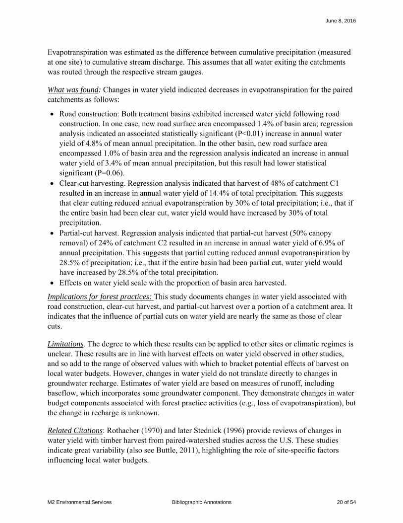
Evapotranspiration was estimated as the difference between cumulative precipitation (measured at one site) to cumulative stream discharge. This assumes that all water exiting the catchments was routed through the respective stream gauges.
What was found: Changes in water yield indicated decreases in evapotranspiration for the paired catchments as follows:
• Road construction: Both treatment basins exhibited increased water yield following road construction. In one case, new road surface area encompassed 1.4% of basin area; regression analysis indicated an associated statistically significant (P<0.01) increase in annual water yield of 4.8% of mean annual precipitation. In the other basin, new road surface area encompassed 1.0% of basin area and the regression analysis indicated an increase in annual water yield of 3.4% of mean annual precipitation, but this result had lower statistical significant (P=0.06).
• Clear-cut harvesting. Regression analysis indicated that harvest of 48% of catchment C1 resulted in an increase in annual water yield of 14.4% of total precipitation. This suggests that clear cutting reduced annual evapotranspiration by 30% of total precipitation; i.e., that if the entire basin had been clear cut, water yield would have increased by 30% of total precipitation.
• Partial-cut harvest. Regression analysis indicated that partial-cut harvest (50% canopy removal) of 24% of catchment C2 resulted in an increase in annual water yield of 6.9% of annual precipitation. This suggests that partial cutting reduced annual evapotranspiration by 28.5% of precipitation; i.e., that if the entire basin had been partial cut, water yield would have increased by 28.5% of the total precipitation.
• Effects on water yield scale with the proportion of basin area harvested.
Implications for forest practices: This study documents changes in water yield associated with road construction, clear-cut harvest, and partial-cut harvest over a portion of a catchment area. It indicates that the influence of partial cuts on water yield are nearly the same as those of clear cuts.
Limitations. The degree to which these results can be applied to other sites or climatic regimes is unclear. These results are in line with harvest effects on water yield observed in other studies, and so add to the range of observed values with which to bracket potential effects of harvest on local water budgets. However, changes in water yield do not translate directly to changes in groundwater recharge. Estimates of water yield are based on measures of runoff, including baseflow, which incorporates some groundwater component. They demonstrate changes in water budget components associated with forest practice activities (e.g., loss of evapotranspiration), but the change in recharge is unknown.
Related Citations: Rothacher (1970) and later Stednick (1996) provide reviews of changes in water yield with timber harvest from paired-watershed studies across the U.S. These studies indicate great variability (also see Buttle, 2011), highlighting the role of site-specific factors influencing local water budgets.
June 8, 2016
M2 Environmental Services Bibliographic Annotations 20 of 54

References:
Buttle, J. M., 2011, The effects of forest harvesting on forest hydrology and biogeochemistry, in Levia, D. F., Carlyle-Moses, D., and Tanaka, T., eds., Forest Hydrology and Biogeochemistry: Synthesis of Past Research and Future Directions, Springer.
Rothacher, J., 1970, Increases in water yield following clear-cut logging in the Pacific Northwest: Water Resources Research, v. 6, no. 2, p. 653-658.
Stednick, J. D., 1996, Monitoring the effects of timber harvest on annual water yield: Journal of Hydrology, v. 176, p. 79-95.
June 8, 2016
M2 Environmental Services Bibliographic Annotations 21 of 54

Bibliographic Annotation
Citation: Hunter, G., and Fell, R., 2003, Travel distance angle for "rapid" landslides in constructed and natural soil slopes: Canadian Geotechnical Journal, v. 40, p. 1123-1141.
Type of item: Peer-reviewed journal article
DOI: 10.1139/T03-061
URL: http://www.nrcresearchpress.com/doi/pdf/10.1139/t03-061
Keywords: Runout
Location: NA
Physical characteristics:
Description: Compilation of travel distances for landslides from around the world and summary of these data into empirical equations for estimating potential travel distance.
What was done:
What was found:
1. Travel distance has been described as a power function of landslide volume:
BH AVL=
where H is the vertical elevation drop from the top of the landslide source, L the horizontal travel distance, V is landslide volume, and A and B are empirical constants. They provide
coefficient values confined and unconfined debris flows for two different volume ranges. However, we do not generally have volume estimates.
They also report on the range of observed H/L ratios for different landslide types, copied below from their Table 3. Note that H/L values for unconfined debris flows range from 0.22 to 0.75. For comparison, the March 22, 2014 Oso landslide has an H/L ratio of about 0.1.
June 8, 2016
M2 Environmental Services Bibliographic Annotations 22 of 54

In evaluating equations lacking estimates of volume, they find better correlation if the angle of the slope receiving the debris is included; α2 in the diagram above. For dilative soils under three classes of confinement, they report the following equations:
20.77(tan ) 0.087HL
α= + (Standard Error SE = 0.095, r2 = 0.71; unconfined)
20.69(tan ) 0.086HL
α= + (SE = 0.110, r2 = 0.52; partly confined)
20.54(tan ) 0.147HL
α= + (SE = 0.027, r2 = 0.85; confined)
Definitions of “confined”, “partly confined”, and “unconfined” are not provided.
Implications for forest practices: These equations provide an estimate of potential runout length that can be applied, along with information from field observations, aerial photographs, and LiDAR shaded-relief interpretations, for hazard assessments.
Limitations.
Empirical equations are calibrated to specific sets of data, which may not apply locally. Ideally, equation coefficients would be developed from local data sets on landslide travel distance.
Estimates of travel distance using such techniques should report on the range of values based on uncertainty in the coefficient values. Standard errors are provided in the equations above.
June 8, 2016
M2 Environmental Services Bibliographic Annotations 23 of 54

Related Citations:
Hungr et al. (2005) provide a review of physical mechanisms that create mobile landslides, and of empirical and analytic models available for estimating travel distance, including those provided in Hunter and Fell.
Legros (2002) provides a similar compilation of landslide travel lengths. He provides equations of the form H = ALB. Nonvolcanic landslides from his compilation, for example, fit the equation H = 486L0.52, with H in meters and L in kilometers.
References
Hungr, O., Corominas, J., and Eherhardt, E., 2005, Estimating landslide motion mechanism, travel distance and velocity, in Hungr, O., Fell, R., Couture, R., and Eberhardt, E., eds., Landslide Risk Management: London, Taylor & Francis Group.
Legros, F., 2002, The mobility of long-runout landslides: Engineering Geology, v. 63, p. 301-331.
June 8, 2016
M2 Environmental Services Bibliographic Annotations 24 of 54

Bibliographic Annotation
Citation: Jassal, R. S., Black, T. A., Spittlehouse, D. L., Bradford, M., Brümmer, C., and Nesic, Z., 2009, Evapotranspiration and water use efficiency in different-aged Pacific Northwest Douglas-fir stands: Agricultural and Forest Meteorology, v. 149, no. 6, p. 1168-1178.
Type of item: Peer-reviewed journal article
DOI: 10.1016/j.agrformet.2009.02.004
URL:
Keywords: Evapotranspiration
Location: East coast of Vancouver Island, BC.
Physical characteristics:
DF49 HDF88 HDF00
Size 1.4 km2 1.1 km2 0.32 km2
Elevation 300 m 170 m 175 m
Mean Annual Precipitaton
1470 mm 1610 mm 1410 mm
Mean Annual Temperature
8.6°C 9.6°C 8.8°C
Stand Characteristics 2007
Douglas Fir 77% Cedar 18% Hemlock 4.6% Age 58 years Mean Height 33m DBH 31cm Density 1100/hectare
Douglas fir 75% Cedar 21% Grand fir 4% Age 19 years Height 7.5m DBH 8 cm Density 1200/hectare
Douglas Fir 93% Cedar 7% Age 7 years Mean height 2.4m Density 1400/hectare
Description: This paper reports on a temporal sequence of estimates of evapotranspiration and gross primary production based on eddy-covariance measurements for three different-aged Douglas-fir stands.
What was done: Vertical fluxes of water vapor, latent heat, and C02 were made continuously at three Douglas-fir stands of different ages using the eddy covariance technique. By measuring water fluxes directly, the eddy covariance technique provides direct measures of evaporation and
June 8, 2016
M2 Environmental Services Bibliographic Annotations 25 of 54

transpiration rates. Measurements were made within and above each stand at 3m, 12m, and 43m elevation. A variety of other measurements were also made to explore environmental controls on evapotranspiration and productivity. These included short and long-wave radiation, air temperature and relative humidity, soil heat flux, and volumetric soil water content (to 60cm depth).
Study sites with similar climatic and soil conditions were chosen, so that the primary difference between sites was age of the forest stand. Measurements for site DF49 were reported for the period 1998-2007; this stand was 58 years old in 2007. Measurements for site HDF88 were reported for years 2001-2007; this stand was 19 years old in 2007. Measurements for site HDF00 were reported for years 2002-2007; this stand was 7 years old in 2007.
What was found: Figure 1 shows measured annual precipitation and evapotranspiration for each site.
Figure 4 Annual precipitation and evapotranspiration (ET) depth for each of the three monitoring sites. Blue symbols indicate precipitation, green indicate evapotranspiration. Symbol shape indicates monitoring site; numbers in parentheses in the legend indicate stand age for each site in 2007. Data from Table 1 in the paper.
Interannual variability in precipitation is greater than that for evapotranspiration, and there is no clear relationship between evapotranspiration and cumulative precipitation. Rather, high rates of evapotranspiration occur with more evenly distributed time series of rainfall events and with high average solar irradiance.
The 58 and 19-year-old stands (in 2007) have similar evapotranspiration amounts; however, evapotranspiration from the youngest stand (7 years in 2007) is distinctly lower. This is illustrated in Figure 2 below.
0200400600800
100012001400160018002000
1998 1999 2000 2001 2002 2003 2004 2005 2006 2007
mm
/yr
Year
Annual Precipitation and ET
DF49 (58)
HDF88 (19)
HDF00 (7)
June 8, 2016
M2 Environmental Services Bibliographic Annotations 26 of 54
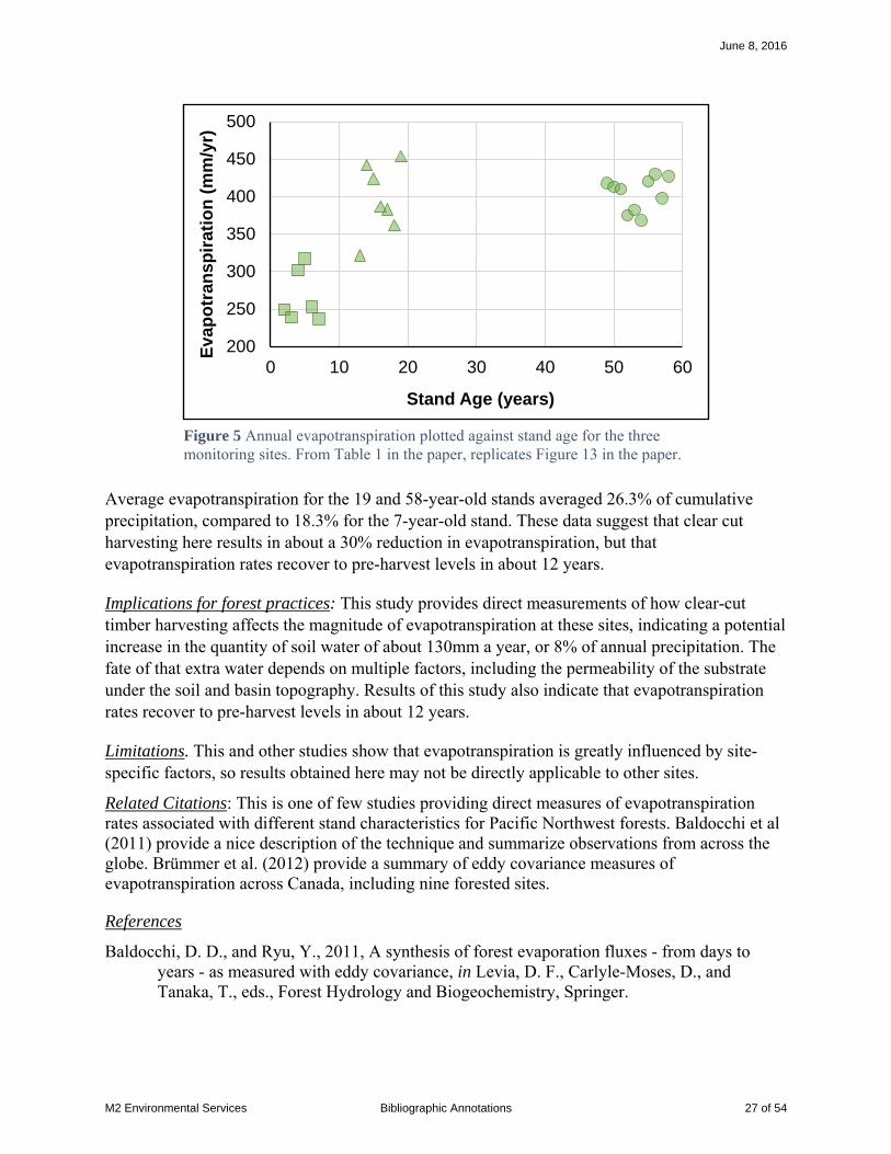
Average evapotranspiration for the 19 and 58-year-old stands averaged 26.3% of cumulative precipitation, compared to 18.3% for the 7-year-old stand. These data suggest that clear cut harvesting here results in about a 30% reduction in evapotranspiration, but that evapotranspiration rates recover to pre-harvest levels in about 12 years.
Implications for forest practices: This study provides direct measurements of how clear-cut timber harvesting affects the magnitude of evapotranspiration at these sites, indicating a potential increase in the quantity of soil water of about 130mm a year, or 8% of annual precipitation. The fate of that extra water depends on multiple factors, including the permeability of the substrate under the soil and basin topography. Results of this study also indicate that evapotranspiration rates recover to pre-harvest levels in about 12 years.
Limitations. This and other studies show that evapotranspiration is greatly influenced by site-specific factors, so results obtained here may not be directly applicable to other sites.
Related Citations: This is one of few studies providing direct measures of evapotranspiration rates associated with different stand characteristics for Pacific Northwest forests. Baldocchi et al (2011) provide a nice description of the technique and summarize observations from across the globe. Brümmer et al. (2012) provide a summary of eddy covariance measures of evapotranspiration across Canada, including nine forested sites.
References
Baldocchi, D. D., and Ryu, Y., 2011, A synthesis of forest evaporation fluxes - from days to years - as measured with eddy covariance, in Levia, D. F., Carlyle-Moses, D., and Tanaka, T., eds., Forest Hydrology and Biogeochemistry, Springer.
200
250
300
350
400
450
500
0 10 20 30 40 50 60
Eva
po
tran
spir
atio
n (
mm
/yr)
Stand Age (years)
Figure 5 Annual evapotranspiration plotted against stand age for the three monitoring sites. From Table 1 in the paper, replicates Figure 13 in the paper.
June 8, 2016
M2 Environmental Services Bibliographic Annotations 27 of 54

Brümmer, C., Black, T. A., Jassal, R. S., Grant, N. J., Spittlehouse, D. L., Chen, B., Nesic, Z., Amiro, B. D., Arain, M. A., Barr, A. G., Bourque, C. P.-A., Coursolle, C., Dunne, A. L., Flanagan, L. B., Humphreys, E. R., Lafleur, P. M., Margolis, H. A., McCaughey, J. H., and Wofsy, S. C., 2012, How climate and vegetation type influence evapotranspiration and water use efficiency in Canadian forest, peatland and grassland ecosystems: Agricultural and Forest Meteorology, v. 153, p. 14-30.
June 8, 2016
M2 Environmental Services Bibliographic Annotations 28 of 54

Bibliographic Annotation
Citation: LaHusen, S. R., A. R. Duvall, A. M. Booth, and D. R. Montgomery (2016), Surface roughness dating of long-runout landslides near Oso, Washington (USA), reveals persistent postglacial hillslope instability, Geology, 44(2), 111-114.
Type of item: Journal Article
DOI: 10.1130/G37267.1
URL: http://geology.gsapubs.org/content/44/2/111.short
Keywords: LiDAR, surface roughness, landslide dating, recurrence
Location: North Fork Stillaguamish River, Washington
Physical characteristics: In the vicinity of this study, the North Fork Stillaguamish Valley contains a thick sequence (nearly 200 m) of glacialacustrine, outwash, and till deposits. The river has eroded through these deposits since deglaciation ~12,000 years before present, leaving large relict glacial deposits lining the valley sides. These deposits are lined with large, deep-seated landslides. In March of 2014, the Hazel landslide near Oso failed as a rapid, long-runout debris-avalanche flow (Keaton et al., 2014).
Description: The authors estimate a recurrence interval for large deep-seated landslides in deep glacial sediments lining the North Fork Stillaguamish valley. Their estimate is based on correlation of LiDAR-derived landslide-deposit surface roughness with radiocarbon-determined landslide ages.
What was done:
• Landslide features were mapped from 0.9m-resolution bare-earth LiDAR imagery for 25 landslides identified from the imagery in the vicinity of the 2014 Oso landslide. Surface roughness over these landslide deposits was calculated using standard deviation of surface slope over a 15 x 15m roving window. Average roughness values were calculated for each landslide deposit.
• Wood fragments were collected for 14C dating from two landslide deposits and from a river terrace that underlies all landslide deposits. The terrace provides an upper limit on landslide ages, the two deposits were dated at ~520 and ~6000 calendar years before present, and the Oso landslide provides a zero-age deposit. Their goal was to relate these ages to the average surface-roughness values.
• To determine the optimal shape of the curve relating surface roughness and landslide age, a numerical landscape evolution model was applied to the Oso landslide deposit. This model assumes that topographic features diffuse over time at a rate proportional to the change in surface slope with distance (the profile curvature). This model generates an exponentially shaped curve for the decrease in average surface roughness over time. The proportionality constant setting the rate of diffusion was set to give the best match with
June 8, 2016
M2 Environmental Services Bibliographic Annotations 29 of 54

the surface roughness found for the sites with three deposits with known ages and the lowest measured average roughness associated with the terrace age. This exercise yielded a curve relating average deposit surface roughness to landslide age.
• The authors then applied this relationship to estimate ages for the remaining 22 mapped landslides.
What was found: Over the entire 12,000-year record, the average recurrence interval calculated for landslides in this vicinity is 500 years. Over the last 2000 years, the recurrence interval is 140 years.
Implications for forest practices:. Evidence indicating periodicity and rates of landslide activity are key factors in identifying sites that pose hazards and for inferring sensitivity to forest practices. These authors show that LiDAR-derived measurements to characterize surface roughness of mapped landslide deposits may correlate with landslide age.
Limitations. The time resolution and accuracy of such topography-based estimates of landslide age are not yet determined. Other studies point to limitations of this approach (Goetz et al., 2014).
Related Citations: Experience with use of LiDAR imagery for landslide mapping and for characterizing landslide deposits is rapidly evolving (Jaboyedoff et al., 2012). LiDAR-derived shaded relief images are used to manually map landslide locations, as done for this study and others (e.g., Burns and Madin, 2009; Gerstel and Badger, 2014; Haugerud, 2014; McKenna et al., 2008; Schulz, 2007). Measures of surface features have also been used to automatically identify landslide locations (Berti and Daehne, 2013; Booth et al., 2009; McKean and Roering, 2004) and to differentiate landslide behavior (Glenn et al., 2006).
Berti, M. C., Alessandro, and Daehne, A., 2013, Comparative analysis of surface roughness algorithms for the identification of active landslides: Geomorphology, v. 182, p. 1-18.
Booth, A. M., Roering, J. J., and Perron, J. T., 2009, Automated landslide mapping using spectral analysis and high-resolution topographic data: Puget Sound lowlands, Washington, and Portland Hills, Oregon: Geomorphology.
Burns, W. J., and Madin, I. P., 2009, Protocol for inventory mapping of landslide deposits from light detection and ranging (lidar) imagery: Oregon Department of Geology and Mineral Industries.
Gerstel, W. J., and Badger, T. C., 2014, Reconnaissance mapping and characterization of landslides along State Route 530 between mileposts 35 and 41, Snohomish County, Washington: Washington Department of Transportaion, Geotechnical Office.
Glenn, N. F., Streutker, D. R., Chadwich, D. J., Thackray, G. D., and Dorsch, S. J., 2006, Analysis of LiDAR-derived topographic information for characterizing and differentiating landslide morphology and activity: Geomorphology, v. 73, p. 131-148.
Goetz, J. N., Bell, R., and Brenning, A., 2014, Could surface roughness be a poor proxy for landslide age? Results from teh Swabian Alb, Germany: Earth Surface Processes and Landforms.
June 8, 2016
M2 Environmental Services Bibliographic Annotations 30 of 54

Haugerud, R. A., 2014, Preliminary Interpretation of Pre-2014 Landslide Deposits in the Vicinity of Oso, Washington: U.S. Geological Survey.
Jaboyedoff, M., Oppikofer, T., Abellan, A. D., Marc-Henri, Loye, A., Metzger, R., and Pedrazzini, A., 2012, Use of LiDAR in landslide investigations: a review: Natural Hazards, v. 61, p. 5-28.
Keaton, J. R., Wartman, J., Anderson, S. A., Benoît, J., deLaChapelle, J., Gilbert, R., and Montgomery, D. R., 2014, The 22 March 2014 Oso Landslide, Snohomish County, Washington: National Science Foundation.
McKean, J., and Roering, J., 2004, Objective landslide detection and surface morphology mapping using high-resolution airborne laser altimetry: Geomorphology, v. 57, p. 331-351.
McKenna, J. P., Lidke, D. J., and Coe, J. A., 2008, Landslides mapped from LIDAR imagery, Kitsap County, Washington: U.S. Geological Survey.
Schulz, W. H., 2007, Landslide susceptibility revealed by LIDAR imagery and historical records, Seattle, Washington: Engineering Geology, v. 89, p. 67-87.
June 8, 2016
M2 Environmental Services Bibliographic Annotations 31 of 54

Bibliographic Annotation
Citation: Link, T. E., M. Unsworth, and D. Marks (2004), The dynamics of rainfall interception by a seasonal temperate rainforest, Agricultural and Forest Meteorology, v124, p171-191.
Type of item: Peer-reviewed journal article
DOI: 10.1016/j.agrformet.2004.01.010
URL: http://www.fs.fed.us/pnw/pubs/journals/pnw_2004_link001.pdf
Keywords: interception loss
Location: Gifford Pinchot National Forest, southwest Washington
Physical characteristics: Elevation: 367.5m Mean annual precipitation: 2476mm (97.5in) (PRISM 2270mm, 89.4in) Mean annual temperature: 8.7°C (47.7°F) (PRISM 9.44°C, 49.0°F) Forest: 500-year-old stand: Douglas fir, western hemlock, and western red cedar 60m canopy height
Description: This study sought to determine effects of stand characteristics on net interception of rainfall by the forest canopy.
What was done: Throughfall was determined as the difference of gross rainfall measured in a nearby clearing to rainfall measured using large roving arrays of automated and manual rain gauges under the forest canopy. Measurements were made with high temporal resolution so that cumulative gross rainfall and throughfall could be monitored during individual rainfall events. These data were used with several standard techniques to estimate direct throughfall (the proportion of rainfall that falls directly through gaps in the canopy), canopy storage, and evaporation rates.
Meteorological data were collected at five elevations within and above the forest canopy using instruments mounted on the 85-m-tall research crane present at the site.
What was found:
• Cumulative interception losses for this stand were calculated as 22.8% and 25.0% of total measured precipitation for monitoring periods in 1999 and 2000.
• Interception losses for individual storm events monitored in 2000 ranged from 7.5% to 97.1% of event precipitation.
• Spatially averaged storage capacity of the stand varied over the course of the year from about 3 mm precipitation depth in the winter to about 4 mm during the summer.
• Spatially averaged direct throughfall (raindrops that fall directly through gaps in the canopy) for this stand had an event-averaged value of 36%
June 8, 2016
M2 Environmental Services Bibliographic Annotations 32 of 54

Interception losses for individual events depends on the proportion of rainfall that travels through gaps in the canopy as direct throughfall, on the amount of rainfall relative to the volume of water that can be stored in the tree canopy, on the amount of water in the canopy at the start of the event, and on the rate at which water can evaporate from the canopy during the rainstorm. The cumulative interception loss over a sequence of rainfall events thus depends on characteristics of the stand itself (direct throughfall, canopy storage) and on the frequency distribution of rainfall-event magnitudes, durations, and inter-event time intervals.
The authors show that accuracy of a model (the Gash model) to estimate canopy interception depends very much on the degree to which the timing and duration of rainfall events is accounted for in the model. Use of daily mean values in the model, rather than use of individual rainfall events – which may span several days – resulted in much lower accuracy.
Implications for forest practices: The loss of tree canopy associated with timber harvest reduces interception losses, so that a greater proportion of precipitation falls to the ground surface. Interception loss is only one component of the water budget: evaporation of water from the ground surface and transpiration of water by plants both act to extract water from the soil. However, other studies (e.g., Bauer and Mastin, 1997) indicate that the magnitude of these two components do not differ substantially for different vegetated land covers, so a reduction in interception loss may be translated almost directly to increased inputs to soil water.
This and other studies show that interception losses for coniferous forests range from 20% to 50% of total precipitation, so harvest-related reductions of interception loss can substantially increase the quantity of water that infiltrates the soil. That 20 to 50% range, however, indicates that the magnitude of that increase depends on site-specific factors. This study identifies two things, in particular, that control interception losses: 1) the sequence of rainfall events – their duration, their magnitude (precipitation depth), and the time between events, and 2) the volume of water that can be stored in tree canopy relative to that sequence of rainfall events.
Limitations. This study highlights the sensitivity of canopy interception to the interplay of stand characteristics (direct throughfall, canopy storage) with the timing, duration, and magnitude of rainfall events. The interception losses measured at this site cannot be directly applied to other sites.
Related Citations: Pypker et al. (2005) compare results of this study to similar analysis of a nearby young (25-year-old) Douglas-fir stand. Interception losses for the young stand were estimated as 21.4%; very similar to those found in this study for a 500-year-old stand. Bauer and Mastin (1997) estimated interception losses using measures of cumulative throughfall for a 60-70 year-old Douglas fir stand in south Puget Sound of 47%; Orr et al. (2002) estimated interception losses in north Kitsap Peninsula of 14% for a 15-30 year-old stand, of 41% for a 50-100 year-old stand, and of 25% for an old-growth stand.
June 8, 2016
M2 Environmental Services Bibliographic Annotations 33 of 54

Bauer, H. H., and Mastin, M. C., 1997, Recharge from precipitation in three small glacial-till-mantled catchments in the Puget Sound lowland, Washington: U.S. Geological Survey.
Orr, L. A., Bauer, H. H., and Wayenberg, J. A., 2002, Estimates of ground-water recharge from precipitation to glacial-deposit and bedrock aquifers on Lopez, San Juan, Orcas, and Shaw islands, San Juan County, Washington: US Geological Survey.
Pypker, T. G., bond, B. J., Link, T. E., Marks, D., and Unsworth, M. H., 2005, The importance of canopy structure in controlling the interception loss of rainfall: Examples from a young and an old-growth Douglas-fir forest: Agricultural and Forest Meteorology, v. 130, p. 113-129.
June 8, 2016
M2 Environmental Services Bibliographic Annotations 34 of 54

Bibliographic Annotation
Citation: Miller, D. J., and Sias, J., 1998, Deciphering large landslides: linking hydrological, groundwater and slope stability models through GIS: Hydrological Processes, v. 12, p. 923-941.
Type of item: Peer-reviewed journal article
DOI:
URL:
Keywords: Coupled models, evapotranspiration,
Location: Hazel Landslide (SR530 landslide), Stillaguamish Valley, Washington
Physical characteristics:
Mean annual precipitation: 2250 mm
Description: A modeling exercise to examine the sensitivity of the Hazel landslide to forest practices, river incision of the toe, and incision of channels over the body of the landslide.
Full disclosure: I am the first author of this paper, so my perceptions may be somewhat biased.
What was done:
1) A soil-moisture water-balance model was constructed to estimate evapotranspiration rates for a “typical, non-species-specific coniferous forest (i.e. 20-40 m tall, single-layer, closed canopy) and a revegetated clear-cut (i.e., having a short, deciduous canopy and no overstorey)” for this location. Lower and upper bounds were calculated based on lower and upper bounds in the range of uncertainties in model parameters. (Meteorological data were from the Darrington weather station, 11 miles east of the site).
2) Recharge was determined as precipitation minus evapotranspiration. Recharge was applied to an areal 2-D groundwater model (MODFE). Boundary conditions for the model were based on surface topography and subsurface stratigraphy was based on extrapolation of seepage face locations, inferred to indicate contacts between outwash and lacustrine sediments. Material properties were based on published values for similar materials. The model was applied to estimate water-table elevations for the minimum and maximum estimated average recharge values for both steady-state and transient simulations over the 60-year period of meteorological data. The recharge area was delineated using water-table elevations.
3) A 2-D limit-equilibrium stability model (Bishop’s simplified method of slices) was used to identify the minimum factor of safety value for each point on the landslide using thousands of transects. Factor of safety values were calculated over the entire landslide area for steady-state groundwater simulations using the minimum and maximum calculated time-averaged recharge values. Stability was evaluated in terms of the relative
June 8, 2016
M2 Environmental Services Bibliographic Annotations 35 of 54
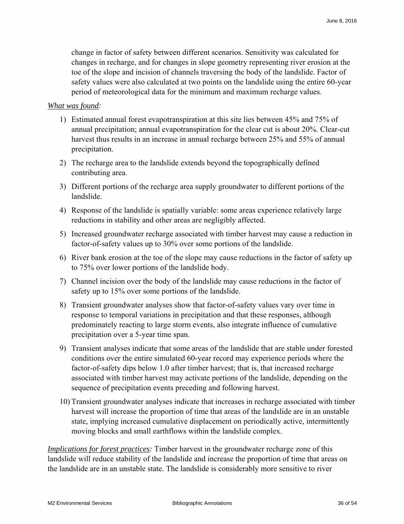
change in factor of safety between different scenarios. Sensitivity was calculated for changes in recharge, and for changes in slope geometry representing river erosion at the toe of the slope and incision of channels traversing the body of the landslide. Factor of safety values were also calculated at two points on the landslide using the entire 60-year period of meteorological data for the minimum and maximum recharge values.
What was found:
1) Estimated annual forest evapotranspiration at this site lies between 45% and 75% of annual precipitation; annual evapotranspiration for the clear cut is about 20%. Clear-cut harvest thus results in an increase in annual recharge between 25% and 55% of annual precipitation.
2) The recharge area to the landslide extends beyond the topographically defined contributing area.
3) Different portions of the recharge area supply groundwater to different portions of the landslide.
4) Response of the landslide is spatially variable: some areas experience relatively large reductions in stability and other areas are negligibly affected.
5) Increased groundwater recharge associated with timber harvest may cause a reduction in factor-of-safety values up to 30% over some portions of the landslide.
6) River bank erosion at the toe of the slope may cause reductions in the factor of safety up to 75% over lower portions of the landslide body.
7) Channel incision over the body of the landslide may cause reductions in the factor of safety up to 15% over some portions of the landslide.
8) Transient groundwater analyses show that factor-of-safety values vary over time in response to temporal variations in precipitation and that these responses, although predominately reacting to large storm events, also integrate influence of cumulative precipitation over a 5-year time span.
9) Transient analyses indicate that some areas of the landslide that are stable under forested conditions over the entire simulated 60-year record may experience periods where the factor-of-safety dips below 1.0 after timber harvest; that is, that increased recharge associated with timber harvest may activate portions of the landslide, depending on the sequence of precipitation events preceding and following harvest.
10) Transient groundwater analyses indicate that increases in recharge associated with timber harvest will increase the proportion of time that areas of the landslide are in an unstable state, implying increased cumulative displacement on periodically active, intermittently moving blocks and small earthflows within the landslide complex.
Implications for forest practices: Timber harvest in the groundwater recharge zone of this landslide will reduce stability of the landslide and increase the proportion of time that areas on the landslide are in an unstable state. The landslide is considerably more sensitive to river
June 8, 2016
M2 Environmental Services Bibliographic Annotations 36 of 54

erosion of the toe, and also sensitive to incision of channels draining the landslide. Each of these factors affect different portions of the landslide and may act in concert, i.e., the combined effects of bank erosion at the river, channel incision over the body, and increased recharge from timber harvest during a series of wet years may all combine to cause landslide activity that would not occur for in association with any single factor alone.
Limitations.
1) This study relied on stratigraphy inferred from surface observations. That inferred stratigraphy turned out to be incorrect. A simple sequence of advance outwash overlying lacustrine deposits was inferred. In fact, the seeps used to establish the contact elevations represented a contact between recessional outwash and till. The till overlies advance outwash, which overlies lacustrine deposits (WSDOT, 2015). Hence, the groundwater model represented an unconfined aquifer in the recessional outwash, but included no influences from the confined aquifer in advance outwash below (which the 2-D model could not have accommodated). This may not change the conclusion drawn from the study, but it highlights the uncertainties involved in applying models with incomplete information.
2) Parameters for the water-balance model relied on published values. The estimated forested evapotranspiration rates are consistent with values measured since that time; the 20% value for clear-cut conditions may be somewhat low, resulting in estimates of increased recharge somewhat higher than other regional studies suggest (e.g., Bidlake and Payne, 2001).
3) Changes in recharge were applied in a spatially uniform manner. This is not representative of actual harvest practices. This limitation was recognized in the paper and was a consequence of the limited computing resources available at the time.
4) Percolation through the unsaturated zone was not modeled. Effects of moisture storage in the soil were included in the water balance, but water flow through the unsaturated zone may have an important influence on the timing and magnitude of pore pressure responses at depth.
5) Results of the modeling were never tested with field monitoring. The models suggested that activity on the landslide would vary in predictable spatial and temporal patterns. It predicted a water-table response to precipitation that could be verified with monitor wells.
Related Citations:
This study is described in more detail in a report submitted to the Hazel watershed analysis team (Miller and Sias, 1997). Details of the stability model are described in Miller (1995).
Brien and Reid (2007; 2008) describe linking of a 3-D groundwater model with a 3-D slope stability model to evaluate susceptibility to deep-seated landslides for areas around Seattle. Their modeling did not include a soil-moisture water-balance model.
Although a number of models have been developed linking shallow-soil pore-pressure dynamics and slope stability(van Asch et al., 2007) for hazard assessment, no similar broadly applicable models have been developed for deep-seated landslides. Detailed geotechnical models can link
June 8, 2016
M2 Environmental Services Bibliographic Annotations 37 of 54

hydrologic and slope failure processes (e.g., Davies et al., 2014), but these are not broadly applied because of the large amount of input data required.
Several studies have coupled soil-water-balance models with groundwater flow models. Batelaan and De Smedt (2007) describe GIS-based methods for linking a spatially distributed surface hydrology model with MODFLOW. Malet et al. (2005) link a surface hydrology model to a groundwater model designed specifically for the Super-Sauze earthflow in the French Alps to better forecast earthflow behavior. Vallet et al. (2015) developed a GIS-based workflow for building spatially distributed soil-moisture-balance models for the purpose of improved prediction of landslide activation.
Bogaard (2001) linked a 1-D model for unsaturated flow with a 2-D groundwater model to examine groundwater responses to changes in climate and land use. These were coupled with an infinite-slope stability model to better explain observed landslide responses to precipitation.
Bogaard and Greco (2016) discuss the current state of knowledge for landslide hydrology. They discuss the need to examine “landslide catchments” in order to understand landslide dynamics, the poorly understood role of nonlinear aspects of groundwater flow created by preferential flow pathways, and the need to upscale current deterministic models of soil mechanics to match the conceptual models of hillslope hydrology.
Hazel is the site of the March 22, 2014 Oso (SR530) landslide, for which a number of papers have been and continue to be published. I’ll not cite them here, because the focus of the Miller and Sias 1998 work was on sensitivity to forest practices, not on hazard assessment and landslide mobility.
References
Batelaan, O., and De Smedt, F., 2007, GIS-based recharge estimation by coupling surface–subsurface water balances: Journal of Hydrology, v. 337, no. 3-4, p. 337-355.
Bidlake, W. R., and Payne, K. L., 2001, Estimating recharge to ground water from precipitation at Naval Submarine Base Bangor and vicinity, Kitsap County, Washington, 2001-4110.
Bogaard, T., 2001, Analysis of hydrological processes in unstable clayey slopes [Doctor: Universiteit Utrecht.
Bogaard, T. A., and Greco, R., 2016, Landslide hydrology: from hydrology to pore pressure: Wiley Interdisciplinary Reviews: Water, v. 3, no. 3, p. 439-459.
Brien, D. L., and Reid, M. E., 2007, Modeling 3-D Slope Stability of Coastal Bluffs, Using 3-D Ground-Water Flow, Southwestern Seattle, Washington: U.S. Geological Survey.
Brien, D. L., and Reid, M. E., 2008, Assessing deep-seated landslide susceptibility using 3-D groundwater and slope-stability analyses, southwestern Seattle, Washington: Reviews in Engineering Geology, v. 20, p. 83-101.
June 8, 2016
M2 Environmental Services Bibliographic Annotations 38 of 54

Davies, O., Rouainia, M., Glendinning, S., Cash, M., and Trento, V., 2014, Investigation of a pore-pressure driven slope failure using a coupled hydro-mechanical model: Engineering Geology, v. 178, p. 70-81.
Malet, J.-P., van Asch, T. W. J., van Beek, R., and Maquaire, O., 2005, Forecasting the behaviour of complex landslides with a spatially distributed hydrological model: Natural Hazards and Earth Systems Sciences, v. 5, p. 71-85.
Miller, D., and Sias, J., 1997, Environmental Factors Affecting the Hazel Landslide. Level 2 Watershed Analysis Report.
Miller, D. J., 1995, Coupling GIS with physical models to assess deep-seated landslide hazards: Environmental & Engineering Geoscience, v. 1, no. 3, p. 263-276.
Vallet, A., Bertrand, C., Fabbri, O., and Mudry, J., 2015, An efficient workflow to accurately compute groundwater recharge for the study of rainfall-triggered deep-seated landslides, application to the Séchilienne unstable slope (western Alps): Hydrol. Earth Syst. Sci., v. 19, p. 427-449.
van Asch, T. W. J., Malet, J.-P., van Beek, L. P. H., and Amitrano, D., 2007, Techinques, issues and advances in numerical modelling of landslide hazard: Bulletin de la Société Géologique de France, v. 178, no. 2, p. 65-88.
WSDOT, 2015, SR 530 MP 35 to 41 Geotechnical Study: Washington State Department of Transportation.
June 8, 2016
M2 Environmental Services Bibliographic Annotations 39 of 54

Bibliographic Annotation
Citation: Orr, L. A., H. H. Bauer, and J. A. Wayenberg (2002), Estimates of ground-water recharge from precipitation to glacial-deposit and bedrock aquifers on Lopez, San Juan, Orcas, and Shaw islands, San Juan County, Washington. US Geological Survey Water-Resources Investigations Report 02-4114, 113 pp.
Type of item: US Geological Survey report
DOI:
URL: http://pubs.usgs.gov/wri/wri024114/pdf/WRIR02-4114.pdf
Keywords: groundwater recharge, throughfall, interception
Location: San Juan Islands
Physical characteristics: Characteristics of the three throughfall measurement sites:
Lopez Shaw Orcas
Elevation 55 m (180 ft) 53 m (174 ft) 130 m (427 ft)
Mean annual precipitation (PRISM)
520 mm (20.5 in) 600 mm (23.6 in) 820 mm (32.3 in)
Mean annual temperature (PRISM)
10.5°C (50.9°F) 10.2°C (50.4°F) 10.3°C (50.5°F)
Stand age 15 – 30 years 50-100 years Old growth
Description: This report documents calculations to estimate groundwater recharge of glacial-deposit and bedrock aquifers on the San Juan Islands using two independent methods: 1) a water-balance calculation and 2) a chloride mass-balance calculation.
What was done: A soil-moisture water budget was computed using the Deep Percolation Model (DPM, Bauer and Mastin, 1997; Bauer and Vaccaro, 1987). Data for calibration and validation included streamflow for water years 1997-98 gaged at 6 small basins, two temporary micrometeorological stations used to collect hourly weather data, and precipitation throughfall measurements collected at three forested sites. Water-budget components were calculated for representative soil, substrate, and landcover combinations for the six small study basins, and these results then extrapolated to the entire area.
Recharge estimates based on water-budget computations were compared to recharge estimated for Lopez Island from choride concentrations measured in groundwater from island wells.
What was found: An important result from this study were measurements of cumulative precipitation throughfall at three forested sites. These measures can be interpreted in terms of cumulative interception loss as follows:
June 8, 2016
M2 Environmental Services Bibliographic Annotations 40 of 54
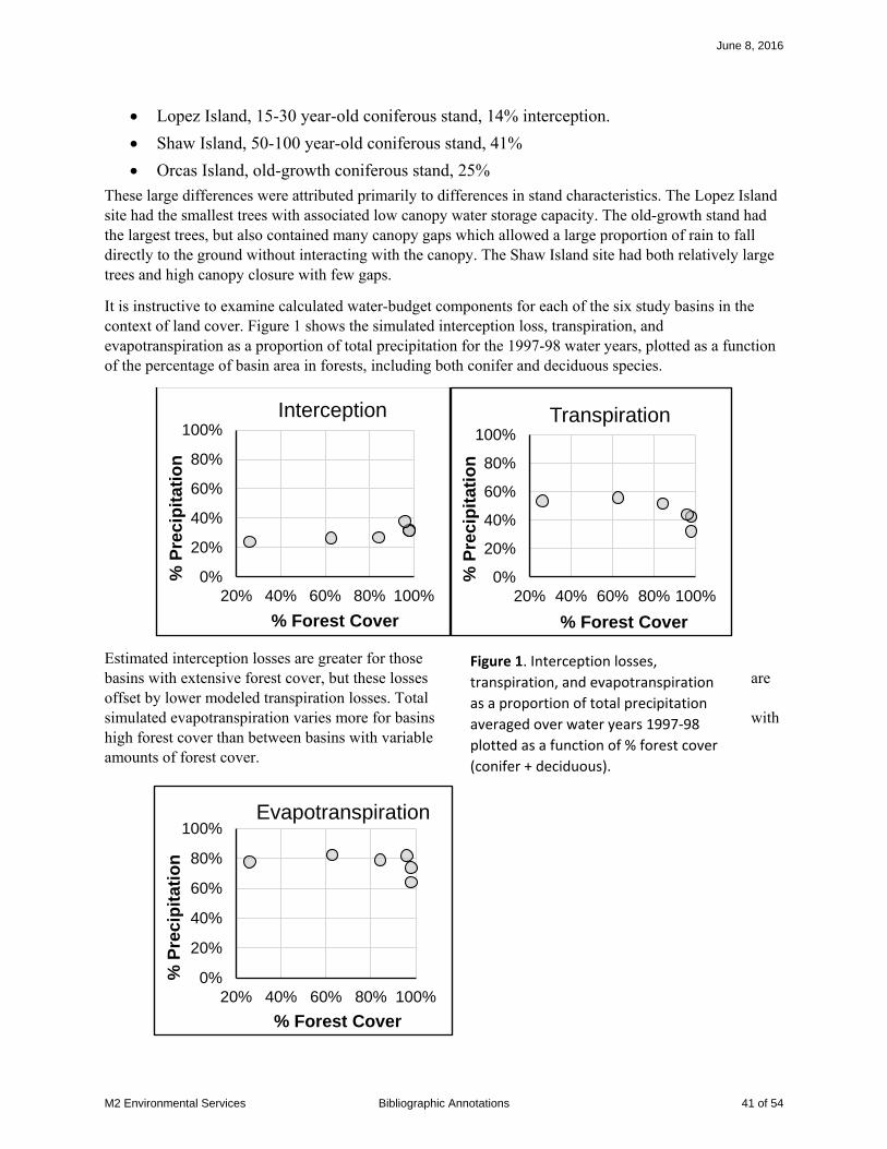
• Lopez Island, 15-30 year-old coniferous stand, 14% interception. • Shaw Island, 50-100 year-old coniferous stand, 41% • Orcas Island, old-growth coniferous stand, 25%
These large differences were attributed primarily to differences in stand characteristics. The Lopez Island site had the smallest trees with associated low canopy water storage capacity. The old-growth stand had the largest trees, but also contained many canopy gaps which allowed a large proportion of rain to fall directly to the ground without interacting with the canopy. The Shaw Island site had both relatively large trees and high canopy closure with few gaps.
It is instructive to examine calculated water-budget components for each of the six study basins in the context of land cover. Figure 1 shows the simulated interception loss, transpiration, and evapotranspiration as a proportion of total precipitation for the 1997-98 water years, plotted as a function of the percentage of basin area in forests, including both conifer and deciduous species.
Estimated interception losses are greater for those basins with extensive forest cover, but these losses are offset by lower modeled transpiration losses. Total simulated evapotranspiration varies more for basins with high forest cover than between basins with variable amounts of forest cover.
0%
20%
40%
60%
80%
100%
20% 40% 60% 80% 100%
% P
reci
pit
atio
n
% Forest Cover
Interception
0%
20%
40%
60%
80%
100%
20% 40% 60% 80% 100%
% P
reci
pit
atio
n
% Forest Cover
Transpiration
0%
20%
40%
60%
80%
100%
20% 40% 60% 80% 100%
% P
reci
pit
atio
n
% Forest Cover
Evapotranspiration
Figure 1. Interception losses, transpiration, and evapotranspiration as a proportion of total precipitation averaged over water years 1997-98 plotted as a function of % forest cover (conifer + deciduous).
June 8, 2016
M2 Environmental Services Bibliographic Annotations 41 of 54

Another important result of the water-budget modeling is that recharge to groundwater is largely governed by permeability of the substrate beneath the soil. Figure 2 shows modeled recharge versus evapotranspiration, both in terms of the percentage of annual precipitation, for each simulation year for the six study basins. Those underlain by glacial sediments have much higher recharge rates, and there is no apparent relationship between recharge and evapotranspiration.
Implications for forest practices: This study contributes to the set of measurements of interception loss for forests in the Pacific Northwest. Throughfall is the proportion of rainfall that falls through the canopy to the forest floor; total precipitation minus throughfall averaged over time provides a measure of interception loss – the proportion of rainfall that is intercepted by tree canopy and evaporated back into the atmosphere. As shown by measurements of throughfall made in this and other studies, interception losses
account for a substantial portion of the total precipitation. With removal of forest cover, interception losses go essentially to zero. Estimates of interception loss provide a measure of how much additional water will infiltrate into the soil, as a proportion of annual precipitation, following clear-cut timber harvests.
However, the simulation results using the Deep Percolation Model calibrated to the study basins also suggests that reductions in interception may be offset by increases in transpiration, as shown in Figure 1 above. These are simulated results, but calibrated against observed stream flow.
As seen in the results of this study, measures of interception loss (as a proportion of total precipitation) vary greatly from site to site. These variations arise in part from differences in forest canopy characteristics, as assumed in this case, and also from differences in the timing, duration, and magnitude of rainfall events.
Limitations. These results suggest that interception loss may be related to stand age. However, Pypker et al. (2005) found interception losses for a 25-year-old and a nearby 500-year-old stand in southwest Washington to be remarkably similar (23% and 25%, respectively), so there are confounding factors that preclude any simple extrapolation of these results. The primary lesson is that measured interception losses vary over a large range, from 14% to 41% of total precipitation in this case (and up to 47% in others, Bauer and Mastin, 1997).
0%
2%
4%
6%
8%
10%
12%
14%
16%
50% 60% 70% 80% 90% 100%
Rec
har
ge
as %
Pre
cip
ET as % Precipitation
Recharge vs EvapoTranspiration (ET)Bedrock and Glacial Substrates
Glacial Substrate
Bedrock Substrate
Figure 2. Modeled recharge to groundwater versus modeled evapotranspiration, both in terms of annual precipitation, for the two simulation water years (1997-98) for the six study basins.
June 8, 2016
M2 Environmental Services Bibliographic Annotations 42 of 54
However, this study also shows that changes in interception do not translate directly to changes in soil-moisture inputs or to changes in recharge. Permeability of the substrate underlying the soil is the primary controlling factor.
Related Citations: This study is one in a set of USGS Water Resources Investigation Reports that document measurements and modeling done using the Deep Percolation Model to estimate recharge rates for locations in Puget Sound: Bauer and Mastin (1997) provided a detailed examination of water-budgeting procedures for three small basins underlain by glacial till in south Puget Sound; Bidlake and Payne (2001) computed water budgets for an area in the north Kitsap Peninsula, and Sumioka and Bauer (2004) computed water budgets for Whidbey and Camano Islands.
References
Bauer, H. H., and Mastin, M. C., 1997, Recharge from precipitation in three small glacial-till-mantled catchments in the Puget Sound lowland, Washington: U.S. Geological Survey.
Bauer, H. H., and Vaccaro, J., 1987, Documentation of a deep percolation model for estimating ground-water recharge: US Geological Survey, 2331-1258.
Bidlake, W. R., and Payne, K. L., 2001, Estimating recharge to ground water from precipitation at Naval Submarine Base Bangor and vicinity, Kitsap County, Washington, 2001-4110.
Pypker, T. G., bond, B. J., Link, T. E., Marks, D., and Unsworth, M. H., 2005, The importance of canopy structure in controlling the interception loss of rainfall: Examples from a young and an old-growth Douglas-fir forest: Agricultural and Forest Meteorology, v. 130, p. 113-129.
Sumioka, S. S., and Bauer, H. H., 2004, Estimating Ground-Water Recharge from Precipitation on Whidbey and Camano Islands, Island County, Washington, Water Years 1998 and 1999.
June 8, 2016
M2 Environmental Services Bibliographic Annotations 43 of 54

Bibliographic Annotation
Citation: Picarelli, L., Urciuoli, G., and Russo, C., 2004, Effect of groundwater regime on the behaviour of clayey slopes: Canadian Geotechnical Journal, v. 41, p. 467-484.
Type of item: Peer-reviewed journal article
DOI: 10.1139/T04-009
URL:
Keywords: progressive failure, fatigue weakening, pore-pressure cycling
Location: NA
Physical characteristics: NA
Description: This paper describes how changes in pore pressure may affect the mechanical properties of certain types of soils, which include many glacial-lacustrine deposits, and implications for landslide behavior.
What was done: Review of past work.
What was found:
Prefailure.
• Fatigue. Seasonal variations of water-table elevations in a slope result in cyclic variations in pore pressures within the soil. In structured soils, such as overconsolidated clays, this cyclic variation of effective stress causes structural changes within the soil and an associated reduction of strength over time. Reduction of soil strength causes a decrease in slope stability, as illustrated using the factor of safety in Figure 1c (reproduced here).
• Creep. Pore-pressure variations cause small displacements within the soil. For soils on a slope, these are manifest as soil creep. If soil strength decreases over time in response to pore-pressure variations, the rate of creep will increase.
• Progressive Failure. Stress fields vary within a slope in a manner dependent on topography, hydrology, and properties of the materials composing the slope – all of which depend on the history of events experienced by that hillslope. As stress fields change in response to changes in topography from erosion, earthquakes, and transient high pore pressures, and as material
Figure 6. Change in the factor of safety over time caused by cyclic variation of pore pressures associated with seasonal fluctuations of water table levels.
June 8, 2016
M2 Environmental Services Bibliographic Annotations 44 of 54

properties of the soil evolve in response to changing stresses, local zones of failure can occur within a slope. Thus, as the authors state: “many of these slopes, although apparently stable, hide presheared zones caused by such phenomena”. Landsliding can result from progressive failure: localized zones of failure grow gradually over time, but then at some point rapidly coalesce and the slope fails.
• Post-failure. Stiff soils can behave like brittle solids, so that displacements in a failed slope occur over a thin shear zone – the slip surface – at the base of a sliding block of soil. Landslide movement is governed by residual soil strength along this slip surface, so displacement rates can be very sensitive to pore-pressure changes.
Implications for forest practices:
Intact, unfailed slopes.
• A hillslope may become less stable over time in response to cyclic pore-pressure changes associated with seasonal variations in water-table elevations.
• Localized zones of failure can occur within a slope in response to stress concentrations associated with erosion, pore-pressure fluctuations, earthquakes, and evolution of soil properties over time.
These processes lead to reduction of hillslope stability over time. Hence, past behavior may not be a reliable indicator of future response to storm events or to forest practices. A slope that has weathered many large storms and several harvest rotations may fail in response to a relatively minor event. Geotechnical evaluation of slopes in overconsolidated clays may need to account for these processes and assume residual soil strengths in accessing future stability of unfailed slopes.
Existing landslides. Displacement rates of existing landslides vary with changes in pore pressure at the slip surface and may commence only after some threshold pressure is met. Cumulative displacement therefore increases with increases in the time and/or magnitude of water-table elevations and associated pore pressures. These, in turn, respond to changes in soil-water balance. If forest practices increase the time that water-table levels exceed some threshold level, or increase the peak magnitude of water-table fluctuations, they may cause increased cumulative displacement of material in a landslide body.
This analysis also suggests that existing landslides in glacial-lacustrine deposits that show no evidence of recent movement may exist now in a stable state; that is, pore pressures achieved during the time period over which evidence of movement may persist have been insufficient to trigger movement on the slip surface. If future weather events combined with (or without) effects of forest practices produce water table elevations in excess of those achieved over that time period, movement could reinitiate.
Limitations. The processes described in this paper apply to fine-grained soils that have developed cohesion through chemical or mechanical processes. Undisturbed glacial lacustrine deposits,
June 8, 2016
M2 Environmental Services Bibliographic Annotations 45 of 54

particularly those that have been compressed by the weight of over-riding ice sheets and sediment, exhibit some degree of cohesion (Savage et al., 2000), which varies depending on the texture and stress history of the location (Hoopes and Hughes, 2014). It appears, therefore, that processes described in this paper may apply to regional lacustrine deposits; however, I have not found citations or analyses that examine existing landslides or slope stability in the context of structural changes in glacial-lacustrine deposits from cyclic groundwater fluctuations or progressive failure here in Washington.
Related Citations: Mechanisms discussed in this paper are further elaborated by Leroueil (2001) and shown experimentally in work by Take and Bolton (2011).
There are many case studies of landslides in overconsolidated clays. Most of these are for old, weathered glacial deposits (e,g, Nawawitphisit, 2014), or in varved clays (with fine-sand interbeds, e.g., van der Spek et al., 2013), or in residual clay soils derived from weathered bedrock (e.g., Berti and Simoni, 2010).
A local example is provided by Palladino and Peck (1972), who report on slope failures that occurred in excavations into the Lawton Clay, a glacial-lacustrine unit deposited in pro-glacial lakes ahead of the most recent ice-sheet advance into Puget Sound (Vashon Stade). These excavations, made during construction of I-5 through Seattle, were into undisturbed deposits, yet back-calculated soil properties, based on geometry of the failures, indicated residual strength.
References
Berti, M., and Simoni, A., 2010, Field evidence of pore pressure diffusion in clayey soils prone to landsliding: Journal of Geophysical Research, v. 115, p. F03031.
Hoopes, O., and Hughes, J., 2014, In situ lateral stress measurement in glaciolacustrine Seattle clay using the pressuremeter: Journal of Geotechnical and Geoenvironmental Engineering, v. 140, no. 5.
Leroueil, S., 2001, Natural slopes and cuts: movement and failure mechanisms: Géotechnique, v. 51, no. 3, p. 197-243.
Nawawitphisit, S., 2014, Groundwater and geotechnical controls on landslide mechanisms of coastal cliffs formed in glacial till [Doctor of Philosophy: University of Durham.
Palladino, D. J., and Peck, R. B., 1972, Slope failures in an onverconsolidated clay, Seattle, Washington: Geotechnique, v. 4, p. 563-595.
Savage, W. Z., Morrissey, M., and Baum, R. L., 2000, Geotechnical Properties for Landslide-Prone Seattle-Area Glacial Deposits.
Take, W. A., and Bolton, M. D., 2011, Seasonal ratcheting and softening in clay slopes, leading to first-time failure: Géotechnique, v. 61, no. 9, p. 757-769.
van der Spek, J. E., Bogaard, T., and Bakker, M., 2013, Characterization of groundwater dynamics in landslide in varved clays: Hydrology and Earth System Science, v. 17, p. 2171-2183.
June 8, 2016
M2 Environmental Services Bibliographic Annotations 46 of 54

Bibliographic Annotation
Citation: Pypker, T. G., B. J. Bond, T. E. Link, D. Marks, M. H. Unsworth, 2005. The importance of canopy structure in controlling the interception loss of rainfall: Examples from a young and an old-growth Douglas-fir forest, Agricultural and Forest Meteorology 130:113-129.
Type of item: Journal Article
DOI: 10.1016/j.agrformet.2005.03.003
URL: https://www.researchgate.net/profile/Thomas_Pypker/publication/51997418_The_importance_of_canopy_structure_in_controlling_the_interception_loss_of_rainfall_Examples_from_a_young_and_an_old-growth_Douglas-fir_forest/links/02e7e51f2875dbce13000000.pdf
Keywords: groundwater recharge, interception loss
Location: Gifford Pinchot National Forest, Southern Washington
Physical characteristics: Climate: temperate, wet winters, dry summers, mean annual precipitation ~2500 mm • Young forest. 558 m elevation. Stem density 2200/hectare, basal area 42m2/hectare,
Douglas-fir dominated, 20-m stand height. • Old forest. 368 m elevation. Stem density 441/hectare, basal area 71m2/hectare. Western
hemlock and Douglas-fir dominated, variable tree heights (up to 64.6m).
Description: This study compared interception loss of rainfall in a young (25 yr) Douglas-fir forest and in a nearby old-growth (>450 yr) stand. (A description of results for the old-growth stand are provided in Link et al., 2004). Interception loss refers to the quantity of rainfall that is intercepted by the forest canopy and evaporated back into the atmosphere. Interception loss thus determines the proportion of water falling as precipitation that infiltrates into the soil. This study does not examine ground water recharge directly, but provides insight into a crucial, forest-stand-dependent component of the processes that determine groundwater recharge rate. It provides measurements of interception loss for these two stands and uses these values to obtain estimates of the canopy water storage capacity, the direct throughfall fraction, and the ratio of evaporation to rainfall intensity for each stand. These values can be used with climate data to estimate interception loss in similar forest stands where direct measurements are not available
What was done: Interception loss was measured directly as the difference between gross rainfall, measured above the canopy, and net rainfall, measured beneath the canopy. The ratio between these two values over a range of storm durations and intensities was then used to infer the canopy hydrologic variables (water storage capacity, direct throughfall fraction, and ratio of evaporation to rainfall). These values were then applied with a model (the Gash model) for estimating interception loss and modeled values compared to the measured values.
June 8, 2016
M2 Environmental Services Bibliographic Annotations 47 of 54
What was found:
• Seasonal average measured values of interception loss were 21.4% for the young forest (not including stem flow) and 25% for the old-growth forest. These values are very similar, despite substantial differences in canopy characteristics.
• Seasonal changes in canopy characteristics (loss of deciduous leaf cover, coniferous needle drop) for both young and old forests influence interception loss.
• The Gash model performed well for calculating seasonal average values of interception loss. Accuracy of the model is improved when seasonal changes in canopy characteristics are included.
• When applied to mean canopy parameters for a set of hypothetical storms, the Gash model indicated that interception loss is slightly smaller in the old-growth stand for storms between 0 and 1.75mm total precipitation depth and slightly larger for storms between 1.75 and 170 mm.
Implications for forest practices:.
• For the climate at the study site, seasonally averaged interception loss differs little between a 25-year-old Douglas-fir forest and for an old-growth stand. From this observation, we may infer that seasonally averaged interception loss reaches a maximum at (or before) a stand age of 25 years and remains constant after that time, despite substantial changes in canopy characteristics as a stand matures.
• The Gash model can be used to estimate interception loss. Use of this model with results from this study may provide insights to how effects of climate, through the distribution of rainfall-event intensities and durations, may influence seasonally averaged interception loss.
Limitations.
• Quantification of interception loss is an important component for estimating groundwater recharge, but other parameters must still be determined. In particular, the quantity of water stored in the unsaturated zone of the soil and the quantity of that water transpired by trees back into the atmosphere must also be known.
• To fully understand effects of forestry on the water balance, we also need information on changes in interception loss for stands younger than 25 years.
Related Citations: Link et al. (2004) provide detailed information and analyses for the old-growth stand referenced in this paper. Bauer and Mastin (1997) also estimate interception loss for a Douglas Fir stand using measured precipitation, and use their measurements to assess a water-budget model for calculating recharge to groundwater.
Bauer, H. H., and Mastin, M. C., 1997, Recharge from precipitation in three small glacial-till-mantled catchments in the Puget Sound lowland, Washington: U.S. Geological Survey.
Link, T. E., Unsworth, M., and Marks, D., 2004, The dynamics of rainfall interception by a seasonal temperate rainforest: Agricultural and Forest Meteorology, v. 124, p. 171-191.
June 8, 2016
M2 Environmental Services Bibliographic Annotations 48 of 54
Bibliographic Annotation
Citation: Savage, W. Z., R. Baum, M. Morrissey, and B. Arndt (2000), Finite-element analysis of the Woodway landslide, WashingtonRep., USGS Bulletin 2180
Type of item: USGS Report
DOI: ?
URL: http://pubs.usgs.gov/bul/b2180/
Keywords: failure model, case study
Location: Woodway, Washington (~25 miles north of Seattle, just south of Edmonds Ferry dock)
Physical characteristics: The Woodway landslide occurred in January 1997 in undisturbed glacial deposits along a coastal bluff just south of the Edmonds Ferry Terminal. The stratigraphy grades down from a thin layer of recessional outwash at the top, to about 10m of advance outwash, to about 8m of transitional, downward-fining beds, to about 20m of glacial lacustrine deposits (Lawton Clay), all of which overlie pre-glacial sediments of the Whidbey Formation. The failure surface extended to near the base of the lacustrine deposits.
Piezometers installed into boreholes drilled in undisturbed material near the landslide indicate a perched watertable within and near the top of the Lawton Clay. Pore pressures indicate a perched watertable of about 2.4m thickness averaged over a 2.5-year period.
Railroad tracks traverse the base of the slope, so the toe is protected from erosion by wave action from the sound. The area above the slope is low-density residential. The landslide occurred about two weeks after a period of heavy precipitation, so it is assumed that failure occurred in response to rising ground-water levels, although the three days prior to the event were relatively dry.
Description: This report describes a 2-D finite-element analysis of the stability of the pre-failure slope of the Woodway landslide. This type of analysis treats the slope as a continuum, rather than as two masses of undeformable material separated by a slip surface, as is assumed with more typical limit-equilibrium analyses. The finite-element analysis allows deformation and redistribution of stresses throughout the modeled slope in response to gravity and pore-water pressures. This landslide had been previously analyzed using limit-equilibrium techniques; this study looks at what a (presumably) more realistic characterization of material behavior indicates about the groundwater conditions required to trigger failure at this site.
What was done: A plane-strain (2-D) finite element model was constructed for the site using commercial software (PLAXIS). Stratigraphy was based on surface mapping and borehole data. Pre-failure surface topography was estimated from adjacent slopes. Geotechnical properties were based on measurements from previous studies at the site and across the region (Savage et al., 2000). The model was run with several perched water table thicknesses and a factor of safety estimated for each case.
June 8, 2016
M2 Environmental Services Bibliographic Annotations 49 of 54

What was found: This analysis indicated that the landslide could have been triggered by a perched water table existing at the top of the glaciolacustrine sediments, even though the failure zone extended down into unsaturated material (as modeled) below. Limit-equilibrium analyses of the same landslide required assumptions of much more extensive saturation of the lacustrine sediments.
Implications for forest practices: Deep-seated landslide hazards tend to be assessed by mapping existing landslide features. Yet, as the Woodway landslide demonstrates, deep seated landslides can also occur in undisturbed glacial sediments. It may be important, therefore, not only to consider potential effects of forest practices on existing deep-seated landslides, but to also consider effects on processes that can trigger new landslides.
This study also points to the potential for near-surface, perched water tables to trigger deep-seated landslides in deep glacial deposits. Recognition of this potential may be important for field evaluation of landslide hazards where surface seepage indicates perched groundwater.
Limitations. Numerical models provide insight to the process interactions that trigger landslides and influence their behavior, but application of such models requires fairly detailed information about site stratigraphy, surface geometry, material properties, and groundwater conditions. This hinders use of such models for either site-specific analyses or for regional hazard assessments.
Related Citations: In the context of forest practices, there are very few published examples where numerical geotechnical models have been used for assessing deep-seated landslide hazards, particularly in glacial sediments. As mentioned above, the need for detailed site information hinders such use of these models. Miller (1995) developed methods using plane-strain limit-equilibrium models for spatially distributed assessment of slope sensitivity to changes in ground water levels and surface topography, and these were subsequently used by Miller and Sias (1998) to examine environmental factors potentially affecting a deep-seated glacial landslide. Brien and Reid (2008) used a 3-D limit-equilibrium model for spatially distributed assessment of deep-seated landslide potential for Seattle. Their study, although not examining forest practices specifically, does provide insight to ground water and slope stability interactions.
Brien, D. L., and Reid, M. E., 2008, Assessing deep-seated landslide susceptibility using 3-D groundwater and slope-stability analyses, southwestern Seattle, Washington: Reviews in Engineering Geology, v. 20, p. 83-101.
Miller, D. J., 1995, Coupling GIS with physical models to assess deep-seated landslide hazards: Environmental & Engineering Geoscience, v. 1, no. 3, p. 263-276.
Miller, D. J., and Sias, J., 1998, Deciphering large landslides: linking hydrological, groundwater and slope stability models through GIS: Hydrological Processes, v. 12, p. 923-941.
Savage, W. Z., Morrissey, M., and Baum, R. L., 2000, Geotechnical Properties for Landslide-Prone Seattle-Area Glacial Deposits.
June 8, 2016
M2 Environmental Services Bibliographic Annotations 50 of 54

Bibliographic Annotation
Citation: Sumioka, S. S., and Bauer, H. H., 2004, Estimating Ground-Water Recharge from Precipitation on Whidbey and Camano Islands, Island County, Washington, Water Years 1998 and 1999 (2004). U.S. Geological Survey Water-Resources Investigations Report 03-4101.
Type of item: USGS report
DOI:
URL: http://pubs.usgs.gov/wri/wri034101/pdf/wri034101_ver1.20.pdf
Keywords: groundwater recharge, evapotranspiration
Location: Whidbey and Camano Islands
Physical characteristics:
Location Size Predominant Land Cover
Substrate
South Camano Island
0.27mile2
Coniferous Forest Coarse to fine-grained
North Camano Island
0.42mile2 Coniferous Forest Coarse to fine grained
North Whidbey Island
1.6mile2 Coniferous Forest Fine grained
Penn Cove, North Whidbey
0.97mile2 Grassland Fine grained
Cultus Creek, South Whidbey
1.5mile2 Coniferous Forest Fine grained
Whidbey State Park, South Whidbey
0.13mile2 Coniferous Forest Fine grained
Description: Recharge to groundwater was estimated for Whidbey and Camano Islands using both a computed water-budget for water years 1998-99 and a chloride mass balance.
What was done: Water budget components were simulated for six small basins on the islands using the Deep Percolation Model (Bauer and Mastin, 1997; Bauer and Vaccaro, 1987). Precipitation was measured in each of the study basins and two temporary micrometeorological installations collected incoming shortwave radiation and temperature. Results were calibrated
June 8, 2016
M2 Environmental Services Bibliographic Annotations 51 of 54

against stream gage data for each basin. Throughfall was measured at two sites, but the results were not provided in the report. Results for specific combinations of land cover and soil type from the six monitoring basins were then extrapolated to the entire area of the islands.
What was found: Simulated interception losses, transpiration, and total evapotranspiration for each of the six study basins is plotted as a function of percentage forest cover in Figure 1 below. Quantities are plotted in terms of the percentage of basin area in forested land cover.
These simulations indicate lower transmissivity for the forested sites, but show no difference between the forested and predominately grass-land site for interception loss. Hence, simulated evapotranspiration is lower for the forested sites.
Simulated recharge versus simulated evapotranspiration are plotted in Figure 2 for sites underlain by coarse and fine-grained glacial sediments. There is no offset in recharge with these two different substrates, but the basins underlain by coarse-grained deposits show a decrease in recharge with increasing evapotranspiration. This observation involves only two basins, so its generality is uncertain.
0%
20%
40%
60%
80%
100%
20% 40% 60% 80% 100%
% P
reci
pit
atio
n
% Forest Cover
Interception
0%
20%
40%
60%
80%
100%
20% 40% 60% 80% 100%%
Pre
cip
itat
ion
% Forest Cover
Transpiration
0%
20%
40%
60%
80%
100%
20% 40% 60% 80% 100%
% P
reci
pit
atio
n
% Forest Cover
Evapotranspiration Figure 1. Interception loss, transpiration, and total evapotranspiration simulated for water years 1998-99, as a percentage of total precipitation, plotted as a function of percentage of each study basin in coniferous forest land cover.
June 8, 2016
M2 Environmental Services Bibliographic Annotations 52 of 54
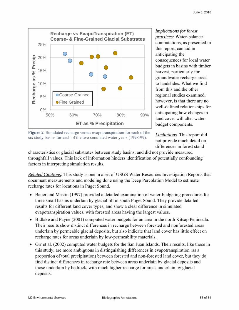
Implications for forest practices: Water-balance computations, as presented in this report, can aid in anticipating the consequences for local water budgets in basins with timber harvest, particularly for groundwater recharge areas to landslides. What we find from this and the other regional studies examined, however, is that there are no well-defined relationships for anticipating how changes in land cover will alter water-budget components.
Limitations. This report did not provide much detail on differences in forest stand
characteristics or glacial substrates between study basins, and did not provide measured throughfall values. This lack of information hinders identification of potentially confounding factors in interpreting simulation results.
Related Citations: This study is one in a set of USGS Water Resources Investigation Reports that document measurements and modeling done using the Deep Percolation Model to estimate recharge rates for locations in Puget Sound.
• Bauer and Mastin (1997) provided a detailed examination of water-budgeting procedures for three small basins underlain by glacial till in south Puget Sound. They provide detailed results for different land cover types, and show a clear difference in simulated evapotranspiration values, with forested areas having the largest values.
• Bidlake and Payne (2001) computed water budgets for an area in the north Kitsap Peninsula. Their results show distinct differences in recharge between forested and nonforested areas underlain by permeable glacial deposits, but also indicate that land cover has little effect on recharge rates for areas underlain by low-permeability materials.
• Orr et al. (2002) computed water budgets for the San Juan Islands. Their results, like those in this study, are more ambiguous in distinguishing differences in evapotranspiration (as a proportion of total precipitation) between forested and non-forested land cover, but they do find distinct differences in recharge rate between areas underlain by glacial deposits and those underlain by bedrock, with much higher recharge for areas underlain by glacial deposits.
0%
5%
10%
15%
20%
25%
50% 60% 70% 80% 90%
Rec
har
ge
as %
Pre
cip
ET as % Precipitation
Recharge vs EvapoTranspiration (ET)Coarse- & Fine-Grained Glacial Substrates
Coarse Grained
Fine Grained
Figure 2. Simulated recharge versus evapotranspiration for each of the six study basins for each of the two simulated water years (1998-99).
June 8, 2016
M2 Environmental Services Bibliographic Annotations 53 of 54

References
Bauer, H. H., and Mastin, M. C., 1997, Recharge from precipitation in three small glacial-till-mantled catchments in the Puget Sound lowland, Washington: U.S. Geological Survey.
Bauer, H. H., and Vaccaro, J., 1987, Documentation of a deep percolation model for estimating ground-water recharge: US Geological Survey, 2331-1258.
Bidlake, W. R., and Payne, K. L., 2001, Estimating recharge to ground water from precipitation at Naval Submarine Base Bangor and vicinity, Kitsap County, Washington, 2001-4110.
Orr, L. A., Bauer, H. H., and Wayenberg, J. A., 2002, Estimates of ground-water recharge from precipitation to glacial-deposit and bedrock aquifers on Lopez, San Juan, Orcas, and Shaw islands, San Juan County, Washington: US Geological Survey.
June 8, 2016
M2 Environmental Services Bibliographic Annotations 54 of 54

June 8, 2016
Citation
Cited in
Synthesis Cit
ed
in A
nn
ota
tio
n
Wat
er
Bal
ance
(Eva
po
tran
spir
atio
n, t
hro
ugh
fall,
tran
spir
atio
n, r
un
off
, re
char
ge)
Satu
rate
d/u
nsa
tura
ted
flo
w
(gro
un
dw
ate
r re
spo
nse
)
Ge
ote
chn
ical
Stu
dy/
Re
vie
w
Lan
dsl
ide
Cas
e S
tud
y (i
ncl
ud
ing
inve
nto
rie
s, r
evi
ew
s)
Co
up
led
Mo
de
l / G
IS m
od
el
Re
mo
te S
en
sin
g -
Map
pin
g/G
eo
ph
ysic
al t
ech
niq
ue
s
Ru
no
ut
Ty
pe
La
nd
sli
de
Stu
dy
Be
dro
ck
Gla
cia
l
To
La
nd
sli
de
Ge
ne
ral
Gro
un
d w
ate
r P
roc
es
se
s
Ev
ap
o t
ran
sp
ira
tio
n
Pre
cip
-Gro
un
dw
ate
r
Gro
un
dw
ate
r-L
an
ds
lid
e
Ra
infa
ll-L
an
ds
lid
e
Em
pir
ica
l
Mo
de
llin
g
Lo
ca
tio
n
KeyWords Main Points Relevance to Glacial Deep Seated Landslides Relevance to Forest Practices
Allstadt, K., Vidale, J. E., and Frankel, A. D., 2013, A scenario study of seismically induced landsliding in Seattle using broadband synthetic seismograms: Bulletin of the Seismological Society of America, v. 103, no. 6.
Indirect Peer-reviewed journal article
Yes No Yes NA NA NA NA NA NA NA NA Yes Seattle seismic, case study , landslide activation, hazard map
• Used synthetic seismograms to assess regional seismically induced landslide hazard in Seattle.• Compared predictions from landslides observed during Nisqually quake. • Earthquakes have potential to cause widespread landslide damage in Seattle.
Focused on shallow landslides and did not address deep-seated landsliding or liquefaction-related ground failure.
NA
Baldocchi, D. D., and Ryu, Y., 2011, A synthesis of forest evaporation fluxes - from days to years - as measured with eddy covariance, in Levia, D. F., Carlyle-Moses, D., and Tanaka, T., eds., Forest Hydrology and Biogeochemistry, Springer.
13.1 Jassal et al., 2009 Indirect Peer-reviewed journal article
No NA NA NA NA NA Yes No No No Yes No World wide Evapotranspiration, eddy covariance
• Provides a description of the eddy covariance technique.• Compilation of measured evapotranspiration fluxes from forests world side.• Annual evapotranspiration increases with increasing annual precipitation, but at less than half the rate of increase
Constrains range of potential evapotranspiration from forests, and thereby potential range of reductions in recharge associated with forests.
Constrains range of potential evapotranspiration from forests, and thereby potential range of increase in recharge associated with harvest of forests.
Batelaan, O., and F. De Smedt (2007), GIS-based recharge estimation by coupling surface–subsurface water balances, Journal of Hydrology, 337(3-4), 337-355.
Batallan & De Smedt, 2007, Miller & Sias, 1998
Indirect Water balance
Peer-reviewed journal article
NA NA NA NA Yes YES YES Yes No No NO YES Belgium recharge, coupled model, water balance
• Coupled soil-moisture water balance and saturated flow groundwater models to estimate spatially and temporally variable recharge and water table levels.
• It is feasible to apply such coupled models to estimate pore-pressure fields for stability assessments, as Miller and Sias (1998) did for the Hazel landslide and Brien and Reid (2008) did for deep-seated landslides in Seattle.
• To assess effects of forest practices on slope stability, such coupled models need to account for temporally and spatially variable vegetation cover, as done with the modeling in this study.• The question remains, however, if such coupled models are practical for assessing forest practices at a production level. Data requirements for these models include information on subsurface stratigraphy, which generally requires borehole data.
Bauer, H. H., and M. C. Mastin, (1997). Recharge from Precipitation in Three Small Glacial-Till-Mantled Catchments in the Puget Sound Lowland, Washington, US Geological Survey, Water Resources Investigations Report 96-4219. 72p
5.12, 13.2, 13.3; Q2)
Bauer & Mastin, 1997, Link, Unsworth & Marks, 2004, Orr, Bauer, and Wayenberg, 2002, Pypker, et al., 2005, Sumioka & Bauer, 2004
Indirect USGS Report NO NA Till NA YES NA YES Yes No No YES YES South lowland Puget Sound (Pierce County)
Evapotranspiration, interception loss, recharge, water budget
• Groundwater recharge rates are governed primarily by infiltration capacity of below-soil substrate.• Evapotranspiration varies systematically with vegatation cover, and is greatest for conifer and mixed forests.
The effects of land cover on soil moisture levels and water table elevations depend not only on evapotranspiration rates, but also on the substrates underneath. See also Bidlake and Payne (2001)
A clear-cut over till will atler runoff rates, but may have little effect on groundwater recharge (unless the runoff flows onto a permeable substrate). To assess the effects of timber harvest on water-budget components, we need to examine the subsurface flow paths. See also Bidlake and Payne (2001)
Baum, R. L., Coe, J. A., Godt, J. W., Harp, E. L., Reid, M. E., Savage, W. Z., Schulz, W. H., Brien, D. L., Chleborad, A. F., and McKenna, J. P., 2005, Regional landslide-hazard assessment for Seattle, Washington, USA: Landslides, v. 2, no. 4, p. 266-279.
Glacial Peer-reviewed journal article
YES NO YES NO NO NO NO No No No YES YES Seattle landslide processes • Review of geology, landslide mapping, and preliminary models for landslide hazard.• Work reported on in this paper is further described in the 2008 GSA publication Landslides and Engineering Geology of the Seattle, Washington, Area
• Brief review of landslide-prone stratigraphy of Puget Sound, but superceded by 2008 GSA publication.
Lots of information about geology, mass wasting processes, landslide types and locations. No particular insights for forest practices.
Berti, M. C., Alessandro, and Daehne, A., 2013, Comparative analysis of surface roughness algorithms for the identification of active landslides: Geomorphology, v. 182, p. 1-18.
LaHusen, et al., 2016 LiDAR Peer-reviewed journal article
Yes Yes No NA NA NA NA NA NA NA Yes Yes Italy, Residual clay-shale soils
LiDaR, surface roughness
• Compared several algorithms to evaluate surface roughness for identifying landslides• All methods reasonably accurate predictive maps for active slopes; simpler methods worked better than more complex methods.• Predictive accuracy of active non-forested slopes close to 90%; about 75% when including forested slopes, due to inherent roughness of densely vegetated areas incorrectly classified as "active slopes" by the roughness algorithms (false positives).
Promising for use of identification of large landslide features, even with larger resolution DEMs.
Predictive accuracy better in unforested slopes but authors are optimistic about potential for developing specific algorithms to overcome the negative effect of forest cover.
Gro
un
dw
ate
r R
ec
ha
rge
Glacial Deep Seated Landslide Literature Review
Lit
ho
log
y
Hydrology
Topic
Page 1 of 24
June 8, 2016
Citation
Cited in
Synthesis Cit
ed
in A
nn
ota
tio
n
Wat
er
Bal
ance
(Eva
po
tran
spir
atio
n, t
hro
ugh
fall,
tran
spir
atio
n, r
un
off
, re
char
ge)
Satu
rate
d/u
nsa
tura
ted
flo
w
(gro
un
dw
ate
r re
spo
nse
)
Ge
ote
chn
ical
Stu
dy/
Re
vie
w
Lan
dsl
ide
Cas
e S
tud
y (i
ncl
ud
ing
inve
nto
rie
s, r
evi
ew
s)
Co
up
led
Mo
de
l / G
IS m
od
el
Re
mo
te S
en
sin
g -
Map
pin
g/G
eo
ph
ysic
al t
ech
niq
ue
s
Ru
no
ut
Ty
pe
La
nd
sli
de
Stu
dy
Be
dro
ck
Gla
cia
l
To
La
nd
sli
de
Ge
ne
ral
Gro
un
d w
ate
r P
roc
es
se
s
Ev
ap
o t
ran
sp
ira
tio
n
Pre
cip
-Gro
un
dw
ate
r
Gro
un
dw
ate
r-L
an
ds
lid
e
Ra
infa
ll-L
an
ds
lid
e
Em
pir
ica
l
Mo
de
llin
g
Lo
ca
tio
n
KeyWords Main Points Relevance to Glacial Deep Seated Landslides Relevance to Forest Practices
Gro
un
dw
ate
r R
ec
ha
rge
Glacial Deep Seated Landslide Literature Review
Lit
ho
log
y
Hydrology
Topic
Berti, M., and Simoni, A., 2010, Field evidence of pore pressure diffusion in clayey soils prone to landsliding: Journal of Geophysical Research, v. 115, p. F03031.
5.8 Picarelli, Urciuoli and Russo, 2004
Indirect Peer-reviewed journal article
Yes NA NA NA NA YES NA Yes No No YES YES Italy, Residual clay-shale soils
Pressure wave, diffusivity
• 3-yr monitoring of high-frequency pore-pressure variations in shallow clayey soils overlying clay-shale bedrock• Soil saturated during rainfall response, with vertically propagating pressure waves that modulate with depth. Lateral flow model cannot replicate observations; no perched water table; water drains into bedrock. Bedrock is saturated, no event response. • Behavior represented by Iverson’s 2000 1-D (vertical) linear diffusion model• Predicted response extremely sensitive to material parameters (diffusivity), which are spatially heterogeneous • Time-scale and magnitude of event response from soil depth and diffusivity• Sensitive to material properties
Rainfall events create pressure waves through the saturated soil profile that attentuate with depth. At the slip surface of an existing landslide, variations in pressure control the balance of forces and determine when and how rapidly shear displacements occur. The timing and magnitude of landslide response to a time series of precipitation events thus depends on the depth to the slip surface and the diffusivity of the soil. The speed of pressure-wave propigation and the degree of attenuation are extremely sensitive to soil diffusivity, which is in general not well characterized. So it is feasible to develop models to predict landslide response, but with low certainty, because of uncertainties in landslide geometry and material property values of the soils composing the landslide deposit.
Important for trying to anticipate or model landslide responses.
Bidlake, W. R., and K. L. Payne, (2001). Estimating recharge to ground water from precipitation at Naval Submarine Base Bangor and vicinity, Kitsap County, Washington, US Geological Survey, Water-Resources Investigations Report 01-4110.
12, 13.2 Bidlake & Payne, 2001; Bauer & Mastin, 1997; Miller & Sias, 1998; Orr, Bauer, and Wayenberg, 2002; Orr, Bauer, and Wayenberg, 2002
Indirect USGS Report NO NA Till NO YES NA YES Yes No No YES YES Puget Sound Lowlands, North Kitsap Peninsula
groundwater recharge, evapotranspiration, interception loss
• Provide equations for recharge as a proportion of annual precipitation for different substrate and land-cover combinations.• Find that type of vegetation cover has little influence on recharge rates for fine-grained substrates, like glacial till.
The effects of land cover on soil moisture levels and water table elevations depend not only on evapotranspiration rates, but also on the substrates underneath. See also Bauer and Mastin (1997)
A clear-cut over till will alter runoff rates, but may have little effect on groundwater recharge (unless the runoff flows onto a permeable substrate). To assess the effects of timber harvest on water-budget components, we need to examine the subsurface flow paths. See also Bauer and Mastin (1997)
Bièvre, G., Kniess, U., Jongmans, D., Pathier, E. S., S., van Westen, C., Villemin, T., and Zumbo, V., 2011, Paleotopographic control of landslides in lacustrine deposits (Trièves plateau, Frence western Alps): Geomorphology, v. 125, p. 214-224.
Glacial Peer-reviewed journal article
Yes No
Lacu
strin
e de
posi
ts No No No No No No No Yes Yes French Alps, Quaternary glacial lacustrine clays
Bedrock topography • Two adjacent landslides with very different recent (50-yr) behavior.• Geophysical techniques used to estimate lacustrine deposit thickness variations.• The least active landslide is located in deposits buttressed on the downslope end by a bedrock ridge; the more active landslide has no such buttress. Hence, recent differences in landslide activity is thought to arise from differences in bedrock topography.
• Subsurface bedrock topography important control on landslide behavior
Important for trying to anticipate or model landslide responses.
Bogaard, T. A., and Greco, R., 2016, Landslide hydrology: from hydrology to pore pressure: Wiley Interdisciplinary Reviews: Water, v. 3, no. 3, p. 439-459.
5.1 Miller & Sias, 1998
Indirect
Peer-reviewed journal article
No No No No No Yes No No NO NO No No hydrology • Informative review of landslide hydrology.• Description of preferrential pathways.• Recommendations for research.
Useful information.
Bogaard, T., 2001, Analysis of hydrological processes in unstable clayey slopes [Doctor: Universiteit Utrecht.
Q1, Q6 Miller & Sias, 1998 Indirect Direct Direct Glacial Coupled hydro/stability
Ph.D Dissertation
Yes Yes No Yes NA Yes Yes Yes Yes Yes Yes Yes France, Residual soils from limestone
Coupled models, unsaturated zone, evapotranspiration
• Coupled 1-D unsaturated flow with 2D (vertical section) groundwater model• Groundwater fluctuations estimated for changes in climate and land use.• Groundwater fluctuations input to infinite slope and method of slices limit equilibrium and Bingham creep models.
• Nice review of processes• Groundwater response to rainfall depends on moisture content in unsaturated zone. Analyses examining vertical propagation of pressure waves (e.g., Iverson and Major, 1987; Berti and Simoni, 2010) dealt with soils saturated nearly to the ground surface; water storage and flux through the unsaturated zone has a profound influence on saturated-zone response to precipitation time series.• Creep of the landslide is responsive to changes in water table elevation. Creep rate variations depend on depth to shear zone, thickness of shear zone, and height of water table above shear zone.
• Groundwater response to forest practices modulated by depth of unsaturated zone.• Creep rate very responsive to water table elevation. • Cumulative displacement increases with time of elevated water table elevation.• Large displacements associated with long periods of elevated water table can lead to catastrophic failure (not discussed here, but Iverson, for example, discusses evolution of contraction response with amount of strain)
Page 2 of 24

June 8, 2016
Citation
Cited in
Synthesis Cit
ed
in A
nn
ota
tio
n
Wat
er
Bal
ance
(Eva
po
tran
spir
atio
n, t
hro
ugh
fall,
tran
spir
atio
n, r
un
off
, re
char
ge)
Satu
rate
d/u
nsa
tura
ted
flo
w
(gro
un
dw
ate
r re
spo
nse
)
Ge
ote
chn
ical
Stu
dy/
Re
vie
w
Lan
dsl
ide
Cas
e S
tud
y (i
ncl
ud
ing
inve
nto
rie
s, r
evi
ew
s)
Co
up
led
Mo
de
l / G
IS m
od
el
Re
mo
te S
en
sin
g -
Map
pin
g/G
eo
ph
ysic
al t
ech
niq
ue
s
Ru
no
ut
Ty
pe
La
nd
sli
de
Stu
dy
Be
dro
ck
Gla
cia
l
To
La
nd
sli
de
Ge
ne
ral
Gro
un
d w
ate
r P
roc
es
se
s
Ev
ap
o t
ran
sp
ira
tio
n
Pre
cip
-Gro
un
dw
ate
r
Gro
un
dw
ate
r-L
an
ds
lid
e
Ra
infa
ll-L
an
ds
lid
e
Em
pir
ica
l
Mo
de
llin
g
Lo
ca
tio
n
KeyWords Main Points Relevance to Glacial Deep Seated Landslides Relevance to Forest Practices
Gro
un
dw
ate
r R
ec
ha
rge
Glacial Deep Seated Landslide Literature Review
Lit
ho
log
y
Hydrology
Topic
Booth, A. M., Roering, J. J., and Perron, J. T., 2009, Automated landslide mapping using spectral analysis and high-resolution topographic data: Puget Sound lowlands, Washington, and Portland Hills, Oregon: Geomorphology.
8, Q7) LaHusen, et al., 2016 LiDAR Peer-reviewed journal article
Yes Yes Yes NA NA NA NA NA NA NA YES YES Puget Sound Lowlands, Portland Hills, Oregon
LiDaR, surface roughness, landslide dating, recurrence
• Used spectral analysis of LiDAR data to generate automated landslide maps• Identfied specific toporaphic signatures of deep-seated landslides• When calibratted by comparison with detailed, independently compiled landslide inventory maps, an average of 82% of terrain was correctly classified in the five study areas
Specifically focused on surface morphology of deep-seated landslides, both glacial and bedrock
Technique can be applied inexpensively and remotely to large areas - if LiDAR is available.
Bovis, M. J., and Jones, P., 1992, Holocene history of earthflow mass movements in south-central British Columbia: the influence of hydroclimatic changes: Canadian Journal of Earth Science, v. 29, p. 1746-1755.
6.5, 7.3 Bedrock Peer-reviewed journal article
Yes Yes No Yes NA NA NA No No No Yes NO Semi-arid interior of British Columbia
earthflow, cumulative precipitation
• Document temporal variations in regional earthflow movement rates that correlate with multiyear trends in cumulative precipitation over ~50-yr period of air-photo record• Tree-ring analysis collaborated historical trends, indicating increased earthflow movement during periods of high cumulative precipitation• Sediment cores from ephemeral lakes formed by gullies blocked by earthflows further indicate increased activity during wetter, cooler periods of glacial advances during the Holocene
Large earthflows respond to precipitation trends integrated over many years
Timber harvest increases groundwater recharge for a decade or more. Earthflows appear to respond to multiyear precipitation patterns. The increases to recharge from harvest are overprinted on multiyear variations in precipitation.
Bradbury, C. G., and Rushton, K. R., 1998, Estimating runoff-recharge in the Southern Lincolnshire Limestone catchment, UK: Journal of Hydrology, v. 211, p. 86-99.
7.12, 12.2 Indirect
Brien, D. L., and Reid, M. E., 2008, Assessing deep-seated landslide susceptibility using 3-D groundwater and slope-stability analyses, southwestern Seattle, Washington: Reviews in Engineering Geology, v. 20, p. 83-101. (Also Brien & Reid, 2007, USGS Scientific Investigations Report 2007-5092)
Q)7 Batallan & De Smedt, 2007; Miller & Sias, 1998; Savage et al., 2000
Coupled GW/ stability
Edited book chapter
Yes No
Gla
cial
dep
osit
stra
tigra
phy Yes NA No No No Yes No No Yes Seattle,
Duwamish HeadCoupled models, 3-D • Coupled 3-D groundwater model
(MODFLOW) and 3-D limit equilibrium model (SCOOPS) for coastal bluffs• Steady-state MODFLOW runs for 1) mean annual precip (calibration), 2) average rainy season precip, 3) maximum recorded four-month precip; recharge from Vaccaro et al. (1998) R = 0.838P-248 (mm). 2) and 3) used for stability analysis.• Calculated spatially distributed Fs for moderately large (3-30km3) and very large (30-300k m3) for both recharge scenarios.
• Illustrates types of data needed and results available from coupled models. • Applicable to new failures; not for activation of existing
Such a coupled-model approach could be used to assess potential influence of forest practices on slope stability. Data requirements may render this strategy impractical, but application to a set of idealized cases could provide a great deal of insight.
Brien, D. L., and Reid, M. E., 2007, Modeling 3-D Slope Stability of Coastal Bluffs, Using 3-D Ground-Water Flow, Southwestern Seattle, Washington: U.S. Geological Survey.
Miller & Sias, 1998 Coupled GW/ stability
USGS report Yes No Yes Yes NA No No No Yes No No Yes Seattle, Duwamish Head
Coupled models, 3-D
Page 3 of 24

June 8, 2016
Citation
Cited in
Synthesis Cit
ed
in A
nn
ota
tio
n
Wat
er
Bal
ance
(Eva
po
tran
spir
atio
n, t
hro
ugh
fall,
tran
spir
atio
n, r
un
off
, re
char
ge)
Satu
rate
d/u
nsa
tura
ted
flo
w
(gro
un
dw
ate
r re
spo
nse
)
Ge
ote
chn
ical
Stu
dy/
Re
vie
w
Lan
dsl
ide
Cas
e S
tud
y (i
ncl
ud
ing
inve
nto
rie
s, r
evi
ew
s)
Co
up
led
Mo
de
l / G
IS m
od
el
Re
mo
te S
en
sin
g -
Map
pin
g/G
eo
ph
ysic
al t
ech
niq
ue
s
Ru
no
ut
Ty
pe
La
nd
sli
de
Stu
dy
Be
dro
ck
Gla
cia
l
To
La
nd
sli
de
Ge
ne
ral
Gro
un
d w
ate
r P
roc
es
se
s
Ev
ap
o t
ran
sp
ira
tio
n
Pre
cip
-Gro
un
dw
ate
r
Gro
un
dw
ate
r-L
an
ds
lid
e
Ra
infa
ll-L
an
ds
lid
e
Em
pir
ica
l
Mo
de
llin
g
Lo
ca
tio
n
KeyWords Main Points Relevance to Glacial Deep Seated Landslides Relevance to Forest Practices
Gro
un
dw
ate
r R
ec
ha
rge
Glacial Deep Seated Landslide Literature Review
Lit
ho
log
y
Hydrology
Topic
Brümmer, C., Black, T. A., Jassal, R. S., Grant, N. J., Spittlehouse, D. L., Chen, B., Nesic, Z., Amiro, B. D., Arain, M. A., Barr, A. G., Bourque, C. P.-A., Coursolle, C., Dunne, A. L., Flanagan, L. B., Humphreys, E. R., Lafleur, P. M., Margolis, H. A., McCaughey, J. H., and Wofsy, S. C., 2012, How climate and vegetation type influence evapotranspiration and water use efficiency in Canadian forest, peatland and grassland ecosystems: Agricultural and Forest Meteorology, v. 153, p. 14-30.
5.11; 13.1 Jassal et al., 2009 Indirect Peer-reviewed journal article
No NA NA NA NA NA Yes No No No Yes NO Canada Evapotranspiration • Total annual evapotranspiration varies less than total annual precipitation across climatic zones; hence evapotranspiration varies as a proportion of annual precipitation is greater in areas with low annual precipiation and lower in areas with high annual precipitation.
• Helps constrain the range of annual precipitation available for recharge
• Helps constrain the range of increase in annual recharge that may occur with harvest
Burns, W. J., and Madin, I. P., 2009, Protocol for inventory mapping of landslide deposits from light detection and ranging (lidar) imagery: Oregon Department of Geology and Mineral Industries.
8 LaHusen, et al., 2016
LiDAR
DOGAMI publication
Yes NA NA NA NA NA NA NA NA NA NA NA NA LiDAR, inventory • Protocol for using LiDAR shaded relief imagery for landslide mapping
Buttle, J. M., 2011, The effects of forest harvesting on forest hydrology and biogeochemistry, in Levia, D. F., Carlyle-Moses, D., and Tanaka, T., eds., Forest Hydrology and Biogeochemistry: Synthesis of Past Research and Future Directions, Springer.
Hubbart, et al., 2007
Review
Chapter in book
No NA NA NA Yes Yes Yes Yes No No NA NA Worldwide - review
Precipitation, interception, evapotranspiration
Review article on effects of harvest on hydrology and biochemistry
Summarizes research on effects of forest practices on hydrology
Carey, J. M., and Petley, D. N., 2014, Progressive shear-surface development in cohesive materials; implications for landslide behaviour: Engineering Geology, v. 177, p. 54-65.
5.13, 6.8, 7.1 Indirect Peer-reviewed journal article
Yes Yes Yes No No No No No No No Yes No Experimental Progressive failure, brittle behavior
• Specialized triaxial cell tests used to better replicate stress conditions encountered in slopes. • Intact samples of Gault Clay exhibit brittle failure as pore pressures are increased under constant stress.• Pre-failure deformation is attributed to growth of microcracks throughout the sample.• Failure is attributed to coalescene of growing cracks.• Remolded samples exhibited ductile behavior.• Failure occurred under prolonged (>500 days)constant stress less than the peak strength exhibited in shorter-term tests at higher stress levels.
• Intact slopes in clay soils may undergo progressive failure, in which isolated zones within the slope fail over time. These zones may expand over time under constant stress. As failed zones expand, redistribution of load within the slope creates stress concentrations, which accelerates crack development. At some point, failed zones coalesce and the slope fails.• Time scale involved for natural slopes are unknown: centuries? Millenia?• The potential for progressive failure in dense clays, like overconsolidated glacial lacustrine deposits, indicates that stability analyses of intact slopes in these materials should assume residual strength.
No direct connection with forest practices, but for hazard assessment it may be important to realize that intact slopes may fail under residual-strength stress conditions, even if they have been standing apparently stably for thousands of years.
Page 4 of 24

June 8, 2016
Citation
Cited in
Synthesis Cit
ed
in A
nn
ota
tio
n
Wat
er
Bal
ance
(Eva
po
tran
spir
atio
n, t
hro
ugh
fall,
tran
spir
atio
n, r
un
off
, re
char
ge)
Satu
rate
d/u
nsa
tura
ted
flo
w
(gro
un
dw
ate
r re
spo
nse
)
Ge
ote
chn
ical
Stu
dy/
Re
vie
w
Lan
dsl
ide
Cas
e S
tud
y (i
ncl
ud
ing
inve
nto
rie
s, r
evi
ew
s)
Co
up
led
Mo
de
l / G
IS m
od
el
Re
mo
te S
en
sin
g -
Map
pin
g/G
eo
ph
ysic
al t
ech
niq
ue
s
Ru
no
ut
Ty
pe
La
nd
sli
de
Stu
dy
Be
dro
ck
Gla
cia
l
To
La
nd
sli
de
Ge
ne
ral
Gro
un
d w
ate
r P
roc
es
se
s
Ev
ap
o t
ran
sp
ira
tio
n
Pre
cip
-Gro
un
dw
ate
r
Gro
un
dw
ate
r-L
an
ds
lid
e
Ra
infa
ll-L
an
ds
lid
e
Em
pir
ica
l
Mo
de
llin
g
Lo
ca
tio
n
KeyWords Main Points Relevance to Glacial Deep Seated Landslides Relevance to Forest Practices
Gro
un
dw
ate
r R
ec
ha
rge
Glacial Deep Seated Landslide Literature Review
Lit
ho
log
y
Hydrology
Topic
Davies, O., Rouainia, M., Glendinning, S., Cash, M., and Trento, V., 2014, Investigation of a pore-pressure driven slope failure using a coupled hydro-mechanical model: Engineering Geology, v. 178, p. 70-81.
Miller & Sias, 1998 Glacial Coupled hydro/ stability
Peer-reviewed journal article
Yes No Yes Yes NA Yes Yes Yes Yes Yes Yes Yes Ireland, Quaternary glacial drift overlying bedrock.
Coupled models • Accelerated movement on existing failure surface. • Limit-equilibrium modeling indicated pore pressures as primary control on stability, but could not replicated observed behavior.• Coupled distributed hydrologic model (SHETRAN http://research.ncl.ac.uk/shetran) and finite difference continuum model FLAC (www.itascacg.com/software/flac) better replicated observed behavior, but could not replicate elevated pore pressures in lower slope• Accelerated movement attributed to increased pore pressures in lower slope associated with elevated river levels
• Poorly written paper• Primary take away – accelerated movement apparently triggered by increased river water level effects on within-slope pore pressures.
Hazard assessment must evaluate external controls on water table levels and pore pressures.
Dhakal, A. S., and Sidle, R. C., 2004, Pore water pressure assessment in a forest watershed: Simulations and distributed field measurements related to forest practices: Water Resources Research, v. 40.
Q1) Hotta et al., 2010 Indirect Peer-reviewed journal article
No NA NA NA
Yes
, Sha
llow
Yes
, Sha
llow No Yes No No Yes Yes Carnation Creek,
Vancouver Island, BC
Slope hydrology, shallow groundwater, harvest, road construction
• Array of 10 piezometers in shallow (~1m) colluvial soils on relatively steep slopes overlying bedrock and till. Monitoring 1-2yrs pre-harvest, 2-5yrs post harvest. • Increased peak pressure head response to rainstorms observed after road construction and harvest.• Change in response observed for moderate sized storms; little or no difference in response to large storms.• Areas with soil disturbance - resulting in potential loss of preferrential flow pathways - had a considerably larger response than areas with harvest alone.• Distributed hydrologic model successfully replicates general pattern of piezometer response, but did not include evapotranspiration changes.
This study focused more on shallow-landslide issues. However, increased shallow water table elevations in response to moderate storms indicate an increase in the porportion of rainfall during these storms available for recharge.
Changes in piezometer responses to storms pre- and post- road building and harvest indicate that forest practices increase the proportion of water that infiltrates the soil and/or increases water-table response for moderately sized rainstorms.
Dhakal, A. S., and Sullivan, K., 2014, Shallow groundwater response to rainfall on a forested headwater catchment in northern coastal California: implications of topography, rainfall, and throughfall intensities on peak pressure head generation: Hydrological Processes, v. 28, p. 446-463.
6.5, 13.1, 13.2 Indirect Peer-reviewed journal article
No NA NA NA
Yes
, Sha
llow
Yes
, Sha
llow No Yes No No Yes No Northern
CaliforniaSlope hydrology, shallow groundwater, throughfall
• Array of 83 piezometers in shallow (~1.2m) colluvial soils monitored for 3 yrs• Array of 27 throughfall collectors• All piezometers highly responsive to large mid-winter storms.• Peak pressure head response spatially variable and not correlated to topographic position.• Recession of pressure head strongly associated with topographic position
This study focused on shallow-landslide issues: shallow groundwater response to individual storms.
Average total throughfall over the catchment varied from 48% to 92% of rainfall over different time periods. Average throughfall was consistently 90% during wet periods with large storms.
Dieu, J. J., and Butt, G., 2004, Terrain Stability Assessment: Madrone Environmental Services.
3.2 Glacial Consulting report
Yes No Yes No No No No No No No Yes No Bogachiel River, Washington
Geomorphic interpretation
• Example of field observations, historical air-photo interpetation, and geomorphic interpretation to identify processes and timing of landslide development and assess likely influences of proposed forest practices on landslide activity. •One of few examples found using these traditional methods to assemble a compelling story that allowed the reader to assess for themselves the likely influence of forest practices.
Page 5 of 24

June 8, 2016
Citation
Cited in
Synthesis Cit
ed
in A
nn
ota
tio
n
Wat
er
Bal
ance
(Eva
po
tran
spir
atio
n, t
hro
ugh
fall,
tran
spir
atio
n, r
un
off
, re
char
ge)
Satu
rate
d/u
nsa
tura
ted
flo
w
(gro
un
dw
ate
r re
spo
nse
)
Ge
ote
chn
ical
Stu
dy/
Re
vie
w
Lan
dsl
ide
Cas
e S
tud
y (i
ncl
ud
ing
inve
nto
rie
s, r
evi
ew
s)
Co
up
led
Mo
de
l / G
IS m
od
el
Re
mo
te S
en
sin
g -
Map
pin
g/G
eo
ph
ysic
al t
ech
niq
ue
s
Ru
no
ut
Ty
pe
La
nd
sli
de
Stu
dy
Be
dro
ck
Gla
cia
l
To
La
nd
sli
de
Ge
ne
ral
Gro
un
d w
ate
r P
roc
es
se
s
Ev
ap
o t
ran
sp
ira
tio
n
Pre
cip
-Gro
un
dw
ate
r
Gro
un
dw
ate
r-L
an
ds
lid
e
Ra
infa
ll-L
an
ds
lid
e
Em
pir
ica
l
Mo
de
llin
g
Lo
ca
tio
n
KeyWords Main Points Relevance to Glacial Deep Seated Landslides Relevance to Forest Practices
Gro
un
dw
ate
r R
ec
ha
rge
Glacial Deep Seated Landslide Literature Review
Lit
ho
log
y
Hydrology
Topic
Dohnal, M., Černý, T., Votrubová, J., and Tesař, M., 2014, Rainfall interception and spatial variability of throughfall in spruce stand: Journal of Hydrology and Hydromechanics, v. 62, no. 4, p. 277-284.
13.1, 13.2 Indirect Peer-reviewed journal article
No NA NA NA NA NA Yes No No NO Yes No Czech Republic Inteception loss, throughfall
• Throughfall measured for 2 years at a 80-90-year-old spruce stand; mean annual precip = 863mm. This is a small plot (565 sq m), containing 27 trees. Five tipping-bucket rain gauges were used to collect throughfall measurements at different locations throughout the stand.• Throughfall varies with position within the stand and with each storm, but cumulative throughfall is consistent over annual time scales.• Interception loss determined as 36% of total precipitation for 2012, 33% for 2013.
Constrains range of potential interception loss from forests, and thereby potential range of reductions in recharge associated with forests.
Constrains range of potential interception loss from forests, and thereby potential range of increases in recharge associated with harvest.
Dragovich, J. D., and Brunengo, M. J., 1995, Landslide map of the Tilton River - Mineral Creek area, Lewis County, Washington: Washington Division of Geology and Earth Resources, Open File Report 95-1.
Inventory
DRN Open File report
Yes NA NA NA NA NA NA NA NA NA NA NA NA inventory • Data forms and tables for aerial photo mapped landslide inventory. • Data analyses reported in related articles in Washington Geology.
Dragovich, J. D., Brunengo, M. J., and Gerstel, W. J., 1993, Landslide Inventory and Analysis of the Tilton River - Mineral Creek Area, Lewis County, Washington. Part 1: Terrain and Geologic Factors: Washington Geology, v. 21, no. 3, p. 9-18.
Q7) Inventory Journal article Yes Yes Yes No No No No No No No Yes No South Cascades, Washington
Landslide inventory, aerial photo mapping
• Example of a landslide inventory compiled from aerial photo mapping and field validation. • Examination of assembly of landslide types, relative age classes, and associated topographic and geologic attributes.
Dragovich, J. D., Brunengo, M. J., and Gerstel, W. J., 1993, Landslide Inventory and Analysis of the Tilton River - Mineral Creek Area, Lewis County, Washington. Part 2: Soils, Harvest Age, and Conclusions: Washington Geology, v. 21, no. 4, p. 18-30.
Q7) Inventory Journal article Yes Yes Yes No No No No No No No Yes No South Cascades, Washington
Landslide inventory, aerial photo mapping
• Example of a landslide inventory compiled from aerial photo mapping and field validation. • Examination of assembly of landslide types, relative age classes, and associated topographic and geologic attributes.
This is a companion paper with Part 1 of Dragovich, Brunengo, and Gerstel, 1993.Analysis of the inventory data shows that glacial materials contain a high landslide density, relative to other substrates, and that density of shallow landslides is greater on existing, large, deep-seated landslide features.
These data document 1) higher shallow landslide densities associated with timber harvest and forest roads, and 2) higher density of shallow landslides on existing deep-seated landslide features. Hence, glacial deep-seated landslides may increase potential for shallow landsliding, which are sensitive to forest practices.
Eigenbrod, K., and Kaluza, D., 1999, Shallow slope failures in clays as a result of decreased evapotranspiration subsequent to forest clearing: Canadian geotechnical journal, v. 36, no. 1, p. 111-118.
Indirect Glacial Peer-reviewed journal article
Yes No
Gla
cial
lacu
strin
e No No No Yes (modeled)
Yes Yes Yes Yes Yes Ontario, glacial-lacustrine
Post harvest landslide • Shallow, translational failures in lacustrine clays occuring several years after deforestation. • Attributed to increased pore pressures associated with reduced ET, but not documented.
Shallow, perched water table responds to loss of forest cover, with consequent shallow, translational failure in lacustrine clay slopes
Simply documents formation of new landslide features associated with timber harvest. Local applicability is unknown.
Eilertsen, R. S., Hansen, L., Bargel, T. H., and Solberg, I., 2008, Clay slides in the Målselv valley, northern Norway: Characteristics, occurrence, and triggering mechanisms: Geomorphology, v. 93, p. 548-562.
Q5) Glacial Peer-reviewed journal article
Yes No
Gla
cial
mar
ine
and
lacu
strin
e No No No No No No No Yes No Norway, glacial-marine and marine clay
sensitive clay, geologic mapping, landslide inventory
• Detailed landslide inventory combined with detailed stratigraphy to explain the locations and types of landslide occurrences.• "Bottleneck" landslides associated with fluidization of failed material, common with sensitive clays. These landslide morphologies are similar to those at Gold Basin and Deforest Creek.
• Different styles of landsliding are associated with distinct stratigraphic and geomorphic relationships. • Detailed geologic mapping provides the key for explaining and anticipating landslide occurrences.
Suggests that detailed geologic mapping and reconstruction of depositional history may aid in interpreting spatial distribution of landslide types and in anticipating regional variations in landslide behavior.
Fletcher, L., O. Hungr, and S. Evans (2002), Contrasting failure behaviour of two large landslides in clay and silt, Canadian Geotechnical Journal , 39 (1), 46-62
4, 7.2, Q3), Q8) Fletcher, Hungr & Evans, 2002
Glacial Peer-reviewed journal article
YES NA
Lacu
strin
e NA NA NA NA No No No YES YES British Columbia Mobility, Soil properties • Controls on landslide mobility are basically unknown.• Soil texture may influence mobility.
We cannot (yet) predict which landslides will move incrementally and which will, at some point, fail catastrophically with long runout.
This lack of knowledge about potential runout length hinders our ability to assess downslope hazards.
Page 6 of 24

June 8, 2016
Citation
Cited in
Synthesis Cit
ed
in A
nn
ota
tio
n
Wat
er
Bal
ance
(Eva
po
tran
spir
atio
n, t
hro
ugh
fall,
tran
spir
atio
n, r
un
off
, re
char
ge)
Satu
rate
d/u
nsa
tura
ted
flo
w
(gro
un
dw
ate
r re
spo
nse
)
Ge
ote
chn
ical
Stu
dy/
Re
vie
w
Lan
dsl
ide
Cas
e S
tud
y (i
ncl
ud
ing
inve
nto
rie
s, r
evi
ew
s)
Co
up
led
Mo
de
l / G
IS m
od
el
Re
mo
te S
en
sin
g -
Map
pin
g/G
eo
ph
ysic
al t
ech
niq
ue
s
Ru
no
ut
Ty
pe
La
nd
sli
de
Stu
dy
Be
dro
ck
Gla
cia
l
To
La
nd
sli
de
Ge
ne
ral
Gro
un
d w
ate
r P
roc
es
se
s
Ev
ap
o t
ran
sp
ira
tio
n
Pre
cip
-Gro
un
dw
ate
r
Gro
un
dw
ate
r-L
an
ds
lid
e
Ra
infa
ll-L
an
ds
lid
e
Em
pir
ica
l
Mo
de
llin
g
Lo
ca
tio
n
KeyWords Main Points Relevance to Glacial Deep Seated Landslides Relevance to Forest Practices
Gro
un
dw
ate
r R
ec
ha
rge
Glacial Deep Seated Landslide Literature Review
Lit
ho
log
y
Hydrology
Topic
Floris, M., and Bozzano, F., 2008, Evaluation of landslide reactivation: A modified rainfall threshold model based on historical records of rainfall and landslides: Geomorphology, v. 94, no. 1–2, p. 40-57.
6.5, 6.7 Bedrock Peer-reviewed journal article
Yes Yes No No No Yes No Yes Yes Yes Yes No Italy rainfall threshold, landslide activation
• Rainfall patterns for 180 days preceeding initiation of motion (re-activation) on two intermittently moving, large landslides were examined.• Rainfall thresholds were identified: 150mm over 15 days in one case, 180mm over 15 days in the other, but reactivation may occur as much as two months after the event, and not all rainfall events exceedingt the threshold trigger landslides.• Monitoring at three piezometers, two at 14m and one at 11m depth, over ~ four years showed pressure-head response to extened periods of rain, with no response to short, intense events.
• Landslide activation occurs in response to temporal patterns of rainfall over days to months; with multiyear anticedent conditions possibly playing a role. • Although rainfall amounts were identified below which landslide activation was not observed (e.g., 180mm over 15 days), these events occurred as much as two months prior to activation, and other similar and larger events caused no response. "Threshold conditions appear to be related to rainfall over very long periods (one year/multiple years) rather than to a single precipitation episode"
Large landslides respond to rainfall patterns integrated over mult-year time scales; a long period of moderate rainfall can prime a landslide to respond to a large event (e.g., 180mm over 15 days). Loss of evapotranspiration associated with forest harvest increases effective precipitation, potentially increasing the potential of landslide activation.
Froese, C. R., and Cruden, D. M., 2001, Landslides in weakly cemented glaciolacustrine sediments, Morkill River valley, British Columbia: Canadian Geotechnical Journal, v. 38, p. 889-900.
Glacial Peer-reviewed journal article
Yes No
Gla
cial
lacu
strin
e No No No No No No No Yes No Canadian Rockies (west of Jasper)
Shallow landsliding Failure of shallow soils on steep slopes attributed to frost action and leaching of calcium cement
Limited applicability to GDSLS
Gash, J. H. C., 1979, An anlytical model of rainfall interception by forests: Quarterly Journal of the Royal Meteorological Society, v. 105, no. 443, p. 43-55.
Indirect Peer-reviewed journal article
No NA NA No No No Yes No NO No No Yes Theory, applied in England, but applicable world wide
interception loss Derivation of a widely used model for interception loss that accounts for canopy storage capacity, storm intensity, storm duration, intervals between storms, evaporation during storms, and evaporation between storms.
Soil-moisture water-balance models may be used to estimate vegetation influences on recharge to groundwater.
Interception loss is the dominant component of evapotranspiration from conifer forests; many soil-moisture water balance models use aspects of this model.
Geertsema, M., and Schwab, J. W., 2006, Challenges with terrain stability mapping in northern British Columbia: Streamline Watershed Management Bulletin, v. 10, no. 1, p. 18-26.
6.9, 7.2, 7.3, Q8) Glacial Journal article Yes Yes Yes No No No No No No No Yes No Northern British Columbia
landslide hazard • Overview of hazards posed by large, catastrophic landslides in British Columbia, and discussion of why terrain-mapping methods may miss these hazards.• Examples of long-runout flows generated in valley-filling tills.• Example of large landslide triggered in low-gradient till by rock fall from above.
Glacial deep-seated landslides can trigger extremely mobile flows, that pose hazards far downslope.
Hazard assessments need to look far up and down slope.
Geertsema, M., Clague, J. J., Schwab, J. W., and Evans, S. G., 2006, An overview of recent large catastrophic landslides in northern British Columbia, Canada: Engineering Geology, v. 83, p. 120-143.
6.3, Q3), Q5), Q8)
Glacial Peer-reviewed journal article
Yes Yes Yes No No NO No No No No Yes No Northern BC High mobility • Document occurrence of 38 large (5*10^5m3) mobile landslides in northern BC, including: Two in glacial marine sediments.Six in glacial lacustrine sediments.Ten in till or colluvium. • Note apparent increase in frequency of large landslides.
Documented historic occurrence of large, river-damming landslides in glacial sediments.
Warning against complacency - not that Oso didn't already do that. Big, mobile landslides do occur in deep glacial sediments.
Gerstel, W. J., Brunengo, M. J., Lingley, W. S., Logan, R. L., Shipman, H., and Walsh, T. J., 1997, Puget Sound bluffs: the where, why, and when of landslides following the holiday 1996-97 storms: Washington Geology, v. 25, no. 1, p. 17-31.
6.9, 7 Glacial Journal article Yes No Yes No No No No No No No Yes No Seattle, WA Field examples Descriptions, with many photos, of landslides in the Seattle area associated with storms during the 1996-97 winter
NA
Gerstel, W., 1996, The upside of the landslides of February 1996 - validating a stability analysis of the Capitol Campus bluffs, Olympia, Washington: Washington Geology, v. 24, no. 3, p. 3-16.
6.9, 12 Glacial Journal article Yes No Yes NA NA NA NA No No No Yes Yes Olympia, WA Field examples • Description of landslide features and hetrogeneous stratigraphy of bluffs exposing proglacial deposits, including fine-grained materials.• Mass wasting involves shallow, mostly colluvial material on steep slopes; evolution of failed material into small episodically moving earthflows in some cases.• Stability assessment using infinite slope and 2-D limit equilibrium; indicate low stability of colluvial mantle and potential for shallow failure into in-situ soils.
Description of landslide features and illustration of techniques for stability assessment
NA
Page 7 of 24

June 8, 2016
Citation
Cited in
Synthesis Cit
ed
in A
nn
ota
tio
n
Wat
er
Bal
ance
(Eva
po
tran
spir
atio
n, t
hro
ugh
fall,
tran
spir
atio
n, r
un
off
, re
char
ge)
Satu
rate
d/u
nsa
tura
ted
flo
w
(gro
un
dw
ate
r re
spo
nse
)
Ge
ote
chn
ical
Stu
dy/
Re
vie
w
Lan
dsl
ide
Cas
e S
tud
y (i
ncl
ud
ing
inve
nto
rie
s, r
evi
ew
s)
Co
up
led
Mo
de
l / G
IS m
od
el
Re
mo
te S
en
sin
g -
Map
pin
g/G
eo
ph
ysic
al t
ech
niq
ue
s
Ru
no
ut
Ty
pe
La
nd
sli
de
Stu
dy
Be
dro
ck
Gla
cia
l
To
La
nd
sli
de
Ge
ne
ral
Gro
un
d w
ate
r P
roc
es
se
s
Ev
ap
o t
ran
sp
ira
tio
n
Pre
cip
-Gro
un
dw
ate
r
Gro
un
dw
ate
r-L
an
ds
lid
e
Ra
infa
ll-L
an
ds
lid
e
Em
pir
ica
l
Mo
de
llin
g
Lo
ca
tio
n
KeyWords Main Points Relevance to Glacial Deep Seated Landslides Relevance to Forest Practices
Gro
un
dw
ate
r R
ec
ha
rge
Glacial Deep Seated Landslide Literature Review
Lit
ho
log
y
Hydrology
Topic
Gerstel, W., 2007, Geo/Hydro/Geomorphic Landslide Classification Project. CMER Scoping Document.
Q7) CMER scoping template
Yes No Yes No No No No No No No Yes No Washington Landslide inventory, classification This document lays out a strategy for devoping a
classification of glacial deep-seated landslides based on stratigraphic, hydrologic, topographic, and geomorphic settings and landslide types and morphology.
Such a classification would identify the range and types of landscape settings where glacial deep-seated landslides are found, and would provide a basis for selection of representative sites for field data collection and modeling studies.
Such a classification could provide the basis for a hazard screening tool, identifying those landscape settings where landslides tend to be more or less sensitive to forest practices.Gerstel, W., Heinitz, A., and Ikerd, K., 1999, Deep-seated Landslide Inventory of the West-Central Olympic Peninsula.
8, Q5) Inventory Landslide inventory
Yes Yes Yes No No No No No NO No Yes No Olympic Peninsula, Washington
Landslide inventory, aerial photo mapping
• Example of aerial-photo based landslide inventory with field verification. • Unfortunately, this inventory has not been digitized.
Landslide locations. Landslide locations.
Gertstel, W., 1996, Slope Stability Analysis of the Bluffs along the Washington State Capitol Campus, Olympia, Washington: Washington State Department of Natural Resources, Division of Geology and Earth Resources.
Glacial Report Yes No Yes No No No No No No No Yes Yes Olympia, WA Field examples Same material as Gerstel 1997, Washington Geology, but with greater detail
NA
Giraud, A., Antoine, P., Van Asch, T. W. J., and Nieuwenhuis, J. D., 1991, Geotechnical problems caused by glaciolacustrine clays in the French Alps: Engineering Geology, v. 31, p. 185-195.
7.2 Direct Peer-reviewed journal article
Yes No
Gla
cial
lacu
strin
e No No No No No No No Yes No French Alps, Quaternary glacial sediments
Geotechnical properities • Same location as Bièvre et al. (2011).• Varved glacial-lacustrine clays; composition and index properties reported• Describe three types of mass-wasting behavior in these clays:1) Surface movements (0-5m): relatively low plasticity indices (10-25) indicate rapid transformation from the plastic to liquid state with increasing moisture content and development of mudflows2) Planar sliding along slip surface parallel to slope (5-10m). Related to shrinkage cracks that allow direct penetration of water to silty beds. Intermittent movement in response to rain events.3) Deep-seated rotational (>10m). • Note plastic behavior of these clays means peak-strength measurements are not indicative of slope behavior
• Variety of mass-wasting mechanisms responding to different processes.• Peak-strength measurements poor indicator of slope behavior
Potentially useful general information on behavior of landslides in clay-rich soils for field interpretation.
Glenn, N. F., Streutker, D. R., Chadwich, D. J., Thackray, G. D., and Dorsch, S. J., 2006, Analysis of LiDAR-derived topographic information for characterizing and differentiating landslide morphology and activity: Geomorphology, v. 73, p. 131-148.
Q7) LaHusen, et al., 2016 LiDAR Peer-reviewed journal article
Yes Yes No No No No No No No No yes No southern Idaho LiDaR, surface roughness, landslide dating
• Use of LiDAR bare-earth DEM to compare morphologic attributes of two similar landslides, one recently active and one that failed in 1937.• Examined surface roughness, slope, semvariograms of slope, and fractal dimension.• Results distinguish differences between different landslide features (head, body, toe) and distinguish differences between the active and older landslide.• These methods require manual delineation of landslide features.
Indicate potential for use of LiDAR-based analysis to differentiate landslide features and relative ages.
Handwerger, A. L., Roering, J. J., and Schmidt, D. A., 2013, Controls on the seasonal deformation of slow-moving landslides: Earth and Planetary Science Letters, v. 377-378, p. 239-247.
Q7) SAR Peer-reviewed journal article
Yes Yes No No No No No No No No Yes Yes Northern California
remote sensing • Seasonal dynamics of 10 slow-moving landslides in same geologic and climatic environments reveal no difference in response time to rainfall, despite 5-fold difference in landslide depths. • This is in contrast to commonly applied 1-D diffusion model for pore pressure transmission
Observations counter to expectations suggest complications to basic conceptual model of pore-pressure diffusion with depth and landslide response.
Use DinSAR to determine rates and spatial patterns of large landslide movement.
Page 8 of 24
June 8, 2016
Citation
Cited in
Synthesis Cit
ed
in A
nn
ota
tio
n
Wat
er
Bal
ance
(Eva
po
tran
spir
atio
n, t
hro
ugh
fall,
tran
spir
atio
n, r
un
off
, re
char
ge)
Satu
rate
d/u
nsa
tura
ted
flo
w
(gro
un
dw
ate
r re
spo
nse
)
Ge
ote
chn
ical
Stu
dy/
Re
vie
w
Lan
dsl
ide
Cas
e S
tud
y (i
ncl
ud
ing
inve
nto
rie
s, r
evi
ew
s)
Co
up
led
Mo
de
l / G
IS m
od
el
Re
mo
te S
en
sin
g -
Map
pin
g/G
eo
ph
ysic
al t
ech
niq
ue
s
Ru
no
ut
Ty
pe
La
nd
sli
de
Stu
dy
Be
dro
ck
Gla
cia
l
To
La
nd
sli
de
Ge
ne
ral
Gro
un
d w
ate
r P
roc
es
se
s
Ev
ap
o t
ran
sp
ira
tio
n
Pre
cip
-Gro
un
dw
ate
r
Gro
un
dw
ate
r-L
an
ds
lid
e
Ra
infa
ll-L
an
ds
lid
e
Em
pir
ica
l
Mo
de
llin
g
Lo
ca
tio
n
KeyWords Main Points Relevance to Glacial Deep Seated Landslides Relevance to Forest Practices
Gro
un
dw
ate
r R
ec
ha
rge
Glacial Deep Seated Landslide Literature Review
Lit
ho
log
y
Hydrology
Topic
Handwerger, A. L., Roering, J. J., Schmidt, D. A., and Rempel, A. W., 2015, Kinematics of earthflows in the Northern California Coast Ranges using satellite interferometry: Geomorphology, v. 246, p. 321-333.
12
SAR
Peer-reviewed journal article
Yes Yes No No No No No No No No Yes Yes Northern California
SAR, remote sensing• Use of radar (InSAR) imagery time series to identify active landslides and to quantify rates and spatial variability in rates of movement.• Use of information derived from InSAR analyses with physical models of landslide rheology to infer landslide thickness.
Potential for use of SAR data for identifying active landslides and quantifying rates of displacement.
Hanell, C. R., 2011, Groundwater response to precipitation events, Kalaloch, Olympic Peninsula, Washington [Master of Science: Western Washington University, 116 p.
6.5 Indirect Indirect Thesis No Yes No No Yes Yes Yes Yes No No Yes Yes Olympic Peninsula, Washington
Pore pressure response, DHSVM
• Ten monitoring wells placed at three sites in shallow to moderatly deep soils (1.0 - 3.8m) overlying weathered sedimentary bedrock; one tipping-bucket rain gauge at each site for measures of throughfall; open-air precipitation based on somewhat distant (25km) weather station; monitoring over two years.• Throughfall estimated at 24%.• Rapid response (1-3 hours) to precipitation events at all sites.• DHSMV modeling indicates a 27.4% decrease in evapotranspiration with timber harvest.
Provides constraints on range of evapotranspiration reductions to potential groundwater recharge.
Provides constraints on range of evapotranspiration increases to potential groundwater recharge associated with timber harvest.
Haugerud, R. A., 2014, Preliminary Interpretation of Pre-2014 Landslide Deposits in the Vicinity of Oso, Washington: U.S. Geological Survey.
9.1 LaHusen, et al., 2016
LiDAR
USGS Report Yes No Yes No No No No No No No Yes No Stillaguamish River valley, Washington
LiDAR Example of landslide and deposit mapping from LiDAR shaded relief imagery.
Heller, P. L., 1981, Small landslide types and controls in glacial deposits: lower Skagit River drainage, northern Cascade Range, Washington: Environmental Geology, v. 3, p. 221-228.
Glacial Peer-reviewed journal article
Yes No Yes No No No No No No No Yes No Lower Skagit Valley, Wa
Inventory, aerial photo mapping
• Air photo (1956-1978) and field reconnaissance inventory of landslides in glacial deposits.• Of 167 mapped landslides, 77% were shallow failure types, 15% were classified as slump flows, and 8% were unclassified.• Correlation of proportion of landslide occurrences and presence or absence of clear-cut harvests showed now relationship with slump flows (although detection bias was not accounted for).
Example of an air-photo landslide inventory. Analysis methods have progressed since this study; results may differ if sources of bias are addressed.
Hoopes, O., and Hughes, J., 2014, In situ lateral stress measurement in glaciolacustrine Seattle clay using the pressuremeter: Journal of Geotechnical and Geoenvironmental Engineering, v. 140, no. 5.
6.8 Picarelli, Urciuoli and Russo, 2004
Indirect Peer-reviewed journal article
No No
Gla
cial
lacu
strin
e No No NO No No No No Yes No Seattle Material properties • Measure high in-situ K0 (ratio horizontal to vertical stress) in near surface, consistent with other studies.• High lateral stresses create stress concentrations at toe of cut slopes, which can cause progressive failure in stiff clays
Erosion into highly overconsolidated clays may result in stress concentrations and progressive slope failure.
Hotta, N., Tanaka, N., Sawano, S., Kuraji, K., Shiraki, D., and Suzuki, M., 2010, Changes in groundwater level dynamics after low-impact forest harvesting in steep, small watersheds: Journal of Hydrology, v. 385, p. 120-131.
6.5, Q1) Hotta et al., 2010 Indirect Peer-reviewed journal article
No Yes No No Shallow
Shallow
No Yes No No Yes No Japan Shallow groundwater, basin hydrology, paired watershed, harvest
• Paired basins with arrays of shallow observation wells monitored for 9 years, 5 preharvest, 4 post harvest.• Saturated soil conditions occurred more frequently post harvest• Depth of saturation increases post harvest• Post-harvest changes concentrated along areas of convergent flow.• Throughfall measured at 17% of total precipitation.
This study was focused on shallow groundwater response to harvest, but demonstrated that water-budget changes associated with harvest, specifically reduced interception loss, are manifest in macroscale changes in small basin response to rainstorms.
Harvest with minimum ground disturbance resulted in increased depth and areal extent of soil saturation
Page 9 of 24

June 8, 2016
Citation
Cited in
Synthesis Cit
ed
in A
nn
ota
tio
n
Wat
er
Bal
ance
(Eva
po
tran
spir
atio
n, t
hro
ugh
fall,
tran
spir
atio
n, r
un
off
, re
char
ge)
Satu
rate
d/u
nsa
tura
ted
flo
w
(gro
un
dw
ate
r re
spo
nse
)
Ge
ote
chn
ical
Stu
dy/
Re
vie
w
Lan
dsl
ide
Cas
e S
tud
y (i
ncl
ud
ing
inve
nto
rie
s, r
evi
ew
s)
Co
up
led
Mo
de
l / G
IS m
od
el
Re
mo
te S
en
sin
g -
Map
pin
g/G
eo
ph
ysic
al t
ech
niq
ue
s
Ru
no
ut
Ty
pe
La
nd
sli
de
Stu
dy
Be
dro
ck
Gla
cia
l
To
La
nd
sli
de
Ge
ne
ral
Gro
un
d w
ate
r P
roc
es
se
s
Ev
ap
o t
ran
sp
ira
tio
n
Pre
cip
-Gro
un
dw
ate
r
Gro
un
dw
ate
r-L
an
ds
lid
e
Ra
infa
ll-L
an
ds
lid
e
Em
pir
ica
l
Mo
de
llin
g
Lo
ca
tio
n
KeyWords Main Points Relevance to Glacial Deep Seated Landslides Relevance to Forest Practices
Gro
un
dw
ate
r R
ec
ha
rge
Glacial Deep Seated Landslide Literature Review
Lit
ho
log
y
Hydrology
Topic
Hubbart, J. A., Link, T. E., Gravelle, J. A., and Elliot, W. J., 2007, Timber harvest impacts on water yield in the continental/maritime hydroclimatic region of the United States: Forest Science, v. 53, no. 2, p. 169-180.
13.2 Hubbart et al, 2007 Indirect Peer-reviewed journal article
No Yes No No Yes Yes Yes No No No Yes No Northern Idaho Water yield, harvest • Paired watershed study of forest-practice influences on water yield.• Road construction increased water yield: added road area of 1.4% of basin area associated with 4.8% increase in yield in one case; added road area of 1% associated with 3.4% increase in the other.• Clear-cut harvest associated with increased water yield indicating reduction in evapotranspiration over harvest area of 30% of mean annual precipitation.• Partial-cut harvest (50% basal area) associated with increased water yield indicating reduction in evapotranspiration over harvest area of 28.5%.
Constrains forest-practice effects on evapotranspiration and potential increases in recharge.
Hungr, O., Corominas, J., and Eherhardt, E., 2005, Estimating landslide motion mechanism, travel distance and velocity, in Hungr, O., Fell, R., Couture, R., and Eberhardt, E., eds., Landslide Risk Management: London, Taylor & Francis Group.
7.1, 7.2, 9.1, 9.3 Fletcher, Hungr & Evans, 2002; Hunter & Fell, 2003;
Direct
Peer-reviewed journal article
Yes Yes Yes No No No No No No No Yes Yes World Wide Runout • Review of physical mechanisms controlling landslide runout.• Description of available methods for estimating runout.
Options for estimating runout for hazard assessment.
Hungr, O., Leroueil, S., and Picarelli, L., 2014, The Varnes classification of landslide types, an update: Landslides, v. 11, p. 167-194.
Fletcher, Hungr & Evans, 2002
Peer-reviewed journal article
No NA NA NA NA NA NA NA NA NA NA NA NA landslide, terminology Review article suggesting refinements to Varnes landslide classification,
Hunter, G., and Fell, R., 2003, Travel distance angle for "rapid" landslides in constructed and natural soil slopes: Canadian Geotechnical Journal, v. 40, p. 1123-1141.
9.2 Hunter & Fell, 2003
Direct
Peer-reviewed journal article
Yes Yes Yes No No No No No No No Yes Yes World Wide Runout • Review of data on landslide runout extent from landslides worldwide.• Provide empirical equations for estimates of runout length based on elevation drop, landslide volume, and receiving slope angle.
Options for estimating runout for hazard assessment.
Iverson, R. M., 2000, Acute Sensitivity of Landslide Rates to Initial Soil Porosity: Science, v. 290, no. 5491, p. 513-516.
Indirect Peer-reviewed journal article
Yes NA NA No No No No No No No Yes No Experimental Dilative soils, contractive soils
• Debris-flow flume experiments examining mobility of debris as function of porosity.• Wet, sandy soil with porosity ~0.5 contracted during failure, rapidly accelerated to speeds exceeding 1m/sec.• Soils with porosity of ~0.4 dilated upon failure and slipped episodically at rates averaging 0.002m/sec.
Glacial deep-seated landslides often contain wet, sandy, porous soils. However, these landslides primarily involve failure in overconsolidated, fine-grained soils with relatively low porosity that generally dilate upon failure. However, occurrence of very rapid, extremely mobile landslides in glacial sediments suggests potential for conditions to develop underwhich soils may contract in deformation. This topic is not resolved.
Unsure how to incorporate this information into hazard assessment.
Page 10 of 24

June 8, 2016
Citation
Cited in
Synthesis Cit
ed
in A
nn
ota
tio
n
Wat
er
Bal
ance
(Eva
po
tran
spir
atio
n, t
hro
ugh
fall,
tran
spir
atio
n, r
un
off
, re
char
ge)
Satu
rate
d/u
nsa
tura
ted
flo
w
(gro
un
dw
ate
r re
spo
nse
)
Ge
ote
chn
ical
Stu
dy/
Re
vie
w
Lan
dsl
ide
Cas
e S
tud
y (i
ncl
ud
ing
inve
nto
rie
s, r
evi
ew
s)
Co
up
led
Mo
de
l / G
IS m
od
el
Re
mo
te S
en
sin
g -
Map
pin
g/G
eo
ph
ysic
al t
ech
niq
ue
s
Ru
no
ut
Ty
pe
La
nd
sli
de
Stu
dy
Be
dro
ck
Gla
cia
l
To
La
nd
sli
de
Ge
ne
ral
Gro
un
d w
ate
r P
roc
es
se
s
Ev
ap
o t
ran
sp
ira
tio
n
Pre
cip
-Gro
un
dw
ate
r
Gro
un
dw
ate
r-L
an
ds
lid
e
Ra
infa
ll-L
an
ds
lid
e
Em
pir
ica
l
Mo
de
llin
g
Lo
ca
tio
n
KeyWords Main Points Relevance to Glacial Deep Seated Landslides Relevance to Forest Practices
Gro
un
dw
ate
r R
ec
ha
rge
Glacial Deep Seated Landslide Literature Review
Lit
ho
log
y
Hydrology
Topic
Iverson, R. M., 2000, Landslide triggering by rain infiltration: Water Resources Research, v. 36, no. 7, p. 1897-1910.
5.8, 12 Direct Peer-reviewed journal article
Yes Yes No Yes Yes Yes No Yes Yes No No Yes Theory Pore pressure response, Diffusivity, Time scale
• Pore-pressure responses to rainfall occur over two primary time scales: that for transient propagation of pressure fluctuations from rainfall through the soil column and that for development of steady background pressures in response to time-averaged rainfall over the contributing (recharge) area.• Background pressures influence propensity for landsliding; landsliding is triggered by transient responses.• Reduced forms of the Richards equation provide estimates of these time scales in terms of soil depth, contributing area dimensions, and soil diffusivity.• Example calculations for steep, shallow, high-diffusivity soils in western Oregon yield transient response time for pressure propagation through the soil column of 20 minutes and a steady response time of 1 day. Calculations for the low-diffusivity soils of the Minor Creek landslide in northern California indicate a transient response time of 1 year and a steady response of 300 years.• Modeled pressure fluctiotions were applied with an infinite slope model for stability, illustrating rapid failure response for shallow failures in permeable soils; gradual response for deeper landslides in fine-grained, low-diffusivity soils.
The approximations used apply to situations where soil depth is very small compared to the length scale of the area contributing groundwater flow. Iverson's approach has been incorporated into a model for prediction of shallow landsliding (TRIGS). These concepts could be applied to gain insight for pore-pressure response times of situations typical of glacial deep-seated landslides.
Iverson, R. M., 2005, Regulation of landslide motion by dilatancy and pore pressure feedback: Journal of Geophysical Research, v. 110, p. F02015.
5.15, Q 3) Indirect Peer-reviewed journal article
Yes NA NA NA NA NA NA No No No NA Yes Theory Mobility, Soil properties • Soils may increase (dilate) or decrease (contract) in volume during shear. If saturated, dilation causes a drop in pore pressure and contraction causes an increase.• This shear-associated change in pore pressure will dissipate at a rate dependent on the diffusivity of the soil. • Feedback due to coupling between landslide motion, shear-zone volume change, and pore-pressure change dictates landslide motion. • If shear-zone soil contracts during landslide motion, runaway acceleration will occur.
Landslide behavior may depend on properties of soils in the shear zone that determine dilatancy or contraction. See also Iverson et al. 2000, and Iverson et al. 2015 and 2016
As far as we can tell, any deep-seated landslide deposit is subject to runaway acceleration at some point. This is an important factor in assessing downslope hazards posed by deep seated landslides.
Iverson, R. M., and George, D. L., 2016, Modelling landslide liquefaction, mobility bifurcation and the dynamics of the 2014 Oso disaster: Géotechnique, v. 66, no. 3, p. 175-187.
9.3 Indirect Peer-reviewed journal article
Yes No Yes No No No No No No No No Yes SR530 landslide, Stillaguamish Valley, Washington
High mobility • Detailed description of D-Claw, for motion of fluid-filled granular mixtures• High mobility of the Oso landslide is attributed to liquefaction of water-saturated sediment at its base.• Simulations for multiple scenarios of material properties for Oso indicate large sensitivity to initial conditions.• High mobility of the Oso landslide is attributed to liquefaction of water-saturated sediment at its base.
Application of physical models to elucidate potential mechanism for high mobility may aid in determining why some landslides behave one way and others behave differently, or why a landslide behaves one way for many years, and then suddenly exhibits different behavior.
Unsure
Page 11 of 24

June 8, 2016
Citation
Cited in
Synthesis Cit
ed
in A
nn
ota
tio
n
Wat
er
Bal
ance
(Eva
po
tran
spir
atio
n, t
hro
ugh
fall,
tran
spir
atio
n, r
un
off
, re
char
ge)
Satu
rate
d/u
nsa
tura
ted
flo
w
(gro
un
dw
ate
r re
spo
nse
)
Ge
ote
chn
ical
Stu
dy/
Re
vie
w
Lan
dsl
ide
Cas
e S
tud
y (i
ncl
ud
ing
inve
nto
rie
s, r
evi
ew
s)
Co
up
led
Mo
de
l / G
IS m
od
el
Re
mo
te S
en
sin
g -
Map
pin
g/G
eo
ph
ysic
al t
ech
niq
ue
s
Ru
no
ut
Ty
pe
La
nd
sli
de
Stu
dy
Be
dro
ck
Gla
cia
l
To
La
nd
sli
de
Ge
ne
ral
Gro
un
d w
ate
r P
roc
es
se
s
Ev
ap
o t
ran
sp
ira
tio
n
Pre
cip
-Gro
un
dw
ate
r
Gro
un
dw
ate
r-L
an
ds
lid
e
Ra
infa
ll-L
an
ds
lid
e
Em
pir
ica
l
Mo
de
llin
g
Lo
ca
tio
n
KeyWords Main Points Relevance to Glacial Deep Seated Landslides Relevance to Forest Practices
Gro
un
dw
ate
r R
ec
ha
rge
Glacial Deep Seated Landslide Literature Review
Lit
ho
log
y
Hydrology
Topic
Iverson, R. M., and Major, J. J., 1987, Rainfall, ground-water flow, and seasonal movement at Minor Creek landslide, northwestern California: Physical interpretation of empirical relations: Geological Society of America Bulletin, v. 99, p. 579-594.
5.14, 6.4, Q1) Bedrock Peer-reviewed journal article
Yes Yes No No No Yes No Yes Yes Yes Yes Yes Northern California
earthflow, pore pressure response
• For saturation to (or near to) the surface, rainfall events trigger a pore-pressure wave that propagates vertically at a speed dependent on diffusivity of the soil and that attenuates with depth.• Below a depth of about 5m, short-period (event) fluctuations disappear and pore pressures respond to longer-term (seasonal) infiltration.• Earthflow motion initiates at a threshold pore pressure near the base.
• For existing landslides with basal shear zones, movement initiates with a threshold basal pore pressure.• Pore-pressure response (and associate landslide movement) at depth lags precipitation events, and reflects precipitation patterns integrated over time scales dependent on soil properties and depth to the shear zone.
Groundwater response was to infiltration over the body of the landslide itself. Extrapolating the observation that major earthflow movement initiated with a threshold in pore pressure, multi-year increases in infiltration associated with harvest on existing, but currently stable, landslide deposits could potentially raise water table levels sufficiently to trigger renewed movement.
Iverson, R. M., George, D. L., Allstadt, K., Reid, M. E., Collins, B. D., Vallance, J. W., Schilling, S. P., Godt, J. W., Cannon, C. M., Magirl, C. S., Baum, R. L., Coe, J. A., Schulz, W. H., and Bower, J. B., 2015, Landslide mobility and hazards: implications of the 2014 Oso disaster: Earth and Planetary Science Letters, v. 412, p. 197-208.
7.2, Q3) Fletcher, Hungr & Evans, 2002
Indirect Peer-reviewed journal article
Yes No Yes No No No No No No No No Yes SR530 landslide, Stillaguamish Valley, Washington
High mobility • High mobility of the Oso landslide is attributed to liquefaction of water-saturated sediment at its base.• Liquifaction attributed to compression of saturated debris from previous landslide events by debris from failure of the slope above, and shear-induced compression.• Numerically modeling indicates that potential for liquifaction is extremely sensitivt to initial porosity of the water-saturated sediment.
The March 22, 2014 Oso landslide highlights the potential for highly mobile failure of glacial deep-seated landslides. This and other examples (e.g., Fletcher et al., 2003) show that these landslides can exhibit one mode of behavior characterized by periodic, blocky movements for many decades, perhaps centuries, and then for reasons so far unexplained develop into an extremely mobile flow.
Unsure
Jassal, R. S., Black, T. A., Spittlehouse, D. L., Bradford, M., Brümmer, C., and Nesic, Z., 2009, Evapotranspiration and water use efficiency in different-aged Pacific Northwest Douglas-fir stands: Agricultural and Forest Meteorology, v. 149, no. 6, p. 1168-1178.
13.1 Jassal et al., 2009 Direct Peer-reviewed journal article
No NA NA NA NA No Yes NO No NO Yes No Vancouver Island, British Columbia
Evapotranspiration, eddy covariance
• Multi-year eddy-covariance measurements of evapotranspiration for three forest stands, one 58 years old, another 19, and another 7 (all as of 2007). • Average annual evapotranspiration of the 19- and 58-year-old stands was 26.3% of annual precipitation; 18.3% for the 7-year-old stand: a 30% reduction.
Constrains reduction in recharge associated with forest land cover.
• Timber harvest at this site resulted in an increase of water available for recharge of 8% of annual precipitation. • Evapotranspiration recovered to pre-harvest levels in about 12 years.
Jibson, R. W., 1996, Use of landslides for paleoseismic analysis: Engineering Geology, v. 43, p. 291-323.
6.1 Peer-reviewed journal article
Yes Yes Yes No No No No No No No Yes No World Wide Earthquake Discusses factors for identifying earthquake-triggered landslides and determining their age.
Johnson, A. C., Edwards, R. T., and Erhardt, R., 2007, Ground-water response to forest harvest: implications for hillslope stability: Journal of the American Water Resources Association, v. 43, no. 1, p. 134-147.
6.5, Q1) Hotta et al., 2010 Indirect Peer-reviewed journal article
No Yes No NA
Shal
low
Shal
low No Yes No No Yes No Southeast Alaska shallow groundwater,
harvest• 7-well arrays monitored water table elevations in shallow soils in four bedrock hollows at two sites, for a total of eight monitored bedrock hollows. Monitored 1-2 years pre harvest, 2 years post harvest.• At each site, one control (no treatment), and harvest of 25%, 75%, and 100% basal area.• For a set of characteristic storms, one site showed statistically significant reductions in the rainfall depth required for peak and average levels of soil saturation for all treatments; the other site showed no significant change.• At the responsive site, there was a 22%, 29%, and 34% reduction in rainfall depth needed to saturate soils after 25%, 75%, and 100% harvest.
This study focused on shallow-landslide issues: shallow groundwater response to individual storms.
Hillslope hydrology was found to respond, in terms of depth of soil saturation, to harvest at one site, but not at another.
Page 12 of 24
June 8, 2016
Citation
Cited in
Synthesis Cit
ed
in A
nn
ota
tio
n
Wat
er
Bal
ance
(Eva
po
tran
spir
atio
n, t
hro
ugh
fall,
tran
spir
atio
n, r
un
off
, re
char
ge)
Satu
rate
d/u
nsa
tura
ted
flo
w
(gro
un
dw
ate
r re
spo
nse
)
Ge
ote
chn
ical
Stu
dy/
Re
vie
w
Lan
dsl
ide
Cas
e S
tud
y (i
ncl
ud
ing
inve
nto
rie
s, r
evi
ew
s)
Co
up
led
Mo
de
l / G
IS m
od
el
Re
mo
te S
en
sin
g -
Map
pin
g/G
eo
ph
ysic
al t
ech
niq
ue
s
Ru
no
ut
Ty
pe
La
nd
sli
de
Stu
dy
Be
dro
ck
Gla
cia
l
To
La
nd
sli
de
Ge
ne
ral
Gro
un
d w
ate
r P
roc
es
se
s
Ev
ap
o t
ran
sp
ira
tio
n
Pre
cip
-Gro
un
dw
ate
r
Gro
un
dw
ate
r-L
an
ds
lid
e
Ra
infa
ll-L
an
ds
lid
e
Em
pir
ica
l
Mo
de
llin
g
Lo
ca
tio
n
KeyWords Main Points Relevance to Glacial Deep Seated Landslides Relevance to Forest Practices
Gro
un
dw
ate
r R
ec
ha
rge
Glacial Deep Seated Landslide Literature Review
Lit
ho
log
y
Hydrology
Topic
Jongmans, D., Bièvre, G., Renalier, R., Schwartz, S., Beaurez, N., and Orengao, Y., 2009, Geophysical investigation of a large landslide in glaciolacustrine clays in the Trièves area (French Alps): Engineering Geology, v. 209, p. 45-56.
Geophysical
Peer-reviewed journal article
Yes No
Gla
cial
lacu
strin
e No No No No No No No No Yes French Alps, Quaternary glacial sediments
Geophysical techniques • Tested five geophysical techniques: seismic noise measurement, electrical tomography, P-wave refraction, S-wave refraction, and surface wave inversion).• Seismic noise: resonant frequency of surface layers, useful for estimating total deposit thicknesses.Electrical resistivity: may resolve water tableP-wave refraction: may resolve water tableS-wave velocity contrast most sensitive for estimating depth to slip surface
Options for landslide analysis and monitoring – cheaper than drilling
Jongmans, D., Kniess, U., Schwartz, S., Pathier, E. S., S., Orengo, Y., Bièvre, G., Villemin, T., and Delacourt, C., 2008, Characterization of the Avignonet landslide (French Alps) with seismic techniques, in Chen, Z., Zhang, J., Ho, K., Wu, F., and Li, Z., eds., Landslides and Engineered Slopes. From the Past to the Future: Xi'an, China, CRC Press.
Geophysical
Conference Proceedings, Paper
Yes No
Gla
cial
lacu
strin
e No No No No No No No No Yes French Alps, Quaternary glacial sediments
Geophysical techniques Reports on same work as Jongmans et al., 2009
Karlin, R. E., Holmes, M., Abella, S. E. B., and Sylwester, R., 2004, Holocene landslides and a 3500-year record of Pacific Northwest earthquakes from sediments in Lake Washington: Geological Society of America Bulletin, v. 116, no. 1, p. 94.
6.1 Peer-reviewed journal article
Yes No Yes No No No No No No No Yes No Lake Washington, Seattle, Washington
Earthquake trigger • Seismic reflection profiling, side-scan sonar, and coring used to determine distribution, geometry, age, and causes of submarine landslides in Lake Washington.• Lake Washington shows evidence of multiple, very large, earthquake-triggered landslides, the last associated with a 900-930AD major event.
Earthquakes may trigger large landslides. Lake Washington provided a setting where evidence of such landslides is well preserved.
Keaton, J. R., Wartman, J., Anderson, S. A., Benoît, J., deLaChapelle, J., Gilbert, R., and Montgomery, D. R., 2014, The 22 March 2014 Oso Landslide, Snohomish County, Washington: National Science Foundation.
7.2, Q8) LaHusen, et al., 2016 Glacial Report Yes No Yes No No No No No No NO Yes No SR530 landslide, Stillaguamish Valley, Washington
Field examples Report of field observations of the SR530 landslide.
SR530 is a glacial deep-seated landslide that obviously posed a substantial and unrecognized hazard. It serves as an example with which to learn how to recognize similar hazards. Debate continues on the mechanisms of failure and onset of extremely high mobility, but this landslide alerts us to the need to acknowledge the potential for highly mobile glacial deep-seated landsliding.
Unsure
Keppeler, E. T., Ziemer, R. R., and Cafferata, P. H., 1994, Changes in soil moisutre and pore pressure after harvesting a forested hillslope in northern California, Annual Summer Symposium of the American Water Resources Associatiation: Effects of Human-Induced Changes on Hydrologi Systems: Jackson Hole, Wyoming, American Water Resources Association, p. 205-214.
Q1) Indirect Conference Proceedings, Paper
No Yes No NA NA Yes No Yes No No Yes No Caspar Creek, Northern California
hillslope hydrology, shallow groundwater, paired basin
• 58-piezometer array of one bedrock hollow; discharge through pipe flow monitored at base of that and another hollow. Basin with piezometers clear-cut after 2 years; post harvest monitoring for 4 years. Results for 6 piezometers.• Peak piezometer water levels increased post harvest
This study focused on shallow-landslide issues: shallow groundwater response to individual storms.
Increased soil moisture and depth of saturation in response to storm events post harvest.
Kilburn, C. R. J., and Petley, D. N., 2003, Forecasting giant, catastrophic slope collapse: lessons from Vajont, Northern Italy: Geomorphology, v. 54, no. 1-2, p. 21-32.
6.8 Indirect Peer-reviewed journal article
Yes Yes No No No No No No No No Yes No French Alps Progressive failure • Bedrock failure, self-accelerating rock fracture• Discuss brittle behavior of clay• Slow deformation and accelerating creep precursor to collapse• Caveats for hazard assessments of intact slopes
Caveats for hazard assessments of intact slopes
Page 13 of 24
June 8, 2016
Citation
Cited in
Synthesis Cit
ed
in A
nn
ota
tio
n
Wat
er
Bal
ance
(Eva
po
tran
spir
atio
n, t
hro
ugh
fall,
tran
spir
atio
n, r
un
off
, re
char
ge)
Satu
rate
d/u
nsa
tura
ted
flo
w
(gro
un
dw
ate
r re
spo
nse
)
Ge
ote
chn
ical
Stu
dy/
Re
vie
w
Lan
dsl
ide
Cas
e S
tud
y (i
ncl
ud
ing
inve
nto
rie
s, r
evi
ew
s)
Co
up
led
Mo
de
l / G
IS m
od
el
Re
mo
te S
en
sin
g -
Map
pin
g/G
eo
ph
ysic
al t
ech
niq
ue
s
Ru
no
ut
Ty
pe
La
nd
sli
de
Stu
dy
Be
dro
ck
Gla
cia
l
To
La
nd
sli
de
Ge
ne
ral
Gro
un
d w
ate
r P
roc
es
se
s
Ev
ap
o t
ran
sp
ira
tio
n
Pre
cip
-Gro
un
dw
ate
r
Gro
un
dw
ate
r-L
an
ds
lid
e
Ra
infa
ll-L
an
ds
lid
e
Em
pir
ica
l
Mo
de
llin
g
Lo
ca
tio
n
KeyWords Main Points Relevance to Glacial Deep Seated Landslides Relevance to Forest Practices
Gro
un
dw
ate
r R
ec
ha
rge
Glacial Deep Seated Landslide Literature Review
Lit
ho
log
y
Hydrology
Topic
Kohv, M., Hang, T., Talviste, P., and Kalm, V., 2010, Analysis of a retrogressive landslide in glaciolacustrine varved clay: Engineering Geology, v. 116, p. 109-116.
6.4, Q5) Glacial Peer-reviewed journal article
Yes No
Gla
cial
lacu
strin
e No No No No No No No Yes Yes Italian Alps Retrogressive failure, confined aquifer
• Landslide in varved clays that are not highly overconsolidated.• Low relief (~6m).• Multiple boreholes and cross correlation of varves provides subsurface geometry and material for lab testing.• Retrogressive evolution indicated by limit-equilibruim modeling: initial rotational failure triggered by river bank erosion at meander; subsequent two failures extended further upslope, possibly in response to increasing pore pressures in confined aquifer in underlying till and high water levels in river, but also required slip surface developed with earlier failures.
• Existing landslide can increase potential for headward progression of further landsliding.• Potential importance of high pore pressures in confined aquifer underlying landslide deposit
• Hazard assessment needs to identify potential for retrogressive failure.• Landslides may respond to pore-pressures within underlying confined aquifers.
Kohv, M., Talviste, P., Hang, T., and Kalm, V., 2010, Retrogressive slope failure in glaciolacustrine clays: Sauga landslide, western Estonia: Geomorphology, v. 124, p. 229-237.
6.4, 6.8 Glacial Peer-reviewed journal article
Yes No
Gla
cial
lacu
strin
e No No No No No No No Yes Yes Estonia, glacial-lacustrine varved clays overlying till
Retrogressive failure, confined aquifer
Similar to Kohv et al. (2010) in Engineering Geology; different landslide, same story. Highlights:• Pore pressures in underlying confined aquifer likely play an important role, rather than infiltration of surface water.• Development of tension cracks prior to landslide formation indicate progressive failure in clay.• Monitoring indicates creep.
• Pore pressures in lower confined aquifer play role in landslide cause.• Retrogressive failure complex triggered by small failure associated with bank erosion by river at toe of slope.• Limit equilibrium modeling indicate residual strength, even for intact slopes – suggesting progressive failure.
• Hazard assessment needs to identify potential for retrogressive failure.• Retrogressive faiilure may occur due to weakening of intact soils and progressive failure.• Landslides may respond to pore-pressures within underlying confined aquifers.
Kohv, M., Talviste, P., Hang, T., Kalm, V., and Rosentau, A., 2009, Slope stability and landslides in proglacial varved clays of western Estonia: Geomorphology, v. 106, p. 315-323.
Glacial Peer-reviewed journal article
Yes No
Gla
cial
lacu
strin
e No No No No No No No Yes No Estonia, glacial-lacustrine varved clays overlying till
Landslide inventory, hazard map
Describes landslide types observed along river banks in glacial-lacustrine deposits overlying till with overlying marine sands. River bank erosion triggers small, rotational landslides in clay; subsequent retrogressive failures extend the landslide headward.Landslide hazard map based on minimum slope and presence of glacial-lacustrine deposits was made.
Hazard mapping based on slope, geology, and potential for human activities.
Example of hazard mapping (e.g., screening tool) for glacial deep-seated landslides.
LaHusen, S. R., A. R. Duvall, A. M. Booth, and D. R. Montgomery (2016), Surface roughness dating of long-runout landslides near Oso, Washington (USA), reveals persistent postglacial hillslope instability, Geology , 44 (2), 111-114
Q7) LaHusen, et al., 2016 LiDAR Peer-reviewed journal article
YES NA
Thic
k ou
twas
h,
lacu
strin
e NA NA NA NA No No No YES YES Stillaguamish River valley, Washington
LiDAR, surface roughness, landslide dating, recurrence
• LiDAR bare-earth DEM derived surface texture can be used to estimate relative age of landslide landforms.• Relative ages can be translated to absolute age with a few known landslide dates.
• Such techniques might be used to assess rates of landslide activity, and to differentiate inactive from active landslides.
These techniques might be employed in hazard assessment, if they can differentiate active from inactive landslides.
Legros, F., 2002, The mobility of long-runout landslides: Engineering Geology, v. 63, p. 301-331.
9.2 Hunter & Fell, 2003
Direct
Peer-reviewed journal article
Yes Yes Yes No No No No No No No Yes Yes World Wide Runout • Review of data on landslide runout extent from landslides worldwide.• Provides empirical equations for estimates of runout length based on elevation drop, landslide volume, and receiving slope angle.
Options for estimating runout for hazard assessment.
NA
Leroueil, S., 2001, Natural slopes and cuts: movement and failure mechanisms: Géotechnique, v. 51, no. 3, p. 197-243.
Picarelli, Urciuoli and Russo, 2004
Direct Peer-reviewed journal article
Yes NA NA No No No No No No No NA NA Theory, review Brittle behavior, progressive failure
Review of behavior of fine-grained soils: Insights for failure of intact slopes and behavior of existing landslides
Link, T. E., M. Unsworth, and D. Marks (2004), The dynamics of rainfall interception by a seasonal temperate rainforest, Agricultural and Forest Meteorology, 124, 171-191, doi: 10.1016/j.agrformet.2004.01.010.
13.1, 13.2 Link, Unsworth & Marks, 2004; Bauer & Mastin, 1997; Bidlake & Payne, 2001; Pypker, et al., 2005
Indirect Peer-reviewed journal article
No NA NA NA NA NA YES No No No YES YES southwest Washington
interception loss • Measured throughfall for an old-growth conifer stand was 24% of total precipitation.• Throughfall can be accurately modeled as a function of canopy attributes and storm sequences.
• Interception loss, determined as the difference between total precipitation and through fall, can reduce the quantity of water infiltrating into the soil by a sustantial portion of total precipitation.• Depending on substrate infiltration rates and subsurface flow pathways, this increase in soil water can cause an increase in recharge to groundwater with associated increases in pore pressures below the water table.
Timber harvest reduces interception loss to nearly zero, with commensurate increases in soil moisture. Associated changes in pore pressures may act to initiate or accelerate motion on existing deep-seated landslides, and increase potential for development of new landslides.
Page 14 of 24

June 8, 2016
Citation
Cited in
Synthesis Cit
ed
in A
nn
ota
tio
n
Wat
er
Bal
ance
(Eva
po
tran
spir
atio
n, t
hro
ugh
fall,
tran
spir
atio
n, r
un
off
, re
char
ge)
Satu
rate
d/u
nsa
tura
ted
flo
w
(gro
un
dw
ate
r re
spo
nse
)
Ge
ote
chn
ical
Stu
dy/
Re
vie
w
Lan
dsl
ide
Cas
e S
tud
y (i
ncl
ud
ing
inve
nto
rie
s, r
evi
ew
s)
Co
up
led
Mo
de
l / G
IS m
od
el
Re
mo
te S
en
sin
g -
Map
pin
g/G
eo
ph
ysic
al t
ech
niq
ue
s
Ru
no
ut
Ty
pe
La
nd
sli
de
Stu
dy
Be
dro
ck
Gla
cia
l
To
La
nd
sli
de
Ge
ne
ral
Gro
un
d w
ate
r P
roc
es
se
s
Ev
ap
o t
ran
sp
ira
tio
n
Pre
cip
-Gro
un
dw
ate
r
Gro
un
dw
ate
r-L
an
ds
lid
e
Ra
infa
ll-L
an
ds
lid
e
Em
pir
ica
l
Mo
de
llin
g
Lo
ca
tio
n
KeyWords Main Points Relevance to Glacial Deep Seated Landslides Relevance to Forest Practices
Gro
un
dw
ate
r R
ec
ha
rge
Glacial Deep Seated Landslide Literature Review
Lit
ho
log
y
Hydrology
Topic
Lu, P., Stumpf, A., Kerle, N., and Casagli, N., 2011, Object-oriented change detection for landslide rapid mapping: IEEE Geoscience and Remote Sensing Letters, v. 8, no. 4, p. 701-705.
8
Object oriented
Peer-reviewed journal article
Yes NA NA NA NA NA NA NA NA NA NA NA Italy remote sensing, object-oriented, inventory
• Multisprectral imagery (2.4m) used with object-oriented techniques to map landslide locations.• Requires training data set (landslide inventory).
Object-oriented methods provide another option for use of remotely sensed imagery for landslide detection. It may not prove useful for detection of deep-seated landslides, but may be worth consideration.
Unsure
Mainsant, G., Larose, E., Brönnimann, C., Jongmans, D., Michoud, C., and Jaboyedoff, M., 2012, Ambient seismic noise monitoring of a clay landslide: Toward failure prediction: Journal of Geophysical Research, v. 117, no. F01030.
Geophysical
Peer-reviewed journal article
Yes Yes No No No No No No No No Yes Yes Swiss Prealps, weathered bedrock
Geophysical techniques Use of a two-sensor array to monitor shear-wave velocities across an active landslide detected velocity reductions within a basal shear layer prior to failure.
Option for landslide monitoring;
Malet, J.-P., van Asch, T. W. J., van Beek, R., and Maquaire, O., 2005, Forecasting the behaviour of complex landslides with a spatially distributed hydrological model: Natural Hazards and Earth Systems Sciences, v. 5, p. 71-85.
5.10, Q6), Q7) Miller & Sias, 1998 Indirect Indirect Coupled hydrologic
Peer-reviewed journal article
Yes Yes NO Yes No Yes Yes Yes No No No Yes French Alps, Super-Sauze earthflow
Earthflow, linked hydrologic groundwater model
• Developed a hydrologic model of the earthflow that incorporated flow in the unsaturated zone, flow through fissures, and saturated flow through two layers with varying pore-pressure response. This was coupled with a spatially distributed model of surface hydrology. The model was driven by observed rainfall and snowmelt time series and tested against multiyear monitoring of piezometers distributed across the earthflow.• The coupled-model system can replicate observed piezometer responses to measured time series of rainfall and snowmelt.
• Illustrates potential for developing coupled surface hydrology and groundwater modeling systems for anticipating landslide response to precipitation.• The groundwater model is specific to this particular earthflow.
The coupled model was used to evaluate effects of forest growth on the earthflow, showing that forest cover has a substantial influence on earthflow hydrology.
Martha, T. R., Kerle, N., Jetten, V., van Westen, C. J., and Kumar, K. V., 2010, Characterising spectral, spatial and morphometric properties of landslides for semi-automatic detection using object-oriented methods: Geomorphology, v. 116, no. 1-2, p. 24-36.
8
Object oriented
Peer-reviewed journal article
Yes NA NA NA NA NA NA NA NA NA NA NA Italy remote sensing, object-oriented, inventory
• Multisprectral imagery (5.8m) and DEM (10m) used with object-oriented techniques to map landslide locations.• Requires training data set (landslide inventory).
• Object-oriented methods provide another option for use of remotely sensed imagery for landslide detection. It may not prove useful for detection of deep-seated landslides, but may be worth consideration.• This study describes combined use of multispectral imagery for textural and intensity delineation of landslide objects coupled with DEM-derived topographic attributes.
Unsure
McKean, J., and Roering, J., 2004, Objective landslide detection and surface morphology mapping using high-resolution airborne laser altimetry: Geomorphology, v. 57, p. 331-351.
8 LaHusen, et al., 2016
LiDAR
Peer-reviewed journal article
Yes NA NA NA NA NA NA NA NA NA NA NA New Zealand remote sensing, object-oriented, inventory
Development of topographic metrics from LiDAR DEM to delineate landslide terrain
These techniques may be useful for automated landslide detection and surface analyses to estimate relative landslide age and level of activity.
Unsure
McKenna, J. P., Lidke, D. J., and Coe, J. A., 2008, Landslides mapped from LIDAR imagery, Kitsap County, Washington: U.S. Geological Survey.
8 LaHusen, et al., 2016
LiDAR
USGS Report Yes NA NA NA NA NA NA NA NA NA NA NA Kitsap County, Washington
LiDAR, inventory Mapping of landslide locations from LiDAR shaded relief imagery.
Illustrates use of LiDAR shaded relief for manual identification and delineation of landslides.
Page 15 of 24

June 8, 2016
Citation
Cited in
Synthesis Cit
ed
in A
nn
ota
tio
n
Wat
er
Bal
ance
(Eva
po
tran
spir
atio
n, t
hro
ugh
fall,
tran
spir
atio
n, r
un
off
, re
char
ge)
Satu
rate
d/u
nsa
tura
ted
flo
w
(gro
un
dw
ate
r re
spo
nse
)
Ge
ote
chn
ical
Stu
dy/
Re
vie
w
Lan
dsl
ide
Cas
e S
tud
y (i
ncl
ud
ing
inve
nto
rie
s, r
evi
ew
s)
Co
up
led
Mo
de
l / G
IS m
od
el
Re
mo
te S
en
sin
g -
Map
pin
g/G
eo
ph
ysic
al t
ech
niq
ue
s
Ru
no
ut
Ty
pe
La
nd
sli
de
Stu
dy
Be
dro
ck
Gla
cia
l
To
La
nd
sli
de
Ge
ne
ral
Gro
un
d w
ate
r P
roc
es
se
s
Ev
ap
o t
ran
sp
ira
tio
n
Pre
cip
-Gro
un
dw
ate
r
Gro
un
dw
ate
r-L
an
ds
lid
e
Ra
infa
ll-L
an
ds
lid
e
Em
pir
ica
l
Mo
de
llin
g
Lo
ca
tio
n
KeyWords Main Points Relevance to Glacial Deep Seated Landslides Relevance to Forest Practices
Gro
un
dw
ate
r R
ec
ha
rge
Glacial Deep Seated Landslide Literature Review
Lit
ho
log
y
Hydrology
Topic
Mergili, M., Marchesini, I., Rossi, M., Guzzetti, F., and Fellin, W., 2014, Spatially distributed three-dimensional slope stability modelling in a raster GIS: Geomorphology, v. 206, p. 178-195.
Q7) Stability Peer-reviewed journal article
Yes NA NA No No No No No No No No Yes Model 3-D limit equilbrium, GIS
• Implementation of an open-source, 3-D limit-equilibrium model in GIS.• Discussed details of the model, and strategies for asigning geotechnical and hydrologic parameters across the landscape.• Applied the model for an area in Italy with an extensive landslide inventory and evaluate model performance for both shallow and deep-seated landslides, examining both correctly and incorrectly identified areas (true and false positives and negatives). • Model results are compared to SHALSTAB-like models for shallow landslides - new model performs better.• Model results used to create a landslide susceptibility index.
• This work illustrates the potential for regional application of physically based models for slope stability. • An issue for applying this strategy to glacial deep-seated landslides is that material properties differ for areas inside and outside existing landslides: the landslides need to be delineated a priori.
Unsure
Miller, D. J., 1995, Coupling GIS with physical models to assess deep-seated landslide hazards: Environmental & Engineering Geoscience, v. 1, no. 3, p. 263-276.
Q7) Miller & Sias, 1998; Savage et al., 2000
Stability Peer-reviewed journal article
Yes Yes Yes No No No No No No No No Yes Theory, example in Stilly basin
Limit equilibruim model, 2-D model, spatially distributed, sensitivity
• Application of 2-D limit equilibrium over thousands of automatically generated transects to generate spatially distributed estimates of Fs.• Sensitivity of calculated Fs values to input parameters used to identify locations sensitive to different environmental perturbations: increased pore pressures, erosion of slope toe.
Hindered by lack of subsurface information; 3-D methods now available, but suffer from same limitations.
Could form one component of a modeling framework for regional hazard assessment.
Miller, D. J., and Sias, J., 1998, Deciphering large landslides: linking hydrological, groundwater and slope stability models through GIS: Hydrological Processes, v. 12, p. 923-941.
7.2, 11, Q1), Q4), Q5), Q6), Q7)
Batallan & De Smedt, 2007; Miller & Sias, 1998; Savage et al., 2000
Direct Direct Glacial Coupled hydro/GW/stability
Peer-reviewed journal article
Yes No Yes Yes Yes Yes Yes Yes Yes No Yes Stillaguamish River valley, Washington
Coupled models, evapotranspiration, recharge, harvest, sensitivity
• Coupled model to examine linkages between surface hydrology (changes in land cover), ground water flow, and slope stability. Demonstrated use of such a model to examine potential sensitivity of a landslide to forest practices, river erosion of the toe, and channel incision of the body. Models were parameterized without subsurface information or field measurements of canopy parameters; site stratigraphy was based on field observations and surface topography on a 10-m DEM.Lacking subsurface information (assumed stratigraphy was incorrect) and subsequent monitoring to test predictions, results of such models cannot be relied on as accurate forecasts, but only to provide insight and identify data gaps.
This is the only study found to explicitly examine forest practice effects, harvest in the groundwater recharge zone in particular, on landslide stability. It demonstrates that such modeling efforts can be based on field observations and provide hypothoses (such that harvest in a particular location will affect slopes in a particular location) that can be tested against field observations. More importantly, model results provide insights as to how hydrologic, ground water, and slope stability processes interact, and critique of model details can focus efforts to collect useful data.
Miller, D., 1991, Damage in King County from the Storm of January 9, 1990: Washington Geology, v. 19, no. 1, p. 28-37.
6.3 6.9, Q5) Glacial Journal article Yes Yes Yes No No No No No NO No Yes No King County, Washington
Field examples Compendium of storm-associated damage. Deep-seated landslides observed in response to channel incision and road cuts.
Moon, V., and Blackstock, H., 2004, A Methodology for Assessing Landslide Hazard Using Deterministic Stability Models: Natural Hazards, v. 32, no. 1, p. 111-134.
Q7) Stability Peer-reviewed journal article
Yes Yes No No No No No No No No No Yes New Zealand Generic model, • Identified distinct set of geomorphic zones and slope characteristic to define a set of generic cases for stability analyses.• Applied 2-D limit equilibrium models to these generic cases to assess water table and seismic accelerations under which slopes become unstable.Used to identify potential landslide hazard areas.
Illustrates use of characteristic site settings and slope morphology for application of physical models to assess slope sensitivity to changing conditions.
If a set of characteristic site settings and slope morphologies can be identified, this strategy may provide a screening tool for identifying sites with lower and higher expected sensitivity to forest practices. It also provides data for site selection for data collection and more detailed modeling studies.
Page 16 of 24

June 8, 2016
Citation
Cited in
Synthesis Cit
ed
in A
nn
ota
tio
n
Wat
er
Bal
ance
(Eva
po
tran
spir
atio
n, t
hro
ugh
fall,
tran
spir
atio
n, r
un
off
, re
char
ge)
Satu
rate
d/u
nsa
tura
ted
flo
w
(gro
un
dw
ate
r re
spo
nse
)
Ge
ote
chn
ical
Stu
dy/
Re
vie
w
Lan
dsl
ide
Cas
e S
tud
y (i
ncl
ud
ing
inve
nto
rie
s, r
evi
ew
s)
Co
up
led
Mo
de
l / G
IS m
od
el
Re
mo
te S
en
sin
g -
Map
pin
g/G
eo
ph
ysic
al t
ech
niq
ue
s
Ru
no
ut
Ty
pe
La
nd
sli
de
Stu
dy
Be
dro
ck
Gla
cia
l
To
La
nd
sli
de
Ge
ne
ral
Gro
un
d w
ate
r P
roc
es
se
s
Ev
ap
o t
ran
sp
ira
tio
n
Pre
cip
-Gro
un
dw
ate
r
Gro
un
dw
ate
r-L
an
ds
lid
e
Ra
infa
ll-L
an
ds
lid
e
Em
pir
ica
l
Mo
de
llin
g
Lo
ca
tio
n
KeyWords Main Points Relevance to Glacial Deep Seated Landslides Relevance to Forest Practices
Gro
un
dw
ate
r R
ec
ha
rge
Glacial Deep Seated Landslide Literature Review
Lit
ho
log
y
Hydrology
Topic
Morgan, A. J., Paulen, R. C., Slattery, S. R., and Froese, C. R., 2012, Geological setting for large landslides at the Town of Peace River, Alberta (NTS 84C): Energy Resources Conservation Board.
3.1 Fletcher, Hungr & Evans, 2002
Glacial Report Yes No Yes No No No No No No No Yes No Peace River, Alberta
Field examples, geomorphic mapping
Assembled field observations with regional geologic and geomorphic mapping to infer sequence of events (glaciation, river valley incision) created conditions for landsliding and how these influence current landslide locations, landslide behavior, and landslide sensitivity to changes.
Illustrates use of historical and geomorphic interpretation to identify hazards and aid in anticipating landslide sensitivity and behavior.
Moses, L. J., 2008, The Ross Point landslide: an instrumental record of landslide reactivation, in Baum, R. L., Godt, J. W., and Highland, L. M., eds., Landslides and Engineering Geology of the Seattle, Washington, Area, Volume 20, Geological Society of America, p. 167-181.
5.10, 6.5, 11. q5) Direct Glacial Edited book chapter
Yes No Yes No No Yes No Yes Yes Yes Yes No Puget Sound lowlands
Pore pressure, rainfall, • Geotechnical investigation and monitoring of existing landslide site • Open-stand piezometers installed in bore holes both above the landslide and through the landslide deposit.Rapid water-table response within landslide body; slow, cumulative response outside landslide body.
Pore pressures at depth exhibit a delayed response to cumulative rainfall over a season, as found with piezometers installed upslope of the landslide head. However, pore pressures within the landslide itself responded rapidly to rainfall, indicating that the landslide body has its own, potentially indepenent groundwater system with rapid inflow and drainage through preferrential flow pathways.
These observations complicate simple models relating landslide response to changes in recharge over the recharge area. Such responses may occur, but the landslide body itself, through preferrential flow pathways potentially created by landslide displacements (e.g., fissures, tension cracks), may make the landslide more sensitive to shorter-term rainfall sequences. The role of the recharge zone in setting antecedent pore pressures is uncertain.
Nawawitphisit, S., 2014, Groundwater and geotechnical controls on landslide mechanisms of coastal cliffs formed in glacial till [Doctor of Philosophy: University of Durham.
5.14, 7.2, 1) Picarelli, Urciuoli and Russo, 2004
Direct Direct Glacial Ph.D Dissertation
Yes No
Gla
cial
till Yes NA No No Yes Yes Yes Yes No Coastal bluffs,
primarily till, England
Landslide complex, movement rate
• Monitoring and analysis of a landslide complex on coastal bluffs in glacial till. Observations over a period of 30 months included periodic terrestrial lidar surveys, rainfall, groundwater, landslide displacement. Analysis included extensive laboratory investigation of material properties.• Rate of movement of monitored landslide block varies with a) rate of change of groundwater level, and b) maximum groundwater level associated with rainfall event.
Rate of landslide movement varies with rate of increase in groundwater level, not just with water table elevation
Results show that movement of landslide blocks correlate with pore pressures, which in this case, respond to rainfall events.
Orr, L. A., Bauer, H. H., and Wayenberg, J. A., 2002, Estimates of ground-water recharge from precipitation to glacial-deposit and bedrock aquifers on Lopez, San Juan, Orcas, and Shaw islands, San Juan County, Washington: US Geological Survey.
13.2 Orr, Bauer, and Wayenberg, 2002; Link, Unsworth & Marks, 2004; Sumioka & Bauer, 2004
Indirect Water balance
USGS Report No NA NA NA Yes Yes Yes Yes No No No Yes San Juan Islands, Washington
Evapotranspiration, recharge
• Stream gauge and micro-meteological monitoring for six small basins over San Juan Islands to calibrate the Deep Percolation Model.• Recharge rate governed primarily by substrate.
Constrains range of potential recharge rates for landscape settings in Washington.
Constrains range of potential recharge rates for landscape settings in Washington.Results are presented for each study basin, not by land-cover type, hindering extrapolation to other areas.
Palladino, D. J., and Peck, R. B., 1972, Slope failures in an onverconsolidated clay, Seattle, Washington: Geotechnique, v. 4, p. 563-595.
6.3 Picarelli, Urciuoli and Russo, 2004
Direct Glacial Peer-reviewed journal article
Yes No Yes No No No No No No No Yes No Seattle, Washington
Progressive failure, residual strength
Excavations into Lawton Clay failed under conditions where laboratory peak-strength measurements indicate stability.
• The stress history and material properties of glacial-lacustrine clays are important factors for assessing stability of intact slopes in these materials. • Stability assessments should assume residual strength.
Insights for hazard assessment.
Petley, D. N., and Allison, R. J., 1997, The mechanics of deep-seated landslides: Earth Surface Processes and Landforms, v. 22, p. 747-758.
Indirect Peer-reviewed journal article
Yes Yes Yes No No No No No No No Yes Yes Theory, lab investigation
Progressive failure • Stress-strain response of clays varies with confining pressure. • Brittle response at low confining pressure; at higher confining pressure, peak strength is maintained over a considerable accumulation of strain prior to strain weakening. • Ductile deformation prior to strain weakening appeared to be result of microcrack formation within the clay. • Failure occurs when microcracks coalesce to form a continuous failure surface.
This behavior can explain how some deep-seated landslides exhibit long periods of creep prior to failure. Failure is then a result of accumulated strain and not a change in state of stress.
Insights for hazard assessment.
Page 17 of 24

June 8, 2016
Citation
Cited in
Synthesis Cit
ed
in A
nn
ota
tio
n
Wat
er
Bal
ance
(Eva
po
tran
spir
atio
n, t
hro
ugh
fall,
tran
spir
atio
n, r
un
off
, re
char
ge)
Satu
rate
d/u
nsa
tura
ted
flo
w
(gro
un
dw
ate
r re
spo
nse
)
Ge
ote
chn
ical
Stu
dy/
Re
vie
w
Lan
dsl
ide
Cas
e S
tud
y (i
ncl
ud
ing
inve
nto
rie
s, r
evi
ew
s)
Co
up
led
Mo
de
l / G
IS m
od
el
Re
mo
te S
en
sin
g -
Map
pin
g/G
eo
ph
ysic
al t
ech
niq
ue
s
Ru
no
ut
Ty
pe
La
nd
sli
de
Stu
dy
Be
dro
ck
Gla
cia
l
To
La
nd
sli
de
Ge
ne
ral
Gro
un
d w
ate
r P
roc
es
se
s
Ev
ap
o t
ran
sp
ira
tio
n
Pre
cip
-Gro
un
dw
ate
r
Gro
un
dw
ate
r-L
an
ds
lid
e
Ra
infa
ll-L
an
ds
lid
e
Em
pir
ica
l
Mo
de
llin
g
Lo
ca
tio
n
KeyWords Main Points Relevance to Glacial Deep Seated Landslides Relevance to Forest Practices
Gro
un
dw
ate
r R
ec
ha
rge
Glacial Deep Seated Landslide Literature Review
Lit
ho
log
y
Hydrology
Topic
Petley, D. N., Bulmer, M. H., and Murphy, W., 2002, Patterns of movement in rotational and translational landslides: Geology, v. 30, no. 8, p. 719-722.
7.1 Indirect Peer-reviewed journal article
Yes Yes Yes No No No No No No No Yes No Examine 5 landslides across the globe
Progressive failure, ductile deformation
• Movement of existing deep-seated landslides across established failure surfaces appears to be ductile, based on plots of 1/v vs time, where v is velocity of movement over the slip surface.• Formation of landslides in unfailed material exhibits different, more brittle behavior: accelerating creep with sudden failure. See also Carey and Petley, 2014, Engineering Geology.
• Movement of existing landslide deposits will correlate with pore-pressure variations. • Failure of intact slopes is difficult to anticipate because of time-dependent failure mechanisms.
Insights for hazard assessment.
Petley, D. N., Higuchi, T., Petley, D. J., Bulmer, M. H., and Carey, J., 2005, Development of progressive landslide failure in cohesive materials: Geology, v. 33, no. 3, p. 201.
5.13, 6.8 Indirect Peer-reviewed journal article
Yes Yes Yes No No No No No No No Yes No Lab tests of clay from landslide sites to verify inferred behavior
Progressive failure • Propose four-stage model for development of 1st-time failures in cohesive materials. • Provides a physical mechanism for the fatigue weakening associated with pore-pressure fluctuations discussed by Picarelli et al (2004) in terms of microcrack growth.
• First-time failure in clay slopes can occur in response to minor perturbations because of weakening of the slope over time.• Past stability is not necessarily indicative of future stability, e.g., for a given water table elevation. • Progressive failure may have been initiated by a rain event hundreds of years ago.
Insights for hazard assessment.
Picarelli, L., Urciuoli, G., and Russo, C., 2004, Effect of groundwater regime on the behaviour of clayey slopes: Canadian Geotechnical Journal, v. 41, p. 467-484.
5.13 Picarelli, Urciuoli and Russo, 2004
Indirect Peer-reviewed journal article
Yes Yes Yes No No No No No No No yes No Theory Progressive failure, fatigue weakening
Fatigue weakening from cyclic pore-pressure fluctuations (see Petley et al, 2005); progressive failure, sensitivity of existing failure surface to pore-pressure
First-time failure implications (see Petley et al.), ductile behavior of existing landslides – cumulative displacement function of magnitude and duration of elevated pore pressures.
Insights for hazard assessment.
Prokešová, R., Medveďová, A., Tábořík, P., and Snopková, Z., 2013, Towards hydrological triggering mechanisms of large deep-seated landslides: Landslides, v. 10, no. 3, p. 239-254.
6.5, 6.6 Bedrock Peer-reviewed journal article
Yes Yes No No No Yes No Yes No Yes Yes No Slovakia, colluvial soils derived from weathered volcanics
Effective precipitation • Large deep-seated landslide with no historical activity re-activated in 1977. • Monitoring of groundwater levels and precipitation indicate that deeper groundwater head levels respond to cumulative “effective” precipitation (precip – ET) over longer time periods: response to precipitation events is damped and contingent on antecedent conditions.• They suggest that high cumulative "potential effective precipitation" caused the re-activation.
• Groundwater levels and associated landslide response depend on effective precipitation. Change in ET will alter cumulative effective precipitation.• Deep groundwater levels, and landslide response, respond to cumulative recharge over several years.
Landslide displacement correlates with effective precipitation, even without integrating over the recharge area.
Pypker, T. G., B. J. Bond, T. E. Link, D. Marks, M. H. Unsworth, 2005, The importance of canopy structure in controlling the interception loss of rainfall: Examples from a young and an old-growth Douglas-fir forest, Agricultural and Forest Meteorology, v.130:113-129.
13.2 Pypker, et al., 2005; Bauer & Mastin, 1997; Bidlake & Payne, 2001; Link, Unsworth * Marks, 2004; Orr, Bauer & Wayenberg, 2002
Indirect Peer-reviewed journal article
NO NA NA NO YES NO YES No No No YES YES Coastal Oregon groundwater recharge, interception loss, throughfall
• Measured interception losses were nearly the same for a 25-year-old forest and a 450-year-old forest.• In this climate, interception loss is governed primarily by the duration, magnitude, and time between rainstorms.• Models for estimating interception loss work well if they are run on a per-storm basis.
Other studies indicate that activity of existing deep-seated landslides correlates with effective precipitation (that portion that percolates to ground water). For conifer forests in the Pacific Northwest, measured interception losses (based on measures of throughfall) can account for 15% to 47% of annual precipitation.
Timber harvest casuses a transient increase in groundwater recharge rates, which may increase potential for reactivating or accelerating motion on existing landslides. A first step in assessing hazards posed by harvest is to determine the effects of harvest on recharge rates.
Pypker, T. G., Unsworth, M. H., and Bond, B. J., 2006, The role of epiphytes in rainfall interception by forests in the Pacific Northwest. 1. Laboratory measurements of water storage: Canadian Journal of Forest Research, v. 36, p. 809-818.
13.2 Indirect Peer-reviewed journal article
No No No No No No Yes No No No Yes No Lab measurements
Throughfall Laboratory measurements indicate epiphytes (lichens, mosses) increase water storage capacity of a typical old growth Douglas fir canopy by >1.3mm.
Page 18 of 24

June 8, 2016
Citation
Cited in
Synthesis Cit
ed
in A
nn
ota
tio
n
Wat
er
Bal
ance
(Eva
po
tran
spir
atio
n, t
hro
ugh
fall,
tran
spir
atio
n, r
un
off
, re
char
ge)
Satu
rate
d/u
nsa
tura
ted
flo
w
(gro
un
dw
ate
r re
spo
nse
)
Ge
ote
chn
ical
Stu
dy/
Re
vie
w
Lan
dsl
ide
Cas
e S
tud
y (i
ncl
ud
ing
inve
nto
rie
s, r
evi
ew
s)
Co
up
led
Mo
de
l / G
IS m
od
el
Re
mo
te S
en
sin
g -
Map
pin
g/G
eo
ph
ysic
al t
ech
niq
ue
s
Ru
no
ut
Ty
pe
La
nd
sli
de
Stu
dy
Be
dro
ck
Gla
cia
l
To
La
nd
sli
de
Ge
ne
ral
Gro
un
d w
ate
r P
roc
es
se
s
Ev
ap
o t
ran
sp
ira
tio
n
Pre
cip
-Gro
un
dw
ate
r
Gro
un
dw
ate
r-L
an
ds
lid
e
Ra
infa
ll-L
an
ds
lid
e
Em
pir
ica
l
Mo
de
llin
g
Lo
ca
tio
n
KeyWords Main Points Relevance to Glacial Deep Seated Landslides Relevance to Forest Practices
Gro
un
dw
ate
r R
ec
ha
rge
Glacial Deep Seated Landslide Literature Review
Lit
ho
log
y
Hydrology
Topic
Pypker, T. G., Unsworth, M. H., and Bond, B. J., 2006, The role of epiphytes in rainfall interception by forests in the Pacific Northwest. 2. Field measurements at the branch and canopy scale: Canadian Journal of Forest Research, v. 36, p. 819-832.
13.1 Indirect Peer-reviewed journal article
No No No No No No Yes No No No Yes No H.J. Andrews Experimental Forest, Oregon Cascades
Throughfall Field measurements show that epiphyte-laden branches require > 30mm rainfall to saturate and epiphytes remain wet over most of the winter: epiphytes increase canopy water storage, prolong the time taken for the canopy to saturate and dry, which complicates use of interception models.Measured canopy storage averaged 3.1-5.0mm.
Epiphytes are an important component for inteception loss and for modeling interception loss. Abundance of epiphytes may vary with stand age, stand type, stand location.
Quinn, J. D., Rosser, N. J., Murphy, W., and Lawrence, J. A., 2010, Identifying the behavioural characteristics of clay cliffs using intensive monitoring and geotechnical numerical modelling: Geomorphology, v. 120, no. 3-4, p. 107-122.
Q5), Q7) Stability Peer-reviewed journal article
Yes No Yes No No No No No No No No Yes Great Britian, coast
• Field observations and limitied monitoring used to develop representative slope profiles for eroding coastline in England.• Finite element model used to identify factors (cliff geometry, pore pressures, toe erosion) controlling landslide activity for each representative profile.• Use of model results and field observations to develop simple model for cliff retreat based on cliff height.
Illustrates use of representative site conditions and slope morphology with detailed physical models to develop simple a simple model for assessment of hazard.
Raucoules, D., De Michele, M., Malet, J. P., and Ulrich, P., 2013, Time-variable 3D ground displacements from high-resolution synthetic aperture radar (SAR). Application to La Valette landslide (South French Alps): Remote Sensing of Environment, v. 139, p. 198-204.
Q7) SAR Peer-reviewed journal article
Yes Yes NO No No No No No No No No Yes South French Alps
SAR, remote sensing • Application of time series of high-resolution (TerraSAR-X) radar imagery to determine movement rates of active landslide.• Able to resolve horizontal displacements on order of 15cm.
Possible technique for regional identification of active landslides and quantification of movement rates.
Reid, L. M., and Lewis, J., 2007, Rates and implications of rainfall interception in a coastal redwood forest: USDA Forest Service.
Indirect USFS General Technical Report
No NA NA No No No No No No No Yes No Northern California
Interception loss, throughfall
Interception loss estimated at 22.4% Constrains rates of forest evapotranspiration on recharge
Constrains rates of forest evapotranspiration on recharge
Reid, M. E., Brien, D. L., LaHusen, R. G., Roering, J. J., de la Fuente, J., and Ellen, S. D., 2003, Debris-flow initiation from large, slow-moving landslides, in Rickenmann, and Chen, eds., Debris-Flow Hazards Mitigation: Mechanics, Prediction, and Assessment: Rotterdam, Millpress, p. 155-166.
13.2 Bedrock Conference Proceedings, Paper
Yes Yes No No No No No No No No Yes No Northern California
Earthflow • Debris flows initiate from the toe and margins of active earthflows• Aerial photo inventory indicates higher debris flow initiation density on large landslide deposits, and debris flow density is greater on deposits exhibiting evidence of recent activity.
Large landslide features create conditions conducive to other mass wasting processes
In hazard assessment, existing landslide landforms imply heightened potential for shallow rapid mass wasting processes.
Reid, M. E., Christian, S. B., Brien, D. L., and Henderson, S. T., 2015, Scoops3D - Software to analyze 3D slope stability throughout a digital landscape, Techniques and Methods, book 14, U.S. Geological Survey, p. 218.
Stability USGS Report Yes NA NA No No No No No No No No Yes model 3-D limit equilbrium Users guide for 3-D limit equilibrium stability model SCOOPS
Potential model for use in stability modeling.
Renalier, F., Biévre, G., Jongmans, D., Campillo, M., and Bard, P.-Y., 2010, Clayey landslide investigations using active and passive Vs measurements, in Miller, R. D., Bradfor, J. H., and Holliger, K., eds., Advances in Near-surface Seismology and Ground-penetrating Radar, Volume 15, Environmental and Engineering Geophysical Society.
Q7) Geophysical
Peer-reviewed journal article
Yes Yes Yes No No No No No No No No Yes Review Geophysical techniques Describe techniques for shear-wave velocity measurements in landslides
Possible techniques for obtaining landslide geometry without drilling.
Page 19 of 24
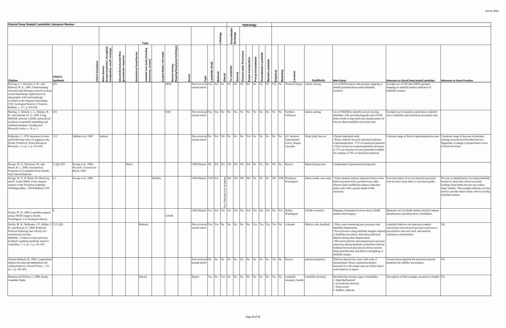
June 8, 2016
Citation
Cited in
Synthesis Cit
ed
in A
nn
ota
tio
n
Wat
er
Bal
ance
(Eva
po
tran
spir
atio
n, t
hro
ugh
fall,
tran
spir
atio
n, r
un
off
, re
char
ge)
Satu
rate
d/u
nsa
tura
ted
flo
w
(gro
un
dw
ate
r re
spo
nse
)
Ge
ote
chn
ical
Stu
dy/
Re
vie
w
Lan
dsl
ide
Cas
e S
tud
y (i
ncl
ud
ing
inve
nto
rie
s, r
evi
ew
s)
Co
up
led
Mo
de
l / G
IS m
od
el
Re
mo
te S
en
sin
g -
Map
pin
g/G
eo
ph
ysic
al t
ech
niq
ue
s
Ru
no
ut
Ty
pe
La
nd
sli
de
Stu
dy
Be
dro
ck
Gla
cia
l
To
La
nd
sli
de
Ge
ne
ral
Gro
un
d w
ate
r P
roc
es
se
s
Ev
ap
o t
ran
sp
ira
tio
n
Pre
cip
-Gro
un
dw
ate
r
Gro
un
dw
ate
r-L
an
ds
lid
e
Ra
infa
ll-L
an
ds
lid
e
Em
pir
ica
l
Mo
de
llin
g
Lo
ca
tio
n
KeyWords Main Points Relevance to Glacial Deep Seated Landslides Relevance to Forest Practices
Gro
un
dw
ate
r R
ec
ha
rge
Glacial Deep Seated Landslide Literature Review
Lit
ho
log
y
Hydrology
Topic
Roering, J. J., Kirchner, J. W., and Dietrich, W. E., 2005, Characterizing structural and lithologic controls on deep-seated landsliding: Implications for topographic relief and landscape evolution in the Oregon Coast Range, USA: Geological Society of America Bulletin, v. 117, p. 654-668.
Q7) DEM Peer-reviewed journal article
Yes Yes No No No No No No No No Yes No Western Oregon remote sensing Use of DEM analysis and geologic mapping to identify potential deep-seated landslide locations.
Example use of GIS data (DEM, geologic mapping) to identify features indicative of landslide location.
Roering, J., Stimely, L. L., Mackey, B. H., and Schmidt, D. A., 2009, Using DInSAR, airborne LiDAR, and archival air photos to quantify landsliding and sediment transport: Geophysical Research Letters, v. 36, p. 5.
Q7) SAR Peer-reviewed journal article
Yes Yes No No No No No No No No No No Northern California
remote sensing Use of DInSAR to identify actively moving landslides with aerial photographs and LiDAR point clouds to map multi-year displacements of trees to obtain landslide movement rates.
Example use of remotely sensed data to identify active landslides and constraing movement rates.
Rothacher, J., 1970, Increases in water yield following clear-cut logging in the Pacific Northwest: Water Resources Research, v. 6, no. 2, p. 653-658.
13.2 Hubbart et al, 2007 Indirect Peer-reviewed journal article
No NA NA No No No Yes No No No No No H.J. Andrews Experimental Forest, Oregon Cascades
Water yield, harvest • Paired watershed study.• Water yield for forested watershed indicates evapotranspiration ~37% of annual precipitation. • Clear-cut harvest evapotranspiration decreases to 17%: an increase in water potentiall available for recharge of 20% of annual precipitation.
Contrains range of forest evapotranspiration rates. Constrains range of increase in potential recharge associated with timber harvest.Magnitude of change is proportional to area of basin harvested.
Savage, W. Z., Morrissey, M., and Baum, R. L., 2000, Geotechnical Properties for Landslide-Prone Seattle-Area Glacial Deposits.
5, Q2), Q3) Savage et al., 2000; Picarelli, Urciuoli and Russo, 2004
Direct USGS Report No NA NA NA NA NA NA No No No NA Na Review Material properities Compendium of geotechnical properties
Savage, W. Z., R. Baum, M. Morrissey, and B. Arndt (2000), Finite-element analysis of the Woodway landslide, WashingtonRep. , USGS Bulletin 2180
6.1 Savage et al., 2000 Stability USGS Report YES NA
Yes
, Out
was
h ov
er la
cust
rine NO NO NO NO No No No NO YES Woodway,
Washingtonfailure model, case study • Finite-element analysis indicated failure of the
bluff associated with a perched water table, whereas limit-equilibrium analysis indicated failure only with a greater depth of full saturation.
First-time failure of in-situ material associated with elevated water table in a perched aquifer.
We rely on identification of existing landslide features to determine where increased recharge from timber harvest may reduce slope stability. This example indicates we also need to consider intact slopes with no existing landslide features.
Schulz, W. H., 2004, Landslide mapped using LIDAR imagery, Seattle, Washington: U.S. Geological Survey.
8
LiDAR
USGS Report Yes NA NA NA NA NA NA NA NA NA NA NA Seattle, Washington
LiDAR, inventory Mapping of landslide locations from LiDAR shaded relief imagery.
Illustrates use of LiDAR shaded relief for manual identification and delineation of landslides.
Schulz, W. H., McKenna, J. P., Kibler, J. D., and Biavati, G., 2009, Relations between hydrology and velocity of a continuously moving landslide—evidence of pore-pressure feedback regulating landslide motion?: Landslides, v. 6, no. 3, p. 181-190.
5.15, Q3) Bedrock Peer-reviewed journal article
Yes Yes No No No No No Yes Yes Yes Yes No Colorado Dilative soils, feedback • Three years monitoring pore pressures and landslide displacments.• Pore-pressures along landslide margins respond to landslide movement, indicating undrained dilation during shear displacement. • Movement patterns and marginal pore-pressure reductions during landslide acceleration indicate feedback between pore-pressre-driven motion along landslide base and dilative strengthing of landslide margin.
Landslide behavior can represent complex interactions between pore-pressure responses to precipitation and snow melt, and material responses to deformation.
NA
Schulze-Makuch, D., 2005, Longitudinal dispersivity data and implications for scaling behavior: Ground Water, v. 43, no. 3, p. 443-456.
Peer-reviewed journal article
No No No No No No No No No No Yes No Review material properties Effective dispersivity varies with scale of measurement. Hence, material properties measured in a lab sample may not reflect macro-scale behavior in slopes.
Caveats about applying lab-measured material properites for stability assessments.
NA
Shannon and Wilson, I., 2000, Seattle Landslide Study.
Glacial Report Yes No Yes No No No No No No No Yes No Landslide inventory, Seattle
Landslide inventory Identified four primary types of landslides:1. High-bluff peeloff2. Groundwater blowout3. Deep-seated4. Shallow colluvial
Description of field examples, locations in Seattle NA
Page 20 of 24

June 8, 2016
Citation
Cited in
Synthesis Cit
ed
in A
nn
ota
tio
n
Wat
er
Bal
ance
(Eva
po
tran
spir
atio
n, t
hro
ugh
fall,
tran
spir
atio
n, r
un
off
, re
char
ge)
Satu
rate
d/u
nsa
tura
ted
flo
w
(gro
un
dw
ate
r re
spo
nse
)
Ge
ote
chn
ical
Stu
dy/
Re
vie
w
Lan
dsl
ide
Cas
e S
tud
y (i
ncl
ud
ing
inve
nto
rie
s, r
evi
ew
s)
Co
up
led
Mo
de
l / G
IS m
od
el
Re
mo
te S
en
sin
g -
Map
pin
g/G
eo
ph
ysic
al t
ech
niq
ue
s
Ru
no
ut
Ty
pe
La
nd
sli
de
Stu
dy
Be
dro
ck
Gla
cia
l
To
La
nd
sli
de
Ge
ne
ral
Gro
un
d w
ate
r P
roc
es
se
s
Ev
ap
o t
ran
sp
ira
tio
n
Pre
cip
-Gro
un
dw
ate
r
Gro
un
dw
ate
r-L
an
ds
lid
e
Ra
infa
ll-L
an
ds
lid
e
Em
pir
ica
l
Mo
de
llin
g
Lo
ca
tio
n
KeyWords Main Points Relevance to Glacial Deep Seated Landslides Relevance to Forest Practices
Gro
un
dw
ate
r R
ec
ha
rge
Glacial Deep Seated Landslide Literature Review
Lit
ho
log
y
Hydrology
Topic
Shipman, H., 2001, Coastal Landsliding on Puget Sound: A review of landslides occurring between 1996 and 1999: Shorelands and Environmental Assistance Program, Washington Department of Ecology.
6.1, 6.5, 6.7 8, Q5)
Glacial Report Yes No Yes No No No No No No No Yes No Puget Sound Field examples • Reports on high incidences of coastal landsliding in winters of 1996-97 and 1998-99.• Landslides in 1996-97 occurred in response to intense rainstorms and rain-on-snow events. Landslides were predominately shallow.• Landslides in 1998-99 occurred during a wet 3-month period following 3 years with above average precipitation. Landslides were predominately deep-seated and not associated with specific storm events.
Descriptions of field examples, locations across Puget Sound coastline.
NA
Smerdon, B. D., Redding, T. E., and Beckers, J., 2009, An overview of the effects of forest management on groundwater hydrology: BC Journal of Ecosystems and Management, v. 10, no. 1, p. 22-44.
Q1) Hotta et al., 2010 Indirect Peer-reviewed journal article
No NA NA NA NA Yes No Yes No No Yes No Focused on British Columbia, but cites studies worldwide
Groundwater, forest practices
• Review paper discussing forest hydrology• Provides extensive review of studies that document water yield and groundwater responses to forest practices.
Not discussed. • Harvest increases soil moisture and water table elevations.• Harvest increases groundwater recharge.• Harvest effects on regional groundwater fluxes may not be manifest for decades.
Stark, T. D., Baghdady, A. K., Hungr, O., and Aaron, J., Submitted 2016, SR530 landslide of 22 March 2014 - material properities and failure mechanism: Journal of Geotechnical and Geoenvironmental Engineering.
5.13, 7.2 Glacial Indirect Submitted article in review
Yes No Yes No No No No No No No Yes Yes SR530 landslide, Stillaguamish Valley, Washington
Mobility, Soil properties • Another explanation for high mobility of SR530 landslide.• Initial failure of ancient landslide bench onto saturated debris from previous landslides caused liquifaction of debris.• Loss of support caused retrogression into Whitman Bench.
• The details of why this landslide exhibited such high mobility may help in identifying similar hazards elsewhere. • This scenario implies that sites subject to surface compression by landsliding of slopes above pose such a hazard.
Unsure
Stednick, J. D., 1996, Monitoring the effects of timber harvest on annual water yield: Journal of Hydrology, v. 176, p. 79-95.
13.2 Hubbart et al, 2007 Indirect Peer-reviewed journal article
No No No No No No
Yes
Wat
er Y
ield No No No Yes No World Wide Water yield, harvest • Compendium of paired-watershed studies
examining effects of timber harvest on water yield.• Provides equations giving water yield increase as function of percent area harvested. For the Pacific Coast: Y = 4.4x, where Y is increased water yield in mm and x is percentage of basin harvested.• These studies indicate that measurable increases in water yield after harvest can be resolved only after 20% to 25% of basin area is harvested.
Constrains range of potential effects of evapotranspiration (estimated as difference between precipitation and water yield) on recharge.
Illustrates effect of harvest on water yield.
Stewart, G., Dieu, J., Phillips, J., O'Connor, M., and Velduisen, C., 2013, The Mass Wasting Effectiveness Monitoring Project: An examination of the landslide response to the December 2007 storm in Southwestern Washington: Cooperative Monitoring, Evaluation and Research committee of the Washington State Forest Practices Board.
Q7) CMER report Yes NA NA No No No No No No No Yes No Southwestern Washington
Inventory, field examples Field-based inventory and analysis of landslides following Dec 2007 storm.
Deep-seated landslides mapped in the inventory can provide an important data source.
Deep-seated landslides mapped in the inventory can provide an important data source.
Stumpf, A., and Kerle, N., 2011, Object-oriented mapping of landslides using Random Forests: Remote Sensing of Environment, v. 115, p. 2564-2577.
8
Object oriented
Peer-reviewed journal article
Yes NA NA NA NA NA NA NA NA NA NA NA Haiti, Italy, China, France
Object oriented, inventory, remote sensing
Object-oriented techniques incorporating machine learning techniques for training.
More options for using remotely sensed data.
Sumioka, S. S., and Bauer, H. H., 2004, Estimating Ground-Water Recharge from Precipitation on Whidbey and Camano Islands, Island County, Washington, Water Years 1998 and 1999.
Sumioka & Bauer, 2004; Orr, Bauer, and Wayenberg, 2002
Page 21 of 24

June 8, 2016
Citation
Cited in
Synthesis Cit
ed
in A
nn
ota
tio
n
Wat
er
Bal
ance
(Eva
po
tran
spir
atio
n, t
hro
ugh
fall,
tran
spir
atio
n, r
un
off
, re
char
ge)
Satu
rate
d/u
nsa
tura
ted
flo
w
(gro
un
dw
ate
r re
spo
nse
)
Ge
ote
chn
ical
Stu
dy/
Re
vie
w
Lan
dsl
ide
Cas
e S
tud
y (i
ncl
ud
ing
inve
nto
rie
s, r
evi
ew
s)
Co
up
led
Mo
de
l / G
IS m
od
el
Re
mo
te S
en
sin
g -
Map
pin
g/G
eo
ph
ysic
al t
ech
niq
ue
s
Ru
no
ut
Ty
pe
La
nd
sli
de
Stu
dy
Be
dro
ck
Gla
cia
l
To
La
nd
sli
de
Ge
ne
ral
Gro
un
d w
ate
r P
roc
es
se
s
Ev
ap
o t
ran
sp
ira
tio
n
Pre
cip
-Gro
un
dw
ate
r
Gro
un
dw
ate
r-L
an
ds
lid
e
Ra
infa
ll-L
an
ds
lid
e
Em
pir
ica
l
Mo
de
llin
g
Lo
ca
tio
n
KeyWords Main Points Relevance to Glacial Deep Seated Landslides Relevance to Forest Practices
Gro
un
dw
ate
r R
ec
ha
rge
Glacial Deep Seated Landslide Literature Review
Lit
ho
log
y
Hydrology
Topic
Take, W. A., and Bolton, M. D., 2011, Seasonal ratcheting and softening in clay slopes, leading to first-time failure: Géotechnique, v. 61, no. 9, p. 757-769.
5.13 Picarelli, Urciuoli and Russo, 2004
Indirect Peer-reviewed journal article
Yes No No No No No No Yes No Experimental Material properties, progressive failure
• Document seasonal “ratcheting” (intermittent creep) associated with pore-pressure variations and accompanying weakening of soil at the toe of a slope and initiation of progressive failure. • Limit equilibrium calculations must use residual strengths to incorporate these effects into factor-of-safety analyses.
Creep a potential indicator of progressive failure. Field indicators of creep over fine-grained soils potential indicator of progressive failure.
Thorsen, G. W., 1989, Landslide Provinces in Washington, Engineering Geology in Washington. Bulletin 78, Volume 1: Olympia, Washington State Department of Natural Resources, Division of Geology and Earth Resources, p. 71-89.
3.1 Glacial Book chapter Yes Yes Yes No No No No No No No No No Washington Description of landslide types and provinces in Washington
NA NA
Tubbs, D. W., 1974, Landslides in Seattle: State of Washington, Department of Natural Resources, Division of Geology and Earth Resources.
6 Glacial DNR report Yes No Yes No No No No No No No Yes No Seattle Field examples • Describes landslide types and associated processes observed in Seattle.• Describes Esperance Sand/Lawton Clay influence on generation of unconfined aquifer and relationship with landsliding.
Examples of landslides and landslide settings.
Urciuoli, G., 2002, Strains preceding failure in infinite slopes: The International Journal of Geomechanics, v. 2, no. 1, p. 93-112.
Indirect Peer-reviewed journal article
Yes NA NA NA NA NA NA No No No NA Yes Theory Ductile deformation Infinite slope analysis of strains in a plastic material during stress evolution associated with increasing pore pressure.
NA NA
Vaccaro, J. J., 2007, A deep percolation model for estimating ground-water recharge: Documentation of modules for the modular modeling system of the U.S. Geological Survey: US Geological Survey.
13 Water balance
USGS Report No NA NA No Yes No Yes No No No No Yes Theory Water budget model Describes the soil-moisture water-budget model widely used by USGS for estimating recharge to groundwater for regions in Washington State.
Spatially distributed model for soil-moisture water budget accounting for evapotranspiration, soil properties, and substrate infiltration capacity. Does not include lateral subsurface flow.
Could be used for assessing effects of changes in land cover on recharge rate.
Vallet, A., Bertrand, C., Fabbri, O., and Mudry, J., 2015, An efficient workflow to accurately compute groundwater recharge for the study of rainfall-triggered deep-seated landslides, application to the Séchilienne unstable slope (western Alps): Hydrol. Earth Syst. Sci., v. 19, p. 427-449.
6.6, Q6) Batallan & De Smedt, 2007; Miller & Sias, 1998
Water balance
Peer-reviewed journal article
Yes Yes No Yes No No Yes No No Yes Yes Yes French Alps Water budget model • Development of spatially distributed soil-moisture water-balance model to calculate recharge over recharge area of a landslide.• Results show that landslide displacements are better explained using recharge calculated by the model for a time series of rainfall than the rainfall time series itself.
Landslide response may be influenced by land-cover-associated evapotranspiration.
This modeling strategy can be applied to estimate changes in recharge associated with timber harvest.
van Asch, T. W. J., Hendriks, M. R., Hessel, R., and Rappange, F. E., 1996, Hydrological triggering conditions of landslides in varved clays in the French Alps: Engineering Geology, v. 42, p. 239-251.
5.10 Glacial (review)
Peer-reviewed journal article
Yes No Yes No No Yes No No No No Yes No French Alps, alpine glacial-lacustrine varved clays
Fissures Similar to van der Spek et al., 2013
Van Asch, T. W. J., Malet, J. P., and Bogaard, T. A., 2009, The effect of groundwater fluctuations on the velocity pattern of slow-moving landslides: Natural Hazards and Earth System Science, v. 9, p. 739-749.
5.15, Q3) Glacial Peer-reviewed journal article
Yes No Yes No No No No No No No Yes Yes Analyses of landslide displacement and pore-water pressures indicates an apparent increase in shear-zone strength with increasing water pressure. Several feedback mechanisms are discussed, including potential for dilative strengthing of the shear zone during displacement.
• This study reports on two well-documented, large, slow-moving glacial deep-seated landslides.• Shear-strain strengthing due to dilation during deformation may play a similar role for behavior of landslides in Washington, that are also developed in dense glacial-lacustrine deposits.
NA
van Asch, T. W. J., Malet, J.P., van Beek, L. P. H., and Amitrano, D., 2007, Techniques, issues and advances in numerical modelling of landslide hazard: Bulletin de la Société Géologique de France, v. 178, no. 2, p. 65-88.
Miller & Sias, 1998 Stability Peer-reviewed journal article
Yes NA NA NA NA NA NA No No No NA Yes Review Model, review • Europe-focused and slightly dated. • Focused on physically based models.
Page 22 of 24

June 8, 2016
Citation
Cited in
Synthesis Cit
ed
in A
nn
ota
tio
n
Wat
er
Bal
ance
(Eva
po
tran
spir
atio
n, t
hro
ugh
fall,
tran
spir
atio
n, r
un
off
, re
char
ge)
Satu
rate
d/u
nsa
tura
ted
flo
w
(gro
un
dw
ate
r re
spo
nse
)
Ge
ote
chn
ical
Stu
dy/
Re
vie
w
Lan
dsl
ide
Cas
e S
tud
y (i
ncl
ud
ing
inve
nto
rie
s, r
evi
ew
s)
Co
up
led
Mo
de
l / G
IS m
od
el
Re
mo
te S
en
sin
g -
Map
pin
g/G
eo
ph
ysic
al t
ech
niq
ue
s
Ru
no
ut
Ty
pe
La
nd
sli
de
Stu
dy
Be
dro
ck
Gla
cia
l
To
La
nd
sli
de
Ge
ne
ral
Gro
un
d w
ate
r P
roc
es
se
s
Ev
ap
o t
ran
sp
ira
tio
n
Pre
cip
-Gro
un
dw
ate
r
Gro
un
dw
ate
r-L
an
ds
lid
e
Ra
infa
ll-L
an
ds
lid
e
Em
pir
ica
l
Mo
de
llin
g
Lo
ca
tio
n
KeyWords Main Points Relevance to Glacial Deep Seated Landslides Relevance to Forest Practices
Gro
un
dw
ate
r R
ec
ha
rge
Glacial Deep Seated Landslide Literature Review
Lit
ho
log
y
Hydrology
Topic
Van Asch, T. W. J., Van Beek, L. P. H., and Bogaard, T. A., 2009, The diversity in hydrological triggering systems of landslides, The First Italian Workshop on Landslides: Napoli, Itali, p. 151-156.
Indirect Conference Proceedings, Paper
Yes NA NA NA NA Yes NA Yes Yes Yes Yes NA Review Review Examined hydrological triggers for a variety of landslide types.
• Deep-seated landslides sensitive to cumulative recharge over long time periods and to factors that influence recharge rate, such as changes in ET.• Preferential flow paths for water into a landslide can profoundly affect pore-pressure responses to precipitation.
Land cover influences on evapotranspiration and consequent rates of recharge are discussed. In particular, modeling results indicate that changes in land cover result in changes in the frequency and duration in movement of active landslides
Van Den Eeckhaut, M., Kerle, N., Poesen, J., and Hervás, J., 2012, Object-oriented identification of forested landslides with derivatives of single pulse LiDAR data: Geomorphology, v. 173-174, p. 30-42.
8
Object oriented, LiDAR
Peer-reviewed journal article
Yes NA NA NA NA NA NA NA NA NA NA NA Belgium Object oriented, inventory, remote sensing, LiDAR
Object-oriented techniques using LiDAR derived attributes, rather than from imagery.
More options for using remotely sensed data.
van der Spek, J. E., Bogaard, T., and Bakker, M., 2013, Characterization of groundwater dynamics in landslide in varved clays: Hydrology and Earth System Science, v. 17, p. 2171-2183.
Picarelli, Urciuoli and Russo, 2004
Direct Peer-reviewed journal article
Yes No Yes No No Yes No Yes Yes Yes Yes French Alps, alpine glacial-lacustrine varved clays
Fissures Conceptual and numerical model for recharge through fissures into varved clays
Useful to keep the conceptual model in mind – mostly the potential for infiltration through vertical fissures, but numerical model probably not of much use for us.
Vaugeois, L., and Dieu, J., 2007, Memorandum: Groundwater Recharge to Glacial Deep Seated Scoping documents.
12, Q7) Memo Yes No Yes NA NA NA NA NA NA NA NA NA Describes proposed approaches for studies to characterize glacial deep-seated landslide susceptibility to forest practices
Walsh, T. J., Pringle, P. T., and Palmer, S. P., 2001, Working a geologic disaster: Washington Geology, v. 28, no. 3, p. 6-18.
6.1 Journal article NA NA NA NA NA NA NA NA NA NA NA NA Earthquake trigger Report includes mention of landslides associated with the 2001 Nisqually earthquake
Wartman, J., Montgomery, D. R., Anderson, S. A., Keaton, J. R., Benoît, J., dela Chapelle, J., and Gilbert, R., 2016, The 22 March 2014 Osolandslide, Washington, USA: Geomorphology, v. 253, p. 275-288.
7.2, Q3)
Glacial
Peer-reviewed journal article
Yes No Yes No No No No No No No Yes No SR530 landslide, Stillaguamish Valley, Washington
field example Summary of GEER report observations from Oso.
Washington Forest Practices Board, 2015, Guidelines for Evaluating Potentially Unstable Slopes and Landforms, Forest Practices Board Manual.
6.1, Q4 Forest Practices Board Manual
NA NA NA NA NA NA NA NA NA NA NA NA Guidelines for recognition of glacial deep-seated landslides and associated groundwater recharge areas.
Washington State Department of Transportation, 2015, SR 530 MP 35 to 41 Geotechnical Study.
6.4, 6.5, Q3) Miller & Sias, 1998 Glacial WADOT Geotechnical Report
Yes No Yes NO NO YES NO Yes No No YES NO Stillaguamish River valley, Washington
material properties, pore pressure
• Stratigraphy and material properties for glacial terrace and landslide deposit across Stillaguamish River; piezometers in both.• Piezometer + rain gage monitoring, Dec 2014-May2015, within each stratigraphic unit on Whitman Bench and within and below landslide debris on BA6S. Artesian head in underlying confined aquifer, but pore pressures spatially variable. Piezometer within the BA6S debris recorded muted pore-pressure response to precipitation (Appendix C). • BA6S; low-gradient, very long failure surface in lacustrine deposit; horizontal bedding observed in deep portions of the lacustrine deposits (check).
Whitman Bench: • Unconfined and confined aquifers with different temporal response.• Artesion head encountered within confined aquifer• High lateral pore-pressure heterogeneity within confined aquifer.BA6S: (across river from SR530 landslide)• Event-based pore-pressure response• Low-gradient failure surface in lacustrine deposits
Confined aquifers, both below the till and below the deeper, fine-grained deposits, indicate that groundwater recharge areas providing flow to deep seated landslides may be quite extensive. Recharge zones to these aquifers are not easily characterized; the response of water flux and pressure heads within these aquifers to long-term variation in rates of recharge are unknown (they showed no response to storm events).
Welch, L. A., Allen, D. M., and Van Meerveld, H. J. I., 2012, Topographic controls on deep groundwater contributions to mountain headwater streams and sensitivity to available recharge: Canadian Water Resources Journal, v. 37, no. 4, p. 349-371.
Q4), Q7) Indirect Peer-reviewed journal article
No Yes No No Yes Yes No No No NO No Yes Okanagan Basin, British Columbia
3-D groundwater model • Groundwater flow paths can bypass small drainage basins, so that surface drainage divides do not match groundwater drainage divides.• Recharge areas expand and contract with changes in recharge rate.
Estimates of recharge area based on surface topography may be incorrect.
Page 23 of 24

June 8, 2016
Citation
Cited in
Synthesis Cit
ed
in A
nn
ota
tio
n
Wat
er
Bal
ance
(Eva
po
tran
spir
atio
n, t
hro
ugh
fall,
tran
spir
atio
n, r
un
off
, re
char
ge)
Satu
rate
d/u
nsa
tura
ted
flo
w
(gro
un
dw
ate
r re
spo
nse
)
Ge
ote
chn
ical
Stu
dy/
Re
vie
w
Lan
dsl
ide
Cas
e S
tud
y (i
ncl
ud
ing
inve
nto
rie
s, r
evi
ew
s)
Co
up
led
Mo
de
l / G
IS m
od
el
Re
mo
te S
en
sin
g -
Map
pin
g/G
eo
ph
ysic
al t
ech
niq
ue
s
Ru
no
ut
Ty
pe
La
nd
sli
de
Stu
dy
Be
dro
ck
Gla
cia
l
To
La
nd
sli
de
Ge
ne
ral
Gro
un
d w
ate
r P
roc
es
se
s
Ev
ap
o t
ran
sp
ira
tio
n
Pre
cip
-Gro
un
dw
ate
r
Gro
un
dw
ate
r-L
an
ds
lid
e
Ra
infa
ll-L
an
ds
lid
e
Em
pir
ica
l
Mo
de
llin
g
Lo
ca
tio
n
KeyWords Main Points Relevance to Glacial Deep Seated Landslides Relevance to Forest Practices
Gro
un
dw
ate
r R
ec
ha
rge
Glacial Deep Seated Landslide Literature Review
Lit
ho
log
y
Hydrology
Topic
Welch, L. A., and Allen, D. M., 2012, Consistency of groundwater flow patterns in mountainous topography: Implications for valley bottom water replenishment and for defining groundwater flow boundaries: Water Resources Research, v. 48, p. W05526.
5.6 Indirect Peer-reviewed journal article
No Yes No No Yes Yes No No No NO No Yes Okanagan Basin, British Columbia
3-D groundwater model Examine relationship between topographic and groundwater drainage divides using 3-D groundwater model.
Offers insight for delineating recharge areas within nested basins.
Wildrick, L., 2007, Groundwater Recharge Areas Modeling: CMER Scoping Document.
12, Q7) CMER scoping template
Yes No Yes Yes Yes Yes No No No No No Yes model 3-D groundwater model, Proposed strategy for applying groundwater models to characteristic site settings for glacial deep-seated landslides to clarify time scales and pore-pressure responses to harvest over recharge areas.
Presents a coherent approach to identify controls on pore-pressure variations affecting glacial deep-seated landslides.
Young, A. P., Guza, R. T., Flick, R. E., O'Reilly, W. C., and Gutierrez, R., 2009, Rain, waves, and short-term evolution of composite seacliffs in southern California: Marine Geology, v. 267, no. 1-2, p. 1-7.
Q5) Bedrock Peer-reviewed journal article
Yes Yes No No No No No No No No Yes No Southern California
coastal cliff, wave erosion
• Conceptual model of interaction between wave erosion and landsliding of coastal cliffs.• Actual cliff retreat rates correlate with periods of high rainfall, not high wave height.
Many glacial deep-seated landslides occur along coastal bluffs. This study provides insights for interactions between wave erosion and landslide processes.
NA
Zhao, C., Lu, Z., Zhang, Q., and de la Fuente, J., 2012, Large-area landslide detection and monitoring with ALOS/PALSAR imagery data over Northern California and Southern Oregon, USA: Remote Sensing of Environment, v. 124, p. 348-359.
12, Q7) SAR Peer-reviewed journal article
Yes Yes No No No No No No No No No Yes Northern California and Souther Oregon
SAR, remote sensing • Time series of radar imagery (ALOS/PALSAR) used to identify active landslides.• More than 50 active landslides identified.• Comparison with rainfall indicates landslide displacement correlates with rainfall rate with lag of 1-2 months.
SAR data and methods may provide a means for regional detection of active landslides and measurement of movement rates.
Page 24 of 24