livelihood adaptations in upland, lowland and coastal ... · livelihood adaptations in upland,...
TRANSCRIPT

Expert Conference on Development of Island's Sustainable Societies 29-30 June, 2014 Okinawa, JAPAN
Livelihood adaptations in upland, lowland and coastal ecosystems of Infanta, Quezon: A
decade after the flashflood disaster
Damasa B. Magcale-Macandog Institute of Biological Sciences, University of the Philippines Los Baños
Co-authors: Lilibeth A. Acosta, Maria Victoria O. Espaldon, Elaine Kuan-Hui Lin, Paula Beatrice M. Macandog, Elena A. Eugenio, Edwin Rosell Abucay, Joan Pauline P. Talubo
Ma. Charisma T. Malenab, and Marlon G. Reblora

Livelihood adaptations in upland, lowland and coastal ecosystems of Infanta, Quezon: A decade after the
flashflood disaster Outline:
1. Introduction
2. Objectives of the study
3. Case study area: Infanta, Quezon
4. Methods: Survey, FGD
5. Results
5.1 HH demographics in 3 ecological zones
5.2 Impacts on livelihoods
5.3 Livelihood adaptations
6. Conclusions

Philippines is one of the world’s most disaster-prone country (Center for Research on the Epidemiology of Disasters, 2010).
An average of 20 typhoons crosses the Philippine area of responsibility annually (PAGASA-DOST)
Typhoons in the Philippines
caused floods &
landslides due to:
lost up to 80 percent of
mangrove forests in the
last 50 years
decrease in upland
forest cover from 27.5M
to 6.7M has between
1900 and 1990
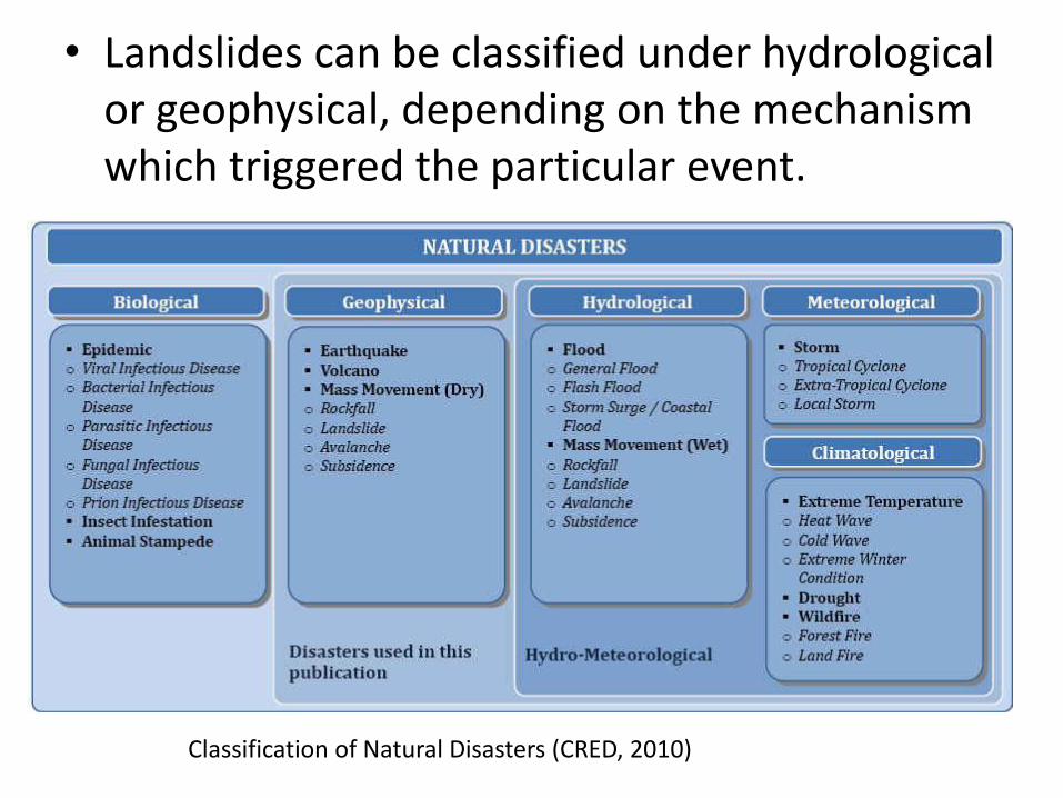
• Landslides can be classified under hydrological or geophysical, depending on the mechanism which triggered the particular event.
Classification of Natural Disasters (CRED, 2010)

YEAR RAINFALL EVENT LANDSLIDE
2012 Pablo New Bataan, Compostela Valley
2010 Ondoy Parts of Metro Manila and Central Luzon
2009 Pepeng Northern Philippines
2006 Caloy Guinsaugon, Southern Leyte
2006 Durian Albay
2006 Milenyo Mt. Makiling in Laguna
2004 Winnie, Unding, Violeta, Yoyong
Infanta, Quezon
2000 Edeng Payatas
1999 Ising Cherry Hills
1991 Uring Ormoc, Leyte
Philippines: Rainfall-induced Landslide events
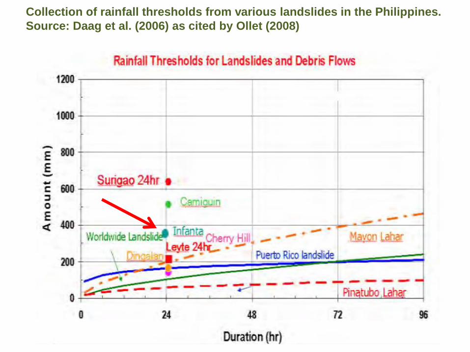
Collection of rainfall thresholds from various landslides in the Philippines.
Source: Daag et al. (2006) as cited by Ollet (2008)
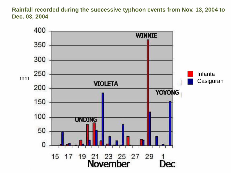
Rainfall recorded during the successive typhoon events from Nov. 13, 2004 to
Dec. 03, 2004
mm Infanta
Casiguran

Daily rainfall from 01 October 2004 to 29 February 2008, Infanta, Quezon. (Data Source: PAGASA weather station in Infanta, Quezon)
24 - hr total rainfall threshold level
30 Nov. 2004 Landslide and mudslide event (TD Winnie)
Super typhoon Milenyo
Sept. 27, 2006)
Super typhoon Reming
(Nov. 26-Dec 01, 2006)
Typhoon Seniang
(10 Dec. 2006)

Between Nov. 14 and Dec. 29 of 2004, four successive typhoons (Winnie, Unding, Violeta and Yoyong) hit the Eastern coast of Luzon. Heavy rainfall caused massive landslides and devastating flash floods.
The 2004 Landslide Event: Infanta, Quezon
Photos courtesy of Infanta LGU

These brought about damages to the lives and properties of communities in the towns of Real, General Nakar and Infanta in Quezon and Dingalan in Aurora.
The calamity caused major physical damages and claimed the lives of more than 1,000 people.
As reported by the Office of the Civil Defense, more than 2.3 million people were affected and about P4.6 billion were lost in terms of infrastructure and agricultural damages (Cruz, 2005).

The Study Area

Infanta, Quezon
• 144 km northeast of Manila
• Type II Climate: No Dry Season but a very pronounced period of maximum rainfall from November to February
• a floodplain at the foot of the Sierra Madre
• total land area of 342.76 sq. km (34,276 ha)
• Population of 64,866 (Census, 2010 as cited in www.infanta.gov.ph)

Quickbird Satellite Image of Infanta
Brgy. Poblacion Agos River
Images courtesy of PAFID Inc.

Aerial Photos of Infanta
Portion of Agos Watershed
Coastal area of Infanta
Photos courtesy of PAFID Inc.

• To compare the livelihood adaptations in upland, lowland and coastal ecosystems of Infanta, Quezon
OBJECTIVE

Reconnaissance, HH Survey and FGD
- Years: 2008, 2013
- HH demographic
- Livelihood activities
- HH survey: Magsaysay (33), Ilog (39), and
Pinaglapatan (35) – simple random sampling on site
(Cochran, 1977)
- FGD: local communities, LGU officials
Methodology

2013 HH Survey Research Team

MAGSAYSAY
PINAGLAPATAN
ILOG

RESULTS
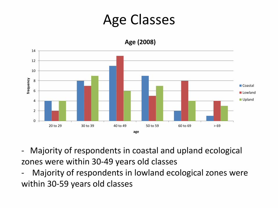
Age Classes
0
2
4
6
8
10
12
14
20 to 29 30 to 39 40 to 49 50 to 59 60 to 69 > 69
fre
qu
en
cy
age
Age (2008)
Coastal
Lowland
Upland
- Majority of respondents in coastal and upland ecological zones were within 30-49 years old classes - Majority of respondents in lowland ecological zones were within 30-59 years old classes

Age Classes
0
2
4
6
8
10
12
14
20 to 29 30 to 39 40 to 49 50 to 59 60 to 69 > 69
fre
qu
en
cy
age
Age (2013)
Coastal
Lowland
Upland
In all three ecological zones, the age classes of majority respondents ranged from 30-69 years old.

Age
0
5
10
15
20 to 29 30 to 39 40 to 49 50 to 59 60 to 69 > 69
fre
qu
en
cy
age
Age (2008)
Coastal
Lowland
Upland
0
2
4
6
8
10
12
14
20 to 29 30 to 39 40 to 49 50 to 59 60 to 69 > 69
fre
qu
en
cy
age
Age (2013)
Coastal
Lowland
Upland

Educational Level
0
5
10
15
20
25
No formal Education Elementary High School Vocational College Grad.
fre
qu
en
cy
education
Education (2008)
Coastal
Lowland
Upland
0
5
10
15
20
No formal Education Elementary High School Vocational College Grad.
fre
qu
en
cy
education
Education (2013)
Coastal
Lowland
Upland
In all three ecological zones, most of the respondents had elementary and high school educational levels

Family Size
0
5
10
15
20
< 2 3 to 5 6 to 8 9 to 11 > 12
fre
qu
en
cy
family size
Family Size (2008)
Coastal
Lowland
Upland
0
5
10
15
20
25
< 2 3 to 5 6 to 8 9 to 11 > 12
fre
qu
en
cy
family size
Family Size (2013)
Coastal
Lowland
Upland
- In 2008, family of majority of respondents has 3-5 and 6-8 family members.. - In 2013, family size was reduced to 3-5 members.
0
10
20
30
0 .01-.5 .51-1 1.01-1.5 1.51-2 >2.01
fre
qu
en
cy
ha
Farm sizes (2004, Before landslide)
Coastal
Lowland
Upland
0
10
20
30
0 .01-.5 .51-1 1.01-1.5 1.51-2 >2.01
fre
qu
en
cy
ha
Farm sizes (2008)
Coastal
Lowland
Upland
0
5
10
15
20
25
30
0 .01-.5 .51-1 1.01-1.5 1.51-2 >2.01
fre
qu
en
cy
ha
Farm sizes (20013)
Coastal
Lowland
Upland
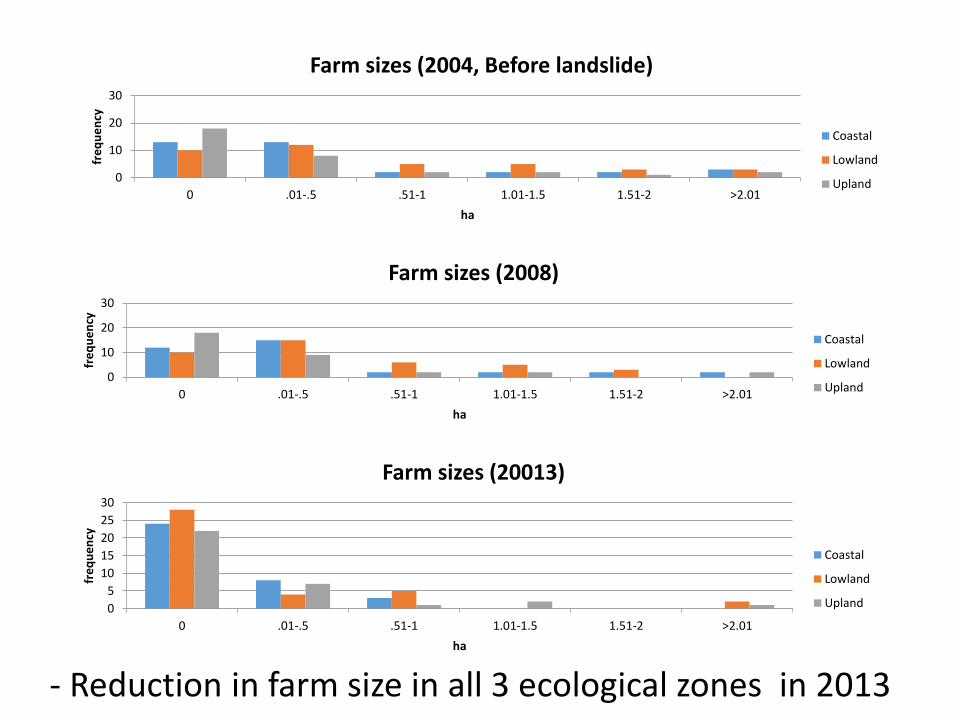
- Reduction in farm size in all 3 ecological zones in 2013

02468
10
Cereals Coconut Vegetables Fruits Cereals andvegetables
Coconut, Fruitsand Trees
Coconut andCereals
Root crops,fruits,
vegetable andcereal
fre
qu
en
cy
crops
Crops (2004, Before Landslide)
Coastal
Lowland
Upland
02468
10
Cereals Coconut Vegetables Fruits Cereals andvegetables
Coconut, Fruitsand Trees
Coconut andCereals
Root crops,fruits,
vegetable andcereal
fre
qu
en
cy
crops
Crops (2013)
Coastal
Lowland
Upland
02468
10
Cereals Coconut Vegetables Fruits Cereals andvegetables
Coconut, Fruitsand Trees
Coconut andCereals
Root crops,fruits,
vegetable andcereal
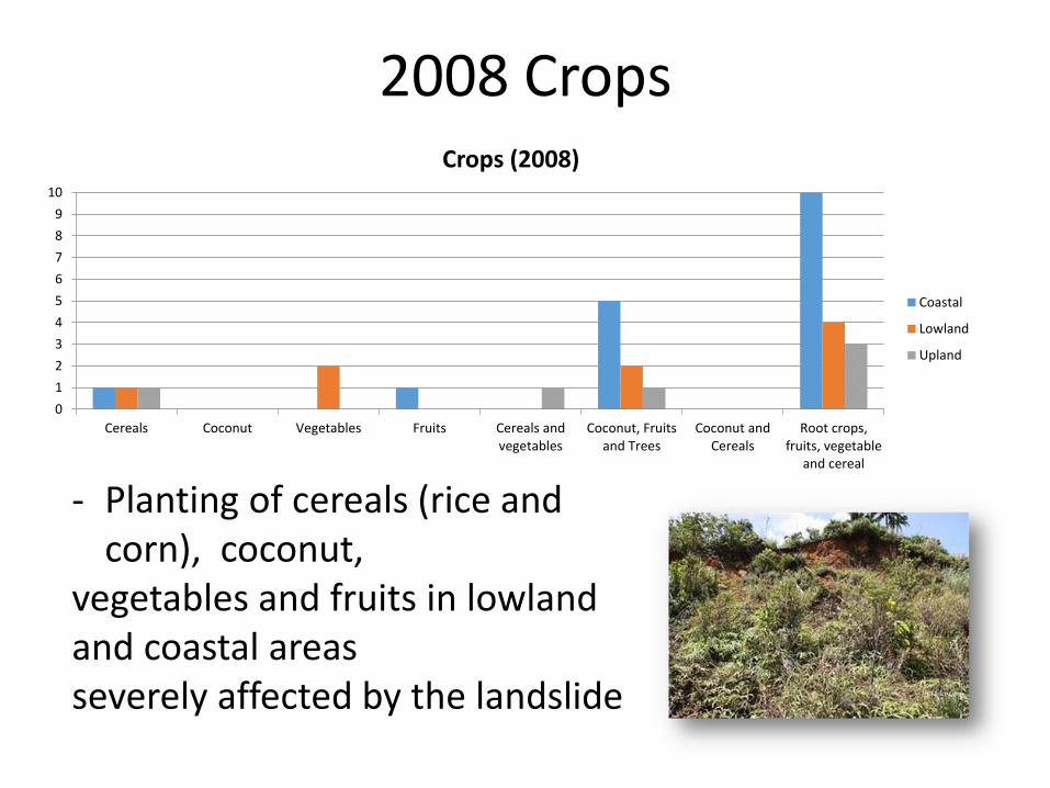
Crops (2008)
Coastal
Lowland
Upland

0
2
4
6
8
10
Cereals Coconut Vegetables Fruits Cereals andvegetables
Coconut, Fruitsand Trees
Coconut andCereals
Root crops,fruits, vegetable
and cereal
fre
qu
en
cy
crops
Crops (2004, Before Landslide)
Coastal
Lowland
Upland
- In all 3 ecological zones: Cereals (rice , corn);
coconut & fruit trees; root crops, fruits, vegetables & cereals - Vegetables grown mainly in lowland areas
2004 Crops
2008 Crops
0
1
2
3
4
5
6
7
8
9
10
Cereals Coconut Vegetables Fruits Cereals andvegetables
Coconut, Fruitsand Trees
Coconut andCereals
Root crops,fruits, vegetable
and cereal
Crops (2008)
Coastal
Lowland
Upland
- Planting of cereals (rice and corn), coconut,
vegetables and fruits in lowland and coastal areas severely affected by the landslide

Crops 2013
0123456789
10
Cereals Coconut Vegetables Fruits Cereals andvegetables
Coconut, Fruitsand Trees
Coconut andCereals
Root crops,fruits, vegetable
and cereal
fre
qu
en
cy
crops
Crops (2013)
Coastal
Lowland
Upland
- Cereals were planted in coastal and upland areas but not in lowland areas - Lowland areas were planted to a combination of root crops, fruits, vegetable and cereals - Vegetables were planted in coastal areas - Some farms in the uplands were planted to multi-storey plantations of coconut, fruits and trees - Coconut and Copra – main crops of Infanta

0
10
20
30
40
Agricultural Business andservices
Employment OFW Charcoal making,firewood and forestproduct gathering
Others
fre
qu
en
cy
livelihood
Livelihood (2004, Before Landslide)
Coastal
Lowland
Upland
0
10
20
30
40
Agricultural Business andservices
Employment OFW Charcoal making,firewood and forestproduct gathering
Others
fre
qu
en
cy
livelihood
Livelihood (2008)
Coastal
Lowland
Upland
0
10
20
30
Agricultural Business andservices
Employment OFW Charcoal making,firewood and forestproduct gathering
Others
fre
qu
en
cy
livelihood
Livelihood (2013)
Coastal
Lowland
Upland

- Agriculture was the main livelihood of respondents from the coastal and upland ecological zones - Charcoal making and forest product gathering was a major livelihood in the uplands - Business and services were the main livelihood of respondents in the lowland ecological zone

- Agriculture was the main livelihood in the coastal zone
- Business and services were the main livelihood in the lowlands
- Charcoal making and forest product gathering were the main livelihood activities in the uplands
- Employment was a minor source of livelihood
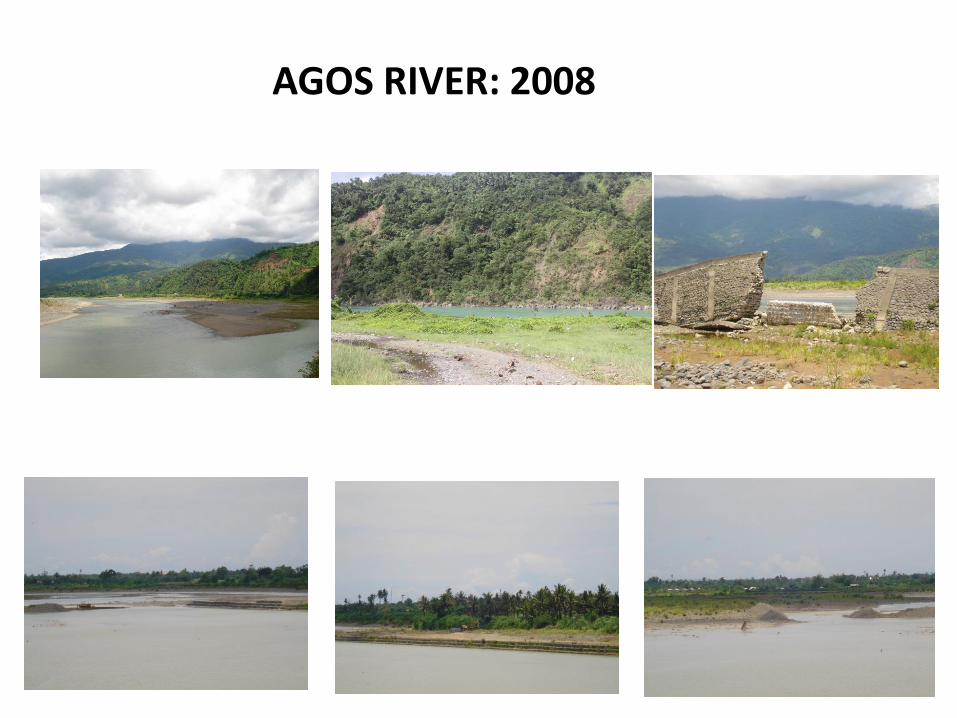
AGOS RIVER: 2008
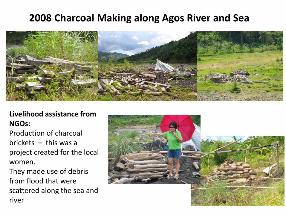
2008 Charcoal Making along Agos River and Sea
Livelihood assistance from NGOs: Production of charcoal brickets – this was a project created for the local women. They made use of debris from flood that were scattered along the sea and river

2008 Upland Ecological Zone

- Agricultural activities in the coastal zone greatly reduced - Charcoal making and forest product gathering in the upland zone greatly reduced - Engaged in OTHER livelihood activities in the 3 ecological zones:
- With the completion of the diversion highway from Infanta to Manila, many residents sought JOBS in Metro Manila - Tricycle driver - Variety stores

2013 Upland and Lowland Ecological Zones

Planting Nipa in coastal areas: 2013
• Previously, there were a lot of abandoned fish ponds.
• The fish ponds were prolific during the 1980s-1990
• Locals started planting nipa trees on these abandoned areas
• NGO ICDAY helped the locals process their permit with DENR, LGU was also a collaborator
• 17 hectares for Community-based Forest Management (CBFM) project was established back in 2002
• The local cooperative: Binonoan Producers’ Cooperative (BiPCo)
• o Mixed plantation
• Aviccennia planted at coastal areas
• Nipa were planted at relatively higher lands
• Households own an average of 4-5 hectares of nipa
• There are currently 100 ha planted with Nipa in Brgy. Binonoan. While there are 80 ha in Brgy Alitas, a neighbour barangay.
• 15 barangays in Infanta plant Nipa trees
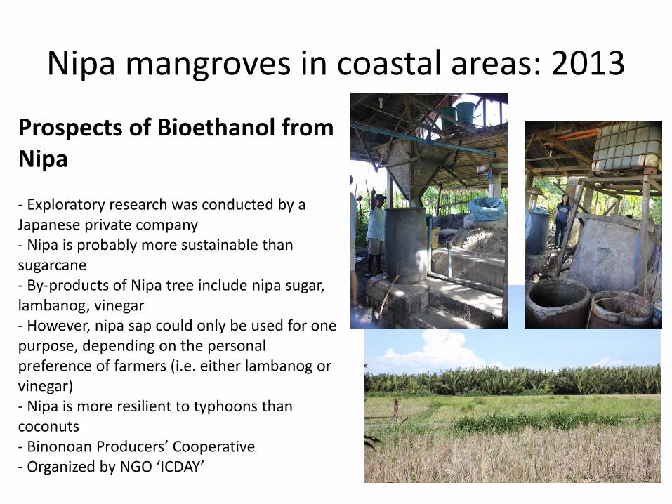
Nipa mangroves in coastal areas: 2013
Prospects of Bioethanol from Nipa - Exploratory research was conducted by a Japanese private company - Nipa is probably more sustainable than sugarcane - By-products of Nipa tree include nipa sugar, lambanog, vinegar - However, nipa sap could only be used for one purpose, depending on the personal preference of farmers (i.e. either lambanog or vinegar) - Nipa is more resilient to typhoons than coconuts - Binonoan Producers’ Cooperative - Organized by NGO ‘ICDAY’

2008 VALE Research Team
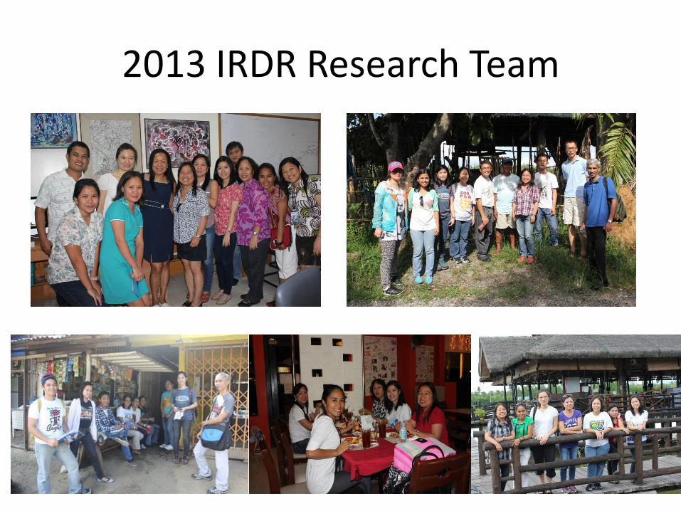
2013 IRDR Research Team
