living with coastal erosion in europe: sediment and space ... · - 1 - the eurosion project this...
TRANSCRIPT
Service contract B4-3301/2001/329175/MAR/B3 “Coastal erosion – Evaluation of the need for action”
Directorate General Environment European Commission
Living with coastal erosion in Europe: Sediment and Space for Sustainability
PART I - Major findings and Policy Recommendations
of the EUROSION project
10 May 2004
National Institute for Coastal and Marine Management of the Netherlands (RIKZ) EUCC – The Coastal Union
IGN France International Autonomous University of Barcelona (UAB)
French Geological Survey (BRGM) French Institute of Environment (IFEN)
EADS Systems & Defence Electronics

TABLE OF CONTENTS
THE EUROSION PROJECT 1
EXECUTIVE SUMMARY 2
FACTORS INFLUENCING COASTAL EROSION 8
MAJOR FINDINGS 14 Finding 1: on coastal squeeze and the loss of sediment 14 Finding 2: on environmental and economic assessment 15 Finding 3: on coastal erosion risk 16 Finding 4: on the mitigation of coastal erosion 17 Finding 5: on information management 21
THE EUROSION VISION 23
FOUR RECOMMENDATIONS TO IMPROVE COASTAL EROSION MANAGEMENT29 EUROSION Recommendation nr. 1 29 EUROSION Recommendation nr. 2 34 EUROSION Recommendation nr. 3 39 EUROSION Recommendation nr. 4 45

- 1 -
THE EUROSION PROJECT
This report “Living with coastal erosion in Europe: Sediment and Space for Sustainability” has been compiled in the framework of EUROSION, under a service contract commissioned in 2002 by the Directorate General Environment (European Commission). This followed a budget amendment by the European Parliament, which requested action to be taken on the issue of coastal erosion. The overall aim of the EUROSION service contract is to provide the European Commission with quantified evidence on coastal erosion in Europe, on the problems caused by it and on the successes and failures of mitigation measures. EUROSION also aims at formulating a set of proposals to bring coastal erosion into the mainstream of coastal management at the European, national, regional and local levels. To meet this aim EUROSION will deliver: Ø a pan-European database (1:100,000) assessing the state of the coast and indicators to
determine the sensitivity to the risk of coastal erosion; Ø guidelines and a prototype for a local information system (1:25,000) for erosion planning
and management at the local to regional scale; Ø a shoreline management guide in the form of an interactive database containing the results
from case studies Ø a policy recommendations report. The report has been drafted on the basis of: Ø the deliverables of the EUROSION project and contributions from the EUROSION team Ø contributions of an international panel of experts, Ø consultation of the EUROSION Steering Group; Ø consultation of the EUROSION Advisory Board, an ad-hoc committee of approximately 50
members in which the various public, private, or non governmental interests on the coast are represented;
Ø two dedicated workshops including members of the Advisory Group and other experts (in 2003);
Ø three consultation meetings in Brussels (in 2004). The authors would like to thank Prof. Job Dronkers, Rob Misdorp, Hugo Niesing (all from RIKZ, the Netherlands), Prof. Francisco Taveira Pinto (EUCC, Portugal), Prof. Roland Paskoff, (EUCC, France), and Prof. Giovanni Randazzo (EUCC, Italy) for their valuable contributions to this report. The results of EUROSION will be presented and discussed at the EUROSION Final Conference in Brussels, on 28 May 2004. All results are or (will be) accessible in www.eurosion.org. Albert Salman, EUCC – The Coastal Union, Leiden – Barcelona – Klaipeda Stéphane Lombardo, RIKZ, The Hague Pat Doody, EUCC, Brampton Cambs., UK 10 May 2004
- 2 -
EXECUTIVE SUMMARY
THE SCALE OF THE PROBLEM All European coastal states are to some extent affected by coastal erosion. About twenty thousand kilometres of coasts, corresponding to 20% 1 face serious impacts in 2004. Most of the impact zones (15,100 km) are actively retreating, some of them in spite of coastal protection works (2,900 km). In addition, another 4,700 km have become artificially stabilised. The situation is illustrated in a complementary document (Part II - EUROSION Maps and Statistics). The area lost or seriously impacted by erosion is estimated to be 15 km2 per year. Within the period 1999-2002, between 250 and 300 houses had to be abandoned in Europe as a result of imminent coastal erosion risk and another 3,000 houses saw their market value decrease by at least 10%. These losses are, however, insignificant compared to the risks of coastal flooding due to the undermining of coastal dunes and sea defences. This threat has the potential to impact on several thousands of square kilometres and millions of people. Over the past 50 years, the population living in European coastal municipalities has more than doubled to reach 70 millions inhabitants in 2001 and the total value of economic assets located within 500 meters from the coastline has multiplied to an estimated 500-1000 billion euros in 2000. Given the predictions for climate change, the erosion and flood risk to urban, tourism and industrial facilities, agricultural lands, recreational areas and natural habitats increases every year. Studies for the UN-IPCC estimate that the number of people subject to an actual coastal erosion or flood risk in 2020 would exceed 158,000, while half of Europe’s coastal wetlands is expected to disappear as a result of sea level rise.2 The difficulty of reconciling the safety of people and assets with the benefits offered by natural coastal processes has been exacerbated in the past 15 years as a result of increasing capital investments (on coastal defence) and falling river discharges. The length of new engineered frontage has increased by 934 kilometres. Of the 875 km newly eroding coastlines (eroding in 2001 but not in 1986) 63% is located less than 30 kilometres from an engineered frontage. As for 37% remaining newly eroding areas, they tend to have a higher density in areas where sea level has risen by more than 20 cm in the past 100 years and is likely to rise another 80 cm this century. The cost of mitigation actions is increasing. In 2001, public expenditure dedicated to coastline protection against the risk of erosion and flooding has reached an estimated 3,200 million euros (compared to 2,500 million in 19863). However, this expenditure mainly reflects the need to protect assets at imminent risk of coastal erosion, and does not reflect the hidden costs induced
1 Due to isostatic post-glacial rebound, Sweden and Finland are subject to uplift and relative fall of sea level so they are
not significantly affected by coastal erosion (with the exception of South-Sweden); If the relatively stable coastlines of Sweden and Finland are excluded the percentage of coasts affected by erosion amounts 27.
2 Salman et al, Coastal Erosion Policies: Defining the issues. EUROSION Scoping Study, 2002. Figures derived from the Global Vulnerability Assessment. WL Delft Hydraulics / Rijkswaterstaat, 1993.
3 Results of EUROSION survey 2002; figures for 1986 are subject to uncertainties.
- 3 -
by human activities in the long term. Earlier studies for the UN-IPCC estimate that the cost of coastal erosion will average 5,400 million euro per year between 1990 and 2020.4 COASTAL EROSION Coastal erosion is the encroachment of land by the sea and is measured by averaging over a period, which is sufficiently long to eliminate the impacts of weather, storm events and local sediment dynamics. Coastal erosion results in three different types of impacts (or risks): Ø loss of land with economical value Ø destruction of a natural sea defences (usually a dune system) as a result of a single
storm event, which in turn results in flooding of the hinterland. Ø undermining of artificial sea defences, potentially also leading to flood risk.
The processes of coastal erosion and accretion have always existed and have contributed throughout history to shape European coastal landscapes, creating a wide variety of coastal types (see map 1 and table 1 of Part II). Erosion of inland soils induced by rainfall and movement along riverbeds provides in some areas considerable amounts of terrestrial sediments to the coast. These sediments together with those derived from coastal features (such as eroding cliffs and marine sand banks) provide essential material for the development of offshore reefs, mud flats, saltmarshes, sandy beaches, sand dunes, and transitional marshes. In turn, these coastal habitats provide a wide range of outstanding benefits including locations for economic and recreational activities, protection from flooding in low lying areas, absorption of wave energy during storm surges, reduction of eutrophication of coastal waters, nesting and hatching of fauna species. Combating coastal erosion can create new problems elsewhere, depending on the type of measures taken. Coastal erosion is usually the result of a combination of factors - both natural and human induced - that operate on different scales. Most important natural factors are: winds and storms, near shore currents, relative sea level rise (a combination of vertical land movement and sea level rise) and slope processes. Human induced factors of coastal erosion include: coastal engineering, land claim, river basis regulation works (especially construction of dams), dredging, vegetation clearing, gas mining and water extraction. MAJOR FINDINGS With regard to the underlying mechanisms responsible for the problems in the field of coastal erosion EUROSION has identified the following major findings: Finding 1: on coastal squeeze and the loss of sediment Urbanisation of the coast has turned coastal erosion from a natural phenomenon into a problem of growing intensity. The majority of coastal erosion problems is now induced by human activities and artificially stabilised seafronts are progressively encroaching on sedimentary coastlines and cliffs. Dynamic ecosystems and their undeveloped coastal landscapes are gradually disappearing, due to a lack of sediment. In many places the process of ‘coastal squeeze’ is responsible for this phenomenon (see fig. 4). Finding 2: on environmental and economic assessment Environmental Impact Assessment (EIA) procedures - as implemented under the terms of the directive 85/337/EEC – have been insufficient in addressing the impact of human activities, such as development, on the wider coastal environment. Subsequently, the cost of attempting to
4 Salman et al, Coastal Erosion Policies: Defining the issues. EUROSION Scoping Study, 2002. Figures derived from
the Global Vulnerability Assessment. WL Delft Hydraulics / Rijkswaterstaat, 1993.

- 4 -
reduce coastal erosion has increased considerably in relation to the assets requiring protection. Consequently it has resulted in a need to transfer the cost of coastal erosion mitigation measures to such activities Finding 3: on coastal erosion risk The cost of reducing coastal erosion risk is mainly supported by national or regional budgets, hardly ever by the local community and almost never by the owners of assets at risk or by the party responsible for coastal erosion. This is emphasized by the fact that coastal erosion risk assessment has not been incorporated in decision-making processes at the local level and risk information to the public remains poor. Finding 4: on the mitigation of coastal erosion Over the past hundred years the limited knowledge of coastal sediment transport processes at the local authority level has resulted in inappropriate measures of coastal erosion mitigation. In a considerable number of cases, measures may have solved coastal erosion locally but have exacerbated coastal erosion problems at other locations – up to tens of kilometres away – or have generated other environmental problems. Finding 5: on information management In spite of the availability of tremendous amount of data, information gaps continue to exist. Practices of coastal information management – from raw data acquisition to aggregated information dissemination - suffer from major shortcomings, which result in inadequate decisions. Surprisingly, sharing and dissemination of coastal data, information, knowledge and experiences are hardly ever considered by regional and local stakeholders. The use of a better knowledge base when coastal development is proposed provides an opportunity, which could help reduce technical and environmental costs of human activities (including measures for coastal erosion mitigation) and could help anticipate future trends and risks. THE EUROSION VISION – coastal resilience Understanding the dynamic nature of the coastal margin is an key factor in managing coastal erosion. In the past development has encroached upon coastlines, resulting in a sometimes dramatic loss of habitats and with them a reduction in their natural dynamic characteristics. EUROSION has shown that whilst protection is possible, extreme events undermine and/or overtop coastal defences. Long term trends and knock-on effects from the structures themselves also often result in negative effects on the resilience of much larger coastal units. It is anticipated that this situation will be aggravated by climate change, resulting in an increase in sea levels and a more unpredictable and extreme storm climate. This will result in a long term threat to the safety of people, to the sustainability of many coastal activities, to coastal biodiversity and to the ability of the coast to provide a ‘natural’ coastal defence. EUROSION recognises the sustainable development of coastal zones and the conservation of dynamic habitats, especially on the remaining undeveloped coast, as important long term goals for European coastal zones. This requires a respect for, and in many cases restoration of, the natural functioning of the coastal system and hence its natural resilience to erosion. EUROSION defines coastal resilience as the inherent ability of the coast to accommodate changes induced by sea level rise, extreme events and occasional human impacts, whilst maintaining the functions fulfilled by the coastal system in the longer term. The concept of resilience is particularly important in the light of the predictions for climate change. Resilience depends on two key factors: sediments and space for coastal processes. Coastal resilience will decrease as a result of:
1. chronic losses of sediments and 2. limitations set to the space that is required to accommodate:
Ø natural retreat of cliffs and sedimentary systems Ø redistribution of sediments as a result of this retreat.
- 5 -
These aspects need to be recognised as most fundamental conditions for sustainable coastal planning in general and shoreline management in particular. In order to make link the elements ‘sediments’ and ‘space’ EUROSION proposes the concept of ‘strategic sediment reservoirs’. THE EUROSION VISION - Strategic sediment reservoirs The need to counteract a negative sediment balance in a particular coastal zone, will require a source of sediment to be identified. To facilitate the future availability of such an ‘appropriate’ sediment supply, EUROSION proposes the concept of ‘strategic sediment reservoirs’. These are defined as: supplies of sediment of ‘appropriate’ characteristics that are available for replenishment of the coastal zone, either temporarily (to compensate for losses due to extreme storms) or in the long term (at least 100 years). They can be identified offshore, in the coastal zone (both above and below low water) and in the hinterland. After designation of strategic sediment reservoirs their availability should be ensured by leavi ng them undeveloped. Major concerns: what is at stake? For the next 50 years, EUROSION is particularly concerned about the following trends: Ø Loss of sediment. The amount of sediments will continue to be at risk due to ongoing
trends, especially in river regulation works and coastal urbanisation; Ø Loss of dynamic coastlines end natural habitats; Ø Loss of resilience; Ø Climate change.
Apart from hazards and risks that tend to be unpredictable, coastal erosion will result into an increasing cost to society: Ø increasing risk to lives and economic assets; Ø more habitat loss; Ø more mitigation and management cost.
THE EUROPEAN DIMENSION
The issue of coastal erosion management has been recognised as an issue of European dimension in the EC Strategy for ICZM (2000) and by the European Parliament taking the initiative of a budget amendment in 2001. Apart from this there are two main reasons why coastal erosion needs to be addressed at Community level:
1. The community dimension of sediments and soils: sediments that are important for future coastal resilience are sealed within water catchments that in many instances extend over several Member States. River regulation works can also have impacts on coastal zones of other Member States. The Water Framework Directive is an important instrument in which this can be addressed. In addition, sediments also cross borders in the coastal zone; coastal management actions can easily have cross-border impacts, not only along dunes and beaches but also in estuaries (cf. dredging works in transboundary zones).
2. Current coastal erosion management practice tends to use Natura 2000 sites as Strategic sediment reservoirs. This will have long term and possibly irreversible implications for the Natura 2000 Network. EUROSION suggests that designated natural habitats should not be the source of sediments to compensate for chronic deficits of sediment due to human interventions, because this would undermine coastal resilience and community environmental policy objectives. At the EU-level this can be approached through the Habitats Directive.

- 6 -
EUROSION POLICY RECOMMENDATIONS On the basis of the findings and the EUROSION vision four key recommendations are proposed that, once implemented as a package, will make coastal erosion problems and risks in Europe manageable. For each recommendation an indication is given of its implications at the level of the European Union, Member States and coastal regions (local government). Recommendation nr. 1: Increase coastal resilience by restoring the sediment balance and providing space for coastal processes A more strategic and proactive approach to coastal erosion is needed for a sustainable development of vulnerable coastal zones and for the conservation of coastal biodiversity. In the light of climate change it is recommended that coastal resilience is enhanced by: (a) restoring the sediment balance; (b) allocating space necessary to accommodate natural erosion and coastal sediment processes and (c) the designation of strategic sediment reservoirs. In view of the importance of the availability of sediments and space for sediment transport (from rivers, along the shore and between coastal system and seabed) EUROSION proposes the concept of a ‘favourable sediment status’ for coastal systems. This concept can help form the basis for shoreline and water catchment management. Favourable sediment status may be defined as the situation of ‘coastal sediments’ that will permit or facilitate meeting the objective of supporting coastal resilience in general and of preserving dynamic coastlines in particular. Recommendation nr. 2: Internalise coastal erosion cost and risk in planning and investment decisions
The impact, cost and risk of human induced coastal erosion should be controlled through better internalisation of coastal erosion concerns in planning and investment decisions. Public responsibility for coastal erosion risk (through the taxation system) should be limited and an appropriate part of the risk should be transferred to direct beneficiaries and investors. Environmental Assessment instruments should be applied to achieve this. Risks should be monitored and mapped, evaluated and incorporated into planning and investment policies.
EUROSION does not propose creating new instruments but instead recommends incorporating coastal erosion concerns (especially risk assessment) into the implementation of existing instruments at all level of administrations. These instruments include:
1. Environmental Assessment; 2. Financial instruments; 3. Integrated Coastal Zone Management (ICZM).
Recommendation nr. 3: Make responses to coastal erosion accountable
Coastal erosion management should move away from piecemeal solutions to a planned approach based upon accountability principles. These would help optimise investment costs against values at risk, increase the social acceptability of actions and keep options open for the future. EUROSION proposes a more proactive approach based on planning and accountability of achievements in the fields of coastal erosion management.
EUROSION Recommendation nr. 4: Strengthen the knowledge base of coastal erosion management and planning The knowledge base of coastal erosion management and planning should be strengthened through the development of information governance strategies. These should be the starting point with information on ‘best practice’ (including learning from failures), for a proactive approach to data and information management and for an institutional leadership at the regional level.
- 7 -
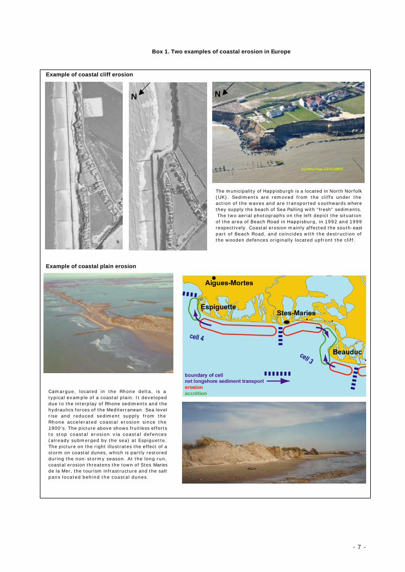
Box 1. Two examples of coastal erosion in Europe
Example of coastal cliff erosion
Example of coastal plain erosion
The municipality of Happisburgh is a located in North Norfolk (UK). Sediments are removed from the cliffs under the action of the waves and are transported s outhwards where they supply the beach of Sea Palling with “fresh” sediments. The two aerial photographs on the left depict the situation of the area of Beach Road in Happisburg, in 1992 and 1999 respectively. Coastal erosion mainly affected the south-eastpart of Beach Road, and coincides with the destruction of the wooden defences originally located upfront the cliff.
N N
Camargue, located in the Rhone delta, is a typical example of a coastal plain. It developed due to the interplay of Rhone sediments and the hydraulics forces of the Mediterranean. Sea level rise and reduced sediment supply from the Rhone accelerated coastal erosion since the 1900’s. The picture above shows fruitless efforts to stop coastal erosion via coastal defences (already submerged by the sea) at Espiguette. The picture on the right illustrates the effect of a storm on coastal dunes, which is partly restored during the non-stormy season. At the long run, coastal erosion threatens the town of Stes Maries de la Mer, the tourism infrastructure and the salt pans located behind the coastal dunes.

- 8 -
FACTORS INFLUENCING COASTAL EROSION
Coastal erosion is usually the result of a combination of factors - both natural and human induced - that operate on different scales. EUROSION has undertaken a review of factors responsible for coastal erosion in about 60 case studies representative of European coastal diversity (see figure 1).
Figure 1. Location of the 60 case studies reviewed during EUROSION study (with average erosion rate per year for selected cases)
Coastal erosion figures depend on time and spatial scales of observation. The sedimentary coastline exists in an environment that is fluctuating over different timescales with periods relating to waves (seconds), tides (twice daily), seasons and longer timescales, as for example changes in sea level. Definition EUROSION defines coastal erosion as the encroachment of land by the sea after averaging over a period which is sufficiently long to eliminate the impacts of weather, storm events and local sediment dynamics (such as “sand waves”). The figures in this report refer to coastline observations at kilometre scale over a time interval in the order of ten years. It is assumed, but not proven, that these figures are representative for the long term trend in coastline position. Coastline fluctuations at time intervals smaller than a
- 9 -
decade or at spatial scales smaller than a kilometre may exceed the trend figures and cause substantial damage. However, no systematic information on these fluctuations is available. The processes responsible for coastal erosion are different for different types of coasts. For cliff coasts erosion is an ongoing process, even in the absence of sea level rise, human interventions or changes in fluvial sediment supply. For sand coasts or mud coasts the situation is different. Here accretional and erosional processes may balance each other and the coastline may appear stable whilst exhibiting an inherent dynamic. In practice this hardly ever occurs, because the balance between accretional and erosional processes is disturbed by sea level rise, uplift or subsidence of land, changes in fluvial sediment supply or by human interventions affecting wave and flow patterns in the coastal zone. Coastal erosion results in three different types of impacts (or risks): Ø loss of land with economical value (such as the beaches of De Haan, Sylt, Mamaia,
Vecchia Pineta, Giardini Naxos, Sable d’Olonnes, Ghajn Tuffieha, Essex, Haute-Normandy) or with ecological value (Scharhoern Island along the Elbe estuary); a specific mechanism is the collapse of properties located on the top of cliffs and dunes (as documented in the cases of South Down, Luccombe, Normandy, Hyllingebjerg – Liseleje, Castellon, Vale do Lobo, and Estela);
Ø Destruction of natural sea defences (usually a dune system) as a result of storm events, which may result in flooding of the hinterland. This risk is best illustrated by the cases of Holland Coast, Western Scheldt, Wadden Sea, Rosslare, Hel peninsula, Sylt, Camargue, Vagueira, and Castellon;
Ø Undermining of artificial sea defences as a result of chronic sediment shortage (relevant examples: Knokke-Zoute, Humber Estuary, Ystad, Chatelaillon, Sable d’Olonne, Donegal, or coastal marsh squeeze such in Elbe and Essex).
These examples show the close relation between coastal erosion and the risk of coastal flooding as in many of the areas the former is followed by the latter. Natural factors causing coastal erosion include: Winds: not just as a generator of waves but also causing landward movement of sediment, usually sand dunes, of the coastal zone (abrasion, or aeolian erosion). This is particularly visible in Aquitaine, Chatelaillon, Rosslare, and Holland; Storms. Damage caused by storm waves does not necessarily contribute to long-term coastal erosion. Irreversible storm-induced erosion occurs at cliff coasts, but not at sand or mud coasts when there is a positive sediment supply; Near-shore currents. Usually generated by tidal currents, near-shore currents involve sediment transport and deposition and erosion along the coast. Erosion by long-shore drift (or transport) is observed in Vale do Lobo, Estela beach, Aquitaine, De Haan, Zeebrugge, Sylt or Jutland. Erosion induced by cross-shore sediment transport is best illustrated with the cases of Sable d’Olonne or Donegal. As for tidal currents, their impact on sediment transport is maximal at the inlets of tidal basins or within estuaries such as in the cases of the Wadden Sea, Arcachon basin, Western Scheldt and the Essex estuaries. In some places, near-shore currents follow complex patterns, like in Estela, Rosslare, and Falsterbo; Vertical land movement, including isostatic rebound, tectonic movement or sediment compaction, may have either a positive of negative impact on coastline evolution. Over the

- 10 -
Holocene epoch (approximately 10,000 years before present), some parts of northern Europe affected by the last glaciation have experienced land uplift (e.g. Baltic sea area and Finland) and despite global sea level rise relative sea levels are falling. Further south particularly around the southern North Sea basin this trend is reversed and there is a rise in relative sea level; Relative sea level rise. As sea level rises relative to the coast the natural tendency is for the coastal habitats to move landwards. When this landward movement is curtailed by rising ground (or artificial structures), the whole profile will attempt to rise with it, which means that extra sediment is needed to build up the profile. This sediment is often taken from the coast. Though more severe in sheltered muddy areas (e.g. Essex estuaries), this phenomenon has been reported as a significant factor of coastal erosion in all regional seas: Atlantic Sea (e.g. Donegal, Rosslare), Mediterranean Sea (e.g. Petite Camargue, Messolongi, Lakkopetra), North Sea (e.g. Holland coast), Baltic Sea (e.g. Gulf of Riga), and Black Sea. Back-barrier basins (like the Wadden Sea) also tend to adapt their depth to changes in mean sea level, creating an additional sediment demand. Back-barrier basins therefore act as sediment traps, which take away sediment from the adjacent shores and aggravate erosion. In the Netherlands this is an important cause of coastal erosion.
Figure 2. Time and space patterns of natural factors of coastal erosion “Distance” reflects the geographical extent within which the factor operates with a relatively constant intensity. “Time” reflects the temporal extent within w hich the factor occurs and causes erosion. Note that waves and tides operate on very short time scales and are often not considered as main causes of erosion.
Slope processes: encompassing a wide range of land-sea interactions which eventually result in the collapse, slippage, or toppling of coastal cliff blocks. These processes involve on the one hand terrestrial processes such as rainfall and water seepage and soil weathering (including alternating freeze/thaw periods), and on the other hand the undercutting of cliff base by waves. The cases of Luccombe, Birling Gap, Criel-sur-Mer (Normandy), Sylt, Cova do Vapor (slope processes only), Vale do Lobo are particularly relevant in that respect.
- 11 -
Human induced factors of coastal erosion include: Coastal engineering: the waterfronts of urban, tourism or industrial zones have usually been engineered by way of seawalls, dykes, breakwaters, jetties, or any hard and rock-armoured structures, which aims at protecting the construction or other assets landwards the coastline from the assault of the sea. Such structures modify wave and flow patterns in the near shore zone and therefore cause a redistribution of sediment. The net sediment volume in the coastal zone may not be strongly affected, but the sediment redistribution can induce erosion in some places and accretion in others. Modification of wave and flow patterns and coastal sediment transport are related, inter alia, to:
(i) Trapping of sediment transported alongshore and a sediment deficit downdrift due to the fact that unlike “natural” coastlines, hard structures do not provide sediment for the longshore drift. (Examples are mainly harbour and marina protection structures such as those of Brighton - Sussex, Aveiro - Vagueira case and Vilamora - Vale do Lobo, Rosslare, IJmuiden - Holland, Zeebrugge, Skanor – Falsterbo, Messina or by groins such as those of Ystad, Jutland, Quarteira - Vale do Lobo, Vagueira, Estela, Marina di Massa, and Hel Peninsula);
(ii) Incoming wave reflection by hard structures that hampers energy dissipation and augments turbulence resulting in increased cross-shore erosion. Vertical seawalls and bulkheads increase this phenomenon leading to more offshore erosion undermining the constructions. Examples are found in Chatelaillon and Sable d’Olonne;
(iii) Wave diffraction, which is the alteration of the wave crest direction due to the vicinity of seaward structures (such as jetties or breakwaters). This alteration results in wave energy being either diluted in some places (less impact on the coastline) or concentrated in others (more impact on the coastline and subsequent erosion). Note that in the case of Playa Gross, wave diffraction induced by a semicircular breakwater is used as part of the coastal erosion management solution.
Land claim. The impact of land enclosure projects undertaken in the 19th and first half of the 20th century on coastal erosion has only become obvious in the last few decades. Within tidal basins or bays (where land reclamation projects are most easily undertaken), land reclamation results in a reduction of the tidal volume and therefore a change in the ebb and flood currents transporting sediments. As a result, relatively stable coastal stretches may begin to erode. Land reclamation projects undertaken in Rosslare (in 1845 and 1855 provides a good illustration of this phenomenon). Land reclamation in the Wadden Sea has also caused a significant reduction of the sand banks in the outer delta. For land reclamation projects undertaken along open coasts, (e.g. Holland coast) changes in coastal processes do not occur as a result of tidal volume reduction but as a result of changes in the coastline geometry and wave-breaking angles.
River basin regulation works. As for land enclosure, the impact of water flow regulation works on coastal processes has been highlighted only recently; probably such impacts become visible only after several decades. Damming has effectively sealed water catchments locking up millions of cubic metres of sediments per year. For some southern European rivers (e.g. Ebro, Douro, Urumea, Rhone), the annual volume of sediment discharge represents less than 10% of their level of 1950; for the Ebro this is even less than 5%. This results in a considerable sediment deficit at the river mouth, and subsequent erosion downstream as illustrated in Ebro delta, Playa Gross, Petite Camargue (Rhone delta) and Vagueira. In addition to river damming,

- 12 -
any activity, which results in a reduction of the water flow or prevents river flooding (as a major generator of sediments in the water system) is expected to reduce the volume of sediments reaching the coast.. Dredging. Dredging activities have intensified in the past 20 years for navigational purposes (the need to keep the shipping routes at an increasing water depth). For construction purposes sand and gravel is often extracted from the seabed and since the 1990’s for beach and underwater nourishment. Dredging may affect coastal processes in two ways:
(i) by removing from the foreshore materials (stones, pebbles) which protect the coast against erosion. For instance, stone fishing in Hyllingebjerg-Liseleje triggered structural erosion. By way of illustration, it is estimated that 50% of the total volume of the protective pebbles (3 million cubic meters) has been extracted from the chalk cliff of Normandy since the early 1900’s;
(ii) by contributing to the sediment deficit in the coastal sediment cell, such as in the Humber estuary, the coast of Sussex for construction purposes (extraction of sand, gravel and shingle for navigational purposes, Cova do Vapor, where sand has been dredged (too close to the coast) to supply materials for the beaches of Costa del Sol, and in Marinell di Sarzana and Marina di Ravenna – Lido Adriano, where dredging from river beds took place (this only happens if sediment is taken from areas which tend to morphologic equilibrium, i.e. a narrow coastal strip and inland basins).
Vegetation clearing. A significant number of cases have highlighted the positive role of vegetation to increase the resistance to erosion - e.g. Aquitaine and the Baltic States: Gulf of Riga, Klaipeda, Tallinn. With the same idea, changes of land use and land cover patterns, which tend to reduce the vegetation cover on the top of cliffs may increase infiltration of water and undermine the cliff stability. This is best illustrated by the example of the golf courses of Vale do Lobo where irrigation may have had an impact. Gas mining or water extraction. A few examples illustrate the effect of gas mining or water extraction on land subsidence (Dutch Wadden Sea). The impacts are irreversible. In Marina di Ravenna – Lido Adriano the land subsides nearly a meter over the last 50 years, causing a major sediment deficit and a strong retreat of the coastline.
- 13 -
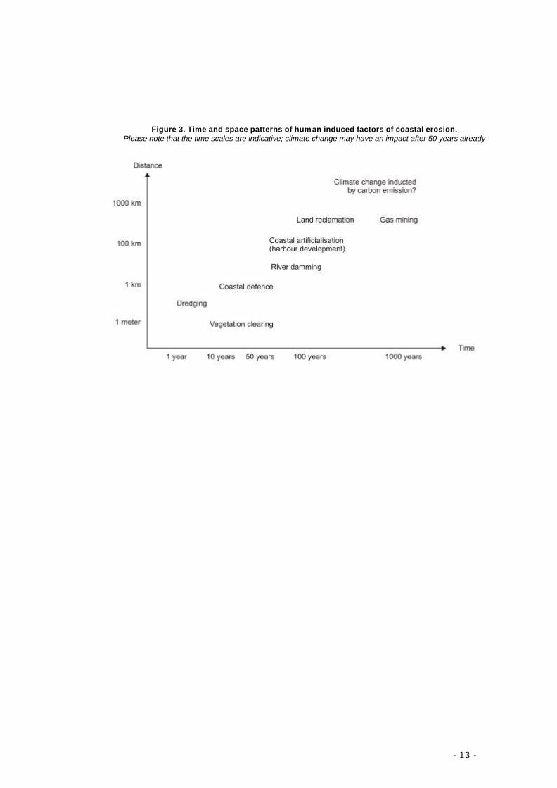
Figure 3. Time and space patterns of human induced factors of coastal erosion. Please note that the time scales are indicative; climate change may have an impact after 50 years already

- 14 -
MAJOR FINDINGS
The EUROSION studies have resulted into the following findings:
Finding 1: on coastal squeeze and the loss of sediment Urbanisation of the coast has turned coastal erosion from a natural phenomenon into a problem of growing intensity. In many coastal areas erosion problems are now increased by human activities and artificially stabilised seafronts are progressively encroaching on sedimentary coastlines and cliffs. Dynamic ecosystems and their undeveloped coastal landscapes are gradually disappearing, and lack of sediment can be a major contributory factor. In many places ‘coastal squeeze’ is the manifestation of this phenomenon.
Coastal squeeze The combined effect of coastal erosion, infrastructure development and the erection of defences to protect them have created, in many areas, a narrow coastal zone. “Coastal squeeze” occurs especially in low-lying and inter-tidal areas, which would naturally adjust to the changes in sea level, storms and tides, but cannot do so due to the construction of inflexible barriers such as roads, dykes, urbanisations, leisure parks, industrial and other facilities. This causes a direct loss of natural habitats. In areas where relative sea level is rising or where sediment availability is reduced, there is a further coastal squeeze resulting from a steepening beach profile and foreshortening of the seaward zones as illustrated in figure 4. Figure 4. A simple illustration of ‘Coastal squeeze’. Habitats are lost as a result of land claim, sea level rise or
reduction in sediment availability
In spite of coastal erosion problems and the increasing impacts of ‘coastal squeeze’ on the ability of the coast to sustain human use, development pressures on the coast have not abated. The building of protective structures is still widely practised, threatening natural resources. This will result in further reduction in the space available at the coastal margin both for human activity, the protection afforded by naturally functioning coastal systems and the sustainable exploitation of the natural resource.
- 15 -
Finding 2: on environmental and economic assessment
Environmental Impact Assessment (EIA) procedures - as implemented under the terms of the directive 85/337/EEC – have been insufficient in addressing the impact of human activities, such as development, on the wider coastal environment. Subsequently, the cost of attempting to reduce coastal erosion has increased considerably in relation to the assets requiring protection. Consequently it has resulted in a need to transfer the cost of coastal erosion mitigation measures to such activities. In spite of clear evidence that human activities can increase coastal erosion, the EUROSION case studies demonstrate that Environmental Impact Assessment (EIA) procedures have not been able to contain the extent of coastal erosion. This is consistent with the analysis of Europe-wide data collected by EUROSION at scale 1:100,000 which demonstrate that 63% of the 875 newly eroding kilometres5 of coastline (i.e. eroding in 2001 but not eroding in 1986) are located less than 30 kilometres from an engineered frontage, like a harbour or urban seafront. The reasons for this are multiple:
• Considerable interventions affecting coastal erosion processes have taken place since the 1900’s (1950’s in the case of river damming), that is to say well before the existence of EIA regulations in Europe (in general in the 1980’s). Many of these investments are still “active” in disturbing sediment transport processes. River basin regulation works, which disrupt the transport of coarse river sediments to the sea, cause an annual sediment deficit estimated at 100 million tons (source: derived from EUROSION database);
• Coastal erosion results from the cumulative impact of a wide range of natural and human-
induced factors, none of which may be considered as the single cause for erosion. This is true for dams (each dam perhaps only trapping a small proportion of total sediments); and for other projects related to industrial development, tourism (marinas, seafront rehabilitation), urbanisation, sand mining and dredging, and coastal protection itself. In case an EIA is required for such projects, experience has shown that their individual impact on coastal erosion may not be significant enough to justify the integration of coastal sediment transport in the EIA;
• Large size projects, such as harbour extensions (e.g. Maasvlakte in Holland coast,
Aveiro), land reclamation for creating wind parks (e.g. Wadden Sea and Schleswig Holstein), or energy production plant (e.g. Paluel and Penly in Normandy) do address coastal erosion processes within the framework of their EIA. However, it is quite common that the cost of mitigation measures exceed the willingness - or the capacity - of the project developer to pay for it. This is best illustrated by the case of Aveiro where the cost of annual sand by-passing (5 millions euros) has been deemed excessive by the harbour authorities;
• EIA procedures are not systematically applied to small and medium size projects, though
they may, when taken together, exacerbate coastal erosion.
5 The figure 875 kilometres only reflects a small part of the EU coastline: it concerns “proven” changes in evolutionary
trends (many data observed in 1986 were not certain) and those sections of the coastline covered in 1986 (EU12)

- 16 -
• Current national legislation on EIA do not prescribe any clear rules for public hearings, i.e. for communicating to and cooperating with local stakeholders, when establishing an EIA. In a number of countries (notably Italy, Portugal, Cyprus and Spain) EIA reports are released for comments to the public at a very late stage of project development and only for a short period. This was found to considerably hamper the integration of local "knowledge" on potential environmental damage – including damage due to coastal erosion - in project design;
The consequences of EIA limitations in addressing coastal erosion properly result in a significant increase of costs (or at least risks) for society, in terms of habitat loss, loss of public facilities and invested capital, cost of mitigation measures.
Finding 3: on coastal erosion risk The cost of reducing coastal erosion risk is mainly supported by national or regional budgets, hardly ever by the local community and almost never by the owners of assets at risk or by the party responsible for coastal erosion. This is emphasized by the fact that coastal erosion risk assessment has not been incorporated in decision-making processes at the local level and risk information to the public remains poor. The risk of erosion (and flooding) at a particular location is the result of the probability (frequency) of coastal erosion events and of the impacts (capital investment or population in the risk zone). Current practices observed in Europe reveal that the tax payer – through expenditures executed by public authorities - supports the major part of the costs associated with coastal erosion risk. Almost no cases are found were the parties responsible for coastal erosion or the owners of assets at risk paid the bill. As mentioned before, public expenditure dedicated to coastline protection against the risk of erosion and flooding has reached an estimated 3,200 million euros in 2001. This amount covers both new investments made in 2001 (53%), costs for maintaining existing protection schemes and monitoring the coastline (38%) and provision for purchasing coastal lands at risk (9%) . Though little data exists on the contribution of private funding for coastal erosion management in European member states, it is highly probable that this contribution does not reach 10% of the public expenditure. Of the case studies reviewed, only Denmark showed a significant contribution from private owners, in this case reaching up to 50% of the overall cost of coastal defence. The contribution of the private sector to the costs of coastal erosion management is not seen by private entrepreneurs as their responsibility but as an opportunity. In this case to receive a direct benefit from coastal erosion management programmes, such as beach extension (Vale do Lobo, Vecchia Pineta), increased sand quality (Sable d’Olonne) or increased market values of the backshore (Playa Gross). Only authorities of medium-to-large size harbours contribute significantly to works to mitigate the impact of their activities on coastal erosion.. Observations made at the local level make it possible to classify the behaviour governing investment at risk along the coast. Such behaviour includes:
• An underestimation of hazard probability. Some individuals may perceive the probability that damage caused to their property by coastal erosion is not sufficiently high to alter the decision to build or move to an alternative location. In practice, a majority of private owners having experienced such damage report their lack of knowledge about the risks
- 17 -
beforehand ( “I wish I had known…”) as illustrated in the cases of Sussex, Isle of Wight, Normandy, Cap Ferret, Jutland, Sylt, Ravenna, and Vagueira, and often blame the authorities that have allowed such investments. The lack of knowledge about the risk is also commonly found at the level of local authorities, who themselves may regret their lack of means to appropriately inform their citizens. Only a few countries have institutionalized the assessment of risks. The “Barnier Act” (adopted in 1995) stipulates elaboration of risk maps for the whole of France at the level of municipalities. So far (by 2002) only 3,000 out of the 36,000 French municipalities have been provided with such risk maps. Even where they exist they are not made readily accessible to the public;
• Short term horizons. Individuals and investors may have relatively short time horizons
during which they want to recover their investment. Even if the expected life of the house is 40 or 50 years, the investor may only look at the potential benefits of his/her investment over the next 8 to 10 years before resale. They may reason that they will not be residing in the property for longer than this period of time. This way of thinking has prevailed along the Mediterranean coast, where the profit return period in the tourism sector generally does not exceed 10 years, as epitomized in the cases of Sitges, Can Picafort, Vecchia Pineta, Procida, Giardini, Mamaia, and Larnaca;
• Expectation of public assistance. Individuals may have little interest in considering the risk
level if they believe that they will be financially responsible for only a small portion of their losses should a hazard occur. In that respect, common practice in most European countries has largely shown this belief to be well founded. The examples of Sussex, Sable d’Olonne, Lacanau, Saintes-Marie, Castellon, Estela, and Vale do Lobo are illustrative of the way public policy and funding is directed to threatened property owners and by the empathy their situation generates in the public at large. In a few cases, best illustrated by the example of Cap Ferret, public authorities are even held responsible for damage induced by coastal erosion because they granted construction permits in areas at risk.
The use of public monies to safeguard the safety of people and economic infrastructure does not pose a problem as such. However, it may be questionable whether public authorities should bare the financial cost when others are responsible for coastal erosion or where owners choose to live within areas at risk. The opportunity to place the onus for coastal defence in these circumstances on the beneficiaries (the “polluter pays” principle) and investments at risk must therefore be considered.
Finding 4: on the mitigation of coastal erosion Over the past hundred years the limited knowledge of coastal sediment transport processes at the local authority level has often resulted in inappropriate measures of coastal erosion mitigation. In many cases, measures may have solved coastal erosion locally but have exacerbated coastal erosi on problems at other locations – up to tens of kilometres away – or have generated other environmental problems. As of 2001, about 7600 kilometres benefited from coastal erosion mitigation schemes, and 80% of these schemes have been in place for more than 15 years. Such mitigation schemes use and combine a wide range of techniques (see table 4 of part II) and approaches which include:
- 18 -
• hard engineering techniques, i.e. using permanent concrete and rock constructions to “fix” the coastline and protect the assets located behind. These techniques - seawalls, groins, detached breakwaters, groins, or revetments - represent a significant share of protected shoreline in Europe (more than 70%);
• soft engineering techniques (e.g. sand nourishments), building with natural processes
and relying on natural elements such as sands, dunes, marshes and vegetation to prevent erosive forces from reaching the backshore;
• Realignment of assets, consisting in removing or abandoning houses and other
constructions from the erosion-prone areas. Case studies reviewed by EUROSION have provided a range of experiences in relation to the cost-effectiveness and environmental friendliness of such protection schemes. Major lessons learnt from these are:
• Lessons learnt from hard protection techniques. Many hard constructions have had only positive effects in a short time and space perspective. By disrupting long-shore drift of sediment transport, beaches located further down-drift of hard constructions in many cases have been deprived of sediment and as a result suffered from increased erosion. Vertical constructions such as seawalls and bulkheads also increase turbulence and sediment scouring, which help to undermine their own foundations. Particularly illustrative of this are the seawalls of Playa Gross (built in 1900), Chatelaillon (1925), or De Haan (1930), which still continue to exacerbate erosion problems. Groins can be effective for a limited length of coastal, but on the down-drift side erosion often necessitates an extension of the groin-field, resulting into a “domino” effect. This is illustrated by the example of Hel Peninsula where within a couple of decades a complete groin field was created over a distance of 12 km. Hard engineering also proved to have limited efficiency in the case of protected cliffs, such as those of Ventnor on the Isle of Wight and in Sussex. Here slumping of soft rock cliffs is the result of terrestrial processes such soil weathering (through water seepage), lubrication between geological layers and erosion by rainwater along streams and gullies and does not just originate as a result of wave attack.
• Lessons learnt from soft protection techniques. Dune, beach and near shore sand
nourishments have aroused a considerable interest in the past 20 years. The enthusiasm generated lies in its ability to contribute positively to safety as well as to other functions such as recreational use, water purification (in dunes) and ecological values. In the case of the Netherlands, systematic dune, beach and foreshore nourishment has been successfully applied since 1990, after a period of 20 years of sand nourishment experiments. Today it constitutes the backbone of the Dutch shoreline management policy and can be considered successful for three reasons:
1. it is proven as an efficient safety measure; 2. it is cost effective; and 3. it provides opportunities for other coastal functional uses.
Systematic monitoring of coastal (terrestrial and near shore marine) profiles is also required in order to determine for each coastal cell how long the sand supplied will endure. The life span of the sand nourishment operation is and important input parameter for CAB analyses. Frequent monitoring is prerequisite for effective coastal protection and provides the basis for
- 19 -
cost-benefit analyses. Less convincing examples (where these requirements were not met and sand nourishments were executed with only a limited knowledge of coastal hydraulics) are:
• the case of Vale do Lobo where 700,000 cubic metres and 3.2 million euros of investment have been washed away by long-shore drift within a few weeks;
• the case of Ebro delta where the sediment volume needed was taken from far away and not subjected to a rational cost-benefit analysis;
• the case of Sitges where dredging of sand is held responsible for irreversible damage to sea grass communities (Posidonia), which was not subjected to an EIA.
• Lessons learnt from managed realignment. Since the early 1990’s, a new approach to
address coastal erosion has developed in Europe and consists in abandoning lands at risk and relocating the assets further inland. Such an approach has been implemented in the UK (notably Essex and Sussex) and France (notably Criel sur Mer). The rationale for this is twofold;
- cost benefit analysis which has demonstrated that the cost of protection largely exceeds the value of assets to be protected in the long term (over the life expectancy of the assets). The cost of protecting eroding cliffs – ranging from 1 to 5 M€ according the type of cliffs and protection for a typical 10 year period – and hosting 10 to 15 houses of 100 to 200,000 euros each at market value may not seem reasonable from a economical point of view;
- coastal erosion may be needed to provide sediments further down-drift (depending on their social, economic or ecological value).
In accompanying managed realignment, the question of “compensation” has to be considered as crucial to ensure acceptance of solutions, which can be quite unpopular with the local population. Failure to provide a fair basis for compensation – based for example on the “risk”-less market value, instead of the actual market value “with risk” – may result in strong resistance from the population and conflict with authorities.
These experiences demonstrate the limits of piecemeal responses to coastal erosion and demonstrate the need for the adoption of a proactive approach based on planning, monitoring and evaluation and ICZM principles. The same examples also provide an indication of the key factors in the success for such a wider approach. Major among these factors are:
• A good understanding of coastal sediment transport processes within the “sediment cell” the eroding area belongs to. A coastal sediment cell can be defined as a length of coastline and associated near-shore areas where movement of sediments is largely self contained. Sediment cells are separated from each other by rivers and sometimes by large promontories where the direction of longshore drift is changing; the length of sediment cells may be very small (less than a kilometre) or very large (100 km). In practice, this means that measures taken within a specific sediment cell may have an impact of other sections of the same sediment cell but will not significantly impact adjacent cells. This understanding may help reject some technical options and assess the impact of suitable options down-drift;
• A combination of instruments. It cannot be concluded from existing experience that hard
engineering is “bad” and soft engineering is “good” or vice-versa. In this sense, no miracle solution can be prescribed and each situation is different from another. Most successful strategies have tried to balance the urgent need to stop erosion in a particular place,, the long term value of working with natural processes with an acceptance that some lands will be inevitably lost;

- 20 -
• Research of multi-functional designs through a broad participation of all stakeholders.
Seeking technical solutions, which fulfil more than the function of safety is undeniably a major asset to make coastal erosion mitigation solutions more viable financially (by encouraging co-funding), but also socially more acceptable. The following objectives have also been found to benefit in Europe from the development of wide coastline management strategies: - Better access to harbour facilities by dredging beach nourishment materials in
navigational channels (Western Scheldt); - Protection of fresh water lenses against salt water intrusion in fertile coastal plains
(Aveiro, Ebro, Holland); - Revaluation of the property market value induced by risk reduction (Playa Gross); - Increase in beach use induced by the foreshore extension (Sitges, Marina di
Massa, Giardini, Vecchia Pineta), dry sand (Sable d’Olonne), or modification of plunging characteristics of breaking waves (Playa Gross);
- Rehabilitation of natural areas and associated biodiversity (Aquitaine, Koge Bay); - Provision of shelters for fishermen’s boats (Dolos Kiti, Shabla Krapetz); - Absorption of nitrogen’s by coastal marshes initially designed for coastal defence.
• A thorough assessment of costs and benefits. Cost benefit analysis provides the basis for identifying technical solutions that are financially viable and affordable. When rigorously conducted and by adopting a broad time horizon (e.g. 50 years) and spatial scale (the sediment cell), such analysis also helps identify external environmental costs. In turn these may provide further incentives to adopt managed realignment or simply “doing nothing” instead of erosion control measures.

- 21 -
Finding 5: on information management
In spite of the availability of a tremendous amount of data, information gaps continue to exist. The practice of coastal information management – from raw data acquisition to aggregated information dissemination - suffer from major shortcomings, which result in inadequate decisions. Surprisingly, sharing and dissemination of coastal data, information, knowledge and experiences are hardly ever considered by regional and local stakeholders. The use of a better knowledge base when coastal development is proposed provides an opportunity, which would reduce technical and environmental costs of human activities (including measures for coastal erosion mitigation) and could help anticipate future trends and risks. In spite of its importance for supporting decision-making, information is generally not seen by public authorities in charge of coastline management as a strategic sector, which justifies major investments. This does not necessarily mean that the budget dedicated to data collection and analysis should be increased – it already reaches between 10 and 20% of all expenses related to coastal erosion management within the cases reviewed (between 320 and 640 M€ extrapolated to all Europe). Instead, it suggests that authorities are reluctant to conduct the appropriate reforms in the fields of information management. Reforms would make it possible at the long run to: (i) increase the cost-effectiveness of decisions made in the fields coastline management and, (ii) to reduce and optimise the expenditures related to coastal data production and processing. Yet, evidence shows that inadequate use of existing information has been responsible for considerable economic losses in Europe during the period 1995-2002 as illustrated by the case of Vale do Lobo or Lacanau-Cap Ferret Although a wide range of stakeholders are involved in coastline management at all levels, the information needs are quite similar for most of these stakeholders and most of European regions surveyed by EUROSION, and can be summarised as follows:
• the impact of human activities on coastal sediment transport processes, which would make it possible to optimise the selection of suitable sites for investments and/or to establish environmental liabilities;
• the delineation of areas at risk of coastal erosion for the coming years, which would make it possible to prioritise coastal erosion mitigation measures and control urban development;
• the long term costs and benefits of coastal erosion mitigation measures, which would make it possible to select the most cost-effective scenario and if needed propose areas where retreat should be managed.
Paradoxically, these information gaps contrast with the tremendous amount of data available on near-shore areas (data being defined here as a "collection of raw measurements and observations not collated into meaningful information"). This suggests that information gaps mainly originate as a result of organisational and institutional shortcomings rather than technological limitations. Investigations carried out by EUROSION in the cases of Aquitaine, Catalunya, Isle of Wight, Essex, Aveiro, and North-Holland largely confirm this conclusion and have identified a number of shortcomings in coastal information management practices, which can be summarized as follows:
- fragmentation of data repositories and host institutions. This aspect is all the more critical since rigorous risk and impact assessment, as well as land use planning in
- 22 -
coastal zones requires a wide variety of information involving many issues, wide time horizon and spatial scales. These include wave and wind climate, tidal regime, near-shore current patterns, history of extreme water elevations, coastal geology and geomorphology, sedimentary properties of the seabed, terrestrial and marine topography, land use, and land tenure. Investigations carried out by EUROSION revealed that the complete collection of such data involves 9 institutions in the case of Aquitaine and Catalunya, 6 for Isle of Wight and Essex and Aveiro, and 5 along the Holland coast. Each host institution uses (in general) its own standards, which significantly increases the costs for making the data interoperable and the delays for retrieving data.
- duplication of data production efforts. In a significant number of cases, similar datasets
have been collated by different institutions resulting in a considerable duplication of data acquisition costs. This has been observed in the case of North-Holland and Aveiro, and to a lesser extent in Catalunya and Isle of Wight. In the specific cases, far from being isolated, the costs that could have been avoided are significant if proper coordination mechanisms existed. But lack of coordination does not explain everything: excessive access fees to existing data sources combined with restrictive copyrights have also led various stakeholders to develop their own datasets as is reported in the case of Catalunya and the Isle of Wight.
- reluctance to release key information. Poor access to documents or datasets
considered important to decision making is reported by the vast majority of the local stakeholders interviewed. Often the reluctance of the information producer to release his/her information has resulted in misunderstandings and conflict. These feelings, which may be exaggerated in some cases (see next point), can be verified for example in relation to requests for Environmental Impact Assessment (EIA) reports. Here the experience of the EUROSION team, who made 78 requests for EIA studies in 11 European regions, suffered 71 refusals (see also Finding 2). Surprisingly, such documents had been cleared by public authorities and were meant to be accessible.
- poor archiving and dissemination capacities. Poor access to existing documents and
datasets can come from a reluctance to release such information by individual organisations. Delays in accessing information also originate because of the lack of clearly established dissemination mechanisms such as information resource centres, virtual libraries, or simply contact persons for each existing datasets or documents. With the notable exception of governmental bodies in charge of producing and diffusing baseline data over the whole national territory – e.g. national geological surveys, national meteorological centers, national mapping agencies, hydrographical offices and river basin agencies – other institutions produce data largely for their own purposes (be it research or management oriented) and not for external users. Extending their mandate to data dissemination would require rethinking organisational issues, defining data diffusion policies and most of all identifying the economical incentives which are currently not well perceived by the data producers (especially public funded producers).
The above mentioned shortcomings are emphasized by the fact that, contrary to other sectors (e.g. coastal defence, land-use planning, water management), the sector of coastal information management does not clearly fall under the responsibility of any of the institutions existing at the national or local level. This administrative vacuum also jeopardizes the emergence of a long term vision to overcome these shortcomings.
- 23 -
THE EUROSION VISION
Understanding the dynamic nature of the coastal margin is a key factor in managing coastal erosion. Human populations have always tended to favour settlement along the coastal margin. In historical times these were largely at the mercy of the forces of nature. From Roman Times onwards coastal defences have been built to protect ‘new land’ created during periods of relative sea level fall or when an increased sediment supply resulted in shoreline accretion. Structures such as sea walls and groyne fields have not only helped to sustain these lands from erosion and flooding, but also provided the impetus for more coastal land to be developed. This has in turn resulted in a sometimes dramatic loss of habitats (especially coastal dunes, beaches, intertidal saltmarshes and sand and mud flats and seagrass beds) and with them a reduction in their natural dynamic characteristics.
EUROSION has shown that whilst protection is possible, extreme events undermine and/or overtop coastal defences locally. Long term trends and knock-on effects from the structures themselves can also result in negative effects on the resilience of much larger coastal units. It is anticipated that this situation will be aggravated by rising sea levels and a more unpredictable and extreme storm climate associated with climate change. This will result in a long term threat to the safety of people, the sustainability of many coastal activities, coastal biodiversity (including Natura 2000 sites) and the ability of the coast to provide a ‘natural’ coastal defence. In extreme situations the coastal margin can disappear altogether (see figure opposite). In this context the maintenance of artificial shorelines made by enclosing intertidal zone or to protect infrastructure and the justification for maintaining defences in such locations needs to be re-examined.
Coastal resilience
EUROSION recognises the sustainable development of coastal zones and the conservation of dynamic habitats, especially on the remaining undeveloped coast, as important long term goals for European coastal zones. This requires a respect for, and in many cases restoration of, the natural functioning of the coastal system and hence its natural resilience to erosion. EUROSION defines coastal resilience as the inherent ability of the coast to accommodate changes induced by sea level rise, extreme events and occasional human impacts, whilst maintaining the functions fulfilled by the coastal system in the longer term. The concept of resilience is particularly important in the light of the predictions for climate change.
The implications of the resilience concept varies depending on the coastal type. For hard rock coasts resilience may not be considered critical because the rocks are resistant to erosion. In the case of active cliffs (bluffs), allowing retreat of the cliff edge will contribute to an increase of the sediment volume contributing to the resistance of the cliffs themselves and to adjacent shorelines; this will leave the resilience of the wider system intact.
In the case of sedimentary coastlines, resilience is usually based upon the maintenance of the sediment balance. Two key factors can be identified in determining whether sensitive (‘soft/dynamic’) coastal systems are inherently resilient or not:
1. local availability of sediments in sufficient quantity to sustain the dynamic equilibrium between erosion and accretion and attaining a ‘favourable sediment status’. Chronic losses of sediments will lead to an increase in the balance of erosion over accretion and ultimately in a loss of habitat and narrowing of the shoreline;
- 24 -
2. space for coastal processes to operate. Limitations on the space available to accommodate the natural retreat of cliffs and sedimentary habitats and/or the redistribution of sediments as a result of this retreat will decrease coastal resilience.
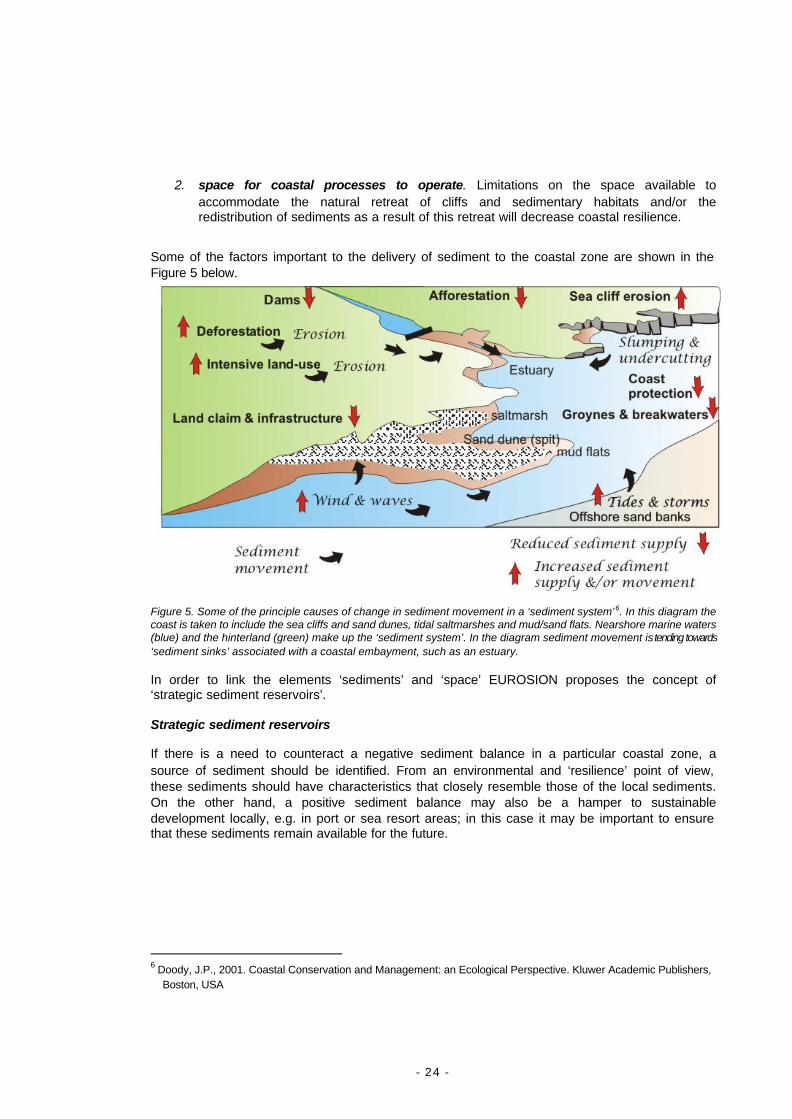
Some of the factors important to the delivery of sediment to the coastal zone are shown in the Figure 5 below.
Figure 5. Some of the principle causes of change in sediment movement in a ‘sediment system’6. In this diagram the coast is taken to include the sea cliffs and sand dunes, tidal saltmarshes and mud/sand flats. Nearshore marine waters (blue) and the hinterland (green) make up the ‘sediment system’. In the diagram sediment movement is tending towards ‘sediment sinks’ associated with a coastal embayment, such as an estuary.
In order to link the elements ‘sediments’ and ‘space’ EUROSION proposes the concept of ‘strategic sediment reservoirs’.
Strategic sediment reservoirs
If there is a need to counteract a negative sediment balance in a particular coastal zone, a source of sediment should be identified. From an environmental and ‘resilience’ point of view, these sediments should have characteristics that closely resemble those of the local sediments. On the other hand, a positive sediment balance may also be a hamper to sustainable development locally, e.g. in port or sea resort areas; in this case it may be important to ensure that these sediments remain available for the future.
6 Doody, J.P., 2001. Coastal Conservation and Management: an Ecological Perspective. Kluwer Academic Publishers,
Boston, USA

- 25 -
To facilitate the future availability of such ‘appropriate’ sediments through planning, EUROSION proposes the concept of ‘strategic sediment reservoirs’, to be defined as: amounts of sediment of ‘appropriate’ characteristics that are kept available for future replenishment of the coastal zone, either temporarily (to compensate for losses due to extreme storms) or in the long term (at least 100 years). They can be identified:
Ø offshore: sands on the sea bed; Ø in the coastal zone; eroding cliffs can be considered sediment reservoirs if natural
erosion processes can be allowed in the future; but also underwater sediments (supporting dunes and beaches) and less valuable agricultural land may be considered;
Ø in the hinterland, preferably within the same catchment area; this latter option is to be considered if insufficient sediment reserves are available within a coastal cell.
The identification, designation and use of strategic sediment reservoirs should be subject to environmental impact assessment (cf. EUROSION Recommendation nr. 2) and to the requirements of accountability (cf. EUROSION Recommendation nr. 3). After designation, the availability of sediment reservoirs should be ensured by leaving them undeveloped.
Major concerns: what is at stake?
For the next 50 years, EUROSION is particularly concerned about the following trends:
- Loss of sediment. The amount of sediments will continue to be at risk due to ongoing trends in river regulation works (including the Ebro hydrological plan), coastal urbanisation, dredging, enclosure of tidal land, loss of vegetation, golf course development on dunes, sand mining and offshore sediment extraction.
- Loss of dynamic coastlines end natural habitats. Sedimentary habitats are often used as sources of sediments to compensate chronic losses of sediments due to human interventions. The response of public policy and funding is mainly driven by property owners in trouble and by the empathy their situation generates in the public; with limited funding the erosion habitats will be lowest on the political list, as there will always be reference to ‘erosion as a natural process’. However, when a coastal zone is designated to provide the space for natural habitats or species, this function may be impacted if this zone is used as a long-term source of sediments, which may also be depleted in the end.
- Loss of resilience. The safety of people and the protection of economic assets and coastal biodiversity are likely to be more easily secured in coastal areas with a high degree of resilience. Unacceptable losses can be avoided by a timely incorporation of risks into planning and development, by making shoreline management accountable and sustainable and by improving its information base.
- Climate change. Climate change scenarios predict an accelerated sea level rise, a more unpredictable storm regime and more extreme events. This can not be avoided for the next 50 or perhaps even 100 years, because measures to counteract the greenhouse effect will only be effective on a longer term. However, the more measures are postponed, the more serious will be the risks to safety, economic assets and biodiversity. Therefore, it is still of fundamental importance to continue giving due attention to climate policies.
- 26 -
Apart from hazards and risks that tend to be unpredictable, coastal erosion will result in an increasing cost to society:
- increasing risk to lives and economic assets. More coastal communities will face similar problems to those that Happisburgh, UK (Box 1, p.7) has been facing over the last 20 years. However, even these problems will be relatively small when compared to the possible impact of failing coastal defences more generally. The combined effect of climate change and a loss of coastal resilience will bring more serious risks to low-lying coastal plains. When sediments are depleted, space for coastal processes lost and when sea levels rise, the risk of flooding in extreme storm events may be severe. This could have catastrophic impacts in East Anglia (England), the Netherlands, NW-Germany, several Portuguese rias and estuaries, Ebro Delta, Languedoc-Roussillon and Camargue, or Venice.
The Global Vulnerability Assessment (carried out for the UN-IPCC) estimated that as a result of sea level rise the annual number of victims of actual coastal erosion or flooding will reach 158,000 in 2020, while half of Europe’s coastal wetlands is expected to disappear.7
- more habitat loss. It can be expected that considerable areas of coastal dunes and wetlands will disappear and with them natural vegetation and species. The social, economic and ecological functions fulfilled by these areas will also disappear. Destruction of dunes is expected to pose threats to fresh water aquifers while salt water intrudes in coastal plains. Finally, the natural ability of wetlands to absorb nitrogen and metals discharged by rivers could be undermined with the risk of accelerating eutrophication of coastal waters.
The Global Vulnerability Assessment has estimated that the loss of European coastal wetlands due to sea level rise would exceed 4,500 km² by 2020, which corresponds to 51% of coastal wetlands in 1990.8
- more mitigation and management cost. With the current trend, the extent of coastline protected by coastal defence would exceed 10,000 kilometres by 2020 while the length of eroding coastlines will not substantially decrease. This will lead to increasing investment and management cost, while mismanagement can even lead to substantially higher cost.
The Global Vulnerability Assessment estimated that the coastal protection cost for European coastal states between 1990 and 2020 would exceed 120,000 million euro, with an additional (indirect) cost of over 41,000 million euro. Total cost of coastal erosion for the period would add up to over 161,000 million euro, corresponding to an average of 5,400 million euro per year.9
7 Salman et al, Coastal Erosion Policies: Defining the issues. EUROSION Scoping Study, 2002. Figures derived from
the Global Vulnerability Assessment. WL Delft Hydraulics / Rijkswaterstaat, 1993.
8 idem.
9 Salman et al, Coastal Erosion Policies: Defining the issues. EUROSION Scoping Study, 2002. Figures derived from the Global Vulnerability Assessment. WL Delft Hydraulics / Rijkswaterstaat, 1993.

- 27 -
The European dimension
Apart from the European monitoring programmes of CORINE and the EEA, the issue of coastal erosion management has not been recognised as a key issue to be dealt with at community level until the European Commission Strategy for ICZM (2000). This strategy refers to the importance of coastal erosion both to sustainable development and as an issue to be incorporated in ICZM responses. The Members of European Parliament taking the initiative of a budget amendment in 2001 have provided a second indication that the issue is recognised as a concern at the European level. Apart from this there are two main reasons why coastal erosion needs to be addressed at Community level:
1. The community dimension of sediments and soils: sediments that are important for future coastal resilience are sealed within water catchments that are to a large extent covering several Member States. River regulation works have impacts on coastal zones of other Member States. The Water Framework Directive is an important instrument in which this can be addressed; an EU soil policy may provide further instruments. In addition, sediments also cross borders in the coastal zone. The sedimentary systems of Nord-Pas de Calais (France), Belgium and the Netherlands are closely related and coastal management actions can easily have cross-border impacts, not only along the beaches but also in the estuaries (cf. the dredging works to improve the shipping route of Antwerp). The same intricate relationship exists in the international Wadden Sea area and in several other transboundary coastal zones.
2. Current coastal erosion management practices tend to indirectly use Natura 2000 sites as sources of sediment. This will have long term and possibly irreversible implications for the Natura 2000 Network. EUROSION suggests that designated natural habitats should not be the source of sediments to compensate chronic deficits of sediment due to human interventions, because this would undermine coastal resilience and community environmental policy objectives. At the EU-level this can be approached through the Habitats Directive.
The need for a legal response The implementation of the vision developed by EUROSION presents a number of risks that have been identified and that have to be reduced by endowing some of EUROSION concepts, when implementing these most effectively legal responses need to be considered This could be achieved either by amending existing directives – notably the Water Framework Directive and the Habitats Directive – or by considering the opportunity to develop a specific directive on sediment management. In addition to the Europe-wide environmental and socio-economic implications of current erosion trends there are at least two other reasons for suggesting Community level involvement: 1. Catchments and the movement of water and sediments within them often transcend national boundaries. For example river regulation works may have impacts on coastal zones of other Member States; 2. Current coastal erosion management tend to see Natura 2000 sites as sources of sediment or as areas that can be ‘sacrificed’ in areas of erosion. This has long term and possibly irreversible implications for the Natura 2000 Network.
- 28 -
EUROSION judges that a legal response – through amending existing directives or proposing a new directive – aimed at clarifying the international status of sediments must be considered seriously, in order to lay down the conditions for coordinated sediment management at the EU level. In this respect, the approach is similar to that advocated within the Water Framework Directive. Beside this legal response, EUROSION also proposes a number of accompanying measures which can be best achieved through non legal arrangements. The rationale for possible legal responses are based upon two main findings:
1. Because of their paramount importance for national safety and coastal defence, the implementation of strategic sediment reservoirs, as recommended by EUROSION, may lead to a certain form of protectionism. Member States may be tempted to appropriate sediment reservoirs lying within their national terrestrial and maritime boundaries for their national purposes regardless of other countries’ need for sediments. Signs of tensions among States with respect to the “citizenship” of sediments have already been observed among North Sea countries and may increase in the future. Avoiding future tensions can be achieved through the definition of the conditions for coordinated sediment management at the level of the coastal sediment cell.
2. The proper implementation of the concept of strategic sediment reservoirs does require
a number of financial mechanisms, as explicited in this document. Among those mechanisms are the introduction of the “polluter pays” principle within the design of future development projects impacting the shoreline stability, and the establishment of indemnification schemes to accommodate the relocation of assets located within certain strategic sediment reservoirs. It is important that these financial mechanisms are not diverted from their original purpose and used to bias competition among private investors. The delineation of the scope of such financial mechanisms should be prepared in a way that they will not conflict with EU legislation enforcing fair competition rules and limiting public subsidies to the private sector.

- 29 -
FOUR RECOMMENDATIONS TO IMPROVE COASTAL EROSION MANAGEMENT
On the basis of the findings and the EUROSION vision four key recommendations are proposed that, once implemented as a package, will make coastal erosion problems and risks in Europe manageable. For each recommendation an indication is given of the implications at the level of the European Union, Member States and coastal regions (local government).
EUROSION Recommendation nr. 1
Restoring the sediment balance and providing space for coastal processes
A more strategic and proactive approach to coastal erosion is needed for the sustainable development of vulnerable coastal zones and the conservation of coastal biodiversity. In light of climate change it is recommended that coastal resilience is enhanced by: (a) restoring the sediment balance; (b) allocating space necessary to accommodate natural erosion and coastal sediment processes and (c) the designation of strategic sediment reservoirs.
Based on the findings EUROSION proposes the introduction of the concept of favourable sediment status within the European legislation as the cornerstone of coastal resilience and sustainable shoreline management.In the vision developed by EUROSION, the objective of favourable sediment status for the coastal zone shall be achieved for each coastal sediment cell principally via the designation of strategic sediment reservoirs in combination with traditional measures such as spatial planning, building regulations, environmental assessment procedures, and coastal erosion mitigation measures. These measures shall be reflected in a Coastal Sediment Management Plan (CSMP) which is further developed in recommendation 3.
Because sediment management involves different sectors – including soil, water and habitats management – several options are suggested to facilitate the introduction of this concept within the European legislation. EUROSION revealed the lack of incorporation of coastal erosion impacts in the implementation process of existing European legislations (e.g. EIA, Bird and Habitat directive) and the severe consequences. Among the instruments disposable, which can be implemented at European level and their appropriateness (regarding legitimating, practical usefulness and path of implementation to address the problems identified), incorporation into existing European legislation or through proposing a new directive guarantees the most effective results. If insufficient measures are taken to ensure the availability of sediments and space for future coastal processes to operate, coastal resilience will decrease. In turn this will increase the risk of erosion and flooding events and the vulnerability of people and damage to economic assets and biodiversity.
- 30 -
Favourable sediment status In view of the importance of the availability of sufficient sediments and space for sediment transport (from rivers, along the shore and between coastal system and seabed) EUROSION proposes the concept of a ‘favourable sediment status’ for coastal systems. Favourable sediment status may be defined as the situation where the availability of ‘coastal sediments’ support the objective of promoting coastal resilience in general and of preserving dynamic coastlines in particular. ’Coastal sediments’ consist of onshore and near shore sediments derived from coastal cliffs, marine deposits and riverine sources:
- onshore coastal sediments are sediments above mean sea level that have been deposited as a result of marine processes (beaches, saltmarshes, mud and sand flats), aeolian processes (sand dunes) as well as the sea cliff zones within sufficient distance from the cliff edge (depending on the spatial function of the cliff top area);
- near shore sediments are the sediments on the sea bottom in the bathymetric zone where the seabed is influenced by shoaling waves. It may provide a buffer zone to prevent undercutting of the shoaling zone. The bathymetric zone will usually be between 15 and 20 m below low tide;
- riverine sources are derived from erosion in the hinterland with material being transported to the sea along rivers and streams.
From a coastal resilience point of view, the status of coastal sediments is favourable when: a) their actual volume and distribution approximates to the situation before chronic loss of sediments started to occur as a result of human intervention, with regard to: Ø net input of sediment from river catchments; Ø longshore sediment drift; Ø cross-shore sediment exchange between sea bottom, intertidal area (saltmarsh, sand or
mud flat, beach) and above (dunes). b) the resistance of sediments to the erosive forces of water and weather (wind, temperature changes) is supported by their natural geological texture (e.g. in case of soft rock such as sandstone), by their vegetation (dune and saltmarsh vegetation, mangrove, seagrass, etc.) or by a natural flexibility mitigating loss of natural resistance. By introducing the concept of favourable sediment status into the European legislation, it is expected that future management policies will take into consideration the undisturbed conditions of the sediment system and will make progressive efforts towards restoration of these conditions a legally binding obligation at the European level. Coastal sediment cell A coastal sediment cell may be defined as a coastal compartment that contains a complete cycle of sedimentation including sources, transport paths, and sinks. The cell boundaries delineate the geographical area within which the budget of sediment is determined, providing the framework for the quantitative analysis of coastal erosion and accretion. In this respect,
- 31 -
coastal sediment cells constitute the most appropriate units for achieving the objective of favourable sediment status and hence coastal resilience. In practical and management terms, the coastal sediment cell sits within a sedimentary framework composed of three geographical zones:
1. The catchment, which is where precipitation results in flowing rivers and the transport of land-based sediment (and pollutants) to the sea;
2. The Coastal Sediment Cell - The shoreline, where the forces of the sea interact with the
land and with the water and sediments derived from the land including eroding coastal cliffs. This would include open coast ‘sediment cells’ and the ‘inner coast sediment sinks10’ where sediments tend to be finer and the environment generally more quiescent. Here deposition takes place to form mudflats saltmarshes etc.;
3. The nearshore marine environment, also a source of sediment derived from nearshore
and some offshore deposits moved by tidal, storm and wave action.
Due to its importance, the delineation of coastal sediment cell boundaries is further developed in recommendation 4. Strategic sediment reservoirs
The identification and designation of ‘strategic sediment reservoirs’ for each coastal sediment cell is seen as a mechanism that will facilitate the restoration of a favourable sediment status and the provision of space for coastal processes to take place. EUROSION defines strategic sediment reservoirs as amounts of sediment with ‘appropriate’ characteristics that are kept available for future replenishment of the coastal zone, either temporarily (to compensate for losses due to extreme storms or adverse human intervention) or in the long term (at least 100 years). They can be identified:
Ø Offshore/nearshore: sands on the sea bed; Ø in the coastal zone; eroding cliffs can be considered sediment reservoirs if natural
erosion processes can be allowed in the future; but also intertidal sediments (supporting dunes and beaches);
Ø in the hinterland including less valuable agricultural land may be considered, preferably within the same catchment area. This latter option is to be considered if insufficient sediment reserves are available within a coastal cell.
It is important to understand the different processes, which may generate a demand for sediments. It is therefore valuable to make a distinction between different types of sediment reservoirs. In the process of designating strategic sediment reservoirs, EUROSION recommends identifying three types of sediment reservoirs:
10 ‘Sediment sink’. Not all estuaries or deltas are sediment sinks. Some are net exporters of sediment (and
have a net sediment deficit). However, it does help to distinguish them from the more exposed and energetic open coasts.
- 32 -
Ø Sediment reservoir type 1: Sediment reservoirs acting as buffer zones between land and sea. These sediment reservoirs will be established in order to protect lands from sea hazards such as storms and storm surges. These sediment reservoirs may consist of coastal dunes which protect the low-lying hinterland from storm surges not only providing a barrier to wave attack but also a reservoir of sand for natural beach replenishment both during and after storms. They may also consist of coastal marshes and mudflats, which can also absorb extreme wave energy during storms thus reducing damage to the assets located along the coastline,. The management mode for reservoir type no.1 shall be clearly “active conservation”, which consists in maintaining the reservoir characteristics (e.g. width, height, slope, vegetation, etc.) to agreed thresholds. These thresholds will also exclude any activity, which threatens to undermine these characteristics.
Ø Sediment reservoir type 2: Sediment reservoirs acting as sediment stocks to adjust to sea
level rise. Coastal zones permanently adjust themselves to the rising sea level by redistributing sediments deposited in the nearshore areas 11. Where there is an adequate supply of sediment the coastline will adjust to at a rate commensurate with the sea level rise. In areas with a sediment deficit, the rising sea level will mobilise material from the shore causing coastal erosion and a foreshortening of the beach. Type 2 sediment reservoirs aim to secure sufficient volume of sediment within the coastal sediment cell to allow the shore keep pace with sea level rise. Because adjustment to sea level rise may require huge amounts of sediment, reservoirs of type 2 may consist of very large areas comprising bays, estuaries, shoals, or large parts of river catchments. The management mode for reservoir type no.2 is “restrictive” for certain groups of activities, which decrease the available sediment budget within the coastal sediment cell, such as dredging (and exporting), mining, and damming, as well as land reclamation programmes. These areas are considered to provide largely ‘natural’ sediment reserves and management consists in maintaining the characteristics of type 2 sediment reservoirs to specific thresholds is envisaged.
Ø Sediment reservoir type 3: Sediment reservoirs acting as sediment stocks to compensate
for a human-induced sediment deficit. These sediment reservoirs can be located along shore (e.g. beaches, navigational channels, or cliffs), offshore (e.g. sand banks or shoals), or within the river catchment inland (e.g. quarries, river bed). They will be used to restore the sediment balance in those areas where a sediment deficit results - or could result - in an unacceptable loss of land. Restoration of the sediment balance may be achieved either actively, for example by dredging sands and artificially nourishing beaches, or passively, by accepting loss of lands induced by cliff erosion. As with sediment reservoir of type 2, the management mode for sediment reservoirs of type 3 will be “restrictive”. Activities meant to restore the sediment balance (e.g. dredging, nourishment) and other activities are acceptable as long as they do not jeopardise the capacity of the reservoir to provide sediments in the medium to long term. In particular, since sediment reservoirs of type 3 may result in a loss of land, building restrictions within these reservoirs should be enforced. Moreover, the establishment of sediment reservoirs of type 3 must not generate environmental problems including coastal erosion in other locations. This is expected to be avoided by subjecting Coastal Sediment Management Plans (CSMP) to a Strategic Environmental Assessment (SEA).
11 P.W. French, 2001. Coastal Defences: Processes, problems and solutions. Routledge, London. P. 41-42.
- 33 -
NB. The above represents a first attempt to define three types of reservoir. Further work needs to be done to elaborate their significance and role in developing a sustainable approach to coastal sediment management.
1.1. Elaboration at EU-level
EUROSION proposes that the concepts of a ‘favourable sediment status’ of coastal zones and of ‘strategic sediment reservoirs’ be introduced within EU legislation. This can be done either by amending existing directives – notably the Water Framework Directive and the Habitats Directive – or by considering the opportunity to develop a specific directive on sediment management. The rationale for recommending further elaboration on the possibility to introduce these concepts at the level of a directive, is that sediment management is a cross-border sector which interacts, and in certain cases conflicts, with the requirements of other existing European directives and policies. These mechanisms should be implemented through the preparation of Coastal Sediment Management Plans (CSMPs) for vulnerable coastal zones.
Soil Strategy: The EC should consider the opportunity to embed the concepts of favourable sediment status and strategic sediment reservoirs for coastal resilience within the preparation of the EU Soil Strategy. This can be done by recognising the contribution of river catchment to the sediment budget and sediment quality within the coastal sediment cell, and therefore by developing within the EU Soil Strategy a specific chapter dedicated to coastal sediment management and coastal erosion. The Soil Strategy may also consider the possibility of recommending the establishment of Coastal Sediment Management Plans (CSMP) as an instrument of the good sediment management. This is further elaborated in recommendation 3. Common Agriculture Policy. The EC should ensure that the modalities for implementing the concepts of favourable sediment status and strategic sediment reservoirs into the EU legislation do not conflict with requirements of the Common Agriculture Policy, notably those relating to measures taken to reduce soil erosion.
Urban Strategy: the need to make spatial allocations for ‘strategic sediment reserves’ should be recognised in urban planning strategies for coastal zones vulnerable to erosion. From a resilience point of view sediment reservoirs can be combined with setback zones along the shoreline.
Nature Directives: the extent to which Natura 2000 sites are currently used as sources to supply sediments to compensate chronic deficits of sediments as a result of human intervention should be monitored. It will also be important to consider the effect of allowing the natural dynamic to operate (particularly in realignment schemes) within these sites as this can lead to the replacement of one habitat by another with a potential loss of Favourable Conservation Status in the habitat which is replaced. The way this is approached needs to be considered and guidance given.
- 34 -
1.2. Elaboration at Member States level
Member States should anticipate the proposed introduction of the concepts of favourable sediment status and strategic sediment reservoirs into the EU legislation by providing a national policy framework to coastal resilience and the elaboration of coastal and sediment management plans (CSMP) to achieve coastal resilience. CSMP are further elaborated in recommendation 3.
In particular, the responsibility of Member States for the maintenance of the Natura 2000 network requires that the implications of favourable sediment status and strategic sediment reservoirs on designated habitats and associated species are taken fully into account. In that respect, Member States should ensure that areas designated for nature conservation (Natura 2000) are not used as sources to supply sediments to compensate chronic deficits of sediments as a result of human intervention (in other words, that Natura 2000 sites are not implicitly considered as sediment reservoirs of type 3).
1.3. Elaboration at the level of coastal regions
Local authorities should make use of their planning instruments to ensure the availability of sediments and space for future coastal processes to operate.
EUROSION Recommendation nr. 2
Internalise coastal erosion cost and risk in planning and investment decisions
The impact, cost and risk of human induced coastal erosion should be controlled through a better internalisation of coastal erosion concerns in planning and investment decisions. Public responsibility for coastal erosion risk should be limited and an appropriate part of the risk should be transferred to direct beneficiaries and investors. Environmental Assessment instruments should be applied to achieve this. Risks should be monitored and mapped, evaluated and incorporated into planning and investment policies.
If insufficient measures are taken to internalise economic and environmental risks in planning and investment, society will be faced with an increasing cost of shoreline management as well as cost due to damage to people, economic assets and private investments.
Finding 2 has highlighted the limitations of current EIA procedures in addressing coastal erosion and flooding driven by human activities. It is expected that a number of existing instruments could make it possible to overcome these limitations. As a consequence, it is not proposed to create new instruments but instead to incorporate coastal erosion concerns (especially risks assessment) into the implementation of existing instruments at all level of administrations. These instruments include:
- 35 -
Environmental Assessment.
Limitations mentioned in finding 2, notably the poor attention paid to coastal erosion during EIA, can be significantly overcome by:
Ø Raising the awareness of EIA practitioners, including project developers, EIA team leaders, and competent authorities responsible for development consent. In that respect, EUROSION has prepared Guidelines for incorporating coastal erosion issues into Environmental Assessment (EA). These guidelines provide an introduction to coastal erosion processes, reviews the potential impacts induced by project on coastal erosion, and proposes a set of mitigation specifications.
Ø The European Directive 2001/42/EC on Strategic Environmental Assessment (SEA) will
become effective at the level of member states in 2004,. The SEA directive recognises the importance of taking a wide-ranging perspective when addressing the cumulative impact of piecemeal developments and could be used to address in relation to coastal erosion and flooding issues. This is particularly relevant to management within water catchment areas and coastal and near shore coastal zones. Here knock-on effects, including exacerbation of erosion trends and risk of flooding, as a result of reduced sediment availability may not be immediately apparent.
Hazard and risk mapping The need to map erosion hazards – whether storm related or gradual – has been recognised by a number of stakeholders involved in coastal development within the cases reviewed by the project. Various mapping methodologies have been developed in Europe but their relevance is restricted to specific coastal types: coastal cliff - based on photogrammetric techniques (e.g. Haute Normandie), coastal dunes - based on storm profile models (e.g. Holland), or beaches - based on sediment transport information (e.g. Vagueira-Aveiro), etc. Most methodologies map the coastal erosion “hazard” (i.e. the probability or the extent of coastal erosion within a specific period of time regardless of the assets located along the coast). Thus strictly speaking coastal erosion risks, which includes the value of vulnerable assets, are not fully assessed . To fill such a gap and facilitate exchange of experience and improvements, it is desirable to bring together the various existing approaches into one integrated methodology, which would operate for all types of risks associated with coastal erosion. To support the process of coastal erosion hazard mapping, EUROSION has prepared Guidelines for mapping coastal erosion hazard. However at this stage, the transition from hazard mapping to risk mapping requires techniques for a valuation of coastal assets, which are still experimental. The specification of such techniques are further developed in recommendation 4.
Spatial planning Planning and zoning is an effective means for local governments to divert development from areas at risk from erosion or flooding. By incorporating coastal erosion hazard and risk mapping into long-term local plans, local governments give developers advance notice of land use policies and the reason for those policies. In addition, where public safety is concerned, local governments can reduce the risk of claims from citizens when they regulate development on land prone to erosion or susceptible to flooding. [If regulations are well-founded, authorities are more likely to be able to resist a claim for coastal erosion-related damage. Government and citizens are also better off if they can minimize the losses caused coastal erosion in their

- 36 -
communities. The process of incorporating risk within spatial plans should constitute an important section of any Coastal Sediment Management Plan (see recommendation 3) Financial instruments Finding 2 has also highlighted that traditional funding mechanisms have to a large extent contributed towards the increase in the risk to life and property from coastal erosion by encouraging investments along the coast. To reverse the trend, it is felt that innovative funding mechanisms should be designed, in particular, to support the implementation of Coastal Sediment Management Plans. Particular arrangements may include: Ø The design and implementation of financial compensation schemes, at the national level, in
order to accommodate the resettlement of coastal populations at imminent risk from coastal erosion or flooding. Such schemes should be applicable to clearly identified areas at imminent risk of coastal erosion. This will help ensure a reasonable indemnification of private owners and investors while as the same time avoiding speculative development. These compensation schemes should be designed in such a way that they do not conflict with EU regulations on competition with respect to indemnification of private investors. Each member state should assess the most appropriate mechanisms to develop such schemes, with an emphasis on mechanisms which foster the transfer of the costs related to adverse consequences (the “externalities”) of coastal erosion to parties responsible for it (as established via SEA) and/or the owners of assets at risk. As risk assessment result in more and more schemes avoiding hazardous zones this requirement should become a less frequent requirement.
Ø A broader use of financial market instruments, in particular, insurance and bank sectors can
be used to transfer the costs related to adverse consequences of coastal erosion (the externalities) from the community to the investors. This can be done either by offering insurance against damage to the insured property or extending the liability of parties responsible for schemes resulting in claims for damage caused by coastal erosion. Such insurance schemes do not exist currently in Europe, but may be conceived as extensions to existing mechanisms covering other natural hazards, including flooding. Note that any extension of existing insurance scheme would need to be pursued with caution. It would be counterproductive if they encouraged speculative new development in areas at risk from erosion or flooding. In stimulating this dialog between insurance and bank professionals, as well as actors of coastal development, the European Commission may have a considerable added value inherited from the need to address natural hazards as cross-border issues. Core topics to be addressed include:
• Insurance policies, premiums, and surcharges as an incentive to phase out new investments in exposed areas;
• Extension of bank conditions for granting new loans to include the subscription of adequate insurance coverage by the investor;
• Technical difficulties in integrating risks associated with climate change and sea level rise in the calculation of insurance rates;
• Conditions for access to compensation funds after major coastal erosion and flooding events;
• Information to the public and future policyholders. Integrated Coastal Zone Management
- 37 -
The European Parliament and Council Recommendation on ICZM (2002) promotes the implementation of 8 principles – holistic approach, long term perspective, adaptive management, local specificities, working with nature, participatory planning, involvement of all administrative bodies and combination of instruments – as the backbone for future developments along the coast. The ICZM Recommendation does not replace Environmental Assessment instruments but can be used in combination with them to identify mitigation solutions which are innovative, cost-effective, and socially acceptable. Wherever ICZM plans are implemented, Coastal Sediment Management Plans shall be considered as part of it.
2.1. Elaboration at EU-level
Soil Strategy: in connection to the elaboration of EUROSION Recommendation nr. 1, the thematic strategy and communication should stipulate the preparation of coastal erosion risk maps and provide guidelines for the integration of soil concerns into spatial planning through the identification of ‘strategic sediment reservoirs’ and setback zones.
Urban Strategy: see above under par. 1.1. In addition, the need to avoid and control urban sprawl should be stressed. This is important because urban sprawl in risk zones will increase potential damage from erosion and may compromise the identification of strategic sediment reserves. As a guide, undeveloped risk zones and potential sediment reserves should be kept free from urbanisation and urban sprawl.
Natural and technological risks. Coastal erosion should be clearly identified as a hazard, not least because it is an important factor in marine flooding. As part of the wider initiative on risks and insurance it is recommended that the Commission launches a debate on instruments, which could transfer an appropriate part of the cost of combating coastal erosion in risk areas to the beneficiaries and investors. Key questions in relation to such a debate are described above (see financial instruments) This debate may be initiated via a consultation paper to be jointly issued by Directorate General Environment and Directorate General Internal Market to seek views on the role of Insurance and bank sectors to support this transfer of risks. Preliminary discussions with the Insurance Committee established by EU Council Directive of December 19, 1991, and the European Federation of National Insurance Associations (CEA) should make it possible to extend these scope and issues.
Financial instruments, Environmental Assessment and Art. 6 Habitats Directive: As part of the existing assessment of all financial instruments and the implementation of the directives, it is importnat to assess the potential impacts of projects on the coastal sediment balance and risks to safety of people, economic assets or coastal biodiversity. Appropriate mitigation and compensation measures should be considered in this assessment. Projects in the field of infrastructure (Trans-European Networks, short sea shipping) and water management should not be supported if they are likely to cause adverse impacts requiring subsequent mitigation measures. Funding incentives should be considered for the elaboration of risk maps.
Flood Policy: Coastal erosion is to be recognised as an important factor in coastal flooding, and should be subject to flood action plans.

- 38 -
2.2. Elaboration at Member States level
In addressing human impact via SEA and EIA, it is recommended that coastal erosion becomes a mandatory topic to be assessed in relation a wide variety of plans and programmes including planning, transport, tourist developments and offshore aggregate extraction, which affect the coast. SEA should be promoted as an important new instrument for Environmental Assessment for coastal erosion management.
The management of expectations in connection with risk is a crucial part of policy application. It must be made clear that development in risk locations will only be allowed where it does not lead to the need for subsequent action to reduce the level of risk from coastal erosion.
In connection with the identification of strategic sediment reservoirs it is important to prepare a mechanism to allow for expropriation or compensation in order to accommodate managed realignment, in compliance with EC competition regulations. An example is provided by the French Law that facilitates expropriation of assets threatened by natural hazards (Loi Barnier).
2.3. Elaboration at the level of coastal regions
Regional authorities should promote public information and awareness of coastal erosion risks, as a basis for coastal planning and management. Consultation with stakeholder groups and the public, to help ensure that coastal management policies are understood should be a priority. Particular attention should be given to Environmental Assessment in relation to socio-economic and financial risks.
The understanding of risks should be promoted through the production and dissemination of risk maps at local scale (1:25,000).
In order to support the implementation of Recommendation nr. 2, EUROSION is producing guidelines on:
- environmental assessment to improve integration of coastal erosion concerns into future investments. These guidelines should be made available to a wide range of Environmental Assessment practitioners and translated into the EU official languages;
- coastal erosion risk mapping for incorporation into land use planning and reporting.
- 39 -
EUROSION Recommendation nr. 3
Make responses to coastal erosion accountable
Coastal erosion management should move away from piecemeal solutions to a planned approach based upon accountability principles, by optimising investment costs against values at risk, increasing social acceptability of actions and keeping options open for the future. This move should be driven by the need to restore the coastal resilience and meet the conditions of favourable sediment status as developed in previous recommendations. It should be supported by the elaboration and the implementation of Coastal Sediment Management Plans (CSMP)
Finding 4 has highlighted the “reactive” approach to coastal erosion problems, which results in piecemeal solutions, without clear objectives or a long term vision. It has also highlighted the potentially adverse effects of such an approach on coastal erosion processes themselves and more generally on environmental quality. In response to these shortcomings, EUROSION proposes a more proactive approach based on planning and accountability of achievements in the fields of coastal erosion management.
EUROSION defines “Accountable coastal erosion management” as follows:
“An accountable coastal erosion management”: • has explicit objectives for a defined timescale; • defines clear responsibilities at the various levels of administration; • is based upon an understanding of the sediment balance and long term trends; • does not compromise safety, important environmental values and natural resources; • is based on a cost-benefit assessment; • is supported by an appropriate budget for both investments and maintenance as well as for
a financial mechanism to locally accommodate erosion or its impacts; • is implemented by technical measures that have proved to be fit for purpose; • includes a programme to monitor developments and effectiveness of measures; • determines the duty to publicly report on all above aspects.
If insufficient measures are taken to make shoreline management accountable, costs to society will continue to increase and to become less sustainable. There is also a risk that coastlines will become less resilient to erosion in the longer term. This will result into increasing cost to regional and national public budgets.
Scope of coastal sediment management plans Since 1995 the United Kingdom has included within its national coastal defence policy the development of Shoreline Management Plans. Shoreline Management Plans are instruments which provide the means for implementing local action which helps reduce coastal risks to people and the environment. EUROSION proposes to broaden the scope of this instrument into a Coastal Sediment Management Plan (CSMP) making it a building block of its
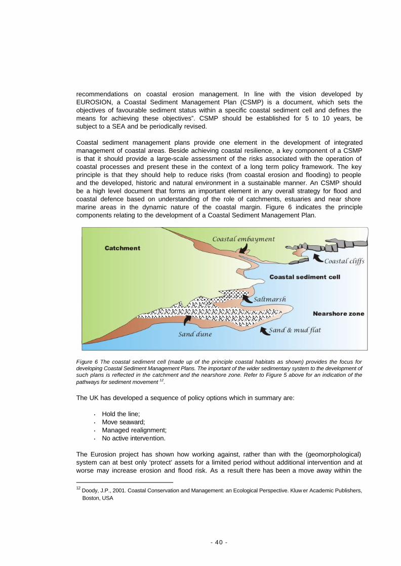
- 40 -
recommendations on coastal erosion management. In line with the vision developed by EUROSION, a Coastal Sediment Management Plan (CSMP) is a document, which sets the objectives of favourable sediment status within a specific coastal sediment cell and defines the means for achieving these objectives”. CSMP should be established for 5 to 10 years, be subject to a SEA and be periodically revised. Coastal sediment management plans provide one element in the development of integrated management of coastal areas. Beside achieving coastal resilience, a key component of a CSMP is that it should provide a large-scale assessment of the risks associated with the operation of coastal processes and present these in the context of a long term policy framework. The key principle is that they should help to reduce risks (from coastal erosion and flooding) to people and the developed, historic and natural environment in a sustainable manner. An CSMP should be a high level document that forms an important element in any overall strategy for flood and coastal defence based on understanding of the role of catchments, estuaries and near shore marine areas in the dynamic nature of the coastal margin. Figure 6 indicates the principle components relating to the development of a Coastal Sediment Management Plan.
Figure 6 The coastal sediment cell (made up of the principle coastal habitats as shown) provides the focus for developing Coastal Sediment Management Plans. The important of the wider sedimentary system to the development of such plans is reflected in the catchment and the nearshore zone. Refer to Figure 5 above for an indication of the pathways for sediment movement 12. The UK has developed a sequence of policy options which in summary are:
• Hold the line; • Move seaward; • Managed realignment; • No active intervention.
The Eurosion project has shown how working against, rather than with the (geomorphological) system can at best only ‘protect’ assets for a limited period without additional intervention and at worse may increase erosion and flood risk. As a result there has been a move away within the
12 Doody, J.P., 2001. Coastal Conservation and Management: an Ecological Perspective. Kluw er Academic Publishers,
Boston, USA
- 41 -
first two policy options, towards a more ‘limited intervention’ approach working with natural processes. Increasingly this has included active management to restore habitats through managed realignment, or allowing nature to take its course and taking no action at all. Assessing these options requires an understanding of the driving forces and their impact on the system as a whole. Climate change, urbanization and changes in agricultural practice are amongst a large number of these forces. Each can have both positive and negative effects. For example greater precipitation and more frequent and intensive storms could result an increase in the release of sediment, as erosion takes place in the hinterland or along a cliffed shoreline. On the other hand urbanization or a move away from more intensive forms of agriculture may reduce the rate at which soil erosion takes place and hence reduce the availability of sediment. It is essential that the balance of these and other forces is fully understood in relation to sediment availability and flood risk. A first stage in any CSMP must therefore include identification of all the principle forces influencing the rate at which sediment is removed from (or delivered to) the system and the way in which the dynamics operate. These will need to be assessed:
Ø on a timescale of at least 30 years, increasing to 50 or 100 years in some cases; Ø with an understanding of the whole sedimentary system from the catchment to the
coast and including the nearshore marine environment (see figure 6 above); Ø and takes account of economic, social and environmental effects.
Although the consequences of erosion may be loss of property and land the greater impact is caused when low-lying areas (particularly at the coastal margin) flood. It is therefore important to recognize the value of coastal sedimentary habitats (notably tidal flats, saltmashes and sand dunes) in providing natural defences. At the same time the opportunities for restoring nature conservation, recreational and landscape features in realignment or non intervention schemes should not be overlooked. Content of coastal sediment management plans The shore and sediment management planning process should:
Ø Determine the ‘undisturbed’ and ‘present’ sediment conditions within the coastal sediment
cell in terms of: • Natural and present sediment budget including quantification of sediments supplied by
sediment sources (e.g. rivers, cliffs, shoals), transported by currents and fixed by sediment sinks;
• Composition, size and distribution of sediment particles in the nearshore and foreshore (sedimentology);
• Composition and distribution of sediment-dwelling in fauna (benthic); • Geology and geomorphology of the coastline; • past and present coastline positions; • Coastal bathymetry and elevation; • Water levels including wave regime, astronomic tides, extreme water levels and
historical trends of sea level rise; • Past and present land cover; • Major infrastructure impeding sediment transport (e.g. dams, harbour, jetties, seawall).
- 42 -
Ø Review the effects of climate change on coast and fluvial flooding, urban drainage systems and sewer flooding and on coastal erosion. Consideration should be given to the effects if nothing is done to combat global warming;
Ø Map coastal erosion hazard and risk for different time horizons – e.g. 25, 50 and 100 years
– with and without coastal defence measures and for different scenarios of sea level rise. Wherever coastal erosion may result in coastal flooding, coastal erosion mapping shall be extended to coastal flooding mapping.
Ø Assess the assets located within areas prone to coastal erosion and erosion-induced
coastal flooding. This assessment shall be based upon data on: • Population; • Land market value; • Economic registered activities; • Areas of high ecological value; • Cultural heritage including for example archaeological sites, designated buildings,
historic battlefields and other remarkable sites. Ø Define the objectives of the CSMP in terms of target thresholds for meeting the conditions
of a ‘favourable sediment status’ within the coastal sediment cell. These objectives may be best described using a combination of 4 generic policy options:
• Hold the line , by maintaining or increasing the standard of protection leaving the location of the coastline unaltered. This may include supplementing the sediment budget to achieve a ‘dynamic equilibrium’ of coastal processes;
• Move seaward, by constructing new defences seaward the original defences. In the context of the sediment management this may include beach nourishment;
• Managed realignment by allowing a landward movement of the shoreline position with some form of management intervention, on both flood and erosion prone frontages. This may or may not include a identifying a pre-defined landward defence position. This approach may or may not require the use of additional sediment supplies to augment the sediment released during the realignment process;
• No active intervention, by making no investment in shoreline management i.e. allowing natural processes to ‘take their course’.
Note: These options are derived from the generic policy options identified in the UK. They have been amended to reflect the importance attached to sediments in the management of the coast. Ø Propose measures to meet the conditions of ‘favourable sediment status‘ as defined above.
These measures may combine a wide range of instrument including: • The designation of strategic sediment reservoirs as a key instrument to restore coastal
resilience by supplying sediments where needed and providing space for coastal processes. Note the reservoir may come from an adjacent cell, offshore or could be related to management in the catchment. (Overgrazing in upland areas followed by erosion could contribute additional material via river transport to the coast. Afforestation, reduction or cessation of grazing might have the opposite effect, though could also help reduce the incidence of flooding.);
• The modification of spatial planning documents to reflect the designation of strategic sediment reservoirs and the results of risk and hazard mapping.
• The designation of types of activities types which shall be subject to an Environmental Assessment procedure (EIA or SEA) focusing on coastal erosion processes within the coastal sediment cell

- 43 -
• The introduction of regional and local regulations to mitigation the potential impact of human activities on coastal erosion processes. This may include for example building regulations, but also restriction of dredging activities during certain periods and for certain areas (in particular sediment reservoirs of types 1 and 2), or specific requirements for designing, constructing or decommissioning dams. For more information, the reader may refer to the document titled Part V – Guidelines for incorporating coastal erosion issues into Environmental Assessment (EA) procedures.
• The planning of coastal defence actions combining hard and soft engineering works such as beach nourishment, dune rehabilitation, breakwaters, seawalls, etc.
Ø Assess the costs and benefits of implementing the measures proposed in the CSMP.
Particular attention should be paid to external costs (i.e. the costs of environmental damages) and environmental benefits, which shall be balanced with the “do nothing” scenario (i.e. the costs and benefits of not implementing the CSMP).
Ø Specify the financing plan. The CSMP should clarify the sources of funding for
implementing the CSMP. Particular attention should be paid to the funding mechanisms proposed to accommodate the policy option involving “managed realignment”
Ø Establish monitoring procedures to ensure that the implementation of proposed measures
meets the objectives assigned to the coastal sediment management plan and in particular contribute to meet the conditions of favourable sediment status within the coastal sediment cell. The monitoring procedures should also include mechanisms to detect discrepancies between realisations and objectives and to trigger corrective actions if needed.
Responsibilities for elaborating and implementing the coastal sediment management plans Responsibilities for elaborating and implementing Coastal Sediment Management Plans (CSMP) should be devolved to regional authorities whose coastline is entirely or partly included in a single coastal sediment cell. When more than one region is concerned by a specific sediment cell, interregional arrangements should be established to elaborate CSMP. Beside regional authorities sharing the same coastal sediment cell, the preparation of CSMP should involve the participation of a wide range of stakeholders including: (i) the national authority (authorities) in charge of coastal erosion and coastal flooding
related issues; (ii) the national authority in charge of the environment; (iii) representatives of coastal municipalities; (iv) river district authorities; (v) harbour authorities; (vi) representatives of tourism industry; (vii) representative of fisheries and aquaculture companies; (viii) representatives of environmental interest groups; (ix) representatives of academic and research institutions; (x) representatives of coastal engineering companies; (xi) the national authority in charge of public works; (xii) the national authority in charge of housing; (xiii) the national authority in charge of maritime transport; (xiv) the national authority in charge of tourism;

- 44 -
(xv) the national authority in charge of rural affairs and aquaculture; (xvi) the national insurance supervisory authority; (xvii) the national federation(s) of insurance companies;
3.1. Elaboration at EU-level
EU Recommendation on ICZM: the results of EUROSION including the Shoreline Management Guide (providing best practice information on coastal erosion management) should be widely disseminated, e.g. to Member States, coastal networks, and EU funded projects.
Financial instruments (esp. Cohesion policy funding ‘Environment and Risk’, Rural development funding, and European Investment Bank): As part of the existing conditionality assessments, coastal erosion management projects should not be supported if they could cause adverse impacts requiring subsequent mitigation measures. Funding incentives should be provided to programmes aimed at restoring the sediment balance and coastal resilience.
3.2. Elaboration at Member States level
Responsibilities for elaborating coastal sediment management plans should be devolved to regional authorities whose coastline is entirely or partly included within a coastal sediment cell. When more than one region is concerned interregional arrangements should be established to elaborate shoreline management plans. Member States should promote the dissemination of best practice information on coastal erosion management (incl. the EUROSION Shoreline Management Guide) in their own language.
3.3. Elaboration at the level of coastal regions:
Regional authorities should undertake responsibility for the development of CSMPs and ensure that shoreline management is made fully compliant with the above principles of accountability.
CSMPs should be established for 5 to 10 years, be subject to a SEA, and periodically evaluated and revised.

- 45 -
EUROSION Recommendation nr. 4
Strengthen the knowledge base of coastal erosion management and planning
The knowledge base of coastal erosion management and planning should be strengthened through the development of information management strategies. These should include as a starting point dissemination of ‘best practice (what works and what doesn’t), provide a proactive approach to data and information management and have institutional leadership at the regional level. The uncoordinated approach to information provision and as a consequence the often inadequate bases upon which decisions have been made in the past are highlighted in Finding 5. As a response to these major shortcomings strategic recommendation 4 proposes a proactive approach to coastal data and information management in Europe. This approach aims at promoting the institutional leadership of regional authorities to provide the impetus for facilitating accessibility to existing data sources, advising on future production of information and knowledge, and spreading best practice in the fields of shoreline management. Information lies at the heart of good decision making. The results of the Information Thematic review for the EU Demonstration Programme on ICZM suggest that in order to facilitate appropriate action information is needed at all levels of policy formulation and management action. A cascade of points for the exchange and dissemination of information and knowledge was proposed. At each level identifying the need and collecting and collating relevant information helps communication and the understanding of the issues and their possible solutions. In addition by feeding experience and information upwards lessons can be shared with others. At the same time wider contextual understanding (disseminated from above through national and/or European data sets or by aggregation of local information) helps ensure local action takes full account of legislative requirements, is appropriate to the situation and does not compromise adjacent areas or interests. Inadequate information will result in a continuation of the present unsatisfactory situation identified within EUROSION where inappropriate action is taken, which can be costly, unsustainable and detrimental to the environment. Below is a review of key information proposals that are expected to improve the way coastal erosion is addressed in Europe Exposure of European coastal regions to coastal erosion At the European level, EUROSION recommends a rating of European coastal regions according to their exposure to coastal erosion. In turn, this rating should serve as a basis for establishing priorities for implementing the EUROSION recommendations, and should be revised every 10 years. Methodology to establish the rating should build upon the approach developed during the EUROSION project and capitalize on the results of its Europe-wide database. This approach consists of quantifying the different factors impacting on coastal erosion processes (pressure factors) or affected by coastal erosion processes (impact factors), and combining these factors as described hereafter:
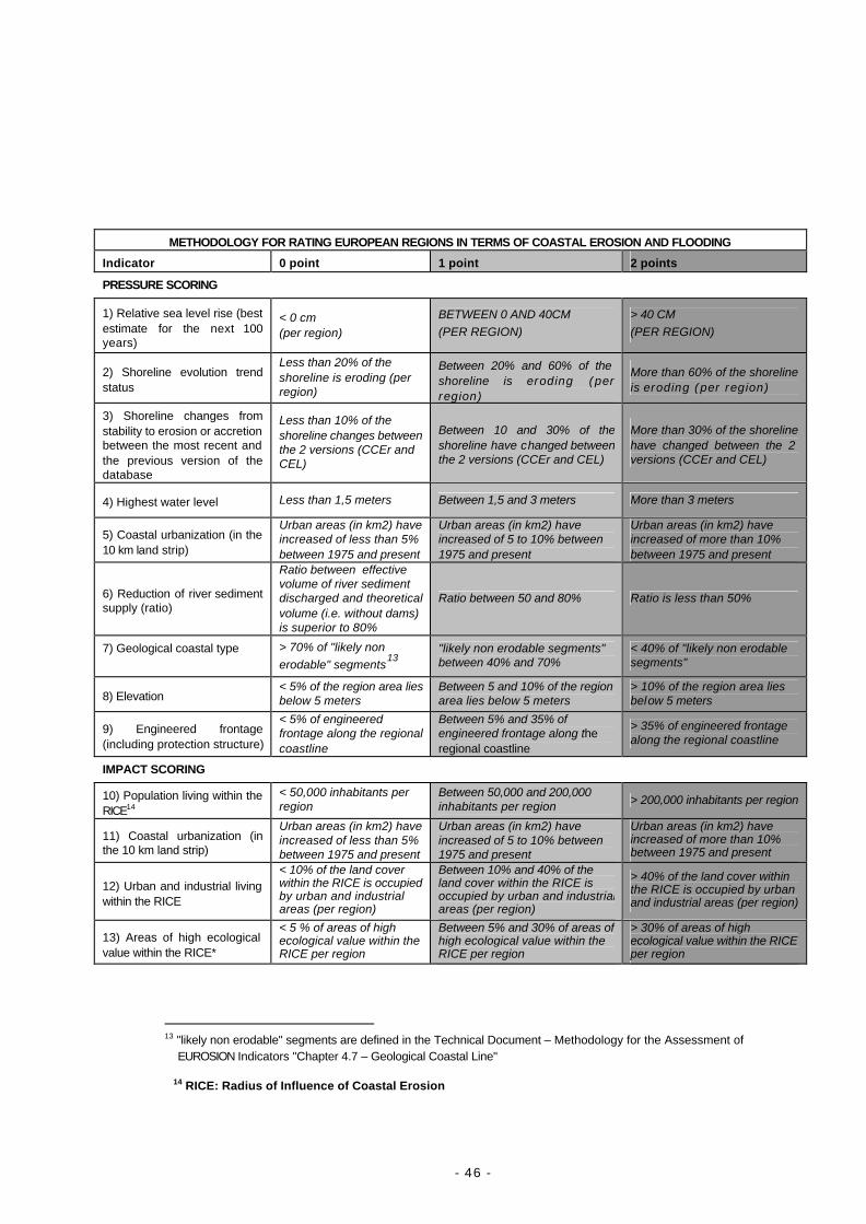
- 46 -
METHODOLOGY FOR RATING EUROPEAN REGIONS IN TERMS OF COASTAL EROSION AND FLOODING
Indicator 0 point 1 point 2 points
PRESSURE SCORING
1) Relative sea level rise (best estimate for the next 100 years)
< 0 cm (per region)
BETWEEN 0 AND 40CM (PER REGION)
> 40 CM (PER REGION)
2) Shoreline evolution trend status
Less than 20% of the shoreline is eroding (per region)
Between 20% and 60% of the shoreline is eroding (per region)
More than 60% of the shoreline is eroding (per region)
3) Shoreline changes from stability to erosion or accretion between the most recent and the previous version of the database
Less than 10% of the shoreline changes between the 2 versions (CCEr and CEL)
Between 10 and 30% of the shoreline have changed between the 2 versions (CCEr and CEL)
More than 30% of the shoreline have changed between the 2 versions (CCEr and CEL)
4) Highest water level Less than 1,5 meters Between 1,5 and 3 meters More than 3 meters
5) Coastal urbanization (in the 10 km land strip)
Urban areas (in km2) have increased of less than 5% between 1975 and present
Urban areas (in km2) have increased of 5 to 10% between 1975 and present
Urban areas (in km2) have increased of more than 10% between 1975 and present
6) Reduction of river sediment supply (ratio)
Ratio between effective volume of river sediment discharged and theoretical volume (i.e. without dams) is superior to 80%
Ratio between 50 and 80% Ratio is less than 50%
7) Geological coastal type
> 70% of "likely non erodable" segments
13
"likely non erodable segments" between 40% and 70%
< 40% of "likely non erodable segments"
8) Elevation < 5% of the region area lies below 5 meters
Between 5 and 10% of the region area lies below 5 meters
> 10% of the region area lies below 5 meters
9) Engineered frontage (including protection structure)
< 5% of engineered frontage along the regional coastline
Between 5% and 35% of engineered frontage along the regional coastline
> 35% of engineered frontage along the regional coastline
IMPACT SCORING
10) Population living within the RICE14
< 50,000 inhabitants per region
Between 50,000 and 200,000 inhabitants per region > 200,000 inhabitants per region
11) Coastal urbanization (in the 10 km land strip)
Urban areas (in km2) have increased of less than 5% between 1975 and present
Urban areas (in km2) have increased of 5 to 10% between 1975 and present
Urban areas (in km2) have increased of more than 10% between 1975 and present
12) Urban and industrial living within the RICE
< 10% of the land cover within the RICE is occupied by urban and industrial areas (per region)
Between 10% and 40% of the land cover within the RICE is occupied by urban and industrial areas (per region)
> 40% of the land cover within the RICE is occupied by urban and industrial areas (per region)
13) Areas of high ecological value within the RICE*
< 5 % of areas of high ecological value within the RICE per region
Between 5% and 30% of areas of high ecological value within the RICE per region
> 30% of areas of high ecological value within the RICE per region
13 "likely non erodable" segments are defined in the Technical Document – Methodology for the Assessment of
EUROSION Indicators "Chapter 4.7 – Geological Coastal Line"
14 RICE: Radius of Influence of Coastal Erosion
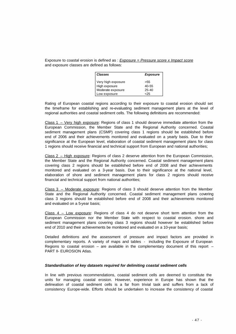
- 47 -
Exposure to coastal erosion is defined as : Exposure = Pressure score x Impact score and exposure classes are defined as follows:
Classes Exposure Very high exposure >55 High exposure 40-55 Moderate exposure 25-40 Low exposure <25
Rating of European coastal regions according to their exposure to coastal erosion should set the timeframe for establishing and re-evaluating sediment management plans at the level of regional authorities and coastal sediment cells. The following definitions are recommended: Class 1 – Very high exposure: Regions of class 1 should deserve immediate attention from the European Commission, the Member State and the Regional Authority concerned. Coastal sediment management plans (CSMP) covering class 1 regions should be established before end of 2006 and their achievements monitored and evaluated on a yearly basis. Due to their significance at the European level, elaboration of coastal sediment management plans for class 1 regions should receive financial and technical support from European and national authorities; Class 2 – High exposure: Regions of class 2 deserve attention from the European Commission, the Member State and the Regional Authority concerned. Coastal sediment management plans covering class 2 regions should be established before end of 2008 and their achievements monitored and evaluated on a 3-year basis. Due to their significance at the national level, elaboration of shore and sediment management plans for class 2 regions should receive financial and technical support from national authorities; Class 3 – Moderate exposure: Regions of class 3 should deserve attention from the Member State and the Regional Authority concerned. Coastal sediment management plans covering class 3 regions should be established before end of 2008 and their achievements monitored and evaluated on a 5-year basis; Class 4 – Low exposure: Regions of class 4 do not deserve short term attention from the European Commission nor the Member State with respect to coastal erosion. shore and sediment management plans covering class 3 regions should however be established before end of 2010 and their achievements be monitored and evaluated on a 10-year basis; Detailed definitions and the assessment of pressure and impact factors are provided in complementary reports. A variety of maps and tables - including the Exposure of European Regions to coastal erosion – are available in the complementary document of this report – PART II- EUROSION Atlas. Standardisation of key datasets required for delimiting coastal sediment cells In line with previous recommendations, coastal sediment cells are deemed to constitute the units for managing coastal erosion. However, experience in Europe has shown that the delineation of coastal sediment cells is a far from trivial task and suffers from a lack of consistency Europe-wide. Efforts should be undertaken to increase the consistency of coastal
- 48 -
sediment cell delineation throughout Europe notably by standardizing the production of key input datasets for such a delineation. These datasets are : Ø The coastline. Coastline can be defined as the interface between land, sea and air.
However, due to the dynamic forces operating at the coastal margin, its position cannot be precisely defined. The current and historical positions of the coastline are key information to understand coastal processes, anticipate future changes and prevent building in highly dynamic areas. It also plays an important role for delineating coastal sediment cells as it provides an overview of landforms. The EUROSION project has provided a representation of the European coastline at scale 1:100,000, based on which can be used as a starting point for the delineation of a more accurate coastline at scale 1:25,000 or higher which is necessary to delineate sediment cell boundaries with a sufficient level of accuracy. In turn, the coastline geometry acts a boundary condition for long-shore sediment transport. Accurate coastline shall be provided as a vector line with a horizontal positioning accuracy of 3 metres.
Ø Hydrography. Hydrography should include both a vector representation of rivers and their
catchment boundaries. A river catchment may be defined as the terrestrial area where the capture and transport rain and run-off waters move towards one particular outlet to the sea. Delineation of rivers and river catchments has been undertaken within the scope of the Water Framework Directive and should be made accessible at a scale ranging from 1:100,000 to 1:25,000 to coastal regions.
Ø Coastal elevation and bathymetry. Coastal elevation and bathymetry refer to the spatially
referenced vertical position of any given point of the surface above or below a datum surface usually taken as the sea level (“mean sea level” for terrestrial elevation, “lowest low water level” for bathymetry). Elevation and bathymetry provides a representation of the terrain, depicting contours or depth curves and providing a three-dimensional perspective. These are essential input data for the delineation of sediment cell boundaries since bathymetry interacts with nearshore wave propagation and cause approaching waves to divert their path (wave refraction). In turn wave refraction modifies the direction wave-induced currents, which is among the primary transport vectors of sediments. Bathymetry also contributes to identify underwater channels (or gullies) and offshore sand banks (or shoals) and hence the sediment transport paths and sinks. Finally coastal (terrestrial) elevation helps identify the landforms which play an active part into sediment transport processes such as headlands which disrupt long-shore sediment transport, or cliff and dune profiles which act as sediment sources. Coastal elevation and bathymetry may take the form of grid data or vector contour lines, but their accuracy should be better than 3 metre for horizontal positioning and better than 0.2 metre for vertical positioning. In the case of grid data, density of points should be at least 1 point per metre. In the case of vector contour lines, data should ideally range from –20 metres to + 20 metres with a spacing resolution of 1 metre.
Ø Nearshore wave regime. The wave regime defines the sea state in a specific area. It can be
defined as the physical and statistical characteristics of waves propagating over this specific area. Wave regime is characterized by a number of parameters which include wave heights, periods and direction and their remarkable value, such as their mean or their extreme values. More sophisticated parameters exist. Waves are generated by the action of winds over the sea surface. Wave regime is closely related to coastal processes in so far as energy liberated by breaking waves is directly responsible for sediment transport both cross-shore and alongshore. Key information on wave regime shall be provided as attributes of
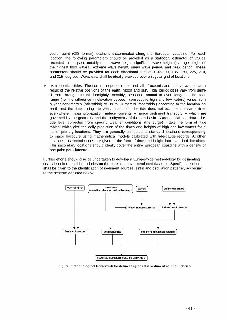
- 49 -
vector point (GIS format) locations disseminated along the European coastline. For each location, the following parameters should be provided as a statistical estimator of values recorded in the past, notably mean wave height, significant wave height (average height of the highest third waves), extreme wave height, mean wave period, and peak period. These parameters should be provided for each directional sector: 0, 45, 90, 135, 180, 225, 270, and 315 degrees. Wave data shall be ideally provided over a regular grid of locations.
Ø Astronomical tides: The tide is the periodic rise and fall of oceanic and coastal waters as a
result of the relative positions of the earth, moon and sun. Tidal periodicities vary from semi-diurnal, through diurnal, fortnightly, monthly, seasonal, annual to even longer. The tidal range (i.e. the difference in elevation between consecutive high and low waters) varies from a year centimetres (microtidal) to up to 10 meters (macrotidal) according to the location on earth and the time during the year. In addition, the tide does not occur at the same time everywhere: Tides propagation induce currents – hence sediment transport – which are governed by the geometry and the bathymetry of the sea basin. Astronomical tide data – i.e. tide level corrected from specific weather conditions (the surge) - take the form of “tide tables” which give the daily prediction of the times and heights of high and low waters for a list of primary locations. They are generally computed at standard locations corresponding to major harbours using mathematical models calibrated with tide-gauge records. At other locations, astronomic tides are given in the form of time and height from standard locations. This secondary locations should ideally cover the entire European coastline with a density of one point per kilometre.
Further efforts should also be undertaken to develop a Europe-wide methodology for delineating coastal sediment cell boundaries on the basis of above mentioned datasets. Specific attention shall be given to the identification of sediment sources, sinks and circulation patterns, according to the scheme depicted below:
Figure. methodological framework for delineating coastal sediment cell boundaries
- 50 -
Development of operational research on assessing the value attached to the coastline EUROSION findings have highlighted the operational gaps in assessing the social, ecological and economical value of the coastline. In the future, particular attention should be given to the development of techniques, which enable a cartographic representation of the cumulated social, ecological and economical values of the coastal zones. In turn, cartographic representation of values facilitating the transition from coastal erosion hazard maps to coastal erosion risk maps, and supporting the implementation of cost-benefit assessment studies should be made. Operational research on identifying and assessing values should build upon: Ø commonly-used data on population, land cover, land market values, infrastructure,
registered economic activities, areas of high ecological values and cultural heritage sites;
Ø GIS techniques, thus facilitating integration with other activities and in particular coastal
hazard mapping; Ø Existing research on coastal valuation techniques, in particular those techniques which
recognise the carrier, production, regulation and information functions of the coast. Development of academic research on climate changes effecting the shoreline Tremendous efforts have been undertaken on climate change so far, and especially on its impact on coastal ecosystems. These efforts should be continued and increased notably on the following particular aspects: Ø To assess quantitatively the impact of sea level rise on wetland evolution, especially
tidal sand and mud flats and salt-marshes, and the effects of associated mitigation and stabilization measures;
Ø To assess quantitatively the impact of climate change and sea level rise on return
periods of extreme wave heights along European coasts; Ø The assess quantitatively the extent of salt water intrusion induced by change of river
fluxes and sea level rise; Promotion of interregional cooperation focused on coastal sediment management planning EU Member States, European regions and the European Commission should broaden the scope of their respective instruments dedicated to interregional cooperation to support the joint elaboration of coastal sediment cell-based coastal sediment management plans (CSMP) by various regional authorities. Priorities shall be given to: Ø The development and dissemination of best practices dedicated to the integration of
coastal erosion concerns within Environmental Assessment (both EIA and SEA); Ø The development and dissemination of best practice dedicated to the elaboration of
coastal erosion hazard and risk mapping and their integration into spatial plans;

- 51 -
Ø The development and dissemination of best practice dedicated to coastal economics –
including proper methodologies to assess the economic value of beach use, coastal tourism, and coastal heritage – in order to better balance the costs and the benefits of Shoreline management measures;
Ø The development and dissemination of best practice dedicated public hearings and
sociologic studies to evaluate the social acceptability of coastline management scenarios;
Ø To design, experiment and disseminate results on innovative coastal engineering
techniques related to the creation of wetlands or artificial reefs, dune maintenance, beach drainage, cliff embayment or sand by-passing;
Ø The development and dissemination of best practice dedicated to shoreline monitoring
techniques, including ground-based, ship-borne, and air and space borne techniques, and modelling instruments to measure and anticipate coastline evolution at the local level, i.e. at scales 1:25,000 or better;
Ø The design and implementation of national and regional platforms for sharing data on
tidal and wave regimes, near-shore sedimentology, coastal infrastructure and bathymetry, to build better models of sediment transport and coastal erosion processes within the coastal sediment cell.
4.1. Elaboration at EU-level INSPIRE Directive. The future Directive meant to establish an Infrastructure for Spatial Data in Europe (INSPIRE) should support the standardized delineation of coastal sediment cells by incorporating key input datasets required for such a delineation into Spatial Data Infrastructure (SDI) standards being established under the terms of the Directive. GMES. Future community research activities of the Global Monitoring of Environment and Security (GMES) towards the establishment of Europe-wide standardized methodologies for delineating coastal sediment cells, including methodologies relating to the production or modelling of datasets required for delineating such sediment cells, and towards shoreline economics. As regards methodologies for delineating coastal sediment cells, a particular attention shall be paid to: Ø techniques combining very high resolution remote sensing products such as laser
altimetry or high frequency doppler sensors, and field surveying devices (e.g. GPS, WESP);
Ø improvement and integration of existing models used to simulate nearshore wave regime and nearshore currents. Major among these models in Europe are SWAN and UNIBEST (Delft Hydraulics), MIKE (Danish Hydraulics Institute), and TELEMAC (I).
As far as shoreline economics and in line with recommendation 4, priority should be given to the development of valuation techniques which enable a cartographic representation and GIS processing of social, ecological and economical values along the shoreline .

- 52 -
INTERREG. The European Commission should recognise the elaboration of coastal sediment cell-based Coastal Sediment Management Plans (CSMP) as a priority topic of regional development policies in coastal zones and support exchange of experience among regions and joint elaboration of CSMP accordingly via INTERREG funding.
European Environment Agency. The mandate of the European Environment Agency (EEA) and its Topic Centre on Terrestrial Environment (ETC/TE) should be extended to the periodical updating and assessment of the exposure of European coastal regions to coastal erosion and its reporting to the European Commission, Member States and coastal regions. It is however recommended that the update methodology is fine-tuned taking into account the following limitations and perspectives: Ø indicators no. 2 and 3 (shoreline evolution) suffer in some areas from a lack of
information of the CORINE Coastal erosion database (covering period 1985-1990). A significant part of the coastline (approximately 30%) does not include any validated information on erosion trends (mainly “presumed” information and to a lesser extent, missing information). In these conditions, it is difficult to discriminate between recently observed erosion trends (eroding sites which were not eroding in 1985-1990) from eroding sites already known in 1985-1990 as being eroding. In these cases, the project considered the presumed information featured in the database as being true (i.e. validated). For areas where such information was missing, the project gave the coastline section the highest score (2 points) by default;
Ø indicator no. 8 (elevation) can be improved through a better knowledge of coastal elevation – including a GIS representation of the 1-meter-contour line. This could help discriminate areas highly exposed to coastal flooding (below 1 meter) from areas moderately exposed to flooding (between 1 meter and 5 meters);
Ø Calculation of indicator no. 10 (population within the RICE) is based upon on the methodology developed by the Joint Research Centre of the European Commission (JRC)15. This methodology consists in reallocating demographic data – typically known at the level of European municipalities (NUTS5 level) – to land cover units, assuming that population are more likely to live in urban areas than in agricultural lands or forest areas. If the methodology is estimated by JRC to give good results for most European regions, less accurate data may be obtained in certain regions (errors may reach 5,000 persons). Development are still ongoing at JRC and EEA;
Ø Indicator 11 (coastal urbanization rate) is derived from the LACOAST data extended to accessing countries. However quality control procedures have revealed that LACOAST data for Greece suffer from a poor quality which tend to minimize the influence of demographic growth and urban sprawl in Greek coastal areas;
Ø Attempts have been made to cover the concept of “major” socio-economic assets with indicator no. 12, but it is realised that some important assets will be missed e.g the presence of a (nuclear) power station within the RICE; nor does it preclude that some assets of sub-national importance may require immediate erosion management measures;
Ø Indicator no. 13 can provide best results if Natura 2000 GIS files could be used. However, due to access restrictions to Natura 2000 data by the Commission and Member States, CORINE Biotopes database has been used as a proxy of areas of
15 Gallego J., Peedell S., Using CORINE Land Cover to map population density, JRC, 2000 (contribution to the
publication “Towards agri-environmental indicators”, EEA)
- 53 -
high ecological values. The assessment should be fine-tuned as soon as Natura 2000 GIS data become available;
Ø The rating of European coastal regions according to their exposure to erosion, and mapping them, can in no way be prescriptive in terms of shoreline management policy options. The level of details featured by the Europe-wide database, however, preclude any precise recommendations. They should be seen as instruments to set priorities in terms of setting a timeframe for establishing and re-evaluating shoreline management plans and investments. Further investigations will be needed to confirm and quantify the risks so that decision-makers are provided with the best available information for policy development;
Ø Finally, the calculation of exposure indicators at the level of European coastal sediment cells instead of coastal regions may be far more relevant. This depends however on the availability in the near future of coastal sediment cell boundaries.
4.2. Elaboration at Member States level
Member States should support the standardized delineation of coastal sediment cells at the level of their respective territory, via the production of key input datasets – namely accurate coastline position, coastal elevation and near-shore bathymetry, hydrography, near-shore wave regime, and tide prediction – and their integration into their national spatial data infrastructure (NSDI). Member States should also liase to the GMES initiative to jointly develop a standardized methodology for mapping the boundaries of European coastal sediment cells, with a particular emphasis on cross-border coastal sediment cells.
Finally, Member States should support interregional cooperation as well as research and development to support the joint elaboration of coastal sediment management plans (CSMP)
4.3. Elaboration at the level of coastal regions At regional to local scales, production, processing, storage, update, exchange and dissemination of relevant information on coastal erosion processes and coastline management should be considered as key prerequisites to ensure successful shoreline management operations. Regional authorities should play a lead role in creating the adequate institutional and technical conditions for such activities to take place, and their benefits maximised. This should be achieved through the elaboration and implementation by regional authorities of a strategy on “coastal information governance”. This strategy should not be restricted to coastline management, but extended to the broader context of integrated coastal zone management, wherever such approaches exist. These regional information strategies should build upon the following principles:
• Principle 1 - a lead authority working in partnership with a wide range of local to national stakeholders;
• Principle 2 – a commitment to share relevant information (or data); • Principle 3 - use a well-documented web-based information system using
internationally recognised standards; • Principle 4 - institutions retain responsibility for their own data including quality,
timeliness and for its dissemination;
- 54 -
• Principle 5 - the information system should be based on relevant and reliable data;
• Principle 6 - adequate training; • Principle 7 - cost sharing by all partners; • Principle 8 - the system is reviewed periodically; • Principle 9 – regular review of the strategy realisation and performance
Coastal information governance strategies shall be supported in particular by the implementation of local information systems the general function of which should be to support the elaboration of coastal sediment management plans, and more specifically the characterization of undisturbed and present sediment conditions, the elaboration of coastal erosion hazard and risk mapping, the implementation of cost-benefits analysis and the support to environmental impact studies (EIS) focusing on coastal erosion processes. Tentative specifications for such local information systems have been developed by EUROSION in a document called Guidelines for implementing local information system dedicated to coastal erosion management.