living with the river - taranaki · living with the river -te awa this unit of work focuses on...
TRANSCRIPT


September 2016
To the Teacher
Living with the river - Te Awa
This unit of work focuses on rivers, streams and other waterways in the Taranaki environment.
It aims to give children awareness, knowledge, skills, attitudes and values to take responsibility for this important part of their environment. The information within the unit can be adapted to suit all class levels. The activities covered offer some guidance for teachers planning within the science, social sciences and technology curricula.
The material within the unit is sourced from a number of places, with the majority coming from Taranaki Regional Council documents and the expertise of council staff associated with freshwater resources. The activities do not need to be completed in any particular order.
It is hoped that you find this unit of use and we welcome any feedback. Please feel free to photocopy the material within the unit at your discretion. If you would like more assistance or our Education Officer to help with a field trip or class visit, please don’t hesitate to contact the Taranaki Regional Council.
Yours faithfully
B G Chamberlain General Manager
per: R J Ritchie
Communications Manager
Doc #39615

Table of Contents
Cross-Curricula 2
Curriculum Links 3
Introduction 5
Activity 1: Class discussion 6
Activity 2: Mapping and diagram of river terms 7
Activity 3: Mapping 9
Activity 4: From mountains to the sea 10
Activity 5: Pollution 11
Activity 6: Water temperature 12
Activity 7: Chemistry – pH 14
Activity 8: Measuring river flow – maths-physics 15
Activity 9: Turbidity 16
Activity 10: Visual Art 17
Activity 11: Maori Tikanga and Reo 18
Activity 12: Written Language – Poetry 19
Activity 13: River life 20
Activity 14: Stormwater or sewage where does it all go? 24
Activity 15: River safety 25
2
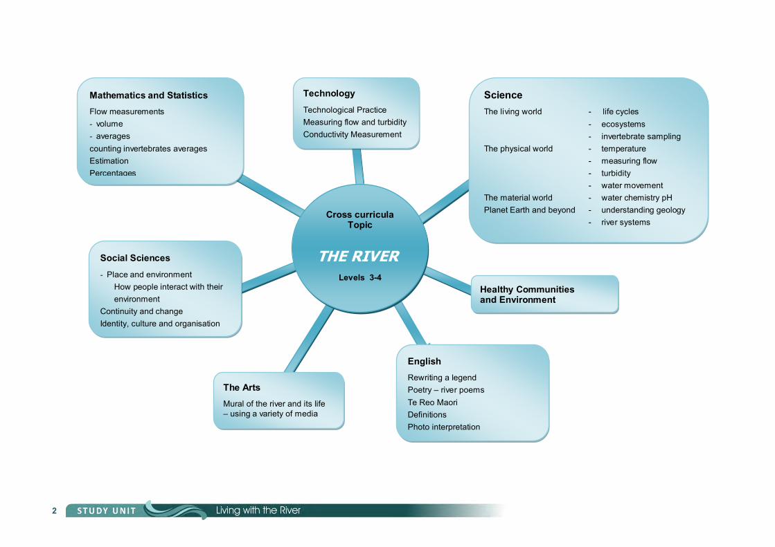
Mathematics and Statistics Flow measurements volume averages counting invertebrates averages Estimation Percentages
Technology Technological Practice Measuring flow and turbidity Conductivity Measurement
Science
The living world - life cycles - ecosystems - invertebrate sampling The physical world - temperature - measuring flow - turbidity - water movement The material world - water chemistry pH Planet Earth and beyond - understanding geology - river systems
Cross curricula Topic
THE RIVER
Levels 3-4
Social Sciences Place and environment How people interact with their environment Continuity and change Identity, culture and organisation
English Rewriting a legend Poetry – river poems Te Reo Maori Definitions Photo interpretation
The Arts Mural of the river and its life – using a variety of media
Healthy Communities and Environment

3
Curriculum Links
Mathematics and Statistics
Statistics Children will have opportunities to recognise appropriate statistical data for collection, and develop the skills of collecting, organising, and analysing data, and presenting reports and summaries.
Number Children will have opportunities to:
develop an understanding of numbers, the ways they are represented, and the quantities for which they stand develop accuracy, efficiency, and confidence in calculating – mentally, on paper, and with a calculator.
Measurement Children will have opportunities to:
develop knowledge and understanding of systems of measurement and their use and interpretation develop confidence and competence in using instruments and measuring devices.
Social Sciences
Place and Environment: Students will learn about how people perceive, represent, interpret and interact with places and environments.
Level 1 Using a range of skills, students will demonstrate their understandings of how a natural feature and a cultural feature in the local area affect people, and how people affect these features.
Level 2 Using a range of skills, students will demonstrate their understandings of how and why people perceive their local waterway differently.
Level 3 Using a range of skills, students will demonstrate their understandings of people’s perceptions of different environments and the reasons for these perceptions.
Level 4 Using a range of skills, students will demonstrate their understandings of how and why the interactions between people and the environment change over time.
Identity, Culture and Organisation: Students will learn about society and communities and how they function, about the diverse cultures and identities of people and about the impact of these on the participation of groups and individuals.
English
Speaking, writing and presenting students need to select ad use sources of information, processes and strategies to identify, form and express
ideas. students will be able to seek feedback and make changes to presentations to improve clarity, meaning and
accuracy.

4
Science
Living world Life Processes
In their study of the living world, students will use their developing scientific knowledge, skills, and attitudes to:
recognise that all living things have certain requirements so they can stay alive; recognise that living things are suited to their particular habitat
Planet Earth and beyond Earth cycles
Observe and describe local natural features and how they can change Interacting cycles. Investigate how natural events and human actions can affect conditions for living on Earth. Describe how natural events and human actions can affect the local environment
Physical world Physical enquiry
Seek and represent patterns in physical phenomena
Material world Chemical reactions
Observe and describe temporary and permanent change to familiar materials.
Technology
Technological practice students investigate an environment, eg, a stream bed; teacher arranges for an expert to talk about the stream bed ecological community; students visit the stream community to view the environment and interaction that takes place.
Technological knowledge students consider the needs of specific animals in terms of water quality, temperature, protection from predators,
access to food; students in groups devise and apply methods for capturing, identifying and releasing animals for study purposes; students compare findings from one site to another.
Nature of Technology students investigate how rivers have been used by society for water uptake, waste disposal, electricity
generation, recreation etc; students survey people to see how they feel about water pollution, the need for clean water, etc.
Assessment students write a report on their findings.
Arts
Visual Arts students may share ideas about how and why their own and others’ works are made and their purpose,
value and context.

5
Introduction
Wonderful water The water on the earth is constantly being recycled. It has been used over and over again by people, animals and plants throughout history.
Water is in the food we eat, the liquids we drink and the wastes we produce.
Our life is sustained by it. We use it to swim in, fish in and travel on. Our animals use it. We clean in it. Millions of products are made from it.
About 70% of our bodies are water and fruit and vegetables may consist of 90% water.
Water is used to generate electricity, irrigate our plants, put out fires and water our animals.
As well as this, over 50% of the world’s species are supported by flowing fresh water.
In New Zealand, 27 species of native fish live in fresh water, as well as hundreds of species of invertebrates.
Taranaki River facts Taranaki has over 540 named rivers and streams including 148 significant waterways. The largest in terms of water flow is the Waitara followed by the Patea. These rivers contain many fish and invertebrate species.
In Taranaki we use over 474,371m3 per day, this is the equivalent of 194 Olympic-sized swimming pools. Thirty two percent of that is for municipal and rural water supply.
Did you ever wonder why many rivers have water in them when it hasn’t rained for days or weeks, there’s no snow melting, and the ground is dry? The rivers are being filled up by water coming from out of the ground in the form of springs and seepages which brings us on to the topic of groundwater.
Groundwater facts Groundwater is water which occurs in formations below the earth’s surface. In Taranaki we use 44,022m3 per day but recharge approximately 4,600,000m3 per day.
The purpose of this study is to focus on the importance of the river as a source of fresh water and the need to keep it unpolluted and conserved for ourselves and future generations.
We will examine some effects of human impact on water and how we can look after our precious fresh water resource.

6
Activity 1: Class discussion
On a whiteboard or large piece of paper discuss:
Possible Answers
What is a river? (a flow of water over land)
Where does a river begin? (a lake, mountain headwater, wetland)
What is the start of a river called? (it’s source)
Where does a river end? (at the sea or lake)
What is the end of a river called? (it’s mouth)
Where does the water come from to fill a river? (rainwater, groundwater, melting snow or ice)
What is taken out of a river? (water, fish, rocks, sand)
Why are most towns by a river? (water supply, treated waste discharge, transport)
What is special about Taranaki rivers? (most radiate from the mountain )
What lives in rivers? (fish, invertebrates)
How many of us have used a river recently?
Have you - :
had a swim gone fishing been canoeing gone for a walk by the river
If you haven’t done any of these things, you have probably used water that came from a river by drinking water or having a wash.
KEY COMPETENCIES: Managing self Participating and contributing
Thinking

7
Activity 2: Mapping and diagram of river terms
Cross section of a river Below is a diagram of a river with the appropriate terms included.
This diagram shows the river and how water flows into it.
From the definitions below draw and label a diagram to show the following:
confluence where rivers flow into one another
estuary widening channel of a river where it meets the sea
meander curve or bend in a river
tributary stream or river that flows into a larger one
wetland an area of marshy land
mouth where the river meets the sea
source/headwaters the beginning of a river
catchment area area of land draining into a river
watershed the dividing line on a ridge between two river systems
weir low dam built across a river to control its flow.
KEY COMPETENCIES: Managing self
Using language, symbols and text Thinking

8
Activity 3: Mapping
Activity On the map provided in the appendix, highlight the course of the rivers listed below following them from headwaters to sea.
1. Tongaporutu 2. Waitara 3. Waitotara
4. Waingongoro 5. Te Henui 6. Stony
7. Waiaua 8. Kaupokonui 9. Patea
10. Waiwhakaiho 11. Urenui 12. Tangahoe
Catchment
A river’s catchment area is the total land area that drains into the river.
Activity 1. Trace the Patea and Waitara rivers’ courses and include the main tributaries that lead into them.
2. Contact the TRC Education Officer for maps showing the Waitara and Patea rivers’ catchment areas.
Note: some of the catchment is from the mountain, some is from the eastern hill country.
KEY COMPETENCIES: Participating Using language, symbols and text

9
Activity 4: From mountains to the sea
Water flows from high ground (hills, mountains, etc) to low areas, valleys, flats and eventually to the sea.
All land that brings water into a particular river is said to be part of that river’s catchment. Some rivers have smaller tributaries as part of their catchment.
For example the Waitara and Patea Rivers have many other streams and rivers (tributaries) which bring water into them.
Experiment 1 Using a sheet of polythene and props such as boxes, bricks and blocks, screwed up paper etc,
create an artificial landscape. Sprinkle water over the landscape to simulate rain falling. Observe how the water behaves on different terrain.
KEY COMPETENCIES: Managing self
Participating and contributing
Relating to others

10
Activity 5: Pollution
Because rivers drain the land they can also carry in them contaminants that are washed from the land, such as fertilisers, weed killers, other chemicals and bacteria.
Experiment 2 Create an artificial landscape similar to Experiment 1. Put some material such as an old towel or foam sponge
with some detergent or food colouring in it. Sprinkle water over the landscape as before. Observe how the chemicals wash through and drain into the rivers. This shows how the rain on land carries chemicals in the rivers polluting them and thereby eventually the sea.
Question – what are some of the ways we can avoid pollution of our waterways?
Note: You can also apply wet sand and dirt to the polythene to show how this gets washed into the river and carried along.
KEY COMPETENCIES: Managing self Participating and contributing
Thinking

11
Activity 6: Water temperature
The temperature of water is of great importance when it comes to monitoring waterways.
Scientists monitor water temperatures closely as they can have quite an effect on stream life, especially in summer when air temperature is higher and waterways are shallower and lower in flow.
The sun will heat rocks and boulders, especially in summer when flows are low.
Rivers that have little shade are particularly vulnerable to increased water temperature.
The water temperature problem can be made worse if heated water is discharged into a river.
Warm water temperature can affect streams in the following ways:
Less dissolved oxygen in water Warmer water holds less dissolved oxygen than cooler water. Organisms in the water such as fish and invertebrates also use more oxygen in warmer conditions as their metabolism increases.
More plant and algae growth Warmer temperatures enable plants to grow more vigorously and can lead to more algae and plants clogging waterways. This plant life uses oxygen from the water during the night.
Greater sensitivity to toxic waste, parasites and diseases Warmer water temperatures stress most aquatic organisms and can make them more prone to other issues. The larvae of some fish are even less tolerant of extreme temperatures.
Decreased invertebrate communities Stonefly numbers decrease with water temperatures over 19 °C.
Water temperatures between 21 and 24 °C may be lethal to many invertebrates.
Certain undesirable life may flourish in high temperatures (eg, sewage fungus’).
Most native freshwater fish prefer temperatures from 10 to 15 °C.
What causes increased water temperature? Warm water being put into the waterway. This may come from surface run-off or from an industrial discharge. Low flow conditions allowing shallow waterways to heat up more easily due to increased surface area and
heating from boulders etc in the stream. Sediments which absorb more heat and sometimes decrease the depth of waterways increasing surface area. Removal of vegetation around waterways allowing the sun to shine directly onto the water.
KEY COMPETENCIES: Managing self Participating and contributing
Using language, symbols and text

12
Activity 6: Water temperature (cont’d)
Riparian planting (Riparian means alongside a waterway)
One of the best ways to reduce water temperatures is to plant trees and other vegetation along the sides of waterways.
As well as keeping the water cooler, riparian planting also has the benefits of:
reducing run-off of pollutants into waterways
reducing the impact of flooding
providing habitat for wild life – bird, fish, insects
providing shelter reducing riverbank
erosion reducing algal growth
on the stream bed
Activity Practise using a thermometer correctly.
Using the same thermometer, ask several children to read it and record as accurately as possible their readings.
Compare the differences in different children’s readings. This emphasises the need to be accurate and provides a more realistic measurement.
Ensure children are aware of the scale of the thermometer and what each incremental line means.
Practise taking the temperatures in different water bodies in the environment (it is important to keep the thermometer in the water body when reading the thermometer).
For example:
a puddle the school pool the goldfish bowl the local river
Also measure air temperature comparing full sun with shade.
talk about the differences and try to explain them.
Experiment Measure the water temperature in the tray of water that has been in the direct sun all day
and compare the measurement with a tray of water that has had shade over it. For more information on riparian management contact the Taranaki Regional Council.

13
Streambank (Riparian) planting
Above: Landowners collecting their riparian plant orders
Below: Established riparian planting following the contours of a stream

14
Activity 7: Chemistry – pH
Rivers have all sorts of pollutants in them, some of them naturally occurring, many of them caused by humans.
One of the tests that scientists do to see if there is pollution in water is a pH test.
A pH test tells us if the water is acidic or alkaline. The scale goes from 0 (very acidic) to 14 (very alkaline).
Each pH step away from neutral (pH7), is a ten-fold increase in acidity or alkalinity, eg pH3 is 10 times more acidic than pH 4.
Most river and stream waters in Taranaki are slightly alkaline, eg pH from 7 to 8.
Sometimes scientists find that water is acidic. This can be caused by some acid spilling into the water such as an accidental spill of trade waste. Acidic water can kill fish living in a waterway and make the water very toxic. Sometimes scientists find the water is very alkaline. This can be caused by excessive lime fertiliser or detergents in the water. This can cause too much plant growth in the waterway and block it or use up valuable oxygen in the water.
Experiment You will need 3 beakers or jars, pH indicators and colour match sheets (provided), an acid solution such as
vinegar dissolved in water 50/50, an alkaline solution such as baking soda or bleach mixed with water (10 ml of bleach in 50 ml of water makes a good alkaline solution) and a sample of river water.
Mix each solution and place the indicator sticks in each one, match the stick against the colour chart to determine the pH level of your samples.
If you require more pH indicator sticks please contact the Taranaki Regional Council Education Officer.
KEY COMPETENCIES: Managing self
Participating and contributing
Thinking

15
Activity 8: Measuring river flow
River flow measurements provide us with a lot of valuable information such as:
what the normal flow of the river is, so it can be compared from year-to-year
how much water can be safely allocated to a resource user such as a factory, while there is still
enough water left for other users when the river is approaching a flood level where people need to be warned. how the river flow is measured in cubic metres per second (cumecs), one cumec equals
1000 litres per second.
NB: Safety It is never safe for students to take measurements in a deep part of a river so you should choose to measure a safe small section of the river.
For practice, take the following data and apply them to the formula. Depth measurements
0.5, 0.7, 0.9, 1.0, 1.1, 1.5, 1.2, 1.0, 0.9, 0.2.
River width 12 m
Time to flow 10 m = 16 secs
What is the flow? Answer 3.375 cumecs or 3375 litres per second.
KEY COMPETENCIES: Managing self
Participating and contributing Thinking

16
Activity 9: Turbidity
Turbidity is a measure of water clarity. Lack of clarity is usually caused by sediments being mixed up in the water.
Very turbid water looks dirty and can affect the quality of the water for the life within a river.
Turbid water cuts down light and affects plant growth and high turbidity can make it difficult for fish to feed as they can’t easily see their prey.
Turbidity can also make water less visually attractive. People usually prefer to play, swim and fish in crystal clear water rather than murky, turbid water.
Scientists measure turbidity in a number of ways – from using a periscope type apparatus to view an underwater disc; to using a tube filled with river water and a stick with a disc on the end to see at what distance you can see through the water.
Activity Think about the things that could make water more turbid, eg, rain washing over muddy ground with no
plants. Design and build your own turbidity measuring device. Fill a glass jar with river water and see if you can easily see through it.
Try this again after disturbing the substrate (sand, stones) on the riverbed.
Students participating in river studies, measure water clarity by using a turbidity tube.
KEY COMPETENCIES: Managing self Participating and contributing
Using language, symbols and text
Thinking

17
Activity 10: Visual Arts
As a method of evaluation and to help children express some of what they have learned about river life and issues.
This art activity could be done across two pages of an exercise book or on a piece of paper horizontally.
Ideally it could be done across a long classroom wall.
The first task is to put on the river itself with a section the entire length of the wall coloured blue to represent the water. This can be done with paint or crayon or something which doesn’t take too much time. This could be done on the floor then transferred to the wall.
The next step is to add to the wall illustrations of rocks, animals, plants, riffle sections, invertebrates. Above the water children can place trees and other plants, people fishing, houses, factories, discharges,
intakes etc. It would be easier if the children choose to do their pictures separately and then add them on as they finish
them. The pictures can also have captions
or speech bubbles with them to show some knowledge they have gained. For example, a detailed illustration of a trout with a speech bubble saying:
Children can also use collage or prints on the mural. See the appendix for information on what to write
I am a brown trout, I am an aggressive introduced fish and I enjoy feeding on invertebrates. I have few enemies and am popular with fishers.
KEY COMPETENCIES: Managing self Participating and contributing
Using language, symbols and text
18
Activity 11: Maori Tikanga and Reo
Maori legend of Mount Taranaki Legend has it that Mt Taranaki was once part of the central North Island mountains.
Mt Taranaki was said to have had a fight with Tongariro over Pihanga (a female mountain). Mt Taranaki was banished and fled. Its path being the Whanganui River.
Mt Taranaki then headed north and rested for a while on the way and this place of rest is said to be the Ngaere swamp. Mt Taranaki then moved to its present location.
It still cries for Pihanga and some people say that the tears from Mt Taranaki form the Patea River.
Some people also think that one day Mt Taranaki will return to the central North Island again. Watch out if it does!
Language The children can take the above story and write it in their own words, perhaps embellishing it with some of their own descriptive language.
Maori Reo au – force of water ehu – muddy wai – water
tuna – eel inu – drink tōtara – a native tree
papa – over the ground puna – spring awa – river
waipuke – a flood waka – canoe rua - two
iti – small nui – large rangi – sky
tāheke – cascade kiri kiri – stony tokanui – boulder
one - sandy whenua – land puke – hill
kura – reddish colour manga – a small river or stream awa awa – a valley formed by river
ko Pātea te awa o tōku iwi – Patea is the river of my tribe
See if you can match some words to find out the meanings of some of these river names.
Whenuakura Mangaone
Waitotara Pukerua
Manganui Waiau
Mangarangi Pukepapa
Waiiti Waipuna
Mangapapa Mangatuna
Mangawhero Waiinu
Mangaehu Wainui
KEY COMPETENCIES: Thinking
Using language, symbols and text

19
Activity 12: Written language – Poetry
Below is a poem taken from School Journal, Part 4, Number 1, 1991.
As you tickle and play around boulders and over stones like a fisherman casting for trout, the spring sunshine turns you into a ribbon of irridescence. Leaving behind shingle flats, covered with yellow broom, you flow through grasslands rolling down below black birch and rimu-covered hills. When ten-tiered West Coast torrents fall on endless days, swollen from vassal tributaries’ ceaseless spews, you tumble and plummet, cutting away banks carrying debris swaying high in perpetual dance on muddy waters. In control you wind in and out, plunging through gorges, booming fortissimo: “out of my way!” Reaching a town with buildings stretched unfenced along your banks, you strain to meet them, but you never will, for beyond, welcoming you … calls, pre-eminent, the irresistible sea.
MARLENE BENNETTS
This poem uses personification (giving an inanimate object a human quality) to describe the river. Simile is also used in ‘like a fisherman casting for trout’. Alliteration is used ‘spring sunshine’ and ‘below black birch’. It also uses a number of words to describe its movement, for example, tumble, plummet, plunging, reaches,
wind. A number of quality describing words are also used, such as vassal, ceaseless, pre-eminent, irresistible. This poem provides an excellent model for children to use descriptive writing.
Activity Give the children an opportunity to observe the river either at normal flow or in flood and write a poem of their
own, other words they may wish to use are meander, cascade, swift, eddying, swirl. This poem can also be used for an illustrated poem exercise and may make a good blackboard poem for a
handwriting exercise.
KEY COMPETENCIES: Thinking Using language, symbols and text

20
Activity 13: River life
Food chain/life cycles/water quality indicators: Invertebrates (animals without backbones) live in our rivers. There are many varieties and they are an important part of the food chain. The most common stream invertebrates are insects in their larval stage including mayflies, caddisflies and midges. These larva feed on plant debris and algae in the river; some also feed on other insect larvae. Fish feed on these invertebrates. These fish may include cockabully, whitebait species and trout. Bigger fish such as eels and trout feed on smaller fish and river birds may feed on them also. Humans sometimes eat eels and large fish like trout and this ends the food chain.
Life cycles Insects are probably the most successful creatures living in the rivers.
These river living insects have adapted from living on land and spend much of their life in the water. They have modified their breathing systems by having gills which take in the oxygen from the water.
These insects also have an abundant supply of food in the river, living off tiny plant and animal matter in the river.
Most of the adults then leave the water and return to the air. Why you ask!
Moving to outside the river enables the adults to lay their eggs upstream, or in other rivers or areas with better conditions. It would be very difficult for this to happen if the insect stayed in the river.
The larvae spend their time feeding and growing, while the adults purpose is to breed and ensure their eggs are dispersed.
Many adults have a very short life.
KEY COMPETENCIES: Managing self
Participating and contributing
Using language, symbols and text
Relating to others
Thinking

21
The life of some common river insects
Mayfly (Ephemeroptera)
The mayfly gives us an example of incomplete metamorphosis, ie, it changes from egg to larvae (nymph) to adult.
The mayfly nymph can be found on rocks on the river bottom in swifter flows and cleaner water.
It has three tail filaments which help to keep it facing the current. Its paddle-shaped gills on the side of its body help it extract oxygen from the water.
When the mayfly emerges it has two adult stages. First it has opaque wings and then it moults and
emerges as a winged adult.
The adult has mouth parts but does not feed. Its sole purpose is to mate and after spending a year in the water as larva, it may live for just a day or two or perhaps only hours.
Caddisfly (Trichoptera)
The caddisfly gives us an example of complete metamorphosis, ie, it changes from egg-to-larvae-to-pupae-to-adult.
The larvae live on the river bed usually building a portable case to live in or nets to catch food.
This case gives it physical protection and camouflage as it builds its case from sand grains, leaf or bark or other convenient local materials.
The materials are held together with silk from the insect’s body. Some species make their case from this silk alone.
Some caddisfly build silken nets between rocks on the riverbed and feed on the algae and bits of vegetation that are swept into it.
They then pupate in these cases.
When they emerge from the water the adult looks similar to a moth except with hairy wings and curved whip-like antennae.
The adults lay their eggs from dusk onward during the summer, crawling under the water surface to lay eggs on rocks and vegetation.

22
Activity 13: River life (cont’d)
Activity Draw the life-cycles of the two invertebrates described above showing the difference between complete and incomplete metamorphosis.
Research the life-cycle of other insects to compare with the caddis and mayfly.
Water quality indicators As well as being part of the food chain and having interesting life cycles these invertebrates tell us how healthy a waterway is. Some can only live in the cleanest water and some can live in water that is of poorer quality.
Scientists choose a river site and collect the invertebrate species in a net and then identify the creatures.
Each creature is given a grade from 1 to 10. 1 being very tolerant to polluted water, 10 being very sensitive to polluted water.
For example most mayflies have a score of between 7 and 10, this means they usually live in high quality water.
Refer to ‘A Photographic Guide to Freshwater Invertebrates of Taranaki’ for sensitivity scores.This book is available from the Taranaki Regional Council.
Caddisfly species scores generally average around 5-8 but some are as low as 2 and as high as 10.
Worm-like creatures range from 1 to 3 on the sensitivity scale, suggesting they can live in polluted water as well as clean waterways.
Scientists then count up the number of different creatures they find and average the scores of all the creatures they find and multiply by a scaling factor of 20 to give the river site a score.
For example if 30 different species were found and their combined score was 195 this would be divided by 30 to find the average which would be 6.5
This would then be multiplied by 20 to give a score of 130 for this river site.
Typically as we progress down the mountain the site scores decrease as more pollution impacts on the river and the water quality is lowered.

23
Activity 13: River life (cont’d)
Activity Invertebrate sampling Equipment - sieve or net, brush, white sorting tray, magnifying glass, identification sheet, bugbox
Method Find a safe river
site where water is running gently over the rocks (a riffle)
Holding the net or sieve downstream brush the under surface of the rocks so the invertebrates float into the net or sieve
Empty the sieve or net into the sorting tray and identify them using the bugbox guide
Average the sample and multiply by 20 to give your site a score Try the procedure at several sites for comparison.
Level 1 – River Study For primary school studies it is suggested that students use invertebrates, plus water temperature and water clarity activities only.
Level 2 – River Study For extension groups at primary school and Years 7-10, students should use invertebrates plus water temperature, water clarity, pH, water flow and conductivity activities.
Level 3 – SHMAK (Stream Health Measure and Assessment Kit)
This programme is designed for Y12-13 science classes and teachers are welcome to borrow our SHMAK, providing they have previously attended a SHMAK professional development session.

24
Activity 14: Stormwater or sewage
where does it all go?
What is stormwater? Stormwater pipes collect the rainwater that comes off our properties and paved areas such as paths and
roads at all times not just during storms. This water drains into grates and underground pipes and eventually finds its way to a stream or river and
then to the sea. If pollutants get into this water, they will go into a waterway and perhaps kill some fish or make the water
unhealthy to swim in. Stormwater should always be clean water. The stormwater pipes drain water from our streets to stop flooding.
What is sewage? Our sewerage system collects and disposes waste water. This wastewater includes water from our toilet and
sinks. This water contains liquids that need to be especially dealt with at a sewage treatment plant.
What shouldn’t go into a sewerage system? Solvents, oil based paints, thinners, herbicides and insecticides and other toxic chemicals should not go into
the sewer, as they can kill environmentally friendly bacteria and other organisms required by sewage treatment plants.
Stormwater shouldn’t go into the sewerage system. If it does it can overload the system, especially in heavy rainfall, causing sewage to overflow into other properties and streams.
Some hints Wash your car on the grass rather than on the street but not somewhere that goes into stormwater. Waste oil from your car should go to your service station for recycling.

25
Activity 15: River safety
Every year many New Zealanders lose their lives in or near rivers.
Rivers often have a fast continuous flow and contain dangerous objects in and around them.
Below are some things to watch out for when dealing with rivers and some do’s and don’ts.
The information is provided by the ‘Water Safety Council”:
River swimming Check for downstream hazards
(these may include boulders, or other material in the river which could snag you or hold you under) Avoid swimming under a bridge Ensure the water isn’t too fast or too deep If you get caught in the current, do not fight it but head downstream to a suitable landing beach. Never attempt to come ashore amongst trees or river debris.
Falls Be careful when walking near a river Avoid unstable river banks and grassy slopes
Fishing Fish in the company of others Avoid fishing during periods of high flow Watch your step and observe river characteristics If you fall in, keep calm and float downstream to a suitable landing beach.
Crossing a river Never attempt to cross a river if the water is discoloured, there is the sound of rolling boulders,
or the sign of debris and trees being carried along in the water Do not cross if the water is over your thigh and moving Do not cross if the water is moving faster than your walking pace Look for a crossing place that has an even river bed Look for a crossing place where there are easy entry and exit points.
Diving Never dive into a river unless you are sure of its depth Don’t jump off waterfalls.
Activity Discuss river safety in the class, perhaps relate stories when somebody got into trouble around a river.
Visit the river looking for possible river hazards.
For assistance at any level, please contact the Education Officer at the Taranaki Regional Council.
KEY COMPETENCIES: Managing self
Participating and contributing Relating to others
Thinking