living with volcanoes and earthquakes in indonesia mount sindoro, central java, indonesia
TRANSCRIPT

LIVING WITH VOLCANOES AND EARTHQUAKES IN INDONESIA
Mount Sindoro, Central Java, Indonesiahttp://en.wikipedia.org/wiki/Mount_Sundoro

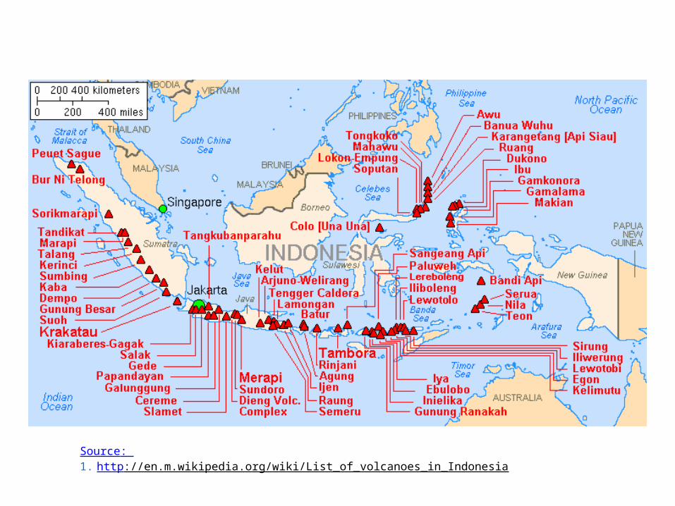
Source: http://en.m.wikipedia.org/wiki/List_of_volcanoes_in_Indonesia

INDONESIA
The geography of Indonesia is dominated by volcanoes that are formed due to subduction zones between the EURASIAN plate and the INDO-AUSTRALIAN plate.
Source: http://en.m.wikipedia.org/wiki/List_of_volcanoes_in_Indonesia


INDONESIA
Indonesia is the land of volcanoes located at the Pacific Ring of Fire.
In 2012, Indonesia had 127 active volcanoes.
The devastating earthquake and tsunami event of December 26, 2004 is thought to bring disruption to the volcanoes' eruption pattern.
Source: http://en.m.wikipedia.org/wiki/List_of_volcanoes_in_Indonesia

PACIFIC RIM MAP
http://www.worldatlas.com/aatlas/infopage/ringfire.htm
Source: 1. http://en.m.wikipedia.org/wiki/List_of_volcanoes_in_Indonesia

Java Island

JAVA ISLANDJava is almost entirely of volcanic origin, and there are numerous volcanoes (45 of which are considered active volcanoes).
Volcanoes have played a vital role in the geological and human history of Java. Land is created on Java as a result of lava flows, ash deposits, and mud flows (lahars).
Volcanoes are a major contributor to the immense fertility of Java, as natural erosion transports volcanic material as to the island's plains, forming thick layers of fertile sediment.
Source: http://en.m.wikipedia.org/wiki/List_of_volcanoes_in_Indonesia

JAVA ISLANDIn 2014, the Indonesian population reached 253 million people.
Java island is the most populated island in the world, and there are more 143 million people living in this island.
Languages use in Java island are Javanese, Sundanese, Madurese, and the national language of Indonesian.
Sourcehttp://en.m.wikipedia.org/wiki/List_of_volcanoes_in_Indonesia

The three major languages spoken on Java are Javanese, Sundanese and Madurese.


WELCOME TO CENTRAL JAVA(THE LAND WITH A VERY RICH CULTURE)
In this part of the island, the population consists of Javanese and Chinese. Most Javanese people are farmers, and the Chinese people are
doing business/trade.
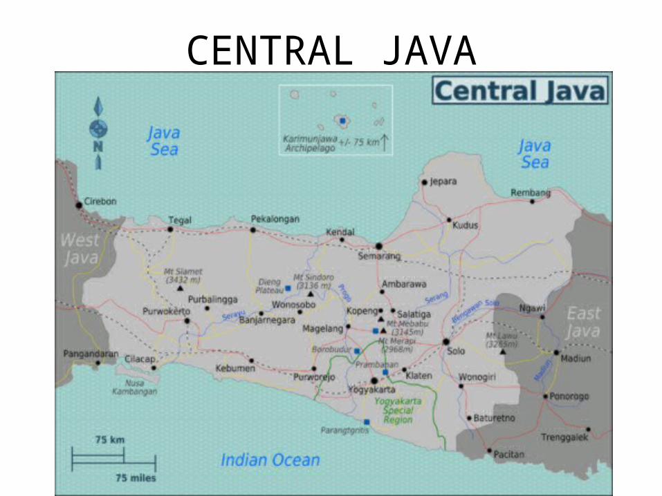
CENTRAL JAVA

CITY OF TEMANGGUNG

CITY OF PARAKAN

MT. SINDORO ON JULY, 2014(Taken by Daniel Enberg)

Sun rise at Mt. Sindoro
http://theriwans.blogspot.com/2015/01/gunung-sindoro.html

MT. SINDOROCRATER:KembangCrater
Source: http://theriwans.blogspot.com/2015/01/gunung-sindoro.html
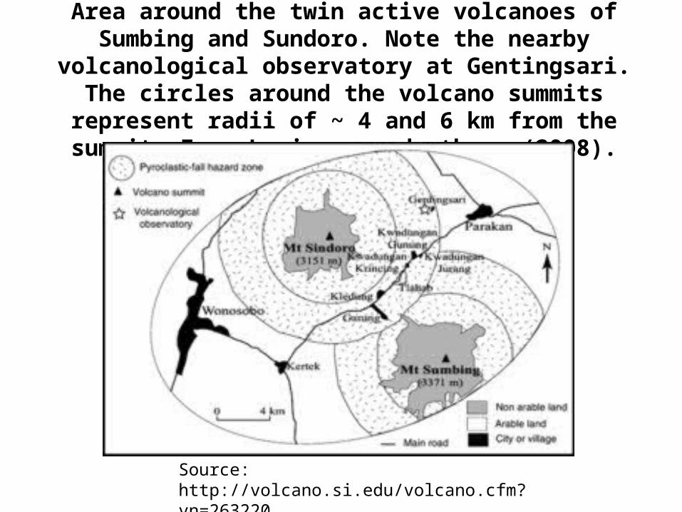
Area around the twin active volcanoes of Sumbing and Sundoro. Note the nearby volcanological observatory at Gentingsari. The circles around the volcano summits represent radii of ~ 4 and 6
km from the summit. From Lavignea and others (2008).
Source: http://volcano.si.edu/volcano.cfm?vn=263220

MOUNT SINDORO
• MT. SINDORO IS KNOWN AS MT. SINDARA or SUNDORO AND IS AN ACTIVE STRATOVOLCANO.
• ALTITUDE: 3,150 METERS or 10,395 FEET ABOVE THE MEAN SEA LEVEL AND 7.25⁰ S AND 108.058⁰ N.
• LOCATED: AT CENTRAL JAWA PROVINCE AND NEAR CITY OF PARAKAN TOWARD THE EAST AND WONOSOBO TOWARD THE WEST.
• TYPE OF VOLCANIC ERUPTION: A SMALL TO MEDIUM PHREATIC ERUPTION (an explosive eruption that occurs when water enters into the magma chamber and turns into steam).
• VOLCANIC OBSERVATION STATION: GENTINGSARI VILLAGE LOCATED AT THE EASTERN FLANK OF THE MOUNTAIN VALLEY.
Sources:http://httptheriwans.blogspot.com/2015/01/gunung-sindoro.html
http://artikelnyafety.blogspot.com/2011/02/sindoro-sumbing-twins-mountain-are.html
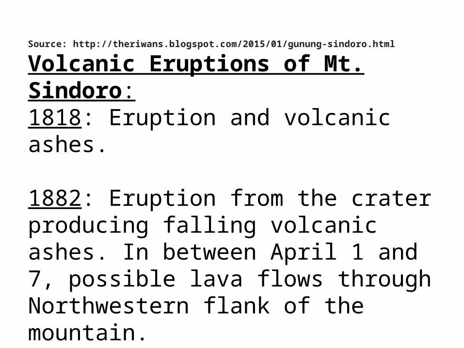
Source: http://theriwans.blogspot.com/2015/01/gunung-sindoro.html
Volcanic Eruptions of Mt. Sindoro:1818: Eruption and volcanic ashes.
1882: Eruption from the crater producing falling volcanic ashes. In between April 1 and 7, possible lava flows through Northwestern flank of the mountain.

August 1883: More volcanic activities and volcanic eruption occurred.
November 13-14, 1887: volcanic explosion.
May 1-25, 1902:small mudflow and pyroclastic flow.

October 1903: Eruption at Kembang crater and falling ashes.
1906: eruption, falling ashes that damaged crops and caused house fire.
1908: Increasing volcanic activity (buzzing sound coming from the inner mountain).
1910: The volcanic activity (buzzing sound can be heard from the city of Temanggung).
1970: Earthquake at Sigedang village followed by white smoke coming out from the summit. Then, smoke came out vertically above the crater followed by blast with thick smoke and buzzing sound. At night, smoke looked red.

November 2011: increasing volcanic activity.
November 2011 – March 2012: smoke and volcanic gases came out from the crater and crater’s wall.
December 5, 2011: volcanic activity raised from level 1 to level 2 followed by earthquakes coming from deep and shallow volcanic activities.
March 2012: volcanic activity decreased and came back to level 1.


MT. SUMBINGMT. SINDORO (3,150 METERS HIGH) AND MT. SUMBING (3340 METERS
HIGH) KNOWN AS THE TWIN VOLCANOES.
Source: http://artikelnyafety.blogspot.com/2011/02/sindoro-sumbing-twins-mountain-are.html

MT. SUMBING
• ALTITUDE: 3,340 METERS or 11,022 FEET ABOVE THE MEAN SEA LEVEL AND 7.384⁰ S and 110.992⁰ E.
• LOCATED AT CENTRAL JAVA PROVINCE AND NEAR THE CITY OF PARAKAN, TEMANGGUNG, AND WONOSOBO.
• MT. SUMBING or GUNUNG SUMBING IS AN ACTIVE STRATOVOLCANO, SYMETRICAL WITH MT. SINDORO.
• ERUPTION: SMALL PHREATIC ERUPTION AND IT HAS A VOLCANIC CRATER AT THE SUMMIT.
Sources: • http://artikelnyafety.blogspot.com/2011/02/sindoro-sumbing-twins-mountain-are.html• http://korindo-network.com/jogjakarta/indonesia-twin-volcano.htm

AMAZING TWIN VOLCANOES – MT. SINDORO & MT. SUMBING
http://korindo-network.com/jogjakarta/indonesia-twin-volcano.htm

Mt. Sumbing
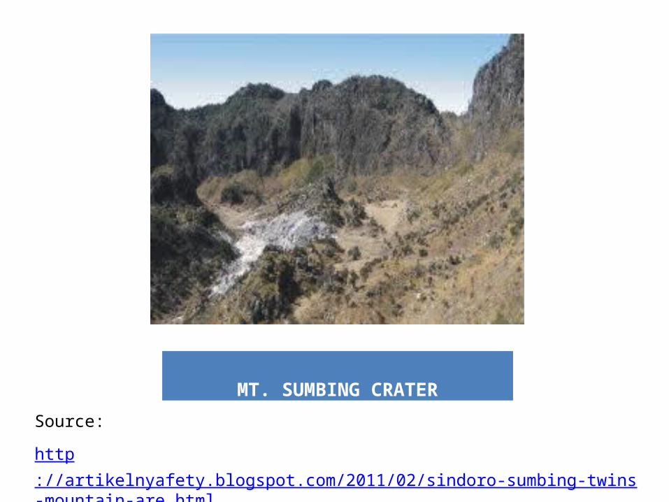
MT. SUMBING CRATER
Source:
http://artikelnyafety.blogspot.com/2011/02/sindoro-sumbing-twins-mountain-are.html

MT. GALUNGGUNG- active stratovolcano in West Java, Indonesia, approximately 80 km (50 mi) southeast of the West Java provincial capital, Bandung.
- Elevation: 2,168 meters or 7,113 feet above MSL.
- Part of the Sunda Arc extending through Sumatra, Java and Bali, which has resulted from the subduction of the Australian plate beneath the Eurasian plate.
Source: http://en.wikipedia.org/wiki/Galunggung

Lightning strikes during the 1982 eruption of GalunggungI was studying Geophyics at the Institute of Technology Bandung when this
eruption occurred, and it is located at about 50 Miles from the Mt. Galunggung.
Source: http://en.wikipedia.org/wiki/Galunggung

Mt. Galunggung Eruption in 1982
Source: http://en.wikipedia.org/wiki/Galunggung

Galunggung is a stratovolcano on the west side of the island of Java. The caldera of Galunggung is open to the southeast. Photo by Jack Lockwood, U.S.
Geological Survey, August 17, 1982.
Source: http://volcano.oregonstate.edu/galunggung

Hazardous eruption of 1982
The last major eruption on Galunggung was in 1982, which had a volcanic explosivity index (VEI) of 4. Volcanic hazards include pyroclastic flow, huge falling ash, lapilli, blast, landslide, lahar, earthquake, volcanic gases,and volcanic aerosol. The eruption lasted for 9 months.
This eruption also brought the dangers of volcanic ash to aviation to worldwide attention.
Source: http://en.wikipedia.org/wiki/Galunggung

The first historic eruption of Galunggung was in 1822. Since then the volcano has erupted four times, most recently in 1984. This photo shows a column of ash rising above the summit during the large (VEI=4)Vulcanian-type eruption. Eruption columns at Galunggung reached heights as great as 15 miles (24 km). Photo by Jack Lockwood, U.S. Geological Survey, August 16, 1982.
Source: http://en.wikipedia.org/wiki/Galunggung

ERUPTION HISTORY:Two eruptions at Galunggung have caused fatalities. During the 1822 eruption (VEI=5), and mudflows killed 4,011 people and destroyed 114 villages.
During the 1982 eruption (VEI=4) about 68 people died, mostly from indirect causes (traffic accidents, old age, cold, and lack of food). Estimated damage was $15 million and 22 villages were left uninhabitable.
The 1984 eruption was phreatic and lasted about two weeks.
Source: http://en.wikipedia.org/wiki/Galunggung

This photo shows lightning above the summit and glowing pyroclasts on the flank of Galunggung. Photo by Jack Lockwood, U.S. Geological Survey,
September 16, 1982.Source: http://en.wikipedia.org/wiki/Galunggung
Source: http://en.wikipedia.org/wiki/Galunggung

The April 1982-January 1983 eruption destroyed the 1918 lava dome and produced a new cinder cone in a new crater. The crater was about 2,000 feet (600m) across and about 1,000 feet (300 m) deep. The cone grew to 250 feet (75 m) and was 650 feet (200 m) in diameter. Photo by Jack Lockwood, U.S. Geological Survey, July 31, 1982.
Source: http://en.wikipedia.org/wiki/Galunggung
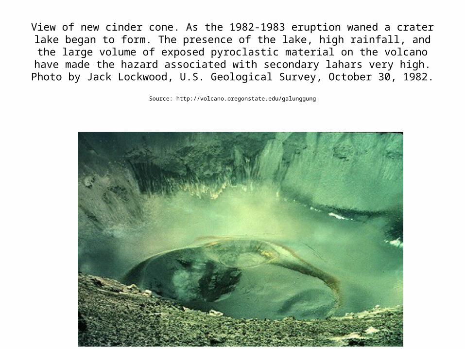
View of new cinder cone. As the 1982-1983 eruption waned a crater lake began to form. The presence of the lake, high rainfall, and the large volume of exposed
pyroclastic material on the volcano have made the hazard associated with secondary lahars very high. Photo by Jack Lockwood, U.S. Geological Survey, October
30, 1982.
Source: http://volcano.oregonstate.edu/galunggung

During the 1982 eruption two jumbo jets entered the ash clouds at an altitude of about 6 miles (10 km). Their engines stalled and windshields were abraded. Fortunately, the pilots were able to restart the engines.
Source: http://en.wikipedia.org/wiki/Galunggung

MT. MERAPI

Mt. MerapiMerapi means producing fire. ”Api” is
“fire” in Indonesian.
Historically, Mt. Merapi has shown the volcanic activities (smoke emitted
from the summit in 300 days per year). I remember when I was young, Most of the time I saw smoke coming out
from the peak of Mt. Merapi.

CITY OF YOGYAKARTA

Mt. MERAPI IN CENTAL JAVA
http://en.m.wikipedia.org/wiki/List_of_volcanoes_in_Indonesia

EXPERIENCE THE EARTHQUAKES
EXPERIENCE OF EARTHQUAKES:
Several times in the village of Gentingsari, Central Java.
Several times in Bandung, West Java.
Major Earthquake in Jakarta caused by the source of the Earthquake in the Indian Ocean
at the South of Java Island.

My Family and Home in Gentingsari Village, and My mother is standing next to me below.
