local customization of landfire fuels data on the...
TRANSCRIPT

Don Helmbrecht, Wildland Fire Analyst USFS TEAMS Enterprise Unit
Tallgrass Prairie/Oak Savanna & Lake States Fire Science Consortia
October 29, 2014
Local Customization of LANDFIRE Fuels Data on the
Huron and Hiawatha National Forests

Greg Seamon
Today: Customizing Data - Don Helmbrecht, Wildland Fire Analyst, USDA Forest Service, TEAMS Enterprise Unit. Local Customization of Fuels Data on the Huron-Manistee and Hiawatha National Forests. Previous TPOS & Lake States Consortia webinars are recorded and available: • LANDFIRE 101 – Randy Swaty’s introduction to LANDFIRE products and processes. • Assessing Needs - Tracy Hmielowski presented Where Should We Burn? A Fire Needs
Assessment for Wisconsin.
• LANDFIRE and TPOS/Lake States offered the series to talk about and illustrate LANDFIRE products and processes that can support large land management and planning.
• Others: Northwest Fire Science Consortium and the Northern/Southern Rockies Fire Science Networks
• Southern Fire Exchange series ends November 17: Curt Stripling, Geospatial Coordinator, Texas A&M Forest Service, and David Buckley, Principal Consultant, Technosylva, present Leveraging LANDFIRE for the Southern Wildfire Risk Assessment.

• Review of LANDFIRE application scale
• Common considerations
• Five-step conceptual framework
• Huron & Hiawatha examples
• Available resources & support
Presentation Overview

• Scale:
– Cartographic scale: a mathematical relationship between a given feature on a map and that feature on the ground; a ratio (e.g., 1:24,000).
– Spatial resolution: the pixel size (raster data) or MMU (polygon data).
– Application scale: specific geography for which the data can be appropriately applied without significant adjustment.
• LANDFIRE data is designed to be used “out-of-the-box” at the national, regional, or very-large landscape level.
• However, this varies by the specific application, geography/ecological and spatial complexity, and product.
LANDFIRE Application Scale

• Fire behavior fuel models are mapped using a rule-based approach.
• Rules are developed at the map zone level (range between 12 and 60 million acres).
• The “best fit” for the zone may not be the best fit for your local area.
LANDFIRE Application Scale

Common Considerations
©TNC
©Ami Vitale
Are the data current?
Is the classification system appropriate for your objectives?
Does the data contain accuracy errors?
Can the data be improved with local information?

Data Critique and Modification Process
Identify Data Requirements
Critique Modify Analyze
Define Objectives

Data Critique and Modification Process
Identify Data Requirements
Critique Modify Analyze
Define Objectives

Data Critique and Modification Process
Identify Data Requirements
Critique Modify Analyze
Define Objectives

Data Critique and Modification Process
Identify Data Requirements
Critique Modify Analyze
Define Objectives

Data Critique and Modification Process
Identify Data Requirements
Critique Modify Analyze
Define Objectives

Data Critique and Modification Process
Identify Data Requirements
Critique Modify Analyze
Define Objectives
Define Objectives Identify Data Requirements Critique Modify Analyze

Example Application
Define Objectives Identify Data Requirements Critique Modify Analyze
“Conduct wildfire behavior analysis to support forest planning and wildfire incident management, more specifically, model spatial wildfire hazard.”

Example Application
Eight geospatial data layers comprise the fire behavior modeling landscape:
• Elevation
• Aspect
• Slope
• Forest canopy cover
• Forest canopy height
• Fire behavior fuel model
• Canopy base height
• Canopy bulk density
Define Objectives Identify Data Requirements Critique Modify Analyze

Example Application
Each layer influences environmental and fire behavior characteristics:
Elevation
• Fuel moisture content
Aspect
• Fuel moisture content
• Direction of fire spread
Slope
• Fuel moisture content
• Rate of spread
Define Objectives Identify Data Requirements Critique Modify Analyze

Example Application
Forest canopy cover
• Mid-flame wind speed
• Dead fuel moisture content
Forest canopy height
• Mid-flame wind speed
• Spotting potential
Fire behavior fuel model
• Surface fire spread rate and intensity
Canopy base height
• Crown fire initiation
Canopy bulk density
• Crown fire type, intensity, and rate of spread
Define Objectives Identify Data Requirements Critique Modify Analyze

Example Application
Questions we asked:
• Are the data up to date? – Project year: 2013
– Data year: 2008
– 7,478-acre Meridian Road Fire occurred in 2010 on the Huron NF
– Huron and Hiawatha NFs’ silviculture, wildlife, and fire management programs collectively treat thousands of acres per year.
• Is modeled fire behavior representative of actual/observed fire behavior? – Fuels data have not been updated to reflect post-disturbance
conditions.
– Will use fire behavior calculators to critique fuel assignments.
Define Objectives Identify Data Requirements Critique Modify Analyze

Example Application
Data Currency – Huron National Forest:
Define Objectives Identify Data Requirements Critique Modify Analyze
LANDFIRE 2008 disturbance grid (1999-2008) New disturbances (2009-2012)

Example Application
The critique revealed new data requirements:
Burn severity of Meridian Road Fire
Type, severity, and year of treatment activities
Define Objectives Identify Data Requirements Critique Modify Analyze

Example Application
Before critiquing fuels we therefore needed to update our disturbance and canopy cover grids:
1. Update Time-Since-Disturbance for the 1999-2008 disturbances.
2. Reclassify Meridian Road fire-severity codes to LANDFIRE disturbance codes.
3. Assign LANDFIRE disturbance codes to FACTS activities data.
4. Create an updated 1999-2012 disturbance geospatial layer.
5. Reduce pre-disturbance canopy cover to reflect post-disturbance effects.
6. Create an updated 2012 canopy cover geospatial layer.
Define Objectives Identify Data Requirements Critique Modify Analyze

Example Application
LANDFIRE fuel disturbance coding:
Define Objectives Identify Data Requirements Critique Modify Analyze
Disturbance
Attribute Description
LANDFIRE
FDist Code
NA No Disturbance 0
Type
(1st digit)
Fire 1XX
Mechanical Add 2XX
Mechanical Remove 3XX
Windthrow 4XX
Insects-Disease 5XX
Exotics 6XX
Severity
(2nd digit)
Low Severity X1X
Moderate Severity X2X
High Severity X3X
Time Since
Disturbance
(3rd digit)
1 Year XX1
2-5 Years XX2
6+ Years XX3

Example Application
Define Objectives Identify Data Requirements Critique Modify Analyze
RAVG Attribute RAVG Code LANDFIRE Attribute LANDFIRE Code
Outside Perimeter 0 No Disturbance 0
Unchanged/Unburned 1 No Disturbance 0
Low-Severity 2 Fire/Low-Severity/2-5 Years TSD 112
Moderate-Severity 3 Fire/Moderate-Severity/2-5 Years TSD 122
High-Severity 4 Fire/High-Severity/2-5 Years TSD 132
1) Update Time-Since-Disturbance for the 1999 – 2008 disturbances:
2) Reclassify Meridian Road fire-severity codes to LANDFIRE disturbance codes:
Disturbance Year Pre-2004 2004 – 2007 2008
Refresh08 TSD > 5 years 2 – 5 years 1 year
Updated TSD > 5 years > 5 years 2 – 5 years

Example Application
Define Objectives Identify Data Requirements Critique Modify Analyze
Disturbance
Attribute Description
LANDFIRE
FDist Code
NA No Disturbance 0
Type
(1st digit)
Fire 1XX
Mechanical Add 2XX
Mechanical Remove 3XX
Windthrow 4XX
Insects-Disease 5XX
Exotics 6XX
Severity
(2nd digit)
Low Severity X1X
Moderate Severity X2X
High Severity X3X
Time Since
Disturbance
(3rd digit)
1 Year XX1
2-5 Years XX2
6+ Years XX3
3) Assign LANDFIRE disturbance codes to FACTS activities data:
Additional considerations for FACTS data:
• Cumulative effect of multiple activities from 2009-2012?
• Harvest method: short-wooding or whole tree?
• Site preparation method: remove activity fuel or roller chop and chain?
• Temporal variability in methods?
• Has the site been planted?

Example Application
Define Objectives Identify Data Requirements Critique Modify Analyze
2009-2012 disturbances
1999-2008 disturbances
Updated disturbance layer
4) Create an updated 1999-2012 disturbance geospatial layer.
• Spatially merge new disturbances with updated (for TSD) 1999-2008 disturbance grid.

Example Application
5) Reduce canopy cover to reflect disturbance effects:
• If available, use a measured or remote sensing canopy cover reduction product (e.g., RAVG).
• Otherwise, assign reduction factor to disturbance severity.
Define Objectives Identify Data Requirements Critique Modify Analyze
Severity Class Severity Description Reduction Factor
Low < 25% canopy reduction 12.5%
Moderate 25 – 75% canopy reduction 50%
High > 75% canopy reduction 87.5%
Example:
Canopy Cover
Range Mid-point Low Moderate High
50 – 59% 55% 48.1% 27.5% 6.9%

Example Application
Define Objectives Identify Data Requirements Critique Modify Analyze
Pre-disturbance cover
Cover reduction
Post-disturbance cover
6) Create an updated 2012 canopy cover geospatial layer
• Reduce canopy cover using a “disturbance mask.”

Example Application
Fire Behavior Fuel Model Critique
What is a FBFM?
Define Objectives Identify Data Requirements Critique Modify Analyze
Set of fuelbed characteristics: • Fuelbed depth • SAV ratio by category (live or dead) and
size class • Fuel load by category and size class • Extinction moisture content • Particle heat content
Fuel Types: • Grass • Grass/Shrub • Shrub • Timber-litter • Timber-understory • Slash/Blowdown

Example Application
• LANDFIRE FBFMs are mapped using a rule-based approach
• Fuel mapping rules identify combinations of biophysical setting, existing vegetation type and ranges of existing cover and height that would indicate a particular fuel model
Define Objectives Identify Data Requirements Critique Modify Analyze

Example Application
Requires new data: Existing vegetation type
Existing vegetation cover
Existing vegetation height
Biophysical setting
Disturbance type, severity, and time since it occurred.
Define Objectives Identify Data Requirements Critique Modify Analyze

Example Application
• LANDFIRE Total Fuel Change Tool facilitates the critique, modification, and analysis of fuels data in one tool.
Define Objectives Identify Data Requirements Critique Modify Analyze

Example Application
Where is adjustment needed?
Define Objectives Identify Data Requirements Critique Modify Analyze
Modify assignment
Modify combinations and thresholds

Example Application
Define Objectives Identify Data Requirements Critique Modify Analyze
• Rules can be added, deleted, or modified and results easily remapped with the LFTFC tool.
• By changing a threshold the spatial distribution is modified.
Spatial distribution is modified

Example Application
Define Objectives Identify Data Requirements Critique Modify Analyze
Fuel model assignment is modified
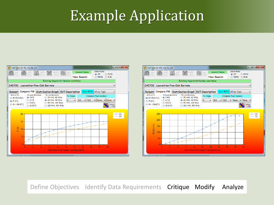
Example Application
Define Objectives Identify Data Requirements Critique Modify Analyze
Example Application
Define Objectives Identify Data Requirements Critique Modify Analyze
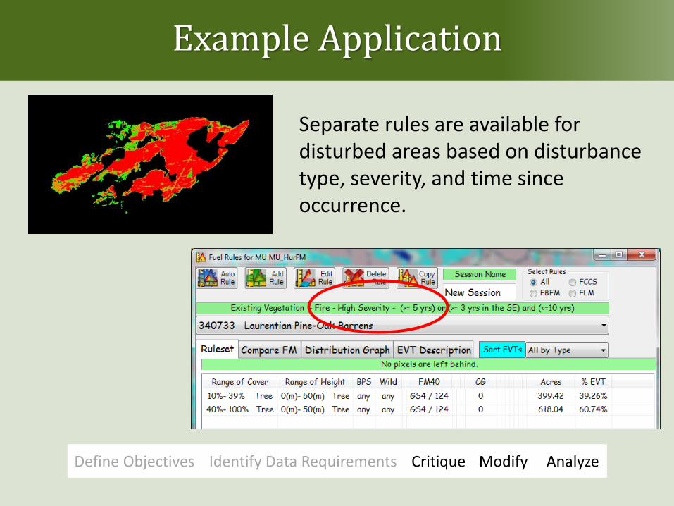
Separate rules are available for disturbed areas based on disturbance type, severity, and time since occurrence.

Example Application
Define Objectives Identify Data Requirements Critique Modify Analyze
Analysis:
• Review results to see if they pass the “straight face test.”
• Sometimes results can highlight hidden errors.

Example Application
Summary of Modification Steps:
• Updated the disturbance grid for time-since-disturbance and post-2008 disturbances.
• Updated canopy cover to reflect new disturbances.
• Critiqued FBFM mapping rules and made modifications where needed based on local expertise.
• Conducted preliminary fire behavior modeling to evaluate data modifications.

What does it take?
Expertise
Time
Expense

Resources and Support
Modifying LANDFIRE data guide www.conservationgateway.org www.frames.gov/wfmrda-ffe

LANDFIRE National www.landfire.gov
Conservation Gateway: http: //nature.ly.landfire @nature_LANDFIRE Key Word: LANDFIREvideo
Email: [email protected]
Newsletter? Just ask. Write to us.
Questions? Comments?

Questions? Comments?
Don Helmbrecht Wildland Fire Analyst USDA Forest Service TEAMS Enterprise Unit [email protected] www.fs.fed.us/teams