loggerheads neighbourhood plan...the loggerheads neighbourhood plan reflects local evidence and the...
TRANSCRIPT

Loggerheads Neighbourhood Plan
2013-2033
Version 2.19 Referendum
Foreword In September 2015 Newcastle under Lyme Borough Council, designated the Loggerheads
Neighbourhood Area. This comprised the entire area of Loggerheads Parish. Throughout
this plan, ‘Loggerheads’ refers to the entire parish and neighbourhood plan area. The term
‘Loggerheads Village’ refers to that settlement only and not the entire parish.
The production of the Neighbourhood Plan has been led by the Parish Council, with input
from residents and external consultants.
Once made, the Loggerheads Neighbourhood Plan will form part of the statutory
development plan for the area, together with the Newcastle-under-Lyme and Stoke on
Trent Core Spatial Strategy 2006 – 2026 (adopted October 2009) and the Newcastle-under-
Lyme Local Plan 2011 (adopted in 2003). The Borough Council, as the Local Planning
Authority, will have to determine planning applications in accordance with the statutory
development plan, including the Neighbourhood Plan, unless material considerations
indicate otherwise.
The Neighbourhood Plan will be in force until the end of 2033, unless it is revised and
replaced before that time.
The Loggerheads Neighbourhood Plan reflects local evidence and the comments received
from questionnaires and surveys that have been undertaken during 2015-16. It is evident
that people are happy living in the parish, but have a desire to make improvements where
appropriate. The policies set out in the Neighbourhood Plan seek to address key concerns
relating to housing, transport, heritage, economy and sport, health and community facilities.

Acknowledgements This document has been developed and produced by the Parish Council, working with a
community group of volunteers with wide ranging skills and backgrounds.
The Parish Council would like to thank the volunteers who made up the Neighbourhood Plan
Group, who gave up their time to see this project through from an idea to a finished plan.
The Parish Council and the Neighbourhood Plan Group would like to thank the whole
community for participating in the process and for coming together and supporting the
Neighbourhood Plan.
The Team would like to thank the following in preparation of the documents:
Ros Grimes for help and advice with the residents questionnaire and in writing
the Residents’ Survey Report
Rosie Duncan who was our cartographer
Andy Perkin who was our Community and Enterprise Consultant
Dave Chetwyn of Urban Vision Enterprise CIC who was our professional planning
consultant funded by the DCLG grant and the Parish Council
Helen Beech, Claire Coombs, Janet Belfield and Mark Kirk from Newcastle
Borough Council for guidance and support on matters relating to neighbourhood
planning
Staff from AECOM for the Strategic Environment Assessment

Table of Contents
Section 1: Introduction......................................................................................................................................................... 1
1.1 What is a Neighbourhood Plan? .................................................................................................................. 1
1.2 The Loggerheads Neighbourhood Plan ................................................................................................... 2
1.3 What Area does the Plan Cover? ................................................................................................................. 2
1.4 Time-scale of the Plan ...................................................................................................................................... 4
1.5 Monitoring and Revising the Plan .............................................................................................................. 4
1.6 Neighbourhood Plan Process ....................................................................................................................... 4
Section 2: Vision and Aims ................................................................................................................................................. 8
2.1 The Vision .............................................................................................................................................................. 8
2.2 Aims .......................................................................................................................................................................... 8
Section 3: Context and General Data ............................................................................................................................. 9
3.1 History of the Parish of Loggerheads ....................................................................................................... 9
3.2 Strategic Context ................................................................................................................................................ 9
3.3 Environmental Characteristics .................................................................................................................. 10
3.3.1 Settlement Features .............................................................................................................................. 10
3.3.2 Historic Character .................................................................................................................................. 10
3.3.3 Natural Character ........................................................................................................................................... 12
3.3.4 Landscape Character ............................................................................................................................ 13
3.3.5 Landscape Uses ....................................................................................................................................... 14
3.3.6 Character Assessment.......................................................................................................................... 18
3.3.7 The Importance of Open Countryside for the Parish ............................................................ 18
3.3.8 Local Green Space Designations ..................................................................................................... 19
3.4 Key Socio-Economic Data ............................................................................................................................. 20
3.4.1 Demographics .......................................................................................................................................... 20
............................................................................................................................................................................................. 21
3.4.2 Economy ..................................................................................................................................................... 21
3.4.3 Employment ............................................................................................................................................. 22
3.4.4 Health .......................................................................................................................................................... 23
3.4.5 Transport .................................................................................................................................................. 23
3.4.6 Distance to Key Services ..................................................................................................................... 24
3.5 Land Use Data .................................................................................................................................................... 25
3.5.1 Housing ....................................................................................................................................................... 25
3.5.2 Housing Need ........................................................................................................................................... 26
3.5.3 Key Routes ................................................................................................................................................. 26
3.5.4 Recreational Use/Sports Facilities ................................................................................................ 27
3.5.5 Community Facilities ............................................................................................................................ 27
Section 4: Community Engagement ............................................................................................................................ 29
4.1 The Process ......................................................................................................................................................... 29
4.2 Activities ................................................................................................................................................................ 29
4.2.1 Local Consultation ................................................................................................................................. 29
4.2.2 Statutory Consultation......................................................................................................................... 30
4.3 Key Outcomes and Issues ............................................................................................................................. 30
Section 5: Growth Strategy .............................................................................................................................................. 33
5.1 Strategy for Sustainable Growth ............................................................................................................... 33
6.1 Housing Growth ................................................................................................................................................ 36
6.1.1 Purpose ....................................................................................................................................................... 36
6.1.2 Rationale and Evidence ....................................................................................................................... 36
6.1.3 Policies ........................................................................................................................................................ 40
6.2 Housing Mix .................................................................................................................................................. 42
6.2.1 Purpose ....................................................................................................................................................... 42
6.2.2 Rationale and Evidence ....................................................................................................................... 42
6.2.3 Policies ........................................................................................................................................................ 45
6.3 Place & Heritage................................................................................................................................................ 46
6.3.1 Purpose ............................................................................................................................................................ 46
6.3.2 Rationale and Evidence ............................................................................................................................ 46
6.3.3. Policies ............................................................................................................................................................. 50
6.4 Transport & Movement ................................................................................................................................. 64
6.4.1 Purpose ....................................................................................................................................................... 64
6.4.2 Rationale and Evidence ....................................................................................................................... 64
6.4.3 Policies ........................................................................................................................................................ 66
6.5 Sport, Health & Community Facilities .................................................................................................... 68
6.5.1 Purpose ....................................................................................................................................................... 68
6.5.2 Rationale and Evidence ....................................................................................................................... 68
6.6 Economy ............................................................................................................................................................... 81
6.6.1 Purpose ....................................................................................................................................................... 81
6.6.2 Rationale and Evidence ....................................................................................................................... 81
6.6.3 Policies ........................................................................................................................................................ 84
Interpretation: .................................................................................................................................................................. 85
Section 7: Non-Neighbourhood Plan Issues ............................................................................................................ 86
7.1 Place and Heritage: To develop a case for a Conservation Area on Ashley Heath ..... 86
7.2 Place and Heritage: Encourage opportunities for improving the appearance of the
centre of Loggerheads village, including the car wash area, car sales area and bus
shelters. ................................................................................................................................................................. 86
7.3 Transport and Movement: Speak to the education and highways authorities on
problems with school parking at Hugo Meynell School .......................................................................... 87
7.4 Transport and Movement: Discuss the potential for traffic calming with the
Highways Authority .................................................................................................................................................. 87
7.5 Transport and Movement: Speak to bus service providers about improving services
.............................................................................................................................................................................. 88
7.6 Transport and Movement: Examine the potential for car sharing arrangements...... 89
7.7 Transport and Movement: Progress the project for community transport provision ..
.............................................................................................................................................................................. 89
7.8 Sport, Health & Community Facilities: Contact health providers to encourage
expansion of services in the area ....................................................................................................................... 89
7.9 Sport, Health & Community Facilities: Develop projects to improve sports,
recreation and community facilities ................................................................................................................. 90
7.10 Economy: Lobby providers to install faster broadband throughout the area ......... 91
7.11 Economy: Lobby providers to encourage improved mobile coverage ............................. 91
Index of Maps
1 Proposed Neighbourhood Plan Area for Loggerheads 3
2 Proposed Changes to Loggerheads Village Envelope 38
3 Designated village envelope for Loggerheads 39
4 Location of Scheduled Ancient Monuments, conservation areas and SSSIs in relation to village envelopes
49
5 Location of character areas 54
6 Designated local green space Tadgedale Brook, Loggerheads 56
7 Designated local green space Kestrel Drive, Loggerheads 57
8 Designated local green space Hugo Way, Loggerheads 58
9 Designated local green space Allotments behind Eccleshall Road, Loggerheads 59
10 Designated local green space Turner Hodgkiss Nature Reserve, 60
11 Designated local green space Bell Orchard Play Area, Ashley 61
12 Designated local green space Almington Play Area 62
13 Designated local green space Knighton Play Area 63
14 Location of Sports Facilities, Play Areas and Green Spaces 69
15 Location of Village Halls 71
16 Site allocated for new sports and community facilities 78
17 Location of LV1 & LV2 in relation to village of Loggerheads 79
18 Existing and Planned Broadband Coverage 83
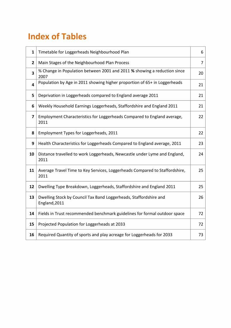
Index of Tables
1 Timetable for Loggerheads Neighbourhood Plan 6
2 Main Stages of the Neighbourhood Plan Process 7
3 % Change in Population between 2001 and 2011 % showing a reduction since 2007
20
4 Population by Age in 2011 showing higher proportion of 65+ in Loggerheads 21
5 Deprivation in Loggerheads compared to England average 2011 21
6 Weekly Household Earnings Loggerheads, Staffordshire and England 2011 21
7 Employment Characteristics for Loggerheads Compared to England average, 2011
22
8 Employment Types for Loggerheads, 2011 22
9 Health Characteristics for Loggerheads Compared to England average, 2011 23
10 Distance travelled to work Loggerheads, Newcastle under Lyme and England, 2011
24
11 Average Travel Time to Key Services, Loggerheads Compared to Staffordshire, 2011
25
12 Dwelling Type Breakdown, Loggerheads, Staffordshire and England 2011 25
13 Dwelling Stock by Council Tax Band Loggerheads, Staffordshire and England,2011
26
14 Fields in Trust recommended benchmark guidelines for formal outdoor space 72
15 Projected Population for Loggerheads at 2033 72
16 Required Quantity of sports and play acreage for Loggerheads for 2033 73

Index of Evidence All can be found at www.loggerheadsparishcouncil.co.uk
1 1a
Loggerheads Housing Needs Assessment 2016 (file name N Plan housing & pop projections amended v5 final June 16) including Appendix A Loggerheads Parish Needs Survey Report 2012.
Update to Loggerheads Housing Needs Assessment July 2017.
2 Loggerheads Neighbourhood Plan Residents survey report 2016 final
Inc. Appendix A: Loggerheads Parish Needs Survey Report 2012
3 Key Messages from Residents Survey Loggerheads
4 Business Survey Report Final Version
5 Young People’s Questionnaire 2016
6 Loggerheads Rural Place Profile ACRE, OCSI 2013
7 Character Assessment October 2016
8 Environmental Characteristics
9 Landscape use & Agricultural Land Class
10 Local Green Space Designation
11 Heritage Assets for Ashley, Loggerheads, Mucklestone and Tyrley Wards
12 Briefing note for Health and Wellbeing
13 Business case for Community Facility (file Business case AS ML v4)
14 Survey in 2014 of use of land at Market Drayton Road
15 Neighbourhood Statement Final 3
16 Annex A Neighbourhood Statement
17 Annex B Neighbourhood Statement
18 Newcastle under Lyme Council Issues Consultation Response March 2016
19 Loggerheads Feasibility Project (for community facility) Feb 2017

20 Newcastle under Lyme Borough Council Joint Local Plan evidence documents Strategic Housing Market Assessment 2015
21 NuLBC Strategic Housing Market Assessment Update 2017
22 NuLBC Strategic Housing Land Availability Assessment SHLAA 2017 Final Report
23 NuLBC Appendix A Part 1 SHLAA Site schedule
24 NuLBC Appendix A Part 2 – SHLAA Sites Assessed Excluded
25 Newcastle under Lyme Borough Council Playing Pitch Strategy Final Feb 2015
26 Newcastle under Lyme Borough Council Open Space Strategy Final 2017
27 Newcastle under Lyme Green Borough Council Infrastructure Strategy 2017
28 Newcastle-under-Lyme and Stoke on Trent Core Spatial Strategy 2006 – 2026 Final version (adopted October 2009)
29 Newcastle-under-Lyme Local Plan 2011 (adopted in 2003)
30 Saved Policies of the Newcastle under Lyme Local Plan 2011
31 Map of Saved policies for rural area 2009 (Adopted 2003)
32 Staffordshire County Council Planning for Landscape Change: Supplementary Planning Guidance to the Staffordshire and Stoke on Trent Structure Plan, 1996 – 2011 Volume 3: Landscape Descriptions
33 Aecom Loggerheads N Plan SEA Scoping Report Final
34 Aecom Strategic Environment Assessment for Loggerheads Neighbourhood Plan Oct 2017 & Aecom Revised SEA January 2018
35 Map of Broadband Coverage Summer 2016
36 Highways assessment for pressure points
37 Pre-submission consultation responses

Loggerheads Neighbourhood Plan Section 1: Introduction
1
Section 1: Introduction
1.1 What is a Neighbourhood Plan?
The Localism Act of 2011 gave new rights and powers to communities. It introduced
Neighbourhood Planning into the hierarchy of planning in England giving communities the
right to shape their future development at a local level. Once “made”, it is part of the
statutory development plan for the area and decisions must be made in accordance with
the policies of the neighbourhood plan, unless material considerations indicate otherwise.
The National Planning Policy Framework of 2012 states at paragraph 183 “Neighbourhood
Planning gives communities direct power to develop a shared vision for their
neighbourhood and deliver the sustainable development they need…Neighbourhood
Planning provides a powerful set of tools for local people to ensure that they get the right
type of development for their community. The ambition of the neighbourhood should be
aligned to the strategic needs and priorities of the wider local area”.
All Neighbourhood Plans must meet the ‘Basic Conditions’. These are:
have regard to national planning policy
contribute to achieving sustainable development
be in general conformity with strategic local policies for the area
be compatible with EU obligations.
Neighbourhood plans must also conform to human rights legislation.
In addition to being part of the statutory development plan, a Neighbourhood Plan can also
help the Parish Council decide priorities for the parish and give guidance when making
decisions on behalf of the parish. In producing a Neighbourhood Plan the Parish Council
would have to:
demonstrate extensive consultation and community engagement to ensure that
residents’ views about how they want the area to develop are fully reflected in
the submitted Neighbourhood Plan

Loggerheads Neighbourhood Plan Section 1: Introduction
2
identify and take account of local evidence, including the settlement’s history,
features, environment, demographics and socio-economic data
take into account the impact of recent planning decisions.
1.2 The Loggerheads Neighbourhood Plan
The Loggerheads Neighbourhood Plan contains policies for future development of this
parish, which occupies a significant area in the south and west of the Borough of Newcastle-
under-Lyme (the rural south), which is within the county of Staffordshire. It has borders
with Shropshire and is close to Cheshire.
The Loggerheads Neighbourhood Plan, together with the Newcastle-under-Lyme and Stoke
on Trent Core Spatial Strategy 2006 – 2026 (adopted October 2009), the Newcastle-under-
Lyme Local Plan 2011 (adopted in 2003) and the Saved Policies of the Newcastle under Lyme
Local Plan (Adopted 2003) will form the statutory development plan for the area. The
Borough Council is working on a new Joint Local Plan with Stoke on Trent which is due to be
published in 2020 and will supersede the current adopted plan. Planning applications must
be determined in accordance with the statutory development plan, unless material
considerations indicate otherwise. This gives real weight to the policies of the
Neighbourhood Plan.
1.3 What Area does the Plan Cover?
The Plan covers the whole of the parish of Loggerheads which includes the wards of Ashley,
Loggerheads, Mucklestone and Tyrley. Map 1 below shows the plan and parish boundary.
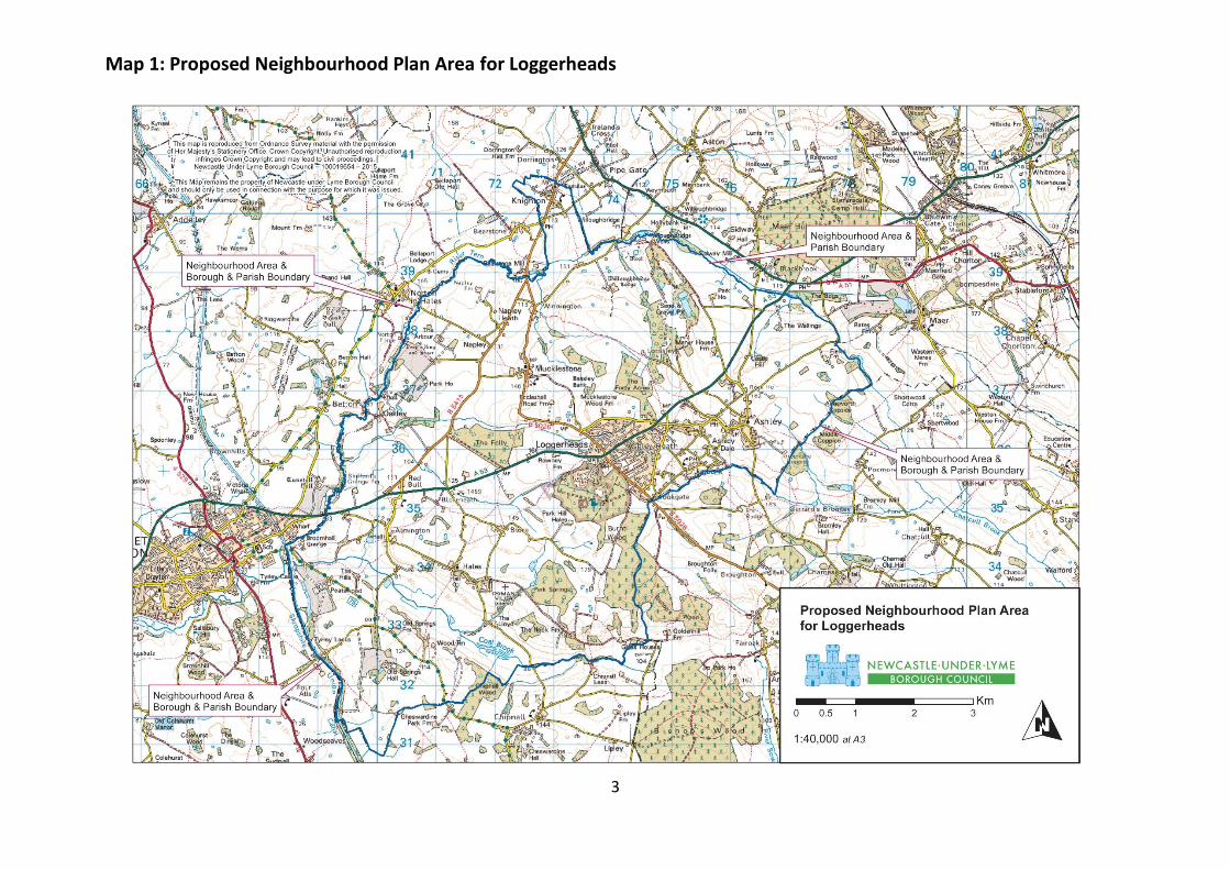
Map 1: Proposed Neighbourhood Plan Area for Loggerheads
3
Loggerheads Neighbourhood Plan Section 1: Introduction
4
1.4 Time-scale of the Plan
The duration of the Loggerheads Neighbourhood Plan is from 2013 to the end of 2033, a
period to match the period of the Joint Local Plan.
1.5 Monitoring and Revising the Plan
The Neighbourhood Plan will be reviewed following the publication of the Joint Local Plan
and then monitored by the Parish Council at intervals during the plan life, adopting a similar
cycle to the Joint Local Plan, i.e. Every 3 to 5 years as appropriate. Any revisions that are
required due to significant changes will be underpinned by an updated evidence base and
be subject to consultation with residents, businesses and other stakeholders. Details will be
published on the Parish Council website. www.loggerheadsparishcouncil.co.uk
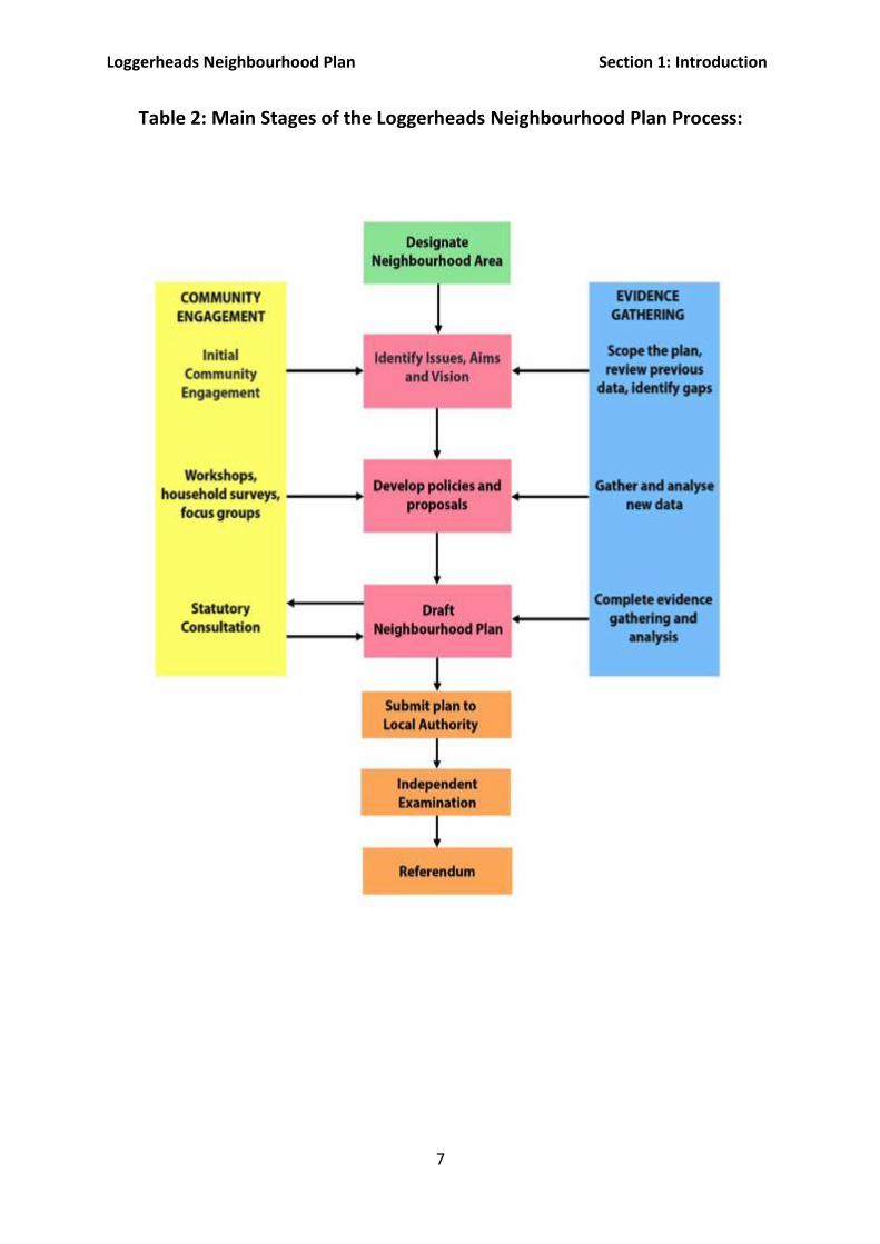
1.6 Neighbourhood Plan Process
Neighbourhood plans must be based on relevant evidence about the neighbourhood area
and must reflect the views of the local community. The Parish Council has therefore been
careful to gather the necessary evidence to inform the Neighbourhood Plan and to underpin
the policies in it.
The Neighbourhood Plan itself has been led by the Loggerheads Neighbourhood
Development Plan Steering Group, which is made up of Parish Councillors and Parishioners.
In producing the Neighbourhood Plan, the Steering Group has been supported by
neighbourhood planning specialists, Urban Vision Enterprise CIC, Aecom and a specialist in
community engagement, Andy Perkin. Throughout the process the Steering Group has
liaised with Newcastle under Lyme Borough Council, which has provided advice on key
issues such as strategic local policy and housing needs.
The Parish Council has organised and delivered many informal consultation events to gauge
local opinion at key stages in the production of the Neighbourhood Plan. In addition a draft
Neighbourhood Plan was the subject of a 6-week period of statutory consultation
(Regulation 14).

Loggerheads Neighbourhood Plan Section 1: Introduction
5
After this formal consultation period the Neighbourhood Plan Group considered all the
representations received and decided how to respond to them. This included making
appropriate modifications to the draft Neighbourhood Plan. The amended Neighbourhood
Plan, was then be submitted to Newcastle under Lyme Borough Council, along with a
Consultation Statement and a Basic Conditions Statement, explaining how the
Neighbourhood Plan satisfies the defined legal requirements.
It is the Borough Council’s duty to check whether the Neighbourhood Plan has followed the
proper legal process and that it meets the basic conditions. The Borough Council was
satisfied in this regard and publicised the Neighbourhood Plan under Regulation 16. This
invited representations from the public and from statutory consultees. At this stage
comments must focus on whether the Neighbourhood Plan satisfies the basic conditions.
Newcastle under Lyme Borough Council then appointed an independent examiner, in
agreement with the Parish Council, to consider whether the Neighbourhood Plan meets the
basic conditions.
The independent examiner prepared a report for the Borough Council which was shared
openly with the Parish Council, recommending 13 modifications. The Borough Council, in
consultation with the Parish Council, adopted the modifications and have arranged for a
referendum to take place. All people on the electoral register who live in the
Neighbourhood Area (parish of Loggerheads) will be entitled to vote in the referendum.
If more than 50% of the votes cast support the Neighbourhood Plan, then the Borough
Council will make (bring into force) the Neighbourhood Plan through a simple resolution of
the Borough Council.
Table 1 below shows the timetable followed for this plan, which has been updated several
times to account for changes. Table 2 illustrates the process that is required to be followed
for this plan. Note that this section and table 1 have been updated post examination, merely
setting out the timetable post examination and are covered by Examiner’s modification 13.

Loggerheads Neighbourhood Plan Section 1: Introduction
6
Table 1: Timetable for Loggerheads Neighbourhood Plan
Spring/Summer 2015 Publicity and early engagement
Summer 2015 Application for designation of plan area
Summer onwards Understanding the area - Data and evidence collection and interpretation
Winter 2015/Spring 2016 Residents, young people and business survey
Summer 2016 Identification of issues, vision and aims – Consultation
Summer 2016 Plan Creation - Bringing together all the evidence and consultation results
Autumn 2016 Submission of draft to Newcastle under Lyme Borough Council for screening for Environmental Impact
April 2017 Screening opinion presented to Neighbourhood Plan Group
May/October 2017 Preparation of Strategic Environmental Assessment. Review policies
Nov/Dec 2017 Draft Neighbourhood Plan Pre-Submission consultation (6 weeks) - testing proposals for the future development of the village and surrounding countryside
Dec – February 2018 Plan Amendment and Finalisation & submission to Local Authority
March/April 2018 Submission consultation (6 weeks)
September/October 2018 Habitats Regulations Screening Report amended & re-consulted on
October 2018 Examination - An Independent Examiner will test the Plan
January 2019 Referendum
Spring 2019 Adoption - Plan given full weight by Newcastle under Lyme Borough Council to determine planning applications if approved at referendum.
Loggerheads Neighbourhood Plan Section 1: Introduction
7
Table 2: Main Stages of the Loggerheads Neighbourhood Plan Process:

Loggerheads Neighbourhood Plan Section 2: Vision and Aims
8
Section 2: Vision and Aims
2.1 The Vision
The following Vision encapsulates the main issues identified by evidence on the local area
and issues raised by the community. It was important that residents felt that this statement
reflected their wishes for the parish over the lifetime of this Plan. Residents were asked to
endorse the Vision at a public forum on 7 June 2016.
2.2 Aims
The vision is supported by five aims, which are then translated into the policies of this Neighbourhood Plan.
Aim 1: Heritage & Place
To promote, protect and enhance natural and built heritage and improve access where this
does not conflict with conservation of the assets.
Aim 2: Transport & Movement
To enhance and maintain local walking routes, access to public transport and connections to
local towns and employment centres without reliance on cars.
Aim 3: Housing
To provide a sustainable place to live with a range of housing that meets local needs.
Aim 4: Health & Wellbeing
To cultivate social cohesion and healthy lifestyles through the provision of public,
recreational and community spaces.
Aim 5: Economy To provide and create an environment that is attractive to employment and visitors.
To create an enhanced sustainable rural community that provides for people of all ages

Loggerheads Neighbourhood Plan Section 3: Context and General Data
9
Section 3: Context and General Data
3.1 History of the Parish of Loggerheads
The Parish of Loggerheads was formed in 1984 as a result of the Local Government boundary
review. The three parishes of Tyrley, Mucklestone and Ashley were merged into one and this
ended an era in local government, which commenced with the original act of 1894. The history of
the villages and hamlets within the Parish goes back much further, the archaeological evidence,
mostly from stray finds, suggests human activity from the Neolithic – Bronze Age and from the
ancient site of the Roman Courtyard Villa (late first century) in Hales, to the site of the 15th
Century Battle of Blore Heath and more recently the Sanatorium at Loggerheads.
3.2 Strategic Context
Loggerheads is a civil parish of 4,790 hectares with a population in 2011 of 4,480, living in 1,860
households. It is located on the southern-most edge of Newcastle under Lyme Borough, in the
county of Staffordshire. It makes up 22.7% of the borough’s acreage and 3.6% of its population.
Together with Whitmore, Maer & Aston and Chapel Chorlton Loggerheads is referred to as the
“Rural South” by the Borough Council. It is made up of 4 wards (Ashley, Loggerheads,
Mucklestone and Tyrley) and includes the historic villages of Ashley, Knighton and Hales and the
compact and attractive hamlet of Mucklestone, which has a Conservation Area. Loggerheads
village is the biggest settlement and has developed in the last 40 years around what was the
Loggerheads Hotel and the Cheshire Sanatorium.
The rural villages, with limited local employment, make it a residential commuter base with
reasonable road links to centres of employment in Stoke, Crewe, Stafford and further afield. The
A53 runs through the parish from North Staffordshire to Shropshire. The south east border of the
parish is the county boundary and the Shropshire Union Canal. The area is mainly agricultural
land, with some large tracts of woodland. There is a small scale retail centre in Loggerheads
village. The area is abundant with well used public footpaths and horse tracks.

Loggerheads Neighbourhood Plan Section 3: Context and General Data
10
3.3 Environmental Characteristics
3.3.1 Settlement Features
The villages of Mucklestone, Knighton, Hales and Ashley have developed over centuries and
residents are keen to ensure that significant developments in these areas would enhance and not
be detrimental to the heritage and landscape quality of the area. Loggerheads village has seen
significant growth in the past 20 years and residents are keen to see that a measured pace of
growth continues so that village services and infrastructure can keep up with demand.
Loggerheads village clearly developed along the main roads to settlements in Newcastle and
Shrewsbury.
3.3.2 Historic Character
The majority of present-day villages and hamlets within the plan area date from before the
Domesday Survey of 1086. These are:
Ashley Tyrley
Mucklestone Almington
Knighton Oakley
Winnington
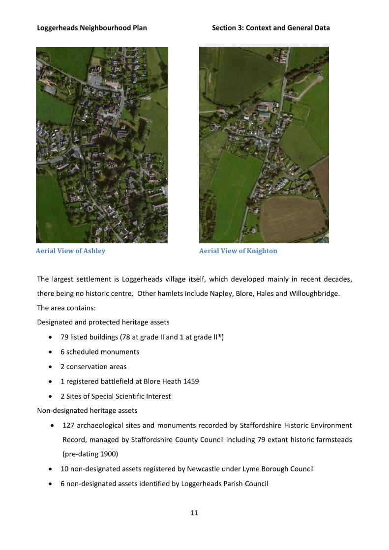
Aerial View of Loggerheads village
Loggerheads Neighbourhood Plan Section 3: Context and General Data
11
The largest settlement is Loggerheads village itself, which developed mainly in recent decades,
there being no historic centre. Other hamlets include Napley, Blore, Hales and Willoughbridge.
The area contains:
Designated and protected heritage assets
79 listed buildings (78 at grade II and 1 at grade II*)
6 scheduled monuments
2 conservation areas
1 registered battlefield at Blore Heath 1459
2 Sites of Special Scientific Interest
Non-designated heritage assets
127 archaeological sites and monuments recorded by Staffordshire Historic Environment
Record, managed by Staffordshire County Council including 79 extant historic farmsteads
(pre-dating 1900)
10 non-designated assets registered by Newcastle under Lyme Borough Council
6 non-designated assets identified by Loggerheads Parish Council
Aerial View of Ashley Aerial View of Knighton

Loggerheads Neighbourhood Plan Section 3: Context and General Data
12
A book showing all of these heritage assets has been produced and can be viewed by ward on the
parish council website www.loggerheadsparishcouncil.co.uk
The area is skirted to the West by Telford’s Shropshire Union Canal, built in 1835 and notable for
its extensive use of embankments and cuttings. The natural watercourses comprise the Coal
Brook, which rises at a spring near Bishop’s Wood in the East of the area and flows under the canal
aqueduct to join the River Tern at Market Drayton. The Tadgedale Brook, formerly Bloredale
Brook, which rises to the East of Loggerheads and joins the River Tern near Shifford’s Grange and
the Hempmill Brook which flows through the Blore Heath battle site and also joins the Tern. The
River Tern flows from its source at Maer in the neighbouring parish to the east and extends some
30 miles to join the River Severn near Attingham.
3.3.3 Natural Character
There is a Site of Scientific Interest (SSSI) in the Burntwood in Loggerheads village, comprised of
several ancient woodland blocks within a wider area of ancient woodland. Ancient woodlands
have been in situ since at least 1600 and are among the rarest and most diverse habitats in Britain
and are considered irreplaceable. Loggerheads Parish boasts a significant group of these
woodlands many of which are designated as Local Wildlife Sites and which complement SSSIs in
protecting biodiversity. The Parish is within the wooded Quarter Ecosystem Area in the
Tyrley Top Lock on the Shropshire Union Canal

Loggerheads Neighbourhood Plan Section 3: Context and General Data
13
Staffordshire Biodiversity Action Plan where the priorities are to protect, expand and join up
native woodland and wood pastures and parkland. Maintaining and enhancing the hedgerow
network contributes to linking woodlands together and allowing rare and protected species to
move through the landscape to feed and to breed.
3.3.4 Landscape Character
Staffordshire County Council’s ‘Planning for Landscape Change: Supplementary Planning Guidance
to the Staffordshire and Stoke on Trent Structure Plan, 1996 – 2011 identifies two Landscape
Character Types within the Plan area, Sandstone Hills and Heath (Farmland and Estateland
variants) and Sandstone Estatelands. The Sandstone Hills and Heaths types occupy higher, often
strongly undulating ground to the south of the area, with characteristic intimate steep sided
wooded valleys; small woodlands and copses; and ancient narrow sunken lanes with sandstone
banks. The more open Sandstone Estatelands lies in the west of the Plan area, and is an area of
more intensive arable farming, again with woodland cover but where hedges are in decline and
being lost and where there are more open views.
Volume 3: Landscape Descriptions identifies the parish of Loggerheads as being within the
Woodland Quarter of the Staffordshire Plain. The undulating landform is a unifying feature; to the
west of the core area, approaching the boundary with north Shropshire, it supports a medium
scale landscape with an intact field pattern and conifer woodlands on a pronounced rolling
landform. To the south it develops into an elevated plateau of intensive farmland and dispersed
hamlets. This is an area of scattered woods and regular to semi-regular medium sized fields. The
mixed arable and pastoral farming, with few trees, sculpted hedges and strong landform, results in
extensive views across the landscape. Broadleaved woodlands have more effect in dictating scale
in these areas, though never enough to interrupt views across them. Small winding lanes are a
general feature of the Quarter.
There is some evidence for prehistoric and Roman settlement, but the irregular field pattern, the
lack of nucleated villages and the preponderance of woodland-type names all suggest that the
present landscape is the result of gradual colonisation of an area that was once wooded. No
particular date can be determined for this colonisation, but it may have continued up until the

Loggerheads Neighbourhood Plan Section 3: Context and General Data
14
early modern period. In effect, it may have ended with the final enclosure, by agreement or by
Act, of the remaining open heaths and commons.
There are large Forest Enterprise woodlands, mainly of Corsican Pine at the Burntwood. The
Burntwood is an ancient woodland site; a semi-natural remnant of former simple oak coppice with
both native species and hybrids surviving.
Planning for Landscape Change assigned policy objectives, derived from the assessment of factors
such as representation and condition of characteristic landscape features, time depth, and the
occurrence of semi-natural habitat. Much of the Plan area falls within policy objectives of
Landscape Maintenance and Active Landscape Conservation, indicating strong representation of
characteristic features in good condition. In addition much of the Plan area to the south and west
of Loggerheads village and around and to the east of Ashley were identified of highest sensitivity
to change. This supports objectives of landscape protection and enhancement.
3.3.5 Landscape Uses
Of the 4,790 hectares total area, around 4,100, or in excess of 85%, comprise agricultural land.
There is no Grade 1 agricultural land, 25% is Grade 2, 65% is Grade 3 and 10% is Grade 4. The
settled areas account for around 220 hectares, or less than 5%, while woodland occupies 420
hectares (9%) of which 280 hectares are ancient or early woodland (6%) and 140 hectares are
plantations (3%). Areas affected by mineral extraction account for less than 1%. Maps showing
the main landscape uses present in the plan area can be seen on the Parish Council website
www.loggerheadsparishcouncil.co.uk
All land outside the settlement boundaries of the main villages is classified by the planning
authority as “open countryside” and afforded some protection from non-agricultural development
under saved policies of the Newcastle under Lyme Local Plan 2011 H1 and N17. About 90% of the
parish’s 4,790 hectares is in this category (open countryside) but less than 20% of the dwellings
are outside settlement boundaries.
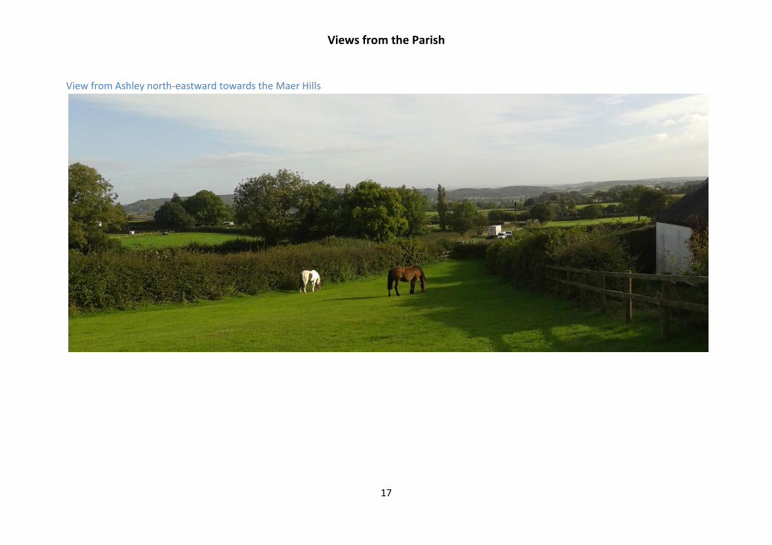
The area benefits from a number of stunning landscape views across Shropshire to the Wrekin and
the Welsh mountains and across Staffordshire to the South and to the Maer Hills to the East.

Loggerheads Neighbourhood Plan Section 3: Context and General Data
15
There are a range of circular walks, which take advantage of those views, further routes are under
development. These are actively promoted by the Parish Council.

Views from the Parish
16
View from Hales south west towards Telford
View from White House Farm, Loggerheads across Shropshire to the Welsh Hills
Views from the Parish
17
View from Ashley north-eastward towards the Maer Hills
Loggerheads Neighbourhood Plan DRAFT Section 3: Context and General Data
18
3.3.6 Character Assessment
As part of the evidence for the Neighbourhood Plan, the Neighbourhood Plan Group
undertook a character assessment for the neighbourhood plan area, i.e. the parish. The first
step was to identify the broad character areas that exist in the local area. Character areas
can be described as areas that have their own distinctive, individual character or “sense of
place”. They are areas which share a similar appearance and feel as each other. The Group
identified 6 character areas; Loggerheads village(1), Ashley Heath (2), Ashley village (3),
Tyrley Conservation Area (4), Mucklestone Conservation Area (5). The rest of the parish has
been combined into one overarching character area (6). These are described in full and can
be found on the Parish Council website.
3.3.7 The Importance of Open Countryside for the Parish
The relatively unspoiled open countryside of the parish is important for the following
reasons:
The good network of public footpaths and quiet lanes (extending over fifty
kilometres within the parish boundaries and with links further afield) provide a
much-appreciated amenity for residents and visitors.
Though the contribution of farming to the local economy and employment has
decreased in recent decades, the continuation of farming is essential if the
attractive and historic character of the landscape is to be preserved.
The identity and individuality of the villages would be diminished if green land
separating them from adjoining settlements were to be built over. The gap is
now quite small between Ashley and Loggerheads village.
A valuable resource drawing in visitors such as cyclists and walkers who spend
time in the area and contribute to the rural economy.
To enhance the views and settings of the villages for the benefit or residents and
visitors.

Loggerheads Neighbourhood Plan DRAFT Section 3: Context and General Data
19
3.3.8 Local Green Space Designations
This Neighbourhood Plan has designated local green spaces. The National Planning Policy
Framework states:
“Local Green Space designation is a way to provide special protection against
development for green areas of particular importance to local communities”.
The criteria for designating Local Green Space in Neighbourhood Plans is set out in
Paragraph 77 of the NPPF:
“The Local Green Space designation will not be appropriate for most
green areas or open space. The designation should only be used:
where the green space is in reasonably close proximity to the
community it serves;
where the green area is demonstrably special to a local
community and holds a particular local significance, for example
because of its beauty, historic significance, recreational value (including
as a playing field), tranquility or richness of its wildlife; and
where the green area concerned is local in character and is not an
extensive tract of land”.
In addition to these criteria, National Planning Practice Guidance states:
“Local Green Space designation will rarely be appropriate where the
land has planning permission for development. Exceptions could be
where the development would be compatible with the reasons for
designation or where planning permission is no longer capable of being
implemented”.
The green space assessment that led to the designations is on the website
http://www.loggerheadsparishcouncil.co.uk/Pages/116/Evidence+for+the+Plan
File: Local Green Space Designations V3.pdf

Loggerheads Neighbourhood Plan DRAFT Section 3: Context and General Data
20
3.4 Key Socio-Economic Data
Unless otherwise stated, all of the data referred to in this section is taken from a
Community profile for Loggerheads Parish ACRE, OCSI 2013 and relates to the 2011 census.
3.4.1 Demographics
There were 4,480 people living in the parish of Loggerheads at the 2011 census. This was
6.8% more than in 2001 (4,193). Population growth has been slowing down since 2007.
Table 3 below demonstrates this.
Table 3: % Change in Population from 2001 -2011 showing a reduction since 2007
There is a higher proportion of residents aged 65+ than the Staffordshire or England average
and a lower proportion of children aged 0-15. There has been a significant reduction in the
number of people age 30-44 (-11.6%) and a significant increase in the number aged over 60
(+53.8%) between 2001 and 2011. This is shown in table 4 below.
0%
2%
4%
6%
8%
10%
12%
2001 2002 2003 2004 2005 2006 2007 2008 2009 2010 2011
Change o
ver tim
e fr
om
2001
% change in total population from 2001-2011
Loggerheads Staffordshire England

Loggerheads Neighbourhood Plan DRAFT Section 3: Context and General Data
21
Table 4: Population by Age 2011 showing higher proportion of 65+ in Loggerheads
3.4.2 Economy
Loggerheads is less deprived than other areas and the average weekly household earnings
are significantly higher. Table 5 and 6 below demonstrate this.
Table 5: Deprivation in Loggerheads compared to England average 2011
Source: IMD 2010 (CLG), Working age Benefits (DWP Aug-12), Multiple deprivation (Census 2011)
Table 6: Weekly Household Earnings in Loggerheads, Staffordshire and England 2011
Number of people living in the most
deprived 20% of areas in England
Working-age DWP benefit
claimants
Households experiencing
multiple deprivation (1)
0 277 0
- 9.8% of working age adults
(England average = 13.9%)
0.0% of households (England
average = 0.5%)
16.9 17.7 18.9
63.1 63.8 64.7
20.0 18.5 16.3
0%
20%
40%
60%
80%
100%
Loggerheads Staffordshire England
% o
f to
tal p
op
ula
tio
n
Aged 0-15 Working age Aged 65+
Population by age
16.9 17.7 18.9
63.1 63.8 64.7
20.0 18.5 16.3
0%
20%
40%
60%
80%
100%
Loggerheads Staffordshire England
% o
f to
tal pop
ula
tion
Aged 0-15 Working age Aged 65+
Population by age
£790
£638£673
£510
£397£423
0
100
200
300
400
500
600
700
800
900
Loggerheads Staffordshire England
(£)
Total weekly household income estimate Net weekly household income estimate after housing costs
Weekly household earnings (£)

Loggerheads Neighbourhood Plan DRAFT Section 3: Context and General Data
22
3.4.3 Employment
There is a higher proportion of economically inactive residents (retired) and a higher
proportion of people who are self-employed and work from home; a lower proportion of
people who are unemployed (claiming job seekers allowance, 1.4% of working age adults
compared to 3.8% in England). Table 7 shows this information.
Table 7: Employment Characteristics for Loggerheads Compared to England
average 2011
The most recently available census shows that in 2011, 66.7% of Loggerheads residents
were economically active compared to 69.9% in England. 52% of Loggerheads economically
active residents were working in the sectors shown in Table 8 below, many outside the
Parish. Only 4% work in agriculture.
Table 8: Employment Types in Loggerheads, 2011
Source: ONS, Census 2011
Economically active
residents
Economically
inactive residents Full-time employees Part-time employees
2,254 1,126 1,185 440 66.7% of people aged
16-74 (England
average = 69.9%)
33.3% of people aged
16-74 (England
average = 30.1%)
35.1% of people aged
16-74 (England
average = 38.6%)
13.0% of people aged
16-74 (England
average = 13.7%)
Self-employed Working 49+ hours
per week Working from home
Employed in the
public sector
448 443 235 635 13.3% of people aged
16-74 (England
average = 9.8%)
20.6% of people in
employment (England
average = 13.3%)
7.0% of people aged
16-74 (England = 3.5%)
29.6% of 2,070 people
in employment
(England = 28.2%)
Employment Type %
Retail 16.7
Health and social work 12.8
Education 12.0
Manufacturing 10.8

Loggerheads Neighbourhood Plan DRAFT Section 3: Context and General Data
23
3.4.4 Health
There is a higher than average percentage of residents with a limiting long-term illness
(aged 16-64) which will have an impact on local health services. There is a medical centre in
Ashley which does not have capacity to register all residents; as a consequence many
register with Market Drayton Primary Care Trust (5 miles distant and in Shropshire) or
Madeley Health Centre (7 miles distant). Additionally, because patients are being treated by
Shropshire Health they are required to travel excessive distances for Hospital appointments
e.g. Oswestry for Orthopaedic care. All of this is compounded by poor public transport links.
For the future, additional capacity is urgently required in the area, either by increasing the
Ashley capacity or with an additional facility to service the Loggerheads community. Table 9
shows health characteristics for Loggerheads.
Table 9: Health Characteristics for Loggerheads Compared to England
Average, 2011
Number of people living
in health deprivation
“hotspots”
People with a limiting
long-term illness (aged
16-64)
Attendance
Allowance claimants
(aged 65+)
Disability Living
Allowance
claimants
0 390 115 215
-
13.8% of people aged 16-
64 (England= 12.8%)
12.8% of people aged
65+ (England average
= 16.7%)
4.8% of the
population (England
average = 5.1%)
3.4.5 Transport
There are typically fewer jobs in rural areas than urban, and those local jobs are often
lower-paid than their urban counterparts. Many rural communities act as “commuter
villages”, providing a higher quality of life for residents who commute to urban areas for
work; although there can also be large numbers of people working from home.
Understanding how far people travel to work may help identify actions based on potential
demand for local employment. The profile for Loggerheads is in table 10 below. Almost
double the number of people work from home (14%) compared to the national average
(8.7%), but there has been a reduction locally and nationally in this number. Only 21%
Source: Indices of Deprivation 2010 Health domain, Limiting long-term illness (Census 2011), Attendance Allowance/Disability Living Allowance (DWP Aug-12)
Loggerheads Neighbourhood Plan DRAFT Section 3: Context and General Data
24
travel less than 10km to work compared to the Newcastle under Lyme average of 60%.
Over double the Newcastle average travel up to 30km to work.
Only 1.3% of people in Loggerheads travel to work by public transport compared to 11.0% in
England. 82% travel by car. This is not necessarily by choice; public transport serving the
area is limited. There is one bus service that runs hourly Monday to Saturday from 7am till
7pm from Market Drayton to Newcastle under Lyme.
Table 10: Distance Travelled to Work, Loggerheads, Newcastle under Lyme and England 2011
Location of work Loggerheads Newcastle under Lyme
England
Less than 10km 21.2% 60.3% 52.3%
10km to less than 30km 50.8% 16.5% 21%
30km and over 9.7% 7.6% 8%
Work mainly at or from home 14.0% 8.7% 10.3%
Other 4.2% 6.9% 8.5%
Average distance travelled to work 20km 14.1km 14.9km
Source: ONS, Census 2011
3.4.6 Distance to Key Services
Access to services is a major factor in quality of life for people in rural communities, where
services and amenities may be some distance away. This is especially likely to cause
difficulties for people without cars or who are unable to drive, whose mobility is limited, and
in areas where public transportation is poor.
Many rural communities have identified a lack of facilities and amenities as a priority locally.
These facilities might include leisure facilities and meeting places for young people. Table
11 below shows the average travel time by public transport or walking to a range of
services.
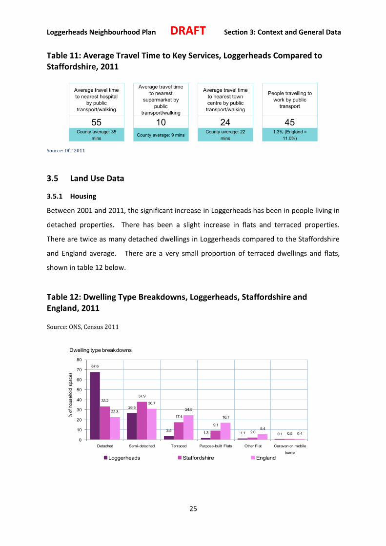
Loggerheads Neighbourhood Plan DRAFT Section 3: Context and General Data
25
Table 11: Average Travel Time to Key Services, Loggerheads Compared to Staffordshire, 2011
Average travel time
to nearest hospital
by public
transport/walking
Average travel time
to nearest
supermarket by
public
transport/walking
Average travel time
to nearest town
centre by public
transport/walking
People travelling to
work by public
transport
55 10 24 45 County average: 35
mins County average: 9 mins
County average: 22
mins
1.3% (England =
11.0%)
Source: DfT 2011
3.5 Land Use Data
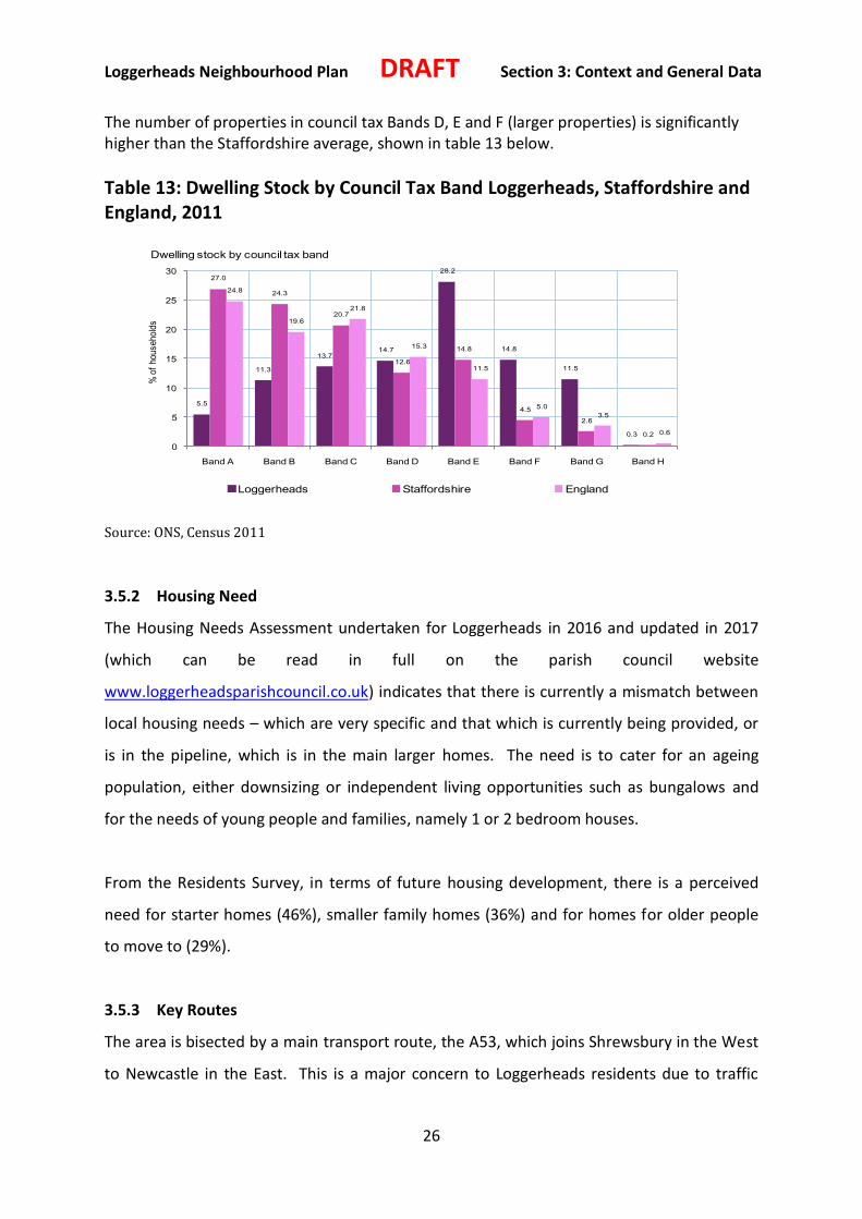
3.5.1 Housing
Between 2001 and 2011, the significant increase in Loggerheads has been in people living in
detached properties. There has been a slight increase in flats and terraced properties.
There are twice as many detached dwellings in Loggerheads compared to the Staffordshire
and England average. There are a very small proportion of terraced dwellings and flats,
shown in table 12 below.
Table 12: Dwelling Type Breakdowns, Loggerheads, Staffordshire and England, 2011 Source: ONS, Census 2011
67.6
26.5
3.51.3 1.1 0.1
33.2
37.9
17.4
9.1
2.0 0.5
22.3
30.7
24.5
16.7
5.4
0.4
0
10
20
30
40
50
60
70
80
Detached Semi-detached Terraced Purpose-built Flats Other Flat Caravan or mobile
home
% o
f hou
seho
ld s
pac
es
Loggerheads Staffordshire England
Dwelling type breakdowns
Loggerheads Neighbourhood Plan DRAFT Section 3: Context and General Data
26
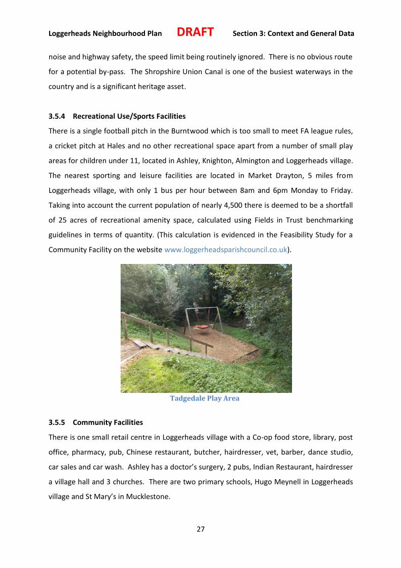
The number of properties in council tax Bands D, E and F (larger properties) is significantly higher than the Staffordshire average, shown in table 13 below.
Table 13: Dwelling Stock by Council Tax Band Loggerheads, Staffordshire and England, 2011
Source: ONS, Census 2011
3.5.2 Housing Need
The Housing Needs Assessment undertaken for Loggerheads in 2016 and updated in 2017
(which can be read in full on the parish council website
www.loggerheadsparishcouncil.co.uk) indicates that there is currently a mismatch between
local housing needs – which are very specific and that which is currently being provided, or
is in the pipeline, which is in the main larger homes. The need is to cater for an ageing
population, either downsizing or independent living opportunities such as bungalows and
for the needs of young people and families, namely 1 or 2 bedroom houses.
From the Residents Survey, in terms of future housing development, there is a perceived
need for starter homes (46%), smaller family homes (36%) and for homes for older people
to move to (29%).
3.5.3 Key Routes
The area is bisected by a main transport route, the A53, which joins Shrewsbury in the West
to Newcastle in the East. This is a major concern to Loggerheads residents due to traffic
5.5
11.3
13.714.7
28.2
14.8
11.5
0.3
27.0
24.3
20.7
12.6
14.8
4.5
2.6
0.2
24.8
19.6
21.8
15.3
11.5
5.0
3.5
0.6
0
5
10
15
20
25
30
Band A Band B Band C Band D Band E Band F Band G Band H
% o
f h
ou
se
ho
lds
Loggerheads Staffordshire England
Dwelling stock by council tax band
Loggerheads Neighbourhood Plan DRAFT Section 3: Context and General Data
27
noise and highway safety, the speed limit being routinely ignored. There is no obvious route
for a potential by-pass. The Shropshire Union Canal is one of the busiest waterways in the
country and is a significant heritage asset.
3.5.4 Recreational Use/Sports Facilities
There is a single football pitch in the Burntwood which is too small to meet FA league rules,
a cricket pitch at Hales and no other recreational space apart from a number of small play
areas for children under 11, located in Ashley, Knighton, Almington and Loggerheads village.
The nearest sporting and leisure facilities are located in Market Drayton, 5 miles from
Loggerheads village, with only 1 bus per hour between 8am and 6pm Monday to Friday.
Taking into account the current population of nearly 4,500 there is deemed to be a shortfall
of 25 acres of recreational amenity space, calculated using Fields in Trust benchmarking
guidelines in terms of quantity. (This calculation is evidenced in the Feasibility Study for a
Community Facility on the website www.loggerheadsparishcouncil.co.uk).
3.5.5 Community Facilities
There is one small retail centre in Loggerheads village with a Co-op food store, library, post
office, pharmacy, pub, Chinese restaurant, butcher, hairdresser, vet, barber, dance studio,
car sales and car wash. Ashley has a doctor’s surgery, 2 pubs, Indian Restaurant, hairdresser
a village hall and 3 churches. There are two primary schools, Hugo Meynell in Loggerheads
village and St Mary’s in Mucklestone.
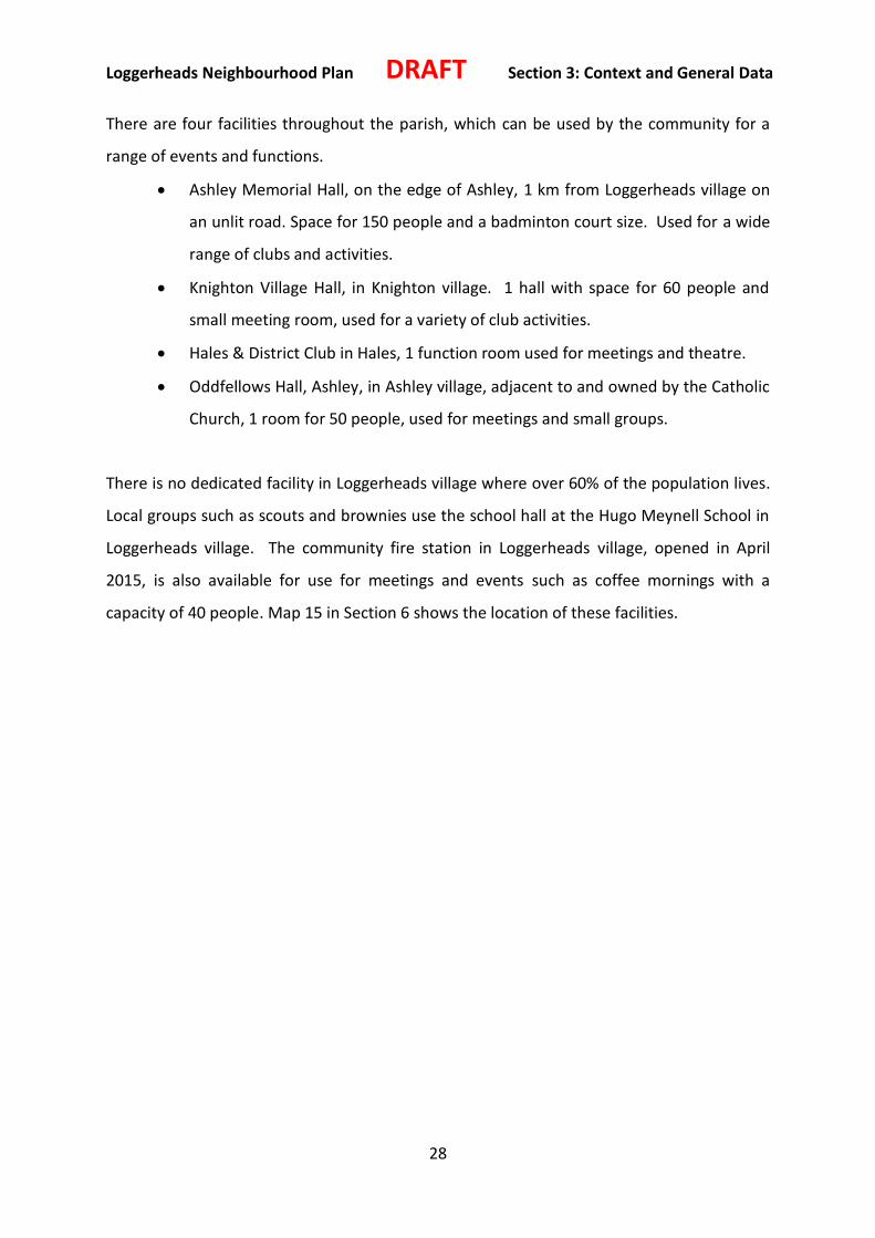
Tadgedale Play Area
Loggerheads Neighbourhood Plan DRAFT Section 3: Context and General Data
28
There are four facilities throughout the parish, which can be used by the community for a
range of events and functions.
Ashley Memorial Hall, on the edge of Ashley, 1 km from Loggerheads village on
an unlit road. Space for 150 people and a badminton court size. Used for a wide
range of clubs and activities.
Knighton Village Hall, in Knighton village. 1 hall with space for 60 people and
small meeting room, used for a variety of club activities.
Hales & District Club in Hales, 1 function room used for meetings and theatre.
Oddfellows Hall, Ashley, in Ashley village, adjacent to and owned by the Catholic
Church, 1 room for 50 people, used for meetings and small groups.
There is no dedicated facility in Loggerheads village where over 60% of the population lives.
Local groups such as scouts and brownies use the school hall at the Hugo Meynell School in
Loggerheads village. The community fire station in Loggerheads village, opened in April
2015, is also available for use for meetings and events such as coffee mornings with a
capacity of 40 people. Map 15 in Section 6 shows the location of these facilities.

Loggerheads Neighbourhood Plan Section 4: Community Engagement
29
Section 4: Community Engagement
4.1 The Process
The Loggerheads Neighbourhood Plan was produced by the Parish Council and members of
the community. In August 2015 residents were given information on Neighbourhood
Planning and asked if they wished to take this opportunity to plan proactively for the
challenges of the future. There was unanimous agreement to draw up a Neighbourhood
Plan so that the community could ensure gradual, sustainable development to allow the
local infrastructure and facilities to keep pace with the additional demands more housing
will create. Over the next few months the Parish Council set about investigating what was
required to produce a robust, evidence-based Neighbourhood Plan. Newsletters and the
Parish Council website were used to publicise the process and several requests were made
for volunteers from the community to participate in the exercise. The Parish Council
applied for designation of the neighbourhood area, which was granted in September 2015.
In October 2015 the first meeting of the Neighbourhood Plan Steering Group was held,
made up of 9 Parish Councillors and 9 volunteers, formed to oversee the development of
the Plan. Its contents reflect the views of the community following surveys and extensive
consultation over the period.
4.2 Activities
4.2.1 Local Consultation
The Neighbourhood Plan belongs to the residents of the parish of Loggerheads. It has been
developed from the views of the local people gathered using a variety of different
consultation approaches including meetings, presentations, interactive workshops, the
Parish Council website, village-wide on-line surveys and paper surveys. A separate survey of
young people was undertaken at both primary schools in the parish. In addition local
businesses were asked to complete a survey, either paper-based or on‐line. The Steering
Group has worked closely with neighbouring parishes and Newcastle under Lyme Borough
Council. Staffordshire County Council, health and social housing providers have all been
consulted.
The following are some of the reference documents to the Neighbourhood Plan:

Loggerheads Neighbourhood Plan Section 4: Community Engagement
30
pre-existing Loggerheads documents including the Parish Plan 2008 and the
Neighbourhood Statement 2012
Housing Needs Assessment 2016 & update 2017
4.2.2 Statutory Consultation
There have been several key stages of statutory consultation affording a wide range of
consultees the opportunity to have a say about the Plan.
Designation: When the Parish Council applied for designation of the Neighbourhood Area
the Local Authority undertook a 6-week consultation, which was publicised locally and
borough-wide. The feedback received has been used to inform the plan.
Pre-submission Consultation: The Neighbourhood Plan has been submitted for consultation
to the list of statutory and other bodies provided by Newcastle under Lyme Borough Council
as required under Regulation 14, Town and Country Planning, England Neighbourhood
Planning Regulations (General) 2012. The draft Plan was also made available to residents by
email and at drop-in’s at the library and fire station. Responses have been fully documented
in the Consultation Statement which can be viewed on the Parish Council website.
Submission Consultation: Following submission of the Neighbourhood Plan the Borough
Council will consult with all statutory consultees (Regulation 16).
4.3 Key Outcomes and Issues
Residents Survey – The survey was delivered to every household in the parish. 511
responses were received from 470 households (14% of the adult population and 27% of
households). Of those responding:
64% say the best thing about the area is the rural nature, countryside and scenery,
which the Neighbourhood Plan Group has termed the “ruralness” of Loggerheads
The worst thing is the appearance of the centre of the village of Loggerheads, too
many/proposed developments, lack of facilities and traffic and transport issues
An overwhelming 95% are happy living in the area
70% acknowledge a need for change
Loggerheads Neighbourhood Plan Section 4: Community Engagement
31
Residents identify a shortfall in leisure facilities, health facilities, equipped
recreational space and something for young people to do
In terms of future housing development 80% of residents hold the view that small
scale development would be acceptable
New development needs to be conditional on the provision of infrastructure (71%),
improvements to roads (66%) and provision of facilities (55%)
There is a perceived need for starter homes (46%), smaller family homes (36%) and
for homes for older people to move to (29%)
The traffic related concerns include speeding on the roads (69%), road layout and
junctions (49%) and parking, specifically in relation to the school in Loggerheads
(32%).
Young People’s Survey – 109 responses from young people aged between 8 and 11 years.
79% of young people cited the environment as the thing they like best about Loggerheads.
Specifically this included the play areas and the Burnt Wood, facilities such as the fire station
and a recurring comment was that it was small and friendly. 32% of young people cited
improved open spaces as their priority for example protecting the open spaces and not
building houses on them, together with 16% who specifically think the car wash should be
got rid of. 15% would like to see more sport and leisure facilities such as a swimming pool
and upgrading the football pitch at the Burnt Wood while 17% would like to see more shops
and food outlets.
The Business Survey which was delivered to every household as an attachment to the
Residents survey, achieved responses from 70 residents, in relation to 75 businesses. Some
60% of the businesses were operated from home, 5% from premises within the Parish and
the remaining 35% from premises outside the Parish. Businesses run from home were in:
Loggerheads 56%, Mucklestone 24%, Ashley 16% and Tyrley 4%. 40% employ no staff at all
and this is much more likely where the business is run from home. Businesses based outside
the Loggerheads area tend to be larger with more than 40% of them employing more than 5
people. When asked whether there was anything that could be provided within the Parish
which would help their business to develop over the next ten years, a response was given

Loggerheads Neighbourhood Plan Section 4: Community Engagement
32
predominantly by those whose business is currently based within the Parish, either at home
or in premises. The overwhelming requirements were for better Broadband speeds and
improved mobile phone signals.

Loggerheads Neighbourhood Plan Section 5: Growth Strategy
33
Section 5: Growth Strategy
5.1 Strategy for Sustainable Growth
The parish of Loggerheads has continued to thrive by adapting and evolving over nine centuries.
Necessary development to provide new homes, businesses and community facilities will continue
to come forward. The Neighbourhood Plan is looking to ensure that development needed to
sustain the Parish is well located and designed to be sustainable and to respond to the distinctive
local character.
The NPPF states a presumption in favour of sustainable development. Sustainability is described as
having social, economic and environmental dimensions.
Paragraph 8 of the National Planning Policy Framework states:
“Economic growth can secure higher social and environmental standards, and well-designed
buildings and places can improve the lives of people and communities. Therefore, to achieve
sustainable development, economic, social and environmental gains should be sought jointly
and simultaneously through the planning system. The planning system should play an active
role in guiding development to sustainable solutions”.
Following a careful assessment of the evidence and responses from public consultation, the
planning strategy focuses on well-designed development to meet identified needs. This includes
housing within the built up area of Loggerheads village, whilst protecting and enhancing the

Loggerheads Neighbourhood Plan Section 5: Growth Strategy
34
character of the village and the surrounding countryside. Some development will be allowed
outside of this settlement, such as infill housing development, or employment development of
brownfield sites and involving use of redundant buildings in other parts of the parish. The plan
enables development that enhances the economy or provides much needed community and
recreational facilities, without having a detrimental impact on the heritage and landscape of the
area.
The strategy is to ensure that new developments of multiple housing units, include a mix of
housing to reflect local need. This includes one or two bedroom properties and ensuring that
affordable housing is provided as an integral part of development, rather than being provided
remotely. This is evidenced in the Housing Needs Assessment for Loggerheads.
The strategy is also to ensure new development does not exacerbate congestion or have a
negative impact on road safety. Creating opportunities for walking, cycling and for using public
transport and creating new routes where needed are important aims. Designation of Local Green
Space provides protection against development for green areas that have been judged to be of
particular importance to local communities, using the criteria in the National Planning Policy
Framework.
The Neighbourhood Plan promotes sustainable development to provide new and improved sports
and community spaces, to facilitate community interaction and healthy lifestyles. The heart of the
village of Loggerheads is prioritised as a thriving centre for local shops, services and community
infrastructure.
The strategy includes creation of employment opportunities within the parish, facilitating home
working and reducing the need to travel. New development should be equipped for current
communication needs.
This growth strategy underpins the policies contained in Section 6. All of the policies apply across
the parish, except where otherwise specified in the policy. The exception to this is Policy LNPS2,
which makes site allocations on the edge of Loggerheads village.
35
Section 6: Policies
The following suite of policies has been developed to manage the future development of
Loggerheads in order to achieve the vision, objectives and strategy of the Neighbourhood Plan.
Decision makers and applicants must accept the policies as a whole when judging if a proposal
would be acceptable.
The policies are separated into five themes:
Housing Growth & Mix
Heritage & Place
Transport & Movement
Sport, Health and Community Facilities
Economy
To aid interpretation for decision makers and applicants, each policy is accompanied by supporting
interpretive text. Policies are introduced by a clear statement of purpose and a planning rationale.
This includes the local community’s views on that subject, supporting evidence, and relevant
national and local policies and guidance. All policies have been framed in the context of the
National Planning Policy Framework and the emerging Joint Local Plan for Newcastle-under-Lyme
Borough and Stoke on Trent. The evidence underpinning the Neighbourhood Plan is listed in the
Schedule of Evidence accompanying the plan. All references to “Loggerheads” in the policies are
inclusive of the whole parish. The term “Loggerheads village” is used where reference is being
made to the village only.
Whilst the Neighbourhood Plan is a land-use document, a number of issues falling outside of the
planning system’s remit were identified by the local community during the consultation process.
Alongside its core policies the Plan therefore includes a number of aspirations to encourage
interventions by the Parish Council and wider stakeholders. These are included in Section 7, which
does not form part of the statutory Neighbourhood Plan.

36
6.1 Housing Growth
6.1.1 Purpose
To enable the growth of settlements within Loggerheads to meet local need, whilst ensuring
growth is sustainable, reinforces the rural character and does not encroach into the rural area.
6.1.2 Rationale and Evidence
Paragraph 55 of the National Planning Policy Framework states:
“To promote sustainable development in rural areas, housing should be located where
it will enhance or maintain the vitality of rural communities”.
Growth is required to accommodate local need. Loggerheads is peripheral to Newcastle-Under-
Lyme district, remote from the market town of Newcastle-Under-Lyme and from Hanley, the
nearest city centre (Stoke-on-Trent). There is an over-reliance on private car usage and there are
limited public transport facilities. It is not a sustainable location for very large-scale growth.
However, growth is essential to meet local need, and such growth can enhance sustainability and
the viability of local service provision in the village.
These policies are designed to focus growth in the settlement boundary of Loggerheads village but
allows for some development outside this boundary. This is to ensure that growth is sustainable,
to ensure the centres remain viable, to prevent sprawl into the rural area and to preserve the rural
character of the area and its settlements. This is consistent with the adopted Core Spatial Strategy
2006-2026 which identifies Loggerheads village as a Rural Service Centre.
Loggerheads is a largely rural area, with high-grade agricultural land. Therefore, development
should focus on existing built settlements and not sprawl into the rural area or create connected
and uncontrolled ribbon development. There is a need for a balanced mix of use in the
settlements, to create more sustainable live-work patterns. Focusing growth on the existing
centres helps to make them and their community facilities more viable.
Community facilities and public transport services are focused on the larger settlements, so
focusing growth in and around them has less impact through car journey generation.

37
A further consideration is to preserve the largely rural character of the area. A built up area
boundary (village envelope) is defined for Loggerheads village, based on previous boundaries from
the adopted local plan (Newcastle-under-Lyme Local Plan 2011 (adopted in 2003), but with some
expansion to allow for growth and to recognise where development has been approved. They
have been set to create a clear and logical boundary, based on physical features and logical
defensible boundaries.
Loggerheads village has been subject to significant development pressure in recent years and is
the main settlement area in the parish with limited retail facilities and a primary school. The
Housing Needs Assessment shows a need for a maximum of 19.9 dwellings a year in Loggerheads.
Current permitted potential supply (315 dwellings) is equivalent to 15.8 years of demand. If the
permitted and potential supply at June 2017 (391 dwellings) is used, there is 19.6 years of supply
in what is only year 4 of a 20 year plan period. This supply is calculated by adding the 122
permissions granted between October 2013 and October 2015; plus the 193 permissions between
October 2015 and June 2017 and a further 76 dwellings had been applied for but not yet
considered in June 2017. Only 28 homes have been built or are under construction in Loggerheads
between the 2011 census and up to June 2017. The extant planning permissions meet the local
housing need in number terms. The Loggerheads village envelope has been extended to the west
of the village to take account of development that has been built since the 2003 adoption
(Burntwood estate (site of the old sanatorium) which happened in the 1970s); 3 greenfield sites
have been included to the west and south of the village, adjacent to existing development which
would not cause substantial harm to the local area; all three sites are where planning permission
has already been granted, part of one is committed to a sport, leisure and community facility. It is
recognised that planning permission has been granted for 128 dwellings at Tadgedale Quarry but
this site has not been included in the village envelope as it is considered to be outside the logical
boundary of a built up area.
The proposed change to the Village Envelope or Built-Up Area Boundary is shown on Map 2. The
designated village envelope for Loggerheads is shown at Map 3.

38
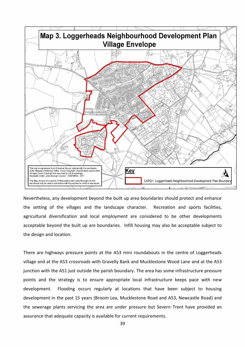
39
Nevertheless, any development beyond the built up area boundaries should protect and enhance
the setting of the villages and the landscape character. Recreation and sports facilities,
agricultural diversification and local employment are considered to be other developments
acceptable beyond the built up are boundaries. Infill housing may also be acceptable subject to
the design and location.
There are highways pressure points at the A53 mini roundabouts in the centre of Loggerheads
village and at the A53 crossroads with Gravelly Bank and Mucklestone Wood Lane and at the A53
junction with the A51 just outside the parish boundary. The area has some infrastructure pressure
points and the strategy is to ensure appropriate local infrastructure keeps pace with new
development. Flooding occurs regularly at locations that have been subject to housing
development in the past 15 years (Broom Lea, Mucklestone Road and A53, Newcastle Road) and
the sewerage plants servicing the area are under pressure but Severn Trent have provided an
assurance that adequate capacity is available for current requirements.

40
Resident’s views recorded as part of the Neighbourhood Plan research highlight the principle of
housing development being supported by an enhancement in community, and recreational
facilities and improvements in infrastructure. This could be assisted by Section 106 agreements
and any future Community Infrastructure Levy (CIL). At this time Newcastle under Lyme Borough
Council does not have a CIL policy.
6.1.3 Policies
Interpretation:
This policy ensures that new development is focused in the settlement boundaries within
Loggerheads village. The village envelope of Loggerheads village defines the areas where growth
would be sustainable and acceptable, subject to compliance with other policies.
Mixed use development, or development that adds to the local mix of uses, is particularly
encouraged.
The policy does not deal with consideration of exception sites, which are covered by policies in the
Local Plan.
LNPG1: New Housing Growth
New housing development will be supported within the village envelope of
Loggerheads village as defined in this Neighbourhood Plan.
Outside of the village envelope, housing development will be supported where:
It is a replacement dwelling, or limited infill housing, or within a built frontage
of existing dwellings; and
It will reflect the character of surrounding dwellings and will not lead to
significant loss of garden space; and
It will not cause significant harm to residential amenity; or
It is a new isolated home in the countryside that meets the special
circumstances described in paragraph 55 of the Framework.

41
The scale of housing appropriate for infill is small gaps in otherwise built up frontages for one or
two properties at most.
The location of community and employment development is dealt with in later policies.

42
6.2 Housing Mix
6.2.1 Purpose
To ensure that new housing development contributes to creating a balanced mix of housing in
the area, to meet identified local needs in a sustainable manner.
6.2.2 Rationale and Evidence
Paragraph 50 of the National Planning Policy Framework seeks to:
"deliver a wide choice of high quality homes, widen opportunities for home
ownership and create sustainable, inclusive and mixed communities", and that local
planning authorities should "plan for a mix of housing based on current and future
demographic trends, market trends and the needs of different groups in the
community", and "identify the size, type and tenure and range of housing that is
required".
Documented local evidence, listed below, indicates that there is currently a mismatch between
local housing needs – which are very specific, and include the need to cater for an ageing
population, and the needs of young people and families – and that which is currently being
provided, or is in the pipeline, which is in the main larger homes.
the Strategic Housing Market Assessment 2015 Stoke-on-Trent City Council and Newcastle-
under-Lyme
the Strategic Housing Market Assessment Update Stoke-on-Trent City Council and
Newcastle-under-Lyme Borough Council June 2017
the Parish of Loggerheads Housing Needs Assessment 2016 and update July 2017
Policy LNPG2 is intended to ensure a diverse housing mix that addresses local housing needs as
identified in the Parish of Loggerheads Housing Needs Assessment. This identifies a shortage of
smaller homes for younger people and downsizing. In addition, there is a shortage of properties to
allow independent living opportunities for the elderly, for example bungalows. The policy will be
used to influence those outline applications that have not yet been submitted as full applications,

43
extant planning permissions already meet the local housing need according to the Housing Needs
Assessment for Loggerheads.
Around a third of all new housing needs to comprise smaller homes (one and two bedrooms) to
address identified needs. In particular there is a need to create housing accessible for younger
people and older people. This is reinforced by the local demographics, as shown in the Parish of
Loggerheads Housing Needs Assessment, which indicates that the population is rapidly ageing.
It would be unreasonable to apply such a detailed mix to smaller sites i.e. those fewer than 10
dwellings, as this would give rise to viability issues.
Loggerheads is a popular village in which to live. There has been a significant increase in the
number of residents over 60 (53% between 2001 and 2011). As a result Loggerheads has a
disproportionate number of older residents (30% over 60) compared with the English average of
16%. This disparity is likely to become more marked in coming years, with 17.7% of residents in
the 55 – 64 age bracket, compared with 12% in England. This threatens the vitality of the
community and places extra and different demands on local health, transport and housing.
Loggerheads housing stock is dominated by detached owner-occupied properties. 67% of
Loggerheads houses are detached (22% in England) and 81% owner‐occupied (64% in England).
House prices in “the rural south” are below the national average but above the average for
Newcastle Borough.
National £320,000
Newcastle £145,800
Rural south £250,000
Only 30.5% of houses are placed in Council Tax bands A to C as against 65% in England. This points
to a relative shortage of small homes that can be afforded by people on relatively low incomes.
This is confirmed by the following:
Proportion of terraced housing & flats, Loggerheads 5.5%, England 47%
Social rented housing Loggerheads 6.1%, England 18%

44
Loggerheads needs more young people and families for the community to retain its age balance
but the current shortage of affordable housing and public transport to centres of employment
denies young people and families the opportunity to live in the village where they grew up. The
area needs smaller homes for older people wishing to downsize and remain in the area and for
young singles and couples. This is evidenced by the Housing Needs Assessment.
With 315 existing permissions in Loggerheads parish, at June 2017, of which the majority (283) are
in Loggerheads village and Ashley/Ashley Heath (31); only 1 is in another part of the parish,
Knighton; Loggerheads has met the housing needs for 19.6 years with the majority of permissions
located outside the current village envelope. The Housing Needs Assessment shows that current
supply and potential supply from planning permissions is not matching local need. Loggerheads
has 2.2 times the number of detached homes compared to the English average and an under-
representation of semi-detached homes (26.5% compared to 30.7%) Only 6.8% of homes are
terraced or flats compared to the English average of 41.2%. This reduces the supply of less
expensive homes in a village where, in local terms, housing is relatively expensive.
In 2012, a survey on affordable housing in Loggerheads undertaken jointly by Newcastle under
Lyme Borough Council and Aspire Housing, the main social housing provider in the area, confirmed
that there was a need for affordable housing and that the number of social houses within
Loggerheads is extremely low and limited. The greatest need was for two bedroom homes (43%)
and three bedrooms (26%). A significant number of single persons responding wanted to meet
their housing need through private ownership, whereas a significant number of older households
(57%) wanted to meet their need through the rented tenure. The Neighbourhood Plan supports
the development of affordable housing in Loggerheads for rent, shared ownership and for sale to
local people.
Of the 315 permissions only 76 would be for “affordable” homes, but of these only 11 were for 2
bedroom homes. The significant majority are for 4 bedroom homes, which do not provide for the
needs of single person households (age 60 years and above and for young people).

45
6.2.3 Policies
Interpretation:
Evidence of local need suggests an under-supply of smaller housing, indicating a need for a high
proportion of smaller properties in new development; however, viability must also be considered.
Therefore, to comply with the policy, at least a third of new homes must comprise smaller
(one/two bedroom) accommodation, unless it can be demonstrated by developers that there is
not a need for this level of provision. This should include starter homes to meet the needs of first
time buyers, small families and local workers, including agricultural workers. A proportion of this
should be suitable for the elderly, for example single floor.
Developers should base the mix on evidence of local need and this should be demonstrated as
part of the planning application.
The policy does not seek to modify the requirements of the Local Plan in terms of proportion of
affordable housing. This is not an additional requirement on top of affordable requirements under
the Borough Council’s CSS Policy CSP6: Affordable Housing. However, it does make clear that
affordable housing should be provided as part of the development, rather than developers making
financial contributions towards affordable housing elsewhere.
Development providing in excess of these requirements for smaller and elderly accommodation
will be welcomed in particular.
The Parish Council would encourage compliance with Lifetimes Homes standard.
LNPG2: Housing Mix
To be supported, proposals for ten or more houses must include a mix of types of
accommodation to meet requirements identified in the latest assessment of local housing
needs including accommodation suitable for first time buyers and the elderly. At least a
third of new homes, unless it can be demonstrated there is not a need for this level of
provision must comprise a combination of:
One or two bedroomed properties and
One or two bedroomed properties suitable to provide independent living for the
elderly
Affordable housing must be provided as an integral part of each development, rather than
being provided remotely through financial contribution.

46
6.3 Place & Heritage
6.3.1 Purpose
To ensure that new development is safe, inclusive, functional and sustainable. To preserve and
enhance local heritage and green infrastructure.
6.3.2 Rationale and Evidence
Paragraph 56 of the NPPF states:
"Good design is a key aspect of sustainable development, is indivisible from good
planning, and should contribute positively to making places better for people".
Paragraph 58 refers to different design issues, including the need for developments to be well
functioning, have a strong sense of place, have an appropriate mix of uses, respond to local
character whilst not discouraging innovation, create safe and accessible environments, and have
good architecture and landscaping.
Chapter 12 identifies various aspects of the historic environment, including archaeology, as a
material consideration within the planning system
NPPF themes for achieving sustainable development include:
promoting sustainable transport
delivering a wide choice of high quality homes
requiring good design
promoting healthy communities
meeting the challenge of climate change
conserving and enhancing the natural environment
conserving and enhancing the historic environment
protecting all designated heritage assets
Policies LNPP1, LNPP2, and LNPP3 have been formulated to address these themes.
Quality of environment is a key factor in an area’s ability to attract economic growth and in
creating quality of life for residents. Creating high-quality and well-functioning places is therefore
an important element in attracting population and investment to the area. Ensuring that new

47
development is well-designed, inclusive and sustainable is not just about environmental
protection, but also about consideration of social and economic sustainability.
Heritage not only has cultural value and adds to the distinctive character of the area, but is also in
productive use for the most part, e.g. housing, business, enterprise space, recreational facilities. It
is essential that heritage adapts to remain fit for purpose and realises its economic potential,
whilst also being careful to preserve its special architectural, archaeological or historic interest and
the character of the area. The loss of heritage assets is not just a cultural loss, but also an
economic loss. The National Planning Policy Framework also seeks the protection of the character
and setting of listed buildings and Conservation Areas. Heritage assets are located across the area.
Listed buildings and scheduled monuments and conservation areas are designated and protected
assets (as are registered battlefields) and are all covered by the term designated heritage
assets. This is also the terminology used in the NPPF.
Recorded monuments such as farmsteads are non-designated heritage assets. This would also
cover archaeological assets such as earthworks and more general concepts such as village
characters and views. The heritage book includes all of these types of asset except the general
concepts but these are dealt with elsewhere in the plan.
Through evaluation, there is a good understanding of the distinctive character of the villages in the
parish, and the surrounding landscape. Evidence of this can be seen in the Character Area
Assessment (available at www.loggerheadsparishcouncil.co.uk).
The best thing about living in the Parish was considered to be the essentially rural nature of the
area with nice scenery and a quiet, peaceful atmosphere, which the Neighbourhood Plan Group
have termed “the ruralness” of Loggerheads. The area contains a range of designated and non-
designated heritage assets, as set out in section 3.3.2. The strategy is to protect sensitive areas
from the adverse impacts of inappropriate new development and to ensure new development is
of a design and quality so as to contribute to heritage of the future. To protect the wealth of
heritage in the parish the plan will allow historic buildings and sites that are at risk to take on new
uses.
48
The value and sensitivity of the landscape, the setting of the villages and the distinctive heritage
assets have been taken into account in assessing the suitability of development opportunities.
The maps in the Character Study on the parish council website
(www.loggerheadsparishcouncil.co.uk) show the key areas that will be conserved by the policies in
this plan. Map 4 shows the location of scheduled monuments, conservation areas and SSSIs in
relation to the village envelope. (Note the old village envelope of Ashley is included).
The policies are consistent with the adopted Newcastle-Under-Lyme and Stoke-on-Trent Core
Spatial Strategy 2006-2026, Newcastle-under-Lyme Local Plan, 2011 – schedule of saved policies
beyond 2007, the Emerging Newcastle-under-Lyme and Stoke-on-Trent Joint Local Plan, 2013-
2039, Newcastle-under-Lyme Green Infrastructure Strategy (2017) and Newcastle-under-Lyme
Open Space Strategy (2017).

49

50
LNPP1: Urban Design and Environment
To be supported, new development must demonstrate high standards of design. This includes:
1. Designing buildings, streets, spaces, landscaping and planting to create
attractive, safe and well-functioning environments, with a sense of place.
2. Comprising site-specific design solutions to complement, but not
necessarily imitate, the surrounding context.
3. Complementing the established character of the surrounding context in
terms of scale, density, massing, height and degree of set-back from
streets and spaces.
4. Providing active frontages to overlook public streets and spaces from
inhabited rooms.
5. Creating attractive, safe and convenient environments for pedestrians.
6. Responding positively to local topography.
7. Retaining trees and hedgerows (unless it is demonstrated the need for,
and benefits of, development in that location clearly outweigh the loss or
they are judged to be poor specimens or species not appropriate to the
area) and providing high quality planting and landscape design.
8. Creating a strong green infrastructure buffer on the interface between
urban and rural to buffer surrounding landscape from development
9. Providing a mix of overlooked parking provision, as an integral part of
layout, so that parking does not dominate streets and space.
10. Designing open spaces to be safe, attractive and functional as an integral
part of layout.
11. Clearly distinguishing between public and private spaces, avoiding placing
rear garden fences adjacent to street frontages.
12. Provide convenient, well-screened storage space for bins and recycling.
13. Include high quality materials, to complement those used in the
surrounding context.
14. Designing residential garages so that they do not obscure or dominate
frontages and are in or behind the building line.
15. Providing shop-fronts to commercial and retail properties, reflecting the
character of the area.
16. Ensure fencing and lockable gating is used to deny unauthorised access to
the rear of properties, positioned as close to the front of the building line
as possible.
6.3.3. Policies

51
Interpretation: This policy applies to residential, commercial, industrial and other forms of development. It seeks
to promote social and environmental sustainability by addressing public safety, character,
amenity, protection of landscape, pedestrian convenience and local distinctiveness.
The policy applies to all scales of development. Obviously, for very small-scale development,
requirements referring to layout or the wider public realm would not be applicable. A
proportionate approach will be taken in applying the policy, depending on the scale of
development.
It is essential that the design process is based on an analysis of the site and context and that the
design solution responds to the key characteristics of that analysis.
Active frontages means development elevations containing windows and doors in habitable
rooms, so that adjacent streets and spaces are overlooked.
Parking should comprise a mix of garage space, driveway spaces, on-street and other kinds of
provision. Providing a mix of approaches helps to ensure that development and the public realm is
not dominated by parking.
Shop windows should be conditioned so that they are not obscured by pictures or advertising.
The policy avoids any kind of stylistic prescription, as required by the National Planning Policy
Framework. Indeed, creative and innovative design solutions are especially encouraged. These will
be the heritage of the 21st century. In particular, designs that incorporate low or zero carbon use
are strongly encouraged.

52
Interpretation:
Whilst Policy LNPP1 deals with general principles of good urban design and context, Policy LNPP2
focuses on the different characteristics of local settlements. The policy highlights particular
contextual characteristics that must be taken into account in different settlements.
It is especially important in historic areas that new development comprises site-specific designs,
based on an analysis and understanding of the historic context.
LNPP2: Local Character & Heritage
New development must complement and reinforce the local character of the area and non-
designated heritage, including conserving buildings and their setting and comprising high-
quality, site-specific design. A balanced judgement will be required having regard to the scale
of any harm or loss to a non-designated heritage asset and the significance of the heritage
asset. Potential non-designated heritage of particular sensitivity is listed in the Loggerheads
Heritage book. This includes taking account of the following requirements for the main
Character Areas (see map 5).
Loggerheads Village: opportunities must be taken to improve legibility by creating
distinctive new townscape and buildings.
Ashley Heath: in complementing local context and character, particular attention must
be paid to:
complementing the established character, based on housing set-back from the
road, often with front boundary hedges
Preserving protected trees.
Ashley: must complement the immediate context, including:
the Radburn layout of housing off Charnes Road
Adding to the diversity of character created by a number of listed buildings.

53
This policy is not intended to require stylistic imitation. Historic environments should not be a
barrier to creative and innovative design solutions. Imitation can be harmful, in particular to
historic environments, where authenticity is important. For landmark buildings in particular,
parody or imitation can harm the setting. The policy should enable and not prevent a new heritage
of the 21st century being created.
Map 5 shows these character settings.
The requirement to complement the historic character of Loggerheads does not imply that
schemes should not have an impact or change the character or appearance of the area. The
existing historic environments are a result of change over time. Being visible does not imply harm
in all circumstances. A judgment will be taken based on the specific proposal and the
characteristics of specific heritage assets affected. Any applications that related to farmsteads
will be considered by reference to the Staffordshire Farmsteads Guidance.
Newcastle-under-Lyme Borough Council holds a Register of Locally Important Buildings and
Structures. In 2018 this contained 3 of the non-designated heritage assets for Loggerheads: War
Memorials at Waterside Cottage, Tyrley, St John the Baptist Church, Ashley and St Mary’s Church,
Hales. The Borough Council reviews this list annually and seeks nominations for additions. The
Borough Council has published criteria and a scoring system including weighted criteria relating to:
authenticity; architectural interest; historic interest; visual importance; and community value. The
Parish Council nominated 13 non-designated heritage assets identified in the Heritage Book for
inclusion in the Register in June 2018. The Borough Council reviewed the nominations and
adopted 7 in their Register. These are Ashley Methodist Church, Ashley Surgery, Loggerheads Inn,
War memorial at Hugo Meynell School, Providence Chapel, Hookgate, Knighton Village Hall, and
Skelhorn’s Anvil in St Marys Churchyard, Mucklestone. Six potential non-designated assets were
not adopted in the register, namely; Oddfellows Hall, Ashley, Ashley Memorial Hall, Former
Methodist Chapel, Hookgate, War Memorial inside Mucklestone Church, Broomhall Lodge and
Hales Club. In the future, if these and other buildings and structures are identified as important
non-designated heritage assets in the parish, a similar process would be followed to nominate
them to the Borough Council for inclusion in their Register of Locally Important Buildings and
Structures.

54
Map 5: Character Areas
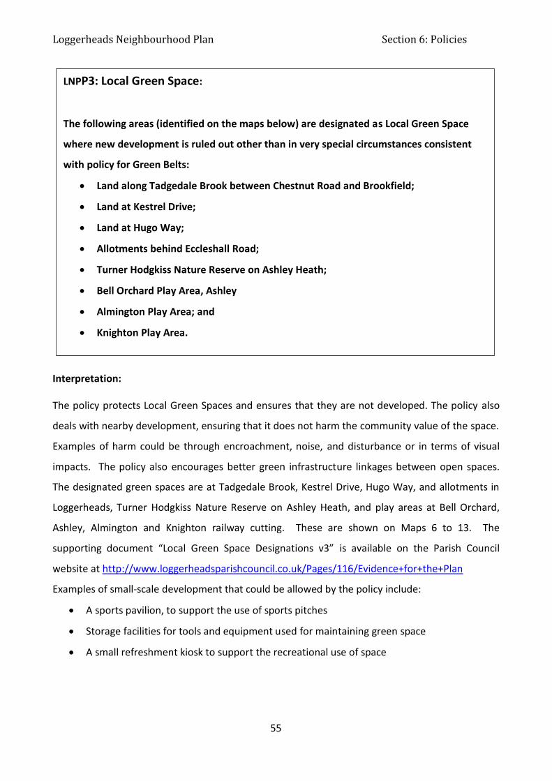
Loggerheads Neighbourhood Plan Section 6: Policies
55
Interpretation: The policy protects Local Green Spaces and ensures that they are not developed. The policy also
deals with nearby development, ensuring that it does not harm the community value of the space.
Examples of harm could be through encroachment, noise, and disturbance or in terms of visual
impacts. The policy also encourages better green infrastructure linkages between open spaces.
The designated green spaces are at Tadgedale Brook, Kestrel Drive, Hugo Way, and allotments in
Loggerheads, Turner Hodgkiss Nature Reserve on Ashley Heath, and play areas at Bell Orchard,
Ashley, Almington and Knighton railway cutting. These are shown on Maps 6 to 13. The
supporting document “Local Green Space Designations v3” is available on the Parish Council
website at http://www.loggerheadsparishcouncil.co.uk/Pages/116/Evidence+for+the+Plan
Examples of small-scale development that could be allowed by the policy include:
A sports pavilion, to support the use of sports pitches
Storage facilities for tools and equipment used for maintaining green space
A small refreshment kiosk to support the recreational use of space
LNPP3: Local Green Space:
The following areas (identified on the maps below) are designated as Local Green Space
where new development is ruled out other than in very special circumstances consistent
with policy for Green Belts:
Land along Tadgedale Brook between Chestnut Road and Brookfield;
Land at Kestrel Drive;
Land at Hugo Way;
Allotments behind Eccleshall Road;
Turner Hodgkiss Nature Reserve on Ashley Heath;
Bell Orchard Play Area, Ashley
Almington Play Area; and
Knighton Play Area.
.

Loggerheads Neighbourhood Plan Section 6: Policies
56
A summary of each site setting out its community value and how it meets NPPF Criteria and a map
to show the location is below.
Green space, along Tadgedale Brook, between Chestnut Road and Brookfield in Loggerheads
village is within walking distance of 250 houses. It is a grassed open space 84 feet wide along both
sides of the brook for walking dogs and access for residents on estate on north of brook to reach
south side for shops and school, 0.25 mile in length, with 8 points of access. Play equipment at 4
locations close to access points to Chestnut Road, Fox Hollow, Sharplands and Chartwood. Total 2
hectares. This attractive and tranquil space acts as a focal point for people living locally.
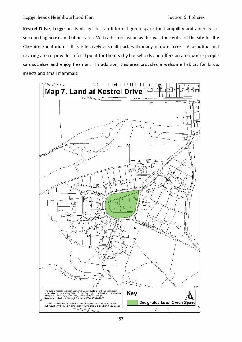
Loggerheads Neighbourhood Plan Section 6: Policies
57
Kestrel Drive, Loggerheads village, has an informal green space for tranquility and amenity for
surrounding houses of 0.4 hectares. With a historic value as this was the centre of the site for the
Cheshire Sanatorium. It is effectively a small park with many mature trees. A beautiful and
relaxing area it provides a focal point for the nearby households and offers an area where people
can socialise and enjoy fresh air. In addition, this area provides a welcome habitat for birds,
insects and small mammals.

Loggerheads Neighbourhood Plan Section 6: Policies
58
Hugo Way, Loggerheads village has a narrow strip of green space up both sides with a wide lay-by
on one side of the road and a small play area on a tarmac base at top of road with more green
space on two sides of play area. It is used for play and totals 0.3 hectares. Hugo Way play area
and surrounding green space is situated between two housing estates; this attractive and tranquil
space acts as a focal point for people living locally.

Loggerheads Neighbourhood Plan Section 6: Policies
59
Allotments in Loggerheads village off B5026 Eccleshall Road, between Hugo Meynell School on
one side, Hugo Way on two sides and behind the houses on Eccleshall Road. Registered as an
Asset of Community Value, 2 hectare site with 40 allotments all in active use and within walking
distance of all houses in Loggerheads village and Ashley Heath. Loggerheads Allotments provide
the community with a green and tranquil environment where people can socialise whist indulging
in healthy activity in the fresh air. In addition, home grown produce encourages a healthy
lifestyle. The maintenance of the allotment encourages biodiversity and enhances the local
ecosystem.
Newcastle under Lyme Borough Council Open Space Strategy (2016) supports its designation as it
identifies a shortfall in allotments in the borough.
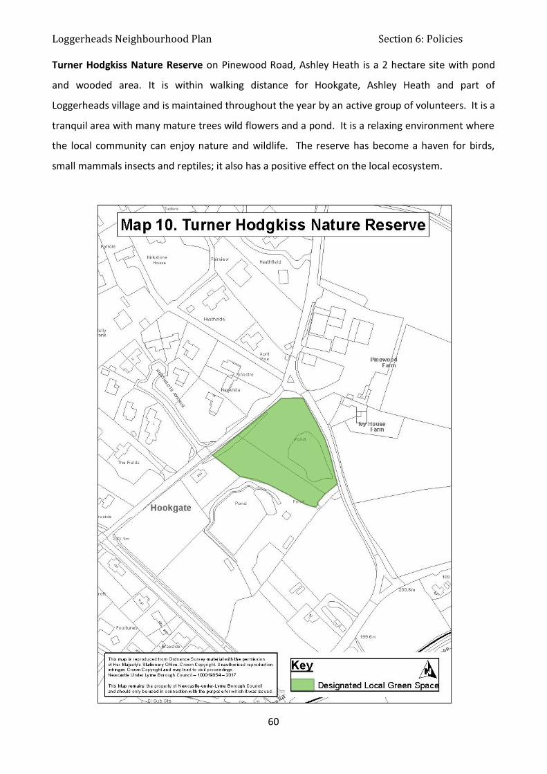
Loggerheads Neighbourhood Plan Section 6: Policies
60
Turner Hodgkiss Nature Reserve on Pinewood Road, Ashley Heath is a 2 hectare site with pond
and wooded area. It is within walking distance for Hookgate, Ashley Heath and part of
Loggerheads village and is maintained throughout the year by an active group of volunteers. It is a
tranquil area with many mature trees wild flowers and a pond. It is a relaxing environment where
the local community can enjoy nature and wildlife. The reserve has become a haven for birds,
small mammals insects and reptiles; it also has a positive effect on the local ecosystem.
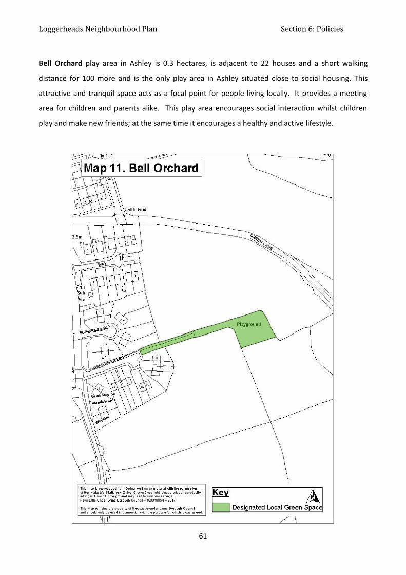
Loggerheads Neighbourhood Plan Section 6: Policies
61
Bell Orchard play area in Ashley is 0.3 hectares, is adjacent to 22 houses and a short walking
distance for 100 more and is the only play area in Ashley situated close to social housing. This
attractive and tranquil space acts as a focal point for people living locally. It provides a meeting
area for children and parents alike. This play area encourages social interaction whilst children
play and make new friends; at the same time it encourages a healthy and active lifestyle.
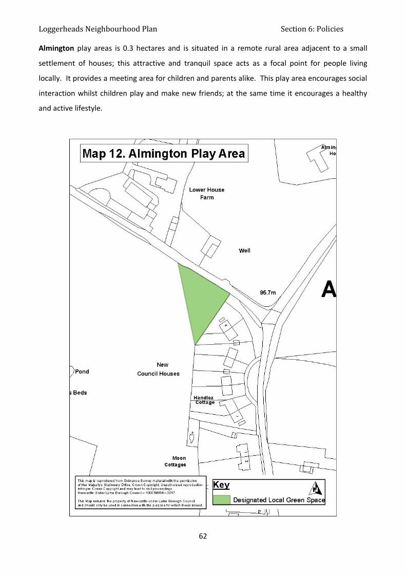
Loggerheads Neighbourhood Plan Section 6: Policies
62
Almington play areas is 0.3 hectares and is situated in a remote rural area adjacent to a small
settlement of houses; this attractive and tranquil space acts as a focal point for people living
locally. It provides a meeting area for children and parents alike. This play area encourages social
interaction whilst children play and make new friends; at the same time it encourages a healthy
and active lifestyle.

Loggerheads Neighbourhood Plan Section 6: Policies
63
Knighton play area is a short walking distance to the centre of Knighton village and the only play
area in the village. It is grassed open space situated at one end of part of a disused railway line
with play equipment for children’s play, roughly square, 0.25 hectares. This leads into a grassed
walkway along the old disused railway for 0.3 mile. This attractive and tranquil space acts as a
focal point for people living locally. It provides a meeting area for children and parents alike. This
play area encourages social interaction whilst children play and make new friends; at the same
time it encourages a healthy and active lifestyle. The tranquil walkway allows residents in
Knighton to walk away from traffic in a village with limited pedestrian pathways.

Loggerheads Neighbourhood Plan Section 6: Policies
64
6.4 Transport & Movement
6.4.1 Purpose
To encourage mixed transport provision, including more sustainable forms of transport, cycling
and walking.
6.4.2 Rationale and Evidence
Due to the peripheral location of Loggerheads, it is served by limited public transport services and
there has been a strong reliance on car-based travel. This policy seeks to ensure that there are
opportunities for using more sustainable forms of transport and walking.
Paragraph 29 of the NPPF states:
“The transport system needs to be balanced in favour of sustainable transport
modes, giving people a real choice about how they travel”.
Paragraph 34 states:
“Plans and decisions should ensure developments that generate significant movement are
located where the need to travel will be minimised and the use of sustainable transport
modes can be maximized”.
The transport situation in Loggerheads Parish is similar to many other villages in rural areas:
High car ownership and an increase in car traffic
Limited public transport to centres of employment
No cycle ways
Development brought forward through the Neighbourhood Plan will have an impact on the
transport situation of the Parish. Pathways are needed to fill the gaps in existing provision on
Mucklestone Road, Mucklestone Wood Lane and from Knighton to Woore to allow residents to
walk safely from their homes to the retail facilities and local schools in Loggerheads and Woore.
Public transport is limited and only connects Loggerheads and Ashley to Market Drayton and
Newcastle daily (Monday to Saturday, once an hour, from 8am till 6pm) and Loggerheads to
Stafford on a Thursday and Saturday only, once a day. (This service is due to cease in March 2018).

Loggerheads Neighbourhood Plan Section 6: Policies
65
There is no longer any bus service to Knighton and the other villages in the area have never had a
service. It is impossible to commute by public transport from Loggerheads to any locality for work
that starts at 8am. Any improvement in service would provide a vital lifeline between
communities, especially for the young and elderly and also help to boost the rural economy as
people would be able to access local shops and services, instead of commuting into the urban
conurbations. It would also help to reduce the load on the infrastructure within the urban areas
and improve opportunities in rural areas.
There are transport infrastructure pressure points in the parish at:
the A53 mini roundabouts in the centre of Loggerheads Village (a hot spot for minor
collisions and near misses, not recordable statistics but well known by local residents, only
4 recorded slight collisions in last 5 years)
the A53 crossroads with Gravelly Bank and Mucklestone Wood Lane (the scene of 2 fatal
and 3 serious collisions in the last 5 years)
The A53 junction with the A51, just outside the parish boundary (congestion at peak times,
supported by traffic flow assessment). A traffic assessment for the A51/53 junction is on
Parish Council website www.loggerheadsparishcouncil.co.uk

Loggerheads Neighbourhood Plan Section 6: Policies
66
LNPT1: Sustainable Transport
To be supported new development comprising new homes, employment units or community
facilities must, subject to viability considerations, demonstrate a balanced and sustainable
approach to transport, including:
Providing for different modes of transport, including walking and cycling including
incorporating secure, covered storage space for cycles
Providing electric car charging points
Ensuring there is no significant negative impact on road safety and severe traffic
congestion
Providing safe and suitable access for both vehicles and pedestrians
Incorporating well-connected and permeable pedestrian networks; where not
already in place, footways (pavements) are provided to link the site to the existing
footway network
6.4.3 Policies
Interpretation: The policy requires new development to cater for walking, cycling and cars, including electric
vehicles. The policy applies to all sizes of development; for example, even a single dwelling may
incorporate storage space for a cycle. A proportionate approach will be required in applying the
policy.
By accommodating growth, the Neighbourhood Plan may help to make sure public transport
services remain viable.
There may be opportunities for improving transport infrastructure using Section 106 contributions
or any future Community Infrastructure Levy.
Priorities for improving transport are:

Loggerheads Neighbourhood Plan Section 6: Policies
67
Highways improvements at the A53 mini roundabouts in the centre of Loggerheads village,
the A53 crossroads with Gravelly Bank and Mucklestone Wood Lane and the A53 junction
with the A51 just outside the parish boundary
Pathways are needed to fill the gaps in existing provision on Mucklestone Road,
Mucklestone Wood Lane and from Knighton to Woore

Loggerheads Neighbourhood Plan Section 6: Policies
68
6.5 Sport, Health & Community Facilities
6.5.1 Purpose
To enable and encourage a balanced mix of uses, including a range of local community and sport
facilities accessible by walking, cycling or short car journeys.
6.5.2 Rationale and Evidence
Given the location of the parish in the urban fringe and remoteness from urban areas, it is
necessary to create a balanced mix of uses, including local community and sport facilities. This is
important in terms of quality of life, health and well-being and the creation of a more sustainable
settlement.
The National Planning Policy Framework encourages planning policies to:
Aim to achieve places which promote opportunities for meetings between members of
the community who might not otherwise come into contact with each other and plan
positively for the provision and use of community facilities (such as meeting places,
sports venues, cultural buildings and places of worship) and other local services to
enhance the sustainability of communities and residential environments. Policies
should guard against the unnecessary loss of valued facilities and services, particularly
where this would reduce the community’s ability to meet its day-to-day needs.
National Planning Policy Framework Para 73: Access to high quality open spaces and
opportunities for sport and recreation can make an important contribution to the
health and well-being of communities. Planning policies should be based on robust and
up-to-date assessments of the needs for open space, sports and recreation facilities
and opportunities for new provision. The assessments should identify specific needs
and quantitative or qualitative deficits or surpluses of open space, sports and
recreational facilities in the local area. Information gained from the assessments
should be used to determine what open space, sports and recreational provision is
required.
National Planning Policy Framework refers to Open Space Policy guidance; this policy is expressed
by Fields In Trust, and adopted by Sport England. They refer to the 6 Acre Standard, which says
there should be 6 acres of open space per 1000 people. This is then further refined to say, that
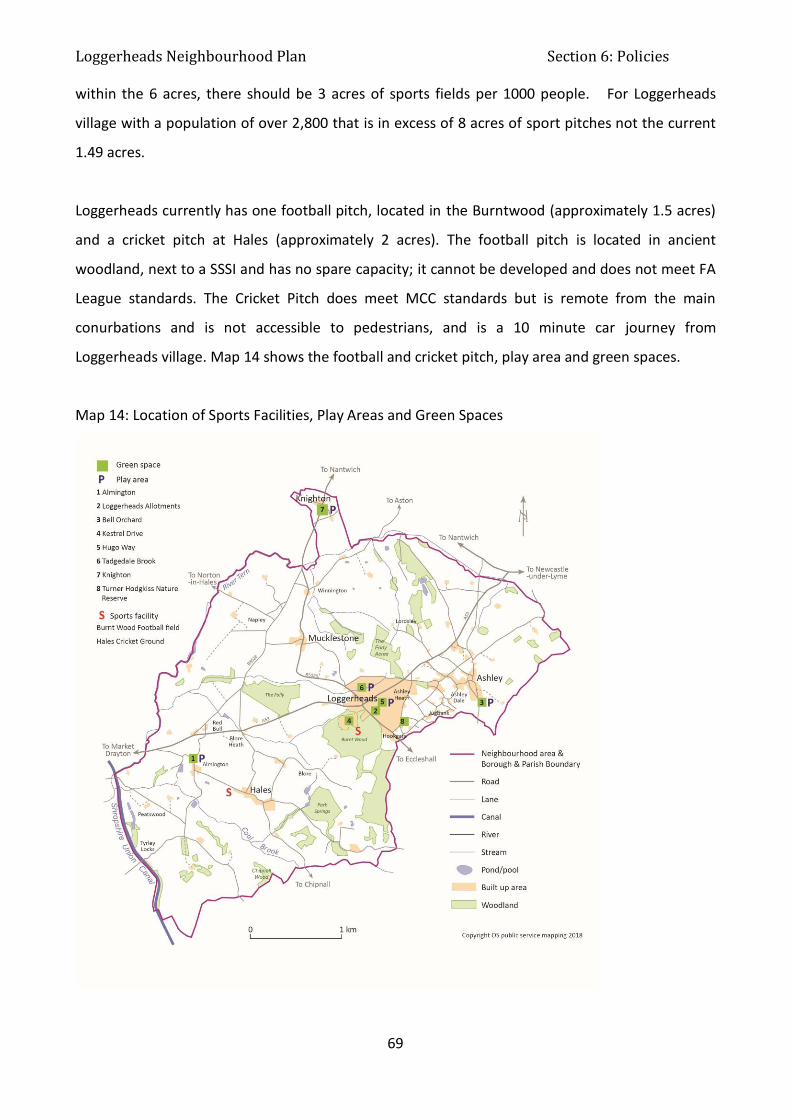
Loggerheads Neighbourhood Plan Section 6: Policies
69
within the 6 acres, there should be 3 acres of sports fields per 1000 people. For Loggerheads
village with a population of over 2,800 that is in excess of 8 acres of sport pitches not the current
1.49 acres.
Loggerheads currently has one football pitch, located in the Burntwood (approximately 1.5 acres)
and a cricket pitch at Hales (approximately 2 acres). The football pitch is located in ancient
woodland, next to a SSSI and has no spare capacity; it cannot be developed and does not meet FA
League standards. The Cricket Pitch does meet MCC standards but is remote from the main
conurbations and is not accessible to pedestrians, and is a 10 minute car journey from
Loggerheads village. Map 14 shows the football and cricket pitch, play area and green spaces.
Map 14: Location of Sports Facilities, Play Areas and Green Spaces

Loggerheads Neighbourhood Plan Section 6: Policies
70
There is no other recreational space apart from a number of small play areas (Local Areas for Play
(LAP) and Local Equipped Areas for Play (LEAP) for children under 11, located in Ashley, Knighton,
Almington and Loggerheads. Loggerheads does not have a Neighbourhood Equipped Area for Play
(NEAP) or a Multi-Use Games Area (MUGA).
The nearest sporting and leisure facilities are located in Market Drayton, 5 miles from
Loggerheads, with only 1 bus per hour between 8am and 6pm Monday to Friday.
Newcastle under Lyme Borough Council has a Playing Pitch Strategy, (Newcastle under Lyme
Playing Pitch Strategy 2015). The NULBC Playing Pitch Strategy notes for the rural area that there
is “No demand for additional football pitches” and a “growing demand for the use of central
venues in the area for mini and youth football”. There is “high demand area for cricket in the Area
resulting in a shortfall of six pitches, predominately due to overplay and latent demand to be met
by new wickets (not pitches) on existing club sites and opening up school sites.” The cricket pitch
at Hales is not included in the list of available pitches. The football pitch at the Burntwood in
Loggerheads village is assessed in the strategy as “standard quality adult pitch with minimal spare
capacity. Pitch is minimum size and is not serviced by changing rooms”. The recommended action
in the strategy is: “Spare capacity should be retained to help protect/improve quality. Support the
Club in its aspirations to develop the site and ensure long term security is agreed and put into
place”.
The pitch actually measures 93 yards by 60 yards. The FA dictates that a pitch must be between
100 and 120 yards long, for this reason the local team has to play home matches at Eccleshall
Football Club. In addition, parents are reticent to allow children to play on the pitch as it is
remote, in local woods. Staffordshire Police responded to the draft Neighbourhood Plan
consultation to say that “Facilities located in poorly overlooked, enclosed or out of the way places
are ill-advised. As demonstrated, there can be a reluctance to allow children to use them resulting
in under-use. In some circumstances they can attract anti-social behaviour and other unwanted
attention that can have implications for child safety.”
Looking to the future and anticipating population growth land needs to be set aside that is fit for
the Government’s new “Sporting Future” strategy, along with open space and sports facilities.

Loggerheads Neighbourhood Plan Section 6: Policies
71
There are four “village halls” in the parish, in Ashley, Knighton and Hales, shown on Map 15. There
is no dedicated facility in Loggerheads village where over 60% of the population lives. Local
groups such as Scouts and Brownies use the school hall at the Hugo Meynell School in
Loggerheads. The Community Fire Station in Loggerheads, opened in April 2015, is also available
for use for meetings and events such as coffee mornings, with a capacity of 40 people.
Map 15: Location of Village Halls
In 2016 Loggerheads Parish Council commissioned Urban Vision to conduct a Feasibility Study into
the viability of creating a Community Hall and sports facility. As part of this study a Sporting

Loggerheads Neighbourhood Plan Section 6: Policies
72
Needs assessment was carried out using Fields in Trust Benchmark guidelines. The study
considered the needs of the whole Parish; the results of this assessment follow:
Need and Demand
In order to determine the level of need for the proposed facility, the settlement of Loggerheads
has been assessed against Fields in Trust benchmarking guidelines, as shown in table 14 below:
Table 14: Fields in Trust recommended benchmark guidelines for formal outdoor space
From “Guidance for Outdoor Sport and Play: Beyond the Six Acre Standard” (Fields in Trust)
The guidelines have been applied to the projected population of Loggerheads Parish by 2033 (the
end of the Neighbourhood Plan period). This has been calculated as 5,512, as shown in Table 15.
Table 15: Projected Population for Loggerheads at 2033
Item
No.
Current Population (as per 2011 Census)
4,480
Extant Residential Planning Permissions Tadgedale Quarry Appeal Proposed Site Allocations
Total New Homes Pipeline=
182 128 120
430
Increase in population (430 x 2.4* = 1,032) *Average UK household size
1,032
Loggerheads population at 2033 5,512

Loggerheads Neighbourhood Plan Section 6: Policies
73
This figure could increase depending on the final development option for the residential element
of the Market Drayton Road site.
Using the projected 2033 population, and applying the Fields in Trust benchmarking guidelines in
terms of quantity, the calculation in Table 16 provides the quantity benchmark for the
Loggerheads settlement moving forward.
Table 16: Required Quantity of sports and play acreage for Loggerheads for 2033
Typology
Required Quantity Guideline
Playing Pitches
6.61ha (16.33 acres)
All Outdoor Sports
8.82ha (21.79 acres)
Equipped/Designated Play Areas
1.38ha (3.41 acres)
Other Outdoor Provision
1.65ha (4.08 acres)
The feasibility study concentrated on the provision of sports facilities with a community facility
that includes medical health care on land at Market Drayton Road. The study highlights the very
significant shortcomings in sporting provision within the Parish. The site at Market Drayton Road is
owned by Newcastle under Lyme Borough Council and subject to a planning application for
housing leaving insufficient capacity for the sports facilities required. The site being considered
has been extended to include the adjacent field to secure the acreage needed for a community
facility and sports provision. Funding opportunities are being considered.
From the residents’ survey it was strongly felt that if further housing development were to take
place it must be conditional upon other improvements. Most important were thought to be the
local infrastructure and roads (70%), followed by health facilities (65%) and bus services (60%) and
55% wanted the inclusion of community facilities.
The following three policies are designed to enable new community and sports facilities and to
protect existing sports pitches.
Loggerheads Neighbourhood Plan Section 6: Policies
74
Policy LNPS2 allocates sites on the edge of Loggerheads village for community and sports purposes
(Sites LV1 and LV2 – see Maps 16 & 17). The choice of these sites is based on various factors:
Loggerheads village is expected to accommodate housing development that will increase
the number of houses in the settlement by roughly a third (from around 1,200 to 1,600
houses). This necessitates the provision of additional community facilities.
Loggerheads village is the main settlement in the parish and the most sustainable location
for significant new community facilities.
Feasibility and needs assessment has also indicated that new sports facilities are needed
and would be viable.
The sites are outside of the Loggerheads village settlement boundary, but immediately
adjacent to it.
The sites would allow pedestrian access to all parts of Loggerheads village.
Site LV1 is immediately adjacent to the planned built area, and close to the Community Fire
Station, so is a logical and sustainable location for a new community health and sports
complex.
Site LV2 is adjacent to LV1 and will form the transition between the built area and the
surrounding countryside, so is suitable for sports pitches.
Site LV1 may not have the capacity to deliver the full scope of the project, but is the
nearest to meeting locational and capacity requirements.
The sites are close to an existing, unsatisfactory football pitch (Burntwood has poor access
and safety issues). The allocation of site LV2 is intended to provide the village with a better
facility.
Allocating two adjacent sites provides the opportunity for the two to be linked,
operationally, if required.
Site LV1 is on the boundary of a permitted application for housing with appropriate
transport and environment assessments which would apply to this site.
There is no other site available of this size in the village.
It is acknowledged that this site will have impacts on landscape character, visual impacts,
environmental, traffic and access residential amenity light pollution and is in proximity to wooded
areas. These would all be considered in detail when the project progresses.

Loggerheads Neighbourhood Plan Section 6: Policies
75
6.5.3 Policies
Interpretation
This policy refers to community infrastructure such as meeting and activity space, medical facilities
and access to open space, and highways infrastructure, including footways. The policy seeks to
ensure that new development does not exacerbate existing infrastructure problems.
There may be opportunities for financial contributions made under Section 106 to be used to
support new community infrastructure. In future, if Newcastle-Under-Lyme Borough Council puts
in place a Community Infrastructure Levy, there may be opportunities for some local
infrastructure requirements to be funded by this.
The priorities for community infrastructure would be:
A new Community and sports facility for Loggerheads Village to support sports and
community activities, medical requirements and physical activity.
Transport infrastructure requirements are dealt with by policy LNPT1.
LNPS1: Community Infrastructure
To be supported new development in excess of 10 dwellings must demonstrate that existing
community infrastructure (meeting and activity space, medical facilities, open space, highway
infrastructure including footways) is adequate to accommodate the new development, or
subject to viability considerations provide or support new community infrastructure where
necessary.

Loggerheads Neighbourhood Plan Section 6: Policies
76
Interpretation
This policy enables the development of two adjacent sites fronting Market Drayton Road. Sites
LV1 and LV2 are required for community and sports facilities and are reserved for these uses. The
sites are outside of the settlement boundary. The settlement boundary marks the extent of
housing development. Housing must not encroach onto these allocated sites.
The development of the sites should create a suitable transition between the built area of
Loggerheads and the surrounding rural area. This should inform the design of development, which
is subject to the design policies elsewhere in this plan.
LNPS2: Site Allocation for Multi-Sport and Community Facility and Sports
Pitch
Sites LV1 and LV2 fronting Market Drayton Road in Loggerheads Village (See Maps 16 &
17) are allocated for community sports and recreational uses, subject to the following:
Site LV1 is allocated for built development for a mixed use community and sports
facility, which may include uses falling within planning Use Classes D1 and D2,
together with ancillary uses, including a cafe.
Site LV2 is allocated for sports pitches, where the open character of the site is
maintained. Limited built development may be considered for approval
immediately adjacent to Site LV1, where it is directly related to the primary use as
sports pitches and where it would not compromise the open character of the site.
The sites will be protected for community and sports purposes.
The impact on residential and visual amenity, highway safety and on features of the
natural environment adjacent to the sites, are acceptable.
The sites will incorporate sustainable / natural drainage systems.

Loggerheads Neighbourhood Plan Section 6: Policies
77
Site LV1 could accommodate a multi-sport, health and community building. Suitable uses for Site
LV1 include indoor sports, performance, health and recreational uses, as part of a sustainable and
viable local facility. Flexible, multi-purpose space would be particularly welcomed.
The site allocation for Site LV2 is intended to provide sports pitches. The policy would allow a
small building, such as storage and changing facilities, adjacent to Site LV1. This could be a
separate building or a slight encroachment of a building on Site LV1 (which could incorporate
facilities to support the sports pitch). However, it is essential that the primarily open character of
Site LV2 be maintained, to prevent urban sprawl into the countryside.

Loggerheads Neighbourhood Plan Section 6: Policies
78
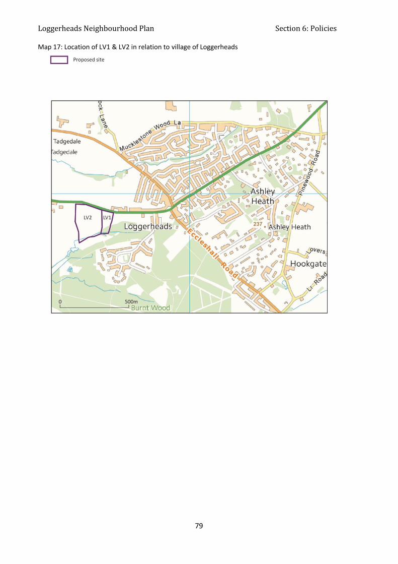
Loggerheads Neighbourhood Plan Section 6: Policies
79
Map 17: Location of LV1 & LV2 in relation to village of Loggerheads
Loggerheads Neighbourhood Plan Section 6: Policies
80
Interpretation:
The policy seeks to prevent the loss of existing sports pitches, where there is a continuing local
need. However, it allows flexibility to move such facilities to other sustainable locations.
Inclusion of any sports pitch, or any other sports or community facilities, on the register of
community assets will be a material consideration, as set out in the NPPG.
LNPS3: Sports Pitches
Planning permission for development on existing open space and sports pitches will be
supported only where it can be demonstrated that the facility is no longer required to meet
local need or where an equivalent similar or better facility is provided in a sustainable
location elsewhere in the Loggerheads area or the development is for alternative sports and
recreational provision, the needs for which clearly outweigh the loss.
Existing pitches subject to this policy are:
The football field at the Burntwood
The cricket pitch at Hales
Loggerheads Neighbourhood Plan Section 6: Policies
81
6.6 Economy
6.6.1 Purpose
To create a balanced mix of uses, including employment opportunities, to create more
sustainable live/work patterns.
6.6.2 Rationale and Evidence
New employment is required to create a balanced mix of uses locally, including work
opportunities. For rural settlements to remain viable and sustainable, it is essential that local
employment be allowed to grow. The intention is to encourage and enable more sustainable
live/work patterns.
The most recently available census shows that in 2011, 66.7% of Loggerheads residents were
economically active compared to 69.9% in England. 52% of Loggerheads economically active
residents were working in the sectors shown in Table 8 above, many outside the Parish. Only 4%
work in agriculture.
Most local employment is to be found in the village centre shops and services; community services
such as schools and the doctors’ surgery as well as those working from home.
21% travel less than 10km to work compared to the Newcastle under Lyme average of 60%. Over
double the Newcastle average travel up to 30km to work.
Following national trends we have experienced a growth in self-employment and home
businesses. Double the number of people work from home (14%) compared to the national
average (8.7%).
Fast broadband is necessary to enable business and home working. Fast broadband is also
important to quality of life and inclusivity. The introduction of Superfast Broadband in 2016 to
parts of the area is helping some of these businesses and will hopefully give an opportunity for
new enterprises to develop and grow. Broadband and mobile phone coverage is poor in some
parts, which could impact on the above average number of businesses run from residents’ homes.

Loggerheads Neighbourhood Plan Section 6: Policies
82
Broadband speed was usually in the range of 4-15 megabits per second (the higher the speed the
better). There is a commitment to extend Superfast Broadband to more areas by 2018 but an
acceptance that some parts of the rural area are not subject to any plan at this time to provide
access. (See map 18).
Access to Superfast Broadband had the highest level of criticism for service provision in the area,
66% regarding it as inadequate; that it was slow or occasionally “dropped out” or that there simply
was no Superfast Broadband. Criticism was least in Ashley (50% inadequate), which perhaps
suggests that the on-going works are having some impact. Those residents who also run
businesses (69 people) were a sub group more critical than the average, 78% regarding the service
as inadequate.
The final question in the business survey asked whether there was anything that could be
provided within the Parish which would help their business to develop over the next ten years.
The response was given predominantly by those whose business is currently based within the
Parish, either at home or in premises. The overwhelming requirements were for better Broadband
speeds (88%) and improved mobile signals (88%).
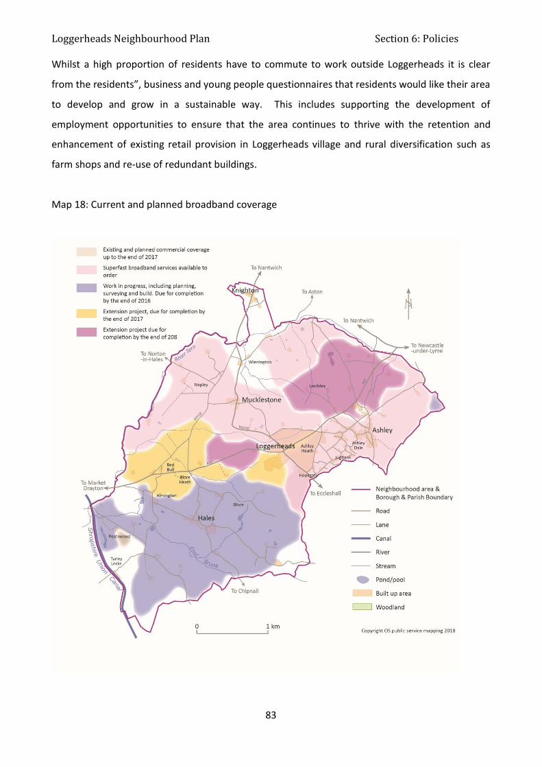
Loggerheads Neighbourhood Plan Section 6: Policies
83
Whilst a high proportion of residents have to commute to work outside Loggerheads it is clear
from the residents”, business and young people questionnaires that residents would like their area
to develop and grow in a sustainable way. This includes supporting the development of
employment opportunities to ensure that the area continues to thrive with the retention and
enhancement of existing retail provision in Loggerheads village and rural diversification such as
farm shops and re-use of redundant buildings.
Map 18: Current and planned broadband coverage

Loggerheads Neighbourhood Plan Section 6: Policies
84
6.6.3 Policies
Interpretation:
This is an enabling policy, for B1 development to support economic development, create local job
opportunities and to encourage more sustainable live/work patterns. B2 and B8 development is
enabled in certain locations, away from residential areas. Such applications will require careful
consideration in terms of amenity, traffic and environmental impact.
Consideration of impacts would include noise, disturbance, traffic movement, visual impacts, dust,
vibrations and other impacts.
LNPE1: Employment
New development or change of use to create enterprise and employment space (Use Class
B1) will be supported, providing it has no significant adverse impact on residential amenity
or on the local environment and open character of the rural environment.
Suitable locations for B1 employment development are:
within existing employment sites
in the Mucklestone Nurseries & Business Centre
agricultural buildings, to support diversification
on existing brownfield sites
within the Loggerheads village envelope
Within Loggerheads village envelope development comprising new or expanded B2 and B8
uses will be supported on existing industrial or brownfield sites, where there would be no
adverse impact on residential or visual amenity and the open character of the rural
environment.
Loggerheads Neighbourhood Plan Section 6: Policies
85
List existing retail areas Retail allows diversification.
Interpretation:
The existing retail area is in Loggerheads Village: Hairdressers, Chinese Restaurant, Takeaway,
Coop, Vets, Gents Barbers, Post Office/Pharmacy, Butchers, Dance Studio, Library, Public House,
and Car Sales.
It is recognised that there are permitted development rights available which would enable changes of use of commercial buildings to residential uses, subject to criteria, in this case the policy would encourage development proposals to retain an element of retail use, where possible.to encourage an element of retail use, where possible.
Interpretation:
This policy applies to all kinds of development, including commercial, industrial and residential.
Planning permissions should be conditioned to ensure compliance with the requirements of this
policy, before the occupation of new development.
The intention is to ensure that development is ready for faster services, when available.
LNPE3: Broadband
To be supported, residential and commercial development proposals must, unless it can be
demonstrated to be not viable, establish that on-site provision for high speed broadband
connection will be made prior to occupation of any building.
LNPE2: Retail New retail development will be supported within or immediately adjacent to the existing
retail area. Development proposals involving existing retail sites will be supported where
the retail use is retained as the primary use of the site.

Loggerheads Neighbourhood Plan Section 7: Non-Neighbourhood Plan Issues
86
Section 7: Non-Neighbourhood Plan Issues This section is not part of the statutory Neighbourhood Plan and not therefore subject to
independent examination and referendum. This section deals with issues raised that are not
matters for planning policy to address but covers those issues that residents have said are
important to them. These include the following initiatives, which the Parish Council will take the
lead on:
7.1 Place and Heritage: To develop a case for a Conservation Area on Ashley Heath Rationale: The protection of the area known as Ashley Heath is important to residents and
Conservation Area status will provide extra protection of the area’s special architectural or historic
interest.
Evidence: The residents of Ashley Heath supplied information about the land use and history of
this area as part of the evidence gathering for the Neighbourhood Plan, which highlighted that this
area has special architectural or historic interest.
Timescale & Resources: Collection of information to prepare the case was commenced in 2016 by
the Parish Council. Any work on the formal process of designation will require the assistance of
the Conservation Officer at the Borough Council and continue through 2018. The designation can
only be done by the Borough Council, not the Parish Council, though the Parish Council can help
with preparation.
7.2 Place and Heritage: Encourage opportunities for improving the appearance
of the centre of Loggerheads village, including the car wash area, car sales area
and bus shelters.
Rationale: The centre of Loggerheads village looks untidy and run down and this affects the way
residents feel about their local area.
Loggerheads Neighbourhood Plan Section 7: Non-Neighbourhood Plan Issues
87
Evidence: Feedback was received during pre-submission consultation that the Plan did not address
the major eye sore that was the car wash and the damaged bus shelters. From the Residents
Survey results, receiving the most single mentions when asked about the “worst thing about living in
the area” is the appearance of the centre of the village around the mini roundabouts, particularly the
car wash and the semi-derelict building behind it. From the young people’s survey results, 16% of
young people did not want the car wash.
Timescale & Resources: Working group of Parish Council to work with Borough and County
Councillor’s in 2018 to consider options for improvements.
7.3 Transport and Movement: Speak to the education and highways authorities
on problems with school parking at Hugo Meynell School
Rationale: Inconsiderate parking near the school has been raised by residents of adjacent estates
and by customers at the Co-op as a safety issue for children.
Evidence: From the Residents survey one in three people indicated problems concerning parking
and there were two main areas: inconsiderate and dangerous parking around the school which
affected both the main road and Hugo Way and parking on pavements causing obstructions with
Chestnut Road mentioned a number of times. A few people also referred to parking at the Co-op
being inadequate at times but this was of much less concern than the school parking issues.
Timescale & Resources: Discussions will be held in 2018.
7.4 Transport and Movement: Discuss the potential for traffic calming with the
Highways Authority
Rationale: Issues of concern from residents relating to the road network were primarily speeding,
and the layout of some roads and junctions.
Evidence: From the Residents survey the topic of greatest concern (70%) was speeding on the
roads within the Parish. It was mentioned relatively more often by the women in the sample and
those over 60. Additional comments highlighted the A53 in particular, especially through the

Loggerheads Neighbourhood Plan Section 7: Non-Neighbourhood Plan Issues
88
village itself, and there were some specific mentions of the motorbikes, which frequently pass
through the village. There were also a few mentions of speeding in particular areas of the Parish,
Hookgate coming up most frequently. Another issue, which was mentioned by almost half the
sample, was the layout of roads and junctions. Much of the additional comment was about the
mini roundabouts in the centre of Loggerheads so it is no surprise that as many as 61% of those
living in Loggerheads expressed concern. There are perceived to be problems of poor visibility
when approaching from certain routes, Mucklestone Road in particular. However, the basis of
most comment was the danger caused by those on the main road, especially lorries, failing to stop
at the roundabouts. There were several stories of “near misses” and people described this as “an
accident waiting to happen”. Another junction which attracted quite a lot of comment was that for
Mucklestone Wood Lane/A53 and Gravelly Hill where visibility is particularly difficult.
Timescale & Resources: Discussions will commence with Highways in 2018.
7.5 Transport and Movement: Speak to bus service providers about improving
services
Rationale: Issues relating to inadequate bus service and a need to improve the balance of
transport options.
Evidence: Also receiving significant criticism from residents were the local bus services, which
45% felt were inadequate. A number of issues were raised; the service was too infrequent, did not
run on Sundays and in the evenings and did not run early enough to be suitable for work travel.
This was all felt to limit opportunities for employment, leisure and social activities. Most of these
comments related to the Newcastle route but some people also commented on the lack of options
to travel to other destinations such as Stafford or Shrewsbury. For those residents in Mucklestone
and Tyrley there was often reference to there being no service at all.
Timescale & Resources: Discussions will commence in 2018.

Loggerheads Neighbourhood Plan Section 7: Non-Neighbourhood Plan Issues
89
7.6 Transport and Movement: Examine the potential for car sharing
arrangements
Rationale: This would help to reduce the number of single occupancy journeys to centres of
employment.
Evidence: Congestion at key junctions could be reduced and this could assist with the poor public
transport provision.
Timescale & Resources: Discussions will commence with Highways in 2018.
7.7 Transport and Movement: Progress the project for community transport
provision
Rationale: Some areas have access to a mini-bus that helps to reduce the impact of poor public
transport. Loggerheads parish does not currently have such provision.
Evidence: The Parish Council set up a Community Transport Working Group in February 2016 to
review the need for such provision and consider the options for providing community transport in
the parish. In 2016 the Group gathered evidence to look at demand.
Timescale & Resources: Parish Council agreed to lease a minibus for community use and took
delivery in September 2017.
7.8 Sport, Health & Community Facilities: Contact health providers to encourage
expansion of services in the area
Rationale: This would help to offer resident’s improved health services in the local area.
Evidence: Another key area of concern for residents was local health services; some 58%
described services such as chiropody, physiotherapy and blood test arrangements as inadequate.
The main problem is that residents need to travel outside the area for these services, sometimes
Loggerheads Neighbourhood Plan Section 7: Non-Neighbourhood Plan Issues
90
quite a distance. This was both time consuming and also potentially difficult for older people
and/or those without their own transport. There was some awareness that Ashley surgery was
now doing blood tests but the overall impression was one of inconvenience in relation to these
services. The older age groups were more critical than those under 45 (60% of those 45 – 60 and
59% of those over 60 compared with 52% of the under 45’s). Also those in Tyrley were less likely
to regard these services as inadequate, possibly because they obtained more in Market Drayton
than in Loggerheads. In addition, there seems a good deal of frustration with local GP services at
Ashley Surgery; one in three people regard these as inadequate. Quality does not seem to be in
question; the issue is one of capacity. Comments were made about how difficult it was to get an
appointment in a reasonable time, how the lists were now closed and people had to go to doctors
in Market Drayton, which some suggested were now also becoming stretched, and how physical
access and travel to Ashley surgery could be difficult. These factors lead some people to suggest
that what was needed was a health centre situated in Loggerheads itself, nearer to the main base
of population.
Timescale & Resources: Discussions to continue with Health in 2018.
7.9 Sport, Health & Community Facilities: Develop projects to improve sports,
recreation and community facilities
Rationale: Sports facilities in Loggerheads Village do not meet the Fields in Trust standard. There
are no dedicated community facilities in Loggerheads Village. Any improvements would give
residents opportunities within walking distance of their homes.
Evidence: A feasibility study for improving sports and community facilities in Loggerheads Village
has been written. Work on accessing grants is underway.
Timescale & Resources: Work on accessing grants to continue in 2018.

Loggerheads Neighbourhood Plan Section 7: Non-Neighbourhood Plan Issues
91
7.10 Economy: Lobby providers to install faster broadband throughout the area
Rationale: Access to Superfast Broadband had the highest level of criticism for service provision in
the area, 66% regarding it as inadequate.
Evidence: There was a great deal of comment but all on the same theme, that it was slow or
occasionally “dropped out” or that there simply was no Superfast Broadband. Criticism was least
in Ashley (50% inadequate), which perhaps suggests that the on-going works are having some
impact.
Timescale & Resources: Discussions will continue with providers in 2018.
7.11 Economy: Lobby providers to encourage improved mobile coverage
Rationale: The final question in the business survey asked whether there was anything that could
be provided within the Parish which would help their business to develop over the next ten years.
Evidence: Response was given predominantly by those whose business is currently based within
the Parish, either at home or in premises. The overwhelming requirements were for better
Broadband speeds (88%) and improved mobile signals (88%).
Timescale & Resources: Discussions will continue with providers in 2018.