long island sound seafloor mapping workshop - … island sound seafloor mapping workshop november...
TRANSCRIPT

Long Island Sound Seafloor Mapping Workshop
November 30, 2007
Connecticut Department of Environmental Protection US Environmental Protection Agency, Long Island Sound Study
University of Connecticut, Department of Marine Sciences
Page 2 of 28
Contents
1. Introduction: ............................................................................................................................... 3
2. Mapping Background: ................................................................................................................ 3
2.1. Historical Perspective ....................................................................................................... 3
2.2. Future Progress – Why Map the Seafloor? ...................................................................... 4
3. Workshop Report: ....................................................................................................................... 4
3.1. Organization: .................................................................................................................... 4
3.2. Survey Responses:............................................................................................................ 6
3.3. Workshop Results by Section: ........................................................................................ 10
3.3.1. Coastal Hazards & Geology: .................................................................................. 10
3.3.2. Infrastructure: .......................................................................................................... 12
3.3.3. General Mapping and Ocean Management: ........................................................... 14
3.3.4. Habitat & Species: .................................................................................................. 16
4. Prioritization & Next Steps: ..................................................................................................... 19
APPENDIX A: .............................................................................................................................. 20
APPENDIX B: .............................................................................................................................. 22
APPENDIX C: .............................................................................................................................. 23
APPENDIX D: .............................................................................................................................. 24
ACRONYMS: ............................................................................................................................... 27
BIBLIOGRAPHY: ........................................................................................................................ 28

Page 3 of 28
1. Introduction: This report summarizes the outcomes of the Long Island Sound Sea Floor Mapping Workshop
held November 30, 2007 at Fort Trumbull State Park in New London, CT. The workshop was
hosted by the Connecticut Department of Environmental Protection (DEP) Office of Long Island
Sound Programs (OLISP), the University of Connecticut Marine Sciences Department, and the
EPA Long Island Sound Study. Stakeholders and user groups from various coastal programs,
universities, regulatory agencies, non-profit environmental organizations, and historical
preservation groups were invited to attend. The goal of the workshop was to identify research
and management issues that would benefit from spatial data about seafloor conditions in the
Sound, the first step of developing a Strategic Seafloor Mapping Plan. The results of the
workshop will help lay the foundation for the development of a mapping and implementation
strategy, which will be completed at a later date.
2. Mapping Background:
2.1. Historical Perspective Connecticut has a long and rich history of mapping its landscapes and resources. Many
examples of local and regional planning and resource maps still exist from the 19th
century. In
the early 20th
century Connecticut became the first state to be completely mapped via aerial
photography and aerial surveys continue to this day. Throughout the 20th
century, the
Connecticut Department of Environmental Protection, State of Connecticut Geologic and Natural
History Survey (State Survey), in partnership with the US Geologic Survey (USGS) and various
academic institutions, developed numerous statewide geologic maps. In 2000 Connecticut
became one of the first States to obtain statewide, high accuracy elevation data.
In the previous examples, the focus was set squarely on the terrestrial environment. It was not
until the latter part of the 20th
century that attention turned to the marine components of
Connecticut‟s territory. In the spring of 1980, the State Survey and USGS began a marine-
oriented continuation of their long-standing geologic mapping cooperative and defined two main
goals:
The completion of a systematic investigation of the geologic setting, geologic
components, and geologic history of the Long Island Sound basin (Geologic Framework);
and
The development of an understanding of modern sedimentary processes and habitats in
Long Island Sound (Modern Process).
The cooperative approach continues today, and CT DEP staff and USGS staff meet annually to
identify current mapping and research priorities.
Outside the state‟s realm, the National Oceanic and Atmospheric Administration (NOAA)
routinely collects bathymetric data to support creating and updating navigation charts, and other
federal agencies such as EPA may offer additional resources to support benthic mapping as they
become available. While these efforts are certainly useful, there is a need for a more coordinated
scope and type of data for the marine environment.

Page 4 of 28
A renewed impetus for seafloor mapping has arisen from a series of cable and pipeline proposals
since the turn of the 21st century.
In 2002, the CT Legislature and the Governor‟s Office created a taskforce and commissioned the
Institute of Sustainable Energy at Eastern Connecticut State University to investigate concerns
and issues related to various energy facilities and proposals in Long Island Sound. Their 2003
report, “Comprehensive Assessment and Report Environmental Resources and Energy
Infrastructure of Long Island Sound (Part II),”
(http://nutmeg.easternct.edu/sustainenergy/taskForceWorkingGroup/AssessmentReport2.pdf)
examined and evaluated the state's processes for balancing energy reliability and the need for
transmission projects with protection of the natural resources of Long Island Sound. With regard
to “Inventory and Mapping of Existing Environmental Data on the Natural Resources of Long
Island Sound” the task force concluded:
“An inventory of the available natural resource information required under PA No. 02-95
has been summarized. Much of the data presented was developed by state and federal
agencies, and is useful in generally identifying the resources of Long Island Sound.
However, substantially more detailed and timely resource information is required for
comprehensive planning, and for making project-specific assessments and site-specific
determinations of resource delineation, environmental impact, and engineering
constructability.” (emphasis added)
In 2004, the Connecticut Energy Advisory Board engaged the Connecticut Academy of Science
and Energy to convene a Long Island Sound bottomlands symposium. The symposium report
(http://www.ctenergy.org/pdf/LIS.pdf) suggested that a comprehensive plan for mapping Long
Island Sound (LIS) be developed with clear objectives. Following that meeting, OLISP
recommended that DEP should strive for the formulation of a Strategic Seafloor Mapping Plan
(SSMP) for Long and Fishers Island Sounds using the Gulf of Maine Mapping Initiative
approach as a model.
2.2. Future Progress – Why Map the Seafloor? Creating useful maps and information for resource managers and researchers can often be a
multi-decadal process involving collaborations with multiple state and federal agencies as well as
academia. While time, dedication, and effort have provided a wealth of exceptional terrestrial-
based products, the breadth and scope of marine mapping data is comparatively lacking.
Managers and researchers simply do not have the necessary tools and resources required to make
effective decisions about balancing resource protection and human uses in Long Island Sound in
the 21st century. As a result, a renewed effort to close the gap between the quantity and quality of
marine data vs. terrestrial data is required.
3. Workshop Report:
3.1. Organization: In the summer of 2006, OLISP staff approached staff of the University of Connecticut Marine
Sciences Department (UCONN) with a proposal to work in partnership toward developing a
strategic plan for seafloor mapping that would identify the types of information that are required

Page 5 of 28
to manage and study the Sound, the level of detail necessary, the geographic area priorities, and
implementation strategies.
To advance this process, a workshop was planned to engage LIS stakeholder input. The
workshop was conceived as a forum for discussion, so it did not target the broad audience of all
users; rather experts from federal and state agencies and non-profit organizations with
knowledge of their user base needs were invited to participate. Further, focus was directed at
identifying and understanding the research and management issues that would benefit from
spatial data about the seafloor conditions in the Sound, rather than addressing and evaluating any
specific mapping technologies.
DEP and UCONN formed a small workshop planning committee consisting of the following
individuals:
Dr. Peter Auster and Dr. Ivar Babb from the UConn/National Underwater Research
Center;
Dr. Ralph Lewis from UCONN (retired State Geologist);
Mark Tedesco and Corey Garza from the EPA Long Island Sound Study;
Charles J. Strobel from the EPA Narragansett Bay Laboratory;
Ron Rozsa, Kate Brown and Kevin O'Brien from DEP OLISP; and
Elizabeth Doran from the DEP Long Island Sound Resource Center.
Prior to the workshop, a survey was distributed to the invitees to frame the goals of the workshop
and to collect some preliminary data on the stakeholder research and management needs. The
planning committee compiled and analyzed the results, and four major themes emerged that
characterized the identified needs. They were classified as:
Coastal Hazards & Geology - included topics such as inundation from storm surge,
shoreline erosion, and sedimentation. Also included here are search and rescue and
dredged material management;
Infrastructure - included reference to/about structures placed in the Sound such as
cables, pipelines, dredged sediment disposal sites, and structures placed to support
aquaculture, docks, pier, and bulkheads;
Species and Habitats – included reference to the seafloor areas or environments where
organisms or ecological communities normally live or occur. This category also included
identification of mapping needs for important species or biological communities; and
General Mapping & Ocean Management- captured recommendations for mapping all
of the Sound for a specific purpose. Ocean management was used capture concepts such
as marine zoning, marine protected areas and reference (long-term monitoring) sites.
The workshop was structured (see Appendix A – Workshop Agenda) to have four concurrent
sessions using these theme areas. For the initial session, each attendee was assigned to a specific
theme area to ensure a minimum amount of input. Thereafter, attendees were allowed to move to
a particular theme area or move amongst various themes. This allowed attendees to either
dedicate themselves to one particular topic of interest or participate more globally. The survey
data used to identify major areas or recommendations were transferred to poster board creating a

Page 6 of 28
list of issues for session attendees to consider and discuss. Following the morning sessions, the
entire group re-convened in the afternoon to listen and react to a summary presentation from
each group. Refer to Appendix B for a list of the workshop facilitators and session leaders.
The afternoon session began with reports from the morning sessions, a group discussion for each
session, and an opportunity to discuss the prioritization of issues.
3.2. Survey Responses: In an effort to focus the workshop agenda and to make the best use of time during this one-day
discussion, all attendees were encouraged to complete the Seafloor Mapping Data and Issues
Needs Worksheet prior to attending (see Appendix C.) What follows is an executive summary of
the major issues, features, resolutions, and priorities identified by the respondents.
A. Respondents:
Out of 83 worksheets sent out, 31 were returned for a response rate of 37%. Responses were
self- classified into the following organizations:
Organization # Responses % of Total
Academia 8 26%
Federal Government 13 42%
State/County Government 9 29%
Private Sector 1 3%
Total 31 100%
B. Issues:
The 31 respondents listed 68 individual though non-distinct issues. These were summarized and
organized by similarities into the following categories. These categories served as the basis for
analyzing the following sections. This first-cut classification also served as the basis for
determining the breakout-sessions for the workshop itself.
B1. Issues Across All Organizations By High & Medium Priority:
According to respondents, the top 4 issues concerning sea floor mapping according to priority
involve:
Issue Category
aquaculture
coastal hazards
dredged material
general marine resources/research
habitat/species
infrastructure
MPAs/zoning
none listed
sediment
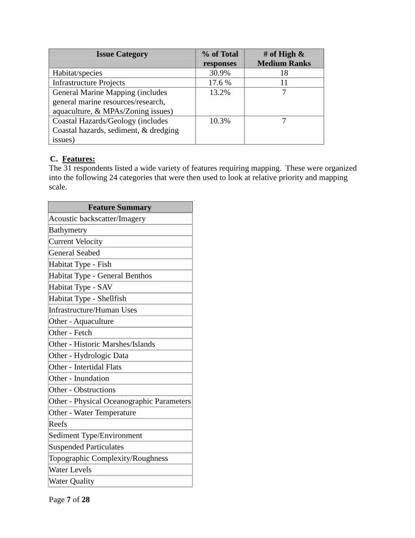
Page 7 of 28
Issue Category % of Total
responses
# of High &
Medium Ranks
Habitat/species 30.9% 18
Infrastructure Projects 17.6 % 11
General Marine Mapping (includes
general marine resources/research,
aquaculture, & MPAs/Zoning issues)
13.2% 7
Coastal Hazards/Geology (includes
Coastal hazards, sediment, & dredging
issues)
10.3% 7
C. Features:
The 31 respondents listed a wide variety of features requiring mapping. These were organized
into the following 24 categories that were then used to look at relative priority and mapping
scale.
Feature Summary
Acoustic backscatter/Imagery
Bathymetry
Current Velocity
General Seabed
Habitat Type - Fish
Habitat Type - General Benthos
Habitat Type - SAV
Habitat Type - Shellfish
Infrastructure/Human Uses
Other - Aquaculture
Other - Fetch
Other - Historic Marshes/Islands
Other - Hydrologic Data
Other - Intertidal Flats
Other - Inundation
Other - Obstructions
Other - Physical Oceanographic Parameters
Other - Water Temperature
Reefs
Sediment Type/Environment
Suspended Particulates
Topographic Complexity/Roughness
Water Levels
Water Quality

Page 8 of 28
C1. Features to be Mapped For all Issue Categories by High & Medium Priority:
According to respondents, the top ~25% of features requiring mapping for all issues according
to priority involve:
Feature % of Total
responses
# of High &
Medium Ranks
Sediment Type/Environment 28.0% 63
Bathymetry 19.3% 43
Habitat Type - General Benthos 13.4% 32
Current Velocity 10.6% 26
Habitat Type - Shellfish 6.3% 16
Note: The two entries pertaining to Habitat comprise a total of 19.7% and have 48 High or
Medium priority rankings.
C2. Features to be Mapped For All Issue Categories By Mapping Resolution:
According to respondents, the top ~25% of features requiring mapping for all issues according
to the highest concentration among mapping resolution responses involve:
Feature % of
Total
responses
# of responses comprising
the top mapping resolutions
10 x10
ft
100 to
10,000
sq ft
100 x
100 ft
Sediment Type/Environment 26.9% 21 7 18
Bathymetry 19.8% 14 5 13
Habitat Type - General Benthos 13.0% 8 3 12
Current Velocity 10.7% 10 2 6
Habitat Type - Shellfish 5.9% 5 0 3
Note: Due to a high number of varied write in responses, the category of “other” is not included
in this summary.
D. Geographic Areas:
The 31 respondents listed a wide variety of geographic areas requiring mapping. These were
organized into the following 25 categories that were then used to look at relative priority and
mapping scale.
Geographic Area Summary
All LIS - shoreline to ~10-30m
All LIS - shoreline to ~10-30m including major rivers
All LIS - shoreline to ~10-30m including major rivers & old dredge disposal areas
All LIS basin

Page 9 of 28
Geographic Area Summary
areas from Montauk west in NY waters
areas of high current velocity
as needed
beaches - Hammonasset, West Haven, Fairfield, Milford, Westbrook
beaches/eroding shorelines
Black Ledge, Holly Pond locations
Black Ledge, Thimble Islands, islands offshore Greenwich/Stamford
coastal embayments
CT River
Duck Island; east of CT River to depth of ~20 ft, CT River.
eastern LIS/Race
Hamburg Cove
LIS east of New Haven Harbor as appropriate
LIS Shellfish beds
LIS, possibly restricted to rocky/boulder areas
none listed
south of Faulkner‟s Island, mouth of CT river to past Hartford
specific areas in eastern, central, western basins
vicinity of cable/pipelines
vicinity of proposed Broadwater security zone
Waters adjacent to major harbors
D1. Geographic Areas to be Mapped For all Issue Categories by High & Medium Priority:
According to respondents, the top ~25% of geographic areas requiring mapping for all issues
according to priority involve:
Geographic Area % of Total
responses
# of High &
Medium Ranks
All LIS - shoreline to ~10-30m 48.4%% 109
All LIS basin 14.6% 31
Vicinity of cable/pipelines 5.7% 14
All LIS - shoreline to ~10-30m including
major rivers
2.8% 7
All LIS - shoreline to ~10-30m including
major rivers & old dredge disposal areas
2.8% 5
CT River 2.8% 7
Note: The three entries addressing shoreline to ~10-30m comprise a total of 54.0% and have
121 High or Medium priority rankings.
D2. Geographic Areas to be Mapped For All Issue Categories By Mapping Resolution:

Page 10 of 28
According to respondents, the top ~25% of geographic areas requiring mapping for all issues
according to the highest concentration among mapping resolution responses involve:
Geographic Area % of
Total
responses
# of responses comprising
the top mapping resolutions
10 x10
ft
100 to
10,000
sq ft
100 x
100 ft
All LIS - shoreline to ~10-30m 47.9% 15 11 48
All LIS basin 14.9% 11 5 12
Vicinity of cable/pipelines 5.8% 4 0 0
All LIS - shoreline to ~10-30m
including major rivers
2.9% 7 0 0
Note: Due to a high number of varied write in responses, the category of “other” is not included
in this summary.
In summary, it was evident that certain aspects of sea floor mapping rose to the forefront in terms
of prominence:
Issues: In terms of general categories, the top issues facing LIS management and
research reflect habitat and species, infrastructure, basic marine mapping issues, and
coastal hazards;
Features: The most important mappable features required to support the management and
reaserch concerns are sediment type, bathymetry, and habitat mapping; and
Geographic Area: Approximately half the respondents specifically identified the
nearshore to a depth of between 10m-30m as the area requiring mapping.
3.3. Workshop Results by Section:
3.3.1. Coastal Hazards & Geology: Key Issues from Surveys Used During Breakout Sessions:
Coastal Hazards and Geology included topics such as inundation from storm surge, shoreline
erosion, and sedimentation. Also included in this session were search and rescue and dredged
material management. The issue areas drawn from the surveys to stimulate the morning
breakout sessions included:
determination of shoreline change rates;
modeling storm surge inundation, sea level rise, and tidal conditions;
the accuracy of search and rescue models in shallow water;
sediment (identification of sources/transport, classification of, etc.); and
search and rescue efforts.
Morning Breakout Session Discussions:
Participants in this session noted and discussed the following topics based on the key issues
provided as well as general opinions voiced as result of the group dynamic:

Page 11 of 28
Much discussion revolved around the varieties of modeling that can support hazards
planning/hazards mitigation. However, the important distinction is that nearly all
applicable modeling requires mappable data, most notably accurate bathymetry, wind and
wave data. These mapable components should not be limited to political boundaries (i.e.
state lines, “sounds”, etc.);
Discussion of bathymetry data noted differences between nearshore data (lacking) and
deepwater data (probably good enough for current needs);
In terms of sedimentary mapping, the vertical dimension (thickness, sub-surface
distribution, etc,) must not be lost as useful information can be contained therein;
Any subsequent mapping to address any hazard needs should be cognizant of other
efforts;
Any bathymetric data collections must consider what vertical datum is most
useful/applicable (tidal? Geodetic?), and the need to integrate bathymetry with existing
or future terrestial elevation data to create seamless elevation datasets;
Sediment changes rates should be addressed on a temporal Sound-wide basis that not
only looks at the past but assesses the future for effective resource management;
Sedimentation and dredging can be thought of as complementary issues; and
Relevant hazards need not be limited to geologic based events; Spills, sediment
contaminants, water quality all can fall under a hazards umbrella that require mapping
needs.
Afternoon Group Summary and Discussion:
To focus on management needs relevant to coastal hazards and geology the group organized the
morning discussion into 6 topics, and for each, identified what the mapping requirements were
and where within the Sound data should be collected.
Infrastructure Siting: In order to mitigate against future hazards any infrastructure (large and
small scale) should be sited properly.
Requires: Bathymetry, Sediment type/class, backscatter/imagery, sub-bottom data; and
Where: Near shore, in vicinity of existing infrastructure.
Dredging/Disposal: Effective dredged material management can help with current and future
hazard planning. Knowledge of the sedimentary geology regime in a specific area can assist in a
better nexus between managing dredging, disposal, and beneficial reuse of materials to mitigate
areas of coastal erosion.
Requires: Bathymetry, Sediment type/class, backscatter/imagery, sub-bottom data,
sediment erodibility, bed stress, circulation modeling; and
Where: Near shore, embayments, representative siting/disposal areas.
Shoreline Change/Inundation: Knowledge of potential inundation from short and long term
events as well as past, present, and future shoreline changes is neccesary to properly plan for and
manage shoreline change.

Page 12 of 28
Requires: Bathymetry, Sediment type/class, backscatter/imagery, sub-bottom data,
sediment erodibility, bed stress, circulation modeling, elevation data with consistent
vertical and horizontal datums; and
Where: Near shore.
Spills, Sediment Contamination, and Water Quality: Should not be omitted from any hazards
category and can be beneficial to resource managers, planners, and researchers:
Requires: Bathymetry, sediment type/class, backscatter/imagery, sub-bottom data,
sediment erodibility, bed/shear stress, circulation modeling, sediment transport,
contaminant location and levels; and
Where: Near shore to Sound-wide.
Search and Rescue: Working and recreating in and around the water can be inherently
hazardous. Effective spatial data can help support and advance efforts in the protection of
human health and safety:
Requires: Bathymetry, sediment type/class, backscatter/imagery, sub-bottom data,
circulation modeling; and
Where: Sound-wide.
Habitat Mapping and Sustainability: Identifying and managing habitat requires many different
pieces of information, particularly these elements of critical geologic data:
Requires: Bathymetry, sediment type/class, backscatter/imagery, sub-bottom data,
sediment transport, contaminant location and levels, erodibility, ecological site
description, connectivity history; and
Where: Near shore to Sound-wide.
Session Summary:
Hazards and geology needs span many topical areas, but critical mapping needs to support
management to focus on bathymetry, sediment type/class, backscatter/imagery, and sub-bottom
data spanning the either the whole Sound or at least focused in the near-shore environment. No
formal definition of “near-shore” was agreed upon, but the general consensus was to acquire
data in areas where existing “deep-water” data ends.
3.3.2. Infrastructure: Key Issues from Surveys Used During Breakout Sessions:
As used here, infrastructure is meant to be the technical services that support society such as
dredged navigation channels, telecommunications (cables), energy (cables & pipelines) and
alternate energy (wind and tidal projects). The issue areas drawn from the surveys to stimulate
the morning breakout sessions included:
using geospatial data to evaluate the environmental impacts of the installation of cables
and pipelines, and with such assessment, identify impacted areas and areas that show
recovery;

Page 13 of 28
using geospatial data to pre-identify identify potential utility corridors within which
utility siting and installation will have the least impact; and
using geospatial data to identify appropriate areas for hydrokinetic or other renewable
energy resources.
Morning Breakout Session Discussions:
Participants at the workshop identified the traditional infrastructure such as those listed above
but then went onto develop a list of other types of structures that are not classically included
under infrastructure such as armored shorelines (e.g., erosion control), cooling water in-takes,
tide gates, flood control structures, docks and marinas, and others. In retrospect, it would have
been helpful to provide the participants with a definition of infrastructure. Several commentors
noted how the location of upland facilities may drive the planning for utility infrastructure.
Based on the discussion in this session, for general planning purposes the following resource
data layers at a small scale were identified to be necessary, but are not limited to:
substrate;
sediments;
depositional vs. erosional areas;
geology and bed stress (subsurface geology);
bathymetry;
benthic habitats and communities (note: long-term data sets are needed);
wind; and
current speed and direction.
For utility projects and their impacts, the spatial data would need to be at large scale and related
to specific project locations. It was suggested that the following data be collected:
baseline data prior to installation/existing site conditions;
installation impacts; and
post-installation recovery over periods of time.
It is noted that these projects are generally one-time impacts, but may have some localized
maintenance needs/intermittent impacts.
Afternoon Group Summary and Discussion:
Summary recommendations from this session presented to the group are as follows:
gather existing condition data layers (infrastructure and resources) at a small/large scale
for all of LIS;
study impacts of existing utility installation on substrate, benthic communities and/or on
other ecosystems at a large/small scale, as applicable;
use results of utility impact analysis to determine future utility project locations; and
identify the locations of existing LIS resources and infrastructure to determine potential
locations for protection and development.

Page 14 of 28
Session Summary:
Initially, the Infrastructure session discussion focused on the need to capture as much
information as possible about existing conditions within the Sound for better planning and
decision making with regard to the placement, monitoring and maintenance of infrastructure,
particularly as it relates to cross-sound applications. However, the discussion went on to develop
a list of nearshore structures that are more traditionally associated with residential, marine
commercial and flood control activities, in addition to the larger facilities associated with energy
and telecommunications generation and transmission within the Sound. The location of upland
facilities associated with in-water infrastructure was also identified as an important feature. The
development of this discussion related to near-shore infrastructure highlighted the need for
mapping in these nearshore shallow water areas.
3.3.3. General Mapping and Ocean Management: Key Issues from Surveys Used During Breakout Sessions:
General Mapping & Ocean Management captured recommendations for mapping all of the
Sound for a specific purpose. Ocean management was used to capture concepts such as marine
zoning, marine protected areas and reference (long-term monitoring) sites. The issue areas
drawn from the survey used to stimulate the morning breakout sessions included:
the need to have a complete set of spatial data for the bottom of Long Island Sound in
order to support planning, identification of unique and critical locations, an understanding
of the spatial connectivity between unique and critical locations, and assessment of
impacts from infrastructure such as cables and pipelines;
all areas of the Sound should be mapped including the embayments and mouths of tidal
rivers. Spatial data proposed to be collected includes:
o bathymetry;
o sediment type;
o biomass;
o depositional and erosional areas;
o current velocity and patterns;
o biogenic habitats such as kelp beds and mollusc forming reefs;
o human activities;
o acoustic backscatter;
o habitat type; and
o identification of essential fish habitat;
current mapping surveys use vessels that are large and thus cannot access shallow water,
creating gaps between the existing mapping and the land. This gap was also identified as
a priority area for mapping given that many human-induced impacts occur in nearshore
areas, and that these areas tend to support diverse and productive habitats for marine
species and wildlife;
the importance of acquiring high resolution bathymetric data, with emphasis on the
nearshore zone in order to support the development of storm surge models, the

Page 15 of 28
development of circulation models to support sediment fate and transport and the
modeling of harmful algae blooms; and
need for geospatial data for shipwrecks.
Morning Breakout Session Discussions: The following were identified as issues/needs regarding marine management that would benefit
from geospatial data:
marine management would benefit from a zoning approach that utilizes geospatial data to
identify geographic areas and their use suitability;
geospatial data could be used to plan for marine protected areas:
o in general;
o specifically if the Broadwater LNG facility had been permitted;
geospatial mapping would have provided baseline data in an area that
would have become a de facto reserve through the implementation of a
security zone. Analyziing future changes to such a zone could help to
evaluate the value of reserves and the overall impact to bottomlands from
existing uses; and
o acquisition of geospatial data in and outside of areas where trawling is allowed; a
comparison between areas may provide resource managers with new insights as to
the value of reserves and the impacts, if any, from trawling;
identifying areas that could serve as „reference sites‟ (sites that are typically the least
impacted and perhaps natural, that serve as a reference sites for areas that are modified by
human activity);
identifying known or discovering new shipwreck sites;
geospatial data could help in managing and identifying Native American/culture heritage
sites; and
geospatial data could be used to identifying marine debris and abandoned fishing gear to
identify those areas requiring cleanup operations or as areas to be avoided by mariners.
Afternoon Group Summary and Discussion:
Summary recommendations from this session presented to the group are as follows:
Need planning level maps:
o Activities to be mapped:
Infrastructure;
Marine zoning (if approved in the future);
Marine Protected Areas (MPAs) (if approved in the future);
Essential Fish Habitat (EFH); and
Aquaculture.
o Mapping elements:
Bathymetry;
Sediment type;
Habitat;
Bottom images;
Bottomland ownership; and

Page 16 of 28
Cultural resources;
Shipwrecks; and
Native American heritage sites/resources.
Need point of collaboration:
o Piggy-backing on data collection;
o Need standards for multiple users; and
o Collaborative funding.
Data standards:
o Metadata;
o Quality Assurance; and
o Want to integrate topographic and seafloor maps.
Public outreach/involvement:
o Open-source products;
o User-friendly products: simple mapping tools, e.g., Google Earth;
o Need to develop public support; and
o Need input from public, industry, non-governmental organizations, academia.
Get existing data digitized and on-line;
Need temporal sampling;
Data intensity; and
Integrate data and models for many issues.
Session Summary:
The General Mapping and Ocean Management survey responses identified that many of the
participants were interested in mapping the near-shore shallow areas of the Sound and the
associated embayments and mouths of rivers to capture essential fish habitat and aquaculture
areas. The limitations of traditional technology associated with mapping these near-shore
shallow water areas was raised as a concern among participants. The session discussions and
summary highlighted to the need for utilizing existing data collection and mapping efforts as a
basis for beginning this effort, and that additional systematic benthic data collection and mapping
in both near-shore and deep water areas, particularly as this data may provide comparison
opportunities between marine protected areas or relatively undisturbed reference sites and
specified areas within which industrial and commercial activities have occurred and have created
benthic alterations or disturbances. Public outreach and involvement was also discussed to
ensure that data is available to the public and all user groups, suggesting that a central repository
for map data be established and maintained. Session participants also identified a number of
cultural features that may be captured to further efforts to preserve and protect these underwater
resources.
3.3.4. Habitat & Species: Key Issues from Surveys Used During Breakout Sessions:
Habitats are the seafloor area or environment where an organism or ecological community
normally lives or occurs. In contrast, any spatial mapping need for an individual organism is
categorized as Species. The issue areas drawn from the survey to stimulate the morning breakout
sessions included:

Page 17 of 28
characterization of the habitat (e.g., by sediment type, erosional/sedimentation areas or
biogenic habitats) for important sepcies of fish and invertebrates (e.g., essential fish
habitat or habitats of particular concern);
mapping shellfish resources Sound-wide in the nearshore zone (less than 30‟) including
embayments;
identification and delineation of the habitat of sand lance to determine if the formation of
hypoxia reduces the habitat of this species and thus its abundance; and
identification and delineation of the spawning habitat for silversides so it would be
possible to evaluate the potential impact to this habitat from various uses, including
aquaculture.
The issues related to habitat needs included:
mapping submerged aquatic vegetation (rooted) such as eelgrass (Zostera marina), and
the numerous species present in fresh tidal and brackish tidal waters;
mapping of macrophytes with an emphasis on rocky habitat;
mapping of molluscan reefs (i.e., mussels and oysters) including natural and managed
oyster beds;
need for habitat mapping in order to support management and conservation of habitats
and species, especially the identification of communities with complex physical structure
(e.g., boulder reefs, topographic rises and shoals). The complex sites tend to support
vulnerable communities with slow recovery times due to slow growth rates or
unpredictable recovery due to the vagaries in recruitment;
mapping of those species that are important diet species to waterbirds such as Gemma
gemma and blue mussels (Mytilus edulis) in order to help understand waterbird use of the
Sound and possible relationship between waterbird abundance and available food
resources;
mapping and classification of reefs in order to quantify their availability and respond to
public suggestions for the creation of reefs in the Sound to improve fishing; and
the identification of historic wetland1 and inland extent to support the evaluation of
restoration options.
Morning Breakout Session Discussions:
The workshop session for species and habitats spent the majority of time discussing how one
would map species and habitats rather than delving further into the species or habitat issues that
needed geospatial data to advance management or scientific questions and needs. The few
species and habitat issue specific comments that were identified are listed as follows:
need to understand existing and historical distribution of SAV & macrophytes, this would
including mining historic data and research2;
1 The shorelines and wetland boundaries from the 1880 Coast and Geodetic Charts (aka Topographic Sheets) have
been georeferenced and are available as shapefiles. 2 This has been done for Zostera marina and the data is available online at
http://www.lisrc.uconn.edu/eelgrass/index.html). There is a report for the Connecticut River SAV beds including a
comparison to a historic survey at the following website

Page 18 of 28
need to map landscape drivers that drive biological community formation;
need a comprehensive retrospective of what we already know;
need spatially comprehensive inventories/mapping of LIS capturing communities/species
and habitats as a foundation for ecosystem based management; and
need to create a model that would establish a relationship between habitats and the
species present in those habitats.
The information that was „parked‟ from the session is contained in Appendix D.
Afternoon Group Summary and Discussion:
The group put together the following summary that was presented back to the larger workshop
group. Rather than a list of recommendations they attempted to frame a process characterized by
a primary issue related to habitat and species management and how one would address it via
seafloor mapping.
PRIMARY ISSUE:
o Insufficient management tools to make informed decisions about resources and
sustainability;
NEEDS:
o Spatially comprehensive mapping of LIS, capturing species and habitats as a
foundation for Ecosystem Based Management;
APPROACH:
o Inventory of habitat communities using a landscape framework;
o Habitat-community associations,
o Incorporation of multiple data layers,
o Habitat connectivity, and
o Temporal & spatial scaling.
ATTRIBUTES:
o Geospatial inventory of habitats and communities; and
o Landscape drivers;
Seafloor geology,
Temperature,
Salinity,
Light,
Dissolved oxygen,
Turbidity,
Current, and
Social & economic uses.
Habitat forming species/communities/biogenic features;
Physically structured complex habitats;
Human altered habitats; and
(http://www.lisrc.uconn.edu/DataCatalog/DocumentImages/pdf/Barrett_et_al_1997.pdf).

Page 19 of 28
Retrospective historical data.
Session Summary:
The Habitat and Species discussion appeared to be the most problematic session for participants,
as the topics were very broad and likely contained too wide a variety of issues to identify in a
single afternoon. It is important to note that this was the most well attended session and
benefitted from participation of the most diverse group of stakeholders and interests.
Participants in this session tended to agree that comprehensive mapping of all of Long Island
Sound was critical. Participants also identified specific data collection that is needed to manage
habitats and species including, but not limited to benthic geology, habitat forming species and
communities such as molluscan reefs and corals, human altered habitats, and physically
structured habitats such as rocky bottoms and shoals. There was further discussion regarding
pelagic habitats and how to capture features that are more difficult to map in a traditional sense,
but these discussions were tabled, as they do not lend themselves well to traditional mapping
efforts.
4. Prioritization & Next Steps: During the final facilitated discussion among all of the participants, the following common
themes and priorities arose, suggesting what some “next steps” could be in terms of sea floor
mapping:
There is a need for a complete high resolution base bathymetric map of Long Island
Sound as a starting point for comprehensive seafloor mapping;
There is a need to identify the extent of geographic scope of the mapping project (e.g.
how far up the major rivers do we want to map?);
There is a need to determine what map products for Long Island Sound currently exist,
and what areas have not been adequately mapped so that we can identify and fill these
gaps;
There is a need to specify data collection techniques and standards as well as data storage
and access guidelines to ensure that the final map product(s) are adequate for use by all of
the various user groups and are accessible to coastal managers, the scientific community,
academia, and the general public;
Shallow water areas are important to map because of the natural resources that are known
to exist in these areas and because of the wide variety of human impacts that often occur
closest to the land-water interface. Participants noted that shallow water area mapping
poses logistical and technical difficulties in terms of data collection and these logistics
need to be resolved; and
Once we have collected data for and compiled a comprehensive base bathymetric map for
Long Island Sound, there are many questions regarding what map data should be
collected next. Participant suggestions were extensive, and included such major
categories as habitat type, geology, sediment type and quality, cultural features, water
quality, current velocity and patterns, social and economic uses, nearshore infrastructure
and human uses, depositional and erosional areas, and biomass.

Page 20 of 28
APPENDIX A:
Seafloor Mapping Workshop
Fort Trumbull State Park
90 Walbach Street, New London,
Connecticut
November 28, 2007
8:00 AM: Registration and Continental Breakfast
8:30 AM: Welcome and Introductions:
Brian P. Thompson, Director, DEP Office of Long Island Sound Programs
Dr. Peter Auster, UCONN Department of Marine Sciences/NURC
Mark Tedesco, Director, EPA Long Island Sound Study
8:45 AM: Ground Rules and Workshop Format – Robert LaFrance, Lead Facilitator
9:00 AM: Facilitated Sessions (Assigned)
A. General Mapping and Spatial Ocean Management
B. Habitats and Species
C. Coastal Hazards and Geology
D. Infrastructure
10:00 AM Participants May Transition to Second Choice Break-Out Session
10:30 AM Break
10: 45 AM Participants May Transition to Third Choice Break-Out Session
11:15 AM Participants May Transition to Fourth Choice Break-Out Session
12:00 PM Lunch Break
1:00 PM Summary Session A – General Mapping and Spatial Ocean Management
1:20 PM Summary Session B – Coastal Hazards and Geology
1:40 PM Summary Session C – Infrastructure
2:00 PM Summary Session D – Habitats and Species

Page 21 of 28
2:20 PM Prioritization of Issues
2:40 PM Break
3:00 PM Discussion
3:30 PM Next Steps
4:00 PM Wrap-Up – Brian Thompson

Page 22 of 28
APPENDIX B:
The workshop master facilitator was Robert LaFrance from DEP‟s Office of Planning and
Program Development. The EPA Narragansett Bay Laboratory in Rhode Island provided the
following facilitators to manage the four breakout sessions:
Marty Chintala - Habitats and Species;
Roxanne Johnson – Infrastructure;
Walt Galloway - Coastal Hazards and Geology; and
Walter Berry - General Mapping and Spatial Ocean Management.
Each session had a technical session lead. The session leads were:
Peter Auster – UCONN/NURC - Habitats and Species;
Susan Jacobson – DEP OLISP - Infrastructure;
Kevin O‟Brien – DEP OLISP - Coastal Hazards and Geology; and
Ron Rozsa – DEP OLISP - General Mapping and Spatial Ocean Management.
Each session had note takers. The note takers were:
Elizabeth Pillsbury – EPA LISS Fellow – Habitats and Species;
Carlos Esguerra - DEP OLISP – Infrastructure;
Joel Johnson – DEP OLISP – Coastal Hazards & Geology; and
Tom Ouellette - DEP OLISP – General Mapping and Spatial Ocean Management.

Page 23 of 28
APPENDIX C:
SEAFLOOR MAPPING DATA AND ISSUES NEEDS WORKSHEET Deadline: November 1, 2007
Name: Institution/Agency/Organization: Address: Phone: Email: Complete one worksheet for each issue/data need: What are the key management issues in Long and Fishers Island Sounds that a benthic mapping initiative could address by either producing new map products or derivative products from existing data? What are the relative priorities of the issues identified above?
____“high” = immediate to short term;
____“medium” = not immediate but required over the next few years;
____“low” = long term planning horizon What kinds of information would need to be displayed in a geographic context? (e.g. bathymetry, sediment type, current velocity). What is the geographic area(s) that require mapping effort? Be as specific or general as applicable (e.g., shallow versus deep; particular habitat types, specific geographic locations) How small of a mapping unit do you need to resolve features of interest? (e.g., rocks larger than 5’ x 5’,
eelgrass beds greater than 50‟ x 50‟, etc.) ____1 x 1 ft
____10 x 10 ft
____100 x 100 ft
____1000 x 1000 ft
____other, describe: Please email worksheets to Kate Brown at ([email protected]) by November 1, 2007.

Page 24 of 28
APPENDIX D:
PARKING LOT OF ISSUES/COMMENTS
Identify other habitats to map
Classifying Groups
Hab. forming communities – animals -> non-photo
Hab. forming communities – plants -> photo
Structural features (physical) – boulders, etc.
Link Biology & Geology
Separate Issues & Processes
Map on Sound-wide scale & then specific habitats
Inland [sp?] habitats -> one of specific habitats
Habitats disturbed by human activity
Focus on habitats and species
Boundaries? (Are we actually capturing them by classifying groups?)
Sound-wide Landscape issues as
o Broad scale
o Small scale - then focus on specific habitats ------------- FRAMEWORK
GIS layers for spatially comprehensive mapping -------LANDSCAPE DRIVERS
o Geologic
o Temp
o Salinity
o Light
o DO
Differentiate between mapping habitat and underlying drivers
o Proxies to map habitat
o Hard to map biological comm. ->goal is to map bio comm.
o Need to make sure issues are addressed
Need to develop ways of mapping organisms
Need to map that can support econ/ecologically important species
Help ID where
things might be

Page 25 of 28
HUGE ISSUE: why plants and animals are where they are & why aren‟t they where they
aren‟t
Need to prioritize habitats and species we are concerned about:
o Essential shorebird habitat
o Essential Fish habitat
o Essential Lobster Habitat
Encompass mud flats
o Managers need good data on benthic resources
o Whether on core scale or not
o Mosaic, ecosystem approach, not split
mosaic then cutouts for specific habitats
o How habitats are functioning?
Seek to describe communities
o Could then be assessed over time
Pelagic habitat
Comprehensive survey of benthic inhabitants
Geospatial Data
Inventory of habitats/communities
Need to couch in accessible/attractive language
Primary Issue:
Insufficient management tools to make informative decisions about resources – management
& sustainability
Need to identify social and economic uses of diff ecosystems -> map layers
What are attributes we need to map?
MAPPING
Inventory of Habitats/Comm
o Plants & animals -> biogenic
o Physically structured geology
o Human altered
Retrospective Analysis & Time Series Data
Historic geospatial data

Page 26 of 28
Historical framework
Want consistent approaches going forward
o To frame data
o To frame work going forward

Page 27 of 28
ACRONYMS:
CEAB – Connecticut Energy Advisory Board
EPA – Environmental Protection Agency
LIDAR – Light Detection and Ranging
LISS – EPA Long Island Sound Study, a National Estuary Program
NURC – National Underwater Research Center
OLISP – Office of Long Island Sound Programs
UConn – University of Connecticut
USGS – Unites States Geology Survey
MPA‟s – Marine Protected Areas

Page 28 of 28
BIBLIOGRAPHY:
California Ocean Protection Council. Strategic Planning Workshop for California Marine
Habitat Mapping - http://seafloor.csumb.edu/StrategicMappingWorkshop.htm
Barrett, Juliana M., et al. 1997. Distribution and Abundance of Submerged Aquatic Vegetation
in the Lower, Tidal, Connecticut River.
Connecticut Academy of Science and Engineering. 2004. Long Island Sound Symposium: A
Study of Benthic Habitats.
Gulf of Maine Council on the Marine Environment. Gulf of Maine Mapping Initiative -
http://www.gulfofmaine.org/gommi/
Institute for Sustainable Energy. 2003. Comprehensive Assessment and Report - Part I Energy
Resources and Infrastructure of Southwest Connecticut.
Institute for Sustainable Energy. 2003. Comprehensive Assessment and Report - Part I
Environmental Resources and Energy Infrastructure of Long Island Sound.
Long Island Sound Resource Center. Cooperative Geologic Investigations Of Long Island
Sound – http://www.lisrc.uconn.edu/lisrc/geology.asp
Long Island Sound Resources Center. Establishing Restoration Objectives for Eelgrass in Long
Island Sound - http://www.lisrc.uconn.edu/eelgrass/index.html.
USGS Woods Hole Science Center. USGS Studies in Long Island Sound:
Geology, Contaminants, and Environmental Issues - http://woodshole.er.usgs.gov/project-
pages/longislandsound/index.htm