looking at the archaeology the auger survey - heritage … · p1 of 5 looking at the archaeology b...
TRANSCRIPT

p1 of 5 Looking at the archaeology
Bolingbroke Castle
Looking at the archaeology
The auger survey
The auger survey allowed us to look at the archaeology
of the moat without having to damage it by excavation. It
involved taking a series of narrow cores down through the fill
of the moat so that we could study the different layers that
had built up over time. We wanted to use the information
to make sure that when the moat restoration work was
carried out we knew how deep the modern silt was and
could excavate it without damaging any of the underlying
archaeology. We also wanted to take the opportunity of
discovering as much as we could about the history of the
moat and the castle in the process.
How the auger survey was carried out
We started by measuring out a series of straight lines
(transects) across the parts of the moat that were going to
be de-silted. We then marked a number of points at regular
intervals along each line. The auger survey was carried out
in the summer and we found that the vegetation and silting
in the moat had built up to such an extent that we were able
to easily walk across it without wellingtons. In the winter
months the ground conditions would usually be wetter.
The cores were taken at each of the marked points using an
auger, which is a long metal tube-shaped cutting tool with a
handle on the top for pushing it down into the ground. The
auger is 25mm in diameter and its basic 1m length can be
extended by adding extra lengths of tube depending on how
deep the cores need to go. In this case we kept going until
we reached the natural clay that forms the bottom of the
medieval moat. The only places where it was not possible to do this was at the ends
of the transects nearest to the castle walls. Here we found it was not possible to
auger deeper than about 0.3 metres. Each core taken was carefully analysed and
recorded and the results were used to build up cross-
John F
arro
w

p2 of 5 Looking at the archaeology
Bolingbroke Castle
sections of the different levels of the fill of the
moat. We also took samples from the cores
at regular intervals so that we could look for
other evidence, including any plant pollen that
was present in them. By looking for pollen we
hoped to be able to find out what sorts of plants
had been growing in the area at different times
during the castle’s history and get an idea of what the landscape may have been
like and if it had changed over time. We also hoped to be able to radiocarbon date
some material from near the bottom of the moat. If the date coincided with the
date that the castle was built (around 1220) we would know that the medieval moat
had not been cleared out to its bottom since that time.
What we found out
The depth of the medieval moat: The cores allowed us to measure the depth of
the moat to the natural clay. We found that the bottom of the medieval moat was
quite uneven but that its average depth was about 2.27 metres below the moat
surface at the time of the survey. The water level would most probably have been
higher during the medieval period as the moat came right up to the castle walls.
This means that it could originally have been about 3 metres deep. It is likely that
the water level was maintained by channelling water from the nearby stream which
runs along the opposite side of Moat Lane to the castle.
The width of the moat: The medieval moat was wider than it appears today. As
we have already seen, on the castle side the water would have included the area
which is now the modern grass pathway
around the outside of the walls. Also on its
opposite side the auger survey did not identify
the bank of the moat closest to Moat Lane,
which suggests that it lay no closer than the
modern road and that the road could be sited
on the original moat bank. This would mean
that the original medieval moat was at least
40 metres wide.
John F
arro
w
HTL
p3 of 5 Looking at the archaeology
Bolingbroke Castle
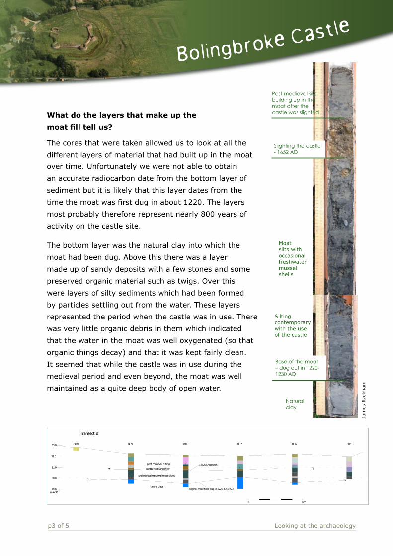
Post-medieval silts building up in the moat after the castle was slighted
Slighting the castle - 1652 AD
Base of the moat – dug out in 1220-1230 AD
Moat silts with occasional freshwater mussel shells
Silting contemporary with the use of the castle
Natural clay
What do the layers that make up the
moat fill tell us?
The cores that were taken allowed us to look at all the
different layers of material that had built up in the moat
over time. Unfortunately we were not able to obtain
an accurate radiocarbon date from the bottom layer of
sediment but it is likely that this layer dates from the
time the moat was first dug in about 1220. The layers
most probably therefore represent nearly 800 years of
activity on the castle site.
The bottom layer was the natural clay into which the
moat had been dug. Above this there was a layer
made up of sandy deposits with a few stones and some
preserved organic material such as twigs. Over this
were layers of silty sediments which had been formed
by particles settling out from the water. These layers
represented the period when the castle was in use. There
was very little organic debris in them which indicated
that the water in the moat was well oxygenated (so that
organic things decay) and that it was kept fairly clean.
It seemed that while the castle was in use during the
medieval period and even beyond, the moat was well
maintained as a quite deep body of open water.
? ?
BH5BH6BH7BH8BH9BH10
? ?
Transect B
33.0
32.0
31.0
30.0
29.0m AOD
S
1652 AD horizon!
undisturbed medieval moat silting
original moat floor dug in 1220-1230 AD
S
natural clays
post-medieval silting
rubble and sand layer
Bolingbroke Castle Moat Section
0 5m
Jam
es R
ackh
am

p4 of 5 Looking at the archaeology
Bolingbroke Castle
The next layer above was very different in character.
It consisted of a layer made up of stones and sand.
These were fragments of Spilsby sandstone which is
the same stone that the castle is built of. When we
were taking the samples this layer had been quite
difficult to auger through. We could tell by the cores
that it had not built up gradually in the same way
as the ones below it but that it was the result of one
particular event. We interpreted this layer as representing the point at which the
castle was slighted by the parliamentarians in the mid 1600s at the end of the Civil
War. It was largely destroyed so that it could never be used for defensive purposes
by the king’s supporters again. The stone from parts of the castle walls had
evidently fallen into the moat and had remained there ever since.
The levels above this reverted to the same gradually deposited silty sediments
that we had found in the layers below it. This indicates that the moat continued to
be water filled after the castle was ruined. However, without regular maintenance
vegetation would gradually have spread into the water and taken it over. We know
from aerial photographs that by the time
archaeologists started to excavate the castle in
the 1960s the moat had dried up. The photos
also show that they partially dug it out and we
know that it contained mostly open water in
the 1990s.
What did the pollen samples tell us?
Samples of the cores were examined for the presence of plant pollen. By looking at
the different types of pollen it was possible to determine what plant species they
had come from. As a result of this we were able to tell that:
Some of the pollen came from water plants. We found that there was very little pollen from
floating water plants in the lower silt layers (before the slighting of the castle in the mid 1600s)
but much more in the layers from after that time. This supported the observations that we had
made from looking at the auger cores that the moat was most probably kept clear of pond weed
and maintained as a body of clear open water while the castle was in use but that it was not so
well maintained afterwards and was gradually taken over by floating water plants.
•
© C
UCAP
p5 of 5 Looking at the archaeology
Bolingbroke Castle
There were plants such as reed mace (bulrushes), bur reed and
various sedges growing at the margins of the moat throughout its life.
There was very little tree and shrub pollen which indicates that the
medieval and later landscape around the castle has never been
heavily wooded.
There were large numbers of grass pollens. Some of these could
have come from plants growing around the fringes of the moat but
it is likely that grassland and pasture was an important part of the
surrounding countryside, especially as there was also pollen from
other plants that grow in areas of pasture, such as dandelions and daisies.
There was pollen from cereal crops such as wheat, barley and rye, and plants that have
traditionally grown in arable fields, such as blue cornflower. However, the presence of these does
not necessarily mean that large amounts of crops were being grown in the immediate area. The
pollen could have come from the rubbish and other waste generated by life in the castle. Cereals
would have been used as floor coverings which were periodically swept out and renewed, but more
importantly they would have been brought into the castle from elsewhere for food, both for people
and for animals, and the pollen would have passed through their digestive systems. We know that
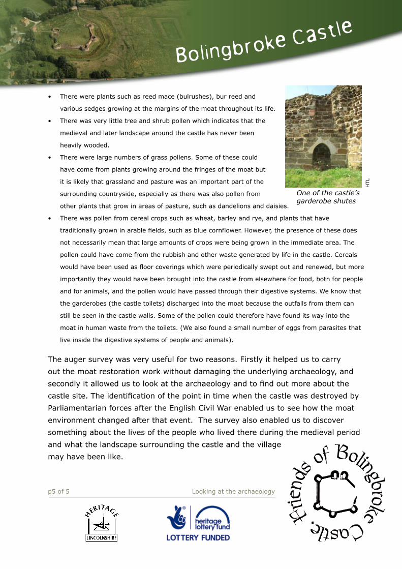
the garderobes (the castle toilets) discharged into the moat because the outfalls from them can
still be seen in the castle walls. Some of the pollen could therefore have found its way into the
moat in human waste from the toilets. (We also found a small number of eggs from parasites that
live inside the digestive systems of people and animals).
The auger survey was very useful for two reasons. Firstly it helped us to carry
out the moat restoration work without damaging the underlying archaeology, and
secondly it allowed us to look at the archaeology and to find out more about the
castle site. The identification of the point in time when the castle was destroyed by
Parliamentarian forces after the English Civil War enabled us to see how the moat
environment changed after that event. The survey also enabled us to discover
something about the lives of the people who lived there during the medieval period
and what the landscape surrounding the castle and the village
may have been like.
•
•
•
•
HTL
One of the castle’s garderobe shutes