looking for yemen's hidden treasure - schlumberger
TRANSCRIPT
CYAN MAGENTA YELLOW BLACK
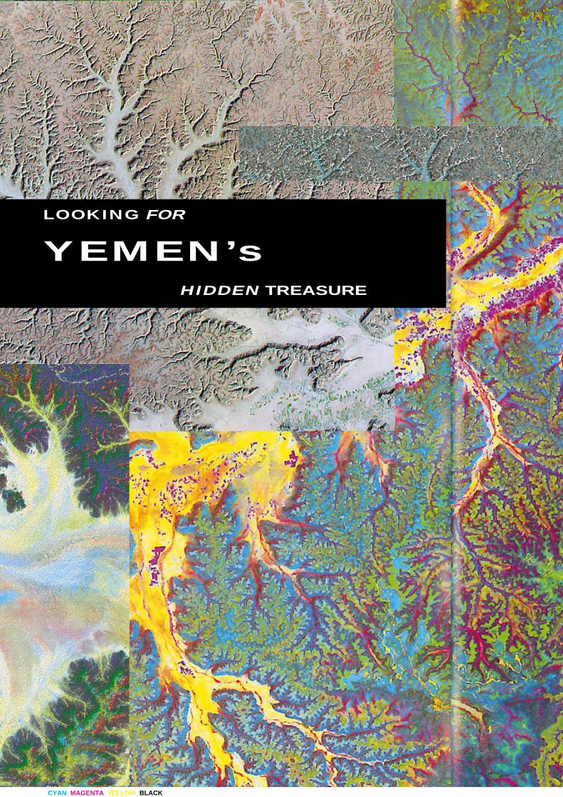
LOOKING FOR
YEMEN’sHIDDEN TREASURE
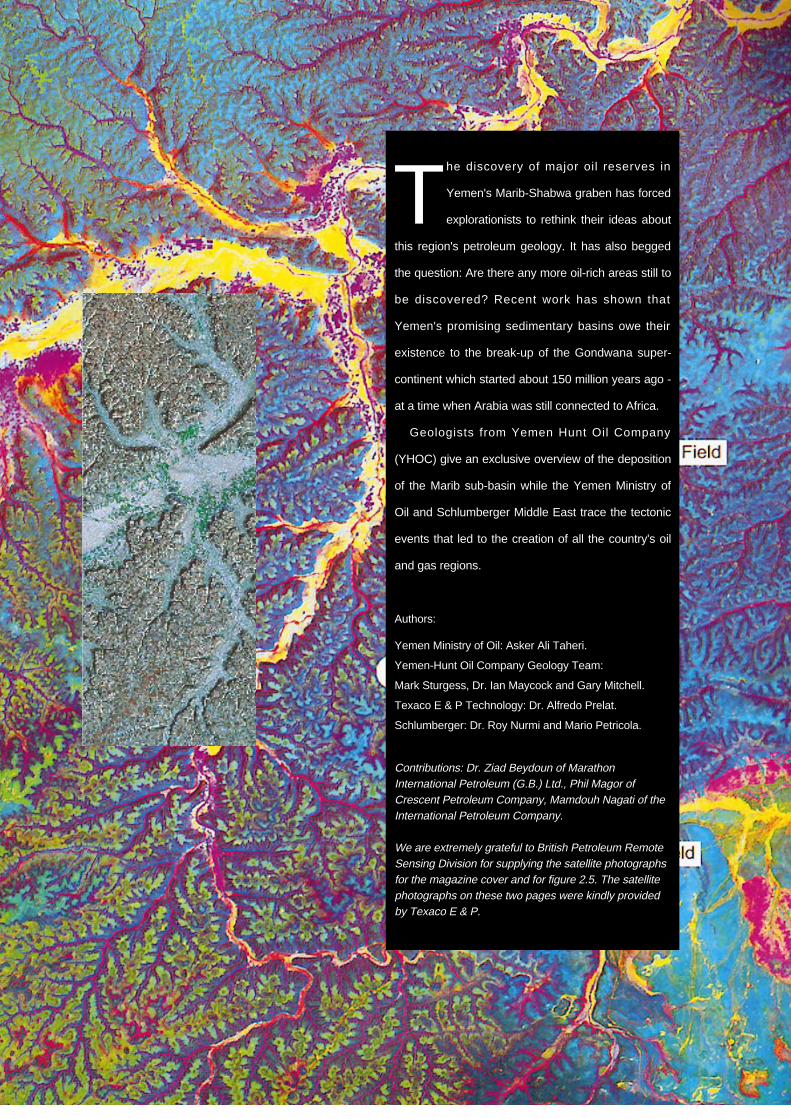
The discovery of major oil reserves in
Yemen's Marib-Shabwa graben has forced
explorationists to rethink their ideas about
this region's petroleum geology. It has also begged
the question: Are there any more oil-rich areas still to
be discovered? Recent work has shown that
Yemen's promising sedimentary basins owe their
existence to the break-up of the Gondwana super-
continent which started about 150 million years ago -
at a time when Arabia was still connected to Africa.
Geologists from Yemen Hunt Oil Company
(YHOC) give an exclusive overview of the deposition
of the Marib sub-basin while the Yemen Ministry of
Oil and Schlumberger Middle East trace the tectonic
events that led to the creation of all the country's oil
and gas regions.
Authors:
Yemen Ministry of Oil: Asker Ali Taheri.
Yemen-Hunt Oil Company Geology Team:
Mark Sturgess, Dr. Ian Maycock and Gary Mitchell.
Texaco E & P Technology: Dr. Alfredo Prelat.
Schlumberger: Dr. Roy Nurmi and Mario Petricola.
Contributions: Dr. Ziad Beydoun of MarathonInternational Petroleum (G.B.) Ltd., Phil Magor ofCrescent Petroleum Company, Mamdouh Nagati of theInternational Petroleum Company.
We are extremely grateful to British Petroleum RemoteSensing Division for supplying the satellite photographsfor the magazine cover and for figure 2.5. The satellitephotographs on these two pages were kindly providedby Texaco E & P.
CYAN MAGENTA YELLOW BLACK
14 Middle East Well Evaluation Review
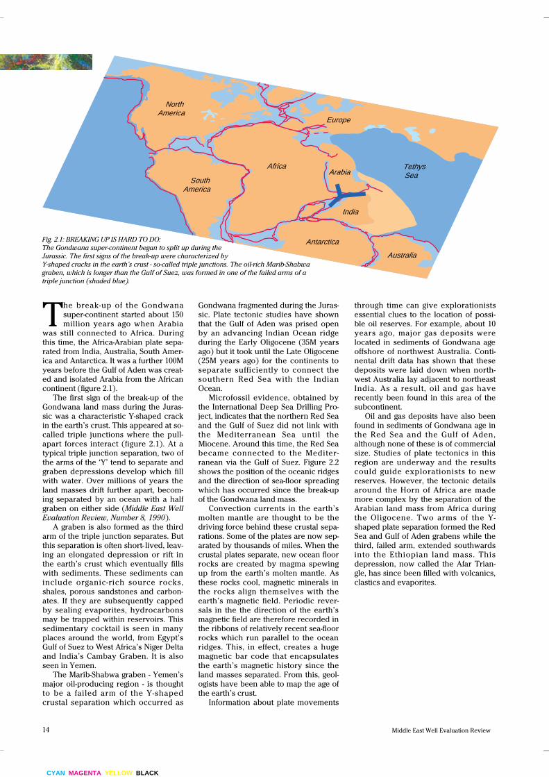
Fig. 2.1: BREAKING UP IS HARD TO DO:
The Gondwana super-continent began to split up during the
Jurassic. The first signs of the break-up were characterized by
Y-shaped cracks in the earth’s crust - so-called triple junctions. The oil-rich Marib-Shabwa
graben, which is longer than the Gulf of Suez, was formed in one of the failed arms of a
triple junction (shaded blue).
The break-up of the Gondwana
super-continent started about 150
million years ago when Arabia
was still connected to Africa. During
this time, the Africa-Arabian plate sepa-
rated from India, Australia, South Amer-
ica and Antarctica. It was a further 100M
years before the Gulf of Aden was creat-
ed and isolated Arabia from the African
continent (figure 2.1).
The first sign of the break-up of the
Gondwana land mass during the Juras-
sic was a characteristic Y-shaped crack
in the earth’s crust. This appeared at so-
called triple junctions where the pull-
apart forces interact (figure 2.1). At a
typical triple junction separation, two of
the arms of the ‘Y’ tend to separate and
graben depressions develop which fill
with water. Over millions of years the
land masses drift further apart, becom-
ing separated by an ocean with a half
graben on either side (Middle East WellEvaluation Review, Number 8, 1990).
A graben is also formed as the third
arm of the triple junction separates. But
this separation is often short- lived, leav-
ing an elongated depression or rift in
the earth’s crust which eventually fills
with sediments. These sediments can
include organic-rich source rocks,
shales, porous sandstones and carbon-
ates. If they are subsequently capped
by sealing evaporites, hydrocarbons
may be trapped within reservoirs. This
sedimentary cocktail is seen in many
places around the world, from Egypt’s
Gulf of Suez to West Africa’s Niger Delta
and India’s Cambay Graben. It is also
seen in Yemen.
The Marib-Shabwa graben - Yemen’s
major oil-producing region - is thought
to be a failed arm of the Y-shaped
crustal separation which occurred as
Africa
India
Australia
Arabia South
America
North America
Europe
Antarctica
Tethys Sea
through time can give explorationists
essential clues to the location of possi-
ble oil reserves. For example, about 10
years ago, major gas deposits were
located in sediments of Gondwana age
offshore of northwest Australia. Conti-
nental drift data has shown that these
deposits were laid down when north-
west Australia lay adjacent to northeast
India. As a result, oil and gas have
recently been found in this area of the
subcontinent.
Oil and gas deposits have also been
found in sediments of Gondwana age in
the Red Sea and the Gulf of Aden,
although none of these is of commercial
size. Studies of plate tectonics in this
region are underway and the results
could guide explorationists to new
reserves. However, the tectonic details
around the Horn of Africa are made
more complex by the separation of the
Arabian land mass from Africa during
the Oligocene. Two arms of the Y-
shaped plate separation formed the Red
Sea and Gulf of Aden grabens while the
third, failed arm, extended southwards
into the Ethiopian land mass. This
depression, now called the Afar Trian-
gle, has since been filled with volcanics,
clastics and evaporites.
Gondwana fragmented during the Juras-
sic. Plate tectonic studies have shown
that the Gulf of Aden was prised open
by an advancing Indian Ocean ridge
during the Early Oligocene (35M years
ago) but it took until the Late Oligocene
(25M years ago) for the continents to
separate sufficiently to connect the
southern Red Sea with the Indian
Ocean.
Microfossil evidence, obtained by
the International Deep Sea Drilling Pro-
ject, indicates that the northern Red Sea
and the Gulf of Suez did not link with
the Mediterranean Sea until the
Miocene. Around this time, the Red Sea
became connected to the Mediter-
ranean via the Gulf of Suez. Figure 2.2
shows the position of the oceanic ridges
and the direction of sea-floor spreading
which has occurred since the break-up
of the Gondwana land mass.
Convection currents in the earth’s
molten mantle are thought to be the
driving force behind these crustal sepa-
rations. Some of the plates are now sep-
arated by thousands of miles. When the
crustal plates separate, new ocean floor
rocks are created by magma spewing
up from the earth’s molten mantle. As
these rocks cool, magnetic minerals in
the rocks align themselves with the
earth’s magnetic field. Periodic rever-
sals in the the direction of the earth’s
magnetic field are therefore recorded in
the ribbons of relatively recent sea-floor
rocks which run parallel to the ocean
ridges. This, in effect, creates a huge
magnetic bar code that encapsulates
the earth’s magnetic history since the
land masses separated. From this, geol-
ogists have been able to map the age of
the earth’s crust.
Information about plate movements
15Number 12, 1992.
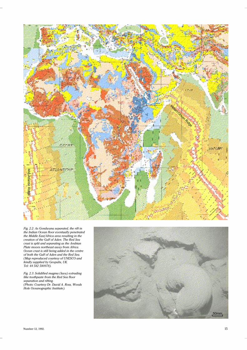
Fig. 2.2: As Gondwana separated, the rift in
the Indian Ocean floor eventually penetrated
the Middle East/Africa area resulting in the
creation of the Gulf of Aden. The Red Sea
crust is split and separating as the Arabian
Plate moves northeast away from Africa.
Ocean crust is still being added in the centre
of both the Gulf of Aden and the Red Sea.
(Map reproduced courtesy of UNESCO and
kindly supplied by Geopubs, UK.
Tel: 44 582 580978).
Fig. 2.3: Solidified magma (lava) extruding
like toothpaste from the Red Sea floor
separation and rifting.
(Photo: Courtesy Dr. David A. Ross, Woods
Hole Oceanographic Institute).
Indian Ocean Ridge
Mid-A
tlantic Ridge
50mm

CYAN MAGENTA YELLOW BLACK
16 Middle East Well Evaluation Review
Shear recyclings
Fault analysis in the Marib-Shabwa
region shows that the direction of the
failed arm, which led to the creation of
the Marib-Shabwa Basin around 160M
years ago, was dictated by large-scale
NW- SE and NE - SW shear faults that
began a billion years earlier, during the
Precambrian. The NE-SW lines of weak-
ness in the earth’s crust are termed the
Najd fault zones and can be seen cross-
ing Arabia and Africa. Unlike human
bones, these faults do not strengthen on
healing. They remain planes of weak-
ness in the earth’s crust.
When Gondwana split apart, the
crust in Yemen responded by stretch-
ing, fracturing and block-faulting along
one of these ancient fault zones. The
size of the graben that developed origi-
nally extended throughout Yemen and
may have reached as far as present-day
Somalia - more than twice the length of
the Gulf of Suez graben.
At this time, Yemen and Somalia
were connected and, for this reason,
there is no evidence of rifting in the pre-
sent-day Gulf of Aden. Exploration for
hydrocarbons in the Somalian portion
of the graben has only just begun.
Since oil was first discovered in
Jurassic sandstones at Alif Field in 1984,
11 commercial discoveries have been
made in Yemen in the Marib-Shabwa
graben by YHOC and others. The explo-
ration drilling has revealed that each of
the sub-basins defined by geophysical
means (gravity, magnetics and seismic)
was filled by various types and
sequences of sediments, resulting in dif-
ferent reservoir types. The Marib sub-
basin is a complex mixture of
interfingering sandstones, evaporites
and shales with the sandstone reser-
voirs being dominant. In contrast, the
Iyad sub-basin is dominated by carbon-
ate reservoir zones. There are only
very minor sandstones within the rift
sequence and a thin Kolhan Formation
sandstone reservoir of a pre-rift origin.
The Shabwa sub-basin has one
major sandstone reservoir unit and has
shown little carbonate reservoir poten-
tial. The southernmost sub-basin, the
Borlaf, is slightly younger than the
Marib-Shabwa graben as are the
grabens which developed further east.
They have no Jurassic salt but are filled
by Cretaceous clastics with minor car-
bonate intervals. The south-eastern-
most sub-basin has a prospective
Jurassic section including thick salts
but no commercial oil has yet been
found.
Fig. 2.4: Testing the Alif 1 well. (Photo: YHOC).
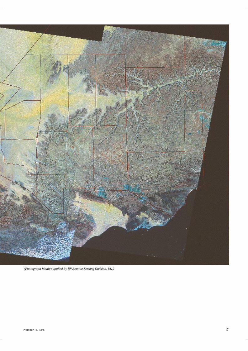
Fig. 2.5: MARIB MAGNIFIED: Most of Yemen’s treasure trove of oil has been found in the Marib-
Shabwa Graben. This LANDSAT photograph shows the location of the major fields.The Alif Field
reserves are estimated at 500 million barrels. Alif 1 discovery well flowed from two separate
zones at rates of 3,669B/D (40.4° API) and 4,162B/D (39.8°API) with 55 million ft3/day of natural
gas. Asa'ad Al Kamil Field, which was discovered in 1988, is the second largest sandstone
producer in Yemen and lies some 15km northeast of Alif Field. The field has recoverable reserves
of about 140 million barrels of oil and 2.7 trillion ft3 of gas and covers an area of 60km2. Azal
Field is a subsidiary structure of the Alif Field. It was declared commercial on April 15th 1987 after
the discovery well produced 5,400B/D (39°API). The field is 9km long and 5km wide. YHOC has
also discovered many other sandstone fields in the Marib Basin including Saif, Jabal Nuqum,
Raydan, Al Wihdah, Al Shura, Al-Raja and Dostur Al-Wihdah.
17Number 12, 1992.
(Photograph kindly supplied by BP Remote Sensing Division, UK.)
CYAN MAGENTA YELLOW BLACK
18 Middle East Well Evaluation Review
Treasure hunt
When Yemen Hunt's Alif 1 well was
tested at a combined rate of 7831 BOPD
(40.4°API) in July 1984 it sparked off
intense industry interest in a previous-
ly ignored part of the Arabian Peninsu-
la. As development of the Alif Field and
exploration continued, it became clear
that a new stratigraphic framework was
required.
The sedimentary section within the
basin is, for the most part, unlike any-
thing else seen in the Jurassic of the
Arabian Peninsula, and much of the
basin-fill is not seen in outcrop. YHOC
and it’s partners, Exxon and Yukong,
have now drilled over 300 wells within
the basin, and these have provided the
information and control for the con-
struction of a stratigraphic nomencla-
ture. Many of the formations are
present only in the subsurface and thus
are named after wells, whereas others
are named for surface features or out-
crops.
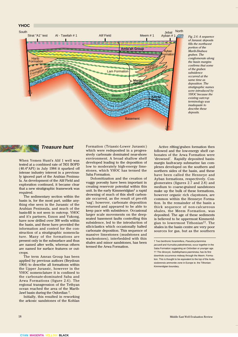
The term Amran Group has been
applied by previous authors (Beydoun
1964) to describe all formations within
the Upper Jurassic, however in the
YHOC nomenclature it is confined to
the carbonate-dominated Saba and
Arwa Formations (figure 2.6). The
regional transgression of the Tethyan
ocean reached the area of the Marib-
Jawf basin during the Oxfordian †.
Initially, this resulted in reworking
the arkosic sandstones of the Kohlan
Formation (Triassic-Lower Jurassic)
which were redeposited in a progres-
sively carbonate dominated near-shore
environment. A broad shallow shelf
developed leading to the deposition of
low to moderately high-energy lime-
stones, which YHOC has termed the
Saba Formation.
Dolomitization and the creation of
vuggy porosity have been important in
creating reservoir potential within this
unit. In the early Kimmeridgian† a rapid
drowning of much of this shelf carbon-
ate occurred, as the result of pre-rift
‘sag’; however, carbonate deposition
returned and appeared to be able to
keep pace with subsidence. Occasional
larger scale movements on the deep-
seated basement faults controlling this
subsidence, led to the introduction of
siliciclastics which occasionally halted
carbonate deposition. This sequence of
massive limestones (mudstones and
wackestones), interbedded with thin
shales and minor sandstones, has been
termed the Arwa Formation.
Active rifting/graben formation then
followed and the low-energy shelf car-
bonates of the Arwa Formation were
‘drowned’. Rapidly deposited basin-
margin fault-scarp submarine fan com-
plexes developed on the southern and
northern sides of the basin, and these
have been called the Henneye and
Ayban formations, respectively. Con-
glomerates (figures 2.7 and 2.8) and
medium to coarse-grained sandstones
make up the bulk of these formations,
however organic rich claystones, are
common within the Henneye Forma-
tion. In the remainder of the basin a
thick sequence of non-calcareous
shales, the Meem Formation, was
deposited. The age of these sediments
is believed to be uppermost Kimmerid-
gian to lowermost Tithonian††. The
shales in the basin centre are very poor
sources for gas, but as the southern
† Two benthonic foraminifera, Pseudocyclammina
jaccardi and Kurnubia palestiniensis, occur together in the
Saba Formation suggesting an Oxfordian or younger age.
†† The dinocyst, Subtilisphaera paeminosa, has its first
downhole occurrence midway through the Meem. Forma-
tion. This is thought to be equivalent to the top of the Autis-
siodorensis ammonite zone in Europe ie. the Tithonian-
Kimmeridgian boundary.
Fig. 2.6: A sequence
of Jurassic deposits
fills the northwest
portion of the
Marib-Shabwa
graben. The
conglomerate along
the basin margins
confirms that some
of the graben
subsidence
occurred at the
same time as
deposition. The
stratigraphic names
were introduced by
YHOC because the
existing outcrop
terminology was
inadequate to
describe these
deposits.
YHOC
Raydan
Amla’ah Group
Lam Formation
Harib Formation
Henneye
Formation
Saba Formation
Saba FormationArwa Formation
Meem Formation
South NorthStrat "A1" test Al - Tawilah # 1 Meem # 1
Jebal Ayban # 1Alif Field
Formation
Ayban Formation
Basement
Marib Group
Amran Group
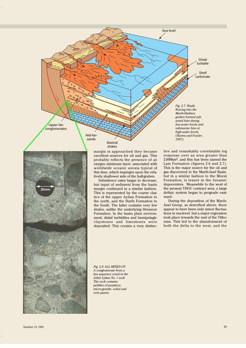
Sea level
Distal turbidite
Shelf carbonate
Basinal shales
Mid-fan sands
Upper-fan conglomerates
19Number 12, 1992.
margin is approached they became
excellent sources for oil and gas. This
probably reflects the presence of an
oxygen minimum layer, associated with
worldwide oceanic anoxia typical of
this time, which impinges upon the rela-
tively shallower side of the half-graben.
Subsidence rates began to decrease,
but input of sediment from the basin
margin continued in a similar fashion.
This is represented by the coarse clas-
tics of the upper Ayban Formation to
the north, and the Harib Formation to
the South. The latter contains very few
shales, unlike the underlying Henneye
Formation. In the basin plain environ-
ment, distal turbidites and hemipelagic
claystones and limestones were
deposited. This creates a very distinc-
tive and remarkably correlatable log
response over an area greater than
2,000km2, and this has been named the
Lam Formation (figures 2.6 and 2.7).
This is the major source for the oil and
gas discovered in the Marib-Jawf Basin,
but in a similar fashion to the Meem
Formation, is leaner in the Jurassic
depocenters. Meanwhile to the west of
the present YHOC contract area, a large
deltaic system began to prograde east-
ward.
During the deposition of the Marib-
Jawf Group, as described above, there
appear to have been only minor fluctua-
tions in sea-level, but a major regression
took place towards the end of the Titho-
nian. This led to the abandonment of
both the delta to the west, and the
Fig. 2.7: Wadis
flowing into the
Marib-Shabwa
graben formed sub-
aerial fans during
low-water levels and
submarine fans at
high-water levels.
(Harms and Fowler,
1987).
Fig. 2.8: ALL MIXED UP:
A conglomerate from a
fan sequence cored in the
Jebal Ayban No. 1 well.
The rock contains
pebbles of porphyry,
micro-granite, schist and
vein quartz.
30mm
CYAN MAGENTA YELLOW BLACK
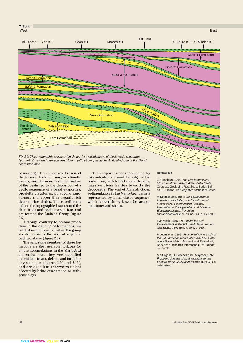
The evaporites are represented by
thin anhydrites toward the edge of the
post-rift sag, which thicken and become
massive clean halites towards the
depocentre. The end of Amla’ah Group
sedimentation in the Marib-Jawf basin is
represented by a final clastic sequence,
which is overlain by Lower Cretaceous
limestones and shales.
West East
Al-Shura # 1 Al-Wihdah # 1 Alif Field
Ma'een # 1 Sean # 1 Yah # 1 Al-Tahreer
Safer 1 Formation
Safer 2 Formation
Safer 3 Formation Safer 4 Formation
Safer 5 Formation
Alif Formation Sean Formation
Yah Formation Pro-delta shales
Lam Formation
basin-margin fan complexes. Erosion of
the former, tectonic, and/or climatic
events, and the none restricted nature
of the basin led to the deposition of a
cyclic sequence of a basal evaporites,
pro-delta claystones, polycyclic sand-
stones, and upper thin organic-rich
deep-marine shales. These sediments
infilled the topographic lows around the
delta front and basin-margin fans and
are termed the Amla’ah Group (figure
2.6).
Although contrary to normal proce-
dure in the defining of formations, we
felt that each formation within the group
should consist of the vertical sequence
outlined above (figure 2.9).
The sandstone members of these for-
mations are the reservoir horizons for
all the accumulations in the Marib-Jawf
concession area. They were deposited
in braided stream, deltaic, and turbiditic
environments (figures 2.10 and 2.11),
and are excellent reservoirs unless
affected by halite cementation or authi-
genic clays.
References
ZR Beydoun, 1964: The Stratigraphy andStructure of the Eastern Aden Protectorate,Overseas Geol. Min. Res. Supp. Series,Bull. no. 5, London, Her Majesty’s Stationery Office.
M Septfontaine, 1981: Les ForaminiferesImperfores des Milieux de Plate-forme alMesozoique: Determination Pratique,Interpretation Phyllogenetique, et UtilisationBiostratigraphique, Revue deMicropaleontologie, v. 23, no. 3/4, p. 169-203.
I Maycock, 1986: Oil Exploration andDevelopment in Marib/Al Jawf Basin, Yemen(abstract); AAPG Bull. v. 70/7, p. 930.
P Lucas et al, 1988: Sedimentological Study ofthe Alif Formation for the Alif Field, Azal Field,and Wildcat Wells, Ma’een-1 and Sean-Ba-1,Robertson Research International Ltd, Reportno. D-038.
M Sturgess, JG Mitchell and I Maycock,1992:Proposed Jurassic Lithostratigraphy for theEastern Marib-Jawf Basin, Yemen Hunt Oil Copublication.
Fig. 2.9: This stratigraphic cross section shows the cyclical nature of the Jurassic evaporites
(purple), shales, and reservoir sandstones (yellow) comprising the Amla'ah Group in the YHOC
concession area.
YHOC
Middle East Well Evaluation Review20
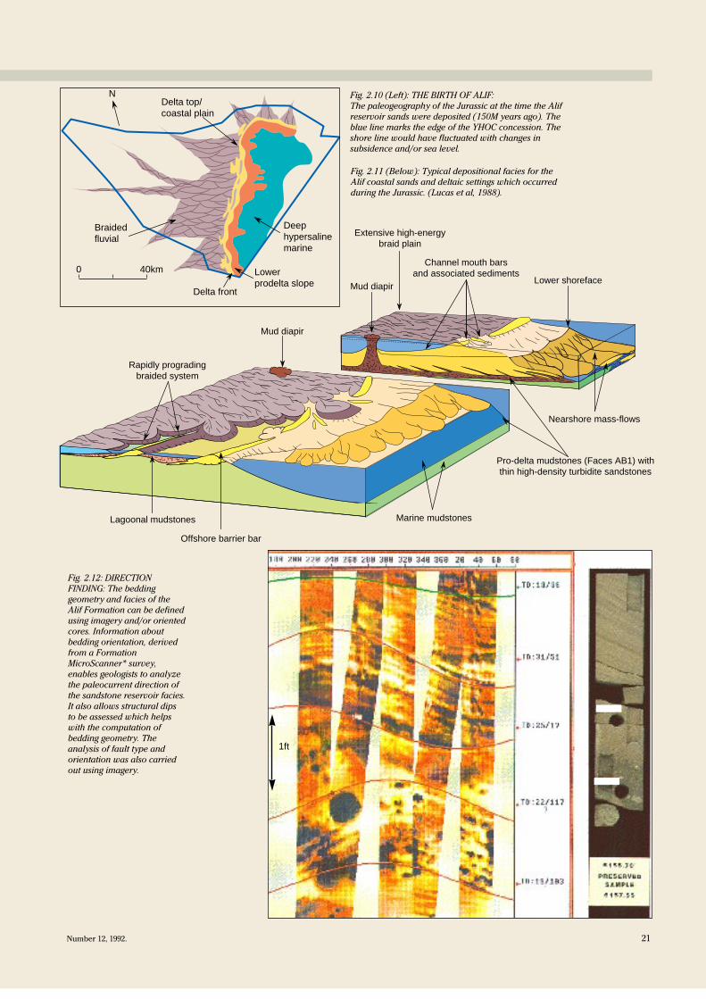
Channel mouth bars and associated sediments
Lower shoreface
Extensive high-energy braid plain
Mud diapir
Nearshore mass-flows
Marine mudstones
Pro-delta mudstones (Faces AB1) with thin high-density turbidite sandstones
Offshore barrier bar
Lagoonal mudstones
Rapidly prograding braided system
Mud diapir
Fig. 2.10 (Left): THE BIRTH OF ALIF:
The paleogeography of the Jurassic at the time the Alif
reservoir sands were deposited (150M years ago). The
blue line marks the edge of the YHOC concession. The
shore line would have fluctuated with changes in
subsidence and/or sea level.
Fig. 2.11 (Below): Typical depositional facies for the
Alif coastal sands and deltaic settings which occurred
during the Jurassic. (Lucas et al, 1988).
Fig. 2.12: DIRECTION
FINDING: The bedding
geometry and facies of the
Alif Formation can be defined
using imagery and/or oriented
cores. Information about
bedding orientation, derived
from a Formation
MicroScanner* survey,
enables geologists to analyze
the paleocurrent direction of
the sandstone reservoir facies.
It also allows structural dips
to be assessed which helps
with the computation of
bedding geometry. The
analysis of fault type and
orientation was also carried
out using imagery.
1ft
Delta top/ coastal plain
0 40km
Braided fluvial
Deep hypersaline marine
Lower prodelta slope
Delta front
N
21Number 12, 1992.
CYAN MAGENTA YELLOW BLACK
22 Middle East Well Evaluation Review
Six gems in the Jurassic
Six carbonate fields have been discov-
ered in the Iyad sub-basin of the Marib-
Shabwa graben which lies southeast of
the YHOC sandstone discoveries. The
fields are West, East and Central Iyad,
Amal, Magraf and Al-Gor. Four other
structures were drilled by Technoex-
port but they were found to be dry. Its
concession block was later acquired by
Nimr Petroleum Company†††.
The fields are producing from a num-
ber of Jurassic carbonate intervals with
minor zones found in thin sandy zones
and the fractured basement. Technoex-
port estimates the fields contain more
than 3 billion barrels. Most of the crude
is 41-43°API with low sulphur content.
The remainder is 36°API with higher
sulphur content (in a separate horizon)
which may be associated with a gas
cap. Reserves of natural gas are estimat-
ed at about 15 trillion cubic feet.
Whether this much oil and gas will be
recovered is now in doubt as the reser-
voir pressures have declined rapidly.
Faulting and the lenticular nature of
some of the carbonate and sandy zones
has created small compartments in the
reservoirs. The rapid decrease in reser-
voir pressure in some zones is probably
caused by faulting or zoning .
The lithology of the reservoir zones
includes both limestones and dolomites
with a wide variety of pore types
including interparticle, intercrystalline,
vugs, moulds and fractures.
The depositional origin of the car-
bonate reservoirs includes reefal mate-
rial and grainstones. However, much of
the sequence appears to be of deep-
water origin and was probably deposit-
ed after the drowning of the basin.
Shoals and banks appear to have devel-
oped on the apex of the underlying
structure.
††† Arco Shabwa Inc, a local subsidiary of ARCO
International Oil and Gas Company, is supplying
Nimr Petroleum Company with exploration and pro-
duction services on the 1,930km2
Block 4 which con-
tains the Amal and Iyad fields.
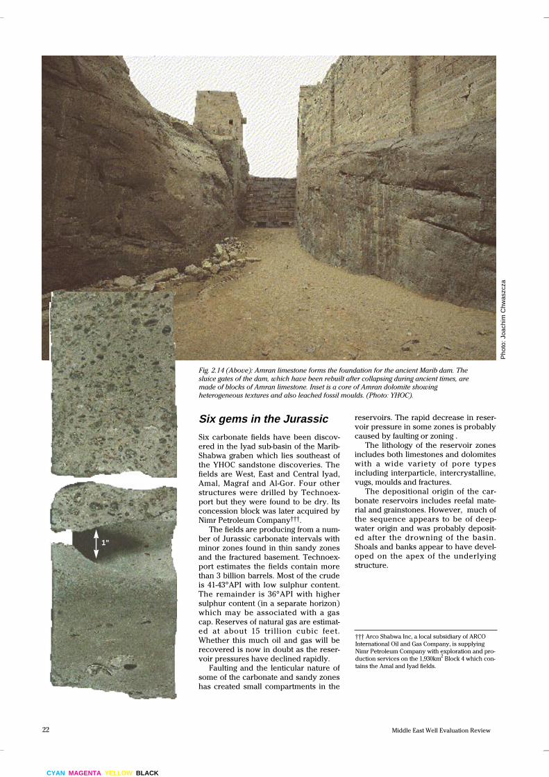
Fig. 2.14 (Above): Amran limestone forms the foundation for the ancient Marib dam. The
sluice gates of the dam, which have been rebuilt after collapsing during ancient times, are
made of blocks of Amran limestone. Inset is a core of Amran dolomite showing
heterogeneous textures and also leached fossil moulds. (Photo: YHOC).
Pho
to: J
oach
im C
hwas
zcza
1"
23Number 12, 1992.
������������������
�������������
? ? ?Naifa Fm
Am
ran
Gro
up
Upper Amran Group
?
Amala'ah Group
Lower Amran Group
Kohlan Fm
Basement (fractured)
SW NE
Shelf margin (outcropping) Iyad sub-basinUnder Old Marib dam
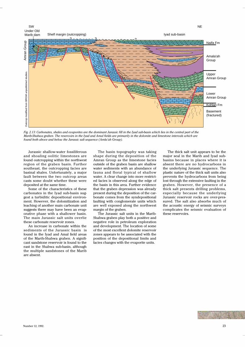
Jurassic shallow-water fossiliferous
and shoaling oolitic limestones are
found outcropping within the northwest
region of the graben basin. Further
southeast, the outcropping facies are
basinal shales. Unfortunately, a major
fault between the two outcrop areas
casts some doubt whether these were
deposited at the same time.
Some of the characteristics of these
carbonates in the Iyad sub-basin sug-
gest a turbiditic depositional environ-
ment. However, the dolomitization and
leaching of another main carbonate unit
suggests there may have been an evap-
orative phase with a shallower basin.
The main Jurassic salt units overlie
these carbonate reservoir zones.
An increase in carbonate within the
sediments of the Jurassic basin is
found in the Iyad and Amal field areas
of the Marib-Shabwa graben. A signifi-
cant sandstone reservoir is found to the
east in the Shabwa sub-basin, although
the multiple sandstones of the Marib
are absent.
The basin topography was taking
shape during the deposition of the
Amran Group as the limestone facies
outside of the graben basin are shallow
water sediments with an abundance of
fauna and floral typical of shallow
water. A clear change into more restrict-
ed facies is observed along the edge of
the basin in this area. Further evidence
that the graben depression was already
present during the deposition of the car-
bonate comes from the syndepositional
faulting with conglomerate units which
are well exposed along the northwest
margin of the graben.
The Jurassic salt units in the Marib-
Shabwa graben play both a positive and
negative role in petroleum exploration
and development. The location of some
of the most excellent dolomite reservoir
zones appears to be associated with the
position of the depositional limits and
facies changes with the evaporite units.
Fig. 2.13: Carbonates, shales and evaporites are the dominant Jurassic fill in the Iyad sub-basin which lies in the central part of the
Marib-Shabwa graben. The reservoirs in the Iyad and Amal fields are primarily in the dolomite and limestone intervals which are
found both above and below the Jurassic salt sequence (Amla’ah Group).
The thick salt unit appears to be the
major seal in the Marib and Iyad sub-
basins because in places where it is
absent there are no hydrocarbons in
the underlying Jurassic sequence. The
plastic nature of the thick salt units also
prevents the hydrocarbons from being
lost through the extensive faulting in the
graben. However, the presence of a
thick salt presents drilling problems,
especially because the underlying
Jurassic reservoir rocks are over-pres-
sured. The salt also absorbs much of
the acoustic energy of seismic surveys
complicates the seismic evaluation of
these reservoirs.
Out
crop
mod
ified
from
BR
GM
unpu
blis
hed
stud
ies.
CYAN MAGENTA YELLOW BLACK
24 Middle East Well Evaluation Review
Pickled pores
This salt precipitation in Alif sandstone
reservoirs was probably due to the
reduction in pressure and temperature
during production. Such problems were
encountered in the Azal Field where
they were thought to be associated with
coning of supersaturated aquifer waters
below the thin oil column.
Core analysis shows that 50%-70% of
the reservoir pores, or 10%-15% of the
bulk volume, are filled with halite. In
some cases, the salt cementation is
patchy but, in others, discrete layers
can be seen. Some of the salt contained
within the sandstones was present
shortly after deposition. However, some
of the halite precipitated much later,
after the sand had compacted but
before the oil was in place. The halite,
removed by methanol flushing, restored
the porosity of the oil zone to 16%-18%.
The amount of halite salt cement in
the sandstone can be determined from
Thermal Decay Time (TDT*) tool mea-
surements. Figure 2.18 shows a TDT log
from an interval of Alif sandstones. This
was integrated with other openhole
logs, using the Elemental Analysis
(ELAN*) approach to formation analy-
sis, to deduce the amount of salt in the
rock pores.
The chlorine atoms react to the neu-
trons emitted by the TDT tool and give
off gamma rays which in turn are mea-
sured by the sensors in the TDT tool.
Although normally logged in cased
hole, for this application the TDT is run
in open hole.
The effect of halite on the standard
logging measurements suggests a low-
density mineral. However, it is not pos-
sible to evaluate its volume
quantitatively. A scanning electron
microscope (SEM) view of a core sam-
ple in which halite cement fills much of
the pore spaces is shown in figure 2.18.
The 15pu-20pu of halite in the reser-
voir sandstone is shown in the ELAN
presentation (figure 2.18). When the for-
mation capture cross section is high,
such as in a halite layer, the TDT sigma
value is unrepresentative of the true for-
mation sigma. But in halite-cemented
sands, the measurement is reliable
because the sigma formation value
remains below the borehole sigma
value.
In the Alif sandstones, a theoretical
sigma value of 750cu has been used for
halite interpretation. Using this
approach, the original porosity, which
equals the measured porosity plus the
volume of halite in the rock, remains
fairly constant between 15pu and 20pu
in the clean section of top sand. This
suggests that the halite was introduced
into the sandstone before burial com-
paction and other diagenesis had
occurred. In essence, the reservoir was
pickled.
The Jurassic salt appears at the sur-
face in seven salt domes (three in the
Mintaq area at the southern end of the
basin; three in the Shabwa central area
and one at Safer).
The exploration potential of the
entire basin is confirmed by the
petroleum occurrences at each of these
salt domes. The basin continues
towards the southeast and has a thicker
but younger sedimentary sequence
near the Balhaf area, close to the Gulf of
Aden.
Fig. 2.16: Central portion of an exposed salt dome with Amla’ah Group salt which outcrops
within the YHOC concession area.
Fig. 2.17: The Jurassic to
modern volcanics found
within the Marib-Shabwa
graben were once considered
a negative factor for oil
exploration in this basin.
YH
OC
Joac
him
Chw
aszc
za
25Number 12, 1992.
Fig. 2.18: Sodium and chlorine atoms
combine to make a very simple cubic
molecular structure which is the
mineral halite, more commonly
called ‘table salt’’. It is the chlorine
which absorbs the neutron particles
emitted by a TDT tool. They in turn
give off gamma-ray radiation which is
measured by the TDT tool. The
volume of chlorine defined is used in
the determination of the halite
volume shown in the Elemental
Analysis (ELAN*) log. The SEM
photograph (top) shows halite
crystals which have grown within the
pore space between the sand grains.
Neutron burst from TDT tool excites halitesin rock. Gamma rays are given off.
SE
M fr
om C
hevr
on/A
AP
G
500x magnification
Chlorine atoms in the salt molecule giveoff gamma rays when excited by theTDT tool’s neutron burst.
One of the halite crystals is shown inmauve to indicate that it has beenexcited and is giving off gamma rays.
100f
t
CYAN MAGENTA YELLOW BLACK
26 Middle East Well Evaluation Review
Searching for clues
Other grabens, which have a similar
trend, may extend from Saudi Arabia
into Yemen. The direction of the Qamar
trough, which lies in southeast Yemen,
may have been influenced by the
regional shear faults and, as yet, the oil
potential of this trough has not been
adequately tested.
Connie Andre of the Smithsonian
Institute has shown that the Najd fault
system was reactivated and extended
southeast during the Mesozoic and
Cenozoic†. It is possible that more
grabens formed, producing similar sedi-
mentary basins to the Marib Basin.
This is also supported by remote
sensing data (spot stereoscopic, The-
matic Mapper (TM) multispectral
images, Thermal Infra-red images and
Advanced Very High Resolution
Radiometer data). These have revealed
a major shear zone to the southeast of
the Najd fault zone in Arabia. The total
length of the visible fault system is over
1,300km but it is possible that a younger
extension of the Najd system extends
beneath the sands of the Empty Quar-
ter, across the Rub-al-Khali desert. Seis-
mic data also indicates that the Najd
fault complex extends under the sands
of the Empty Quarter. This may even
connect with similar faults we can see
in southwest Yemen. The recent Elf
well in northeast Yemen may shed
more light on the details of this relative-
ly unexplored region.
The direction of movement along
these faults is left (sinistral) lateral and
offsets up to 2.5km are visible. If the
faults extend beneath the desert sands,
more reservoirs may be found. En eche-
lon folds and secondary faulting may
have occurred, creating hydrocarbon
traps in the Paleozoic sandstones or
Jurassic sandstones and carbonates.
The tectonic movements associated
with the Najd extensions have probably
led to the juxtaposition of Infracambrian
Ghaber Group source rocks with
younger, more porous, reservoir hori-
zons. The Ghaber Group also includes
limestones, dolostones and sandstones
which have been shown by Ziad Bey-
doun to correlate with the oil-produc-
tive Huqf Group lying to the east, in
Oman’s Dhofar region. Yemen’s algal-
rich Infracambrian carbonates are iden-
tical to those producing in Oman.
However, there is no information to
confirm that the Yemeni carbonates
have the same sealing salts as those in
the Huqf Field.
Fig.2.19: ARMCHAIR EXPLORATION: This computer-generated LANDSAT false-colour composite
image of Yemen was acquired using the Thematic Mapper sensor. The image covers an area of
185km by 178km with a ground cell resolution of 28.5m by 28.5m. The LANDSAT satellite orbits
the earth at an altitude of 700km and produces images using
two visible and one reflected infra-red spectral bands. This image has been used to map structural
features such as anticlines, synclines, faults and fractures as well as general photogeologic
stratigraphic units.
†C. Andre, 1989: Photogram Eng. Remote
Sensing, v. 55, no. 8, p 1129-1136.
27Number 12, 1992.
In addition, special processing of the LANDSAT data (see insert) has revealed areas which may indicate the presence of hydrocarbons near or
at the surface. Several promising areas were detected from the images and the prospects were subsequently upgraded after hydrocarbons were
detected. The satellite information also provides a ‘road map’ for seismic surveying, site development, environmental benchmarking and
environmental monitoring. In general, LANDSAT data provides vast amounts of geological and environmental information in a short time and at
low cost. (Image kindly provided by Texaco E & P Research Division, Houston, Texas, USA).
Sunah Field
Hemiar Field
Camaal Field
Heijahl Field
CYAN MAGENTA YELLOW BLACK
28 Middle East Well Evaluation Review
Are there more Maribs?
Canadian Occidental’s four oil discover-
ies (Sunah, Camaal, Heijah and Hemiar
fields) in anticlinal structures to the east
of the Marib basin are in Cretaceous
Qishn Formation sandstones. Canadi-
anOxy’s reserves are estimated to be
about 750 million barrels, based on the
discovery of Hemiar Field in 1992. This
field is located 18km east of Sunah
Field. The production is expected to
increase to 100,000B/D by the end of
1993.
In this area there are numerous pos-
sible structural traps, in the form of
faulted anticlines, along Yemen’s south
coast. Here, the continental shelf is very
narrow, averaging 20km-30km wide and
lies in about 1,000m of water. Wider sec-
tions of shelf occur in three main areas:
• West of Aden, opposite the mouths
of the Wadi Turban and Wadi Bana,
• In the Sayhut/Ras Sharwayn area,
• At Wadi Jeza.
The most promising horizons for
hydrocarbon exploration are found in
the Paleocene and Eocene-age lime-
stones. Evaporitic shales may be a
potential source rock and the persistent
Eocene Rus evaporite is probably a
good seal.
AGIP has carried out most of the
exploration in this region and has
drilled eight wells, all of which have oil
and/or gas shows. The most promising
is the Sharmah well which has been
tested in three different zones. Heavy
oil flowed from one zone but the
Oligocene Ghadyah Formation pro-
duced 300B/D of light oil (40.5°API).
The Eocene Habshiya Formation pro-
duced 1,800B/D but this flow rate was
almost doubled after acid treatment.
Even so, the field was considered non-
commercial.
Geochemical examination of oil from
the Habshiya and Cretaceous Harshiyat
Formations, undertaken by AGIP, sug-
gests that the Eocene oil was generated
by the Rus or Jeza formations or the
Paleozoic Radhuma Formation. Oil
recovered from Cretaceous formations
seems to have its source in rocks of the
same age.
An excellent oil-prone source rock
has been found in the Upper Creta-
ceous in thick deposits which were laid
down before the Gulf of Aden was creat-
ed. The high geothermal gradient in the
region indicates that any oil found in
the Gulf of Aden and environs will prob-
ably exist at shallow depths between
1,750m and 3,500m.
Studies of organic materials extract-
ed from offshore wells have shown that
oil buried below these depths would
eventually be cracked into methane.
This is why the Tima Basin in the Red
Sea is expected to contain gas reserves.
However, the decrease in the thermal
gradient throughout much of the Sayut
Basin in southeast Yemen means that
oil could still be present in these rocks.
The World Bank-financed Red Sea
and Gulf of Aden project recently sum-
marized Yemen’s offshore hydrocarbon
potential. It concluded that prospective
traps formed in the Gulf of Aden during
Early Oligocene rifting. Since then, sub-
sidence associated with sea-floor
spreading under the Gulf of Aden has
led to these traps becoming buried to a
depth as great as 2,000m - the same
depth as the estimated oil window.
Yemen’s Red Sea coastal shelf is
proving to be an attractive exploration
target. Not only does it have a relatively
wide graben shelf but it also has thick
salt deposits which could provide excel-
lent seals for underlying reservoir
rocks. In addition, organic matter asso-
ciated with the major marine evaporites
could provide an excellent hydrocar-
bon source.
Black, organic-rich shale deposits are
often found below the thick salt layers
in this region. These are usually
radioactive because uranium has accu-
mulated in the minerals associated with
organic matter. These pre-evaporitic
deposits vary in content and this dic-
tates the type of hydrocarbon they
would produce if brought to maturation.
Those with sapropelic (marine origin)
organic material yield oil while those of
humic origin will be gas prone.
Dark shales within these pre-evapor-
ites have been found in a number of
Tihama basin wells. Their total organic
carbon ranges in value between 1% and
2.9% and they are often interbedded
0 50km
x x x xx x x x
x x
CoastJ-1
MN-1C-1SF-1
Coastal basin Salt basin Salt wall
Thio-1Amber-1
Dhunishub B-1
+
+
++
+
+
+
++
+++
++
+++
++
++
++
+
+
++
++
+
+
+
++
++
+
+++
+
++
xx
SW
Miocene SaltOcean crust
Redbeds-Lavas-Evaporites
Rift Valley Erosion
Continental crust
Oceanic crust
Fig. 2.21 (Below): Cross section through
the southern end of the Red Sea. As the
crustal plates pull apart the pre-evaporite
reservoir carbonates and sands are
subjected to complex faulting and
folding. Thick Miocene salts provide an
excellent seal but they also hinder
seismic exploration.
Fig. 2.20: DON'T PANIC!: The continental crust in the Red Sea will
continue to pull apart and, in many millions of years, a large ocean will
exist between Arabia and Africa.
Modified from JCDoornenbal et al., 1991;Geology and HydrocarbonPotential of the TihamaBasin, Yemen: SPE MiddleEast Oil Show & E Savoyatet al., 1989; PetroleumExploration in the EthiopianRed Sea: Jour. Pet. Geol.,v. 12, no. 2.
29Number 12, 1992.
with the overlying Miocene evaporite
sequence. Shows of medium gravity oil
have also been found.
The extremely low radioactivity of
the overlying salt does not indicate a
change in environmental conditions. It
probably reflects the increased sedi-
mentation rate which occurs in hyper-
saline brines and dilutes the effect of
the organic accumulation which per-
sists at a high rate.
The thick salt layers of Miocene
evaporite which overlie the known
organic source rock units are attractive
features for explorationists. However,
the salt layers act as a low-velocity fil-
ter, hampering investigation of these
rocks using surface seismic studies.
Crustal rifting in the central part of
the Red Sea, combined with the cre-
ation of new sea floor, has split the orig-
inal evaporites and pre-evaporites.
There are now two evaporite
sequences running parallel to each
other on each side of today’s Red Sea
rift basin.
Western fringe basin
Axial trough
Central part of the salt basin
Salt basin axis Coast
Eastern fringe basin Mountain
escarpment
++
+ ++
+++
++
++
+ ++
++ +
++
++
+
++
+++ +
+++
++
+
++
++
+
NE
+
Miocene SaltContinental crust
The burial of the thick salt deposits
is accompanied by flowage and doming
of the salt which adopts a low-density
and plastic nature under pressure. This
salt flow is often the most important
hydrocarbon trapping sequence in post-
evaporite deposits but it does make
investigation of deeper structures more
difficult. Unfortunately, the Miocene salt
sequence has resulted in irregular
depositional geometry and erratic distri-
bution of post-evaporite deposits. In
onshore wells, clastics dominate this
sequence but, further offshore, carbon-
ate zones become increasingly impor-
tant.
km
0
1
2
3
4
5
Hathout 1 Taur 2 Al Fatk 1X Sharmah 1
Gulf of AdenJesa Basin
N. Hadramaut high
Rub Al Khali
��Upper Tertiary
Upper Cretaceous
Jurassic Limestone
����
�������������������
���� � ���
������
������
Sunah 1
Sunah 2
Kohlan ss reservoir
Qishn ss
Sandstone (L. Cretaceous Qishn & Jurassic Kohlan)
Lower Tertiary
Lower Cretaceous
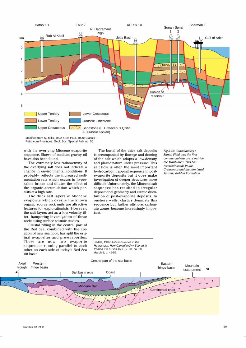
S Mills, 1992: Oil Discoveries in theHadramaut: How CanadianOxy Scored inYemen, Oil & Gas Jour., v. 90, no. 10,March 9, p. 49-52.
Fig.2.22: CanadianOxy’s
Sunah Field was the first
commercial discovery outside
the Marib area. This has
reservoir sands in the
Cretaceous and the thin basal
Jurassic Kohlan Formation.
Modified from SJ Mills, 1992 & SK Paul, 1990: ClassicPetroleum Provinces: Geol. Soc. Special Pub. no. 50.