los angeles to san diego via inland empire angeles to san diego via inland empire california...
TRANSCRIPT
Program Environmental Impact Report/Environmental Impact Statement
CALIFORNIA HIGH-SPEED TRAIN
Prepared for:
California High-Speed Rail Authority
U.S. Department of Transportation Federal Railroad Administration
U.S. Departmentof TransportationFederal RailroadAdministration
Los Angeles to San Diego via Inland Empire
Traffic, Transit, Circulation, and Parking
Technical Evaluation
January 2004
CALIFORNIA HIGH-SPEED TRAIN PROGRAM EIR/EIS
Task 2.4
Los Angeles to San Diego via
Inland Empire
Traffic, Transit, Circulation and Parking
Technical Evaluation
Prepared by:
in association with
JANUARY 2004
Los Angeles to San Diego via Inland Empire California High-Speed Train Program EIR/EIS Traffic, Transit, Circulation and Parking Technical Evaluation
Page i
U.S. Departmentof TransportationFederal RailroadAdministration
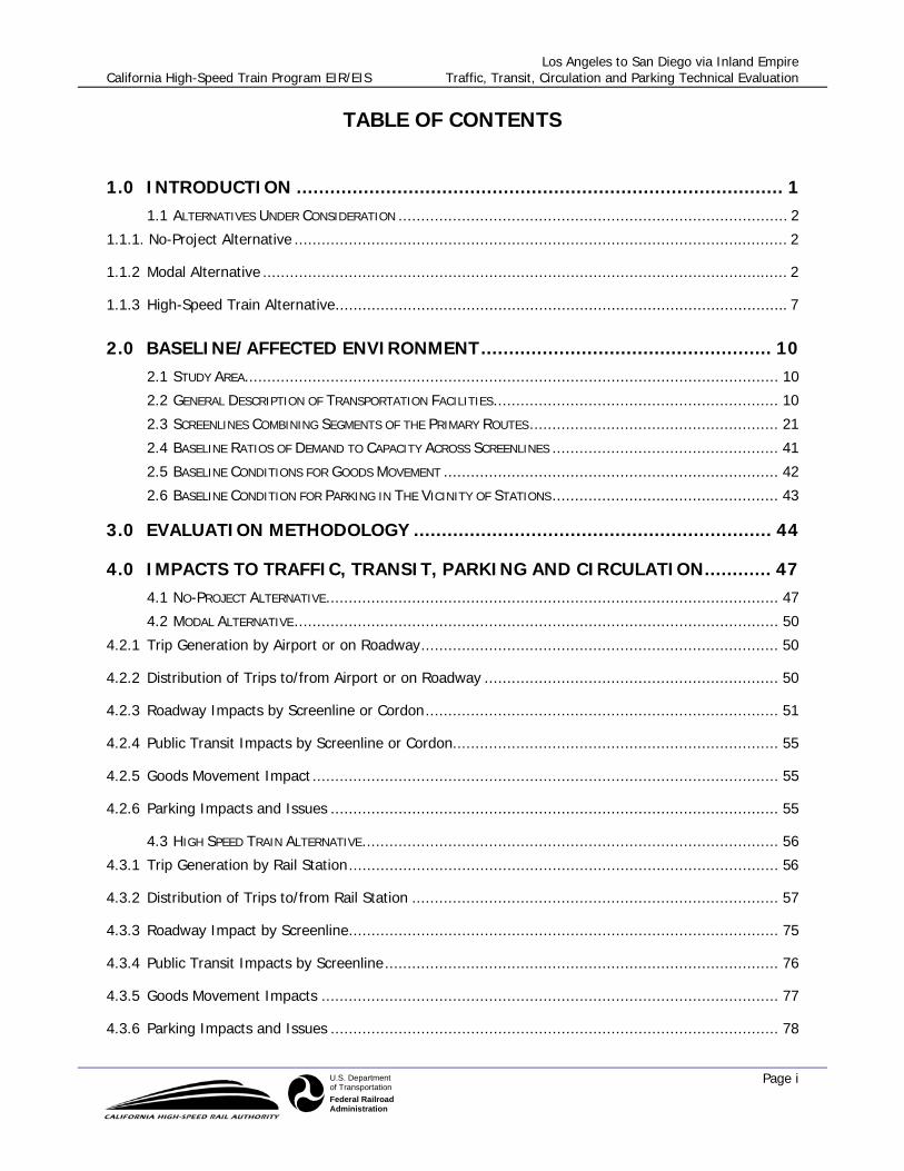
TABLE OF CONTENTS
1.0 INTRODUCTION ....................................................................................... 1 1.1 ALTERNATIVES UNDER CONSIDERATION ...................................................................................... 2
1.1.1. No-Project Alternative ............................................................................................................. 2
1.1.2 Modal Alternative .................................................................................................................... 2
1.1.3 High-Speed Train Alternative.................................................................................................... 7
2.0 BASELINE/AFFECTED ENVIRONMENT.................................................... 10 2.1 STUDY AREA...................................................................................................................... 10 2.2 GENERAL DESCRIPTION OF TRANSPORTATION FACILITIES............................................................... 10 2.3 SCREENLINES COMBINING SEGMENTS OF THE PRIMARY ROUTES....................................................... 21 2.4 BASELINE RATIOS OF DEMAND TO CAPACITY ACROSS SCREENLINES .................................................. 41 2.5 BASELINE CONDITIONS FOR GOODS MOVEMENT .......................................................................... 42 2.6 BASELINE CONDITION FOR PARKING IN THE VICINITY OF STATIONS.................................................. 43
3.0 EVALUATION METHODOLOGY ................................................................ 44
4.0 IMPACTS TO TRAFFIC, TRANSIT, PARKING AND CIRCULATION............ 47 4.1 NO-PROJECT ALTERNATIVE.................................................................................................... 47 4.2 MODAL ALTERNATIVE........................................................................................................... 50
4.2.1 Trip Generation by Airport or on Roadway............................................................................... 50
4.2.2 Distribution of Trips to/from Airport or on Roadway ................................................................. 50
4.2.3 Roadway Impacts by Screenline or Cordon.............................................................................. 51
4.2.4 Public Transit Impacts by Screenline or Cordon........................................................................ 55
4.2.5 Goods Movement Impact ....................................................................................................... 55
4.2.6 Parking Impacts and Issues ................................................................................................... 55
4.3 HIGH SPEED TRAIN ALTERNATIVE............................................................................................ 56 4.3.1 Trip Generation by Rail Station............................................................................................... 56
4.3.2 Distribution of Trips to/from Rail Station ................................................................................. 57
4.3.3 Roadway Impact by Screenline............................................................................................... 75
4.3.4 Public Transit Impacts by Screenline....................................................................................... 76
4.3.5 Goods Movement Impacts ..................................................................................................... 77
4.3.6 Parking Impacts and Issues ................................................................................................... 78

Los Angeles to San Diego via Inland Empire California High-Speed Train Program EIR/EIS Traffic, Transit, Circulation and Parking Technical Evaluation
Page ii
U.S. Departmentof TransportationFederal RailroadAdministration
5.0 REFERENCES .......................................................................................... 80
6.0 PREPARERS ............................................................................................ 81 6.1 HNTB CORPORATION .......................................................................................................... 81 6.2 CH2M HILL ..................................................................................................................... 81 6.3 MEYER MOHADDES AND ASSOCIATES............................................................................... 81 6.4 LINSCOTT, LAW AND GREENSPAN .................................................................................... 82
Los Angeles to San Diego via Inland Empire California High-Speed Train Program EIR/EIS Traffic, Transit, Circulation and Parking Technical Evaluation
Page iii
U.S. Departmentof TransportationFederal RailroadAdministration
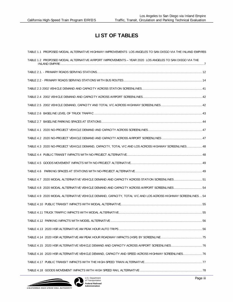
LIST OF TABLES
TABLE 1.1 PROPOSED MODAL ALTERNATIVE HIGHWAY IMPROVEMENTS LOS ANGELES TO SAN DIEGO VIA THE INLAND EMPIRE6
TABLE 1.2 PROPOSED MODAL ALTERNATIVE AIRPORT IMPROVEMENTS – YEAR 2020 LOS ANGELES TO SAN DIEGO VIA THE INLAND EMPIRE .............................................................................................................................................................7
TABLE 2.1. - PRIMARY ROADS SERVING STATIONS...................................................................................................................12
TABLE 2.2 - PRIMARY ROADS SERVING STATIONS WITH BUS ROUTES......................................................................................14
TABLE 2.3 2002 VEHICLE DEMAND AND CAPACITY ACROSS STATION SCREENLINES..................................................................41
TABLE 2.4 2002 VEHICLE DEMAND AND CAPACITY ACROSS AIRPORT SCREENLINES.................................................................42
TABLE 2.5 2002 VEHICLE DEMAND, CAPACITY AND TOTAL V/C ACROSS HIGHWAY SCREENLINES .............................................42
TABLE 2.6 BASELINE LEVEL OF TRUCK TRAFFIC ......................................................................................................................43
TABLE 2.7 BASELINE PARKING SPACES AT STATIONS ..............................................................................................................44
TABLE 4.1 2020 NO-PROJECT VEHICLE DEMAND AND CAPACITY ACROSS SCREENLINES ...........................................................47
TABLE 4.2 2020 NO-PROJECT VEHICLE DEMAND AND CAPACITY ACROSS AIRPORT SCREENLINES ............................................47
TABLE 4.3 2020 NO-PROJECT VEHICLE DEMAND, CAPACITY, TOTAL V/C AND LOS ACROSS HIGHWAY SCREENLINES.................48
TABLE 4.4 PUBLIC TRANSIT IMPACTS WITH NO-PROJECT ALTERNATIVE ..................................................................................48
TABLE 4.5 GOODS MOVEMENT IMPACTS WITH NO-PROJECT ALTERNATIVE..............................................................................49
TABLE 4.6 PARKING SPACES AT STATIONS WITH NO-PROJECT ALTERNATIVE .........................................................................49
TABLE 4.7 2020 MODAL ALTERNATIVE VEHICLE DEMAND AND CAPACITY ACROSS STATION SCREENLINES ...............................51
TABLE 4.8 2020 MODAL ALTERNATIVE VEHICLE DEMAND AND CAPACITY ACROSS AIRPORT SCREENLINES ...............................54
TABLE 4.9 2020 MODAL ALTERNATIVE VEHICLE DEMAND, CAPACITY, TOTAL V/C AND LOS ACROSS HIGHWAY SCREENLINES ...54
TABLE 4.10 PUBLIC TRANSIT IMPACTS WITH MODAL ALTERNATIVE.........................................................................................55
TABLE 4.11 TRUCK TRAFFIC IMPACTS WITH MODAL ALTERNATIVE...........................................................................................55
TABLE 4.12 PARKING IMPACTS WITH MODEL ALTERNATIVE ....................................................................................................56
TABLE 4.13 2020 HSR ALTERNATIVE AM PEAK HOUR AUTO TRIPS ...........................................................................................56
TABLE 4.14 2020 HSR ALTERNATIVE AM PEAK HOUR ROADWAY IMPACTS (HSR) BY SCREENLINE .............................................75
TABLE 4.15 2020 HSR ALTERNATIVE VEHICLE DEMAND AND CAPACITY ACROSS AIRPORT SCREENLINES..................................76
TABLE 4.16 2020 HSR ALTERNATIVE VEHICLE DEMAND, CAPACITY AND SPEED ACROSS HIGHWAY SCREENLINES.....................76
TABLE 4.17 PUBLIC TRANSIT IMPACTS WITH THE HIGH-SPEED TRAIN ALTERNATIVE...............................................................77
TABLE 4.18 GOODS MOVEMENT IMPACTS WITH HIGH SPEED RAIL ALTERNATIVE ....................................................................78

Los Angeles to San Diego via Inland Empire California High-Speed Train Program EIR/EIS Traffic, Transit, Circulation and Parking Technical Evaluation
Page iv
U.S. Departmentof TransportationFederal RailroadAdministration
TABLE 4.19 PARKING IMPACTS WITH HIGH SPEED RAIL ALTERNATIVE ....................................................................................78
Los Angeles to San Diego via Inland Empire California High-Speed Train Program EIR/EIS Traffic, Transit, Circulation and Parking Technical Evaluation
Page v
U.S. Departmentof TransportationFederal RailroadAdministration
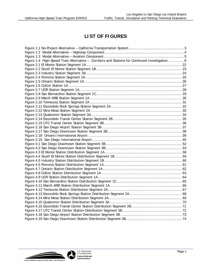
LIST OF FIGURES
Figure 1.1 No-Project Alternative – California Transportation System.................................................... 3 Figure 1.2 Modal Alternative – Highway Component........................................................................... 4 Figure 1.3 Modal Alternative – Aviation Component............................................................................ 5 Figure 1.4 High-Speed Train Alternative – Corridors and Stations for Continued Investigation............... 8 Figure 2.1 El Monte Station Segment 1A .......................................................................................... 22 Figure 2.2 South El Monte Station Segment 1B ................................................................................. 23 Figure 2.3 Industry Station Segment 1B........................................................................................... 24 Figure 2.4 Pomona Station Segment 1A ........................................................................................... 25 Figure 2.5 Ontario Station Segment 1A ............................................................................................ 26 Figure 2.6 Colton Station 1A ........................................................................................................... 27 Figure 2.7 UCR Station Segment 1A................................................................................................. 28 Figure 2.8 San Bernardino Station Segment 1C................................................................................. 29 Figure 2.9 March ARB Station Segment 1A ....................................................................................... 30 Figure 2.10 Temecula Station Segment 2A ....................................................................................... 31 Figure 2.11 Escondido Rock Springs Station Segment 2A................................................................... 32 Figure 2.12 Mira Mesa Station Segment 2A ...................................................................................... 33 Figure 2.13 Qualcomm Station Segment 3A...................................................................................... 34 Figure 2.14 Escondido Transit Center Station Segment 2B ................................................................. 35 Figure 2.15 UTC Transit Center Station Segment 3B.......................................................................... 36 Figure 2.16 San Diego Airport Station Segment 3B............................................................................ 37 Figure 2.17 San Diego Downtown Station Segment 3B ...................................................................... 38 Figure 2.18 Ontario International Airport......................................................................................... 39 Figure 2.19 San Diego International Airport..................................................................................... 40 Figure 4.1 San Diego Downtown Station Segment 3B........................................................................ 52 Figure 4.2 San Diego Downtown Station Segment 3B........................................................................ 53 Figure 4.3 El Monte Station Distribution Segment 1A......................................................................... 58 Figure 4.4 South El Monte Station Distribution Segment 1B ............................................................... 59 Figure 4.5 Industry Station Distribution Segment 1B ......................................................................... 60 Figure 4.6 Pomona Station Distribution Segment 1A.......................................................................... 61 Figure 4.7 Ontario Station Distribution Segment 1A........................................................................... 62 Figure 4.8 Colton Station Distribution Segment 1A ............................................................................ 63 Figure 4.9 UCR Station Distribution Segment 1A ............................................................................... 64 Figure 4.10 San Bernardino Station Distribution Segment 1C ............................................................. 65 Figure 4.11 March ARB Station Distribution Segment 1A.................................................................... 66 Figure 4.12 Temecula Station Distribution Segment 2A...................................................................... 67 Figure 4.13 Escondido Rock Springs Station Distribution Segment 2A ................................................. 68 Figure 4.14 Mira Mesa Station Distribution Segment 2A..................................................................... 69 Figure 4.15 Qualcomm Station Distribution Segment 3A .................................................................... 70 Figure 4.16 Escondido Transit Center Station Distribution Segment 2B................................................ 71 Figure 4.17 UTC Transit Center Station Distribution Segment 3B ........................................................ 72 Figure 4.18 San Diego Airport Station Distribution Segment 3B .......................................................... 73 Figure 4.19 San Diego Downtown Station Distribution Segment 3B..................................................... 74

Los Angeles to San Diego via Inland Empire California High-Speed Train Program EIR/EIS Traffic, Transit, Circulation and Parking Technical Evaluation
Page vi
U.S. Departmentof TransportationFederal RailroadAdministration
ACRONYMS
ARB Air Reserve Base
Authority California High-Speed Rail Authority
CCR California Code of Regulations
CEQA California Environmental Quality Act
CFR Code of Federal Regulations
EIR Environmental Impact Report
EIS Environmental Impact Statement
EPA Environmental Protection Agency
FAA Federal Aviation Administration
FHWA Federal Highway Administration
FRA Federal Railroad Administration
FTA Federal Transit Administration
GIS Geographic Information System
HST high-speed train
I- Interstate
IC Information Center
km/h kilometers per hour
LOSSAN rail corridor from Los Angeles to San Diego through Orange County
MOA Memorandum of Agreement
mph miles per hour
NEPA National Environmental Policy Act
RTP Regional Transportation Plans
SHPO State Historic Preservation Officer
SR State Route
STIP State Transportation Improvement Program
U.S. United States

Los Angeles to San Diego via Inland Empire California High-Speed Train Program EIR/EIS Traffic, Transit, Circulation and Parking Technical Evaluation
Page 1 January 2004
U.S. Departmentof TransportationFederal RailroadAdministration
1.0 INTRODUCTION
The traffic, transit, circulation and parking analyses for this program-level EIR/EIS were focused on a broad comparison of potential impacts to traffic, transit, circulation and parking along corridors for each of the alternatives (modal and high-speed train alternatives) and around stations. The potential impacts for each of these alternatives were compared with the No-Project Alternative. Highway, roadways, passenger transportation services (bus, rail, air, intermodal), transit facilities, goods movements and parking issue were evaluated in the analyses. Transportation facilities, highways and roadways included in the analyses: 1) serve as the primary means of access to proposed rail stations and airport facilities as well as highway/roadway improvements/new facilities in the Modal Alternative; and 2) are within one mile of proposed rail stations and (in the Modal Alternative) airports and major routes along alignment/highway corridors. Initial analysis included identifying primary routes to be considered including highways designated in the No-Project and Modal alternatives and all modes of access to the stations areas and airport areas in the Modal and HST Alternatives, respectively. The primary routes/modes of access for the stations and airports considered assumptions for distribution of trips by direction. Once primary routes were identified, screenlines or cordons combining segments of the primary routes which reasonably represent locations for evaluating in the aggregate baseline traffic and public passenger transportation conditions (using data for 2002, 2020 or other similar years as available) in the morning peak-hour were selected. No new traffic counts were made where data was not available, and the respective MPO regional travel forecasting models were assumed sufficiently accurate for purposes of forecasting traffic on the screenlines or cordons chosen. Baseline (2002 and 2020 as available data allowed) ratios of demand to capacity across each screenline or cordon for roadway and public transportation facilities were then established using Highway Capacity Manual standards for capacity. Next, baseline conditions (2002, 2020) were characterized for goods movement (truck/freight) in the general area of study (primarily to identify key goods movement means/corridors) and for parking in the vicinity of stations and airports. Parking conditions are based on any 2002 parking reserves, local plans for major parking expansion, and adequacy of local parking codes for meeting No-Project growth in demand. Trip generation was then calculated by adding to baseline volumes forecasted 2020 demand for high-speed rail and (for the Modal alternative) airports, or highways comprising alternatives, plus local trips in 2020 generated by project-related development (as data are available) and trips due to induced growth. Additional trips were distributed to the identified screenlines or cordons (roadway and public transportation) and added those trips to the appropriate baseline volumes for each screenline or cordon. Next, additional trips were distributed for selected segments/links on primary regional routes and modes of access to stations and similar facilities by adding No-Project volumes obtained from 2020 forecasts (from regional and local agencies), and 2020 travel demand generated by alternatives, to the key accessing facilities (roadways, transit links). This distribution was done at a screenline level to reduce the subjectivity of assigning trips to specific facilities. Summary tables for the region were then completed that identify impacts on highways/roadways (at screenline), public transportation services, goods movement, and parking facilities. The impacts are described and ranked as ‘high’, ‘medium’, or ‘low’ in the summary table according to the potential extent of change to traffic, transit, circulation and parking.

Los Angeles to San Diego via Inland Empire California High-Speed Train Program EIR/EIS Traffic, Transit, Circulation and Parking Technical Evaluation
Page 2 January 2004
U.S. Departmentof TransportationFederal RailroadAdministration
1.1 ALTERNATIVES UNDER CONSIDERATION
1.1.1. No-Project Alternative
The No-Project Alternative serves as the baseline for the comparison of Modal and High-Speed Train alternatives (Figure 1.1). The No-Project Alternative represents the state’s transportation system (highway, air, and conventional rail) as it existed in 1999-2000 and as it would be after implementation of programs or projects currently programmed for implementation and projects that are expected to be funded by 2020. The No-Project Alternative addresses the geographic area serving the same intercity travel market as the proposed high-speed train (generally from Sacramento and the San Francisco Bay Area, through the Central Valley, to Los Angeles and San Diego). The No-Project Alternative satisfies the statutory requirements under CEQA and NEPA for an alternative that does not include any new action or project beyond what is already committed. The No-Project Alternative defines the existing and future statewide intercity transportation system based on programmed and funded (already in funded programs/financially constrained plans) improvements to the intercity transportation system through 2020, according to the following sources of information:
• State Transportation Improvement Program (STIP)
• Regional Transportation Plans (RTPs) for all modes of travel
• Airport plans
• Intercity passenger rail plans (California Rail Plan 2001-2010, Amtrak Five- and Twenty-year Plans)
Recent history and the uncertainties of transportation financing in California point to a reality that many of the improvements identified in those plans will not be implemented, even by 2020. That notwithstanding, the No-Project Alternative is the best projection that can be made of year 2020 conditions, based on current local and regional planning policy. As with all of the alternatives, the No-Project Alternative will be assessed against the purpose and need topics/objectives for congestion, safety, air pollution, reliability, and travel times.
1.1.2 Modal Alternative
There are currently three main options for intercity travel between the major urban areas of San Diego, Los Angeles, the Central Valley, San Jose, Oakland/San Francisco, and Sacramento: vehicles on the interstate highway system and state highways, commercial airlines serving airports between San Diego and Sacramento and the Bay Area, and conventional passenger trains (Amtrak) on freight and/or commuter rail tracks. The Modal Alternative consists of expansion of highways, airports, and intercity and commuter rail systems serving the markets identified for the High-Speed Train Alternative (Figures 1.2 and 1.3). The Modal Alternative uses the same intercity travel demand (not capacity) assumed under the high-end sensitivity analysis completed for the high-speed train ridership in 2020. This same travel demand is assigned to the highways, airports, and passenger rail described under the No-Project Alternative.

Los Angeles to San Diego via Inland Empire California High-Speed Train Program EIR/EIS Traffic, Transit, Circulation and Parking Technical Evaluation
Page 3 January 2004
U.S. Departmentof TransportationFederal RailroadAdministration
Figure 1.1 No-Project Alternative – California Transportation System

Los Angeles to San Diego via Inland Empire California High-Speed Train Program EIR/EIS Traffic, Transit, Circulation and Parking Technical Evaluation
Page 4 January 2004
U.S. Departmentof TransportationFederal RailroadAdministration
Figure 1.2 Modal Alternative – Highway Component

Los Angeles to San Diego via Inland Empire California High-Speed Train Program EIR/EIS Traffic, Transit, Circulation and Parking Technical Evaluation
Page 5 January 2004
U.S. Departmentof TransportationFederal RailroadAdministration
Figure 1.3 Modal Alternative – Aviation Component
Los Angeles to San Diego via Inland Empire California High-Speed Train Program EIR/EIS Traffic, Transit, Circulation and Parking Technical Evaluation
Page 6 January 2004
U.S. Departmentof TransportationFederal RailroadAdministration
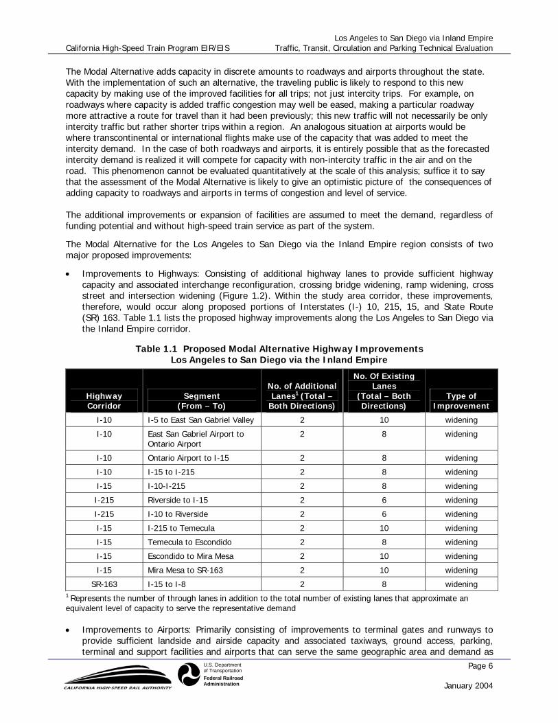
The Modal Alternative adds capacity in discrete amounts to roadways and airports throughout the state. With the implementation of such an alternative, the traveling public is likely to respond to this new capacity by making use of the improved facilities for all trips; not just intercity trips. For example, on roadways where capacity is added traffic congestion may well be eased, making a particular roadway more attractive a route for travel than it had been previously; this new traffic will not necessarily be only intercity traffic but rather shorter trips within a region. An analogous situation at airports would be where transcontinental or international flights make use of the capacity that was added to meet the intercity demand. In the case of both roadways and airports, it is entirely possible that as the forecasted intercity demand is realized it will compete for capacity with non-intercity traffic in the air and on the road. This phenomenon cannot be evaluated quantitatively at the scale of this analysis; suffice it to say that the assessment of the Modal Alternative is likely to give an optimistic picture of the consequences of adding capacity to roadways and airports in terms of congestion and level of service. The additional improvements or expansion of facilities are assumed to meet the demand, regardless of funding potential and without high-speed train service as part of the system.
The Modal Alternative for the Los Angeles to San Diego via the Inland Empire region consists of two major proposed improvements:
• Improvements to Highways: Consisting of additional highway lanes to provide sufficient highway capacity and associated interchange reconfiguration, crossing bridge widening, ramp widening, cross street and intersection widening (Figure 1.2). Within the study area corridor, these improvements, therefore, would occur along proposed portions of Interstates (I-) 10, 215, 15, and State Route (SR) 163. Table 1.1 lists the proposed highway improvements along the Los Angeles to San Diego via the Inland Empire corridor.
Table 1.1 Proposed Modal Alternative Highway Improvements Los Angeles to San Diego via the Inland Empire
Highway Corridor
Segment (From – To)
No. of Additional Lanes1 (Total –
Both Directions)
No. Of Existing Lanes
(Total – Both Directions)
Type of Improvement
I-10 I-5 to East San Gabriel Valley 2 10 widening
I-10 East San Gabriel Airport to Ontario Airport
2 8 widening
I-10 Ontario Airport to I-15 2 8 widening
I-10 I-15 to I-215 2 8 widening
I-15 I-10-I-215 2 8 widening
I-215 Riverside to I-15 2 6 widening
I-215 I-10 to Riverside 2 6 widening
I-15 I-215 to Temecula 2 10 widening
I-15 Temecula to Escondido 2 8 widening
I-15 Escondido to Mira Mesa 2 10 widening
I-15 Mira Mesa to SR-163 2 10 widening
SR-163 I-15 to I-8 2 8 widening 1 Represents the number of through lanes in addition to the total number of existing lanes that approximate an equivalent level of capacity to serve the representative demand
• Improvements to Airports: Primarily consisting of improvements to terminal gates and runways to provide sufficient landside and airside capacity and associated taxiways, ground access, parking, terminal and support facilities and airports that can serve the same geographic area and demand as

Los Angeles to San Diego via Inland Empire California High-Speed Train Program EIR/EIS Traffic, Transit, Circulation and Parking Technical Evaluation
Page 7 January 2004
U.S. Departmentof TransportationFederal RailroadAdministration
the proposed High-Speed Train (HST) Alternative. Within the study area corridor, these proposed improvements would occur at Ontario International Airport (ONT) and the San Diego International Airport (SAN) (Figure 1-3). Table 1-2 lists the airport improvements associated with the Ontario and San Diego airports.
Table 1.2 Proposed Modal Alternative Airport Improvements – Year 2020 Los Angeles to San Diego via the Inland Empire
Airport Name Additional Gates Additional runways
Ontario International Airport 8 1
San Diego International Airport 12 1
Source: Parsons Brinckerhoff, November 2002
1.1.3 High-Speed Train Alternative
The Authority has defined a statewide high-speed train system capable of speeds in excess of 200 miles per hour (mph) (320 kilometers per hour [km/h]) on dedicated, fully grade-separated tracks, with state-of-the-art safety, signaling, and automated train control systems. State-of-the-art, high-speed, steel-wheel-on-steel-rail technology is being considered for the system that would serve the major metropolitan centers of California, extending from Sacramento and the San Francisco Bay Area, through the Central Valley, to Los Angeles and San Diego (Figure 1-4).
The High-Speed Train Alternative includes several corridor and station options. A steel-wheel-on-steel-rail, electrified train, primarily on exclusive right-of-way with small portions of the route on shared track with other rail is planned. Conventional “nonelectric” improvements are also being considered along the existing rail corridor from Los Angeles to San Diego through Orange County (LOSSAN). The train track would be at grade, in an open trench or tunnel, or on an elevated guideway, depending on terrain and physical constraints.
For purposes of comparative analysis the high-speed train corridors will be described from station to station within each region, except where a bypass option is considered when the point of departure from the corridor will define the end of the corridor segment.
As intercity trips are diverted to the proposed HST system, the highway and aviation facilities will initially become less congested. The traveling public is likely to respond to this newly available capacity by making use of the facilities for all trips; not just intercity trips, similar to the situation described for the additional capacity in the Modal Alternative. Again, this phenomenon cannot be evaluated quantitatively at the scale of this analysis; suffice it to say that the assessment of the HST Alternative is likely to give an optimistic picture of the consequences of relieving congestion on roadways and airports in terms of level of service. As described in the introduction, the study area is broadly defined by the Los Angeles to San Diego via Inland Empire corridor segment, which may be broadly divided into three regional segments. Each segment has several alternative alignments for all or a portion of the length of the segment. For example, Segment 1 has three alternative alignments, listed as 1A, 1B, and 1C. Each segment is further subdivided into subsegments for analyzing and reporting potential impacts. The various segment options and subsegments, along with station locations, are described below.
1.1.3.1 Regional Segment 1 – Union Station to March Air Reserve Base Segment
1.1.3.1.1 Segment 1A
Subsegment 1A1: Union Station to Pomona Subsegment 1A2: Pomona to Ontario (beginning of Segment 1C)

Los Angeles to San Diego via Inland Empire California High-Speed Train Program EIR/EIS Traffic, Transit, Circulation and Parking Technical Evaluation
Page 8 January 2004
U.S. Departmentof TransportationFederal RailroadAdministration
Figure 1.4 High-Speed Train Alternative – Corridors and Stations for Continued Investigation

Los Angeles to San Diego via Inland Empire California High-Speed Train Program EIR/EIS Traffic, Transit, Circulation and Parking Technical Evaluation
Page 9 January 2004
U.S. Departmentof TransportationFederal RailroadAdministration
Subsegment 1A3: Ontario (beginning of Segment 1C) to Colton (end of Segment 1C) Subsegment 1A4: Colton to March Air Reserve Base (ARB)
1.1.3.1.2 Segment 1B
Subsegment 1B1: Union Station to Pomona
1.1.3.1.3 Segment 1C
Subsegment 1C1: Ontario (beginning of Segment 1C) to Colton (end of Segment 1C)
Station Locations: El Monte (1A1), Pomona (1A2), Ontario (1A2), Colton (1A3), University of California at Riverside (1A4), South El Monte (1B1), City of Industry (1B1), and San Bernardino (1C1)
1.1.3.2 Regional Segment 2 – March ARB to Mira Mesa Segment
1.1.3.2.1 Segment 2A
Subsegment 2A1: March ARB to Escondido (beginning of Segment 2B) Subsegment 2A2: Within Escondido (beginning to end of Segment 2B) 1.1.3.2.2 Subsegment 2A3: Escondido to Mira Mesa
1.1.3.2.3 Segment 2B
Subsegment 2B1: Within Escondido (Beginning to end of Segment 2B)
Station Locations: March ARB (2A1), Temecula (2A2), Escondido (2A2), and Escondido Transit Center(2B1)
1.1.3.3 Regional Segment 3 – Mira Mesa to San Diego Segment
1.1.3.3.1 Segment 3A
Subsegment 3A1: Mira Mesa to Qualcomm Stadium
1.1.3.3.2 Segment 3B
Subsegment 3B1: Within Mira Mesa (beginning and end of Segment 3C) Subsegment 3B2: Mira Mesa (end of Segment 3C) to Downtown San Diego
1.1.3.3.3 Segment 3C
Subsegment 3C1: Within Mira Mesa (end of Segment 3C)
Station Locations: Mira Mesa (3A1), Qualcomm Stadium (3A1), Transit Center (3B2), San Diego International Airport (3B2), and Downtown San Diego (3B2)

Los Angeles to San Diego via Inland Empire California High-Speed Train Program EIR/EIS Traffic, Transit, Circulation and Parking Technical Evaluation
Page 10 January 2004
U.S. Departmentof TransportationFederal RailroadAdministration
2.0 BASELINE/AFFECTED ENVIRONMENT
2.1 STUDY AREA
Los Angeles-to-San Diego via the Inland Empire corridor will run from Los Angeles Union Station to Riverside along existing rail corridors or new rights-of-way and from Riverside to San Diego along the I-15/I-215 Corridor. The corridor is divided into three segments for analysis purposes as described in Section 1.2.3. Based on the identified alignments, seventeen potential rail stations are identified and traffic, transit, circulation and parking analyses are performed for each proposed station. The proposed rail stations are El Monte, South El Monte, City of Industry, Colton, Pomona, Ontario International Airport North, San Bernardino, University of California at Riverside, March ARB, Temecula, Escondido Rock Springs Road Station, Mira Mesa Station, Qualcomm Station, Downtown Escondido Transit Center Station, University Town Center Transit Center Station, San Diego Airport Station, and Downtown San Diego Station, which are described below in further detail. The intercity highways affected by the modal alternative within the Los Angeles and Riverside counties included I-10 and I-215 and within San Diego County included I-15 and SR 163. The Ontario International Airport and San Diego International Airport are the only airports affected by the modal alternative within this corridor.
2.2 GENERAL DESCRIPTION OF TRANSPORTATION FACILITIES
The physical characteristics of HSR stations, intercity highways and airports are discussed in this section. See Appendix A for conceptual site plans for each station location. The following potential station locations have been identified:
• El Monte (West of the I-605 Along the UP Colton Line) - This site would provide connections with
both Metrolink and local bus service from an adjacent bus transfer station. It also is located in the center of El Monte and offers good access from the surrounding community. The streets in the vicinity of the station are Durfee Avenue, Vally Boulevard and Garvey Avenue.
• South El Monte (East of the I-605 South of SR-60) - This site provides good access to and from
the area freeway system. The streets in the vicinity of station are Peck Road, Workman Mill Road and Pellissier Place.
• City of Industry Station - This site provides good linkages with Metrolink commuter rail service
and serves the East San Gabriel Valley. The streets and freeways in the vicinity of station are Valley Boulevard, Lemon Ave, Brea Canyon road, SR-60 and SR-57.
• Colton - This location is directly on the UP Colton Line with good accessibility from I-10. This
location currently does not have good transit or multimodal connections. The streets in the vicinity of station are Locust Avenue, Cedar Avenue, Bloomington Avenue, San Bernardino Avenue, Valley Boulevard.
• Pomona Station - The Pomona Station allows a multimodal transfer station with Metrolink and
local buses at an existing historic station site. The station is on the edge of the downtown area

Los Angeles to San Diego via Inland Empire California High-Speed Train Program EIR/EIS Traffic, Transit, Circulation and Parking Technical Evaluation
Page 11 January 2004
U.S. Departmentof TransportationFederal RailroadAdministration
and has reasonable access. The streets in the vicinity of station are Mission Boulevard and Garey Avenue,
• Ontario Airport North Station - A station here provides a multimodal connection with Ontario
International Airport. The station site includes some land that is currently vacant.
• San Bernardino - This location serves the existing Santa Fe Depot that has both Amtrak and adjacent Metrolink service. There are issues with sitting a high-speed train station due to the train and BNSF intermodal facilities located there; however, it serves a major population center and it has good transit and multimodal connections. It has limited parking.
• University of California at Riverside - The existing right-of-way runs through this area and a new
station site could be developed here. The streets and freeway in the vicinity of station are Watkins Drive, Canyon Crest Drive, Martin Luther King Boulevard and I -215.
• March Air Reserve Base (ARB) - This site is outside the city of Riverside and a station here would
be a newly developed facility. As March ARB is redeveloped, a station site in this area could serve some of the planned development.
• Temecula – This site is located near the I-215/I-15 Junction. The streets in the vicinity of station
are Murrieta Hot Springs road and Hancock Ave.
• Escondido Rock Springs Road Station – This site is located in the City of Escondido southwest of the I-15/El Norte Parkway interchange. The study area included I-15, El Norte Parkway, Nordahl Road and Rock Springs Road. Access to the station would be from Rock Springs Road and Borden Road, which provides access to El North Parkway.
• Mira Mesa Station – This site is located in the City of San Diego southwest of the I-15/Mira Mesa
Boulevard interchange. The study area included I-15, Mira Mesa Boulevard, Hillery Drive, Westview Parkway, Black Mountain Road, and Carroll Canyon Road. Access to the station would be from Hillery drive, which has access to Westview Parkway and Black Mountain Road.
• Qualcomm Station – This site is located in the City of San Diego southwest of the I-15/Friars
Road interchange. The study area included I-15, Friars Road, San Diego Mission, and Mission Village Drive. Access to the station would be from Friars Road.
• Escondido Transit Center Station – This site is located in the downtown area of the City of
Escondido. The study area included I-15, SR-78, Quince Street, Center City Parkway, Washington Avenue, and Valley Parkway. Access to the station would be from Quince Street.
• University Town Center Transit Center Station – This site is located in the City of San Diego
southwest of the I-805/Nobel Drive interchange. The study area included I-805, Nobel Drive, Towne Center Drive, and Genesee Avenue. Access to the station would be from Nobel Drive.
• San Diego Airport Station – This site is located in the City of San Diego south of the I-
5/Washington Street interchange. The study area included I-5, Pacific frontage road, Pacific Highway, Witherby Street, Washington Street, and Hancock Street. Access to the station would be from Pacific frontage road.
• Santa Fe Depot San Diego Station – This site is located in the downtown area of the City of San
Diego. The study area included Pacific Highway, Kettner Street, Ash Street, Broadway, and North Harbor Drive. Access to the station would be from Pacific Highway and from Kettner Street.

Los Angeles to San Diego via Inland Empire California High-Speed Train Program EIR/EIS Traffic, Transit, Circulation and Parking Technical Evaluation
Page 12 January 2004
U.S. Departmentof TransportationFederal RailroadAdministration
The baseline roadways to be used in the station analysis are summarized in Table 2.1.
Table 2.1. - Primary Roads Serving Stations
Station Location
El Monte Station (1A) Valley Blvd( Puente and Vineland )
Durfee Ave( Peck and Valley)
Peck Rd( Durfee and Mountain View)
Garvey Ave( Tyler and Peck)
Peck Rd( Ramona and Valley)
Ramona Blvd( Cogswell and Durfee)
South El Monte Station (1B) Workman Mill Rd( Peck and Rose Hills)
Durfee Ave( Rosemead and Santa Anita)
Santa Anita Ave( SR-60 and Durfee)
Peck Rd( Mountain View and Durfee)
Workman Mill Rd( SR-60 and Valley)
City of Industry Station (1B) Colima Rd( Fairway and Lemon)
Valley Blvd( Fairway and Lemon)
Lemon Ave( Puente and Valley)
Valley Blvd( Grand and Lemon)
Golden Springs Dr( Diamond Bar and Grand)
Grand Ave( Golden Springs and Diamond Bar)
Pomona Station (1A) Holt Blvd( East End and Reservior)
Mission Blvd( East End and Reservior)
Reservoir St( Phillips and Grand)
Towne Ave( Phillips and Grand)
Garey Ave( Phillips and Grand)
White Ave( Phillips and Grand)
Mission Blvd( Dudley and Hamilton)
Holt Blvd( Dudley and Hamilton)
White Ave( McKinley and I-10)
Garey Ave( La Verne and I-10)
Towne Ave( I-10 and San Bernardino)
Ontario Station (1A) Hermosa Ave( 6th and 4th )
Vineyard Ave( 4th and Inland Empire)
4th St( Haven and Hermosa)
Inland Empire Blvd( Haven and Archibald)
Mission Blvd( Archibald and Vineyard)
Archibald Ave( Juropa and Lowell)
Holt Blvd( Groves and Vineyard)
4th St( Vineyard and Archibald)
Archibald Ave( 4th and Inland Empire)
Colton Station (1A) Locust Ave( San Bernardino and Randall)
Cedar Ave( San Bernardino and Randall)
Bloomington Ave( San Bernardino and Randall)
San Bernardino Ave( Cactus and Riverside)

Los Angeles to San Diego via Inland Empire California High-Speed Train Program EIR/EIS Traffic, Transit, Circulation and Parking Technical Evaluation
Page 13 January 2004
U.S. Departmentof TransportationFederal RailroadAdministration
Valley Blvd( Cactus and Riverside)
Slover Ave( Cedar and Riverside)
Cedar Ave( Juropa and Santa Ana)
Locust Ave( Juropa and Santa Ana)
Santa Ana Ave( Alder and Locust)
Slover Ave( Palmetto and Alder)
Valley Blvd( Palmetto and Alder)
San Bernardino Ave( Alder and Locust)
UCR Station (1A) Watkins Dr( Blaine and SR-60)
(Riverside) Canyon Crest Dr( Country Club and Central)
University Ave( Chicago and Canyon Crest)
Martin Luther King Blvd( Chicago and Canyon Crest)
San Bernardino Station (1C) Rock Springs Rd(Nordahl Rd and W. Mission Ave)
Nordahl Rd(Rock Springs Rd and El Norte Pkwy)
El Norte Pkwy(Nordahl Rd and I-15)
Mira Mesa Blvd(Black Mountain Rd and Westview Pkwy)
Hillerly Drive(Black Mountain Rd and Maya Linda Road)
Westview Pkwy(Mira Mesa Blvd and Hillery Drive )
Black Mountain Rd(Mira Mesa Blvd and Carroll Canyon Rd)
Carroll Canyon Ro(Black Mountain Rd and Scripps Ranch)
Friars Rd(Qualcomm Wy and Mission Gorge Rd)
San Diego Mission(Mission Village Dr and Mission Gorge Rd)
Mission Village Dr(Ruffin Rd and Friars Rd)
Quince St(W. Washington Ave and Valley Pkwy)
March ARB Station (1A) Center City Pkwy(SR-78 and W. 9th Ave)
(Riverside) W. Washington Ave(Rock Springs Rd and Broadway )
Valley Pkwy(I-15 and Broadway )
Nobel Dr(Genesee Ave and I-805)
Towne Centre Dr(La Jolla Village Dr and Nobel Dr)
Temecula Station (2A) Genesee Ave(La Jolla Village Dr and Governor Dr)
(Temecula) Pacific (frontage rd)(Witherby St and Washington St)
Pacific Highway(Witherby St and Washington St)
Escondido Station Segment 2A Witherby St(Pacific Hwy and Hancock St)
Washington St(Pacific Hwy and Hancock St)
Hancock St(Witherby St and Washington St)
Mira Mesa Station Segment 2A Pacific Highway(Hawthorn St and Harbor Dr)
Kettner (1-way)(Hawthorn St and Harbor Dr)
Ash (1-way)(North Harbor Dr and State St)
Broadway(North Harbor Dr and State St)
North Harbor Dr(Hawthorn St and Pacific Hwy)
Qualcomm Station Segment 3A Rock Springs Rd(Nordahl Rd and W. Mission Ave)
Nordahl Rd(Rock Springs Rd and El Norte Pkwy)
El Norte Pkwy(Nordahl Rd and I-15)
Escondido Transit Center Station Segment 2B Mira Mesa Blvd(Black Mountain Rd and Westview Pkwy)
Hillerly Drive(Black Mountain Rd and Maya Linda Road)
Westview Pkwy(Mira Mesa Blvd and Hillery Drive )

Los Angeles to San Diego via Inland Empire California High-Speed Train Program EIR/EIS Traffic, Transit, Circulation and Parking Technical Evaluation
Page 14 January 2004
U.S. Departmentof TransportationFederal RailroadAdministration
Black Mountain Rd(Mira Mesa Blvd and Carroll Canyon Rd)
University Town Center Transit Center Station Segment 3B Carroll Canyon Ro(Black Mountain Rd and Scripps Ranch)
Friars Rd(Qualcomm Wy and Mission Gorge Rd)
San Diego Mission(Mission Village Dr and Mission Gorge Rd)
San Diego Airport Station Segment 3B Mission Village Dr(Ruffin Rd and Friars Rd)
Quince St(W. Washington Ave and Valley Pkwy)
Center City Pkwy(SR-78 and W. 9th Ave)
W. Washington Ave(Rock Springs Rd and Broadway )
Valley Pkwy(I-15 and Broadway )
Downtown San Diego Station Segment 3B Nobel Dr(Genesee Ave and I-805)
Towne Centre Dr(La Jolla Village Dr and Nobel Dr)
Genesee Ave(La Jolla Village Dr and Governor Dr)
Pacific (frontage rd)(Witherby St and Washington St)
Pacific Highway(Witherby St and Washington St) The baseline transit routes and roadways within the vicinity of stations are summarized in Table 2.2.
Table 2.2 - Primary Roads Serving Stations with Bus Routes
Station Streets Bus Route Destination
El Monte Station (1A)
2.2.1.1.1.1.1.1 FT495
2.2.1.1.1.1.1.2
-Diamond Bar/Rowland Heights Express Service To Downtown Los Angeles -Fairplex Park - Ride Express Service To Downtown Los Angeles
Valley Blvd
270 484
-Monrovia/El Monte/Whittier/Santa Fe Springs/Norwalk/Cerritos
-Pomona/La Puente/Valley Bl./LAExpress
I-605
FT495
2.2.1.1.2 FT493
-Diamond Bar/Rowland Heights Express Service To Downtown Los Angeles -Phillips Ranch/Rowland Heights Express Service To Downtown Los Angeles
Durfee Ave 270 -Monrovia/El Monte/Whittier/Santa Fe Springs/Norwalk/Cerritos
Peck Rd
EMYEL 270
-Tyler Av./Fineview St./Magnolia St./Elliot Av./Valley Bl./Santa Anita -Monrovia/El Monte/Whittier/Santa Fe Springs/Norwalk/Cerritos
Garvey Ave
70 EMGRE FT486
FT493
-LA/El Monte via Garvey Av. -Mountain View Rd./Elliot Av./Garvey Av./Mildred St./Ramona Bl. -Cal Poly Pomona/Puente Hills Mall/ Baldwin Park/El Monte Busway Station/ Los Angeles -Phillips Ranch/Rowland Heights Express Service To Downtown Los Angeles
Ramona Blvd
490
FT488
-CSU Fullerton/Brea Mall/Lanterman Developmental Center./Cal Poly Pomona/ Walnut/Covina/Baldwin Park -Glendora/West Covina/El Monte Busway Station/Los Angeles
South El Monte Station (1B)
Workman Mill Rd 270
FT274 -Monrovia/El Monte/Whittier/Santa Fe Springs/Norwalk/Cerritos
-Whittier-Glendora, Puente Av./Citrus Av.

Los Angeles to San Diego via Inland Empire California High-Speed Train Program EIR/EIS Traffic, Transit, Circulation and Parking Technical Evaluation
Page 15 January 2004
U.S. Departmentof TransportationFederal RailroadAdministration
NW1 -Rio Hondo/Bellflower
I-605
FT495
FT493
-Diamond Bar/Rowland Heights Express Service To Downtown Los Angeles -Phillips Ranch/Rowland Heights Express Service To Downtown Los Angeles
San Gabriel River Pkwy
M60 -North Pico Rivera to South Pico Rivera
Durfee Ave M60 265
-North Pico Rivera to South Pico Rivera -Lakewood/Paramount Bl./Pico Rivera
Santa Anita Ave FT269 FT482
- El Monte Bus Station/ Montebello Town Center -Los Angeles/Hacienda Heights/Pomona via Colima Rd.
Peck Rd
270 EMYEL
-Monrovia/El Monte/Whittier/Santa Fe Springs/Norwalk/Cerritos-Tyler Av./Fineview St./Magnolia St./Elliot Av./Valley Bl./Santa Anita
City of Industry Station (1B) SR-57
Colima Rd
FT482 FT495
FT493
- Los Angeles/Hacienda Heights/Pomona via Colima Rd. -Diamond Bar/Rowland Heights Express Service To Downtown Los Angeles -Phillips Ranch/Rowland Heights Express Service To Downtown Los Angeles
SR-60
Valley Blvd 484 FT482
-Pomona/La Puente/Valley Bl./LAExpress -Los Angeles/Hacienda Heights/Pomona via Colima Rd.
Lemon Ave 484 FT289
-Pomona/La Puente/Valley Bl./LAExpress -Puente Hills Mall-Walnut/Pomona
Golden Springs Dr
FT853 FT493
FT495
OC757 FT482 FT854
-Golden Springs/Diamond Bar Ranch High School -Phillips Ranch/Rowland Heights Express Service To Downtown Los Angeles -Diamond Bar/Rowland Heights Express Service To Downtown Los Angeles -Santa Ana/Brea/Diamond Bar Park – Ride -Los Angeles/Hacienda Heights/Pomona via Colima Rd. -Golden Springs/Diamond Bar Ranch High School Via Diamond Bar Bl.
Grand Ave
490
484 FT178 FT289
-CSU Fullerton/Brea Mall/Lanterman Developmental Center./Cal Poly Pomona/ Walnut/Covina/Baldwin Park -Pomona/La Puente/Valley Bl./LAExpress -Cal Poly Pomona via Puente Av./El Monte Busway Station -Puente Hills Mall/Walnut/Pomona
Pomona Station (1A) Holt Blvd
484 FT482 FT292 FT294 FT195 FT855
-Pomona/La Puente/Valley Bl./LAExpress -Los Angeles/Hacienda Heights/Pomona via Colima Rd. -Pomona/Claremont/Montclair -Pomona/Claremont Colleges/ Claremont/Montclair -Cal Poly Pomona via Reservoir St. -Pomona TransCenter/ Claremont
Mission Blvd FT480 - Wilshire District/Los Angeles/El Monte/West Covina/Pomona/Claremont/Montclair
East End Ave
Reservoir St FT195 -Cal Poly Pomona via Reservoir St.
Towne Ave FT291 -Garey Av./Foothill Bl.
Garey Ave FT291 FT193
-Garey Av./Foothill Bl. -Cal Poly Pomona via Ninth St.
White Ave FT193 FT852
-Cal Poly Pomona via Ninth St. -Pomona TransCenter/ Fairplex
I-10
FT699 FT190
-Fairplex Park - Ride Express Service To Downtown Los Angeles -Montclair/Pomona Fairplex-Cal Poly Pomona
White Ave FT193 FT852
-Cal Poly Pomona via Ninth St. -Pomona TransCenter/ Fairplex

Los Angeles to San Diego via Inland Empire California High-Speed Train Program EIR/EIS Traffic, Transit, Circulation and Parking Technical Evaluation
Page 16 January 2004
U.S. Departmentof TransportationFederal RailroadAdministration
San Bernardino Ave FT855 FT192
-Pomona TransCenter/ Claremont
Ontario Station (1A) Hermosa Ave
Haven Ave
60 67 68 70
-Chaffey College/Ontario Mills -Fontana/Chaffey College -Indian Hill/Montclair/Chaffey College -Montclair/Ontario/Rancho Cucamonga
4th St
60 61 63 65 68 70
-Chaffey College/Ontario Mills -Fontana/Ontario/Pomona -Chino/Ontario/Upland -Montclair/Chino Hills -Indian Hill/Montclair/ Chaffey College -Montclair/Ontario/Rancho Cucamonga
Ontario Mills Pkwy
I-10 Fwy 90 -Montclair/Ontario/San Bernardino
Airport Dr
Jurupa St
29 70 71
-Fontana/Cedar/North Rialto -Montclair/Ontario/Rancho Cucamonga -Fontana/Country Village/Ontario
Archibald Ave
60 61
70-A 71
-Chaffey College/Ontario Mills -Fontana/Ontario/Pomona -Montclair/ Ontario/Rancho Cucamonga -Fontana/Country Village/Ontario
Holt Blvd
61 63 70
-Fontana/Ontario/Pomona -Chino/Ontario/Upland -Montclair/Ontario/Rancho Cucamonga
Colton Station (1A) Locust Ave
Cedar Ave 29 -Fontana/Cedar/North Rialto
Bloomington Ave
San Bernardino Ave 19 61
-Redlands/Colton/Fontana -Fontana/Ontario/Pomona
Valley Blvd 22 1
-North Rialto/South Rialto -Colton/Del Rosa
I-10 Fwy 90 -Montclair/Ontario/San Bernardino
Slover Ave 29 71
-Fontana/Cedar/North Rialto -Fontana/Country Village/Ontario
Cedar Ave 29 -Fontana/Cedar/North Rialto
Santa Ana Ave 29 -Fontana/Cedar/North Rialto
Slover Ave 29 71
-Fontana/Cedar/North Rialto -Fontana/Country Village/Ontario
UCR Station (1A) Watkins Dr
SR-60 -Downtown Terminal to Moreno Valley City Hall—Riverside/ Moreno Valley
Canyon Crest Dr
Orange Blossom Express Trolley
16
-Downtown Riverside; Riverside Market Place; University of California, Riverside 31 -Downtown Terminal to Moreno Valley City Hall—Riverside/ Moreno Valley
Central Ave
13 16
20
99
-UCR to Galleria at Tyler -Downtown Terminal to Moreno Valley City Hall—Riverside/ Moreno Valley -Magnolia Center, RCR Med. Cntr, Moreno Valley Community Hospital -Moreno Valley to Riverside Metrolink Station
Martin Luther King 16 -Downtown Terminal to Moreno Valley City Hall—Riverside/
Los Angeles to San Diego via Inland Empire California High-Speed Train Program EIR/EIS Traffic, Transit, Circulation and Parking Technical Evaluation
Page 17 January 2004
U.S. Departmentof TransportationFederal RailroadAdministration
Blvd 99
Moreno Valley -Moreno Valley to Riverside Metrolink Station
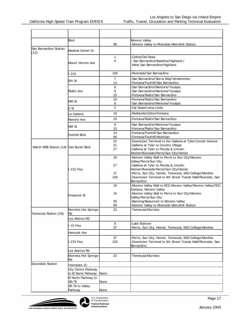
San Bernardino Station (1C) Medical Center Dr
Mount Vernon Ave
1 4
-Colton/Del Rosa - San Bernardino/Baseline/Highland / West San Bernardino/Highland
I-215 100 -Riverside/San Bernardino
5th St 7 14
-San Bernardino/Sierra Way/Verdemonte -Fontana/Foothill/San Bernardino
Rialto Ave
8 9 15
-San Bernardino/Mentone/Yucaipa -San Bernardino/Mentone/Yucaipa -Fontana/Rialto/San Bernardino
Mill St 15 8
-Fontana/Rialto/San Bernardino -San Bernardino/Mentone/Yucaipa
E St 2 -Cal State/Loma Linda
La Cadena 19 -Redlands/Colton/Fontana
Rancho Ave 15 -Fontana/Rialto/San Bernardino
Mill St 8 15
-San Bernardino/Mentone/Yucaipa -Fontana/Rialto/San Bernardino
Foothill Blvd 14 66
-Fontana/Foothill/San Bernardino -Fontana/Foothill/Montclair
March ARB Station (1A) Van Buren Blvd
10 21 27
-Downtown Terminal to the Galleria at Tyler/Lincoln Avenue -Galleria at Tyler to Country Village -Galleria at Tyler to Florida & Lincoln, Hemet/Riverside/Perris/Sun City/Hemet
I-215 Fwy
19
27
37 100
-Moreno Valley Mall to Perris to Sun City/Moreno Valley/Perris/Sun City -Galleria at Tyler to Florida & Lincoln, Hemet/Riverside/Perris/Sun City/Hemet -Perris, Sun City, Hemet, Temecula, MSJ College/Menifee -Downtown Terminal to 4th Street Transit Mall/Riverside, San Bernardino
Frederick St
18
19
35 99
-Moreno Valley Mall to RCC-Moreno Valley/Moreno Valley/RCC Campus, Moreno Valley -Moreno Valley Mall to Perris to Sun City/Moreno Valley/Perris/Sun City -Banning/Beaumont to Moreno Valley -Moreno Valley to Riverside Metrolink Station
Temecula Station (2A) Murrieta Hot Springs Rd
23 -Temecula/Murrieta
Los Alamos Rd
I-15 Fwy 8 37
-Lake Elsinore -Perris, Sun City, Hemet, Temecula, MSJ College/Menifee
Hancock Ave
I-215 Fwy 37 100
-Perris, Sun City, Hemet, Temecula, MSJ College/Menifee -Downtown Terminal to 4th Street Transit Mall/Riverside, San Bernardino
Los Alamos Rd
Murrieta Hot Springs Rd
23 -Temecula/Murrieta
Interstate 15 City Centre Parkway to El Norte Parkway None El Norte Parkway to SR-78 None
Escondido Station
SR 78 to Valley Parkway None

Los Angeles to San Diego via Inland Empire California High-Speed Train Program EIR/EIS Traffic, Transit, Circulation and Parking Technical Evaluation
Page 18 January 2004
U.S. Departmentof TransportationFederal RailroadAdministration
Rock Springs Road Nordahl Road to West Mission Avenue 356 El Norte Pkwy/City Centre Pkwy Loop
Nordahl Road Rock Springs Road to El Norte Parkway None
El Norte Parkway
Nordahl Road to I-15 359/359 Downtown Escondido Loop
Interstate 15 Scripps Poway Parkway to Mira Mesa Blvd.
20/810/820/850/860/ 980/990 Various destinations, All Express
Mira Mesa Boulevard to Carroll Canyon Road
810/820/850/ 860/980/990 Various destinations, All Express
Mira Mesa Boulevard Black Mountain Road to Westview Parkway 21/964/963/30/210 Various Destinations
Hillery Drive Black Mountain Road to Maya Linda Road None
Westview Parkway Mira Mesa Boulevard to Hillery Drive None
Black Mountain Road Mira Mesa Boulevard to Carroll Canyon Road
963/964/20/210/990/ 980 Various Destinations
Carroll Canyon Road
Mira Mesa Station
Black Mountain Road to Scripps Ranch 31/30/990/980 Various Destinations
Interstate 15 Aero Drive to Friars Road 60 UTC to Euclid Trolley Friars Road to Interstate 8 60 UTC to Euclid Trolley
Friars Road Qualcomm Way to Mission Gorge Road 13 SDSU to Fashion Valley
San Diego Mission Mission Village Drive to Mission Gorge Road None
Mission Village Drive
Qualcomm Station
Ruffin Road to Friars Road 13 SDSU to Fashion Valley
Interstate 15 SR-78 to Valley Parkway None Valley Parkway to Auro Park Way None
SR-78
Escondido Transit Center Station
Interstate 15 to City Centre Parkway 320 Oceanside-Escondido
Escondido Transit Center Quince Street

Los Angeles to San Diego via Inland Empire California High-Speed Train Program EIR/EIS Traffic, Transit, Circulation and Parking Technical Evaluation
Page 19 January 2004
U.S. Departmentof TransportationFederal RailroadAdministration
W. Washington Avenue to Valley Pkwy. 347 Escondido-CSU San Marcos
City Centre Parkway SR-78 West 9th Avenue 810, 878 Various Destinations W. Washington Avenue Rock Springs Road to Broadway None
Valley Parkway
Station (cont.)
state 15 to Broadway 348, 308, 810 Various Destinations
Interstate 805 Miramar Road to Nobel Drive 60/210 UTC-EU Trolley/Mira M. to Kearny M. Nobel Drive to Governor Drive 60/210 UTC-EU Trolley/Mira M. to Kearny M.
Nobel Drive Genesee Avenue to Interstate 805 None
Town Centre Drive La Jolla Village Drive to Nobel Drive 150 UTC to Downtown San Diego
Genesee Avenue
University Town Centre Station
La Jolla Village Drive to Genesee Avenue 34/41/5 Various Destinations
Interstate 5 Interstate 8 to Washington Street 30/50/150 Various Destinations Washington Street to Pacific Viaducts 30/50/150 Various Destinations
Pacific Highway Witherby St. to Washington St. (Frontage Rd) None Witherby Street to Washington Street 34/34A/908 Various Destinations
Witherby Street Pacific Highway to Hancock Street None
Washington Street Pacific Highway to Hancock Street 908 North Park to Sports Arena
Hancock Street
San Diego Airport Station
Witherby Street to Washington Street None
Pacific Highway Hawthorn Street to Harbor Drive 2/4/40/70 Various Destinations Kettner Boulevard (1-way) Hawthorn Street to Harbor Drive 5 UTC to Downtown San Diego
Downtown San Diego Station
Ash Street (1-way)

Los Angeles to San Diego via Inland Empire California High-Speed Train Program EIR/EIS Traffic, Transit, Circulation and Parking Technical Evaluation
Page 20 January 2004
U.S. Departmentof TransportationFederal RailroadAdministration
North Harbor Drive to State Street 16 Sierra Mesa to Downtown San Diego
Broadway North Harbor Drive to State Street 15 different routes County Wide
North Harbor Drive
Hawthorn Street to Pacific Highway 16 different routes County Wide
The following intercity highways have been identified for analysis:
• I-10 from I-5 to East San Gabriel Valley - This freeway section consists of a total of 8 mainline lanes in rolling terrain.
• I-10 from I-5 East San Gabriel Valley to Ontario Airport - This freeway section consists of a total of 8 mainline lanes in rolling terrain.
• I-10 from Ontario Airport to I-15 - This freeway section consists of a total of 8 mainline lanes in rolling terrain.
• I-10 from I-15 to I-215 - This freeway section consists of a total of 8 mainline lanes in rolling terrain.
• I-15 from I-10 to I-215 - This freeway section consists of a total of 6 mainline lanes in rolling terrain.
• I-215 from Riverside to I-15 - This freeway section consists of a total of 6 mainline lanes in rolling terrain.
• I-215 from I-10 to Riverside - This freeway section consists of a total of 4 mainline lanes in rolling terrain.
• I-215 from I-15 to Temecula - This freeway section consists of a total of 8 mainline lanes in rolling terrain.
• I-15 from Temecula to Escondido – This freeway section consists of a total of 8 mainline lanes in rolling terrain.
• I-15 from Escondido to Mira Mesa – This freeway section consists of a total of 10 mainline lanes in rolling and level terrain.
• I-15 from Mira Mesa to SR 163 – This freeway section consists of a total of 10 mainline lanes in level terrain.
• SR 163 from I-15 to I-8 – This freeway section consists of a total of 8 mainline lanes in level and rolling terrain.
The following airport facilities have been identified for analysis: Ontario International Airport – This airport is located approximately 40 miles east of Los Angeles in the Inland Empire region. The medium-hub airport is owned and operated by the City of Los Angeles through Los Angeles World Airports (LAWA), which also owns and operates Los Angeles International, Van Nuys and Palmdale Regional Airports. The cordon streets for this analysis included Airport Dr WB (Commerce Pkwy and Haven), Airport Dr EB (Grove and Vineyard), Vineyard (D St and Holt), Archibald (I-10 Fwy and Airport Dr) San Diego International Airport – This airport is the primary commercial service airport in the San Diego region. It is served by one runway and is classified as a “large hub” commercial airport by the Federal Aviation Administration. The cordon streets for this analysis included Pacific Highway, Laurel Street, Hawthorn Street, Grape Street, and North Harbor Drive.

Los Angeles to San Diego via Inland Empire California High-Speed Train Program EIR/EIS Traffic, Transit, Circulation and Parking Technical Evaluation
Page 21 January 2004
U.S. Departmentof TransportationFederal RailroadAdministration
2.3 SCREENLINES COMBINING SEGMENTS OF THE PRIMARY ROUTES
The screenlines, collector level or higher roadways that would provide primary access to the stations, are identified as streets that intersect a cordon within a one mile radius of the proposed rail stations. These streets are considered for screenlines and establish a perimeter that captures traffic crossing the boundary to each station. Screenlines for each station are shown in Figures 2.1 through 2.19.

Los Angeles to San Diego via Inland Empire California High-Speed Train Program EIR/EIS Traffic, Transit, Circulation and Parking Technical Evaluation
Page 22 January 2004
U.S. Departmentof TransportationFederal RailroadAdministration
Figure 2.1 El Monte Station Segment 1A

Los Angeles to San Diego via Inland Empire California High-Speed Train Program EIR/EIS Traffic, Transit, Circulation and Parking Technical Evaluation
Page 23 January 2004
U.S. Departmentof TransportationFederal RailroadAdministration
Figure 2.2 South El Monte Station Segment 1B

Los Angeles to San Diego via Inland Empire California High-Speed Train Program EIR/EIS Traffic, Transit, Circulation and Parking Technical Evaluation
Page 24 January 2004
U.S. Departmentof TransportationFederal RailroadAdministration
Figure 2.3 Industry Station Segment 1B