los trancos site guide
TRANSCRIPT
O ENVIRONMENTAL VOLUNTEERS
EARTHQUAKE SITE GUIDE
FORLOS TRANCOS
&MONTE BELLO
TRAILS
3921East Bayshore RoadPalo Alto, CA 94303
(6s0) 96L-054s

TABLE OF CONTENTSfor
EARTHQUAKE SITE GUIDE
EV Mission & Objective .......... ....... ' ........." ' i
Introd'uction """""" """""page 1
Plate Tectonics """"'pages 1 & 2
Fault Action..... """"'Pages 2 & 3
Taking Children on the Earthquake Trail...... .............pa ges 4 - 7
Los Trancos Map """"""Page7a
Los Trancos Trail ""'Pages 7 - t0
Monte Bello Map......... 'pagelTa
Monte Bello Trai1......". """"""pages L1 - 15
Earthquake Trail Vocabulary .............. ....pages 15 - 17
Paper Model - Fault Movement Affect on Land Surface.... .'....'.'.....Page 18
Paper Model - Rock Transport """'page 19
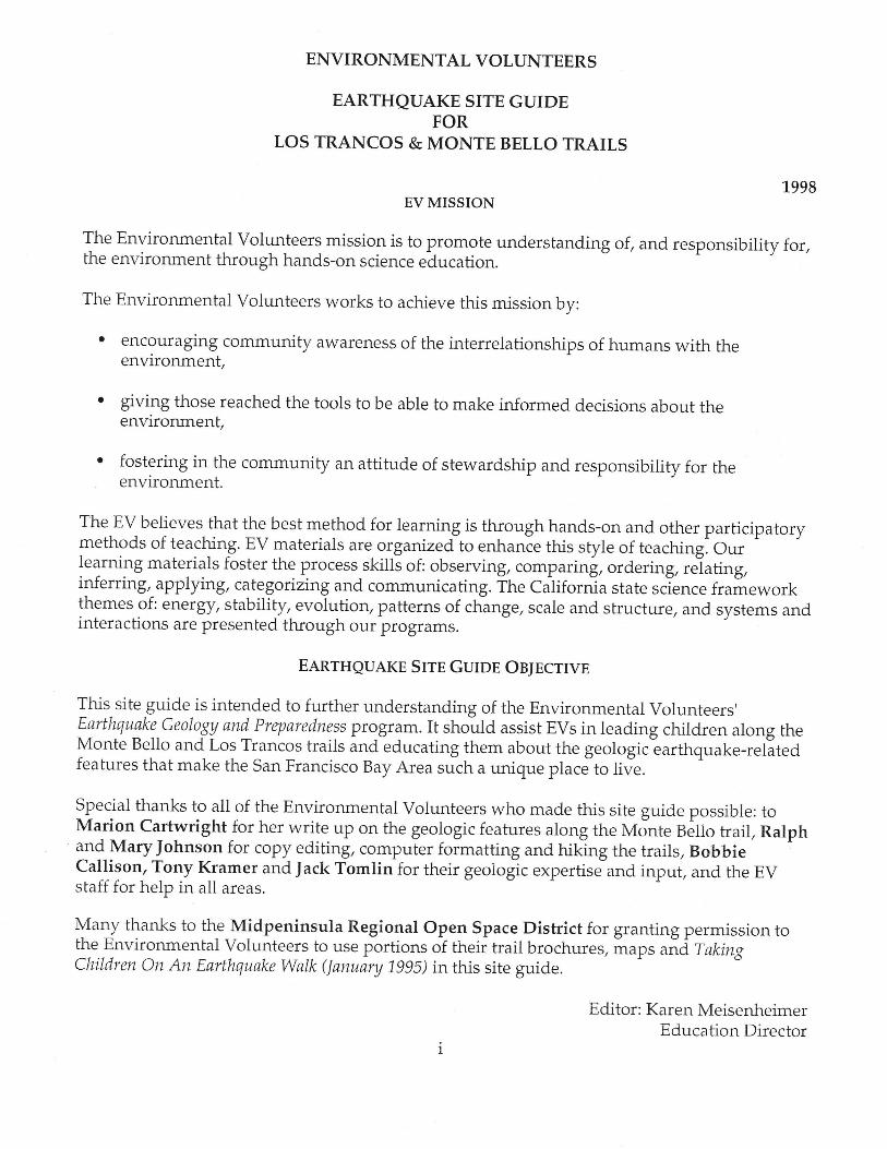
ENVIRONMENTAL VOLUNTEERS
EARTHQUAKE SITE GUIDEFOR
LOS TRANCOS & MONTE BELLO TRAILS
EV MISSION 1-998
The Environmental Volunteers mission is to promote understanding of, and responsibility for,the environment through hands-on science education.
The Environmental volunteers works to achieve this mission by:
' encouraging community awareness of the interrelationships of humans with theenvironment,
giving those reached the tools to be able to make informed d,ecisions about theenvironment,
fostering in the community an attitude of stewardship and responsibility for theenvironment.
The EV believes that the best method for learning is through hands-on and other participatorymethods of teaching. EV materials are orgarizedto enhanie this style of teaching. Our 'learning materials foster the process skills of: observing, comp ating, ordering, reiating,inferring, applying, categoizing and communicating. ffre Catiforria state science frameworkthemes of: energy, stability, evolution, patterns of chinge, scale and structure, and systems andinteractions are presented through our programs.
EARTHQUAKE S[TE GUIOE OB;ECTWE
This_site guide is intended to further understanding of the Environmental Volunteers'Earthquake.Geology and PrEaredne,ss program. It should assist EVs in leading children along theMonte Bello and Los Trancos trails and educating them about the geologic-earthquake-relitedfeatures that make the San Francisco Bay Area such a unique ptace to tive.
Special thanks to all of the Environmental Volunteers who made this site guide possible: toMa11on CartwrightJor her wrife up on the geologic features along the Monte getto trail, Ralph1n{ MaryJohnson for copy editing, computer formatting and hiking the trails, BobbieCallison, Tony Kramer and Jack Tomlin for their geologlc expertisJand input, and the EVstaff for help in all areas.
Yu.y thanks to the Midpeninsula Regional Open Space District for granting permission tothe Environmental Volunteers to use portions of their trail brochures, iraps uia f omngChildren on An Earthquake walk (lanuary 199s) in this site guide.
Editor: Karen MeisenheimerEducation Director

Ittf
N
cP
ncc.srcr.at-\i
pz-.c krn 1 L"JH."*
J,\
Los Trancos:From Highway 280 - Take Highway 280 to Page Mill Roadexit. Take Page Mill Road west toward the hills. Parking lotis on the right just past Monte Bello Open Space Preserve onthe left. This is approximately 7 miles from 280. It is alsoabout 7 miles from 280 and El Monte/Moody Road exit.Allow about 30 minutes from the freeway exit.From Skyline Blvd - Take Skyline to Page Mill Roadintersection. Turn onto Page Mill Road going toward PaloAlto and the Bay- Los Trancos parking lot is approximately1-3 miles on your left.
S.1n3o:.q 1
\"".\ g_.\\5Pa-r Kr
{
Al
/, .*_-r-l \ .
HOWTO GETTHERE...
7 miles, 1A hour drive from Foothill College7 miles from intersect ion l -280 and Page Mil lRoad.
l f you are wi l l ing to recycle this brochure, pleasereturn it to the box at the trailhead.
{colqlzl
- lY
lsi^qssry
LOS TRANCOS
OPEN SPACEPRESERVE
SAr\ Ar\DXIASr | i l - r - rn A l lI -AUL I I KAIL
Tt ie t ra i l starts on the lef t s ide of the parking lot .
page L
ENVIRONMENTAL VOLUNTEERSEARTHQUAKE TRAIL SITE GUIDE
INTRODUCTION:
The Los Trancos and Monte Bello Open Space Preserves are ideal places to teach children about
earthquake-related features. The San Andreas fault, one of the world's longest and most active
faults; splits the two preserves. The Los Trancos trail highlights geological features along the
San Andreas fault and encompasses a L kilometer (.6 mile) loop in the Los Trancos Preserve,
and the Monte Bello hail highlights geological features along the San Andreas fault and
encompassesLg.2 kilometer (12 mile) loop in the Monte Bello Preserve. (See enclosed maps for
Los Trancos and Monte Bello trails.)
As the Pacific plate moves, sliding past the North American plate, the friction between these
plates tries to prevent that movement, causing the rocks to bend. This stores uP energy much
like a coiled spring The amount of the stored energy eventually overcomes the friction gluing
the edges of the plates together and they spring into a new position. This is called the elastic
rebound theory. This snap releases some of the accumulated energy resulting in an earthquake,
possibly of extreme magnitude. Since the North American and Pacific plates continue to move
each year, as they have for millions of years, future major earthquakes in the Bay Area are
inevitable.
These trails were constructed for the residents of the San Francisco Peninsula, with the hope
that the more they know about their unique geographic environment and how it relates to
earthquake activity, the better they will be able to protect themselves and their property against
injury or damage.
EARTHQUAKE HIKE FOCUS ENABLES STUDENTS TO:
1) Observe the visible evidence of large scale geological forces acting on the landscape over
t ime,2) Develop understanding of fault dynamics and the results of fault action,
3) Create an impression of the enormous time scale and forces involved in changing the
landscape,Develop an appreciation for the kinds of changes that can occur immediately in event of an
earthquake,Experience a unique trek along side and on top of the San Andreas fault.
PLATETECTONTCS:Throughout history, different cultures have offered many explanations for the cause of
earthq-uakes. Some Native American tribes told the "The Turtle Story" to explain how the
Great Spirit formed the earth on the backs of giant turtles. When the turtles argued, they
swam in different directions which caused the earth to shake. According to Japaneselegends, earthquakes are caused by a giant catfish that lives in the mud beneath the earth.
AJ long as thekasima god holds ine fisn down with a weight, the earth is quiet. But if the
god reLxes his hold, th; fish wiggles, and the earth shakes. Today, geologists have proved
ihut t*elrre major plates and miny minor plates are "floating" on a hot, plastic-like layer in
the earth's upper mantle. Most plates carry both continental land and ocean floor on the
crust of their "backs."
4)
5)
Environmental Volunteers @ Earthquake site Guide for Los Trancos and Monte Bello Trails
page 2
PLATES: (cont inued)The current term used for this constant movement of plates is plate tectonics. Alfred
Wegener (1880-1930) is credited with the formal outline of the theory of "continental drift."
Based on observations of the shape of continents, matching rock and fossil records from
different continents and other geblogical findings, Wegener was convinced that the
continents were "jigsaw pieces; that had drifted away from one super-continental "ptzzle"
millions of years ago. Wegener thought that it was the continents alone that were in
motion. The similaiity of early animal and plant fossil remains found on different
continents is strong urrid"r,." iupporting the continental drift theory, but at the time he
postulated his theo-ry he was discrediteJby his peers.-They did not feel that the similarity of
species on different continents offered adequate proof'
Today we know that both the ocean floor and the continental masses ride along ol th"
backs of giant, moving crustai plates. The existing boundaries of the earth's crustal plates are
dramaticilly outlined"by globaibands of earthquake activity and volcanoes- Scientists have
created gruphi. simulatiois of the entire history of piate movement based on a wealth of
geologiciat iindir,gt. Pangaea, Greek Jor "all land," the name Wegener gave to the ancient
3.rp"J.o.rtinent, ior..,edirrer 250 million years ago. As Pangaea began to- break up, the
amount of shoreline increased. and the shape and size of the oceans on the globe changed'
New life forms flourished. with these changes. The continents sitting on their plates
continue to slowly drift, collide and reshape the face of our globe.
Although the boundaries of some plates remain uncertain, and the existence of smaller
plates #itnitr plates is still being questioned, the following 12 maior plates have been
identified:1. PACIFIC2. NORTH AMERICAN3. COCOS4. CARIBBEAN5. NAZCA6. SOUTH AMERICAN
7. AFRICAN8. ARABIAN9. EURASIAN
10. INDIAN-AUSTRALIAN11.. PHILIPPINE12. ANTARCTIC
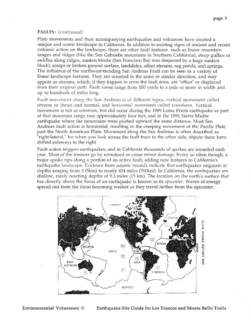
Some other minor plates that have been identified by geologists are: Iran, Caroline,
Bismark, solomon's, Gorda, scotia and Juan de Fuca. The plate boundary around the Pacific
Ocean is called the ;'ring of fire" because of the heavy concentration of earthquakes (80% of
all quakes) and volcanoes (95%) that occur along this belt. A portion of the ring cuts
through the length of California, separating the Pacific Plate from the North American Plate
alongl boundary known as the San Andreas Fault'
FAULT ACTION:California is laced with a network of active geologic faults, or weak fracture zones in the
rock formations that underlie the state. The San Andreas Fault System describes the entire
complex of faults that spread out along the entire lelSth of the San Andreas and includes
the Hayward Fault and many of the smaller faults that transverse the San Francisco Bay
Area. California has the distinction of being the boundary between the Pacific and North
American plates. The san Andreas fault is the longest strike-slip fault in the world. As the
two plates grind past each other, the resulting friction causes strain to build up in the rocks
deep withii the earth. Eventually the rocks break apart and move to a new position,,
releasing energy in the form of earthquakes. After-this release of energy, new strains begin
to buildalot g it "
fault, starting the next stress release rycle.
Environmental Volunteers @ Earthquake site Guide for Los Trancos and Monte Bello Trails
page 3
FAULTS: (cont inued)
Plate movements and their accompanying earthquakes and volcanoes have created aunique and scenic landscape in California. In addition to existing signs of ancient and recentvolcanic action on the landscape, there are other fault features such as linear mountainranges and ridges (like the San Gabrielle mountains in Southern California), steep gullies orsaddles along ridges, sunken blocks (San Francisco Bay was deepened by a huge sunkenblock), scraps or broken ground surface, landslides, offset streams, sag ponds, and springs.The influence of the northwest-trending San Andreas Fault can be seen in a variety oflinear landscape features. They are oriented in the same or similar direction, and mayappear as streams, which, if they happen to cross the fault zorre, are "offset" or displacedfrom their original path. Fault zones range from 100 yards to a mile or more in width andup to hundreds of miles long.
Fault movement along the San Andreas is of different types, vertical movement calledreverse or thrust and normal, and horizontai movement called transform. Verticalmovement is not as common, but did occur during the 1989 Loma Prieta earthquake as partof that mountain range rose approximately four feet, and in the 1991 Sierra Madreearthquake where the mountains were pushed upward the same distance. Most SanAndreas fault action is horizontal, resulting in the creeping movement of the Pacific Platepast the North American Plate. Movement along the San Andreas is often described as"right-lateral," for when you look across the fault trace to the other side, objects there haveshifted sideways to the right.
Fault action triggers earthquakes, and in California thousands of quakes are recorded eachyear. Most of the tremors go by unnoticed or cause minor damage. Every so often though, amajor quake rips along a portion of an active fault, adding new features to California'searthquake landscape. Evidence from seismic records indicate that earthquakes originate atdepths ranging from 3 (Skm) to nearly 434 miles (700km). In California, the earthquakes areshallow, rarely reaching depths of 9.3 miles (15 km). The location on the earth's surface thatlies directly above the focus of an earthquake is known as its epicenter.Waves of energyspread out from the focus becoming weaker as they travel farther from the epicenter.
I A[[Ri<l P ,;T#sr*is
-tl
AF-lm
NN
Foc
oq
3
q?PACrfrc
a!)
c3*d5v
Environmental Volunteers O Earthquake Site Guide for Los Trancos and Monte Bello Trails
Page 4
TAKING CHILDREN ON THE EARTHQUAKE TRAIL
ORIENTATION:
Rattlesnakes are native to these foothills and are especially active in warm weather. By staying onthe trail you will see the snake before you might step on it.
Lyme's Disease: The ticks that carry this disease are prevalent in the area. Prudence requires that bystaying on trails, checking socks and pants, tick bites and infection can be avoided. You have twelvehours to safely rernove a tick before the chance of infection will occur.
Poison Oak leaves are three-lobed. They secrete an oil which causes extreme skin irritation.
Note to field trip leaders: Pick and choose among all the activities listed in this guide, using asmany as time allows and focusing on the ones with which you feel most comfortable.
Make vour exDectations clear!
Leaders need to set the tone at the beginning of the hike as well as at each station of activity.Children will not know what you expect of them unless you tell them.
. Tell your students what kind of behavior you expect from them. Let them know how to be"successful." We are the caretakers of the preserae today, so I'il need eaeryone to make surewe aII stay on the trails, pick up litter, and take care of all the plants and animals we comencross. Do you think we can do that?
. Act as a role model. For instance, stay on the trail if you've asked the children to always stayon the trail.
o Let the children know what to expect during the hike. If they are constantly asking whenthey'll get to climb Rattlesnake Hill, and you'll be taking them there at the end of the hike,tell them this.
' Try to anticipate problems before they happen. Stay a mental step ahead of your group.Identify "high energy" children and keep them busy, maybe by giving them specificresponsibilities or tasks to carry out.
Making your expectations clear at the beginning of your hike is the best way to avoid behaviorproblems. But if they do arise, think about how you could have avoided them and how toprevent the same problem from reoccurring during the rest of your hike.
. Tell children what you want them to do. Don't assume that they know what behavior youexpect or why. I'd like it if eoeryone would look at me ushile I explain how this works.
. Trytoavoidsaying, Don't do this, don't do thnt.Tell chi ldren what they should do. Pleasezoalk, instead of; Don't run!
r tlse "I" statements. I'd like it if. . . t like it when ttou. . .
Environmental Volunteers @ Earthquake Site Guide for Los Trancos and Monte Bello Trails
' Have the children consider the consequences of inappropriate behavior.happen if eaeryone took this shortcut? what might happen if ute alt climb
' Challenge children to demonstrate an alternative behavior. What else canelse can we.
page 5
What wouldon this old fence?
we do to. . . How
Keeping children involved and focused will decrease chances of behavior problems.
o Some children learn best by seeing, some by listening, and some by doing. A combination ofactivities that use all three of these methods will help insure that your group will get mostout of the experience.
o If everyone is involved in what you are doing, there won't be anyone left to "act up." Usegames and activities that get them doing things, not just listening and watching.
. One way to capture the group's attention is to change your mode of presentation. Whisper,use an accent, alter the volume of your voice, etc.
. Call a child by his or her name whenever possible. If addressed by name, a child will respondto your request much quicker. Don't you like it better when someone calls you by nameinstead of "hey you?"
o Ask open and closed-ended questions. Closed-ended questions have a specific answer tothem. An example of a closed-ended question is: What plate are we standing on7 or What isthe name of this type of rock? Open-ended questions have many answers and can generatediscussion. An example of an open-ended question is: How csn we better prepare ourselaesfor an earthquake? What landscape features do you find interestingT What clues do you seeT
o Ask questions to get children involved. Make a point to involve those individual childrenwho aren't already involved. What do you think Melissa? Billy, would you. . .
o Be aware of body language. Is your group's focus where you want it?
Children will pay attention better if the information you convey is on their level.
. Talk to the children with respect. They are peopie!
o Get down on their level and look them in the eyes.
o FeeI out your group's level of knowledge by asking them questions. Listen to the kinds ofanswers they give and questions they ask. If they tell you that earthquakes are caused byvolcanoes, you know you will need to give them some basic information.
o Convey information in terms the children understand, in ways that have relevance to theirlives. Pudding stone makes more sense to children than conglomerates.
o Set an atmosphere that allows children to discover things rather than telling themeverything. How does that side of the mountain differ from this side? What might that tellus about what has happened in the past?
Environmental Volunteers @ Earthquake Site Guide for Los Trancos and Monte Bello Trails
Page 6
Answer questions with questions. Why do you think it's that rnay? Promote speculations asto how and why things are the way they are. When you don't know the answer, say so.
IJse "active listening" by being sure you understand what you are being asked. What's thatTcould mean almost anything.
Stay flexible. You may not be able to lead Lour hike exactly as you had planned.
. Encourage student observations by paying close attention to them and generatingenthusiasm for their discoveries.
. Value diversity. Different children have different needs, talents, and abilities.
. Avoid stereotyping children by their gender or race. Don't expect that only boys will want toget dirty, or that girls will be afraid of spiders.
. Develop a bag of tricks. Keep learning new activities and ways of explaining things, so thatyou can keep your presentation fresh and fun for you, too. If your group is high energy, youmay need more physical activities for explaining things.
. Be able to laugh at yourself; a sense of humor will keep everyone else in good spirits.
Remember, we are here to introduce children to earthquakes and geology. We can't teach them(or adults) everything there is to know about this complex topic during a short hike.
Your field trip begins in the parking lot, tell the students that not many people have theopportunity to walk the boundary of two plates. Here, along the San Andreas Fault zone, /oucan actually straddle the North American and Pacific plates.
You may wish to continue by stating; Today our goal is to discoaer clues that tell us we areznalking on an actiae fault zone. We will be 'reading the landscape' Iooking for clues. At theend of the hike we'll reaiew the clues ue discoaered.Let's get ourselues oriented. Which direction is West? Where is the Pacific Ocean? What plateis the western plnte? Which wny is East? What plate is the eastern plate? Which way is North,South? If you are using a compass, orient the group to the compass directions and general trendof the San Andreas Fault dynamics. Without a compass you can reckon due north by Mt.Diablo; it is almost due North of the preserve.
Using the plate diagram (see copy), point out where your group is in relation to the plates. (Youcan make a copy of this and seal it with clear plastic Contact paper to demonstrate platemovements and relationships to the San Andreas Fault.)
Rock Lifting - to get a sense of the weight and mass of rocks in the landscape and the hugeforces necessary to move them, have each person lift a large sample rock. Discuss the sfudents'reactions.
Ceo-Word Match - hand out cards with earthquake geology terms and definitions. When a newterm is mentioned as you proceed along the trail, give one of the students the appropriate cardand have him or her help explain the term and point out the feature in the landscape.
Environmental Volunteers @ Earthquake Site Guide for Los Trancos and Monte Bello Trails

One Mi le
LOSTRANCOS
Open Space Preserve
page 7
SPecial Requests - ask what each person would especially like to see on the field trip, dispelsome earthquake myths in the process.
Rock Hunt - in your pack carry some small specimens of rocks which you know the group willfind along the trail. As you encounter different rocks, ask the group to match them with yoursmall samples.
Each hike leader should have a copy of the trail guide maps.
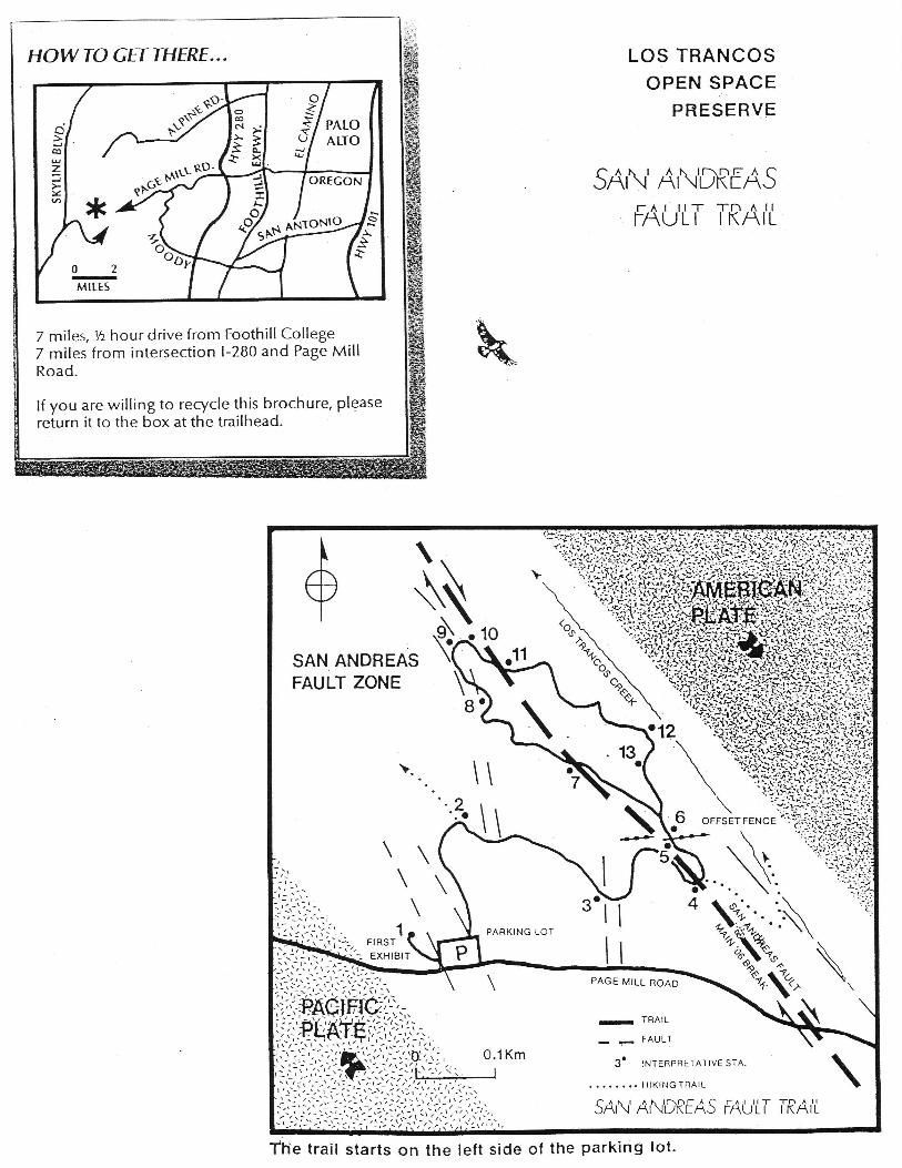
LOS TRANCOS TRAIL
INTRODUCTION:
The Los Trancos Open Space I'reserve is an ideal spot to learn about earthquake related geologicfeatures. The San Andreas fault, one of the world's longest and most active faults, splits thePreserve. This trail encompasses a portion of the San Andreas fault along a 1 kilometer (.6mile) loop established by volunteers' assistance, geology professor Tim Hall, Nick Hall andFoothill College geology students.
To understand how earthquakes happen, we must first look at the way in which a fault, like theSan Andreas, is formed. The earth's outer crust is a jigsaw puzzle of rock plates approximately100 kilometers (60 miles) thick. These plates float upon a viscous sea of hot, plastic-like rock.When two plates move against each other, the jagged rock edges break forming a weak areacalled a fault zone. Since the North American and Pacific plates will continue to move eachyear, as they have for millions of years, future major earthquakes in the Bay Area areinevitable. This trail was constructed for the residents of the San Francisco Peninsula, with thehope that the more they know about their geographic environment, the better they will be ableto protect themselves and their property against injury or damage as a result of futureearthquakes.
See the enclosed map of the Los Trancos trail for orientation to the stations described belou.
The trail begins on the left (western) side of the parking lot. Pass through the fence opening andgo up the hill to station one. Stations are indicated by numbered posts. Posts with yellow bandsmark the main fault break and white bands mark minor fault breaks.
STATION ONE:
The large boulders at your feet are a distinctive type of conglomerate (a sedimentary rock madeof round pebbles) that came from Loma Prieta, a mountain on the North American plate 38kilometers (23 miles) to the southeast. On a clear day you may be able to identify this mountainon the southern skyline. Between 1 and 2 million years ago streams carried these boulders fromthe flanks of Loma Prieta westward across the San Andreas fault and deposited them on thePacific Plate. Recurring movements along the San Andreas have shifted them into theirpresent position beneath your feet.
Below you, the parking lot sits on the southern edge of a shallow depression called a sag pond,which was caused by fault movement. On the far side of the sag pond, the line of posts withwhite stripes marks a minor fault within the San Andreas zone that moved slightly in 1906.There are only two types of places (aside from human-created) along the coastal range whereponds are formed these are along faults and where there have been landslides.
Environmental Volunteers O Earthquake Site Guide for Los Trancos and Monte Bello Trails
page 8
Rock Transport - using the plate shift diagram, with the sketch of conglomerate rocks on LomaPrieta Mountain, show how plate movement has brought these rocks to their current locationat the Lost Trancos site; discuss where they will go in the future.
Sag Pond Overview - from the hill overlooking the branch fault and the sag pond, point outthe straight line nature of the ridge and fault trace area; note that there is no natural outlet forthe water that collects in the sag pond. Look for plants that live in moist areas such as: curlydock, sedges, and cattails.
Continue along the trail, when you come to the fire break turn right and walk on to stationfwo.
STATION TWO:
Standing directly uphill from the marker you can easily follow the line of the San Andreasfault as it heads northwestward toward San Francisco. Look for the some Bay Area landmarks:Crystal Springs Reservoir and San Andreas Lake. The reservoir and the lake, used for storingSan Franciscan's water supply, were built in the 1800fs by damming the fault-produced valleyalong the San Andreas. Headwaters for Stevens, Los Trancos and Corte Madera Creeks beginalong the elevated ridge you are standing on.
The Faulty Landscape - have your group identify as many fault features as possible whileoverlooking the valley and the Bay Area. You should be able to identify Crystal SpringsResewoir (was originally a sag pond), San Andreas Lake, East Bay Hills along the HaywardFault line. Discuss the benefits of earthquake activity: a reservoir for San Francisco's watersupply, the picturesque hills, long linear valleys. Discuss factors that might be part of themountain building processes.
The Water-Colored Landscape - using the color of the land as a guide, speculate on thedifferences in soil and geology that may contribute to the different vegetation cover; discuss therole of water in the landscape.
STATION THREE
After the 1906 earthquake, a Stanford student observed that the fence along Page Mill Road wastorn apart 10 centimeters (4 inches). Notice the moist ground in the depression between PageMill Road and the station marker. Grinding action along the faults which border thisdepression have reduced the bedrock to clay which acts as a barrier to the downhill flow ofunderground water. Often water will bubble up to the surface from the water table at a low spotalong a fault and form a spring.
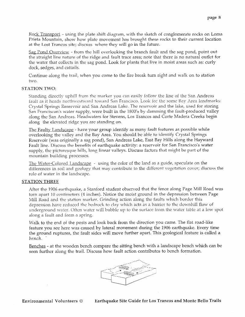
Walk to the end of the posts and look back from the direction you car,ne. The flat road-likefeature you see here was caused by lateral movement during the 1906 earthquake. Every timethe ground ruptures, the fault sides will move further apart. This geological feature is called abench.
Benches - at the wooden bench compare the sitting bench with a landscape bench which can be
seen further along the trail. Discuss how fault action contributes to bench formation.
Environmental Volunteers @ Earthquake Site Guide for Los Trancos and Monte Bello Trails

Page 9
STATION FOUR:
The fence you see here has been reconstructed from century-old materials found on thePreserve' On the downhill side of the trail you can see an original section of fence. The 1906quake may have moved the far (right hand) segment as much as 3 feet in a northwesterlydirection. The fault moved at a rate of 5,000 miles per hour.
Fence Tumpins - with group lined up along the fence, have a few people be the Pacific Platesection and have them jump the 3 feet of movement that occurred in the 1906 earthquake.
Epicenter String Game - another way of demonstrating why people can feel the effects of strongearthquakes many miles away from the epicenter; discuss ripple effects and P and S waves.Flave the group count off. Using 6 foot. lengths of yarn or string, have those with even-numbers form a circle, those with odd numbers will hold one end of string and give the otherend to an even number, then go and stand on the opposite side of the circle. Ail strings shouldcross each other in the center. Have the whole group close their eyes, the group leader shouldpluck strings at center point (epicenter), from underneath. The whole group wili feel thevibrations simulating "earthquake waves" as they travel away from the epicenter.
STATION FIVE:
Notice the willows and abundant undergrowth to the left of the trail. These plants are cluesthat here there is more water available. As faults move, rock is ground into a fine clay, called
fault gouge. The clay binds the crushed rock and forms a barrier to the flow of undergroundwater. The water builds up on the uphill side of the fault and bubbles out of the ground. Here isan example of a spring coming to the surface along a clay barrier produced by faulting. Waterfrom the spring has saturated the fault-weakened rocks on this steep hillside and caused alandslide downhill to your right. Landslides like this are often triggered by big earthquakes. Thearea below the willows is a recovering landslide area.
STATION SIX:
You have crossed back over the main fault again.
Before you are excellent examples of a sag pond and a road-like bench (upon which the faultmarkers stand.) These are features that often develop along major horizontally-moving faultslike the San Andreas. Sag ponds like this one indicate that the earth's crust here was stretchedby faulting which allowed parts of the hillside to sink. Once this sag pond fills with sedimentwashed in from the surrounding slopes, it will become (evolve into) a hillside bench.
As you continue along the trail, note that you are walking along a slight linear ridge, higherthan the sag pond. This ridge runs parallel to the land contours and is called a pressure ridge.
Sand. Clay and Water - using two film canisters with small holes punched in the bottom, onehalf-filled with sand, the other with clay. Ask students to predict which is most porous; pourwater in both canisters and demonstrate which is most porous. Compare this with the springand the clay barrier that causes water to bubble up to the surface.
Environmental Volunteers @ Earthquake Site Guide for Los Trancos and Monte Bello Trails
Page 10
STATION SEVEN:
On each side of the trail is an interesting oak tree. They were probably thrown down by violentground shaking in1906, but managed to survive and continue to grow. The main trunks of thetrees are growing parallel to the ground, with their large branches growing vertically. Whencore samples of the trunks were taken, the rings showed that the trunks date to L899. Thevertical limbs, however, date to 1908.
Oak Tree Branches - facing the large oak tree, have the group stand with their arms straight out;feel their arms getting heavy and visualize the fact that oak branches can't bend like willowbranches; pretend that there is a strong earthquake - what happens to the branches?
STATION EIGHT:
Since climbing the hill, you have moved west of the main 1906 faulting, but you are stil l wellwithin the San Andreas fault zone. The posts in front of you mark a guliy eroded into shatteredrocks along a minor fault. Notice how the gully is almost parallel to the hillside. If there was no
fault, the water eroded gully would run straight downhill, perpendicular to the land contours.
STATION NINE:
Here you can see a number of earthquake features. On your left is a linear valley and above is a
linear ridge. You are standing on another linear ridge. The minor fault breaks here do not form
a continuous straight line as does the main break. As you continue along the trail, you will
approach the main 1906 break again. See if you can recognize it.
Notice the familiar, road-like bench in front of you and on your left. This is the main fault
break. Hidden beneath the tangle of poison oak and brush on your right is another sag pond.
Imagine the awesome power that lies temporarily locked beneath your feet!
Below you is Los Trancos Creek, which is following yet another old line of broken rock within
the San Andreas fault zone. On the far side of the creek, there is an outcrop of light graylimestone, but brush overgrowth obscures it.
Creek Listening - have group stand very quietly for a moment; discuss what they hear. Listen
again with hands cupped behind ears; does it make a difference? Discuss large ears and keen
hearing of animals. Ask: Can animals hear or sense earthquakes before humans can?
Water Cycle - overlooking the creek, discuss where the water comes from, where it is going,
how it effects the landscape, how fault movement relates to the water flow, etc.
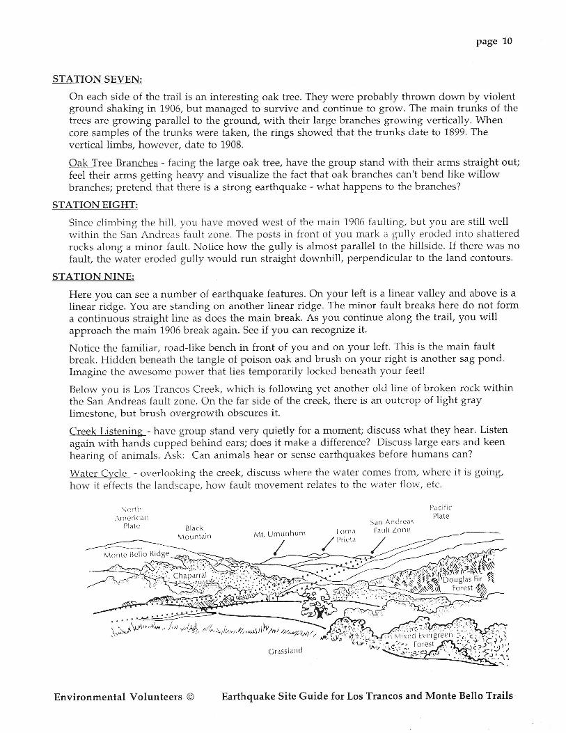
North\r l er ica n
PI ate
Paci f icPl ate
San AndreasFault Zone
M()rr tc Bel lo Ridge
Mt. Umunnt lm Loma
// l'riLt.\
':'.'. " -parrali . l .:r i i
Cha^ ' . 'Douglas Fir2\\2\
Foresl
i'i ;(ffi-"', 1d, //,, r, 1,,,, rt,, u* t rfu n t ";;, \oG\r
' t ; l
C rasslan d
Environmental Volunteers @ Earthquake Site Guide for Los Trancos and Monte Bello Trails

lI
Los Trancos
Page Mi l lRoad
Legend
t I ' ]ark ing Area
.. Trai l (Hikers Only)
- Trai l (Hikers, Equestr ians,Bicycl ists)
. . . . . . . o. t . . Closed to Bicycles
Scale in Mi les
g '117 1
lNorth
i . r , , r { )Mr11 . , . . . . . . . t , . . , . l ( , t ! . r \ t , , I i , l r , . ' i l r l
k , t r t t t t t ,J t t " t t
" t ' i t , , r1 'hr l 1r4, ,
te Uel lo
Open Space Preserve
Skyl ine RidgeOperr Space Preserve
7 mrles, 14 hourdr ivefronr Foothi l lCol lege7 mi les f rom intersect ion l -280 arrd PagcMil l Road.
l f \ or are wi l l ing 1o rc(y( l t ' th is brochurt ' ,p lease return i t io the box.r t the t ra i lhcad.
ate
\,
.\t,.,' I' t
Skyl ine'Floulevard
(l-, i- - r ) v/I
i: .'' iskvlineCburity eark
(ContactSanta ClaraCo. Parks
f-pr bicycle
&"$*""t'
i'\-,-.
I A,, lourl talnt\
II
1b SaratogaCalr
/ \
\I
\I
',',"ii',r,',,,,.1i,
MONTE BELLO
AlpineRoad
-,ate
- - r - - \\- I - :WH
l /-...:--r'ss/3----_-
l-C't t t r ' " '
- \^ t t ' ' ' ' ' ' Bt l l t '
t*ila*,,**),'\-., -"''...{l'i'-,n ;'n-'--
=---'\o,
\-_\ / /
t \ . ,
- ' - ' ,- ' - t r,rd,r,r c' l". 'k t ' r ir1r
\ t -^ ,
. , . . /
\
StevensCreek
tI Cult l \ \ r re 7
(-rcrrk /
a ' :
t1 Canl 'orr '
\ Trai l , i
\,,>)Il--\
\
\ / \ . /' .
t i - . . '
'^J
- . t \ l - - \
I )- ,'-'s''t--)\. l -a- / Docent
r Waterwheel Perrrit- . . . t - \
\
Creek Trail Parking
-\ \
HOW TO CET THERE,..
>lolql
zl: l
Open Space. Plese rve Crizzly FlatFarking

page 11.
MONTE BELLO TRAIL
INTRODUCTION:
The Monte Bello Open Space Preserve is an ideal spot to learn about earthquake-relatedfeatures. The San Andreas fault, one of the world's longest and most active faults, splits the
preserve. This trail encompasses a portion of the San Andreas fault along a loop trail
approximately 12 miles long. The Monte Bello Preserve area covers more than 2,600 acres.
Inctuded are Black Mountain, Monte Bello Ridge and the Stevens Creek watershed. Canyon
Trail, another main trail, is 7.6 miles long and leads to Saratoga Gap. The preserve is
maintained by the Midpeninsula Regional Open Space District. District Rangers patrol the trails
regularly for your safety and to answer questions.
The EVs usually hike from the parking lot to the old orchard, then swing back along the
Canyon trail to cross Page Mill Road, ending the hike on the Los Trancos trail at station #4.
Before you begin the hike, ask the children to put on their geologic detective hats. They will be
looking for clues that tell a story about earthquake activity and other events that have shaped
the local landscape.
See enclosed map of the Monte Bello trail for orientation of clues described belou.
CLUE #1 (Begin at the trail entrance, near the parking lot.)
Conglomerate boulders: At the trail entrance are a few conglomerate boulders. These boulders
are not originally from here. They are a distinctive type of conglomerate (a sedimentary rock
made of round pebbles "glued" together with sediment) that came from Loma Prieta, a
mountain on the North American plate 23 miles to the southeast. If the weather is clear this
mountain can be seen from the preserve. We begin, at this point of the trail, standing on the
Pacific plate. (Use the diagram in this guide to demonstrate this movement.) Between 1' and 2
million years ago streams carried these boulders off the side of Loma Prieta Mountain and
deposited them on the Pacific plate at the foot of the mountain. The plate has slowly been
moving northward, and the conglomerates were carried along with it, 23 miles to this spot.
Next time the fault breaks and the plate shifts northward these boulders will be moved again.
CLUE #2
Serpentine boulder : On the left of the trail entrance is a large green boulder. It is serpentinite.
Note the common name is serpentine, but the correct geological term for the rock is
serpentinife-the California state rock! It is the same color as the gray-green rattlesnake in
California. The ancient Greeks thought it resembled serpent's skin, so they named it
serpentine. Have the kids feel iU it's slippery. See if you can find a few pieces elsewhere so you
"u., hune a few pieces in your pack to pass around. They can really feel how slippery it is with a
small chunk. It's easy to find.
Serpentinite is a metamorphic rock. You find this rock where ocean crust once subducted.
When the Farallone Ocean plate subducted under the North American plate years ago, the
ocean crust rocks were changed by extreme heat and pressure. Serpentine metamorphic rock is
one of the end products.
Environmental Volunteers O Earthquake Site Guide for Los Trancos and Monte Bello Trails
page 12
Serpentine is green from the mineral olivine. The dark, black color in it is due to the darkminerals in basalt. Serpentine is slippery because it was formed in the presence of very hotocean water during subduction. The water got into it as the rock recrystallized, and that's whyit's slippery. Serpentine ranges in color from greenish to blackish, depending on how muchgreen olivine or darker basalt minerals are present. Serpentine can be ground to a fine powder;talc is made from serpentine. Asbestos is made by grinding a crystalline form of serpentine.Serpentine is very high in magnesium oxides. Many plants are unable to grow on serpentinebecause of this high concentration of magnesium salt.
CLUE #3 (At the wooden map.)
Vista point: Have the children form a "V'i with their hands as they stand looking out at thisvista point. The linear valley and ridge you see in the distance were formed as the Earth's crustwas stretched from movement of the Pacific Plate. Before you is the Stevens Creek watershed,shaped in a "V". These hills collected water that flows into Stevens Creek. The course of thecreek follows the San Andreas Fault Zone. You really get a good look at it here (and the otherside of Rattlesnake hill on the Los Trancos side).
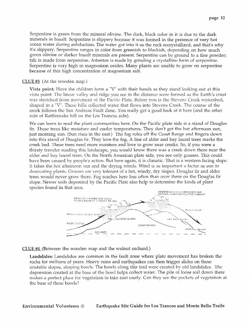
We can learn to read the plant communities here. On the Pacific plate side is a stand of Douglasfir. These trees like moisture and cooler temperatures. They don't get the hot afternoon sun,just morning sun. (Sun rises in the east.) The fog roles off the Coast Range and fingers downinto this stand of Douglas fir. They love the fog. A line of alder and bay laurel trees marks thecreek bed. These trees need more moisture and love to grow near creeks. So, if you were athirsty traveler reading this landscape, you would know there was a creek down there near thealder and bay laurel trees. On the North American plate side, you see only grasses. This couldhave been caused by people's action. But here again, it is climatic. That is a western facing slope.It takes the hot afternoon sun and the drying winds. Wind is as important a factor as sun indesiccating plants. Grasses are very tolerant of a hot, windy, dry slopes. Douglas fir and aldertrees would never grow there. Fog reaches here less often than over there on the Douglas firslope. Newer soils deposited by the Pacific Plate also help to determine the kinds of plantspecies found in that area'
DES.ENDTNG ArR rs coMpRESsED AND
RISTNG AIR EXPANDS AND COOLS-RAISING RELATIVE HlJMIDITY TO 1O%
COAST RAI'JGES
CENTRAL VALLEY
----\
CLUE #4 (Between the wooden map and the walnut orchard.)
Landslides: Landslides are conunon in the fault zone where plate movement has broken therocks for miliions of years. Heavy rains and earthquakes can then trigger slides on theseunstable slopes, shaping bowls. The bowls along this trail were created by old landslides. Thedepression created at the base of the bowl helps collect water. The pile of loose soil down theremakes a perfect place for vegetation to take root easily. Can they see the pockets of vegetation atthe base of these bowls?
PR€VA]L]NG 11:ST€RLY I ! INDS
Environmental Volunteers @ Earthquake Site Guide for Los Trancos and Monte Bello Trails
Page 13
CLUE #5
Walnut orchard: When you see those trees all lined up in neat rows, you know they weren'tplanted by natural seed dispersal. How did they grow like this? This used to be an English .walnut oichard. But the 1906 quake shook up the farmer as well and he decided to leave. His
orchard was right near ground rupture. Why did he plant here on this hill? (Because there is a
good source of water close to the surface here.) Let's investigate the next clue.
CLUE #6 (Turn right at the walnut orchard, you will be on Canyon Trail.)
Sag pond: Sag ponds form along strike slip faults. As two plates grind slowly past each other,thJ rocks at their margins are pulverized into fine particles. Have the kids simulate the plates
sliding past each other by sliding their index fingers alongside each other and applying Pressure/rq.t"uZng their fingers together as they try to slide them past each other. They can get a feelingof ho* the rocks would b-e ground into fine particles by this plate action. The finely groundrocks, down below the surface, create an impermeable clay barrier and water can not percolatethrough. Water collects and pools near or on the surface due to this impermeable boundary.
Finely ground serpentine rock is an important ingredient in this barrier.
This sag pond was formed where there was a bend in the plate boundary. When the plates
moved-the edges on the plates moved apart,leaving a gap. The gap filled with water because of
the barrier created by the finely ground rocks. There are wet patches on the trail next to the sag
pond, present "rret'r
in dry summer and fall. There is a spring next to the sag gottq.These are
bther clues of surface wuter whose presence is due to the grinding action on the San Andreas
Fault.
It's also good to pause next the sag pond and talk about the plants !her9. Mention how we can
try to pr6di.t earlhquakes from sudden changes of water levels and radon gas levels in wells,
animal behavior and foreshocks before a "main event." EV Bob Dodge tells a good story about a
man hiking on Loma Prieta a week before the 1,989 quake. He noticed that water was running in
a creek in October, a time when the creek was normally dry. A week later, the quake struck. The
water table had changed! When looking out at Loma Prieta at the beginning of the hike, _mention that a section of that mountain moved 4 f.eet up and 6 feet north during the 1989
Loma Prieta Quake.
CLVE#7 (Continue along Canyon Trail, on the left hand side of the trail is the oak tree.)
Oak tree: This remarkable oak tree has twenty-two trunks. Have the children climb inside and
count. This growth form is not,typical for an oak. The main leader of the oak may have been
snapped off-during the violent shlking of the 1906 quake when it was still a young tree. These
muitiple trunks are the side shoots that grew after the main leader was broken off. If you find
oaks |ike this on fault zones, it is pssibly a sign that the trees may have been affected by the
ground movement. It is another clue to read. If we were to take a core sample of one of these
twenty-two trunks do you think the growth rings would date it back to sometime soon after
1906? Bay laurel trees grow like this naturally. Other trees will grow like this when their leader(the apical meristem) is broken off, releasing the lateral branches. This growth form is not
caused by earthquake shaking alone. But, here, in this place, it is a possiblC clue to indicate that
we are on a fault zone.
Environmental Volunteers @ Earthquake Site Guide for Los Trancos and Monte Bello Trails
page 14
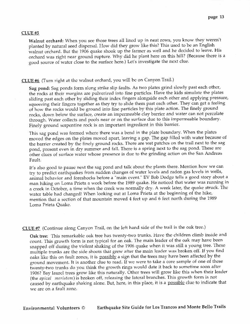
CLUE #8 (Off to the right side of the trail, down a short hill, in the meadow below you.)
Pressure ridge: A little past the sag pond a pressure ridge can be observed. The fault zone
continues through the meadow below the trail. Here you can see unusual patterns of ridges and
valleys. At the end of this guide is a diagram that you can cut to demonstrate the formation of
these ridges and valleys. The plates are pressing against each other to form a ridge that can be
seen running between the two valleys. See the diagram below.
presstr rc Lin ea r
Ridge Val le Y
Val lcY
CLUE #9 (Go back on Canyon Trail towards Page Mill Road, cross over to the Los Trancos side.)
Offset fence: Proceed across the road to the Los Trancos side to the fence off-set. (See Station #4,page 9 of this guide. ) On the way there, talk about earthquake stuff. Ask students questionsabout what happened during the classroom presentation portion of their Earthquake Program/what do they remember most from the learning stations. And, of course, there is a lot of forestand foothill environment to talk about. Have a measuring tape in your pack so the studentscan measure the amount of fence offset. Ask them which is the North American Plate side andwhich is the Pacific Plate side of the fence.
You can usually find another EV group near the fence (or split your group into two smallergroups). Have the two groups line up face to face. One group represents the North Americanplate the other is the Pacific plate. Have the kids put their hands out in front and link fingers.Have the American plate stand still and the Pacific plate move in increments (one or two stepsat a time) until everything gives. Explain that rocks in fault zones "bend" until they reach theirelastic limit. Then they break. There is a release of energy. Vibrations are sent through theearth's crust by this energy release. We know that as an earthquake. It is a misconception thatlittle quakes release the pressure of a fault zone.
RECAP:Rock Stratesy - have each person find a small rock; sitting in a circle have each Person examinehis/her rock very carefully. The field trip leader collects rocks and then asks the grouP to closetheir eyes; the leader then passes single rocks round in random order and each person tries toidentify his/her own special rock by touch only.
Ask one or more of the following questions:What will happen in the future in this earthquake area?\Alhat did you find the most interesting about this trip? (Each Person should give a differentanswer.)What is the first thing you will do to prepare for an earthquake?What did you learn that was new to you?What is a bench, a sag pond, a linear ridge, etc.?
r'b ="ri
Environmental Volunteers @ Earthquake Site Guide for Los Trancos and Monte Bello Trails

page 15
Imagine a Quake:Ask the group to visualize what would happen - i.e., what they would see, hear, feel, during
a major slip event on this section of the San Andreas Fault if they were standing:
1) in the parking lot (open ground),2) in the forest near Stations 8-11,3) on a steep hillside such as Station 3, or4) at home.
EARTHQUAKE TRAIL VOCABULARY
Aftershocks:Smaller earthquakes following the strongest shake.
Bench:Fiat road-like area, where landslides have fil led in an area after fault action.
Collision zone:An area where two plates carrying continents collide to form mountains.
Conglomerate:Gravel and rock cobbles imbedded in a matrix of another material, such as sandstone.
Continental crust:The part of the earth's crust that includes the land masses, mostly composed of light granitic
rock.
Continental drift:The theory of continents breaking away from one original land mass and moving slowly
apart over time.layer and a solid center.
Creep:Slow, continuous slipping of earth along a fault, which does not result in earthquakes.
Crust:The outermost, solid shell of the earth from 4 to 45 miles thick.
Earthquake:The earth vibrations caused by passing seismic waves that come from release of energy
when sudden movement occurs along a fault.
Epicenter:The point on the earth's surface directly above the place where the rock first breaks or slips
in an earthquake.
Fault:Weak zone or break in earth's crust where rocks have fractured and moved
Environmental Volunteers O Earthquake Site Guide for Los Trancos and Monte Bello Trails
Page 16
Focus:The place within the earth where rock first breaks or slips in an earthquake and the originof the seismic waves that follow.
Geology:The study of the earth's history and structure.
Igneous rock:A tyPe of rock which originates when molten magna cools and crystallizes.
Intensity:A measure of the local effects of an earthquake obtained from reports of damage done tostructures and other observed effects.
L waves:One kind of earthquake wave that travels on the surface of the earth,'preceded by P and Swaves.
Linear Valley:A valley produced by fault action, like the one that now contains Crystal Springs Reservoirand San Andreas Lake.
Liquefaction:Water saturated soils, behaving like a liquid during an earthquake, resulting in groundfailure.
Magnitude:A measurement of the strength or power of an earthquake.
Metamorphic rock:A type of rock formed when sedimentary or igneous rock buried deep in the earth issubjected to intense heat and increasing pressure over a prolonged period of time.
P waves:Primary compression waves caused by earthquakes, the fastest travelers, are recorded firston a seismogram. These waves cause particles in the earth's material to compress andexpand in the same direction that the waves move.
Richter scale:Scale for measuring earthquake magnitude (strength), invented by Charles Richter in i.935.
Right-lateral fault:A fault where the movement of the far block is to the right when viewed from either side.
S waves:The secondary or shear waves caused by earthquakes that travel more slowly than P waves,but not faster than L waves, moving away from the focal point and which move matter atright angles to the wave's movement.
Environmental Volunteers @ Earthquake Site Guide for Los Trancos and Monte Bello Ttails
page 77
Sag pond:A depression found along fault zones that fills with water.
Sedimentary rock:Rock formed from the weathered pieces of other rocks which have been transported,deposited and then compacted and/or cemented..
Seismic waves:Waves in the earth caused by earthquakes or explosions.
Seismograph:An instrument which detects and records earth motions produced by passing seismicwaves.
Spreading zorre:An area of new crust, formed where two plates spread apart.
Stress:The forces that pull, push, twist and squeeze rock.
Subduction zone:The place where one plate sinks beneath another to be recycled back into mantle material(usually a heavy oceanic plate sinking beneath a lighter continental plate in an oceantrench).
Transform fault:A fault created when two plates that grind past each other horizontally.
Volcano:An opening in the earth's crust where magma reaches the surface and often forms cone-shaped mountains.
ADDITIONAL RESOURCES:See the Environmental Volunteers Earth+uake GuideContact U.S.G.S. (41.5/329-5104), they have a wealth of free information.
Environmental Volunteers @ Earthquake site Guide for Los Trancos and Monte Belto Trails

Note: Cut slits along dotted lines.sides of the paper according
page 18
Place the sheet on a smooth, flat surface, then slowly move theto the marked arrows.
Environmental Volunteers @ Earthquake Site Guide for Los Trancos and Monte Bello Trails
Bet.Jeen o ne-t .oo cni i \ r 'on
oxo
onJ
'$ eqf s
D
\ '
-
page t9
*-- --:>
-_---_---:
Fo.i{,.L
) ) t
Il (or{K-H*..,L. ..,
F \*te-
v1t,
t lII
iltF\".1<-
[Vo.A
Los Tro,nco5Earlh g.tro-ke_
T..-Y.l
Note: GIue a copv of fh iq di . - -^* ^-pr"r" "r'ifJ"tf
this diagram on to cardboard, then cut.along the center line. Moveb o* *;;k; ; ;,ff H:T:::;:il[H*T,:i:i o"",,.. a ;;;i? il *i,,,,*"ra tes j the Pacifictouch the
Environmental volunteers @ Earthquake site Guide for Los Trancos and Monte BeIIo Trails
L orna. i Prreta.